
.

🌪️ Seven-Day Tornado Outlook ⛈️
April 24th to May 1st
Current risk: POSSIBLE.
Current confidence level: Medium.
Comments: At this time, I am monitoring Monday and Monday night. Monday is the day with the greatest chance of severe weather. I can’t rule out some tornadoes. Monitor updates.
Double click on the graphic to enlarge it.
.

Seven-Day Hazardous Weather Outlook
1. Is lightning in the forecast? YES. Lightning is possible today. Isolated lightning is possible tonight. The risk of lightning on Saturday and Sunday is lower. The risk of lightning on Monday and Monday night is high. I am monitoring Tuesday through Friday of next week.
2. Are organized severe thunderstorms. YES. A small chance of a strong storm today. The severe risk is minimal.
I am monitoring Monday and Monday night. The risk of severe weather is higher on Monday and Monday night. I will monitor the middle and end of next week.
3. Is significant or widespread flash flooding in the forecast? NOT AT THIS TIME.
4. Will non-thunderstorm winds top 40 mph? NO.
5. Will the temperature rise above 90 degrees? NO.
6. Is the heat index forecast to rise above 100 degrees? NO.
.
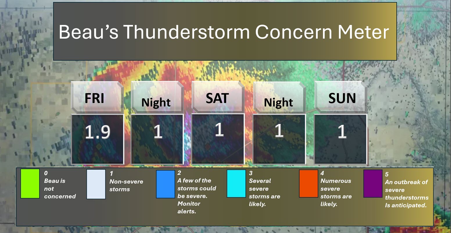
⛈️ Here is the short-range thunderstorm concern meter.
.
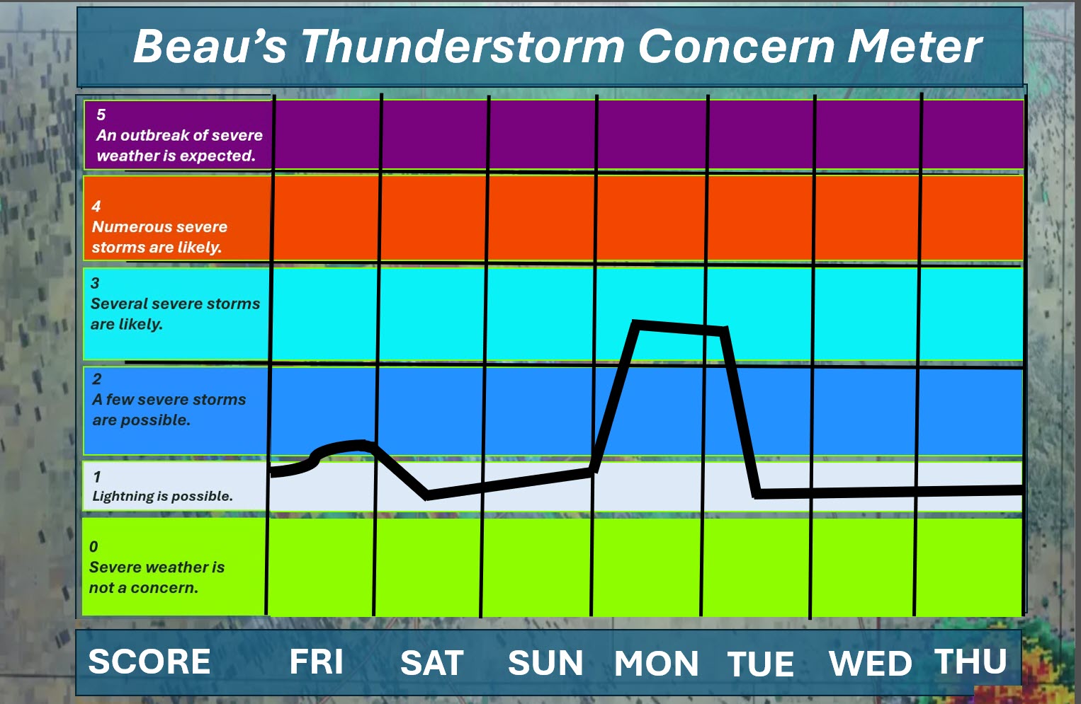
⛈️ Here is the extended thunderstorm concern meter.
.


.
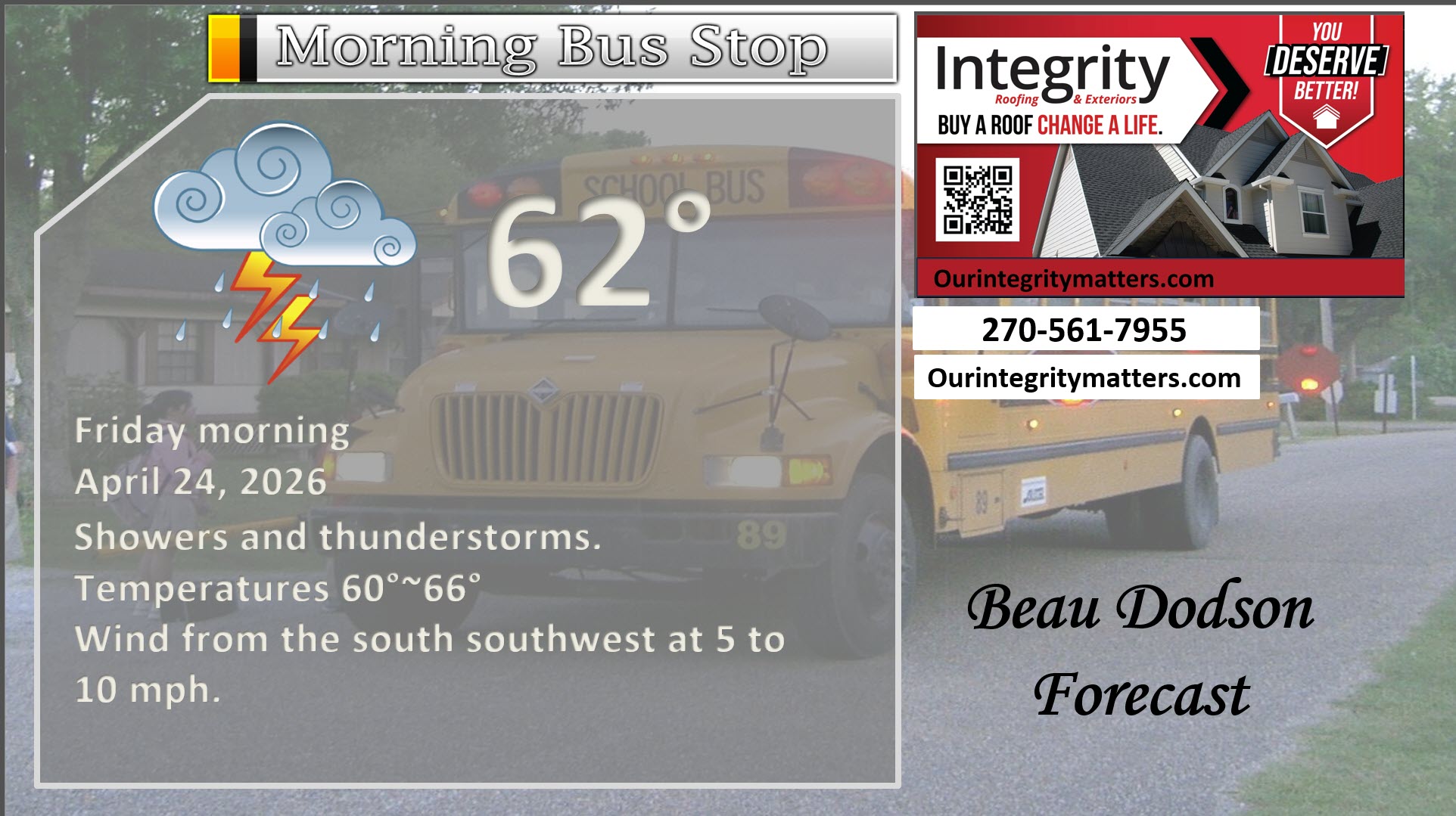
Here is your bus stop forecast
.
This morning
.
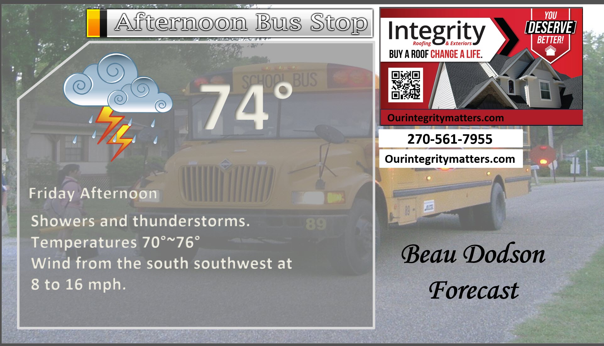
This afternoon
.
Tomorrow morning
.
Tomorrow afternoon
.
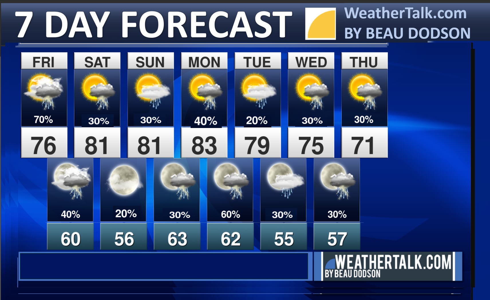
Seven-day outlook graphic.
See the video and graphics below for more details specific to your county. This is a broad-brush overview of the entire region.
.


Forecast discussion
- Showers and thunderstorms today. Scattered tonight.
- Mostly dry on Saturday (a low-end chance of rain). A few showers and storms are possible Sunday and Sunday night.
- Severe thunderstorms are possible on Monday and Monday night.
- I will monitor the middle and end of next week for additional chances of thunderstorms.
 .
.
.
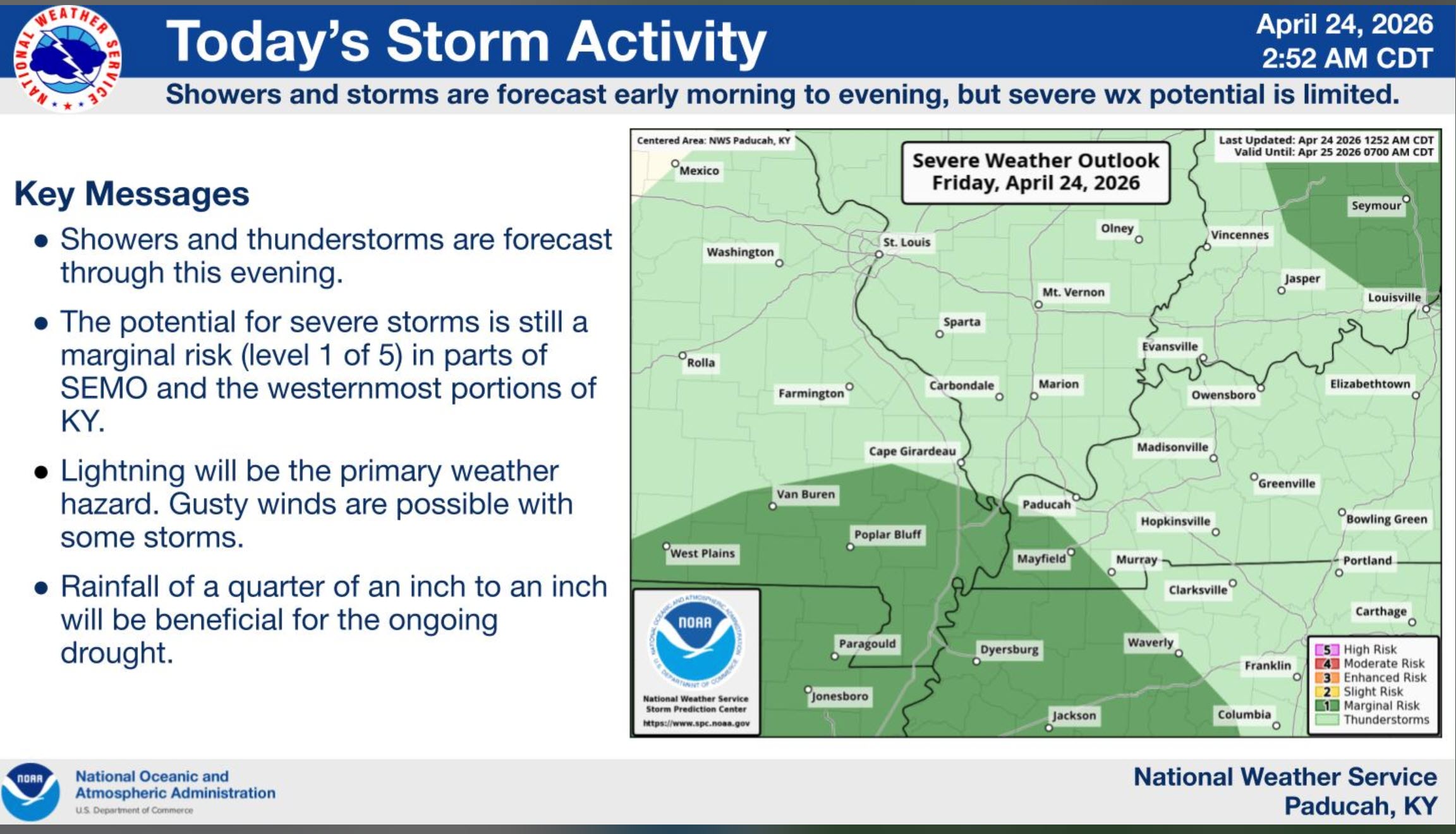
What is the primary weather concern today and tonight?
Showers and thunderstorms today. A low risk of a strong thunderstorm.
.
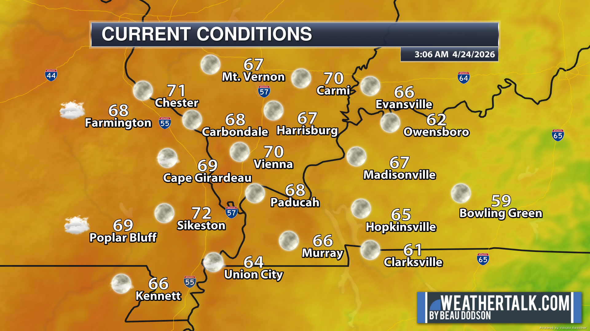
Here are the early morning current conditions. These are the 4 AM readings.
.
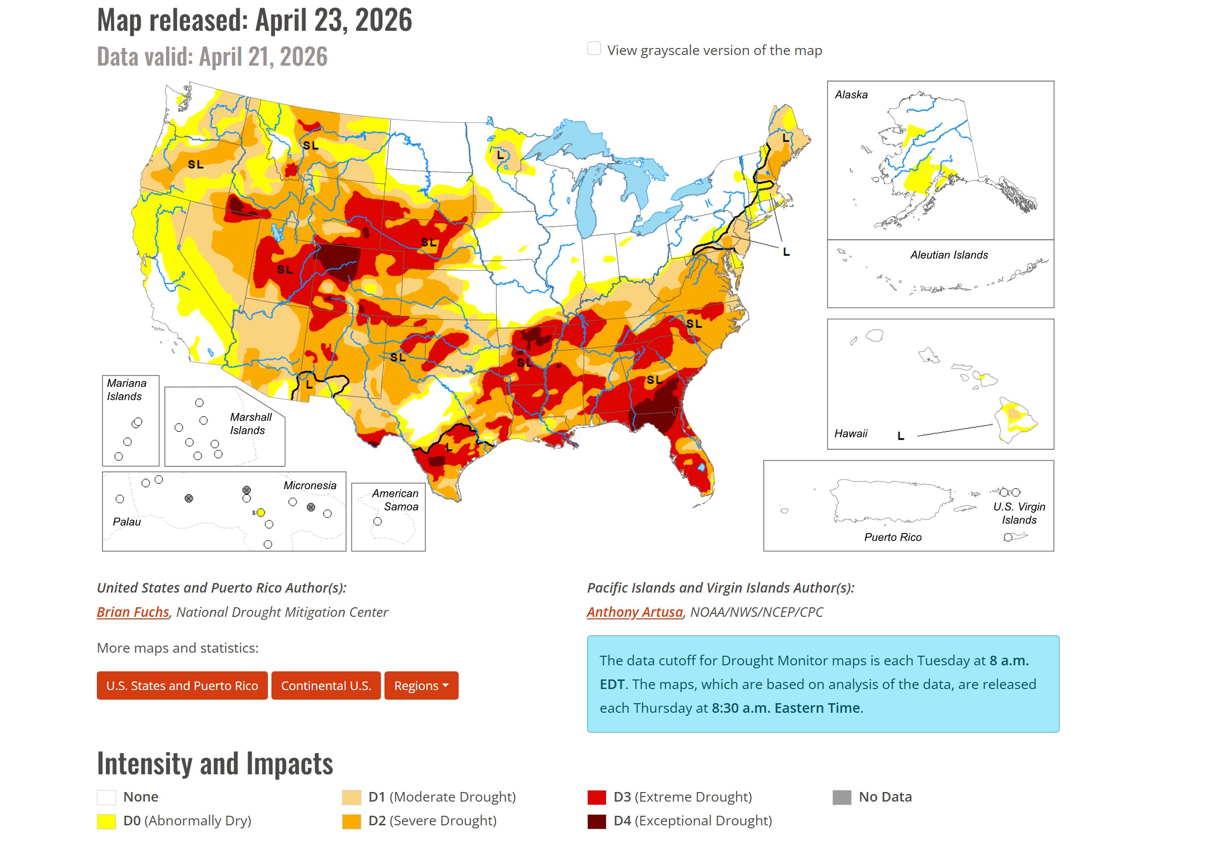
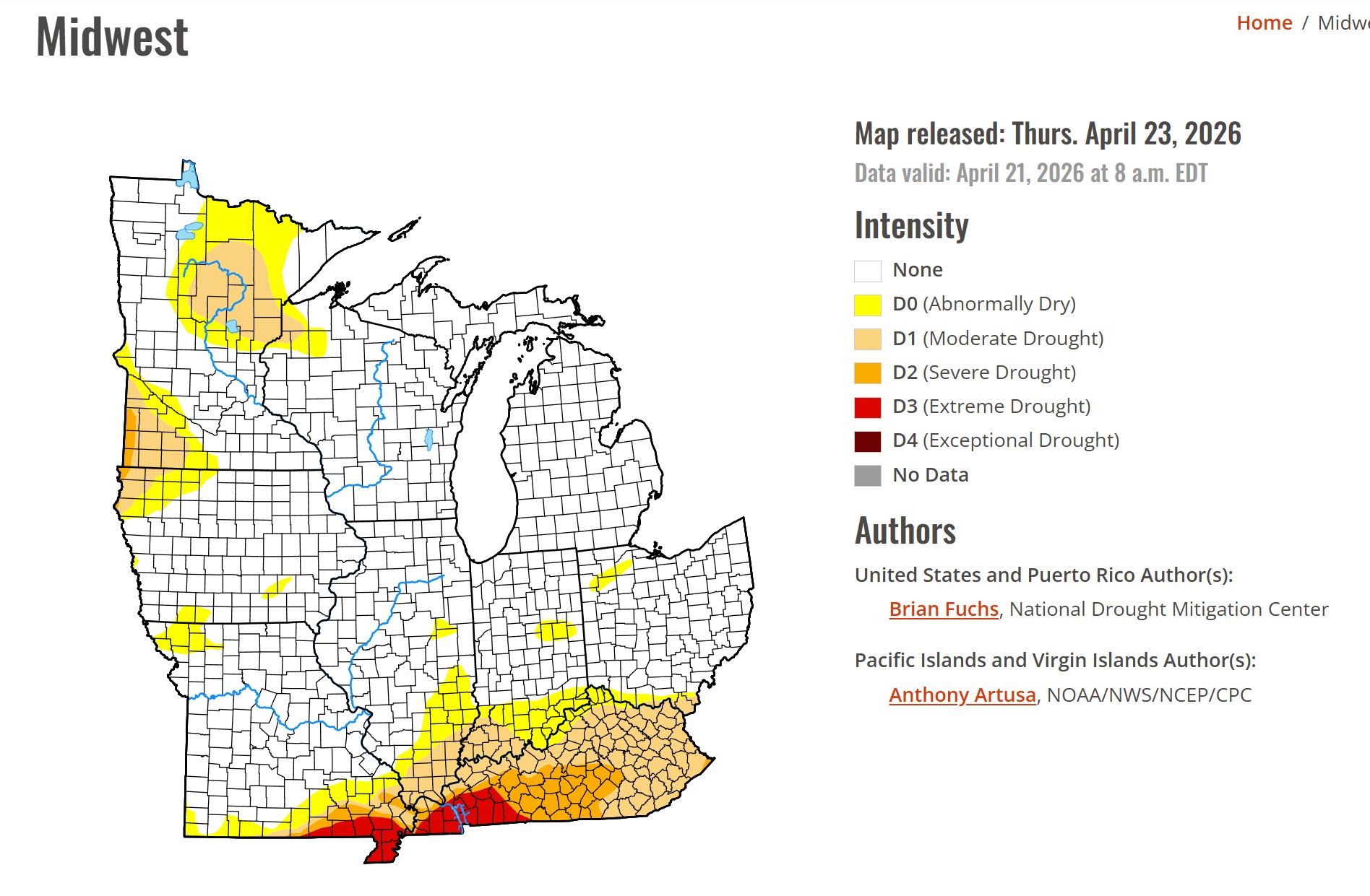
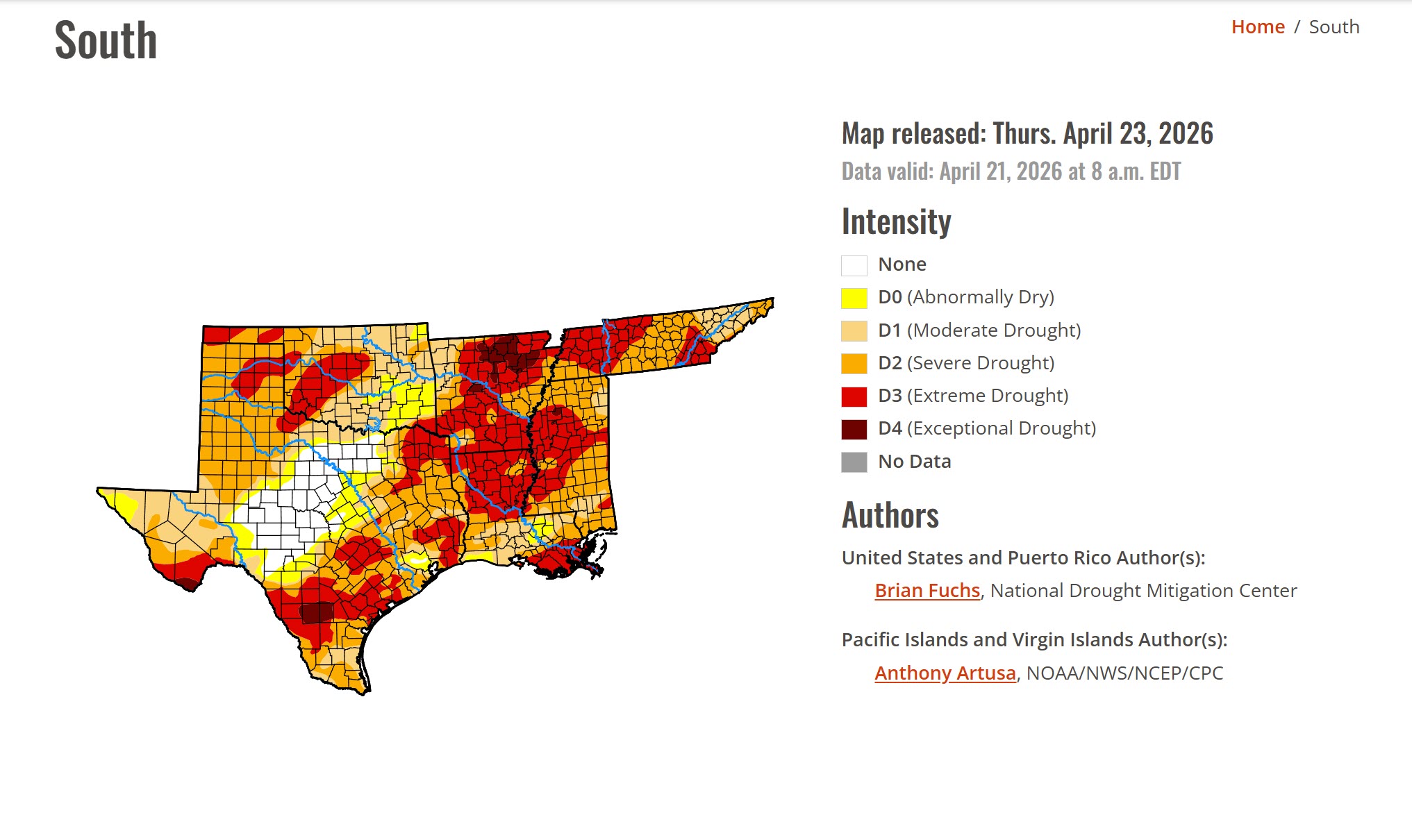
The new drought maps have been posted. Portions of our region remain in severe drought.
Double-click graphics to enlarge them.
.
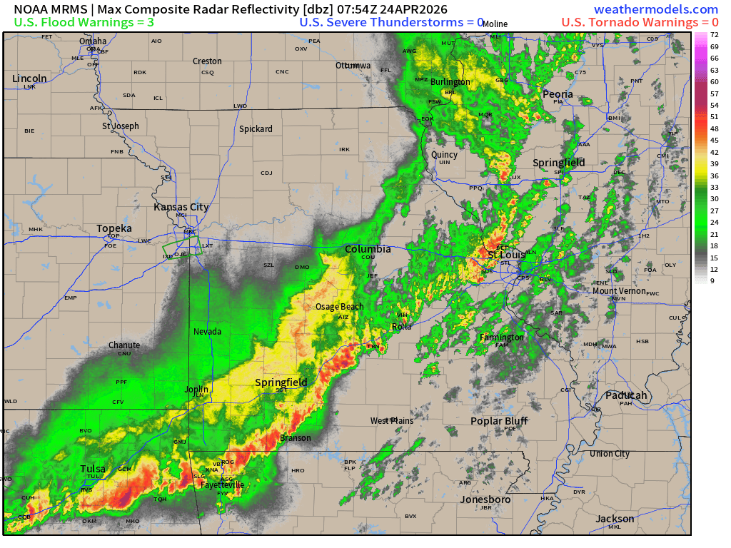
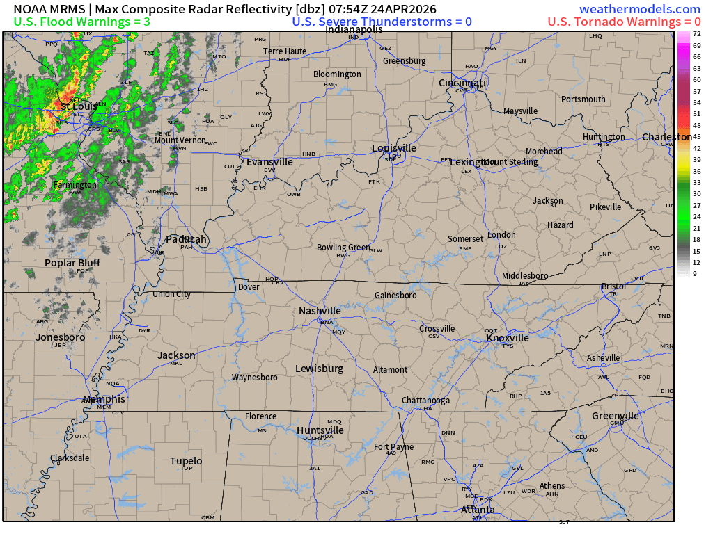
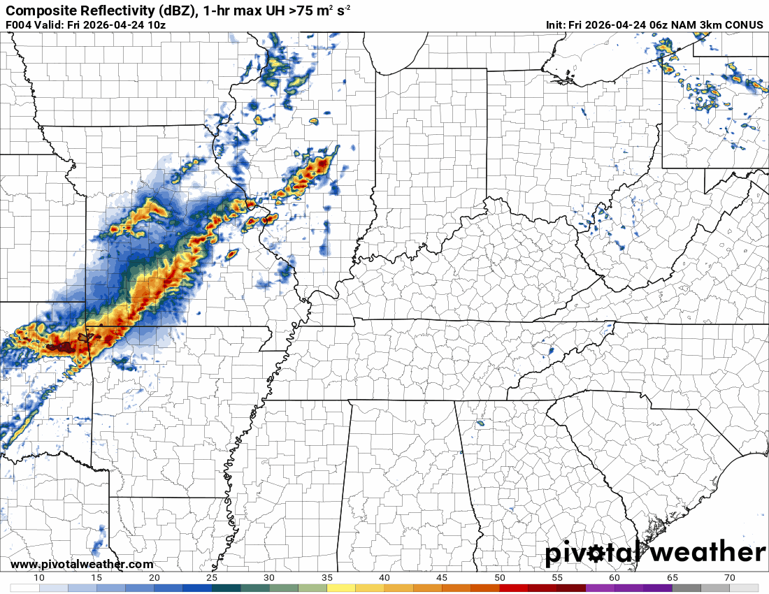
A line of showers and thunderstorms is moving into the region.
You can see that on the 4 am radar animations. See the live radar links below.
This line is weakening as it advances eastward.
.
.

Radars and Lightning Data
Interactive-city-view radars. Clickable watches and warnings.
https://wtalk.co/B3XHASFZ
Regional Radar
https://imagery.weathertalk.com/prx/RadarLoop.mp4
** NEW ** Zoom radar with chaser tracking abilities!
ZoomRadar
Lightning Data (zoom in and out of your local area)
https://wtalk.co/WJ3SN5UZ
.
A few of the thunderstorms today could produce strong wind gusts and nickel-sized hail. The risk of organized severe weather is low, but perhaps not zero.
Here is the official Storm Prediction Center severe weather outlook. As you can see, there is a low level risk in the dark green zone.
That includes far southeast Missouri into western Tennessee. It clips southwest Kentucky.
The light green zone is where storms are possible, but likely below severe levels.
.
Again, the line on the radar is weakening as it moves eastward.
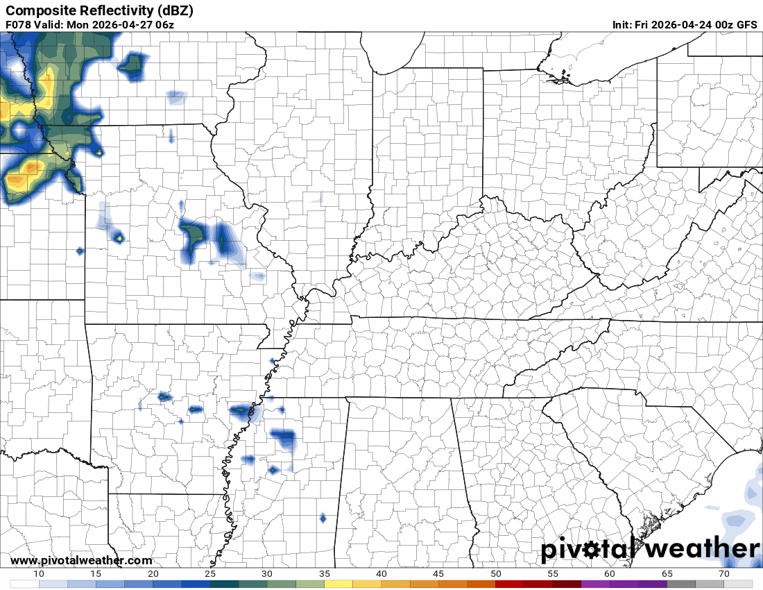
A couple of showers may linger into Saturday and Sunday. Most of the area will remain dry after sunrise on Saturday. A few locations could receive a brief shower.
Some of the guidance shows an area of showers moving across southern Missouri into portions of western Kentucky and Tennessee on Sunday. For now, I kept rain chances low.
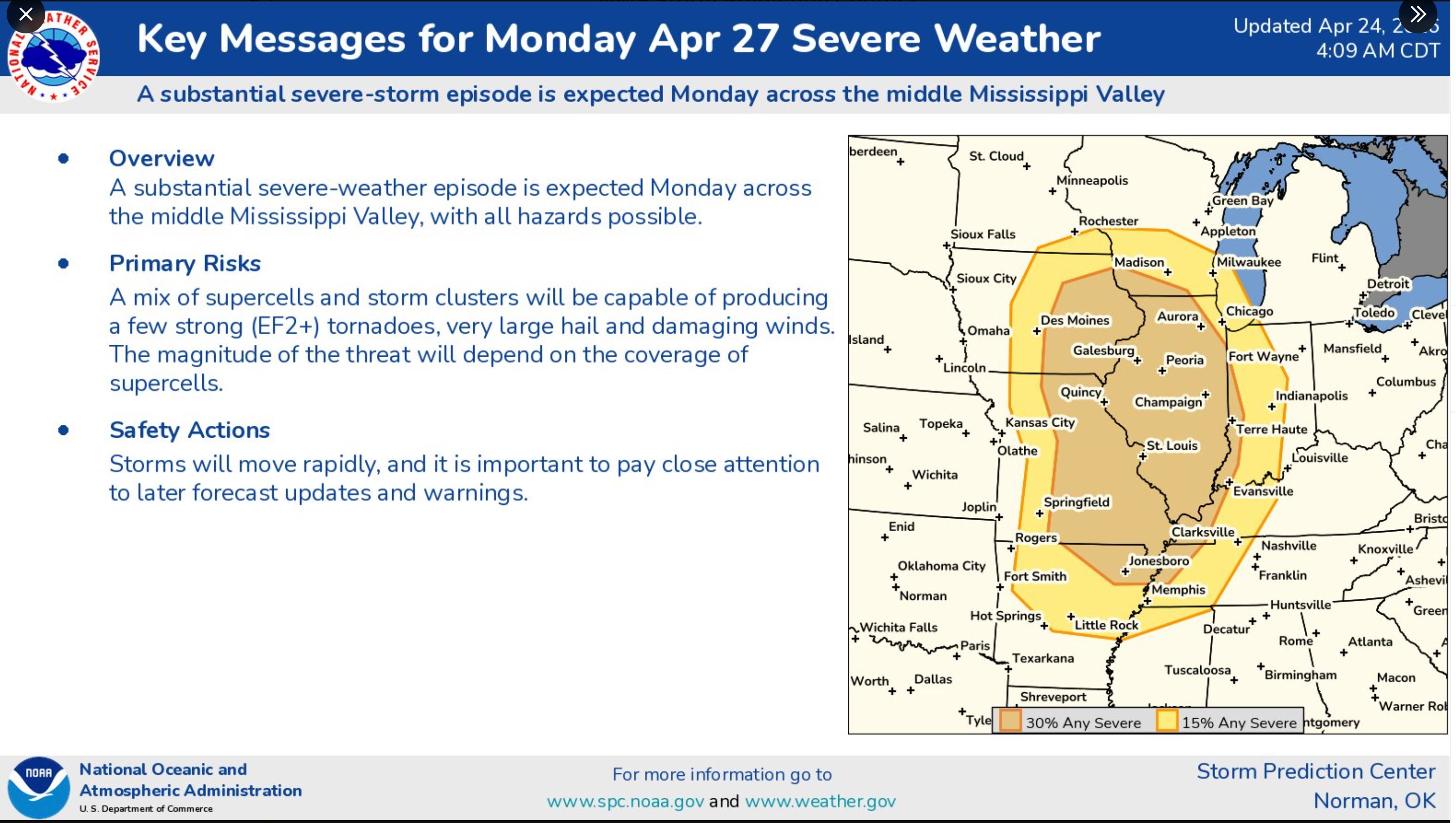
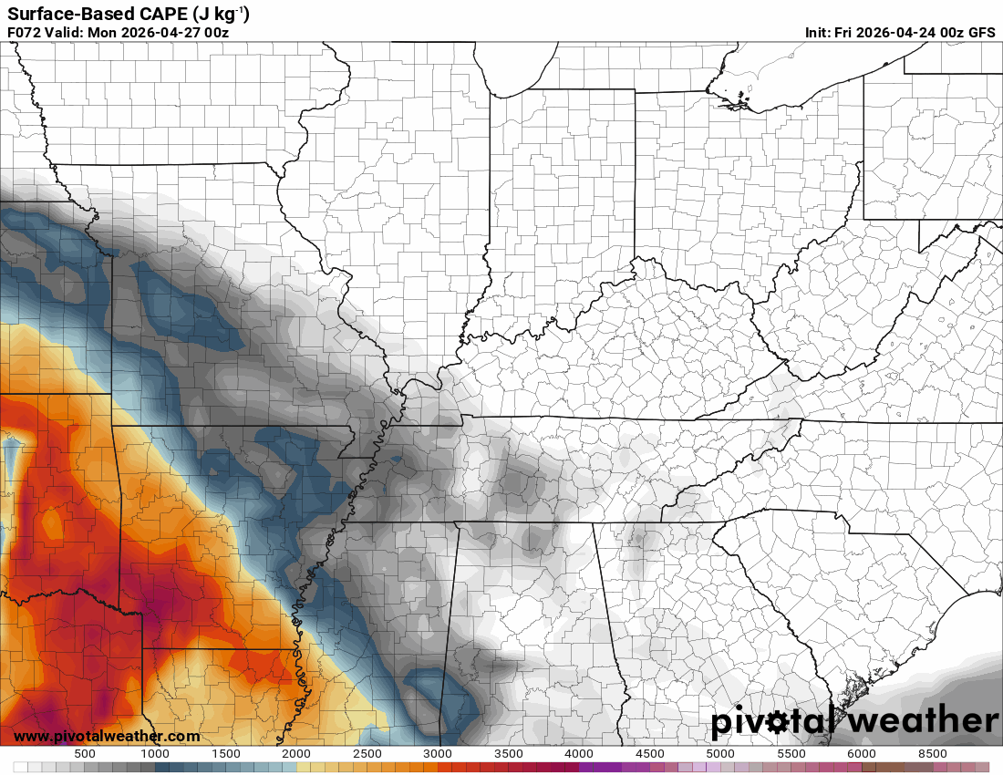
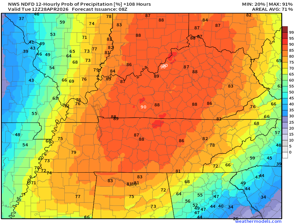
Monday’s Severe Weather Potential
A stronger system will move into the region on Monday. Some of those thunderstorms could be severe. The risk will be damaging winds, large hail, and even tornadoes.
Here are the CAPE values from the GFS model.
CAPE is energy that thunderstorms tap into.
You can see it peaks over our western and northwestern counties on Monday afternoon and evening.
.
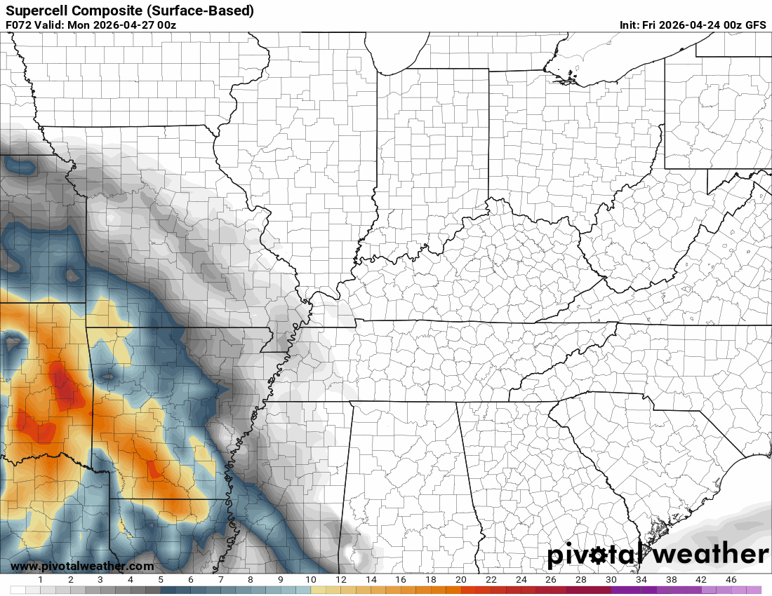
Here is the supercell composite. Supercells tend to produce higher-end severe weather. That includes tornadoes.
I am monitoring the trends in the guidance.
.
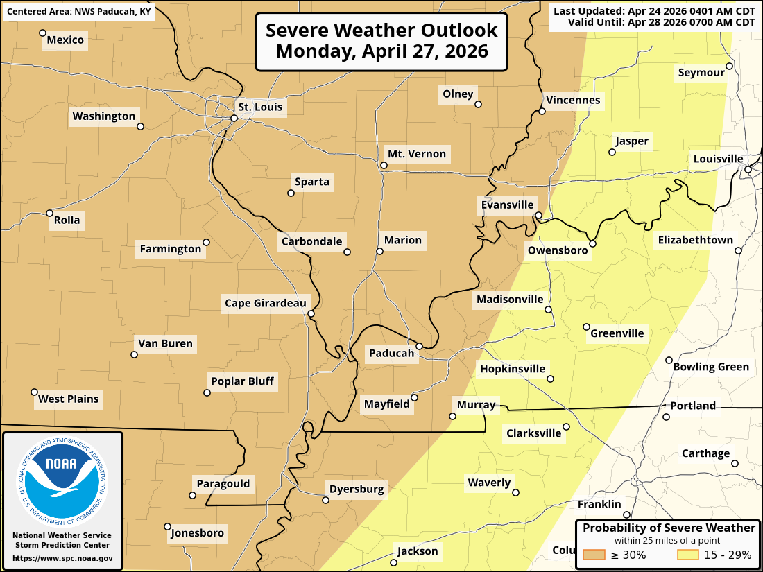
The Storm Prediction Center has outlined our region for a level two and three severe weather risk. The levels range from one to five.
A lot of questions remain.
This is concerning four days out. Monitor updates over the coming days.
I will send out some app notifications, as well.
This severe weather outlook will likely continue to shift around a bit. This won’t be the final forecast. We have several days to go.
Here is the latest Monday severe weather outlook. The yellow is a level 2 out of 5 risk zone. The orange is a level 3 out of 5 risk zone.
This is mainly for Monday afternoon and Monday night.
.
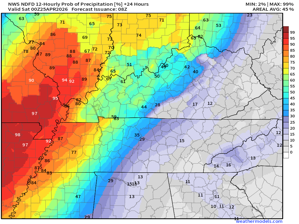
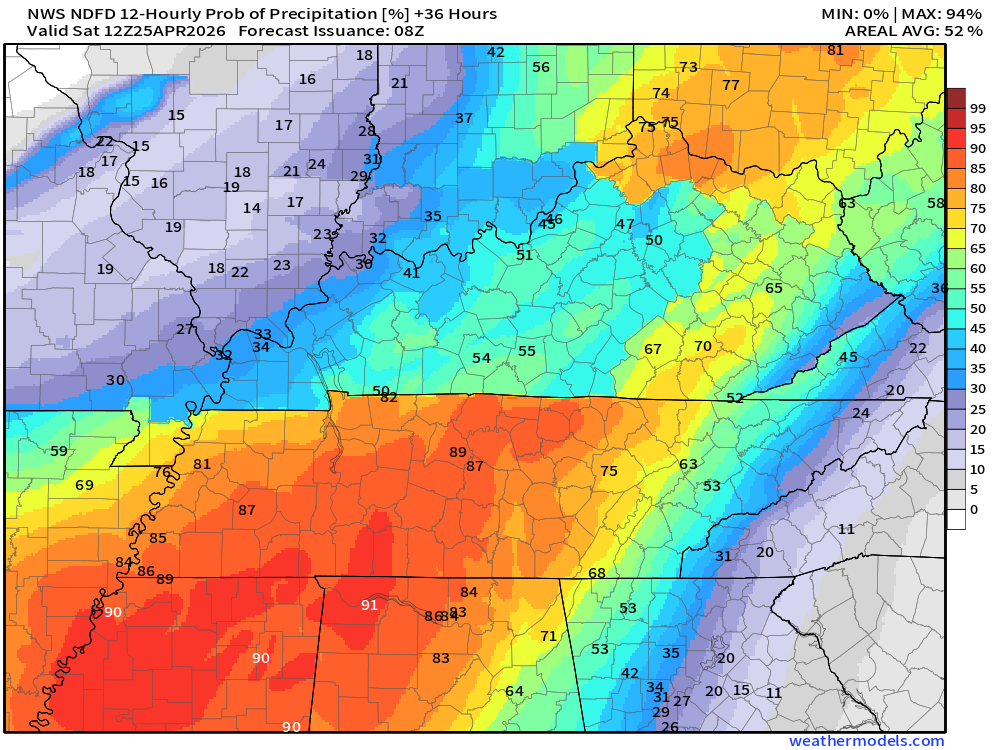
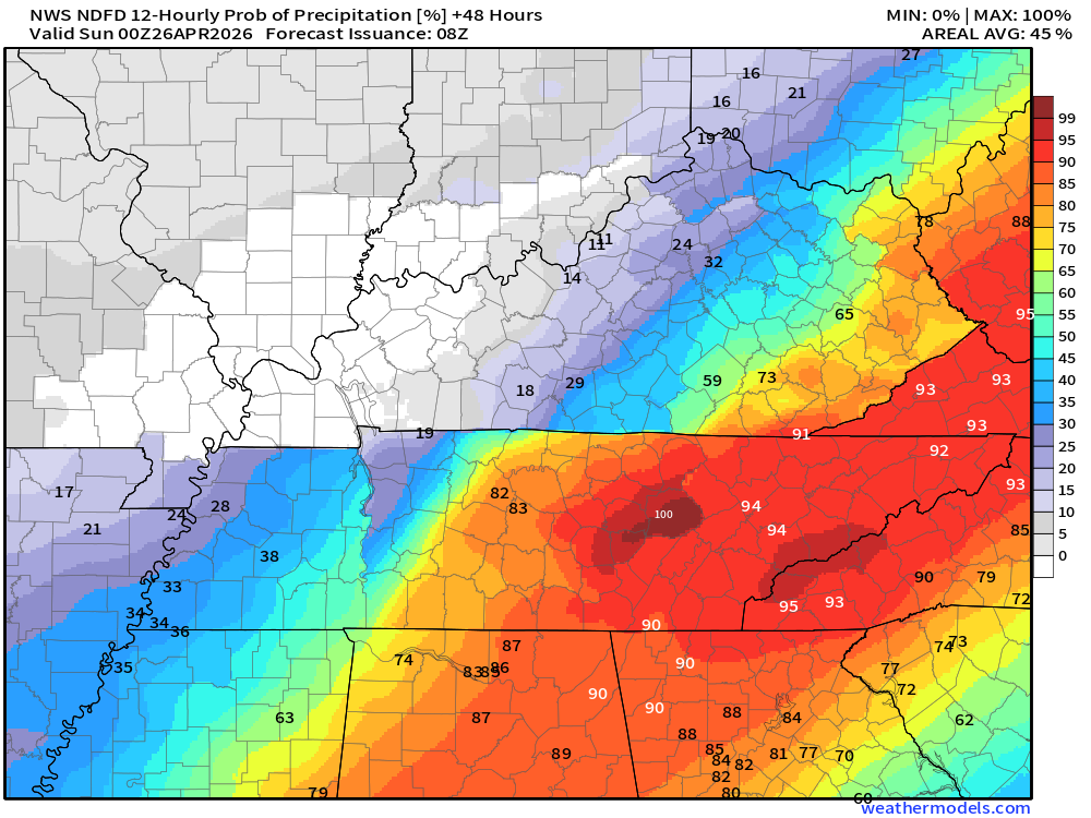
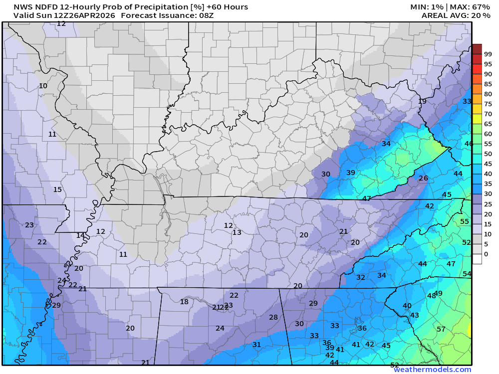
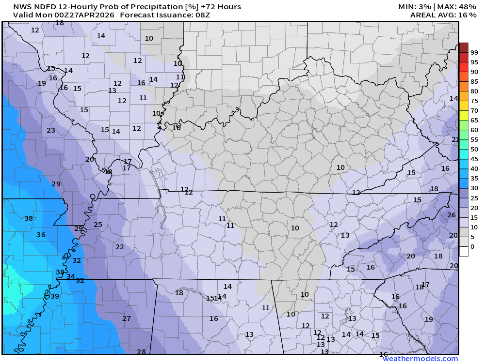
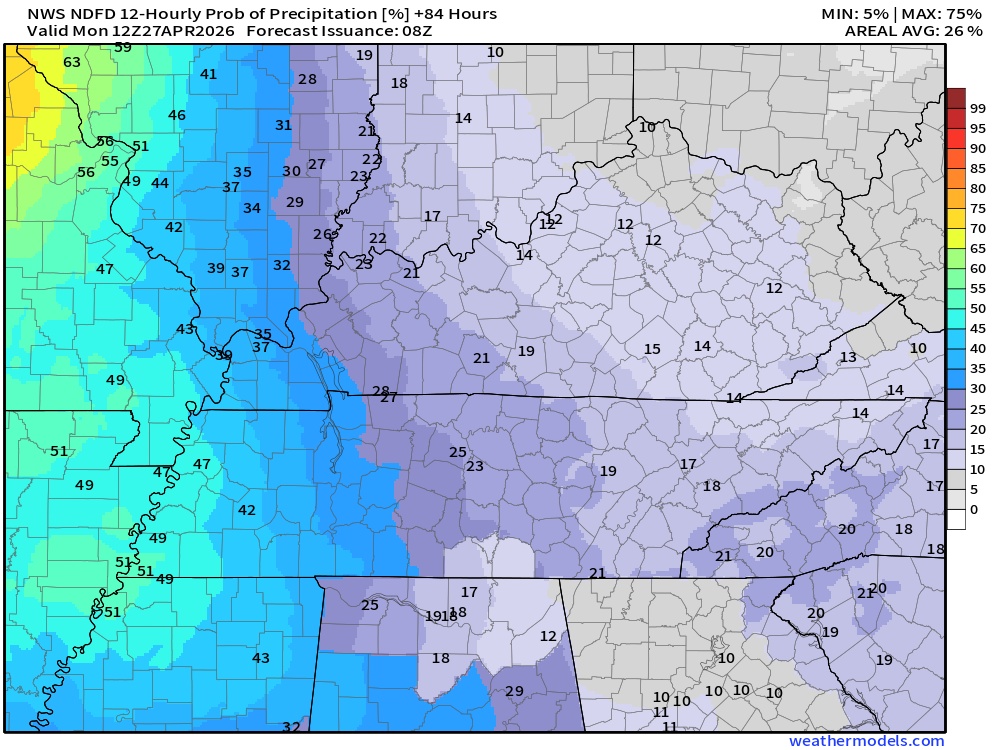
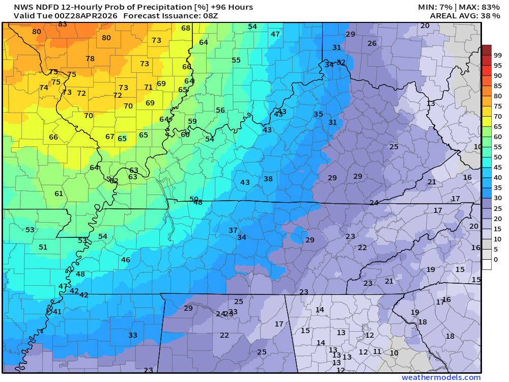
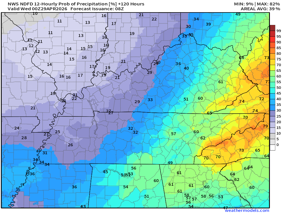
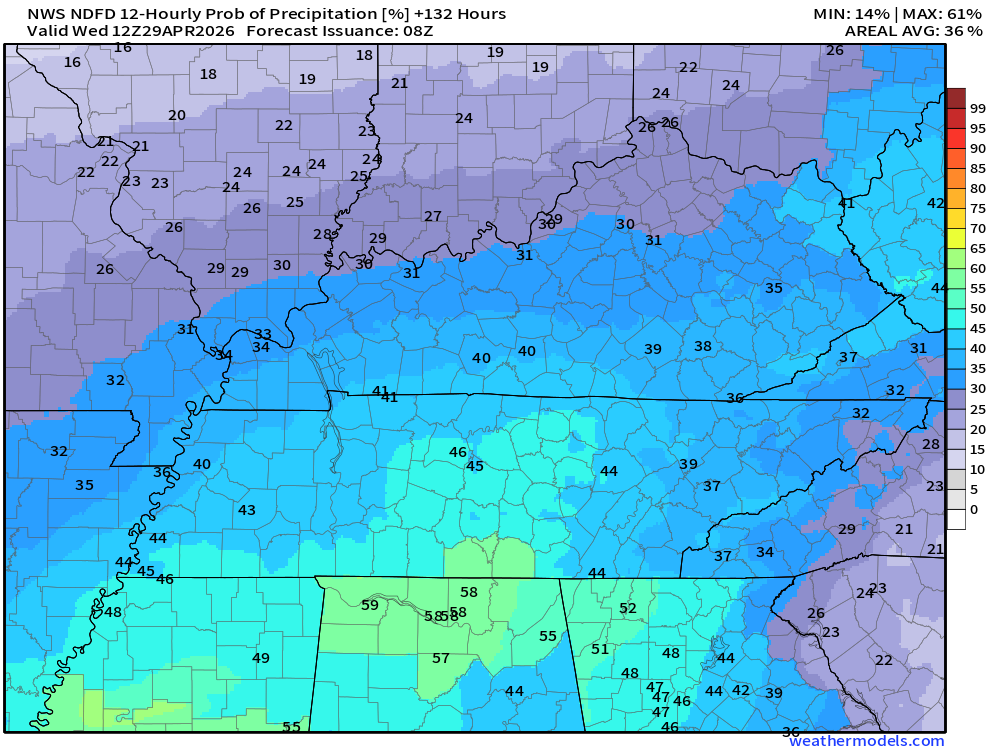
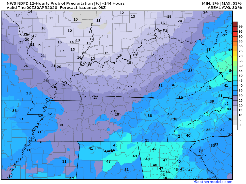
Let’s look at those rain probabilities.
What is the % chance of rain?
Double-click images to enlarge them.
.
.
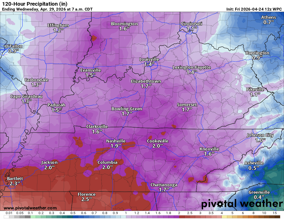
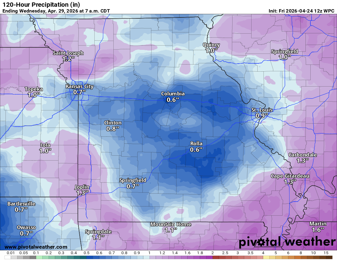
Let’s look at rainfall totals.
The WPC NOAA maps have been too high over the past several months.
Let’s see how this trends. Hopefully, it will be close to accurate.
We are in a drought. Some areas are in severe drought.
Rainfall totals today will likely range from 0.01 to 0.30″. Locally higher in thunderstorms.
This is the seven-day rainfall outlook. This is through next Tuesday morning.
Additional rain is possible later in the week, as well.
Double click to enlarge the graphics.Eastern view of our local area.
.
Western view of our local area.
.

.
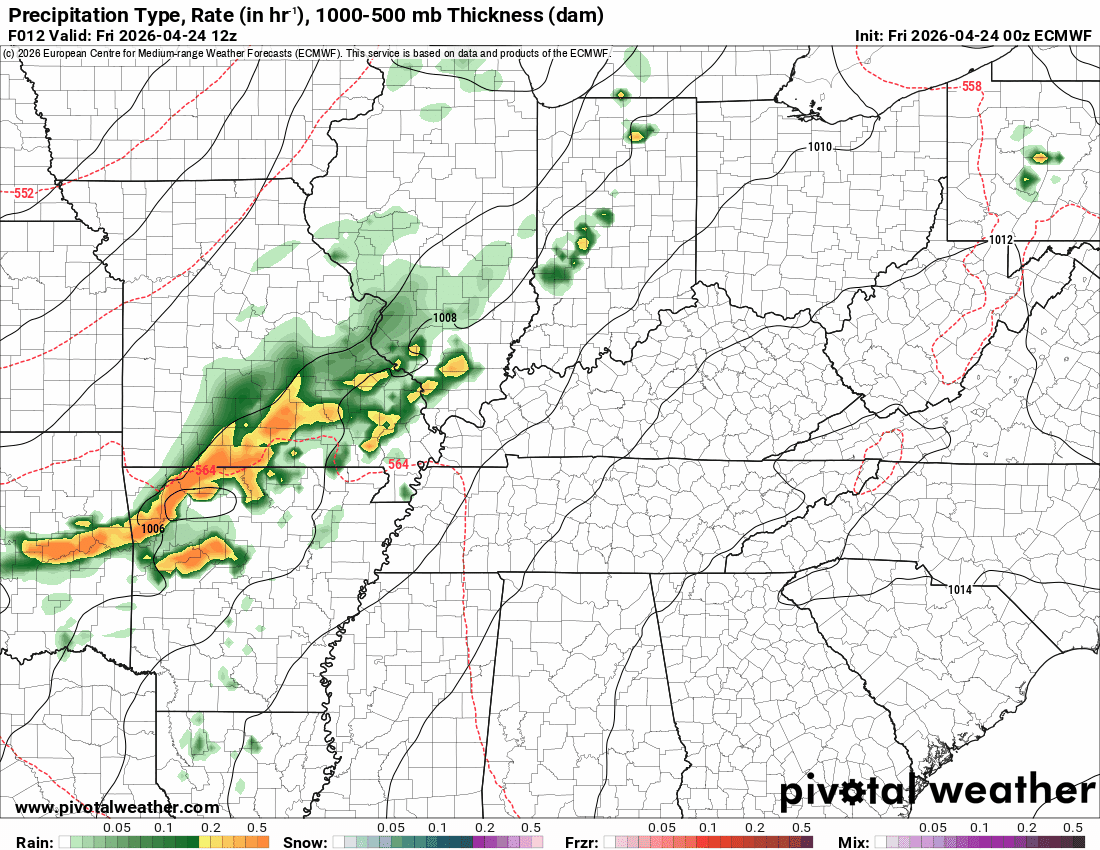
The timestamp (upper left) is in Zulu. 12z=7 am. 18z=1 pm. 00z=7 pm.
Green is rain. Yellow is moderate rain. Orange indicates locally heavy rain.
This model pops most of the storms east northeast of our region (on Thursday PM)
Double-click the animation to enlarge it.
NAM 3K Model
.
The timestamp (upper left) is in Zulu. 12z=7 am. 18z=1 pm. 00z=7 pm.
Green is rain. Yellow is moderate rain. Orange indicates locally heavy rain.
Double-click the animation to enlarge it.
GFS Model
.
.
The timestamp (upper left) is in Zulu. 12z=7 am. 18z=1 pm. 00z=7 pm.
Green is rain. Yellow is moderate rain. Orange indicates locally heavy rain.
Double-click the animation to enlarge it.
NAM 3K Model
.
..
.
Click here if you would like to return to the top of the page.
.Average high temperatures for this time of the year are around 69 degrees.
Average low temperatures for this time of the year are around 46 degrees.
Average precipitation during this time period ranges from 1.00″ to 1.20″
Six to Ten Day Outlook.
Blue is below average. Red is above average. The no color zone represents equal chances.
Average highs for this time of the year are in the lower 60s. Average lows for this time of the year are in the lower 40s.

Green is above average precipitation. Yellow and brown favors below-average precipitation. Average precipitation for this time of the year is around one inch per week.

.

Average low temperatures for this time of the year are around 47 degrees.
Average precipitation during this time period ranges from 1.00″ to 1.30″
.
Eight to Fourteen Day Outlook.
Blue is below average. Red is above average. The no color zone represents equal chances.

Green is above average precipitation. Yellow and brown favors below average precipitation. Average precipitation for this time of the year is around one inch per week.

.
.
.
We have a new service to complement your www.weathertalk.com subscription. This does NOT replace www.weathertalk.com It is simply another tool for you to receive severe weather information.
.
https://weathercallservices.com/beau-dodson-weather


Want to receive the daily forecast/other products on your Beau Dodson Weather app?
Did you know you have four options in your www.weathertalk.com account
You will then receive these via your Beau Dodson Weather app.
Just log into your www.weathertalk.com account
Click the NOTIFICATION SETTINGS TAB
Then, turn them on (green) and off (red)
🌪️ Number 1 is the most important one. Severe alerts, tornado alerts, and so on.
Number 2 is the daily video, blog, livestream alerts, and severe weather Facebook threads on severe days or winter storm days.
Number 3 is the daily forecast. I send that out every day during the afternoon hours. It is the seven-day forecast, hazardous weather outlook, fire outlook, and more.
Number 4 is to receive the daily video, blog, and other content on NON-severe weather days (every day without severe threats in other words)
GREEN IS ON
RED IS OFF

Radars and Lightning Data
Interactive-city-view radars. Clickable watches and warnings.
https://wtalk.co/B3XHASFZ
Old legacy radar site (some of you like it better)
https://weatherobservatory.com/weather-radar.htm
If the radar is not updating then try another one. If a radar does not appear to be refreshing then hit Ctrl F5. You may also try restarting your browser.
Backup radar site in case the above one is not working.
https://weathertalk.com/morani
Regional Radar
https://imagery.weathertalk.com/prx/RadarLoop.mp4
** NEW ** Zoom radar with chaser tracking abilities!
ZoomRadar
If the radar is not working, then email me: Email me at beaudodson@usawx.com
.
We do have some sponsors! Check them out.
Roof damage from recent storms? Link – Click here
INTEGRITY ROOFING AND EXTERIORS!
⛈️ Roof or gutter damage from recent storms? Today’s weather is sponsored by Integrity Roofing. Check out their website at this link https://www.ourintegritymatters.com/

![]()
![]()
![]()
Make sure you have three to five ways of receiving your severe weather information.
Weather Talk is one of those ways! Now, I have another product for you and your family.

.
Want to add more products to your Beau Dodson Weather App?
Receive daily videos, weather blog updates on normal weather days and severe weather and winter storm days, your county by county weather forecast, and more!
Here is how to do add those additional products to your app notification settings!
Here is a video on how to update your Beau Dodson Weather payment.
The app is for subscribers. Subscribe at www.weathertalk.com/welcome then go to your app store and search for WeatherTalk
Subscribers, PLEASE USE THE APP. ATT and Verizon are not reliable during severe weather. They are delaying text messages.
The app is under WeatherTalk in the app store.

Apple users click here

Android users click here
.
Radars and Lightning Data
Interactive-city-view radars. Clickable watches and warnings.
https://wtalk.co/B3XHASFZ
Old legacy radar site (some of you like it better)
https://weatherobservatory.com/weather-radar.htm
If the radar is not updating then try another one. If a radar does not appear to be refreshing then hit Ctrl F5. You may also try restarting your browser.
Backup radar site in case the above one is not working.
https://weathertalk.com/morani
Regional Radar
https://imagery.weathertalk.com/prx/RadarLoop.mp4
** NEW ** Zoom radar with chaser tracking abilities!
ZoomRadar
Lightning Data (zoom in and out of your local area)
https://wtalk.co/WJ3SN5UZ
Not working? Email me at beaudodson@usawx.com
National map of weather watches and warnings. Click here.
Storm Prediction Center. Click here.
Weather Prediction Center. Click here.
.

Live lightning data: Click here.
Real time lightning data (another one) https://map.blitzortung.org/#5.02/37.95/-86.99
Our new Zoom radar with storm chases
.
.

Interactive GOES R satellite. Track clouds. Click here.
GOES 16 slider tool. Click here.
College of DuPage satellites. Click here
.

Here are the latest local river stage forecast numbers Click Here.
Here are the latest lake stage forecast numbers for Kentucky Lake and Lake Barkley Click Here.
.
.
Find Beau on Facebook! Click the banner.


 .
.