We have some great sponsors for the Weather Talk Blog. Please let our sponsors know that you appreciate their support for the Weather Talk Blog.
Milner and Orr Funeral Home and Cremation Services located in Paducah, Kentucky and three other western Kentucky towns – at Milner and Orr they believe in families helping families. You can find Milner and Orr on Facebook, as well.
![]()
.

For all of your families eye care needs. Visit their web-site here. Or, you can also visit their Facebook page.
.

Best at Enabling Body Shop Profitability since 1996. Located In Paducah Kentucky and Evansville Indiana; serving all customers in between. They provide Customer Service, along with all the tools necessary for body shops to remain educated and competitive. Click the logo above for their main web-site. You can find McClintock Preferred Finishes on Facebook, as well

Expressway Carwash and Express Lube are a locally owned and operated full service Carwash and Lube established in 1987. We have been proudly serving the community for 29 years now at our Park Avenue location and 20 years at our Southside location. We have been lucky enough to partner with Sidecar Deli in 2015, which allows us to provide our customers with not only quality service, but quality food as well. . If you haven’t already, be sure to make Expressway your one stop shop, with our carwash, lube and deli. For hours of operation and pricing visit www.expresswashlube.com or Expressway Carwash on Facebook.

TORNADO SHELTERS! Endrizzi’s Storm Shelters – For more information click here. Endrizzi Contracting and Landscaping can be found on Facebook, as well – click here
I have launched the new weather texting service! I could use your help. Be sure and sign up and fully support all of the weather data you see each day.
This is a monthly subscription service. Supporting this helps support everything else. The cost is $3 a month for one phone, $5 a month for three phones, and $10 a month for seven phones.
For more information visit BeauDodsonWeather.com
Or directly sign up at Weathertalk.com


This forecast update covers far southern Illinois, far southeast Missouri, and far western Kentucky. See the coverage map on the right side of the blog.
Remember that weather evolves. Check back frequently for updates, especially during active weather.

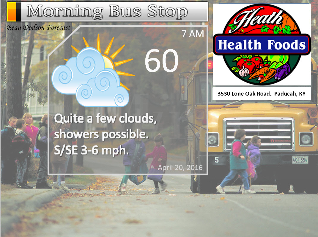
Tuesday Night – Partly cloudy. A chance for scattered showers. A rumble of thunder possible.
Temperatures: Lows in the upper 50s to lower 60s
Winds: Winds south at 6-12 mph.
What is the chance for precipitation? 30%-40%
Coverage of precipitation? Scattered
My confidence in this part of the forecast verifying is High
Should I be concerned about snow or ice? No
Should I cancel my outdoor plans? No, but monitor radars
Is severe weather expected? No
What impact is expected? Wet roadways. Lightning possible.
Interactive City View Radars for the entire region – click here
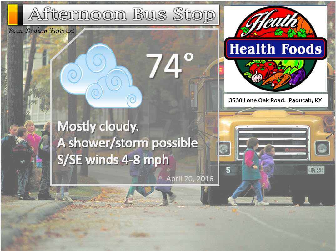
Wednesday – Partly to mostly cloudy. Mild. Showers and thunderstorms scattered in the area.
Temperatures: High temperatures 70-75 degrees.
Winds: South winds at 10 mph.
What is the chance for precipitation? 50%-60%
Coverage of precipitation? Numerous showers possible
My confidence in this part of the forecast verifying is High
Should I be concerned about snow or ice? No
Should I cancel my outdoor plans? I would monitor radar. Some showers possible.
Is severe weather expected? No
What impact is expected? Wet roadways. Maybe some lightning.
Wednesday Night – A good chance for showers. A thunderstorm possible.
Temperatures: Lows in the middle to upper 50s
Winds: Winds south at 10 mph.
What is the chance for precipitation? 60%-70%
Coverage of precipitation? Numerous to widespread
My confidence in this part of the forecast verifying is High
Should I be concerned about snow or ice? No
Should I cancel my outdoor plans? Have a back up plan
Is severe weather expected? No
What impact is expected? Wet roadways. Lightning possible.
Thursday – Cloudy. Warm. A chance for a showers and thunderstorms. Especially true for the eastern half of the region (east of the Mississippi River). Ending from west to east during the afternoon hours.
Temperatures: High temperatures 72-74 degrees.
Winds: South and southwest winds at 10 mph. Gusts to 20 mph. Winds may switch more W/SW in the afternoon.
What is the chance for precipitation? 40%-50% western counties. 50%-70% eastern counties.
Coverage of precipitation? Numerous to perhaps widespread
My confidence in this part of the forecast verifying is High
Should I be concerned about snow or ice? No
Should I cancel my outdoor plans? Have a back up plan
Is severe weather expected? No
What impact is expected? Wet roadways. Maybe some lightning.
Thursday Night – Cloudy. Showers coming to an end.
Temperatures: Lows in the middle 50s
Winds: Winds west and northwest at 6-12 mph. Gusts to 15 mph.
What is the chance for precipitation? 40% before midnight. 30% after midnight.
Coverage of precipitation? Scattered to perhaps numerous
My confidence in this part of the forecast verifying is Medium
Should I be concerned about snow or ice? No
Should I cancel my outdoor plans? Have a back up plan
Is severe weather expected? No
What impact is expected? Wet roadways.
Friday – A mix of sun and clouds. Mild. A few light showers possible.
Temperatures: High temperatures 70-75 degrees.
Winds: North winds at 10 mph.
What is the chance for precipitation? 20%-30% of a light shower
Coverage of precipitation? Isolated to scattered
My confidence in this part of the forecast verifying is Medium
Should I be concerned about snow or ice? No
Should I cancel my outdoor plans? No, but some a light shower is possible
Is severe weather expected? No
What impact is expected? Wet roadways possible.
Friday Night – Mostly clear. Cool for campers.
Temperatures: Lows from 46 to 52 degrees
Winds: North and Northwest at 5 mph
What is the chance for precipitation? 10%
Coverage of precipitation? None
My confidence in this part of the forecast verifying is Medium
Should I be concerned about snow or ice? No
Should I cancel my outdoor plans? No
Is severe weather expected? No
What impact is expected? None
Saturday – Mostly sunny. Nice. Pleasant. Spring.
Temperatures: High temperatures middle 70s
Winds: North and northeast winds at 0-5 mph
What is the chance for precipitation? 0%
Coverage of precipitation? None
My confidence in this part of the forecast verifying is High
Should I be concerned about snow or ice? No
Should I cancel my outdoor plans? No
Is severe weather expected? No
What impact is expected? None
Saturday Night – Mostly clear. Nice. Pleasant for campers.
Temperatures: Lows in the lower to middle 50s
Winds: Winds east and northeast at 0-5 mph
What is the chance for precipitation? 0%
Coverage of precipitation? None
My confidence in this part of the forecast verifying is High
Should I be concerned about snow or ice? No
Should I cancel my outdoor plans? No
Is severe weather expected? No
What impact is expected? None
Sunday – Mostly sunny. Nice. Warm. Spring weather. Great day.
Temperatures: High temperatures upper 70s to lower 80s
Winds: Southwest winds at 5-10 mph
What is the chance for precipitation? 0%
Coverage of precipitation? None
My confidence in this part of the forecast verifying is High
Should I be concerned about snow or ice? No
Should I cancel my outdoor plans? No
Is severe weather expected? No
What impact is expected? None
Sunday Night – Mostly clear. Nice. Pleasant for campers.
Temperatures: Lows in the middle 50s
Winds: Winds south at 0-5 mph
What is the chance for precipitation? 0%
Coverage of precipitation? None
My confidence in this part of the forecast verifying is High
Should I be concerned about snow or ice? No
Should I cancel my outdoor plans? No
Is severe weather expected? No
What impact is expected? None
Monday – Partly to mostly sunny. Warmer.
Temperatures: High temperatures upper 70s to lower 80s
Winds: South winds at 7-14 mph
What is the chance for precipitation? 10%
Coverage of precipitation? None
My confidence in this part of the forecast verifying is High
Should I be concerned about snow or ice? No
Should I cancel my outdoor plans? No
Is severe weather expected? No
What impact is expected? None
Heavy storms are possible next week. Monitor updates.
The School Bus Stop Forecast is sponsored by Heath Health and Wellness. Located next to Crowell Pools in Lone Oak, Kentucky.
Visit their web-site here. And. visit Heath Health Foods on Facebook!
The School Bus Stop Forecast is sponsored by Heath Health and Wellness. Located next to Crowell Pools in Lone Oak.

Heath Health Foods is a locally owned and operated retail health and wellness store. Since opening in February 2006; the store has continued to grow as a ministry with an expanding inventory which also offers wellness appointments and services along with educational opportunities. Visit their web-site here. And. visit Heath Health Foods on Facebook!

Don’t forget to check out the Southern Illinois Weather Observatory web-site for weather maps, tower cams, scanner feeds, radars, and much more! Click here

An explanation of what is happening in the atmosphere over the coming days…
- Some clouds and precipitation to deal with on Wednesday
- Rain chances increase Wednesday night and Thursday
- Rain chances come to an end early Friday morning
- Beautiful weekend ahead of us
- Storms next week?
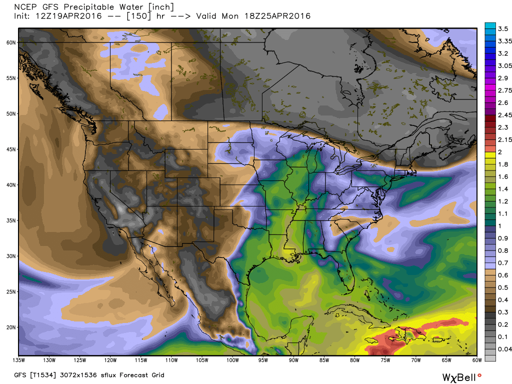
The storm system that delivered flooding rains to Texas, Oklahoma, and Kansas is on the move. Thankfully this system won’t stall out over our region. Thus, we are not expecting anything like areas to our west experienced. Parts of Texas picked up 5″‘-16″ of rain. Amazing totals.
For our region, showers will be on the increase Wednesday and Wednesday night. The bulk of our rainfall will arrive Wednesday night into Thursday evening. A few thunderstorms are also possible. I am not anticipating severe weather. That is the good news.
A cold front will swing through our region on Thursday and Thursday night. A few showers will remain behind the front.
Rainfall totals will range from 0.40″-0.80″. I can’t rule out some spots topping one inch. But, that might be the exception. Thunderstorms can always produce locally higher totals.
Interactive City View Radars for the entire region – click here
Let me show you the high resolution WRF guidance from weatherbell.com
This is the future-cast radar. What radar might look like over the coming 48 hours. This is not gospel, but guidance. Meaning, it won’t be exact. Just take away a general idea of what to expect.
The WRF scoots the cold front out of here fairly early on Thursday.
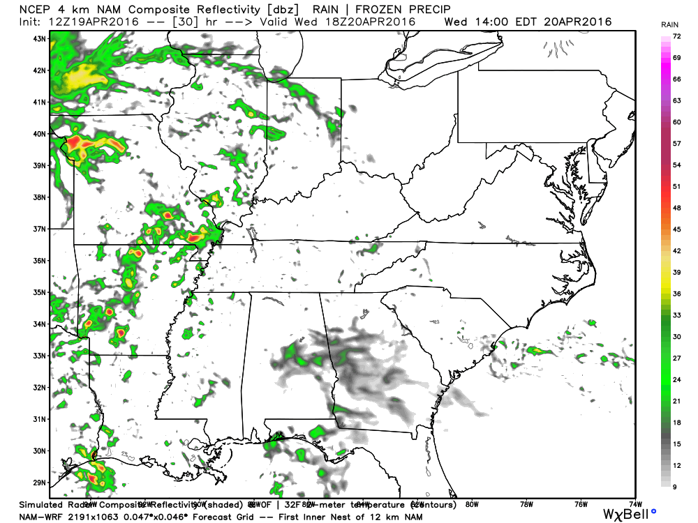
This first image is the future-cast radar for 1 pm on Wednesday. You can see some scattered showers and storms in the area.
This next image is for Wednesday evening (7 pm to be exact). You can see a band of showers/storms in the area. Some heavy downpours, as well.

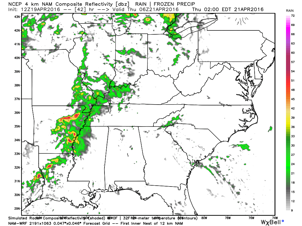
This next image is for Thursday morning at 1 am
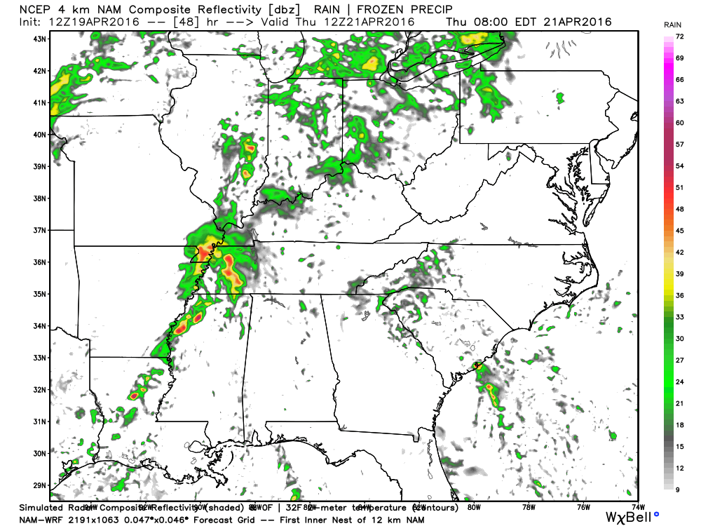
This last image is for Thursday morning at 7 am
The cold front will clear our region by Friday morning. Expect any remaining showers to move eastward by late Thursday night and early Friday morning. At this time, it appears we may still have a few showers on Friday as an upper level low passes over the area.
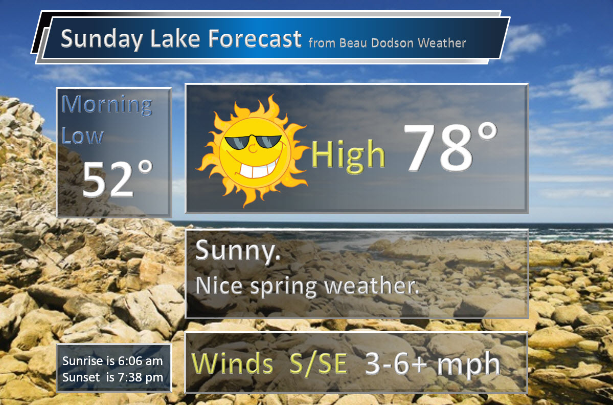
A B E A U T I F U L weekend is anticipated. If everything holds then you can expect widespread 70s on both Saturday and Sunday. Plenty of sunshine, as well. Light winds. Great camping weather on Friday night into Sunday. Great lake weather, as well.
🙂
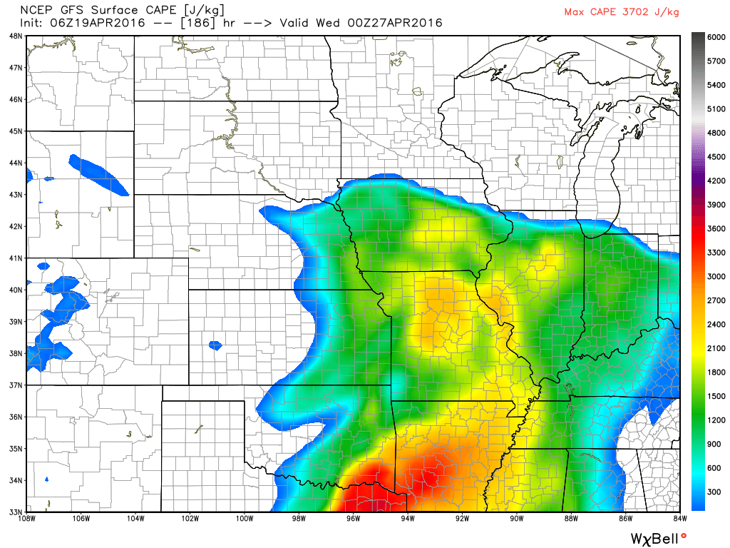
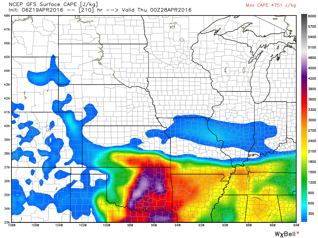
I am monitoring the potential for a stormier pattern next week. Guidance indicates warm and moist air over our region. CAPE (potential energy for thunderstorms) will be on the increase. We have not experienced much CAPE over the last few months. That is one reason we have not had much in the way of severe weather. But, that could change. Let’s keep a close eye on next Tuesday into Thursday.
Let me show you some of the CAPE showing up on the GFS model guidance. The EC guidance is impressive, as well.
What are CAPE values and what do they mean in relation to severe weather? I found a great post about CAPE values and this should explain it. For you go-getter weather enthusiasts – click here
This first image is for Tuesday evening. Quite a bit of CAPE over the region.
This next image, from weatherbell.com, is for Wednesday evening.
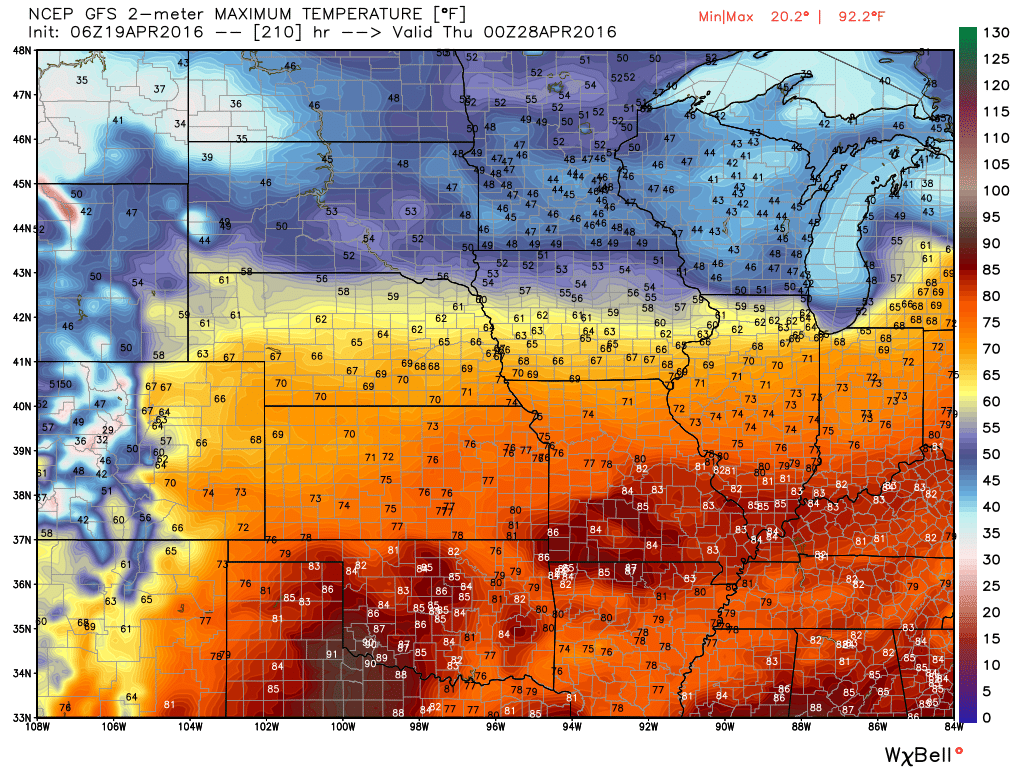
This last image is for Thursday. Notice the sharp boundary? That will need to be monitored. Where there is not CAPE and where there is CAPE is the boundary. You would expect showers and storms along the boundary. How far north or south this boundary will push is questionable. Especially true this far out.
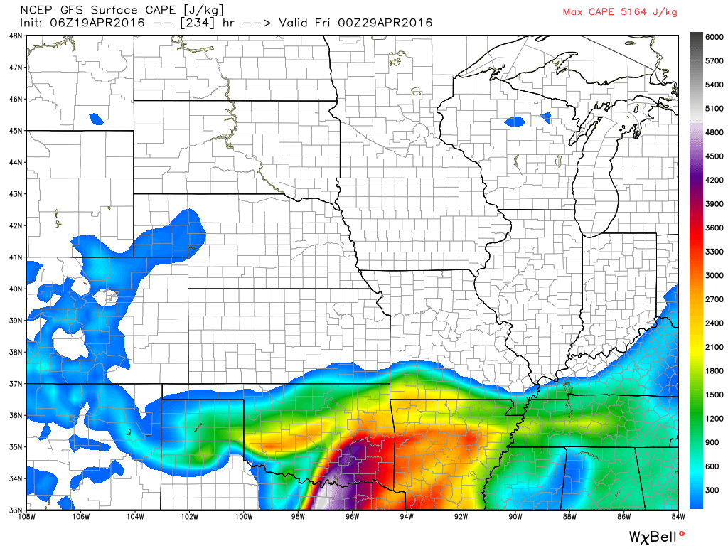
Look at the temperatures for next Thursday. How far north the boundary will push is in question (or south).
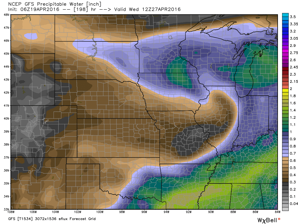
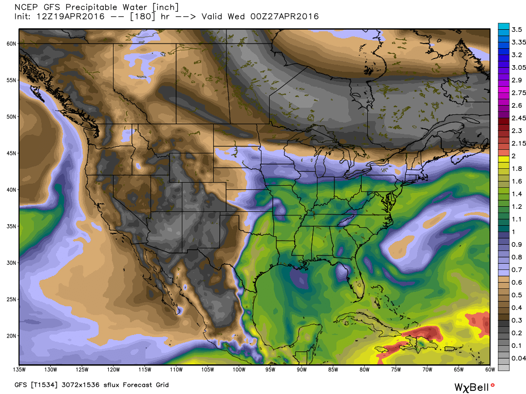
PWAT values (moisture in the entire atmospheric column). This first image is for Wednesday. Notice the curl over Illinois. That would be an area of low pressure. The brown colors represent dry air. The blue and green colors represent quite a bit of moisture. A boundary extends from Illinois into Missouri. Thunderstorms are possible along that boundary. Let’s keep an eye on it. This is for Wednesday, April 27th. Learn more about precipitable water values here
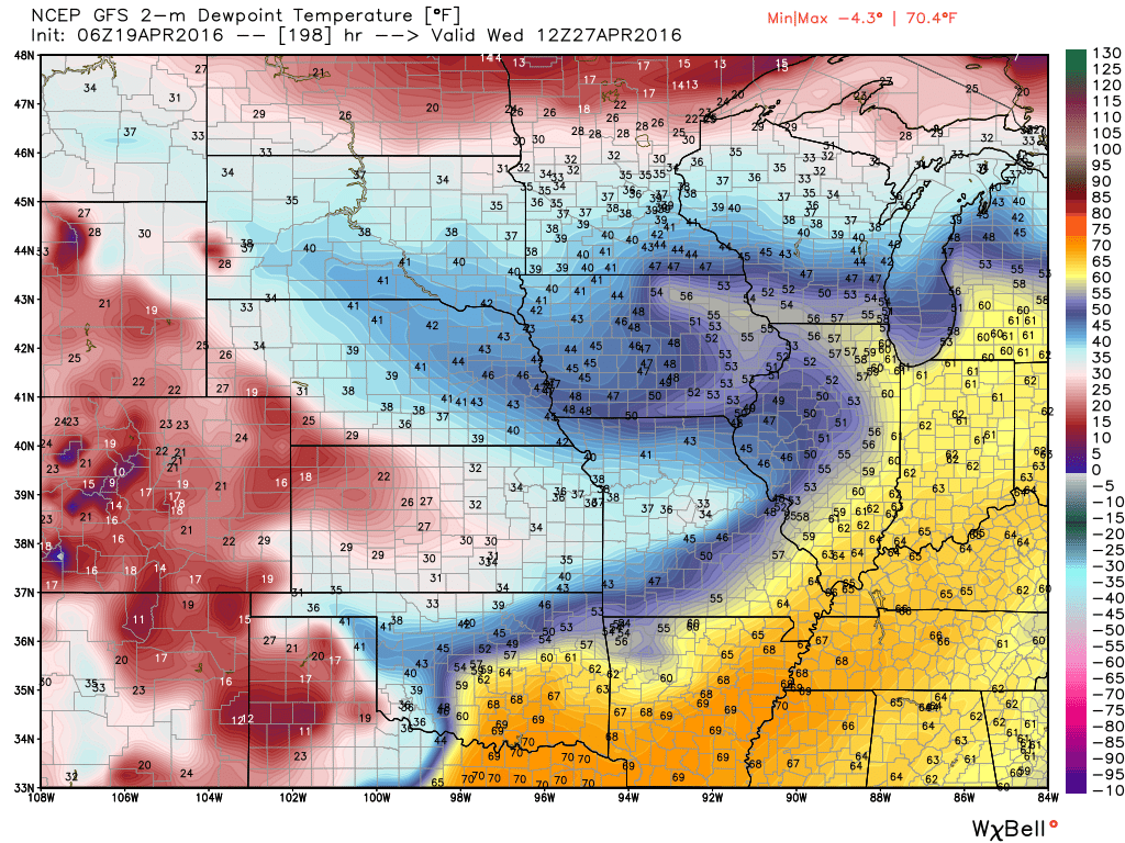
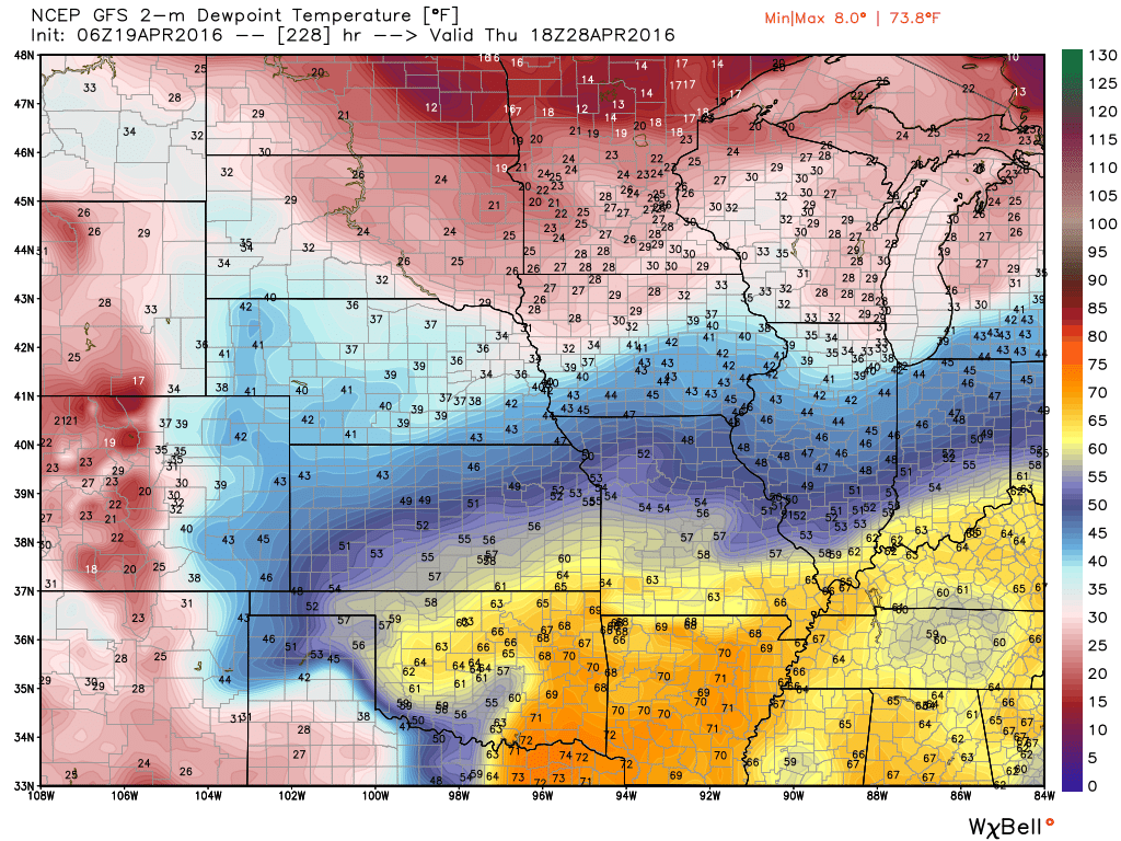
Here are the dew points for next Wednesday and Thursday. You can see the boundary on these maps, as well. Dew points are a great way to measure moisture at ground level. Normally 60 and above are sufficient numbers for thunderstorms. For severe weather I normally monitor for dew points in the lower 60s (or higher).
Click any of these images above or below for larger sizes. You can read them better in the larger sizes.
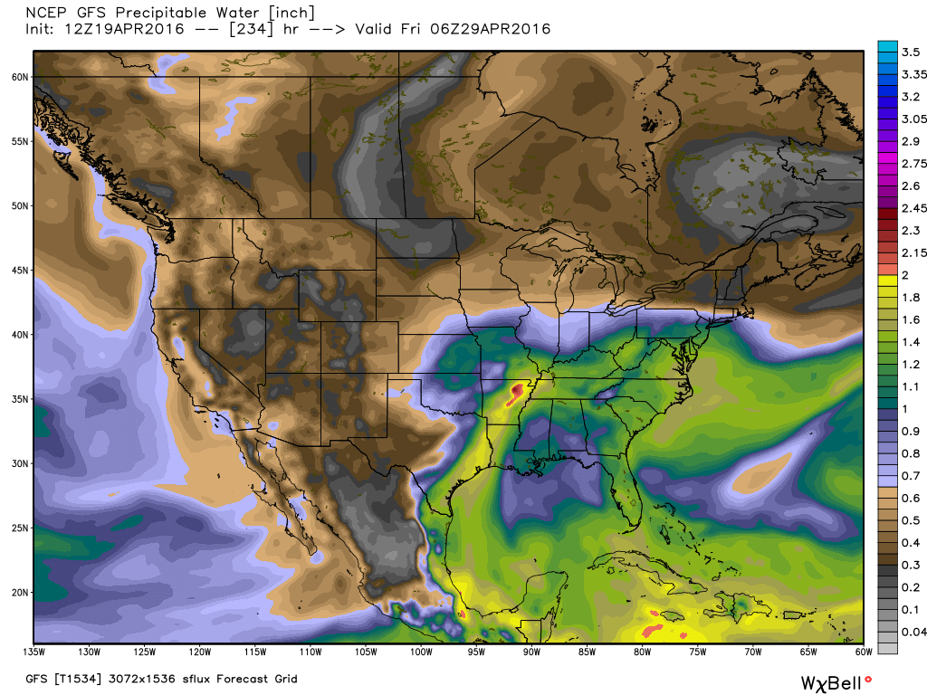
More concerning are the signals for thunderstorms next week into the following week. A lot of the guidance indicates at least some heavy downpours could be a concern over portions of the Missouri, Ohio, and Mississippi Valleys. Strong storms will also be a concern, as well. At least a couple of rounds.
Maya Express next week? Charts are showing something akin to it. Long duration of high PWAT values. We may have to deal with several rounds of storms next week into the following week. Hopefully not stalls out. If something were to stall out then it would have plenty of moisture to work with. As it stands it appears that a series of low pressure centers will push through the Central United States next week and the week after.
As it stands we will at least have a couple of rounds of showers and possibly heavy thunderstorms next week into next weekend. And, perhaps into the following week. Charts show a few systems moving through the moist Gulf of Mexico flow. As long as they keep moving it should prevent extreme rainfall totals in our region.
Long periods of high PWAT values showing up on the GFS model guidance. That is a signal for some heavy rain.
The bottom line, for next week into the following week, is that some locally heavy showers and thunderstorms could occur in and near our region. And, perhaps some strong storms, as well.
What is the Maya Express? Read more about it – here
Monday afternoon
Monday afternoon
Tuesday night
Wednesday afternoon

Thursday – Friday
For now, let’s look forward to a great weekend.

NOTICE on Credit Card statements for WeatherTalk. A number of cards were NOT charged in February and March. Your statement will say pending. You were never charged. Today all of the cards finally processed. It is possible that if you were not charged in February or March that you will see three charges this month. February, March, and April. I apologize for the issues.
You were only charged once. Even though the “PENDING” charge would have shown up on previous statements. It was never processed.
Today it was processed.
If you signed up for monthly then it is possible you will see February, March, and April’s charges on this months statement. But, again you were never charged previously.
There was an error card in the batches and it caused all transactions on three separate days (in February and March) to be kicked out of the system. Thus, you were never charged.
I have had a couple of people ask me about this. Thinking they were charged multiple times. The only people who would see multiple charges are the ones with a monthly billing plan.
Anyone who paid up front for an entire year was only charged once. Again, you might see pending on previous statements. But, pending means you were not charged.
If you have any concerns then private message me.
Thank you and sorry for any confusion or inconvenience.
Beau

Can we expect severe thunderstorms over the next 24 to 48 hours? Remember that a severe thunderstorm is defined as a thunderstorm that produces 58 mph winds or higher, quarter size hail or larger, and/or a tornado.
.
Widespread severe weather is not anticipated through this week.
.
Tuesday night: Maybe a thunderstorm over mainly southeast Missouri. Small chances elsewhere
Wednesday: Showers are possible. I can’t rule out lightning. No severe weather.
Wednesday night: Thursday night: Showers and thunderstorms are possible. Lightning is the only concern.
Friday – Sunday: Severe weather is not anticipated.
Monday – Severe weather is not anticipated.
Tuesday – Thursday of next week you should monitor updates. Some stronger storms possible.
.
.

.
No major changes. I did adjust wind direction for Thursday and Friday. Tweaked temperatures slightly. Otherwise, no significant shifts in this forecast update.

.
I don’t have any major concerns. Lightning will be possible Tuesday night into Thursday evening. Perhaps best chances for lightning would be Wednesday and Thursday. Severe weather is not anticipated.
I am monitoring next week for heavier storms. Stay tuned.
.


How much precipitation should we expect over the next few days?
.
A few showers are possible on Tuesday night into Wednesday. Widespread showers and some thunderstorms are anticipated for Wednesday night into Thursday night. Generally the region can anticipate 0.40″-0.80″ of rainfall. And, spots above one inch are possible. Locally heavier totals can always occur in thunderstorms.
Here is the latest rainfall map from the WPC. This is broad-brushed. But, you get the general idea. Click this weatherbell.com image for a larger view.


Here are the current river stage forecasts. You can click your state and then the dot for your location. It will bring up the full forecast and hydrograph.
.
.

Here is the official 6-10 day and 8-14 day temperature and precipitation outlook. Check the date stamp at the top of each image (so you understand the time frame).
The forecast maps below are issued by the Weather Prediction Center (NOAA).


The latest 8-14 day temperature and precipitation outlook. Note the dates are at the top of the image. These maps DO NOT tell you how high or low temperatures or precipitation will be. They simply give you the probability as to whether temperatures or precipitation will be above or below normal.


Who do you trust for your weather information and who holds them accountable?
I have studied weather in our region since the late 1970’s. I have 37 years of experience in observing our regions weather patterns. My degree is in Broadcast Meteorology from Mississippi State University and an Associate of Science (AS). I am currently working on my Bachelor’s Degree in Geoscience.
My resume includes:
Member of the American Meteorological Society.
NOAA Weather-Ready Nation Ambassador.
Meteorologist for McCracken County Emergency Management. I served from 2005 through 2015.
I own and operate the Southern Illinois Weather Observatory.
Recipient of the Mark Trail Award, WPSD Six Who Make A Difference Award, Kentucky Colonel, and the Caesar J. Fiamma” Award from the American Red Cross.
In 2009 I was presented with the Kentucky Office of Highway Safety Award.
Recognized by the Kentucky House of Representatives for my service to the State of Kentucky leading up to several winter storms and severe weather outbreaks.
I am also President of the Shadow Angel Foundation which serves portions of western Kentucky and southern Illinois.
There is a lot of noise on the internet. A lot of weather maps are posted without explanation. Over time you should learn who to trust for your weather information.
My forecast philosophy is simple and straight forward.
- Communicate in simple terms
- To be as accurate as possible within a reasonable time frame before an event
- Interact with you on Twitter, Facebook, and the blog
- Minimize the “hype” that you might see on television or through other weather sources
- Push you towards utilizing wall-to-wall LOCAL TV coverage during severe weather events
I am a recipient of the Mark Trail Award, WPSD Six Who Make A Difference Award, Kentucky Colonel, and the Caesar J. Fiamma” Award from the American Red Cross. In 2009 I was presented with the Kentucky Office of Highway Safety Award. I was recognized by the Kentucky House of Representatives for my service to the State of Kentucky leading up to several winter storms and severe weather outbreaks.
If you click on the image below you can read the Kentucky House of Representatives Resolution.

Many of my graphics are from www.weatherbell.com – a great resource for weather data, model data, and more


You can sign up for my AWARE email by clicking here I typically send out AWARE emails before severe weather, winter storms, or other active weather situations. I do not email watches or warnings. The emails are a basic “heads up” concerning incoming weather conditions.