We have some great sponsors for the Weather Talk Blog. Please let our sponsors know that you appreciate their support for the Weather Talk Blog.
Milner and Orr Funeral Home and Cremation Services located in Paducah, Kentucky and three other western Kentucky towns – at Milner and Orr they believe in families helping families. You can find Milner and Orr on Facebook, as well.
![]()
.

For all of your families eye care needs. Visit their web-site here. Or, you can also visit their Facebook page.
.

Best at Enabling Body Shop Profitability since 1996. Located In Paducah Kentucky and Evansville Indiana; serving all customers in between. They provide Customer Service, along with all the tools necessary for body shops to remain educated and competitive. Click the logo above for their main web-site. You can find McClintock Preferred Finishes on Facebook, as well

Expressway Carwash and Express Lube are a locally owned and operated full service Carwash and Lube established in 1987. We have been proudly serving the community for 29 years now at our Park Avenue location and 20 years at our Southside location. We have been lucky enough to partner with Sidecar Deli in 2015, which allows us to provide our customers with not only quality service, but quality food as well. . If you haven’t already, be sure to make Expressway your one stop shop, with our carwash, lube and deli. For hours of operation and pricing visit www.expresswashlube.com or Expressway Carwash on Facebook.

TORNADO SHELTERS! Endrizzi’s Storm Shelters – For more information click here. Endrizzi Contracting and Landscaping can be found on Facebook, as well – click here
I have launched the new weather texting service! I could use your help. Be sure and sign up and fully support all of the weather data you see each day.
This is a monthly subscription service. Supporting this helps support everything else. The cost is $3 a month for one phone, $5 a month for three phones, and $10 a month for seven phones.
For more information visit BeauDodsonWeather.com
Or directly sign up at Weathertalk.com


This forecast update covers far southern Illinois, far southeast Missouri, and far western Kentucky. See the coverage map on the right side of the blog.
Remember that weather evolves. Check back frequently for updates, especially during active weather.

FROST FORECAST:
Frost update for the orchards/others.
Friday night – 40% chance for frost for northern half of southeast Missouri and northern half of southern Illinois. That would include Cape Girardeau to Carmi, Illinois northward.
South of that line there is a 30% chance for frost.
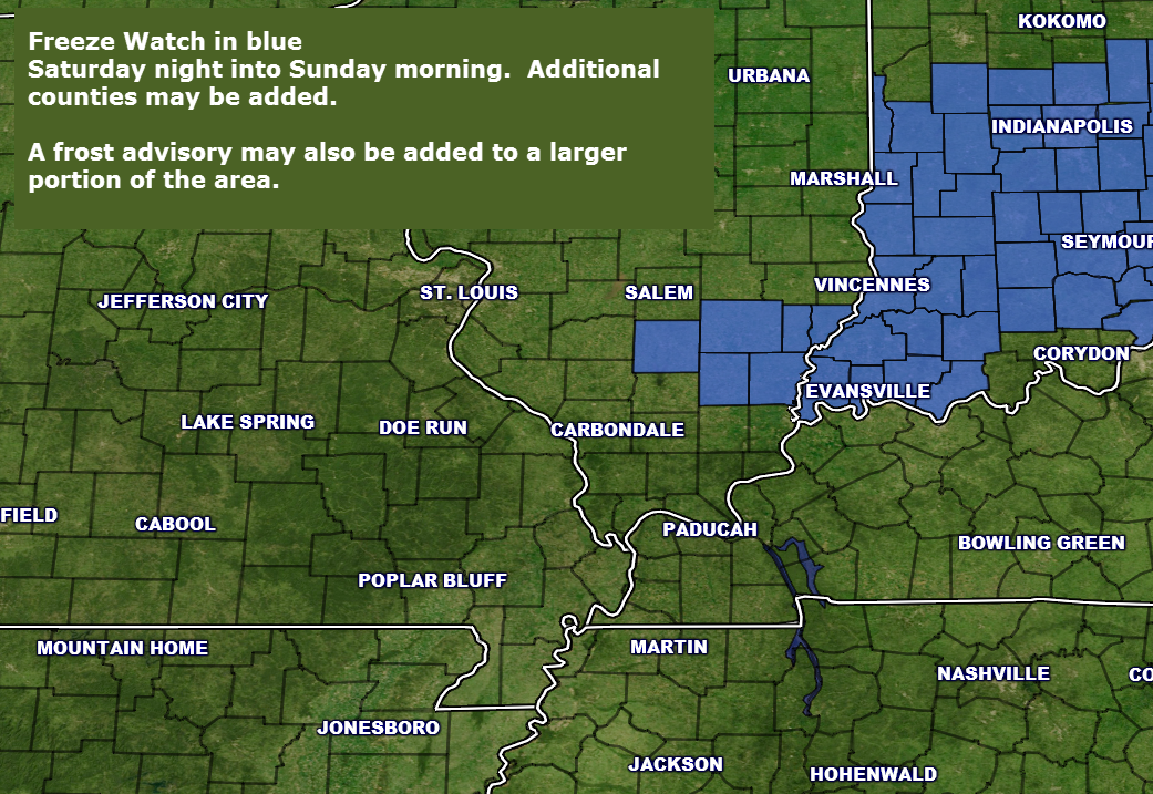
Saturday night there is a 60% chance for frost over southeast Missouri, southern Illinois, western Kentucky, and northwest Tennessee.
Saturday night – There is a 40% chance for a freeze over the northern half of southeast Missouri, all of southern Illinois, and northwest Kentucky.
Winds could be the deciding factor both Saturday and Sunday night as to whether frost occurs. Winds stay up and frost risk decreases.
Sunday night – no frost anticipated.
Monday night – There is a 50% chance for frost area wide.
Tuesday night – Frost is not anticipated
Wednesday night – Not concerned about frost.
Thursday night – Frost is possible.
Friday Night – Some evening clouds. Clearing late. Cold. Frost possible if winds die down.
Temperatures: Lows in the middle to upper 30s
Winds: Light winds from the northwest
What is the chance for precipitation? 0%
Coverage of precipitation? None
My confidence in this part of the forecast verifying is High
Should I be concerned about snow or ice? No
Should I cancel my outdoor plans? No
Is severe weather expected? No
What impact is expected? A chance for frost. Frost conditions will be determined by wind speed. If winds stay up then frost risk decreases.
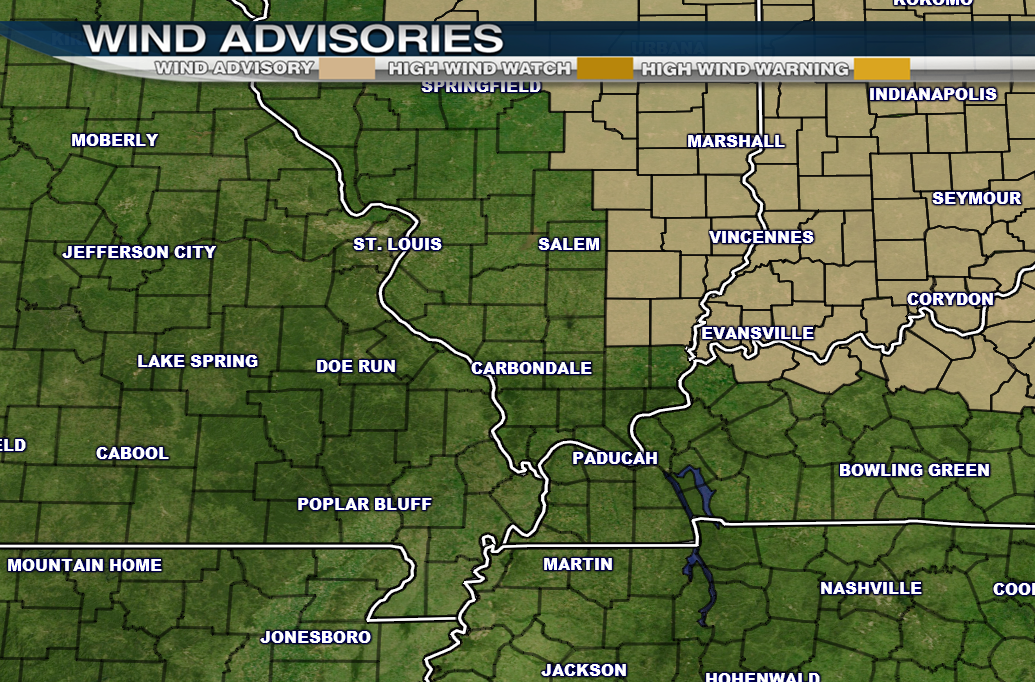
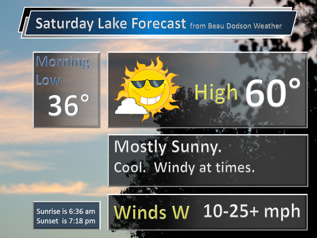
Saturday – Mostly sunny and cool. Some clouds possible in the afternoon as a cold front moves into the area. Windy, at times. Highest winds will be over southern Illinois and northwest Kentucky.
Temperatures: High temperatures in the upper 50s to lower 60s. Warmest over southeast Missouri.
Winds: West/northwest winds at 10-25 mph. Winds may gust over 35-40 mph during the afternoon hours. Especially over southern Illinois and northwest Kentucky.
What is the chance for precipitation? 10% over our northeast counties (SE IL and NW KY)
Coverage of precipitation? None to isolated. Small chance for a shower over southeast IL and northwest KY.
My confidence in this part of the forecast verifying is High
Should I be concerned about snow or ice? No
Should I cancel my outdoor plans? No
Is severe weather expected? No
What impact is expected? Strong winds possible.
Saturday Night – Mostly clear and cold. Frost and/or freeze possible. Monitor updates.
Temperatures: Lows in the lower to middle 30s
Winds: West and northwest winds at 10-20 mph early. Diminishing to less than 5 mph late.
What is the chance for precipitation? 0%
Coverage of precipitation? None
My confidence in this part of the forecast verifying is Medium
Should I be concerned about snow or ice? No
Should I cancel my outdoor plans? No
Is severe weather expected? No
What impact is expected? Frost possible. Freeze possible.
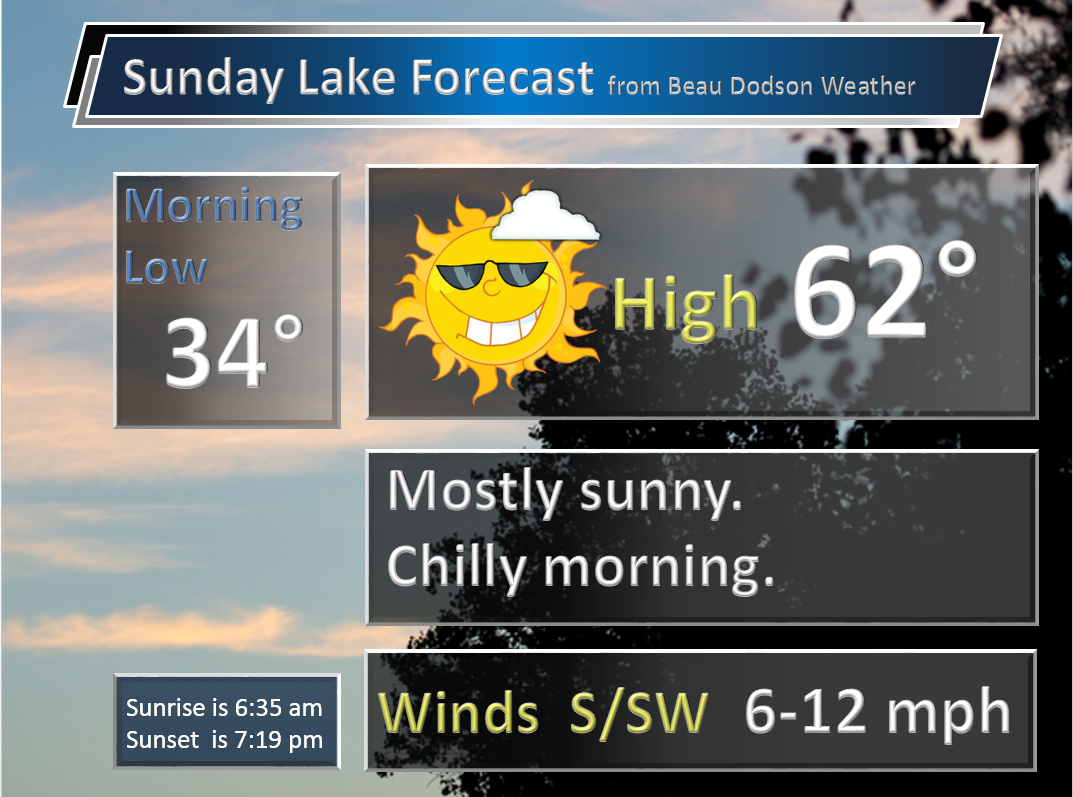
Sunday – Partly cloudy.
Temperatures: High temperatures in the 56-62 degree range. I went a little low on Sunday highs. Data is mixed on whether we go above 60 degrees.
Winds: Southwest and west winds at 5 mph. Variable winds in the afternoon. Turning more southerly.
What is the chance for precipitation? 0%
Coverage of precipitation? None
My confidence in this part of the forecast verifying is High
Should I be concerned about snow or ice? No
Should I cancel my outdoor plans? No
Is severe weather expected? No
What impact is expected? None
Sunday Night – Mostly clear and not as cold.
Temperatures: Lows in the middle 40s
Winds: South and southwest winds at 5 mph
What is the chance for precipitation? 0%
Coverage of precipitation? None
My confidence in this part of the forecast verifying is High
Should I be concerned about snow or ice? No
Should I cancel my outdoor plans? No
Is severe weather expected? No
What impact is expected? None
Monday – Partly sunny. A small chance for an afternoon/evening shower.
Temperatures: High temperatures in the 64 to 68 degree range. Pockets of 70 degrees possible over southeast Missouri.
Winds: Southwest and west winds at 5 mph. Winds becoming northwest behind the cold front.
What is the chance for precipitation? 20%
Coverage of precipitation? Isolated late in the day
My confidence in this part of the forecast verifying is High
Should I be concerned about snow or ice? No
Should I cancel my outdoor plans? No
Is severe weather expected? No
What impact is expected? None
Monday Night – Mostly clear and cold. Frost and or freeze possible.
Temperatures: Lows in the lower 30s.
Winds: Light winds
What is the chance for precipitation? 0%
Coverage of precipitation? None
My confidence in this part of the forecast verifying is High
Should I be concerned about snow or ice? No
Should I cancel my outdoor plans? No
Is severe weather expected? No
What impact is expected? Frost and/or freeze
Tuesday – Mostly sunny. Colder.
Temperatures: High temperatures in the 50s
Winds: Light and variable winds.
What is the chance for precipitation? 0%
Coverage of precipitation? None
My confidence in this part of the forecast verifying is High
Should I be concerned about snow or ice? No
Should I cancel my outdoor plans? No
Is severe weather expected? No
What impact is expected? None
The School Bus Stop Forecast is sponsored by Heath Health and Wellness. Located next to Crowell Pools in Lone Oak, Kentucky.
Visit their web-site here. And. visit Heath Health Foods on Facebook!
The School Bus Stop Forecast is sponsored by Heath Health and Wellness. Located next to Crowell Pools in Lone Oak.

Heath Health Foods is a locally owned and operated retail health and wellness store. Since opening in February 2006; the store has continued to grow as a ministry with an expanding inventory which also offers wellness appointments and services along with educational opportunities. Visit their web-site here. And. visit Heath Health Foods on Facebook!

Don’t forget to check out the Southern Illinois Weather Observatory web-site for weather maps, tower cams, scanner feeds, radars, and much more! Click here

An explanation of what is happening in the atmosphere over the coming days…
- Cam weather for the weekend
- Windy Saturday
- Frost potential?
- Rain by the middle of the week?
After a stormy week I think we have earned a few quiet days. We had tornadoes on Easter Sunday. We had several reports of damage on Thursday. April Fools, however, was calm. And, calm is what we like.
We do have some weather concerns over the next five to seven days. The main concern will be frost.
There are several deciding factors as to whether or not frost forms tonight. The main factor will be winds. If winds stay up a bit then we won’t have to deal with frost. But, if the winds do become calm then frost chances go up.
The coldest air is likely to be over the northern half of southeast Missouri and southern Illinois. Perhaps northwest Kentucky, as well. I drew a line from Cape Girardeau, Missouri towards Marion, Kentucky. Along and north of that line there could be some frost. That is where the best chances will be placed. South of there will still have a chance for frost, but not as great.
Saturday will deliver cool temperatures and strong winds. Winds on Saturday afternoon could gust above 35 mph. Especially true for southern Illinois and northwest Kentucky.
And, by Saturday night a frost or freeze will be possible in the region. If you have sensitive plants then there could be problems. Temperatures could drop into the lower 30s. Not sure anyone dips into the upper 20s, but that will need to be monitored, as well.
Another cold front pushes through the region on Monday. Some clouds and a light shower possible Monday afternoon and then another dump of cold air. A frost or freeze will be possible on Monday night, as well.
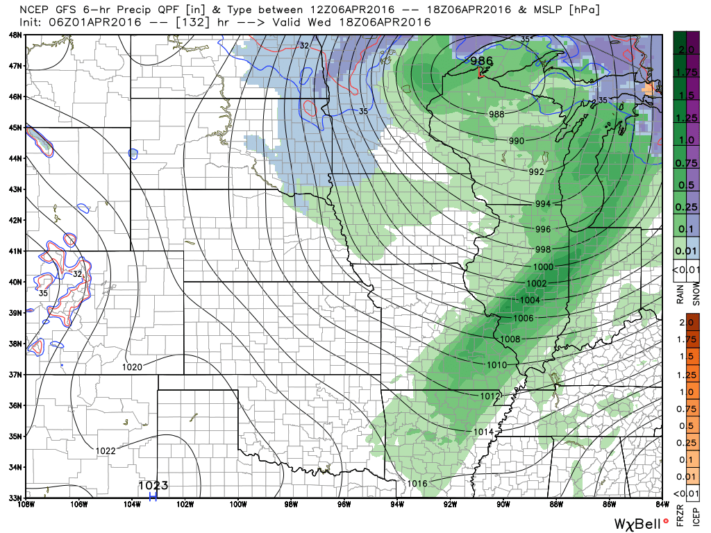
Showers and thunderstorms will be in the forecast for next Wednesday. A cold front sweeps through the area with clouds and rain. Still a bit early to know if severe weather will be a concern.
Here is what the GFS is showing for next Wednesday. The green represents rain and storms. Deep low over northern Wisconsin. Tight pressure gradient. Windy conditions for our region, as well.
Another cold shot arrives next Thursday night. More frost or freeze conditions could occur during that time frame. We obviously are not finished with cold temperatures.
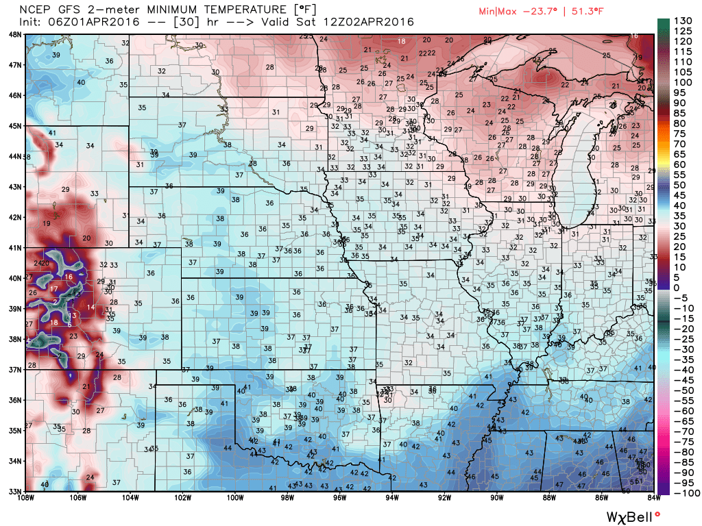
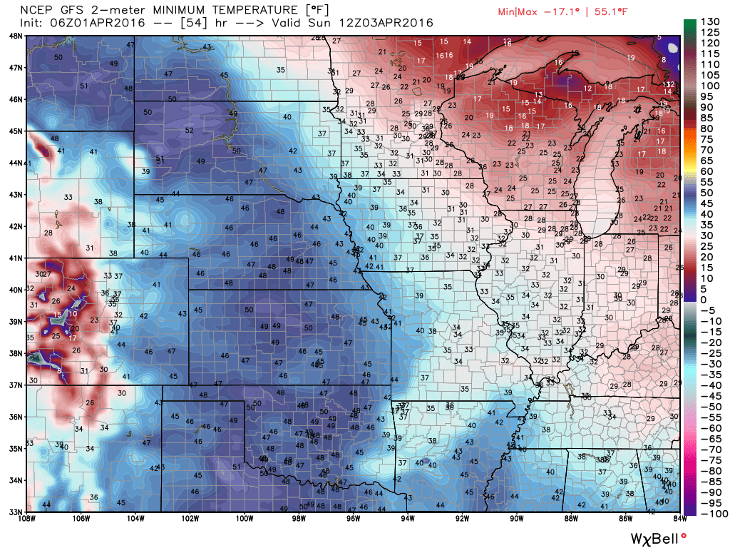
Let me show you the GFS low temperature forecasts. This won’t be exact. But, I just wanted to give you an idea of just how much cold air is still in the charts.
This first map is for Saturday morning.
Again, it won’t be exact. But, you get the general idea.
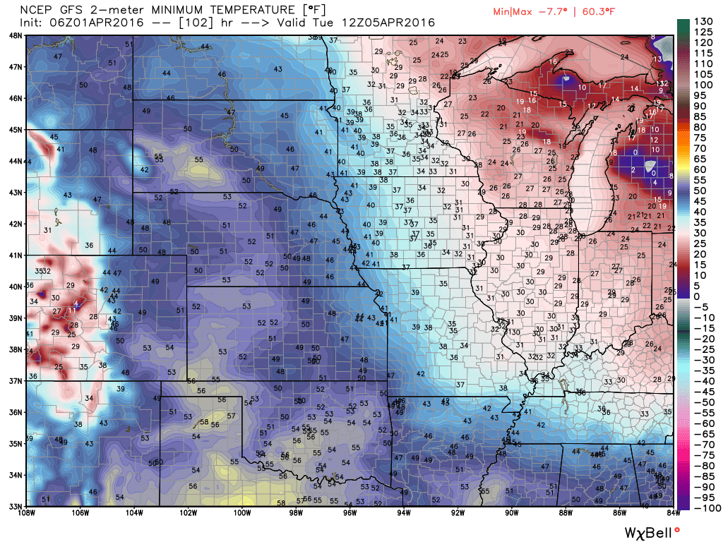
Here is the Sunday morning low temperature forecast
Here is the Tuesday morning low temperature forecast
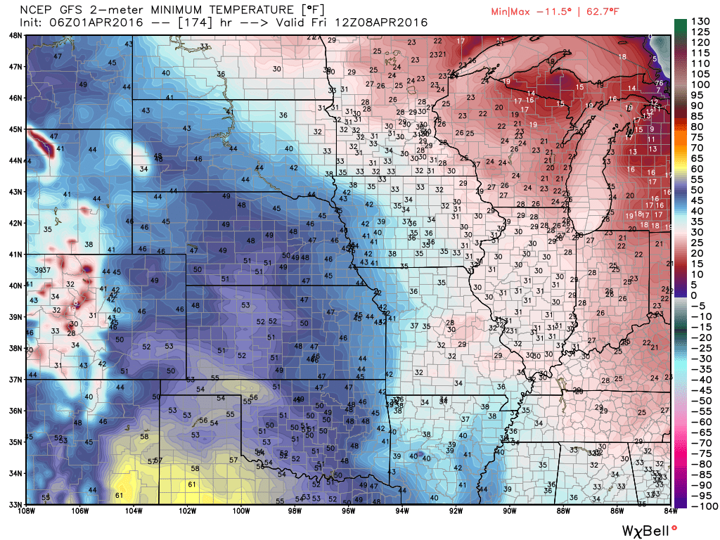
Here is next Friday mornings low temperature forecast
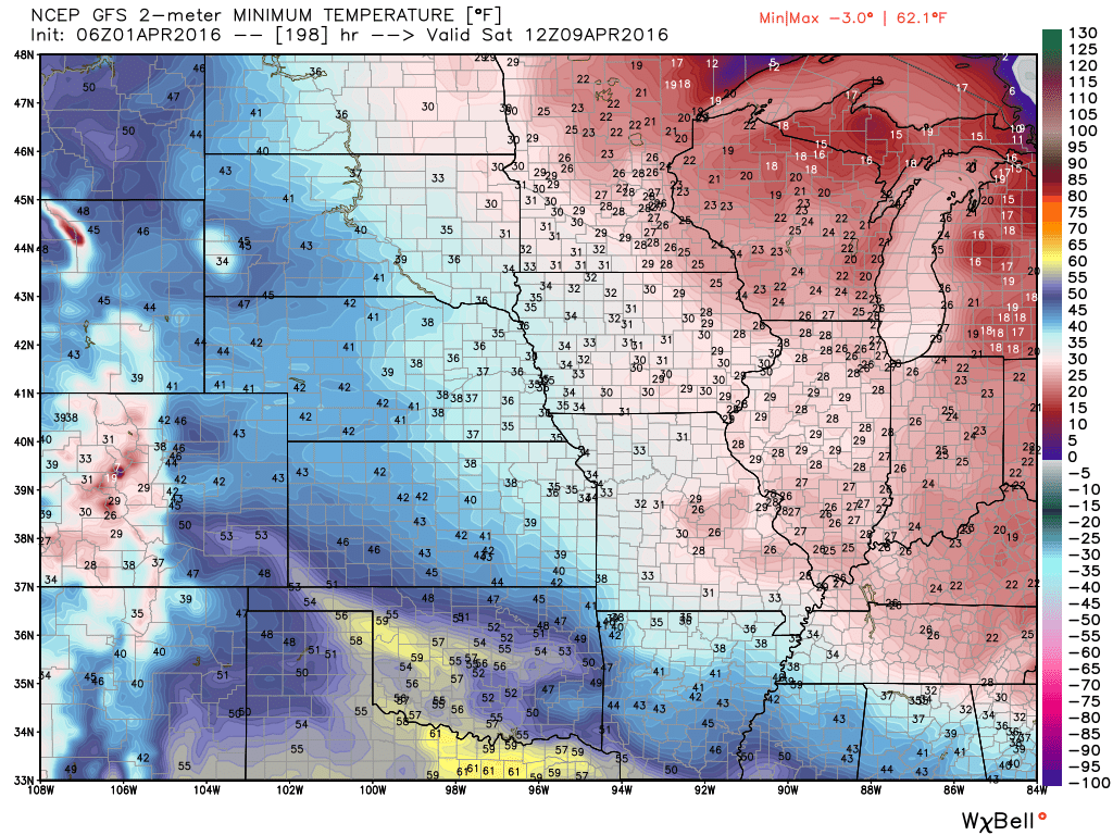
Here is the low temperature forecast for NEXT Saturday morning

Can we expect severe thunderstorms over the next 24 to 48 hours? Remember that a severe thunderstorm is defined as a thunderstorm that produces 58 mph winds or higher, quarter size hail or larger, and/or a tornado.
.
No thunderstorms expected through Sunday afternoon.
.

Updated wind speeds and temperatures.
.

Watching for frost on Saturday and Sunday morning. Wind speed will determine whether frost is a concern for Saturday morning. If winds stay up then frost risk goes down.40% chance for frost Saturday morning
Frost update for the orchards/others.
Friday night – 40% chance for frost for northern half of southeast Missouri and northern half of southern Illinois. That would include Cape Girardeau to Carmi, Illinois northward.
South of that line there is a 30% chance for frost.
Saturday night there is a 60% chance for frost over southeast Missouri, southern Illinois, western Kentucky, and northwest Tennessee.
Saturday night – There is a 40% chance for a freeze over the northern half of southeast Missouri, all of southern Illinois, and northwest Kentucky.
Winds could be the deciding factor both Saturday and Sunday night as to whether frost occurs. Winds stay up and frost risk decreases.
Sunday night – no frost anticipated.
Monday night – There is a 50% chance for frost area wide.
Tuesday night – Frost is not anticipated
Wednesday night – Not concerned about frost.
Thursday night – Frost is possible.

Monitor for frost potential Saturday and Sunday morning.

How much precipitation should we expect over the next few days?
Dry weather anticipated through Sunday.

Here are the current river stage forecasts. You can click your state and then the dot for your location. It will bring up the full forecast and hydrograph.

Here is the official 6-10 day and 8-14 day temperature and precipitation outlook. Check the date stamp at the top of each image (so you understand the time frame).
The forecast maps below are issued by the Weather Prediction Center (NOAA).


The latest 8-14 day temperature and precipitation outlook. Note the dates are at the top of the image. These maps DO NOT tell you how high or low temperatures or precipitation will be. They simply give you the probability as to whether temperatures or precipitation will be above or below normal.


Who do you trust for your weather information and who holds them accountable?
I have studied weather in our region since the late 1970’s. I have 37 years of experience in observing our regions weather patterns. My degree is in Broadcast Meteorology from Mississippi State University and an Associate of Science (AS). I am currently working on my Bachelor’s Degree in Geoscience.
My resume includes:
Member of the American Meteorological Society.
NOAA Weather-Ready Nation Ambassador.
Meteorologist for McCracken County Emergency Management. I served from 2005 through 2015.
I own and operate the Southern Illinois Weather Observatory.
Recipient of the Mark Trail Award, WPSD Six Who Make A Difference Award, Kentucky Colonel, and the Caesar J. Fiamma” Award from the American Red Cross.
In 2009 I was presented with the Kentucky Office of Highway Safety Award.
Recognized by the Kentucky House of Representatives for my service to the State of Kentucky leading up to several winter storms and severe weather outbreaks.
I am also President of the Shadow Angel Foundation which serves portions of western Kentucky and southern Illinois.
There is a lot of noise on the internet. A lot of weather maps are posted without explanation. Over time you should learn who to trust for your weather information.
My forecast philosophy is simple and straight forward.
- Communicate in simple terms
- To be as accurate as possible within a reasonable time frame before an event
- Interact with you on Twitter, Facebook, and the blog
- Minimize the “hype” that you might see on television or through other weather sources
- Push you towards utilizing wall-to-wall LOCAL TV coverage during severe weather events
I am a recipient of the Mark Trail Award, WPSD Six Who Make A Difference Award, Kentucky Colonel, and the Caesar J. Fiamma” Award from the American Red Cross. In 2009 I was presented with the Kentucky Office of Highway Safety Award. I was recognized by the Kentucky House of Representatives for my service to the State of Kentucky leading up to several winter storms and severe weather outbreaks.
If you click on the image below you can read the Kentucky House of Representatives Resolution.

Many of my graphics are from www.weatherbell.com – a great resource for weather data, model data, and more


You can sign up for my AWARE email by clicking here I typically send out AWARE emails before severe weather, winter storms, or other active weather situations. I do not email watches or warnings. The emails are a basic “heads up” concerning incoming weather conditions.