

.
I have some question-and-answer threads over on the Facebook page. Link to those threads CLICK HERE
Or email me at beaudodsonweather@gmail.com
.

🌪️ Seven-Day Tornado Outlook ⛈️
April 17th through April 23rd
Current risk: POSSIBLE.
Current confidence level: Medium.
Comment: I am monitoring Friday into Sunday night.
At this time, the tornado risk appears minimal from Friday into Saturday night.
Peak severe weather chances will likely arrive on Sunday afternoon and Sunday night.
If you have outdoor plans this weekend, then monitor updated forecasts. Have a plan B, just in case storms threaten.
.

Seven-Day Hazardous Weather Outlook
1. Is lightning in the forecast? YES. Isolated lightning this morning. Lightning is possible Friday night into Sunday night.
I will monitor next Wednesday.
2. Are severe thunderstorms in the forecast? YES. See the graphics below.
A low-end risk may develop Friday night into Saturday night. A few storms could produce strong wind gusts and hail.
The risk of severe weather will likely be higher on Sunday and Sunday night. This is the period that I am monitoring for a more significant severe weather risk.
There remain questions about Sunday’s setup. The speed of the cold front and the placement of the area of low pressure will influence the severe weather risk.
Monitor updates and radars if you have outdoor plans from Friday night into Sunday night. I would not cancel any plans, but have a plan B in your back pocket. Keep in mind, rain coverage from Friday night into Saturday night will be higher across Missouri and Illinois. See the seven-day video and graphics below.
3. Is flash flooding in the forecast? POSSIBLE. Locally heavy rain is possible this weekend. If heavy rain develops, then some flash flooding could occur. Overall, the flash flood risk is limited. Ongoing river and overland flooding will continue.
The heaviest rain will likely fall from south-central Missouri into northern portions of southern Illinois.
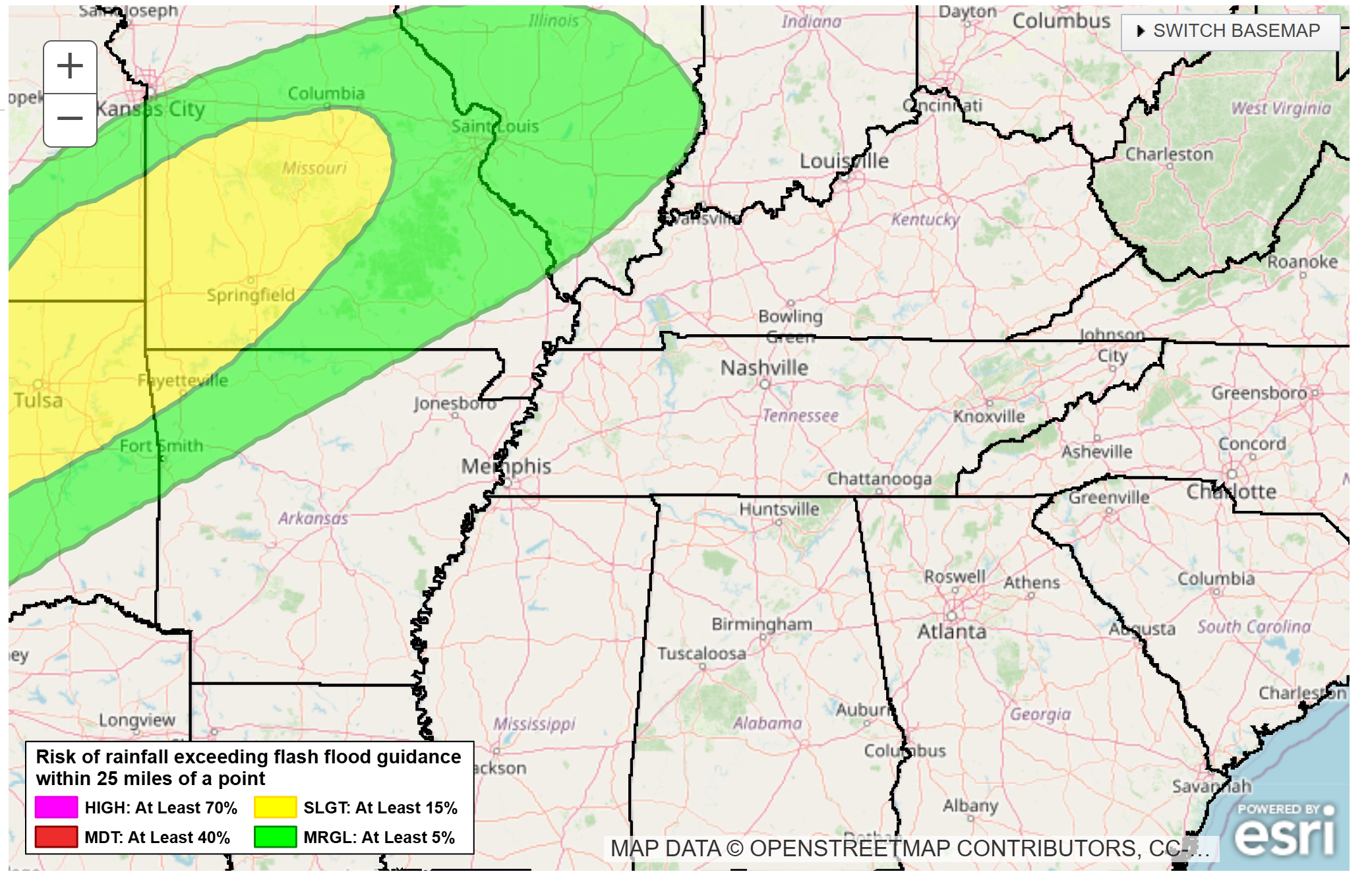
The Weather Prediction Center/NOAA has outlined our region for a risk of flash flooding on Friday and Saturday.
Here is that risk zone. The green is a marginal risk. The yellow is a slight risk of excessive rainfall.
A marginal risk across portions of southeast Missouri and southern Illinois.
.
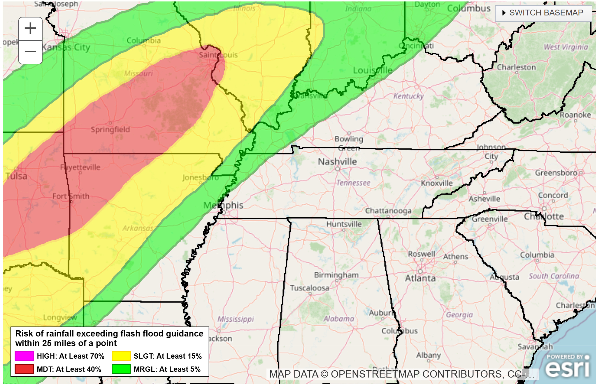
Saturday’s flash flood threat zone.
A marginal and slight risk of flash flooding across portions of southeast Missouri and southern Illinois. That does extend into portions of Kentucky and Tennessee.
.
4. Will non-thunderstorm winds top 40 mph? LOW RISK. Gusty winds are likely on Friday. They could approach 40 mph.
5. Will temperatures rise above 90 degrees? NO.
6. Will the heat index rise above 100 degrees? NO.
.
A quick forecast glance. Your 48-hour forecast Graphics


.

.


Forecast discussion.
- A few showers this morning. Clearing sky conditions through the day.
- Gusty winds on Friday.
- Increasing shower and thunderstorm chances Friday afternoon into Sunday night. A wide range of rain probabilities over the coming days. See graphics below.
- A few storms could be intense this weekend. Locally heavy downpours.
- Peak severe weather chances will likely arrive on Sunday afternoon and night. Monitor updates.
.

.
Major flooding continues in some counties.
Avoid flooded roadways. Water continues to recede in many areas. Larger rivers, however, continue to rise.
River and lake stages. Forecasts. Click here.
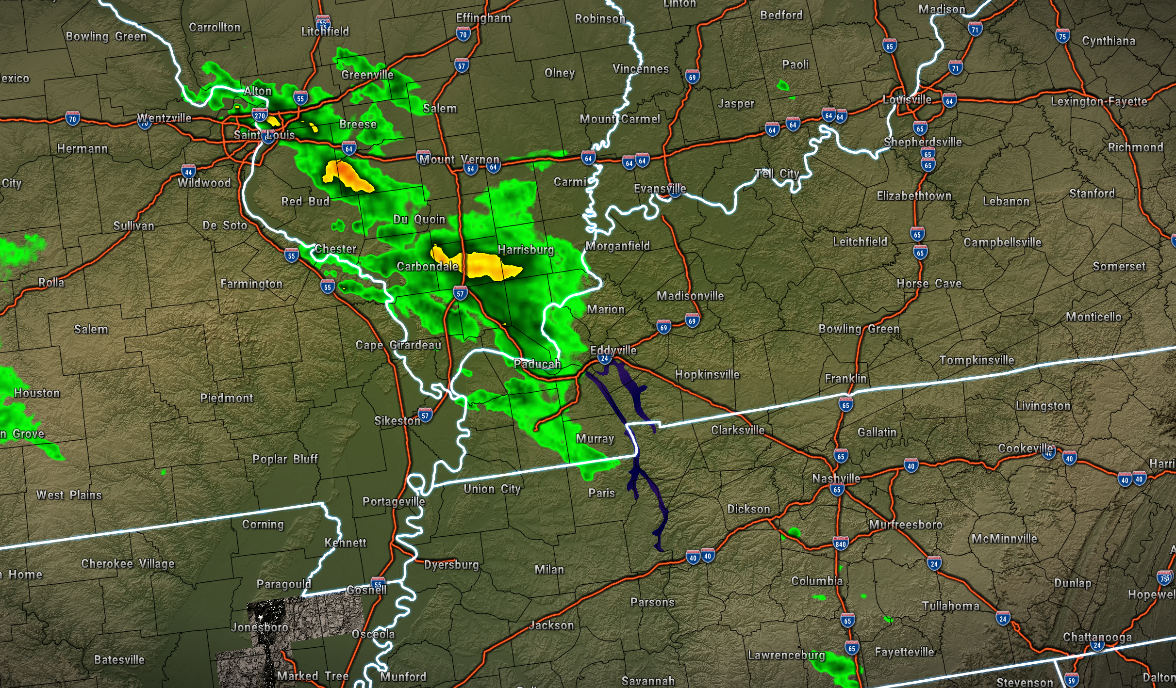
We are waking up to scattered showers and thunderstorms. Mainly over Missouri and Illinois. Less coverage elsewhere.
Here was the 5:30 AM radar snapshot. This was all moving off to the east.
.
As we move through today, the clouds will clear. It will be warm and breezy today.
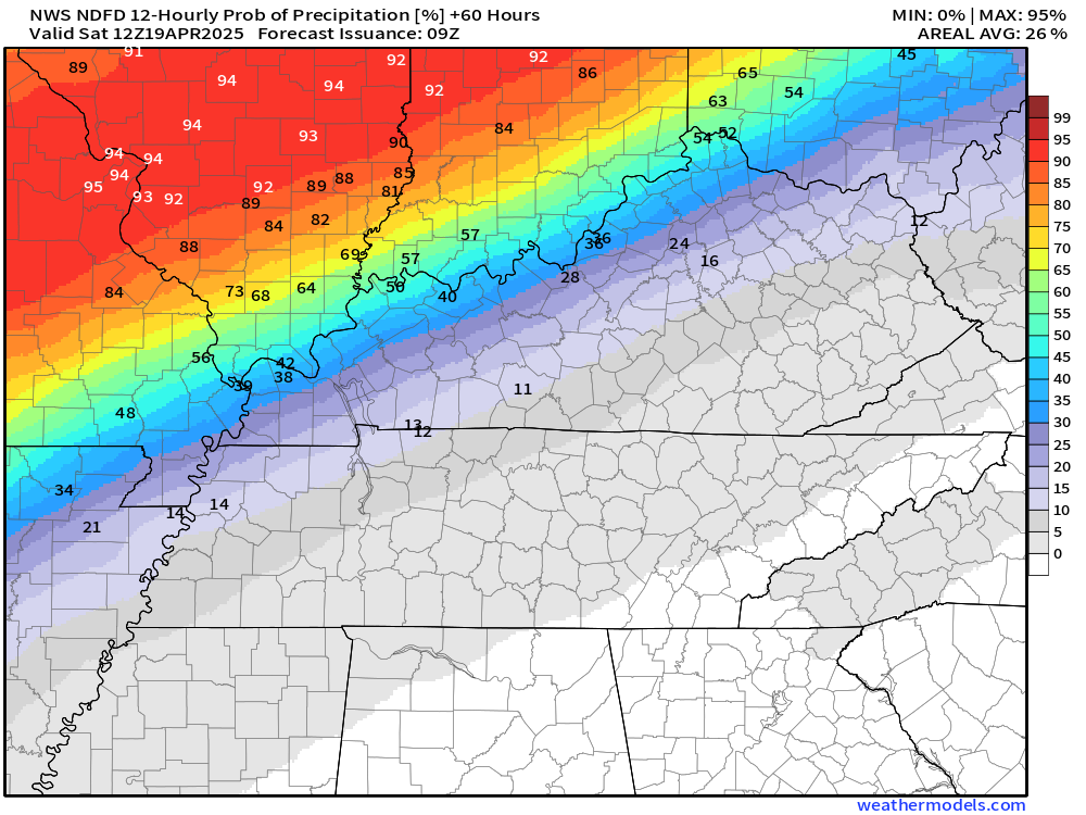
We will have occasional showers and thunderstorms tomorrow afternoon into Sunday night.
There will be a WIDE range of rain probabilities with this event.
Missouri and Illinois will have the highest precipitation coverage tomorrow night into Saturday. Then, chances increase area-wide as we move into Saturday night and Sunday.
Let me show you that in graphical form (I also included this in the video).
If you have outdoor plans, monitor updates and radars. Have a plan B. Then, you will be prepared.
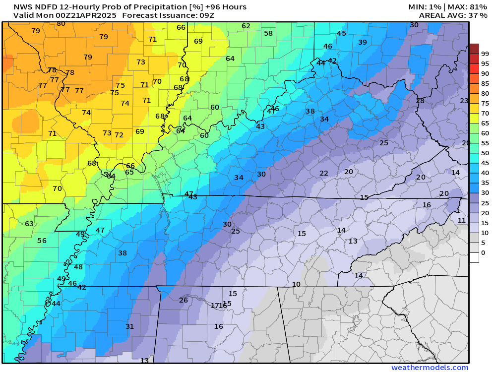
As you can see, the Friday night rain probabilities are higher north-northwest vs south-southeast.
.
Saturday’s rain probabilities. Again, higher over Missouri and Illinois.
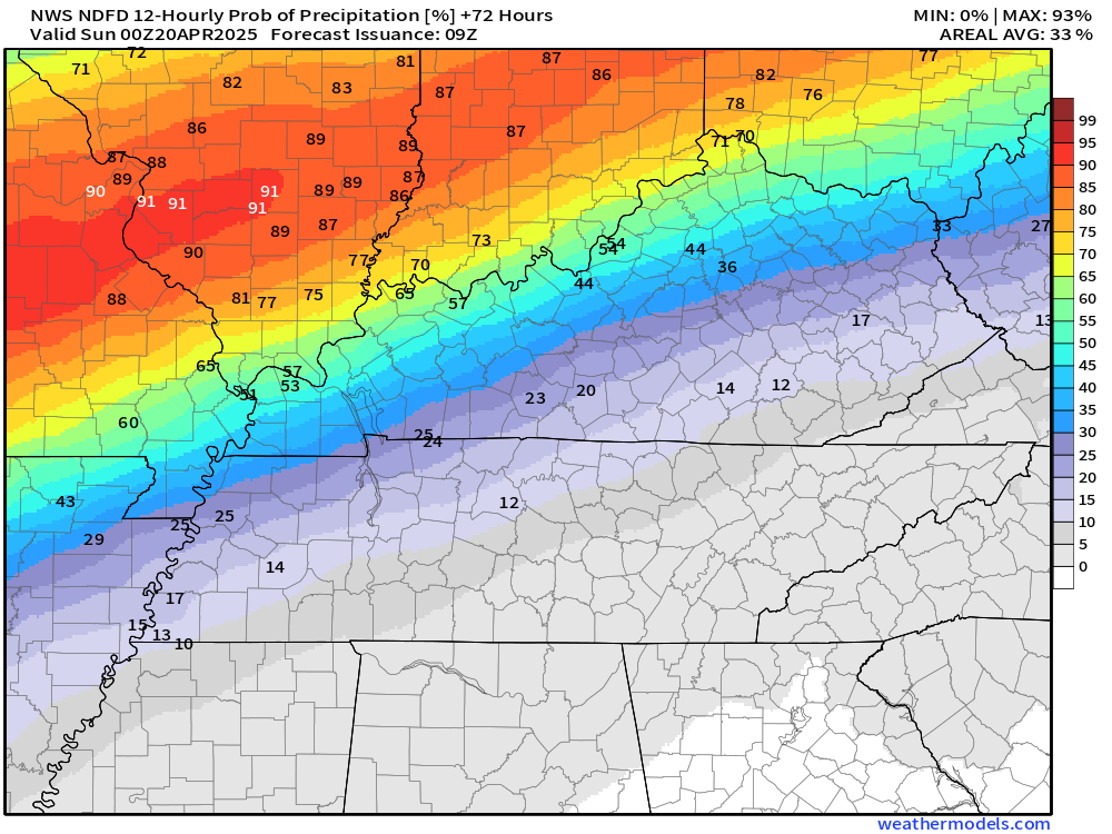
.
Saturday night’s rain probabilities.
.
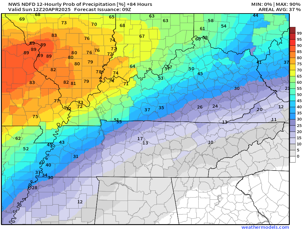
Sunday’s rain probabilities. Some of the storms on Sunday afternoon and night could be severe. Monitor alerts.
.
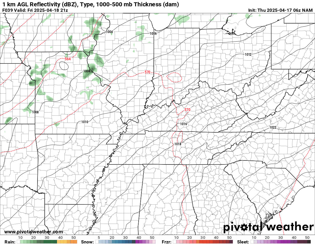
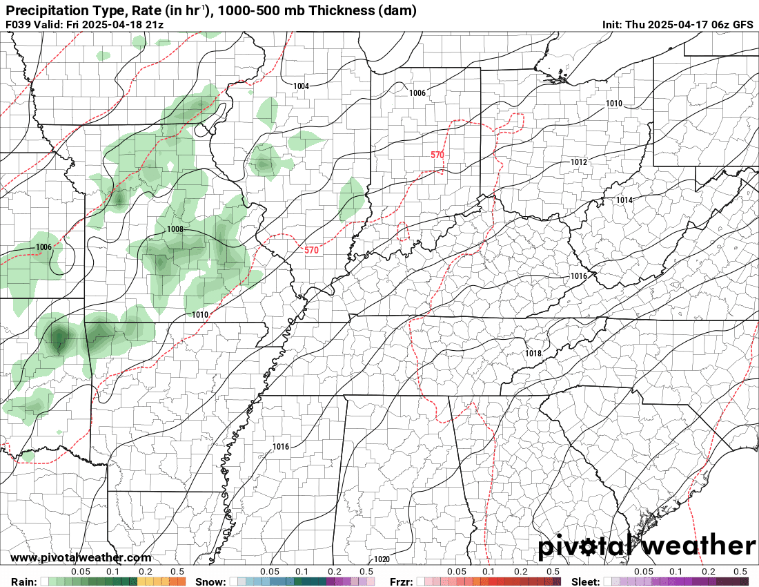
Here is the future-cast radar from the NAM model. What radar might look like from tomorrow into Sunday morning.
Notice the bulk of the rain falls across Missouri and Illinois.
The timestamp (upper left) is in Zulu. 12z=7 am. 18z=1 pm. 00z=7 pm.
Double-click the animation to enlarge it.
.
Severe Weather Outlooks
I am not overly concerned about the Friday night into Saturday night risk. I will keep an eye on it. Perhaps a few storms produce nickel-size hail and 50+ mph wind gusts. Overall, the severe weather is low.
The risk is higher on Sunday afternoon and night. This is when I am more concerned about all modes of severe weather.
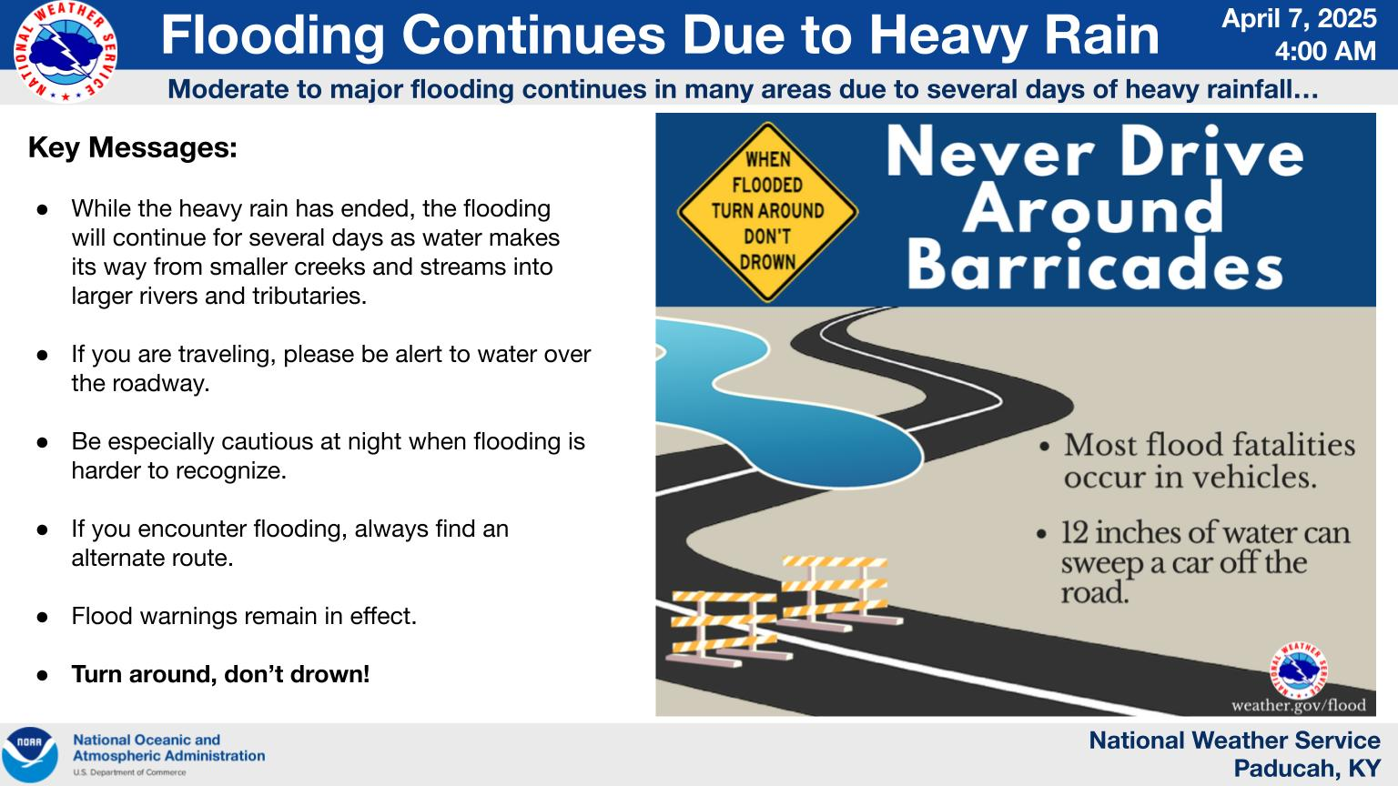
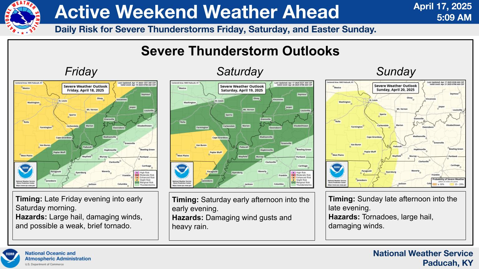
Here is what the Paducah, Kentucky, NWS posted.
Double click on the image to enlarge it.
.
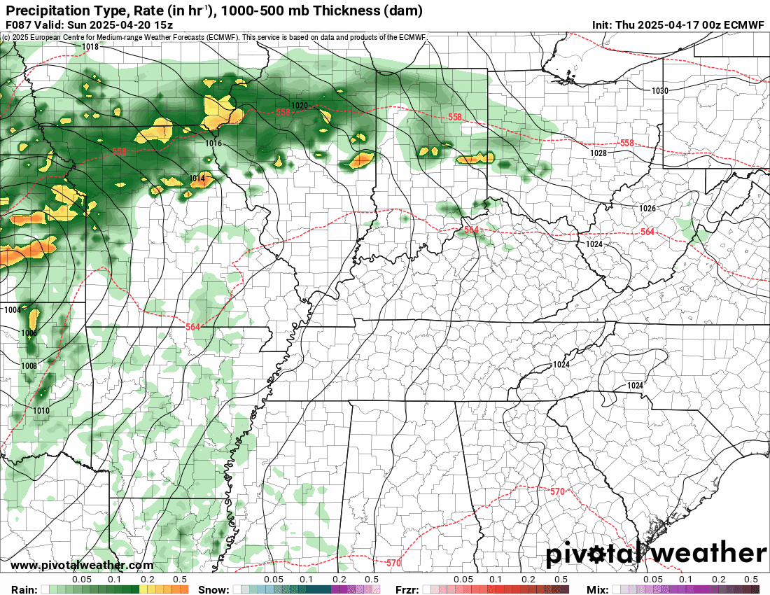
A stronger system will push into the region on Sunday. This will bring another risk of intense storms.
You can see that on the EC model. The low pressure centers pushes through Missouri to our north and west. That places us in the warm sector where storms will form.
.
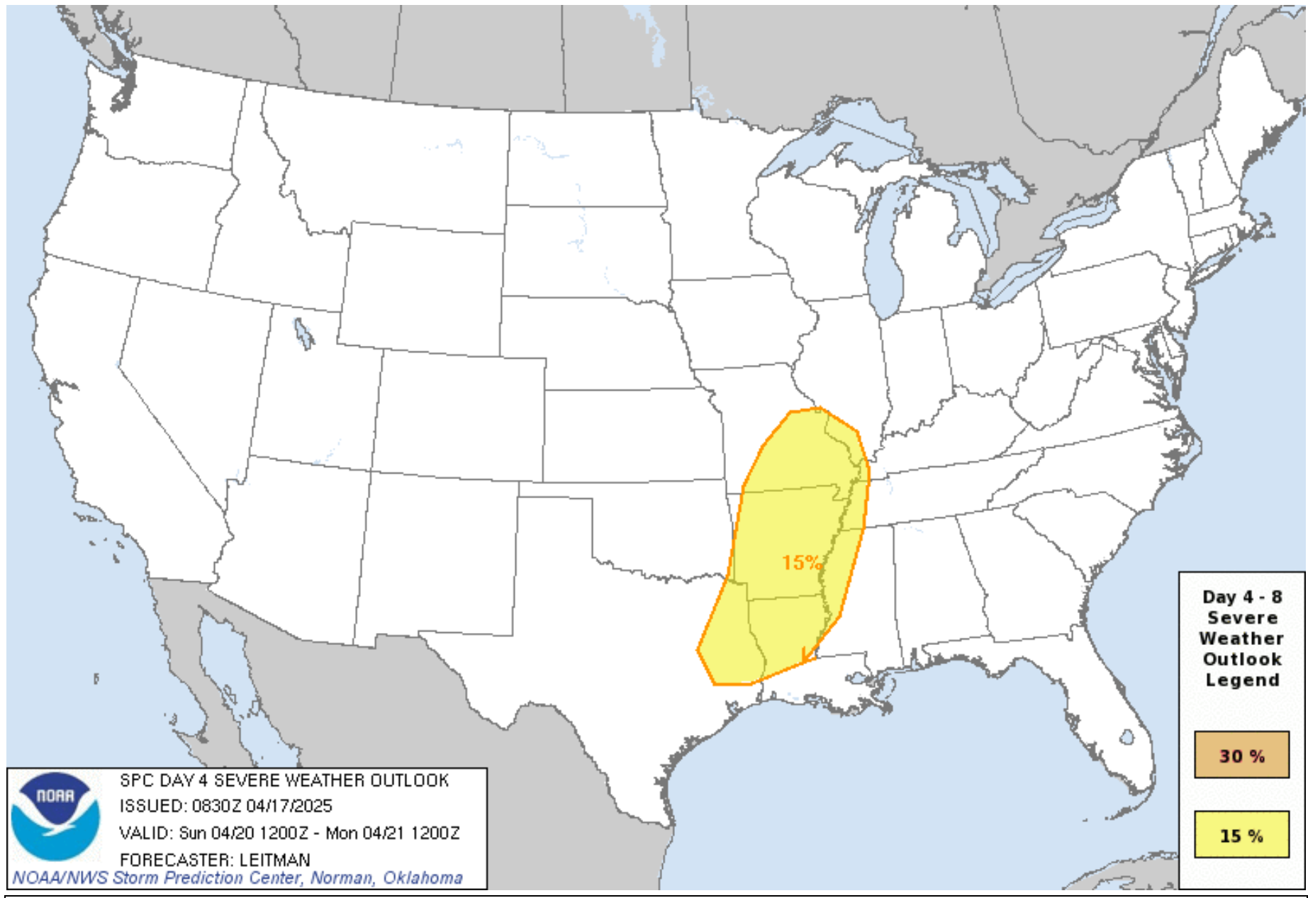
Sunday afternoon and night is the period that I am most concerned about regarding the threat of severe weather.
As you can see below, this threat covers a large portion of our region. It does leave out a portion of southern Illinois and Kentucky. I will monitor trends.
I believe, when all is said and done, we will all be under a severe risk on Sunday afternoon and night.
It would not surprise me to see this threat shift around a bit. It will depend on where the warm front is positioned.
If the system pushes a tad farther south, then more of our region would be clear of the severe threat. On the other hand, if the front stalls farther north, then more of our region would have a severe weather threat.
If you have holiday plans, then monitor my weather updates. I would not cancel plans. I would have a plan B, just in case it storms.
.
I kept a low-end chance of showers and thunderstorms on Monday, but the system may push east of our region by that time. Leaving our region dry.
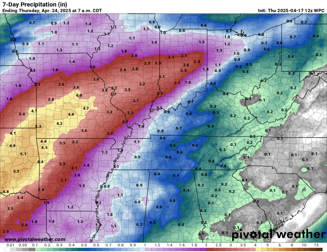
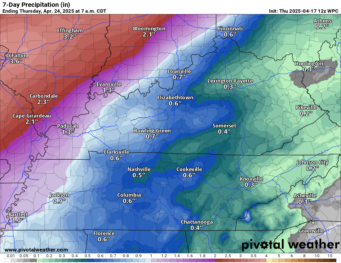
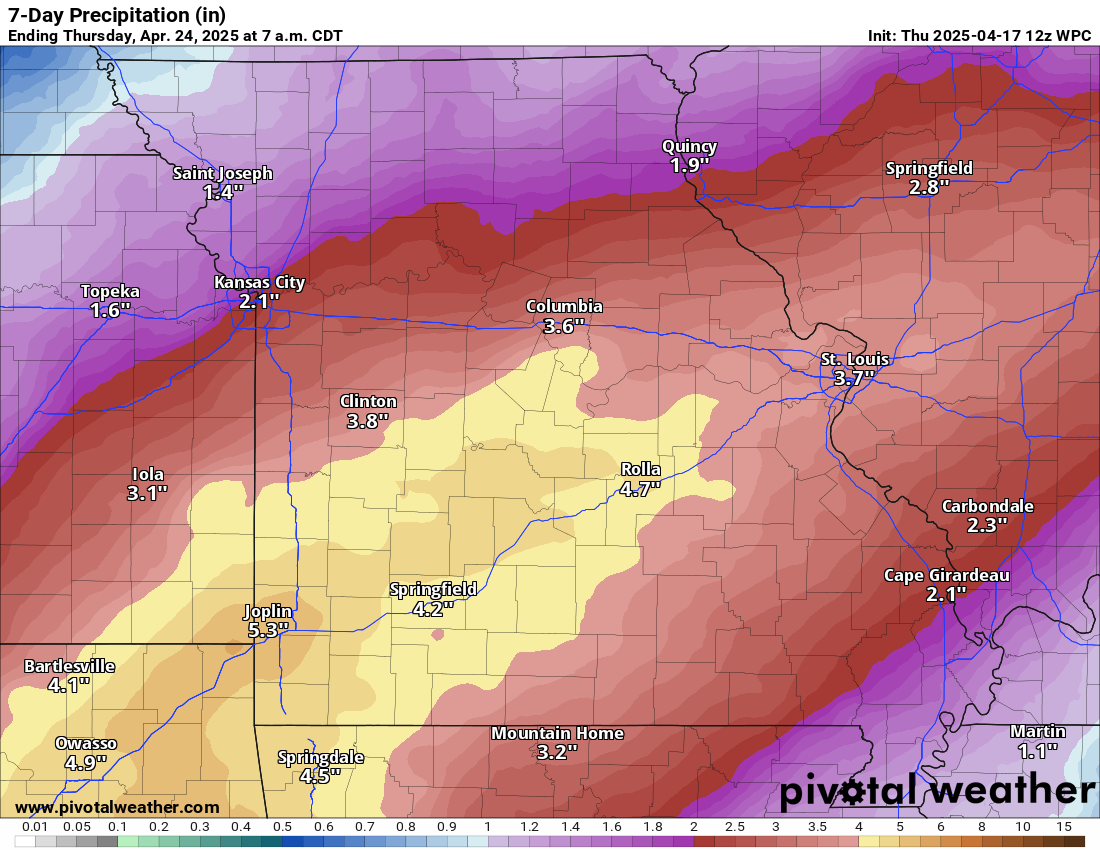
As far as rainfall totals go.
Here is the seven-day rainfall outlook. The heavier rainfall totals should be across southeast Missouri and southern Illinois.
Somewhat lower totals over Kentucky and Tennessee.
These totals should not impact the river crest levels. This could mean that rivers will remain flooded for a longer period of time.
Double click these images to enlarge them.
.

The timestamp (upper left) is in Zulu. 12z=7 am. 18z=1 pm. 00z=7 pm.
Double-click the animation to enlarge it.
GFS model
This shows you the weekend system.
.
.
.
Click here if you would like to return to the top of the page.
.Average high temperatures for this time of the year are around 68 degrees.
Average low temperatures for this time of the year are around 46 degrees.
Average precipitation during this time period ranges from 1.00″ to 1.40″
Six to Ten Day Outlook.
Blue is below average. Red is above average. The no color zone represents equal chances.
Average highs for this time of the year are in the lower 60s. Average lows for this time of the year are in the lower 40s.

Green is above average precipitation. Yellow and brown favors below average precipitation. Average precipitation for this time of the year is around one inch per week.

.

Average low temperatures for this time of the year are around 48 degrees.
Average precipitation during this time period ranges from 1.20″ to 1.50″
.
Eight to Fourteen Day Outlook.
Blue is below average. Red is above average. The no color zone represents equal chances.

Green is above average precipitation. Yellow and brown favors below average precipitation. Average precipitation for this time of the year is around one inch per week.

.
.
.
We have a new service to complement your www.weathertalk.com subscription. This does NOT replace www.weathertalk.com It is simply another tool for you to receive severe weather information.
.


.

Radars and Lightning Data
Interactive-city-view radars. Clickable watches and warnings.
https://wtalk.co/B3XHASFZ
Old legacy radar site (some of you like it better)
https://weatherobservatory.com/weather-radar.htm
If the radar is not updating then try another one. If a radar does not appear to be refreshing then hit Ctrl F5. You may also try restarting your browser.
Backup radar site in case the above one is not working.
https://weathertalk.com/morani
Regional Radar
https://imagery.weathertalk.com/prx/RadarLoop.mp4
** NEW ** Zoom radar with chaser tracking abilities!
ZoomRadar
If the radar is not working, then email me: Email me at beaudodson@usawx.com
.
We do have some sponsors! Check them out.
Roof damage from recent storms? Link – Click here
INTEGRITY ROOFING AND EXTERIORS!
⛈️ Roof or gutter damage from recent storms? Today’s weather is sponsored by Integrity Roofing. Check out their website at this link https://www.ourintegritymatters.com/

![]()
![]()
![]()
Make sure you have three to five ways of receiving your severe weather information.
Weather Talk is one of those ways! Now, I have another product for you and your family.

.
Want to add more products to your Beau Dodson Weather App?
Receive daily videos, weather blog updates on normal weather days and severe weather and winter storm days, your county by county weather forecast, and more!
Here is how to do add those additional products to your app notification settings!
Here is a video on how to update your Beau Dodson Weather payment.
The app is for subscribers. Subscribe at www.weathertalk.com/welcome then go to your app store and search for WeatherTalk
Subscribers, PLEASE USE THE APP. ATT and Verizon are not reliable during severe weather. They are delaying text messages.
The app is under WeatherTalk in the app store.

Apple users click here

Android users click here
.
Radars and Lightning Data
Interactive-city-view radars. Clickable watches and warnings.
https://wtalk.co/B3XHASFZ
Old legacy radar site (some of you like it better)
https://weatherobservatory.com/weather-radar.htm
If the radar is not updating then try another one. If a radar does not appear to be refreshing then hit Ctrl F5. You may also try restarting your browser.
Backup radar site in case the above one is not working.
https://weathertalk.com/morani
Regional Radar
https://imagery.weathertalk.com/prx/RadarLoop.mp4
** NEW ** Zoom radar with chaser tracking abilities!
ZoomRadar
Lightning Data (zoom in and out of your local area)
https://wtalk.co/WJ3SN5UZ
Not working? Email me at beaudodson@usawx.com
National map of weather watches and warnings. Click here.
Storm Prediction Center. Click here.
Weather Prediction Center. Click here.
.

Live lightning data: Click here.
Real time lightning data (another one) https://map.blitzortung.org/#5.02/37.95/-86.99
Our new Zoom radar with storm chases
.
.

Interactive GOES R satellite. Track clouds. Click here.
GOES 16 slider tool. Click here.
College of DuPage satellites. Click here
.

Here are the latest local river stage forecast numbers Click Here.
Here are the latest lake stage forecast numbers for Kentucky Lake and Lake Barkley Click Here.
.
.
Find Beau on Facebook! Click the banner.


 .
.