We have some great sponsors for the Weather Talk Blog. Please let our sponsors know that you appreciate their support for the Weather Talk Blog.
Milner and Orr Funeral Home and Cremation Services located in Paducah, Kentucky and three other western Kentucky towns – at Milner and Orr they believe in families helping families. You can find Milner and Orr on Facebook, as well.
![]()
.

For all of your families eye care needs. Visit their web-site here. Or, you can also visit their Facebook page.
.

Best at Enabling Body Shop Profitability since 1996. Located In Paducah Kentucky and Evansville Indiana; serving all customers in between. They provide Customer Service, along with all the tools necessary for body shops to remain educated and competitive. Click the logo above for their main web-site. You can find McClintock Preferred Finishes on Facebook, as well

Expressway Carwash and Express Lube are a locally owned and operated full service Carwash and Lube established in 1987. We have been proudly serving the community for 29 years now at our Park Avenue location and 20 years at our Southside location. We have been lucky enough to partner with Sidecar Deli in 2015, which allows us to provide our customers with not only quality service, but quality food as well. . If you haven’t already, be sure to make Expressway your one stop shop, with our carwash, lube and deli. For hours of operation and pricing visit www.expresswashlube.com or Expressway Carwash on Facebook.

TORNADO SHELTERS! Endrizzi’s Storm Shelters – For more information click here. Endrizzi Contracting and Landscaping can be found on Facebook, as well – click here
I have launched the new weather texting service! I could use your help. Be sure and sign up and fully support all of the weather data you see each day.
This is a monthly subscription service. Supporting this helps support everything else. The cost is $3 a month for one phone, $5 a month for three phones, and $10 a month for seven phones.
For more information visit BeauDodsonWeather.com
Or directly sign up at Weathertalk.com


This forecast update covers far southern Illinois, far southeast Missouri, and far western Kentucky. See the coverage map on the right side of the blog.
Remember that weather evolves. Check back frequently for updates, especially during active weather.

Saturday Night – Mostly clear. Cool.
Temperatures: Lows in the middle 50s
Winds: Winds East and southeast at 4-8 mph.
What is the chance for precipitation? 0%
Coverage of precipitation? None
My confidence in this part of the forecast verifying is High
Should I be concerned about snow or ice? No
Should I cancel my outdoor plans? No
Is severe weather expected? No
What impact is expected? None
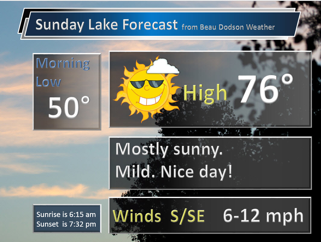
Sunday – Mostly sunny. Warmer. Spring. Well above normal temperatures.
Temperatures: High temperatures 75-80 degrees.
Winds: East and southeast winds at 5-10 mph.
What is the chance for precipitation? 0%
Coverage of precipitation? None
My confidence in this part of the forecast verifying is High
Should I be concerned about snow or ice? No
Should I cancel my outdoor plans? No
Is severe weather expected? No
What impact is expected? None.
Sunday Night – Mostly clear. Cool.
Temperatures: Lows in the lower to middle 50s
Winds: Winds east/southeast at 4-8 mph.
What is the chance for precipitation? 0%
Coverage of precipitation? None
My confidence in this part of the forecast verifying is High
Should I be concerned about snow or ice? No
Should I cancel my outdoor plans? No
Is severe weather expected? No
What impact is expected? None
Monday – Mostly sunny. Very warm. Well above normal temperatures.
Temperatures: High temperatures 75-80 degrees.
Winds: Southeast and south winds at 5-10 mph.
What is the chance for precipitation? 0%
Coverage of precipitation? None
My confidence in this part of the forecast verifying is High
Should I be concerned about snow or ice? No
Should I cancel my outdoor plans? No
Is severe weather expected? No
What impact is expected? Most likely none.
Monday Night – Partly cloudy. A slight chance for a shower or thunderstorm over southeast Missouri.
Temperatures: Lows in the middle 50s
Winds: Winds south at 4-8 mph.
What is the chance for precipitation? 20% over southeast Missouri
Coverage of precipitation? Isolated if any at all
My confidence in this part of the forecast verifying is Medium
Should I be concerned about snow or ice? No
Should I cancel my outdoor plans? No
Is severe weather expected? No
What impact is expected? Wet roads and lightning possible over southeast Missouri.
Tuesday – Partly sunny. Warm. A chance for a few scattered showers and thunderstorms. Perhaps highest chances would be over southeast Missouri.
Temperatures: High temperatures 72-76 degrees.
Winds: Southeast and south winds at 6-12 mph.
What is the chance for precipitation? 20% – 30%
Coverage of precipitation? Isolated
My confidence in this part of the forecast verifying is High
Should I be concerned about snow or ice? No
Should I cancel my outdoor plans? No
Is severe weather expected? Not at this time
What impact is expected? Maybe wet roadways. Maybe some lightning. Low confidence.
Tuesday Night – Partly cloudy. A chance for a few scattered showers and thunderstorms.
Temperatures: Lows in the upper 50s
Winds: Winds south at 6-12 mph.
What is the chance for precipitation? 30%
Coverage of precipitation? Isolated to scattered
My confidence in this part of the forecast verifying is High
Should I be concerned about snow or ice? No
Should I cancel my outdoor plans? No, but monitor radars
Is severe weather expected? Most likely no
What impact is expected? Wet roadways. Lightning possible.
Wednesday – Partly sunny. Warm. A chance for a shower or thunderstorm.
Temperatures: High temperatures 74-78 degrees.
Winds: Southeast and south winds at 10 mph.
What is the chance for precipitation? 40%-50%
Coverage of precipitation? Scattered
My confidence in this part of the forecast verifying is Medium
Should I be concerned about snow or ice? No
Should I cancel my outdoor plans? No, but monitor radars
Is severe weather expected? Most likely no, but monitor updates.
What impact is expected? Wet roadways. Maybe some lightning.
Wednesday Night – Partly cloudy. A chance for a shower or thunderstorm.
Temperatures: Lows in the upper 50s
Winds: Winds south at 10 mph.
What is the chance for precipitation? 50%-60%
Coverage of precipitation? Scattered
My confidence in this part of the forecast verifying is Medium
Should I be concerned about snow or ice? No
Should I cancel my outdoor plans? No, but monitor radars
Is severe weather expected? Most likely no
What impact is expected? Wet roadways. Lightning possible.
Thursday – Cloudy. Warm. A good chance for a shower or thunderstorm.
Temperatures: High temperatures 72-74 degrees.
Winds: Southeast and south winds at 10 mph.
What is the chance for precipitation? 50%-60%
Coverage of precipitation? Scattered to perhaps widespread
My confidence in this part of the forecast verifying is Medium
Should I be concerned about snow or ice? No
Should I cancel my outdoor plans? Have a back up plan
Is severe weather expected? Most likely no, but monitor updates.
What impact is expected? Wet roadways. Maybe some lightning.
Thursday Night – Cloudy. A good chance for showers and thunderstorms.
Temperatures: Lows in the upper 50s
Winds: Winds south at 6-12 mph.
What is the chance for precipitation? 60%
Coverage of precipitation? Scattered to perhaps widespread
My confidence in this part of the forecast verifying is Low
Should I be concerned about snow or ice? No
Should I cancel my outdoor plans? Have a back up plan
Is severe weather expected? Most likely no
What impact is expected? Wet roadways. Lightning possible.
Friday – A mix of sun and clouds. Mild. A chance for showers and thunderstorms.
Temperatures: High temperatures 70-75 degrees.
Winds: West and southwest winds at 10 mph.
What is the chance for precipitation? 50%
Coverage of precipitation? Scattered
My confidence in this part of the forecast verifying is Low
Should I be concerned about snow or ice? No
Should I cancel my outdoor plans? No
Is severe weather expected? Most likely no, but monitor updates.
What impact is expected? Wet roadways. Maybe some lightning.
Let’s monitor the last week of April and the first week of May for severe weather. Signals are there.
Expect highs on Sunday to top out in the 75-80 degree range! Average of 76 for the region. But, warmer spots likely.
The School Bus Stop Forecast is sponsored by Heath Health and Wellness. Located next to Crowell Pools in Lone Oak, Kentucky.
Visit their web-site here. And. visit Heath Health Foods on Facebook!
The School Bus Stop Forecast is sponsored by Heath Health and Wellness. Located next to Crowell Pools in Lone Oak.

Heath Health Foods is a locally owned and operated retail health and wellness store. Since opening in February 2006; the store has continued to grow as a ministry with an expanding inventory which also offers wellness appointments and services along with educational opportunities. Visit their web-site here. And. visit Heath Health Foods on Facebook!

Don’t forget to check out the Southern Illinois Weather Observatory web-site for weather maps, tower cams, scanner feeds, radars, and much more! Click here

An explanation of what is happening in the atmosphere over the coming days…
- Wow, the weather is amazing!
- Warm temperatures on in the cards through next weekend and beyond
- Rain/storm chances this week?
- Summer outlook
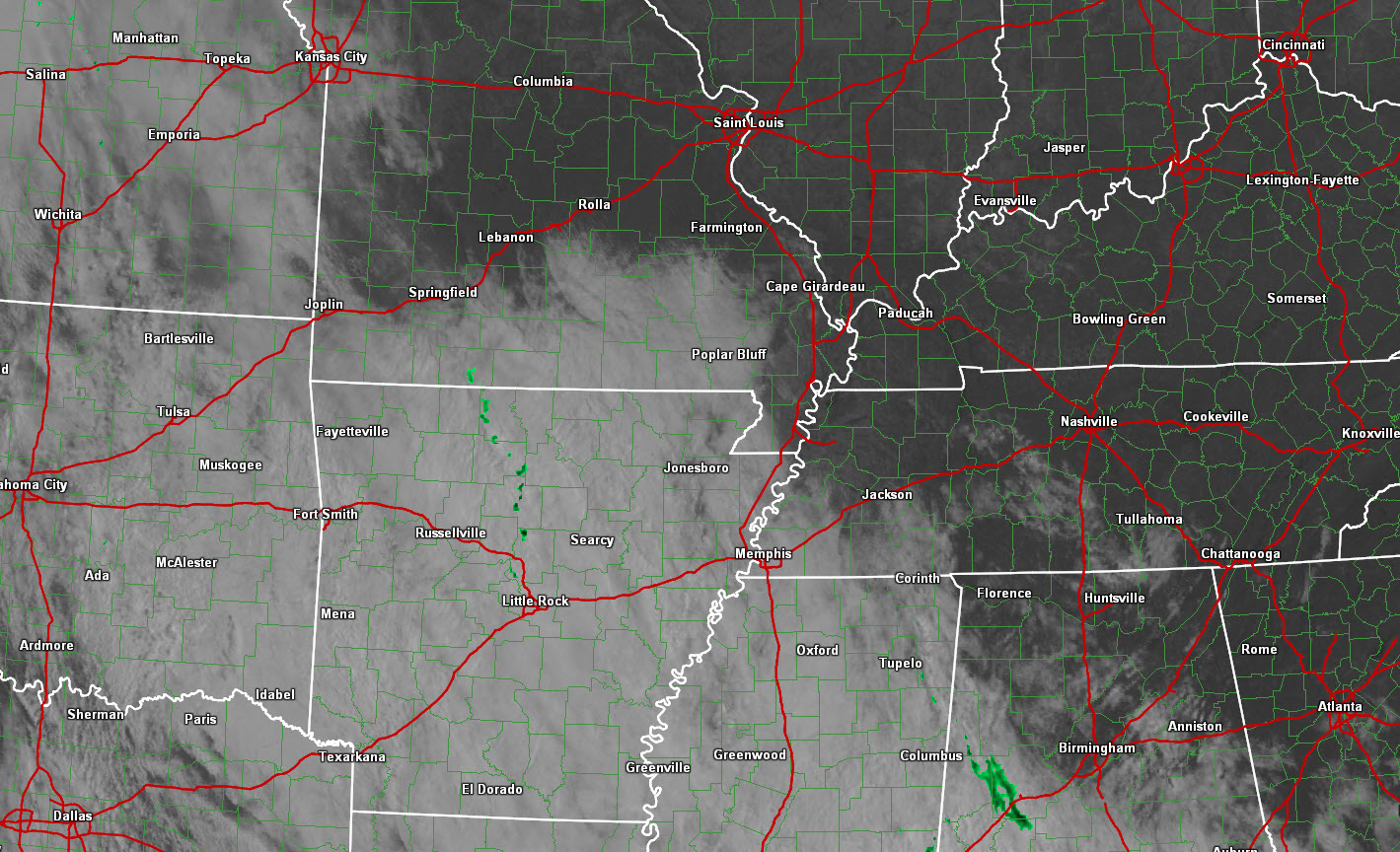
We did have stubborn clouds over southern Missouri today. But, I mentioned that was a concern. And, so it was. Here is a satellite view from Saturday morning. Those clouds just did not want to budge. Unfortunately.
Sunday:
AN AMAZING forecast. What else can I say. Expect 70s from Sunday into Friday. Plenty of sun on Sunday. It will be a wonderful day for outdoor events. Enjoy.
The week ahead:
Our next weather system attempts to approach our region on Tuesday and Tuesday night. Whether some showers or thunderstorms develop over southeast Missouri is the question. It does appear there could be a few scattered showers/storms during this time period. Perhaps higher chances over our western counties in southeast Missouri. You can see that reflected in my forecast.
Rain and thunderstorm chances will increase on Wednesday night into Thursday night. Ending by Friday morning. That is the current forecast. I am a little cautious to say that storms will end by Friday. The model guidance has an unsettled look from Friday into the following week. Several storms systems are forecast to impact our region. Each of them will deliver shower and thunderstorm chances.
I have also noted an increase in CAPE numbers from Thursday into next week. This is a concern. We may have to start thinking about severe weather over the coming weeks. For now, I am not overly concerned about this week.
The severe weather threat looks small for the upcoming week. Minimal. Perhaps not zero. Monitor updates, as always. It is spring.
Let’s look at a few charts.
These charts are from the NAM and GFS guidance (models that forecasters use for guidance). Green represents rain. Blue represents snow!
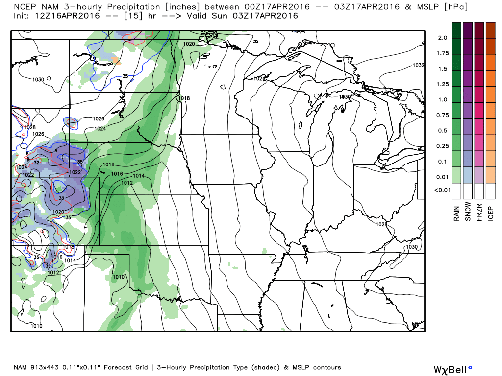
This first map is for Saturday evening. BIG snowstorm in Colorado. Several feet of snow is forecast. Imagine that.
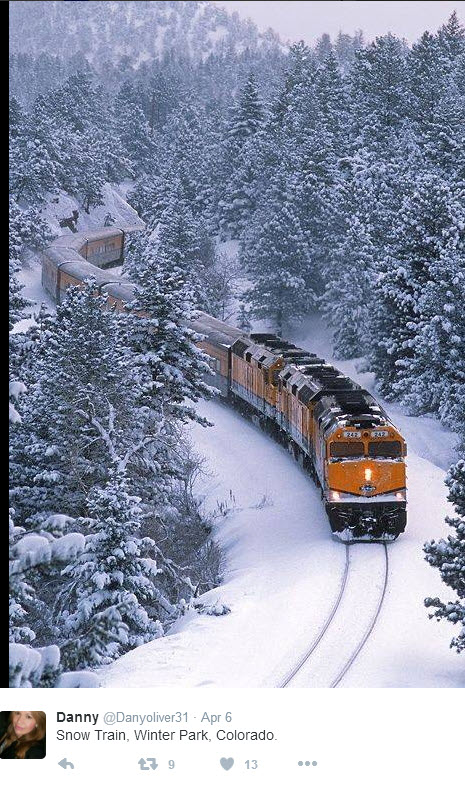
Speaking of snow. Check out this photograph from Colorado. We can at least enjoy their snow through photographs. But, we are ready for SPRING!
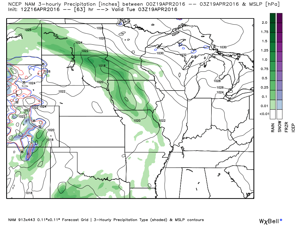
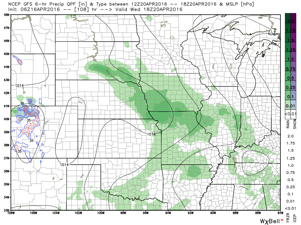
This next map is for Monday evening around 9 pm. I want you to note that guidance does show at least a chance for precipitation over parts of our region from Monday night/Tuesday onward. There is a lot of discussion about just how far east the precipitation will move on Monday night and Tuesday. Keep it in mind. I do mention shower/storm chances for Tuesday onward. Especially over the western counties in my forecast area. Mainly southeast Missouri and perhaps southwest Illinois. Better chances for rain/storms will arrive later in the week.
This next graphic is for Tuesday evening at 7 pm. The NAM actually has quite a bit of activity over the southwest part of our region. This will need to be monitored.
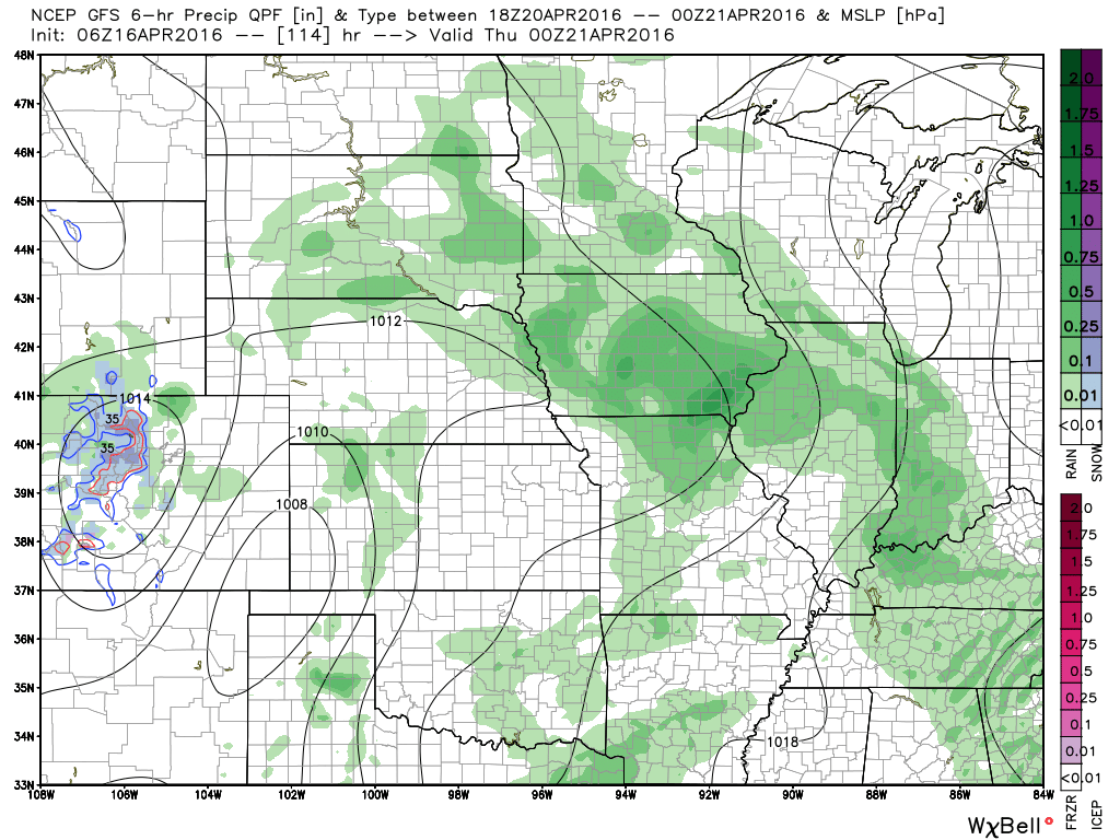
This next graphic is for Wednesday afternoon. This graphic is from the GFS. Around 1 pm on Wednesday. Again, some green in the region. Scattered showers and storms on the NAM guidance. This will need to be monitored.
I am hoping that most of the region stays dry on Tuesday into Tuesday night/Wednesday morning. But, higher probabilities for rain may have to be introduced if the system moves in faster than anticipated.
This next graphic is from the GFS guidance. This is for Wednesday around 7 pm. Again, you can see some showers and storms in the region. But, this is just one models opinion. There is guidance that suggests most of the region stays dry from Monday night into Wednesday morning/afternoon. Then increases chances for precipitation after that time frame.
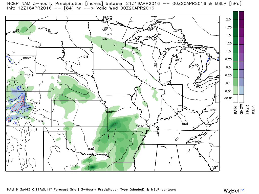
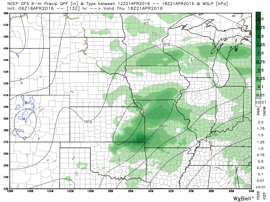
This next graphic is for Thursday afternoon. The storm system is moving east into our region. You can see the low over eastern Kansas. The closed circle. That is a closed isobar (equal lines of pressure). That is the area of low pressure pushing eastward. Thursday will be the peak of our rain chances. We will ramp up Tuesday into Wednesday night. But, Wednesday night into Thursday night is when the greatest chances for precipitation will develop. Centered on Thursday.
This next graphic is for Thursday night at 1 am. Rain in our region. Likely. Some thunderstorms, as well.
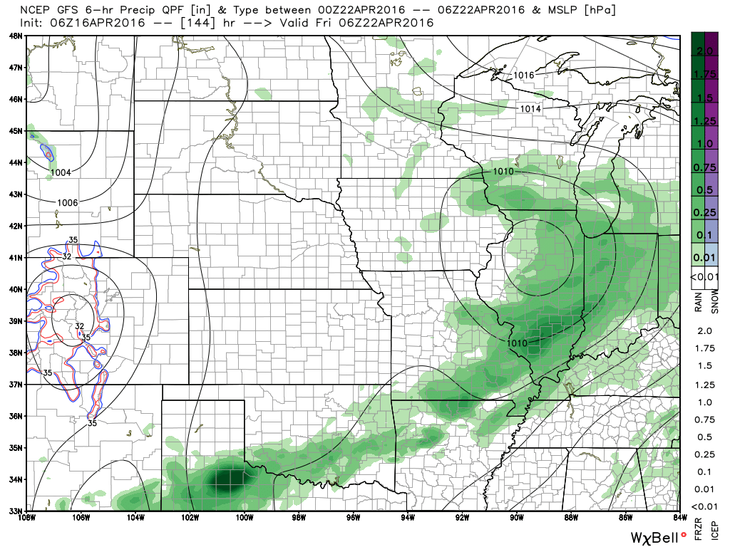
This last graphic is for Friday morning. There is some question as to just how fast the precipitation will exit our region on Friday – Sunday. Keep that in mind. Confidence is low on the forecast for Friday – Sunday of next week.

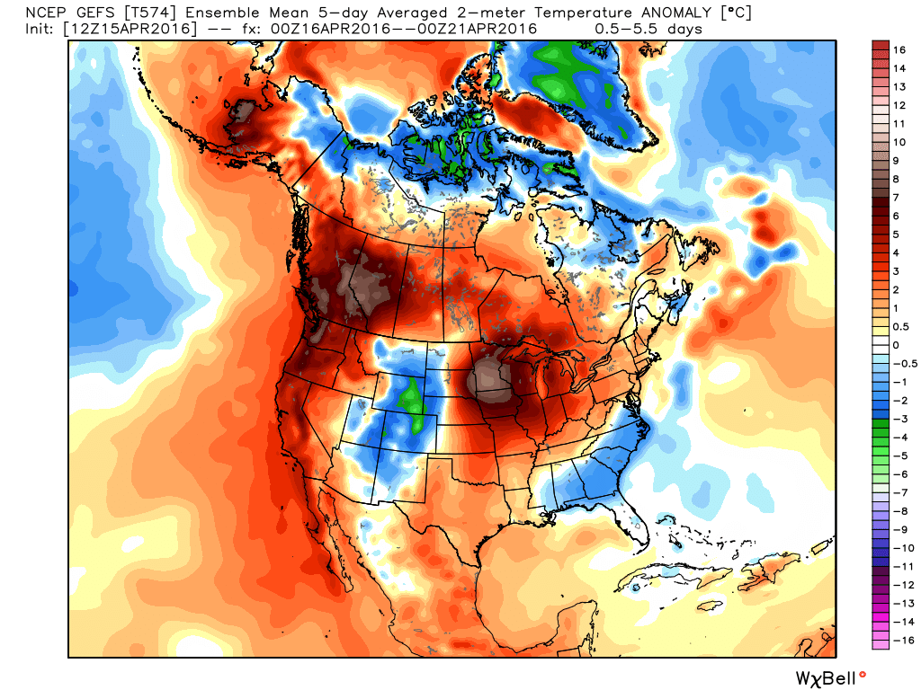
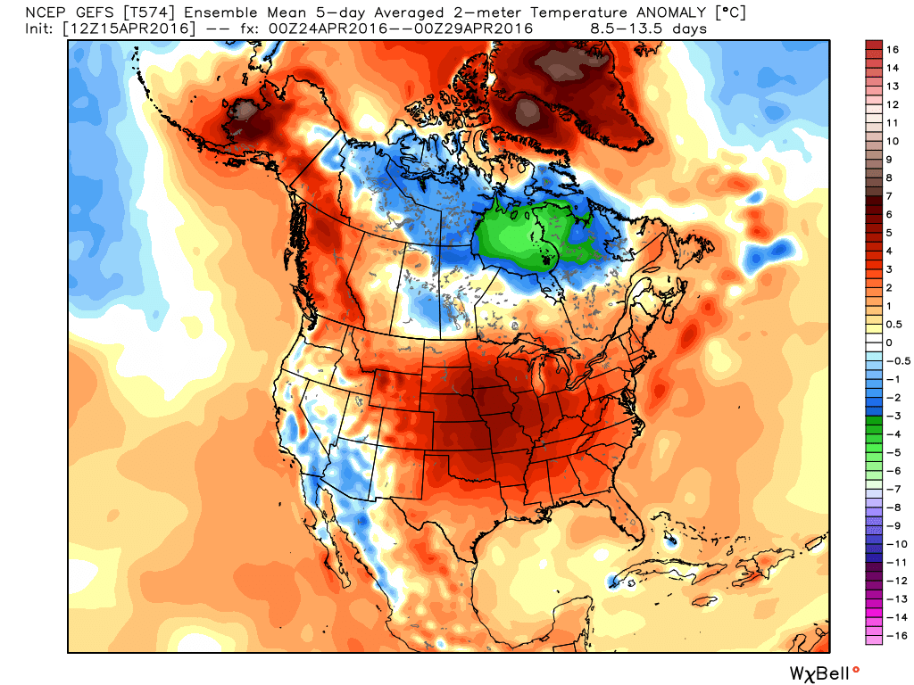
I want to show you the temperature outlook from now until May 1st. These graphics are from weatherbell.com
This first graphic is for April 16th through the 21st. Red is above normal temperatures. Dark red is WELL above normal temperatures. We will be warm.
This next graphic is for April 24th through April 29th. Warm warm and then warm! Loving this.
This next graphic is for the end of April into the first few days of May. Warm again.
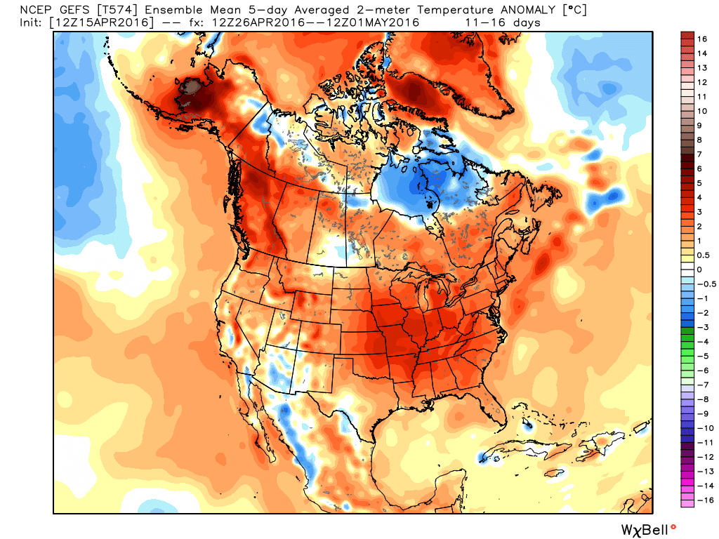
There are many signals for above normal temperatures in May. Perhaps we can finally put the cold weather behind us.
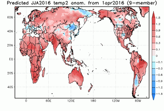
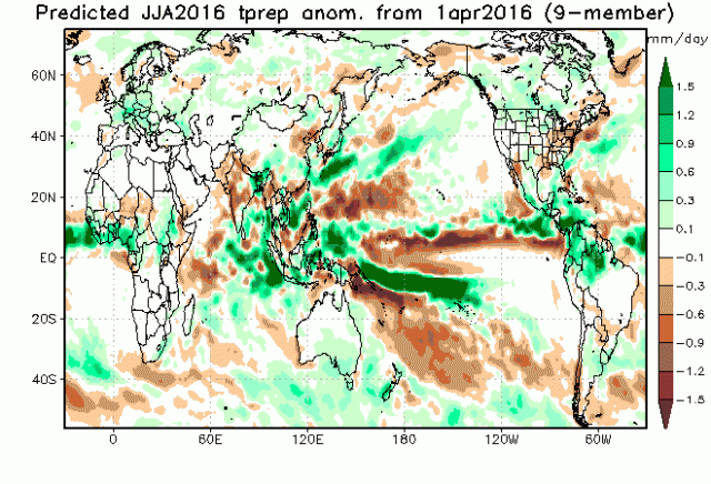
Summer forecast thoughts:
I have been looking over all the different summer forecasts. And, looking at analog years. I have talked to several other meteorologists, as well. I am leaning for a warmer than normal summer. The highest anomalies may end up over Iowa, northern Illinois, and northern Indiana (just speaking of areas near us).
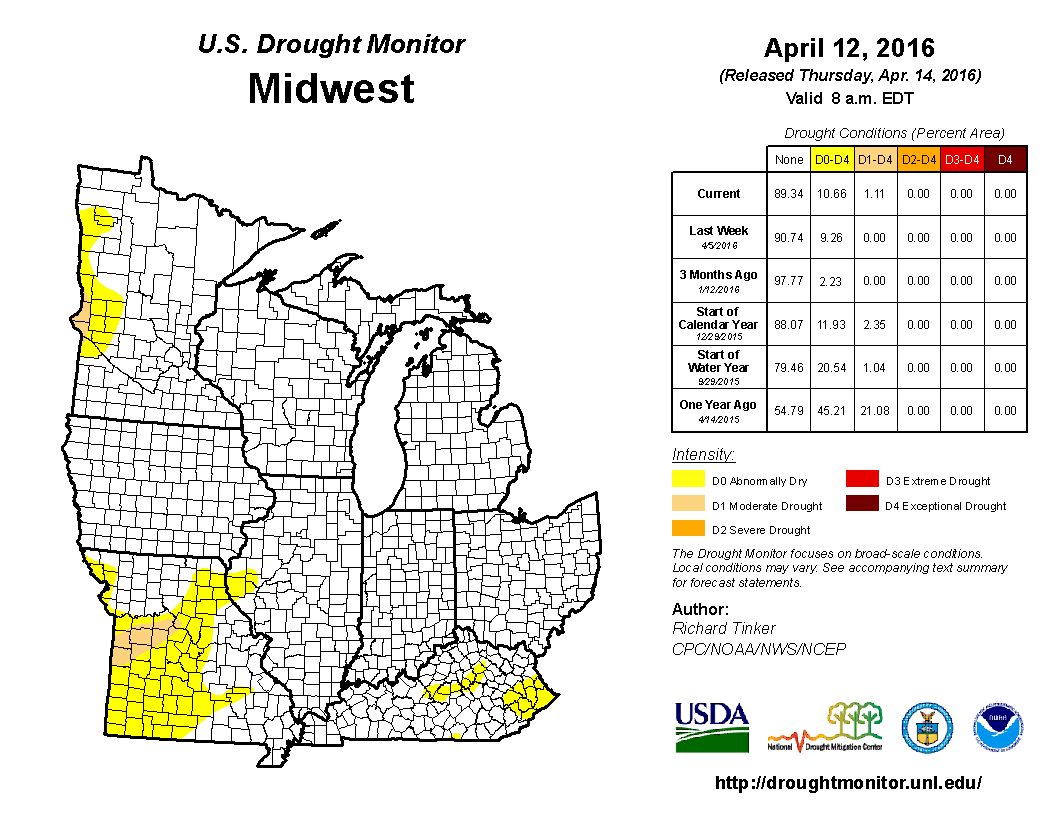
The next question becomes drought. The latest drought monitor has placed portions of Missouri in low level drought. Is this the beginning of something bigger?
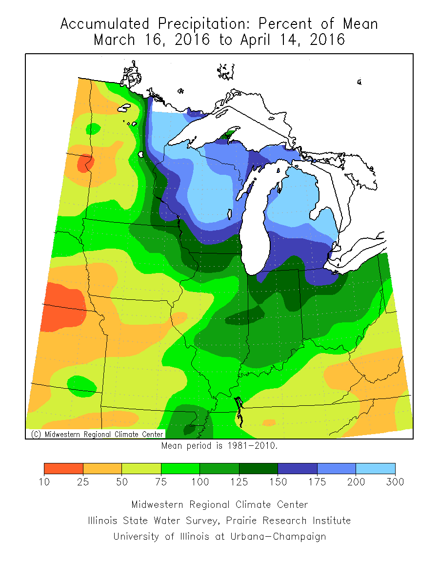
Our region has been receiving regular rainfall since December. At times, a LOT of rain. Remember, we had severe flooding in December and March. March was centered more on western Tennessee and the border counties of western Kentucky. We had the one rain event that produced 10″+ in some of our counties.
The regular rain has kept the soil moist. You do not want a dry spring. A dry spring normally leads to drought in the summer.
I am cautiously optimistic that our region, for the most part, will avoid widespread drought. I say cautiously because there are a lot of charts that point to the potential of drought in our region. Confidence in the summer forecast for temperatures is high. Expect above normal temperatures. Confidence on precipitation anomalies is low. Meaning, I am not overly confident on the rainfall part of the forecast. I feel more confident about the temperature forecast.
Perhaps our concern will be flash drought. Flash drought occurs when rain simply cuts off for several weeks. But, then returns soon after. A flash drought is just what it sounds like. A quick, but intense, dry/hot spell. You can google flash drought to read more about it. This is not a new term.
For now, let’s enjoy the next few days. Amazing weather. Highs into the 60s with lows mostly in the 48-55 degree range. Light winds, as well. Low humidity.

NOTICE on Credit Card statements for WeatherTalk. A number of cards were NOT charged in February and March. Your statement will say pending. You were never charged. Today all of the cards finally processed.
You were only charged once. Even though the “PENDING” charge would have shown up on previous statements. It was never processed.
Today it was processed.
If you signed up for monthly then it is possible you will see February, March, and April’s charges on this months statement. But, again you were never charged previously.
There was an error card in the batches and it caused all transactions on three separate days (in February and March) to be kicked out of the system. Thus, you were never charged.
I have had a couple of people ask me about this. Thinking they were charged multiple times. The only people who would see multiple charges are the ones with a monthly billing plan.
Anyone who paid up front for an entire year was only charged once. Again, you might see pending on previous statements. But, pending means you were not charged.
If you have any concerns then private message me.
Thank you and sorry for any confusion or inconvenience.
Beau

Can we expect severe thunderstorms over the next 24 to 48 hours? Remember that a severe thunderstorm is defined as a thunderstorm that produces 58 mph winds or higher, quarter size hail or larger, and/or a tornado.
.
Widespread severe weather is not anticipated through this week.
Sunday: Severe weather is not anticipated
Sunday night: Severe weather is not anticipated
Monday – Severe weather is not anticipated
Tuesday and Wednesday: Perhaps some thunderstorms. Better chances towards Wednesday night or Thursday.
Thursday – Friday: Thunderstorms are possible. Likely below severe levels.
.
.

.
Updated temperatures. Precipitation chances. Updated wind speed. No major changes.

.
FROST FORECAST:
No concerns through next weekend. Appears we may be finished with frost.
.


How much precipitation should we expect over the next few days?
.
No significant rain is anticipated through Monday night.
Next system arrives on Tuesday into Friday. Centered on Thursday. I can’t rule out some rain chances over southeast Missouri on Tuesday and Tuesday night. But, the bigger rain chances should hold off until Wednesday night, Thursday, and Thursday night.
Confidence is lower on what happens Friday and Saturday
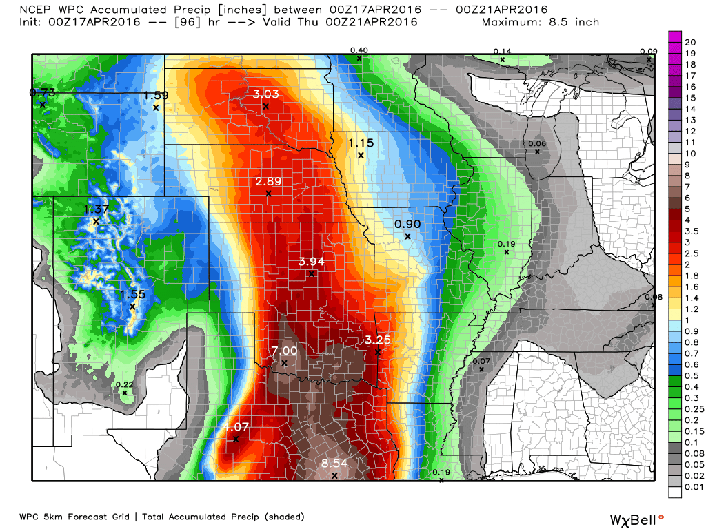
Here is the rainfall outlook for this week. Keep in mind that thunderstorms can always produce heavier totals.
This first map is through Wednesday evening. Rainfall totals. I can’t rule out some rain and storms over southeast Missouri on Tuesday and Tuesday night. Better chances arrive Wednesday night into Thursday night.
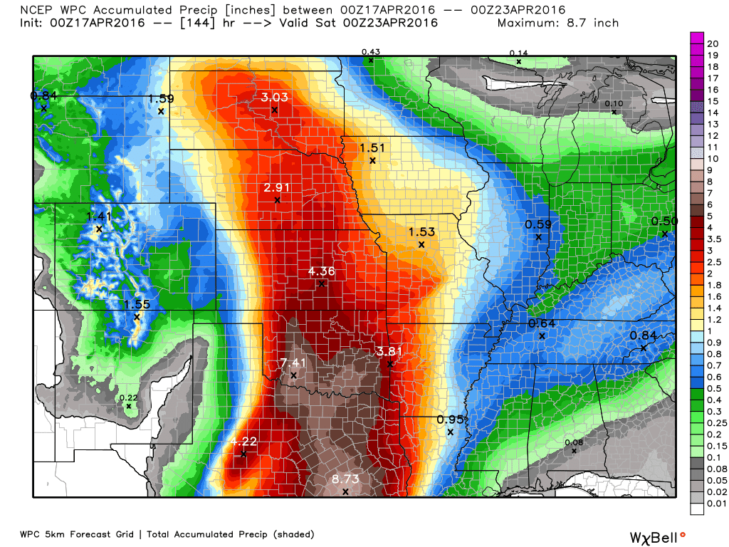
This next graphic takes us through Friday morning. You can see the rain does spread east. This is all the rain totaled from Tuesday into Friday morning. Broad brushed, as always. Locally heavier amounts can occur in thunderstorms.

Here are the current river stage forecasts. You can click your state and then the dot for your location. It will bring up the full forecast and hydrograph.
.
.

Here is the official 6-10 day and 8-14 day temperature and precipitation outlook. Check the date stamp at the top of each image (so you understand the time frame).
The forecast maps below are issued by the Weather Prediction Center (NOAA).


The latest 8-14 day temperature and precipitation outlook. Note the dates are at the top of the image. These maps DO NOT tell you how high or low temperatures or precipitation will be. They simply give you the probability as to whether temperatures or precipitation will be above or below normal.


Who do you trust for your weather information and who holds them accountable?
I have studied weather in our region since the late 1970’s. I have 37 years of experience in observing our regions weather patterns. My degree is in Broadcast Meteorology from Mississippi State University and an Associate of Science (AS). I am currently working on my Bachelor’s Degree in Geoscience.
My resume includes:
Member of the American Meteorological Society.
NOAA Weather-Ready Nation Ambassador.
Meteorologist for McCracken County Emergency Management. I served from 2005 through 2015.
I own and operate the Southern Illinois Weather Observatory.
Recipient of the Mark Trail Award, WPSD Six Who Make A Difference Award, Kentucky Colonel, and the Caesar J. Fiamma” Award from the American Red Cross.
In 2009 I was presented with the Kentucky Office of Highway Safety Award.
Recognized by the Kentucky House of Representatives for my service to the State of Kentucky leading up to several winter storms and severe weather outbreaks.
I am also President of the Shadow Angel Foundation which serves portions of western Kentucky and southern Illinois.
There is a lot of noise on the internet. A lot of weather maps are posted without explanation. Over time you should learn who to trust for your weather information.
My forecast philosophy is simple and straight forward.
- Communicate in simple terms
- To be as accurate as possible within a reasonable time frame before an event
- Interact with you on Twitter, Facebook, and the blog
- Minimize the “hype” that you might see on television or through other weather sources
- Push you towards utilizing wall-to-wall LOCAL TV coverage during severe weather events
I am a recipient of the Mark Trail Award, WPSD Six Who Make A Difference Award, Kentucky Colonel, and the Caesar J. Fiamma” Award from the American Red Cross. In 2009 I was presented with the Kentucky Office of Highway Safety Award. I was recognized by the Kentucky House of Representatives for my service to the State of Kentucky leading up to several winter storms and severe weather outbreaks.
If you click on the image below you can read the Kentucky House of Representatives Resolution.

Many of my graphics are from www.weatherbell.com – a great resource for weather data, model data, and more


You can sign up for my AWARE email by clicking here I typically send out AWARE emails before severe weather, winter storms, or other active weather situations. I do not email watches or warnings. The emails are a basic “heads up” concerning incoming weather conditions.