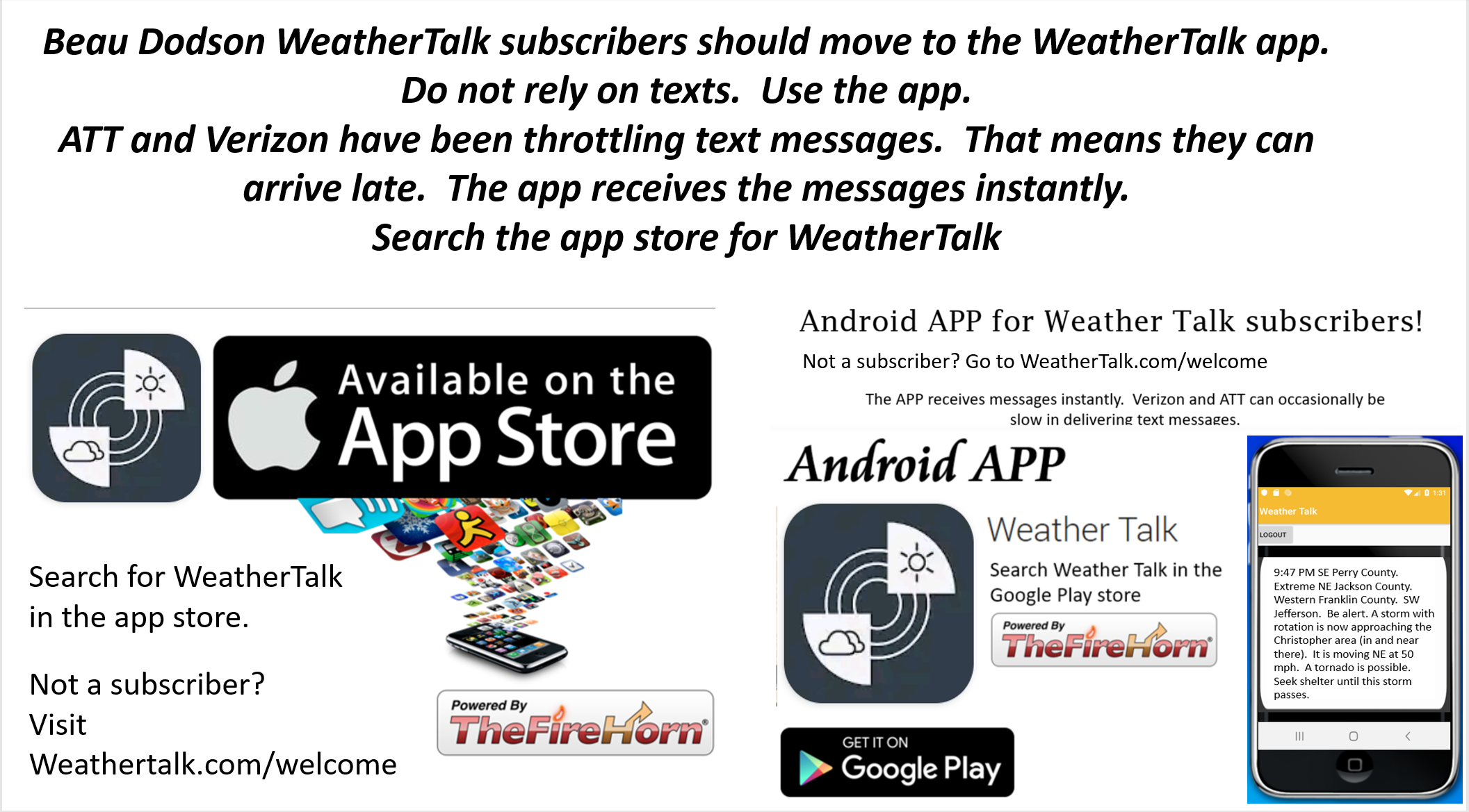
Not a subscriber? Go to www.weathertalk.com/welcome
Subscribe to Weather Talk. Then go to the app store and download it. Search for Weather Talk or Beau Dodson Weather. Apple users click here. Android users click here
.
What you need to know.
Key Points
- Thunderstorms are likely Saturday night into Sunday night.
- Severe weather is possible Sunday afternoon and night. This is a HIGHLY conditional risk. Two ingredients may be missing. If so, no severe weather will develop.
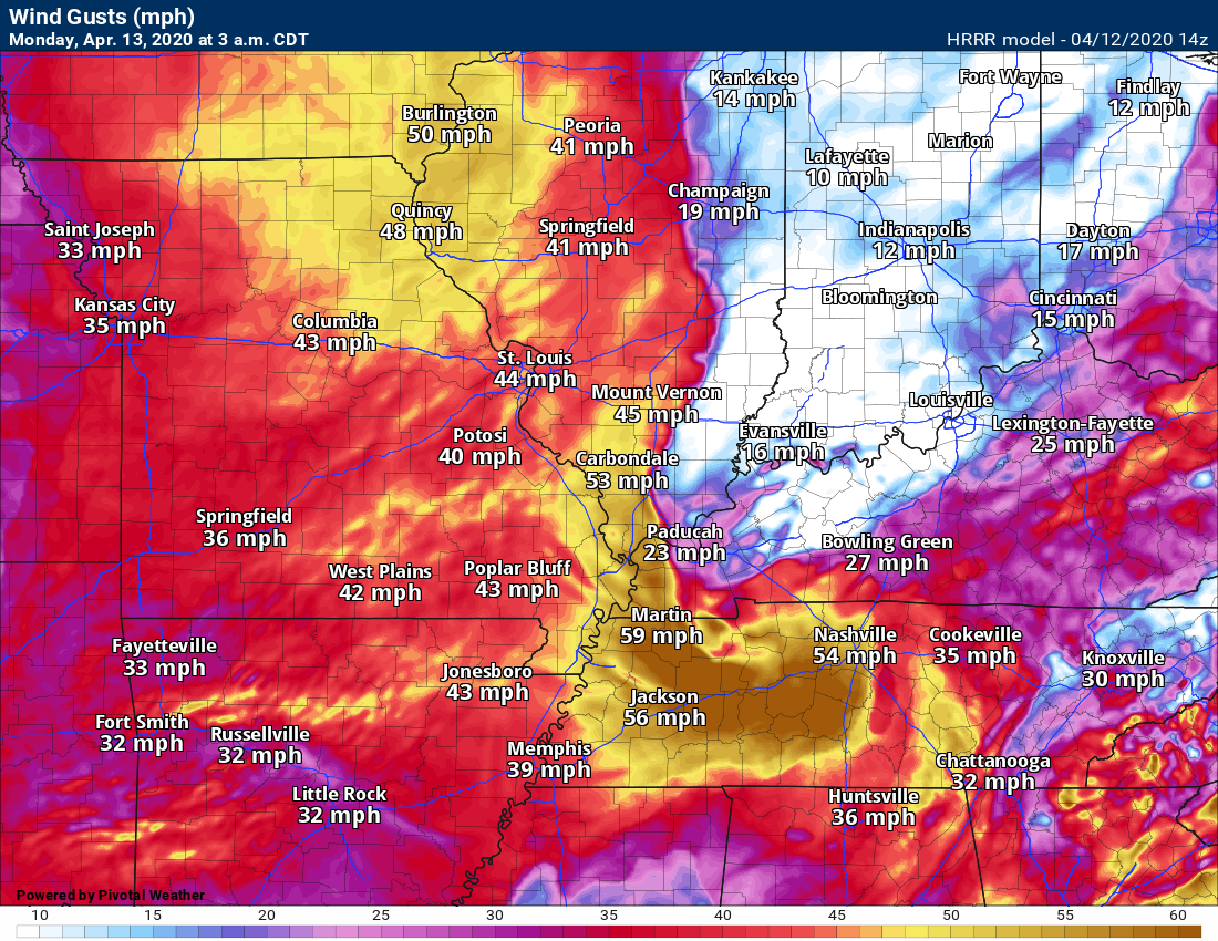
- High wind likely because of the tight pressure gradient Sunday night into Monday. Winds may top 45 mph.
- Conditional means that there remain questions about instability/CAPE (CAPE is energy for storms to tap into).
- Locally heavy rain may flood some roadways on Sunday afternoon and night.
- Have three or more ways of receiving your severe weather information. That includes my Beau Dodson Weather Talk app and a NOAA Weather Radio.
.
Call to action.
Monitor updated weather forecasts.
Make sure you are using the Weather Talk app. Download it from the app store. It is under Weather Talk.
TURN ON YOUR BEAU DODSON WEATHER TALK APP. Make sure it is on. Make sure you have not accidentally logged out of the app.
The app is for subscribers (please log into your account and make sure your payment has been updated. We have a large number of declined cards and PayPal payments.
Subscribe at www.weathertalk.com/welcome then go to your app store and search for WeatherTalk. Apple users click here. Android users click here
.
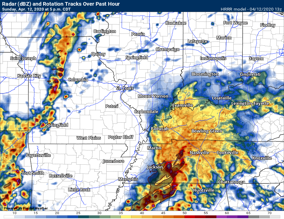
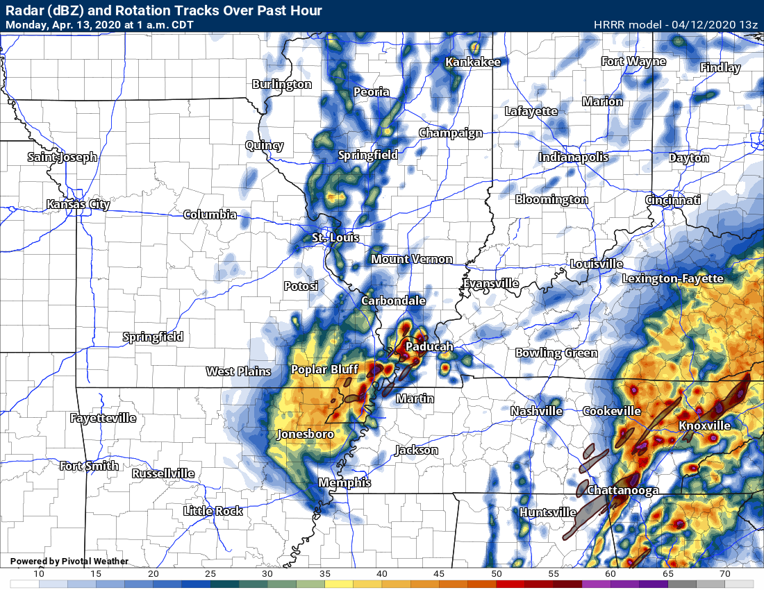
Sunday Severe Weather Outlook
1 AM
The severe weather risk has ended!
Gusty winds will be with us in to Monday. Gradient winds. Gusts above 40 mph will likely be with us into the morning hours. Non-thunderstorm winds.
Sleep well.
11:28 PM
10:45 PM
Interactive city-view radars
http://weatherobservatory.com/weather-radar.htm
Clickable watches and warnings can be viewed on the local city-view interactive radars (link above). Be sure and turn on the warnings above the local radars.
A backup radar
https://weathertalk.com/morani
A new regional radar we offer
https://imagery.weathertalk.com/prx/RadarLoop.mp4
Lightning data
http://www.lightningmaps.org/?lang=en#m=oss;t=3;s=0;o=0;b=;ts=0;z=7;y=37.3527;x=-86.7206;d=2;dl=2;dc=0;
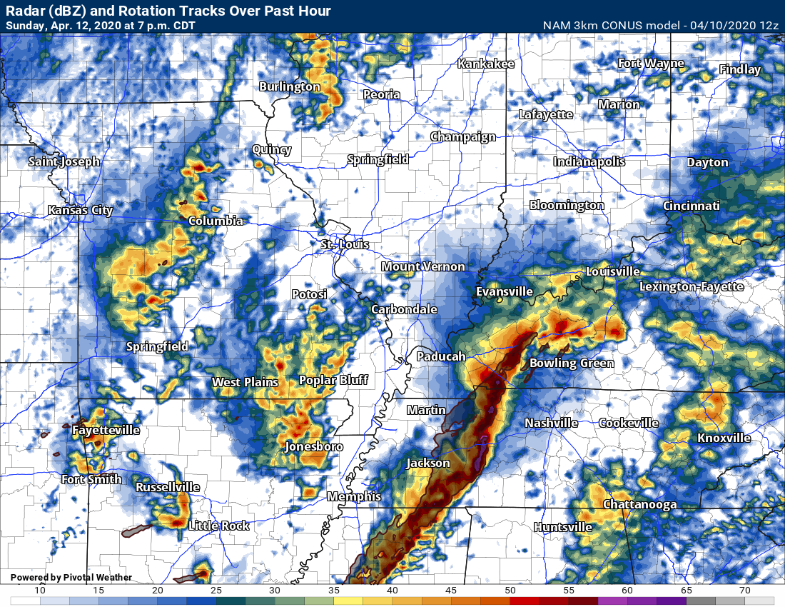
Wind gusts are the numbers.
Red boxes are severe thunderstorm warnings.
Line is moving E NE. The main concern with this line of showers and thunderstorms will be high winds.
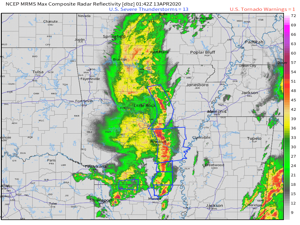
Sunday 9:30 PM
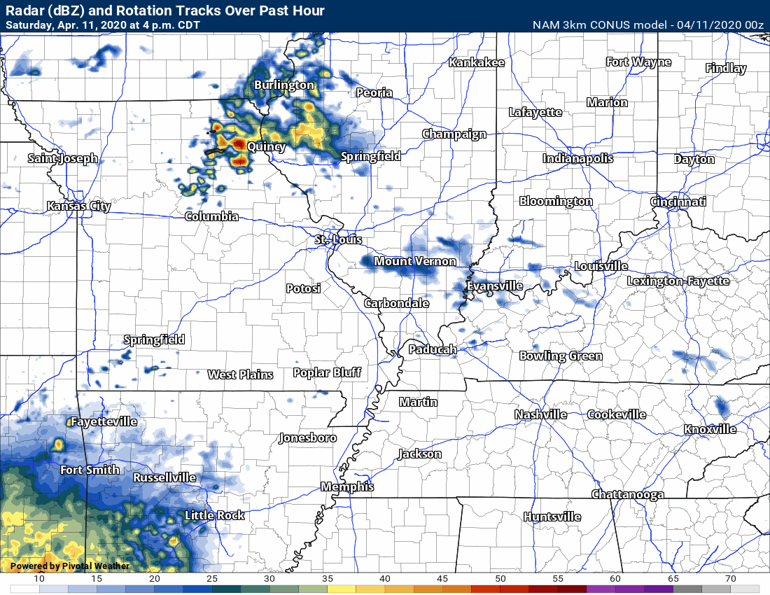
Showers and thunderstorms in Arkansas are moving east and northeast.
So far, the heaviest are staying south of the Missouri Bootheel.
I will be monitoring this area as it does move into western Tennessee and perhaps western Kentucky, as well.
The red boxes are severe thunderstorm warnings. Again, those are to our south for the time being.
Showers and thunderstorms will push back into the area overnight. A few storms could be intense with high wind.
I will continue to closely monitor the storms across the Bootheel and western Tennessee.
The atmosphere is a bit unstable over western Kentucky, as well. Not sure it is unstable enough for severe weather. Monitor updates.
Either way, strong winds will occur late tonight behind the storm system.
Interactive city-view radars
http://weatherobservatory.com/weather-radar.htm
Clickable watches and warnings can be viewed on the local city-view interactive radars (link above). Be sure and turn on the warnings above the local radars.
A backup radar
https://weathertalk.com/morani
A new regional radar we offer
https://imagery.weathertalk.com/prx/RadarLoop.mp4
Lightning data
http://www.lightningmaps.org/?lang=en#m=oss;t=3;s=0;o=0;b=;ts=0;z=7;y=37.3527;x=-86.7206;d=2;dl=2;dc=0;
.
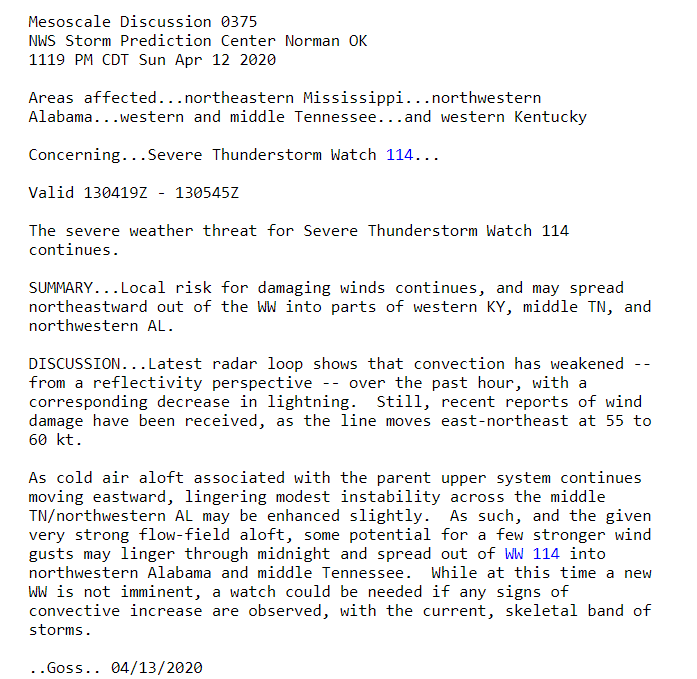
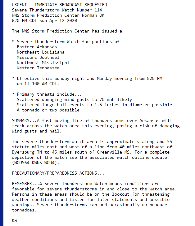
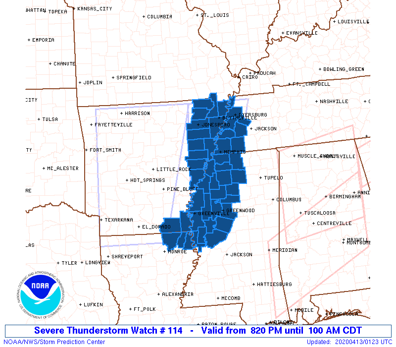
Sunday 8:25 PM
This new watch covers parts of our area. The Bootheel and portions of western Tennesse.
The rest of southeast Missouri, southern Illinois, and Kentucky is not in this watch.
I don’t believe the rest of us will be in a watch.
I will keep monitoring it.
Showers and thunderstorms will push back into the area overnight. A few storms could be intense with high wind.
I will continue to closely monitor the storms across the Bootheel and western Tennessee.
The atmosphere is a bit unstable over western Kentucky, as well. Not sure it is unstable enough for severe weather. Monitor updates.
Either way, strong winds will occur late tonight behind the storm system.
.
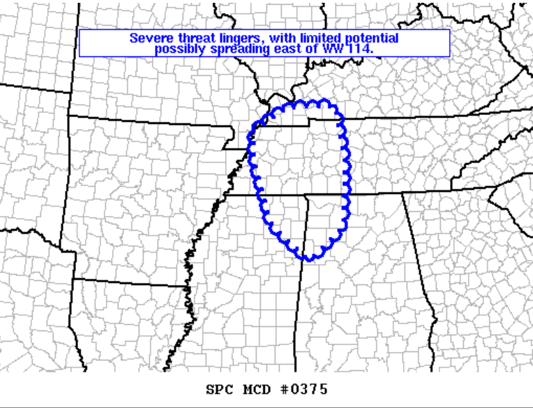
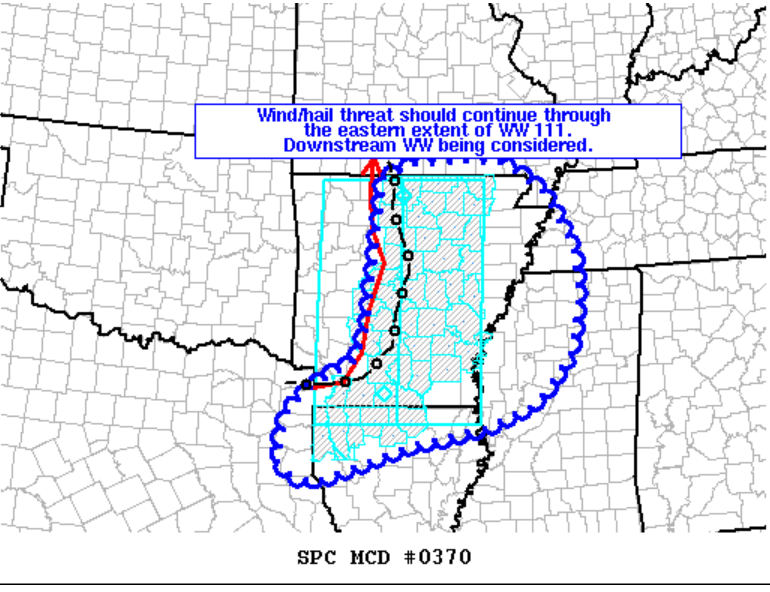
Sunday 8:20 PM
SPC may issue another watch. This new watch could include portions of our area. Most likely the Bootheel area.
.
Sunday 7:40 PM
Interactive city-view radars
http://weatherobservatory.com/weather-radar.htm
Clickable watches and warnings can be viewed on the local city-view interactive radars (link above). Be sure and turn on the warnings above the local radars.
A backup radar
https://weathertalk.com/morani
A new regional radar we offer
https://imagery.weathertalk.com/prx/RadarLoop.mp4
Lightning data
http://www.lightningmaps.org/?lang=en#m=oss;t=3;s=0;o=0;b=;ts=0;z=7;y=37.3527;x=-86.7206;d=2;dl=2;dc=0;
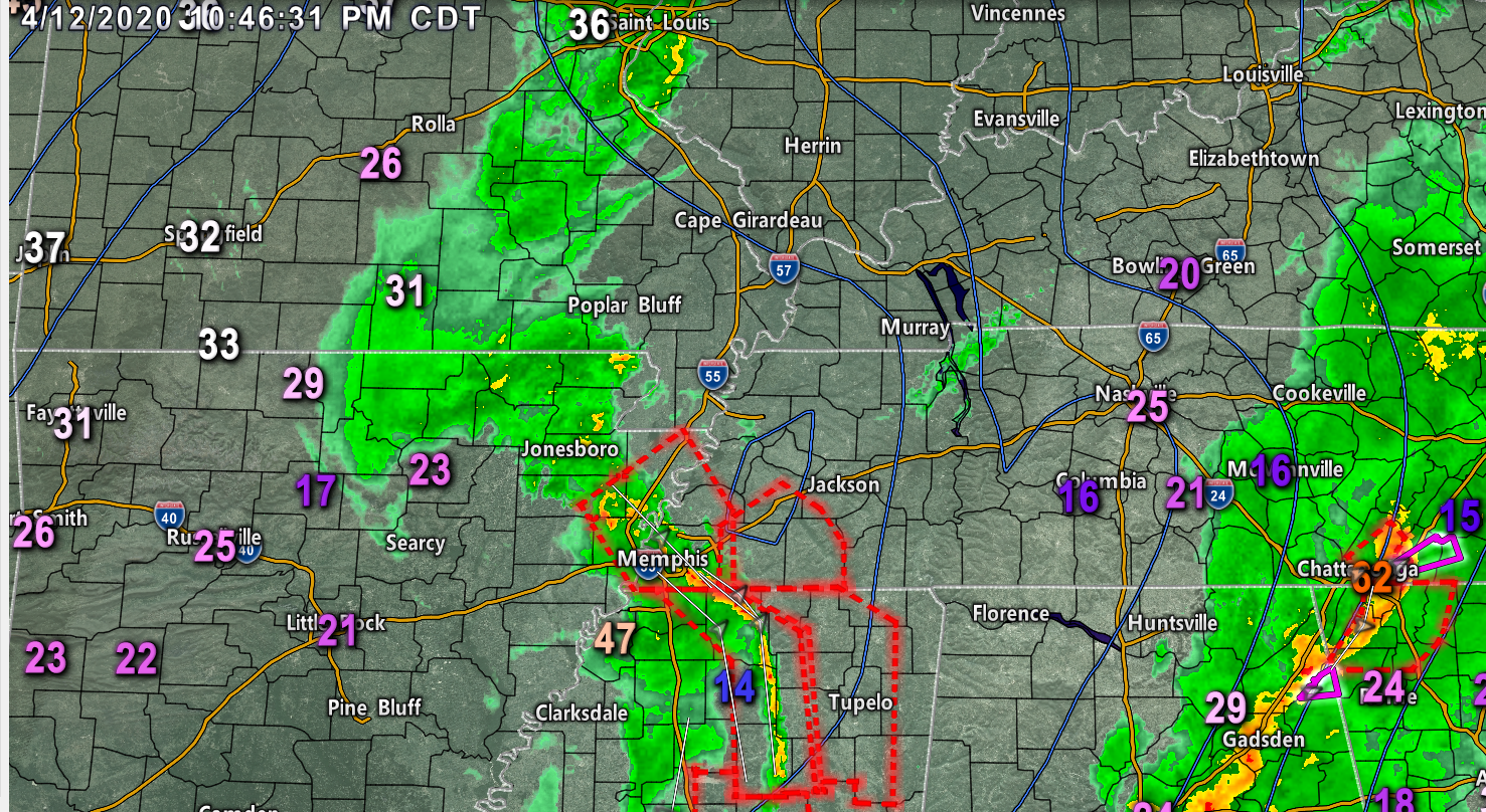
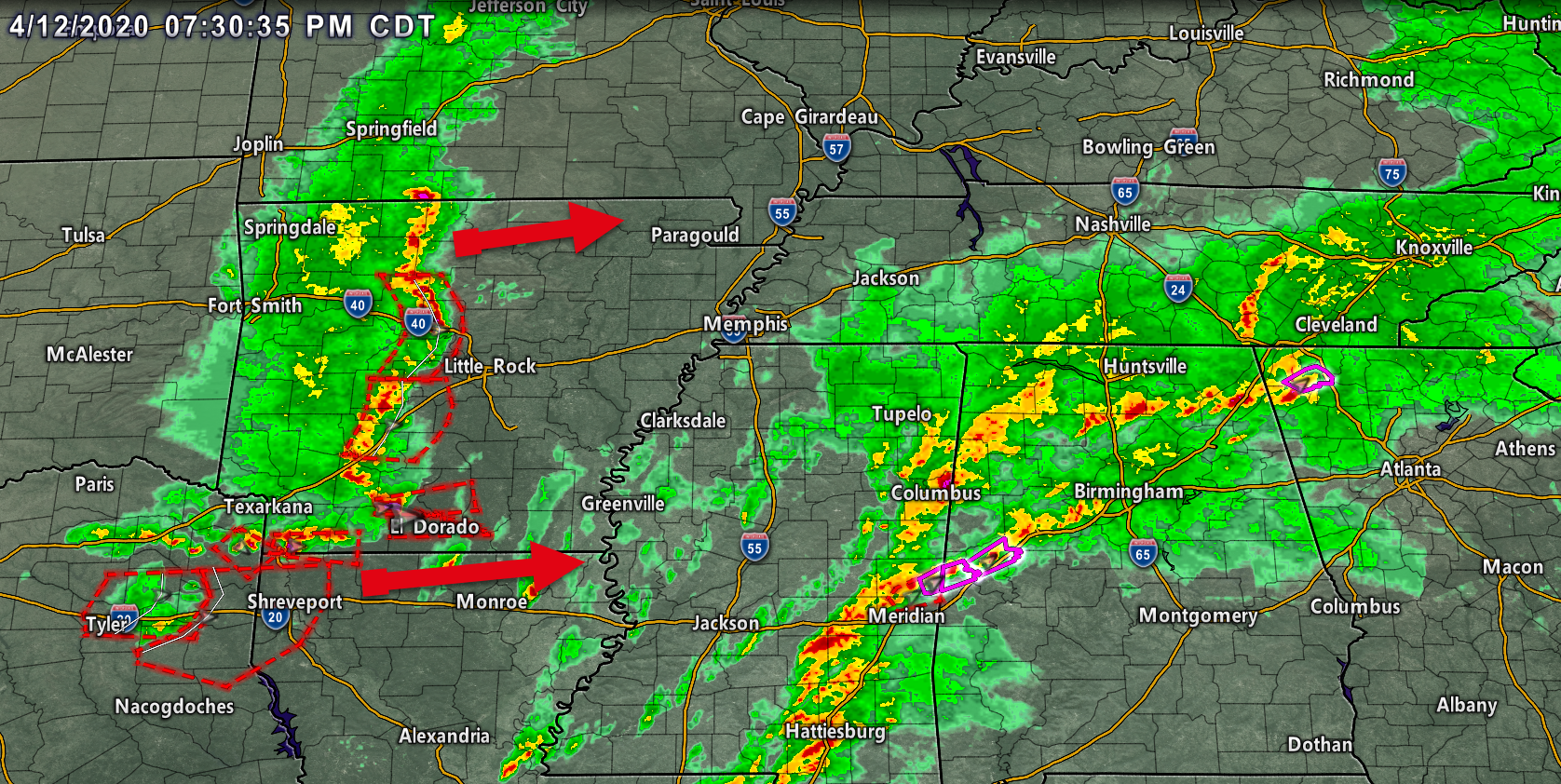
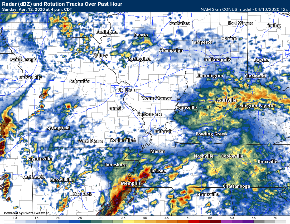
7:40 radar.
I am tracking the Arkansass storms.
Click the image to enlarge it.
.
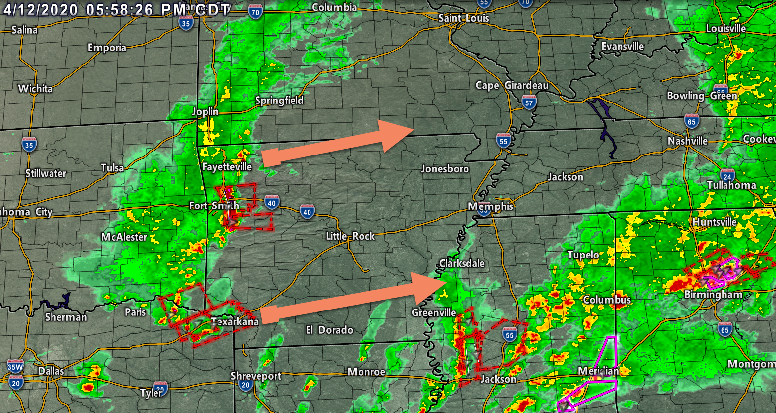
Sunday 6:15 PM
I am watching the storms in Arkansas. They will move E NE over the coming hours.
Those will eventually move into the Missouri Bootheel and western Tennessee. Parts of Kentucky.
There remain questions about their intensity once they move into our region. They should weaken with time.
Click the image to enlarge it.
.
Sunday 3:30 PM
Paducah, Kentucky, National Weather Service statement.
I agree with this. Our forecast is the same.
The main issue continues to be with instability. Taking a look at
the 12Z GFS, 18Z RAP, and various CAM models, a narrow corridor of
up to 500 J/kg MLCAPE is forecast to gradually erode as it shifts
east across southern Missouri this evening. However, an increase
in MLCAPE is possible by late evening and around midnight over the
southeast Missouri bootheel and western Kentucky in response to
the approaching shortwave trough and surface low. Any storms that
develop in this environment will be capable of producing pockets
of damaging winds, and a brief mesovortex tornado or two cannot
be completely ruled out. The main time frame for this potential
appears to run from about 9 PM until 3 AM or so.
The precipitation will rapidly diminish from west to east late
tonight as the low rapidly departs to the northeast. On the back
side of the low, a period of very strong gradient winds will
unfold. At their peak, sustained winds of 25 to 35 mph with gusts
as high as 40 to 50 mph are possible. There are some indications
that winds could gust even higher, which would close in on High
Wind Warning criteria. For now, will keep the Wind Advisory going
and adjust the forecast as needed through the night.
.
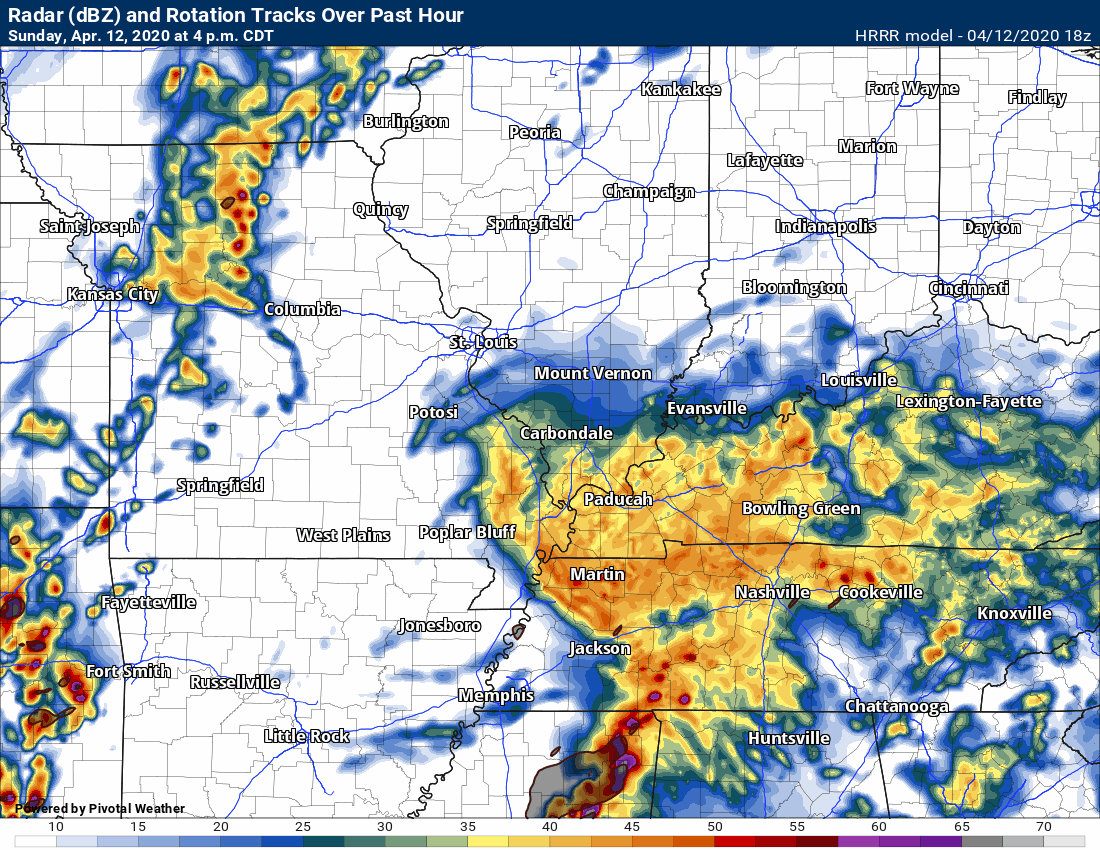
Sunday 3 PM
Widespread rain is keeping the atmosphere stable. This is good news.
I will need to monitor storms coming out of MO and AR later tonight, as well.
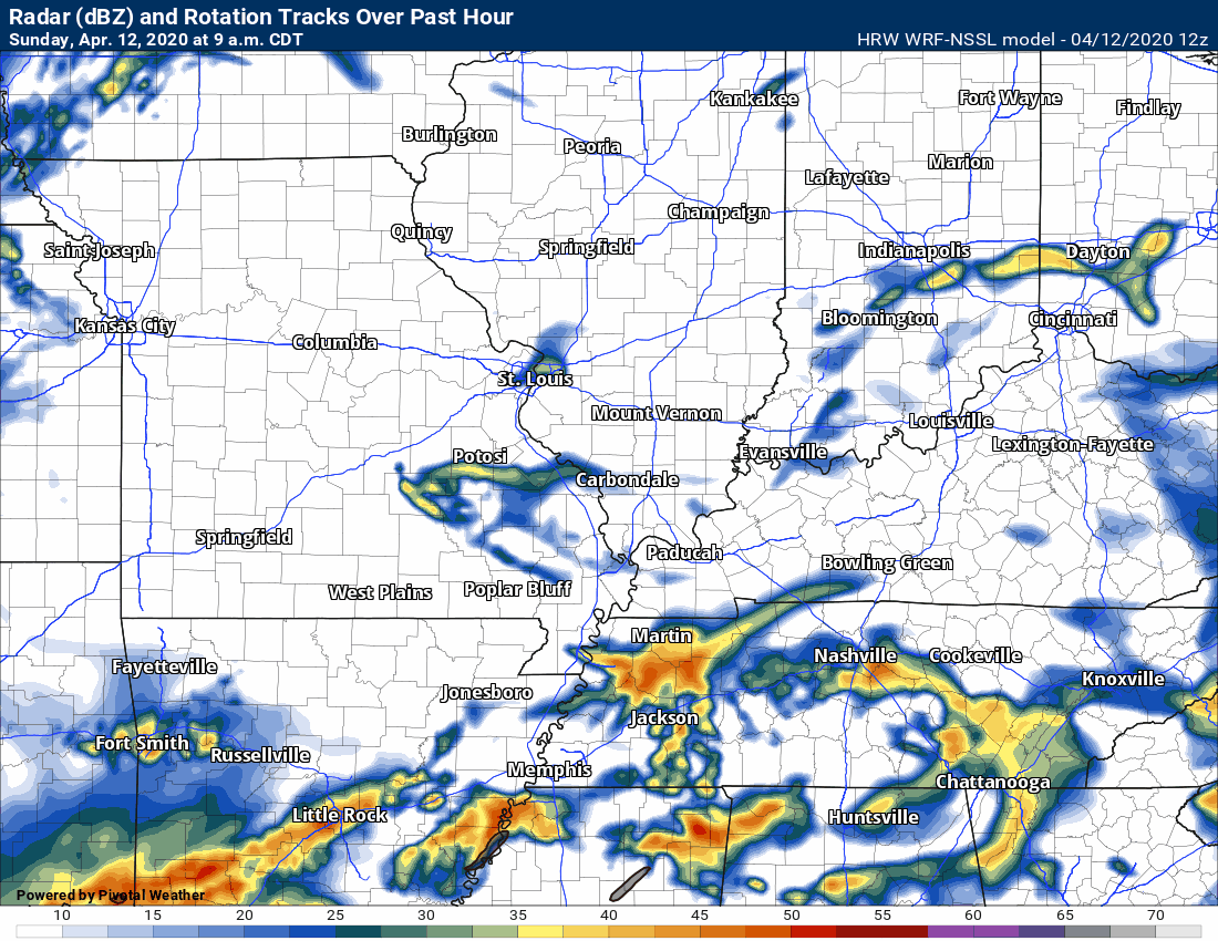
Here is the latest Hrrr model guidance.
The QLCS system should remain to our south and east. That is good news.
I will be monitoring thunderstorms tonight. Those storms would likely move in from Arkansas and Missouri. For now, the severe risk appears low. It will need to be monitored.
QLCS is a line of thunderstorms. Notice it passing through Tennessee and Mississippi. That is the severe line.
Then, later tonight, another area of showers and perhaps a thunderstorm advances across the area.
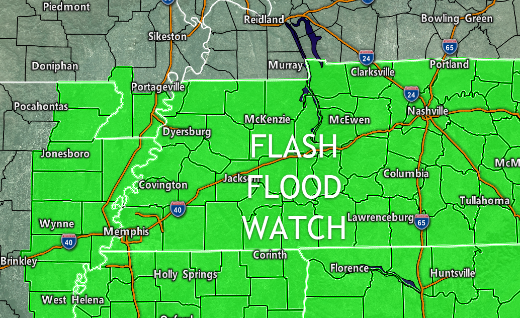
Sunday 12:20 PM
A flash flood watch has been issued. This will last well into tonight.
Avoid flooded roadways. Green zone.
Areas to the north should monitor rainfall totals, as well. There could be some issues (esp in Kentucky).
Sunday 11 AM Update
Bottom line:
We need to closely monitor this afternoon into tonight. Models have shifted southward with the area of low-pressure, we still are not completely out of the woods when it comes to the potential of a few severe thunderstorms.
The risk appears to be lower than it was 24-hours ago. Either way, we need to monitor the situation.
** High non-thunderstorm winds likely tonight into Monday morning **
Highest wind gusts may not arrive until after midnight.
I continue to monitor a lower-end risk of severe thunderstorms. Mainly across the Bootheel into parts of western Tennessee and Kentucky. Areas to the north and west should monitor (the risk is lower there).
Here are my latest forecast thoughts.
Guidance has shifted slightly southward with the center of low-pressure. The further south the low tracks, the lower our severe weather risk.
.
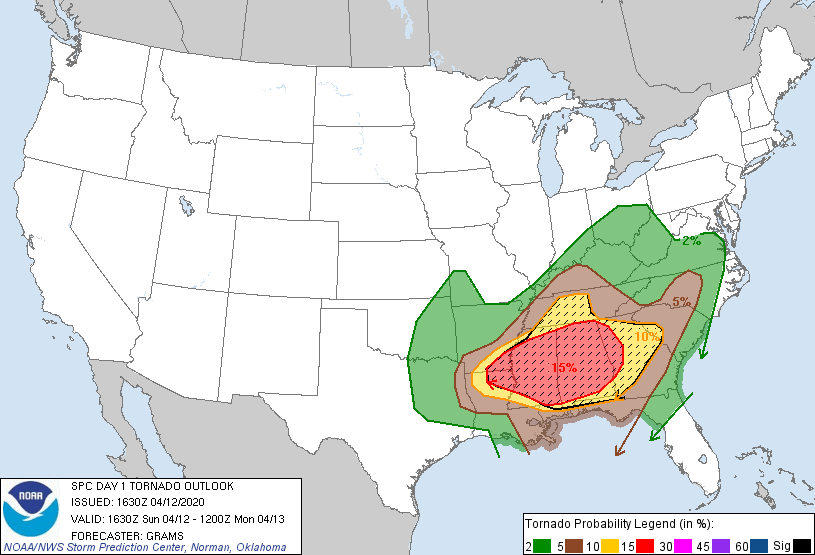
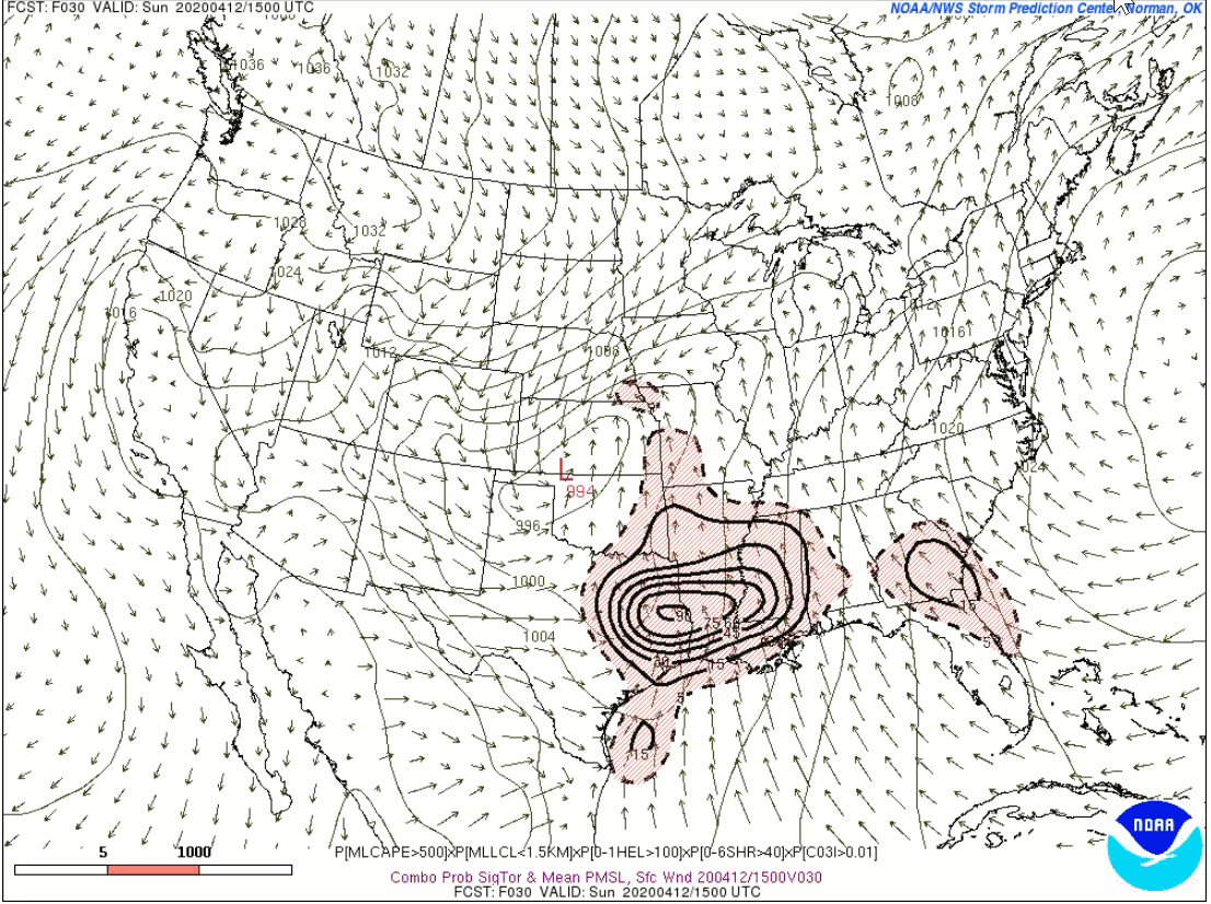
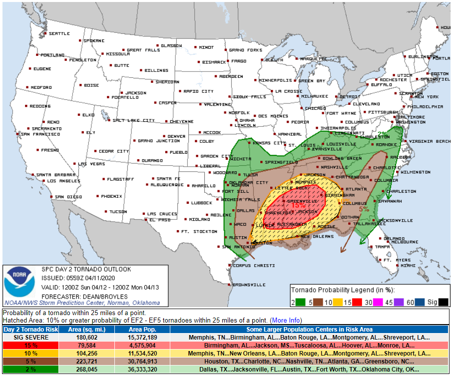
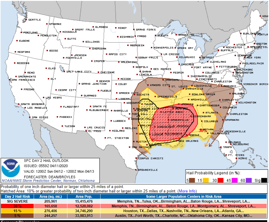
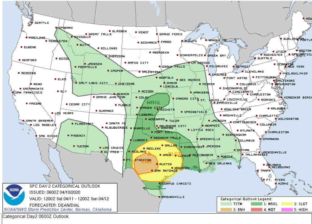
Let me show you what the Storm Prediction Center is forecasting.
No change to the forecast thinking that the risk is much higher to our south. From Louisiana into Mississippi/Alabama/Georgia.
Click on the images to enlarge them.
Tornado threat zone.
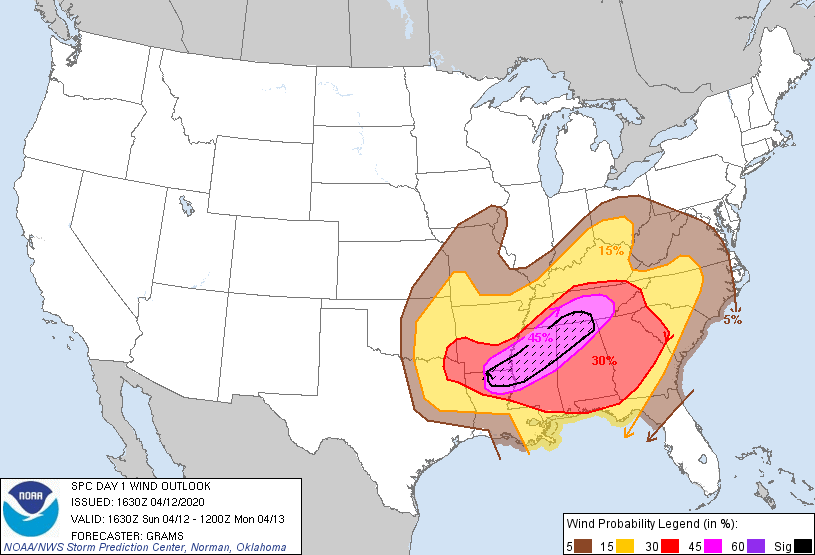
Damaging wind threat zone.
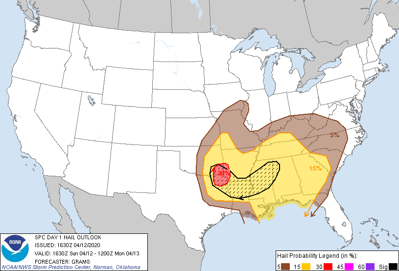
Hail threat zone.
.
.
First, let me remind everyone that strong winds are likely tonight into Monday behind our departing storm system. Winds will likely top 45 mph. These will be non-thunderstorm gradient winds. Keep in mind there could be showers and thunderstorms in the area as well.
Gradients winds are produced by rapidly falling or rising air pressure. These are considered non-thunderstorm winds. It will be a windy night in the region. That wind will linger into Monday.
It may wake you up tonight. Secure any loose objects that might blow over. Flower pots/other.
The Hrrr high-resolution model shows a possible wake low. A wake low occurs when barometric pressure (some of you have barometers on your wall) rapidly rises. This can occur behind an area of thunderstorms. It can occur behind a low-pressure center.
The Hrrr model is showing this.
Those winds would move northeast. Hopefully, the Hrrr is overdoing it, a bit. We had a similar event back in January. It produced wind gusts above 70 mph across Tennessee and into portions of Kentucky. There was quite a bit of damage.
I have winds gusting above 45 mph in my forecast. This will need to be monitored. Either way, plan on strong and gusty winds tonight into Monday morning.
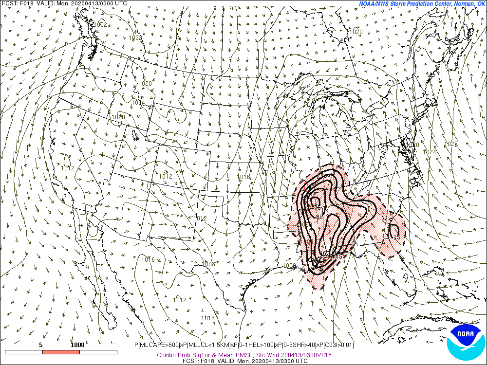
Severe Weather Outlook
A highly conditional risk of severe weather will continue this afternoon and tonight. Nothing has changed about that portion of the forecast.
What does highly conditional mean? It means that there are ingredients missing for severe weather. If they do not materialize then the risk of severe storms is much lower.
This has been the same forecast for the past three days. A conditional severe weather risk.
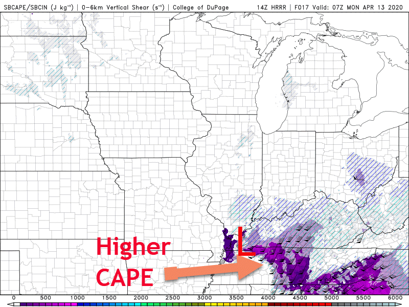
There remain two missing ingredients in this event. Higher dew points and CAPE. CAPE is energy for storms to tap into. Without CAPE, you won’t have severe weather.
CAPE is typically higher south and east of the center of low-pressure.
.
Higher dew points will pool south of the warm front. The further south the warm front is placed, the lower our severe weather risk. It will be close.
.
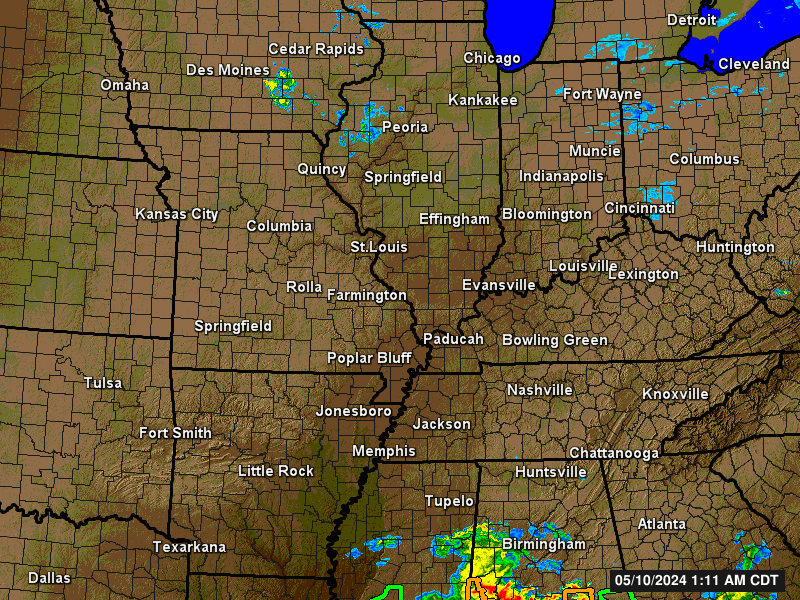
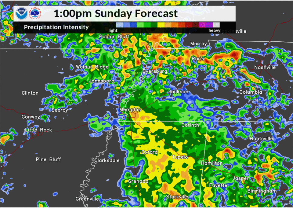
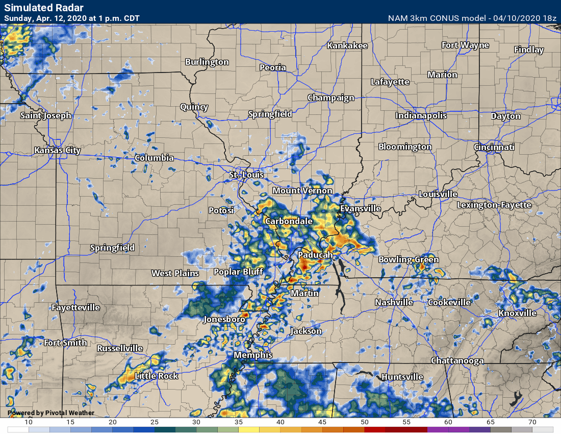
At this hour, a large area of showers and severe thunderstorms covers portions of Texas, Louisiana, Arkansas, Mississippi, and Tennessee.
LIVE radar. CLICK HERE TO VIEW
This is helping to slow the moisture moving northward. Remember, I discussed this possibility yesterday.
This is good news, as well. The longer the moisture is blocked to our south the lower the chance of severe weather locally.
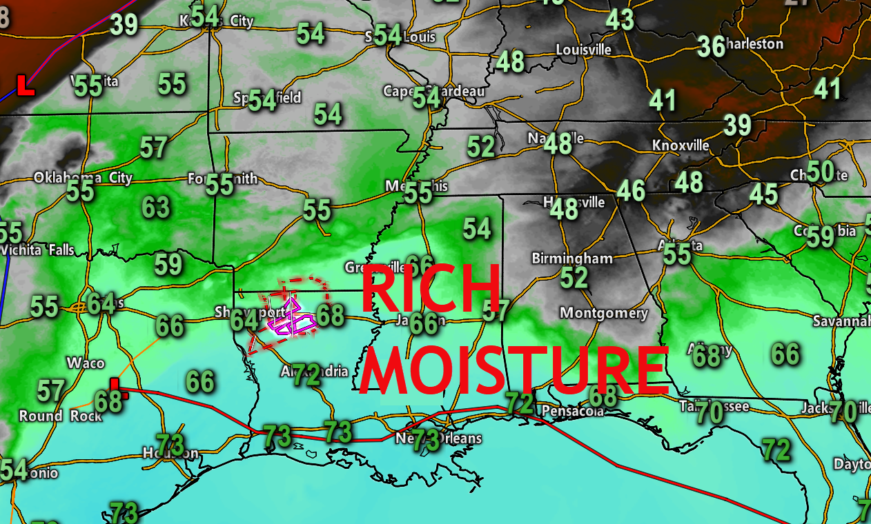
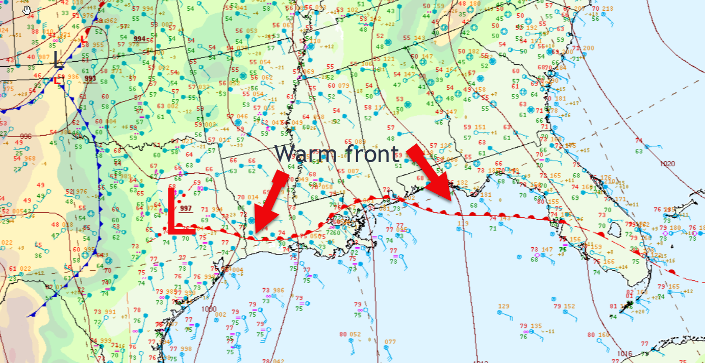
A warm front is draped across the Gulf of Mexico. It is slowly moving northward.
The richest Gulf of Mexico air is south of that warm front. It will remain to our south. Thankfully.
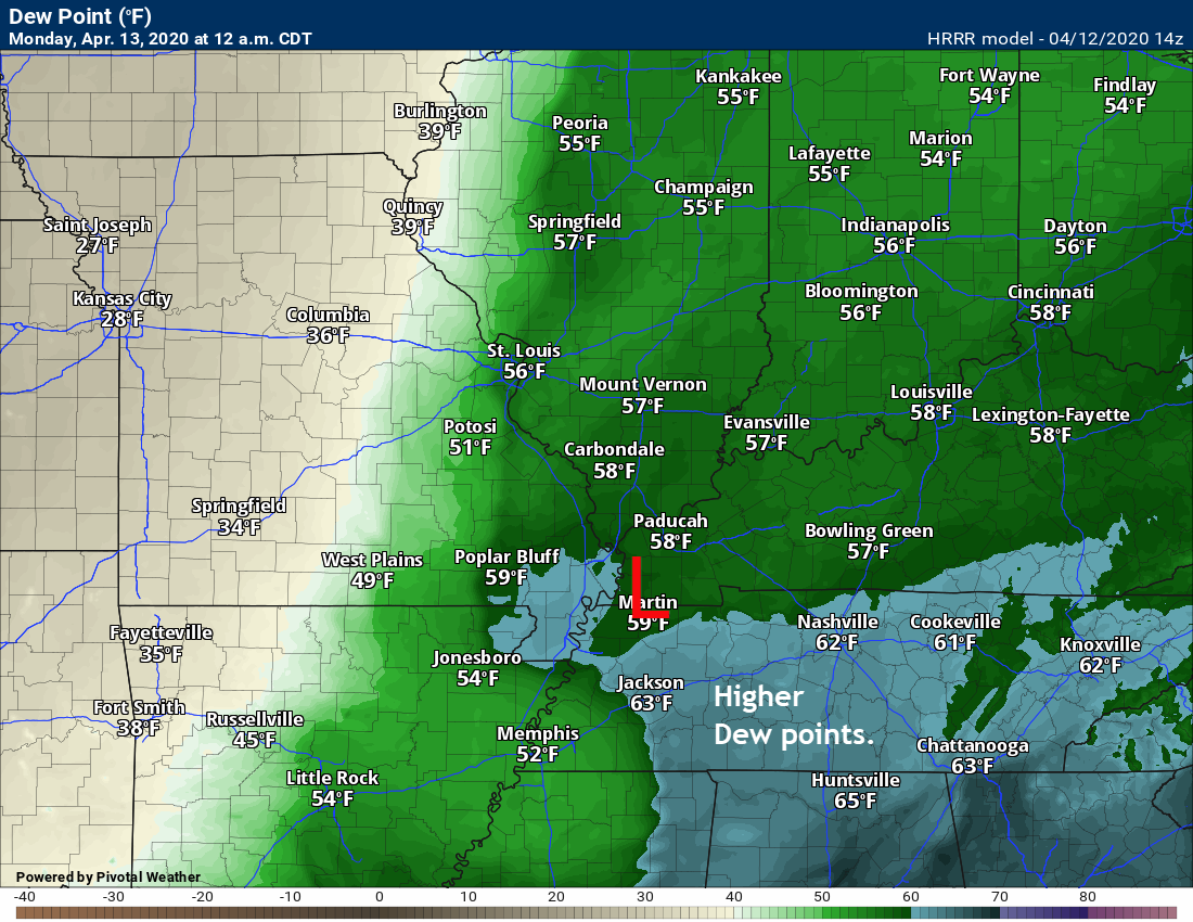
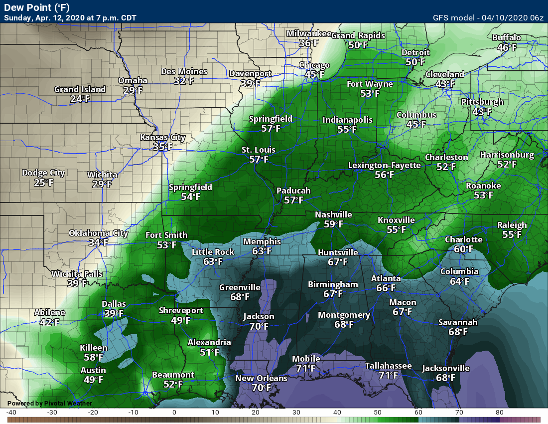
Here was the 10:55 AM dew point map. Remember, when forecasting severe weather, I typically look for 58 degrees and above (dew points).
.
The highest threat of severe thunderstorms is along and south of the warm front. Thus, it is good that it is well south of our area.
That warm front will, however, be moving northward over the coming 12 to 18 hours. It should end up in Tennessee.
.
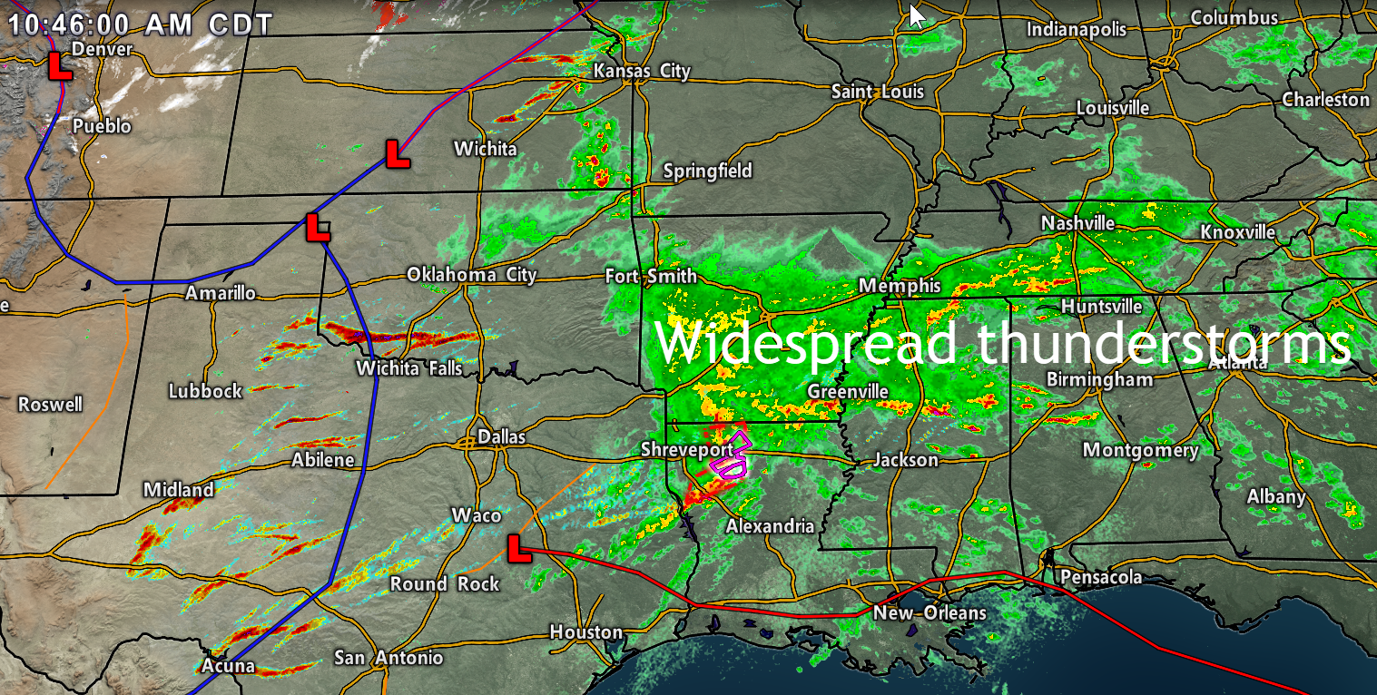
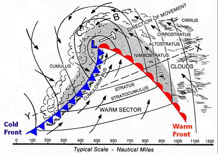
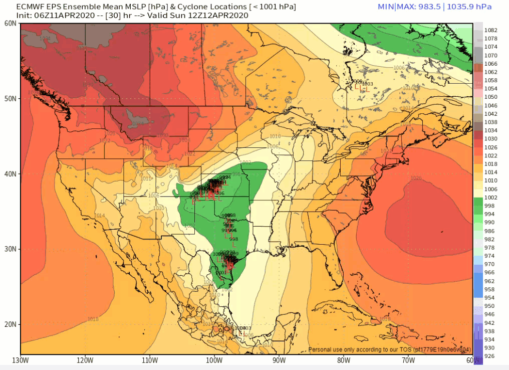
The track of the low -pressure center is key to where severe weather will occur.
Typically, the bulk of the severe weather is to the south and east of the low. Not always, but for the most part. You can have occasions where severe weather occurs to the northwest of the low. We may see some of that today across parts of southwest and central Missouri.
We call that the warm sector of the cyclone.
You can see the L on this map. That is the center of LOW pressure. The blue line with triangles is a cold front. The red line with ovals represents a warm front.
The warmest air is to the south and east of the low. Warm sector. Severe storms are more likely in the warm sector of storm systems.
.
Over the past few days, there has been a question as to the exact track of the low. The model guidance has been tracking it anywhere from as far north as southern Illinois to as far south as western Tennessee. That makes a huge difference in our forecast. It has also made it difficult to forecast what will happen locally.
This is similar to what happens during the winter months. The track of the low is key to who receives rain vs snow. Small adjustments in the track can have massive implications for the eventual forecast outcome!
The low has been trending slowly southward in this morning’s model guidance. The trend has been to push it several counties further south.
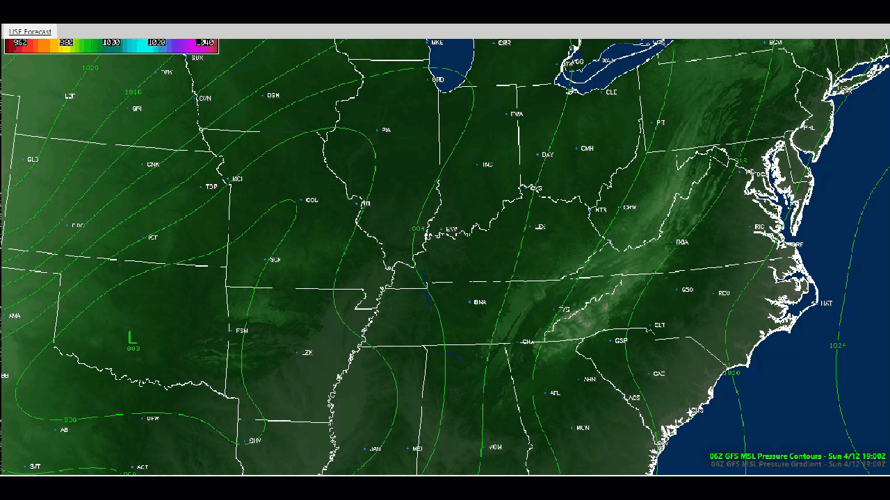
The Hrrr model. You can see the red L along the Kentucky/Tennesse border. That is the low-pressure center.
The Hrrr tracks it into southern Kentucky. It would then continue to deepen and move northeast.
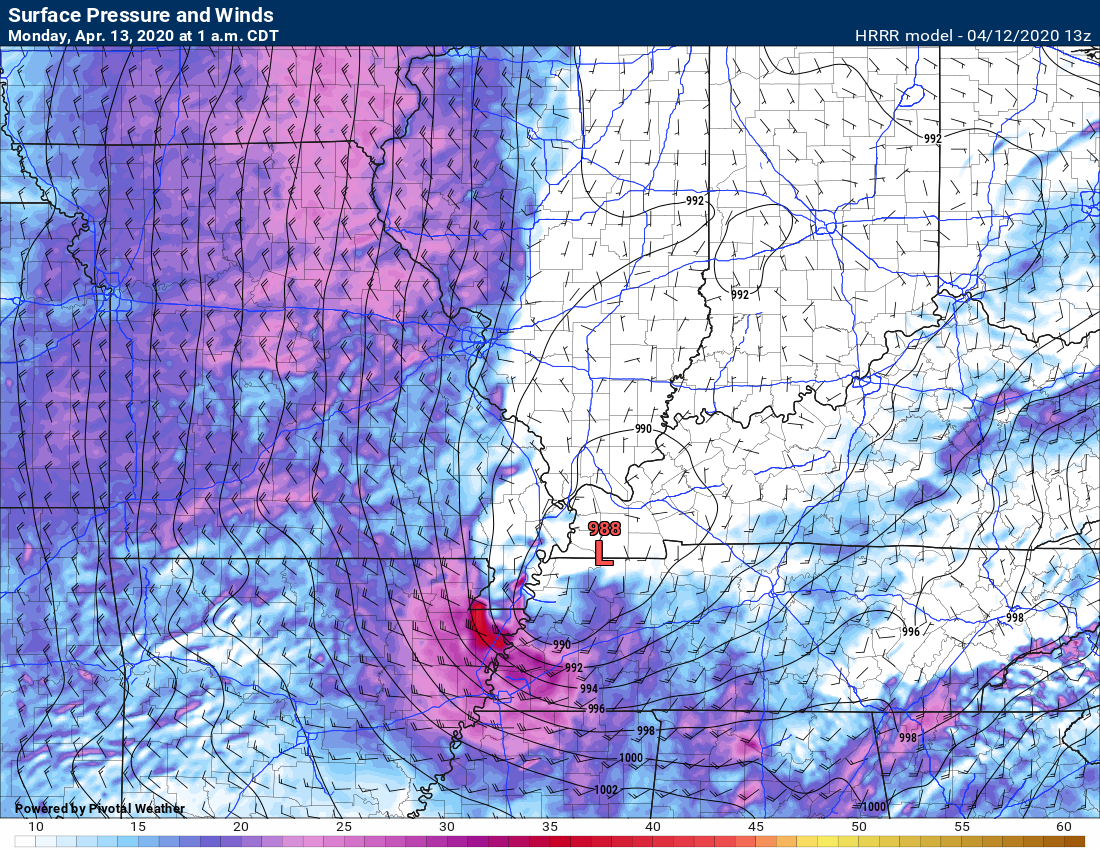
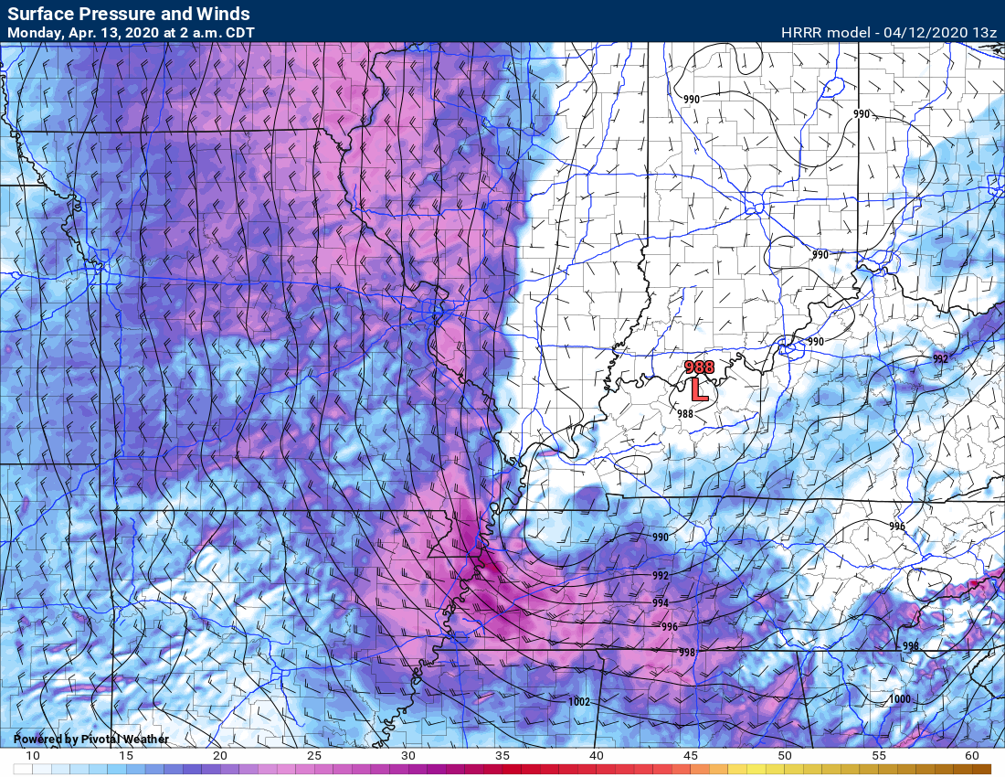
2 AM. The low is moving into Indiana.
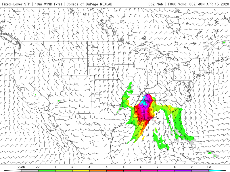
Notice those purple colors in the Missouri Bootheel? Those are high winds behind the low-pressure center. Rapidly rising pressure.
.
Let’s look at some future-cast radars.
The Hrrr model shows one squall line / QLCS line moving through Tennessee this evening.
That is fairly far south and would exclude our region from the risk of severe thunderstorms. That would be good news.
Remember, yesterday, the models had the QLCS squall line in our local area.
Notice the thunderstorms back in Missouri and Oklahoma, as well.
.
Late tonight, the models show another round of storms. Those thunderstorms would accompany the area of low pressure.
I will need to monitor those thunderstorms. There is not much instability to work with. Perhaps a little. Thus, I will keep an eye on that last round of storms.
Keep your Weather Talk app on.
.
SPC WRF model. Future-cast radar. Again, notice the QLCS line of storms in Tennessee. To learn more about QLCS thunderstorms, scroll further down and read the updates from the last couple of days.
The WRF model does bring it a bit further north than the Hrrr model guidance. This is something I will be monitoring throughout the day and evening.
.
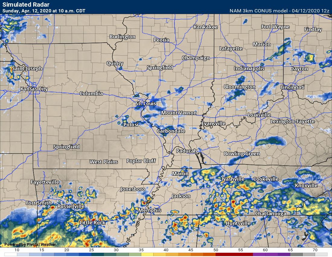
NAM model. It does show a line of thunderstorms impacting portions of western Tennessee and Kentucky later this afternoon into the overnight hours.
.
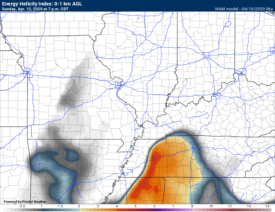
The SREF tornado ingredients. It does show some concern in our region. Primarily across portions of Tennessee and Kentucky.
.
I will monitor the situation throughout the day and update the blog accordingly.
Happy Easter, everyone. Stay safe.
.
Saturday Updates
10:20 AM Update
Highlights:
- Showers and thunderstorms will develop across the region tonight into Sunday night. On and off periods of rain and storms.
- Strong winds will develop Sunday into Monday. Wind gusts above 45 mph are likely.
- I am monitoring the chance of severe weather late Sunday afternoon and especially Sunday night. The main time-frame of concern will be Sunday 6 PM through 3 AM.
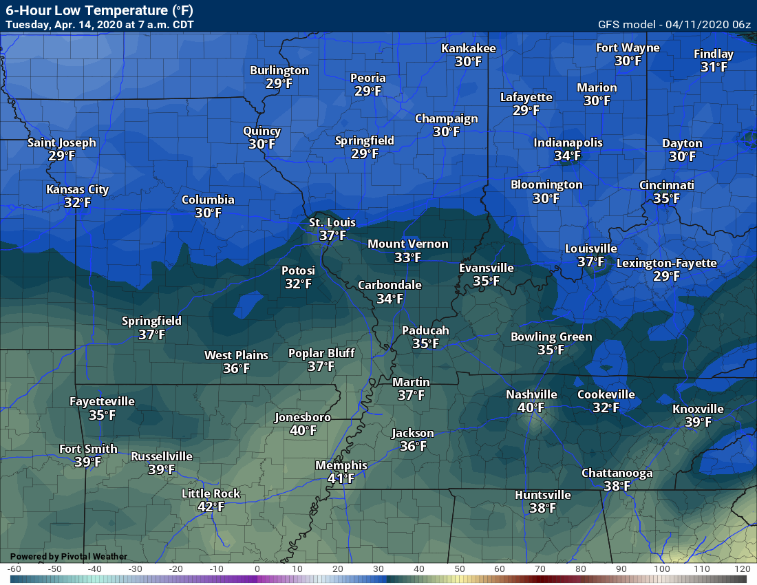
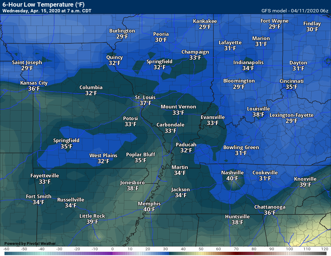
- Frost is possible Monday, Tuesday, and Wednesday night.
.
Forecast analysis.
First, high winds are possible Sunday night into Monday. Wind gusts above 45 mph are likely. This will be in response to the rapidly deepening area of low pressure that will pass to our north.
We call these gradient winds.
Low-pressure centers are surrounded by isobars. What are isobars? Equal line of barometric pressure.
The higher those lines, the stronger the wind gusts. Typically, as a system pulls away, we experience strong winds. Tightening pressure gradient.
You can see the center of low pressure on this animation. Those lines are isobars. See how tightly packed they are? Gradient winds on Sunday night and Monday will be strong.
Click images to enlarge them.
.
Severe Weather Concerns.
A low confidence forecast concerning the chance of severe thunderstorms Sunday afternoon and especially Sunday night. The time-frame of greatest concern will likely be 6 PM through 2 AM.
There are several ingredients that may not develop. Dew points are in question and CAPE.
Dew point is a measure of moisture in the atmosphere. Typically, when forecasting severe weather, one looks for 58-degree dew points and above. The higher the dew points, the greater the chance of severe thunderstorms.
The next ingredient is CAPE. CAPE is basically energy for storms to tap into (to learn more about CAPE scroll further down and read Friday’s update).
If we don’t have CAPE, we don’t have severe weather. It is just that simple.
The NAM shows the bulk of the CAPE remaining to our south.
Click on the animation to enlarge it.
.
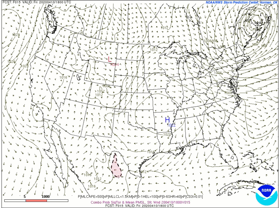
I usually follow the SREF model tornado ingredient trends. This model certainly shows the potential for severe weather.
Click on the animation to enlarge it.
.
I suspect this will be a babysitting system. What does that mean? It means that the risk of severe weather will be HIGHLY conditional on these ingredients developing. I will need to closely monitor the radar and each storm that develops.
Often times, systems like this, need to be closely monitored. Wind shear will be about as high as it can be. Wind shear is another ingredient meteorologists look for when forecasting severe thunderstorms. There will be no shortage of wind shear!
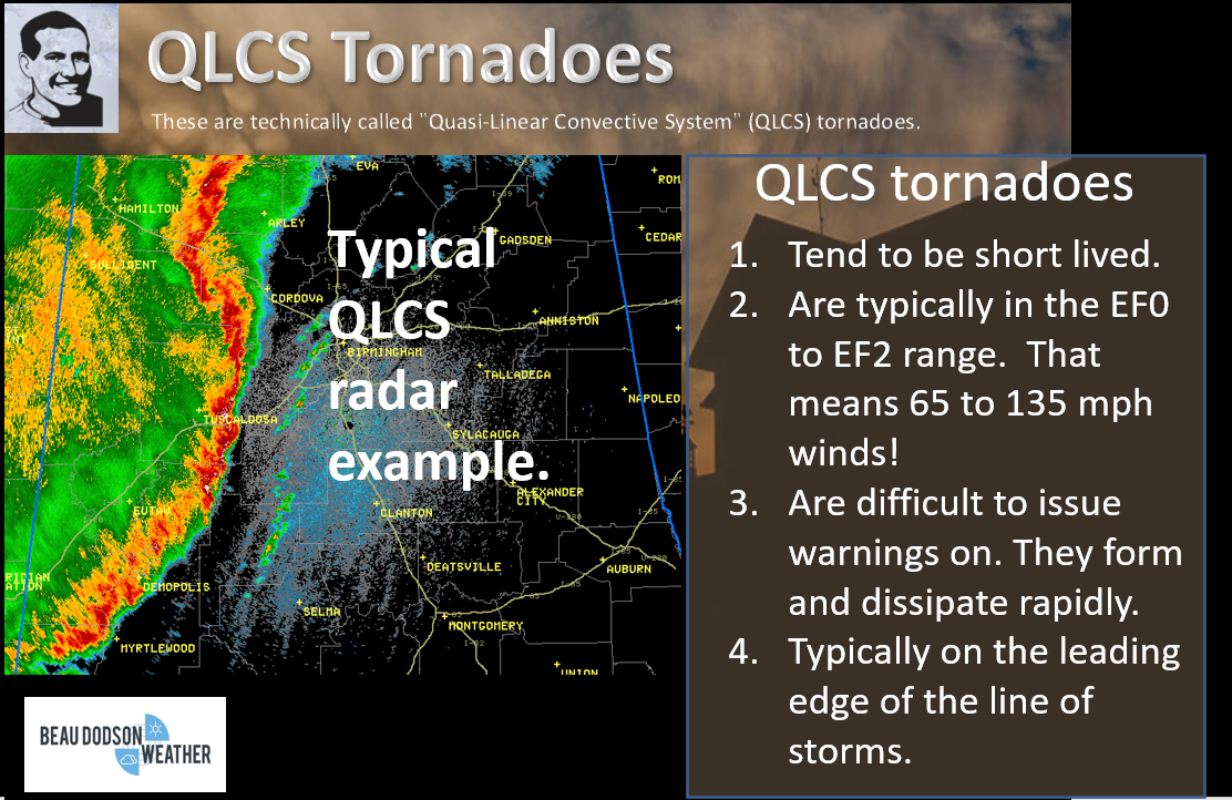
That means that thunderstorms could quickly become severe with damaging wind and even a tornado. Even a small amount of CAPE will cause problems. Low CAPE and high shear events tend to produce QLCS tornadoes. These are short-lived tornadoes that rapidly develop and dissipate. They are difficult to issue warnings on. To learn more about QLCS tornadoes, scroll down and read yesterday’s update.\
.
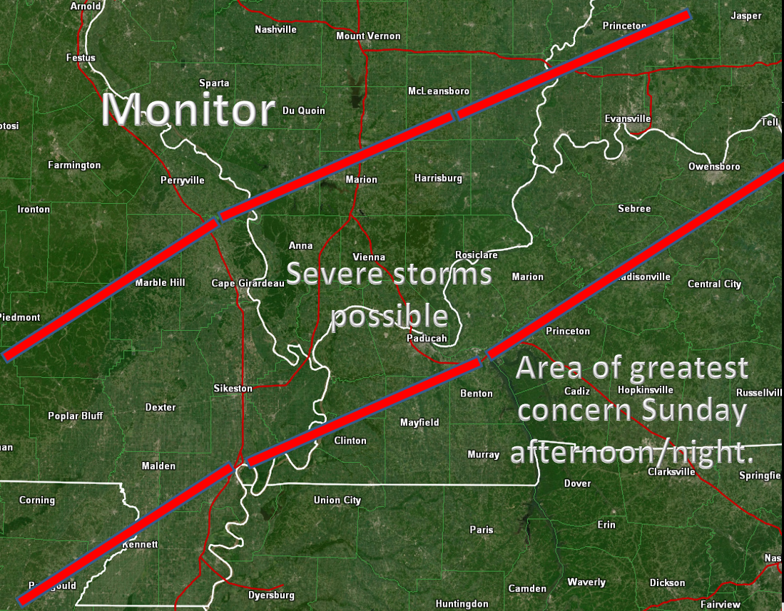
Bottom line:
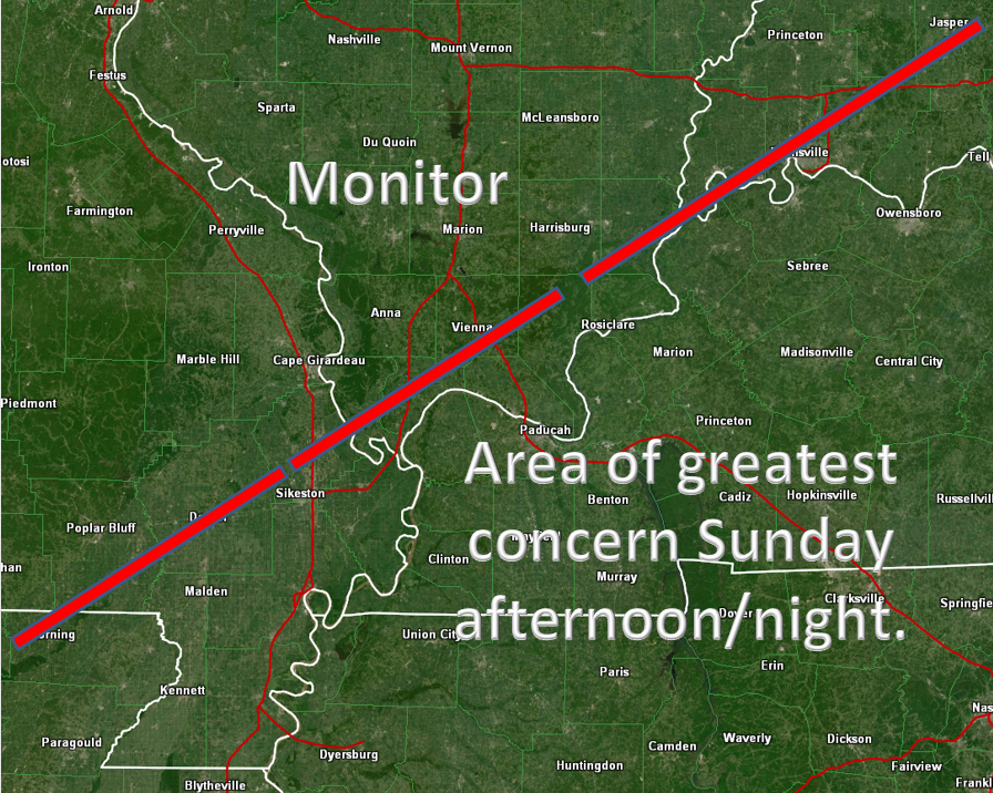
Severe storms are possible Sunday afternoon and especially Sunday night. The highest chance of severe weather will be across the Missouri Bootheel into western Tennessee and across portions of western Kentucky. See the graphics below.
Chances of severe weather, in our local area, will decrease as you move further north/northwest.
Here are the latest Storm Prediction Center graphics. This shows you where they believe the risk of tornadoes, damaging wind, and hail will occur. The numbers spike well to our south.
Click on the images to enlarge them.
Tornado Risk
Damaging wind risk
Hail risk
.
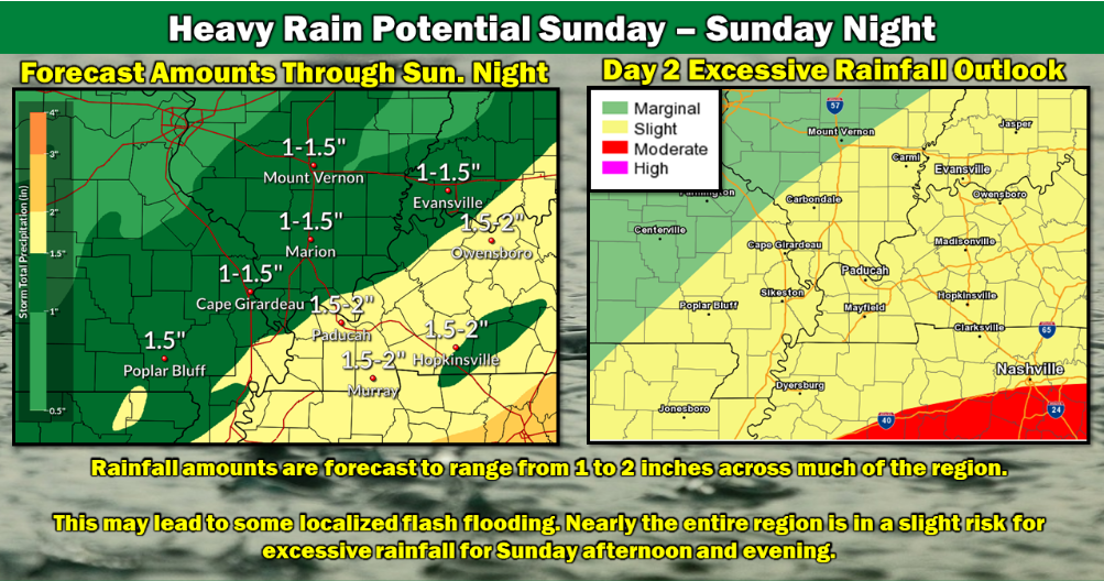
Locally heavy rain will also be a concern. One to two inches of rain will likely fall across parts of the Missouri Bootheel, western Tennessee, and western Kentucky. Totals will be less as you move further north and west.
This amount of rain could temporarily cause some flooding issues. Poor drainage areas would have problems. Some roadways may flood.
The Paducah, Kentucky, National Weather Service posted this graphic.
.
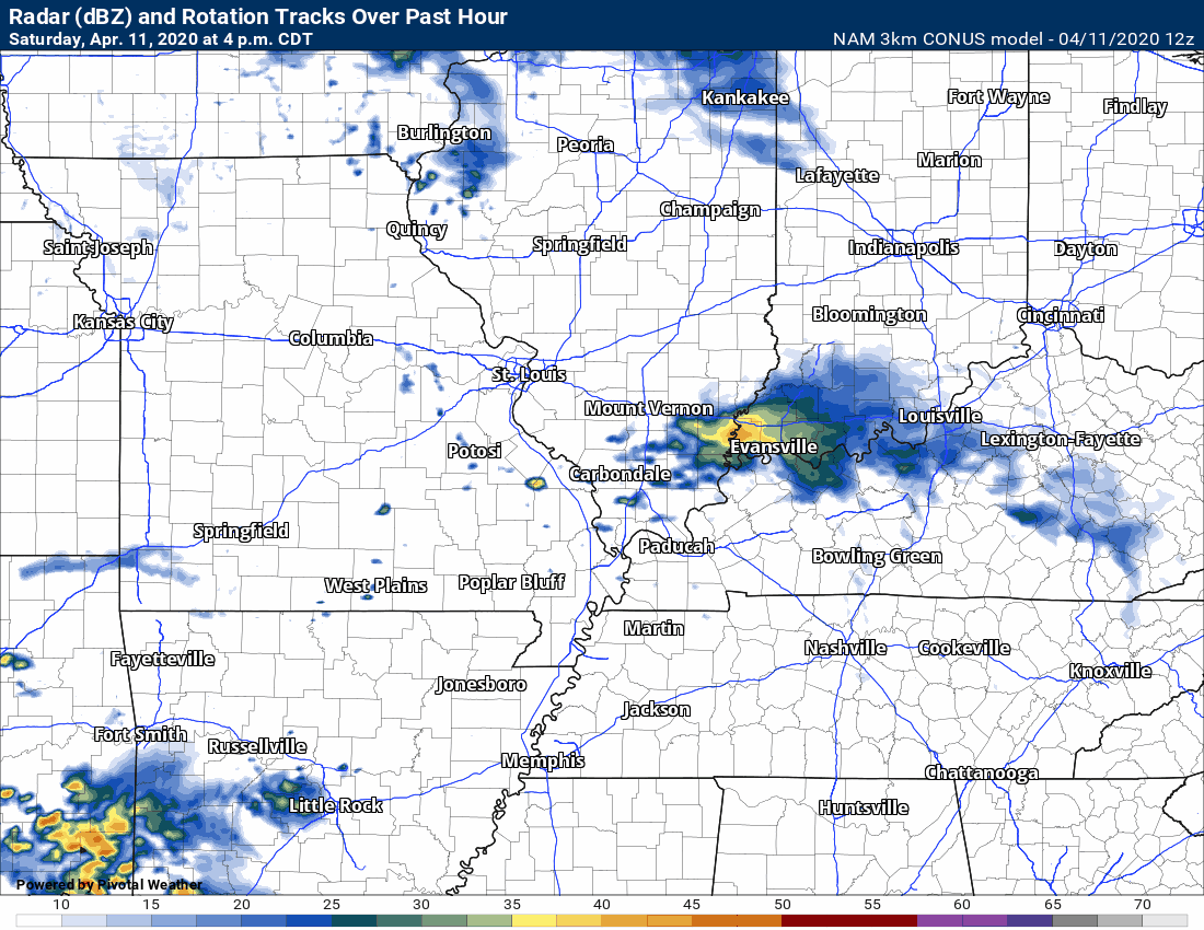
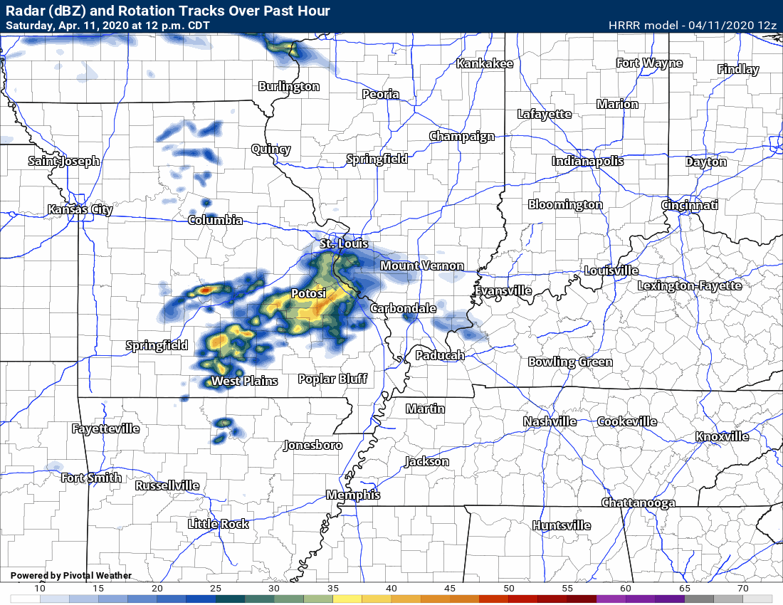
Here are some of the Saturday morning future-cast radars.
NAM 3K model.
The NAM 3K model develops a QLCS squall line. A line of storms.
The line develops in AR and TN after 7 PM Sunday. It races northeast at 60+ mph. This is the model that is most concerning. IF it verifies then we will have severe weather warnings.
.
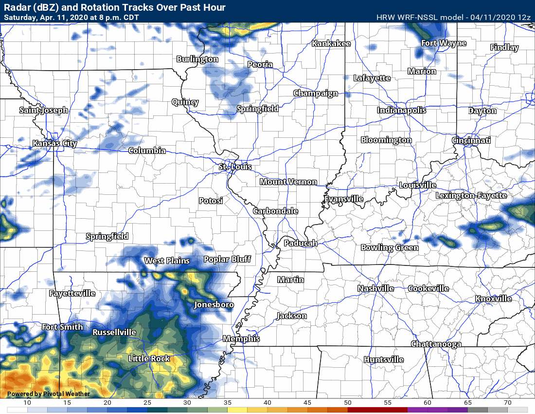
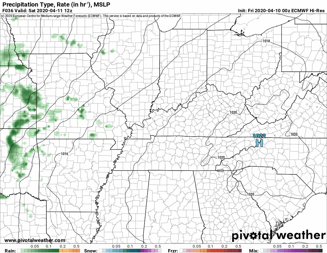
The SPC WRF model is not quite as concerning as the NAM model.
It keeps the greater threat of severe weather to our south and east.
.
The Hrrr model is the odd man out. It develops multiple lines of storms. One late at night (after midnight).
For now, this model is the outlier. Meaning, it does not have much support. I will monitor trends.
.
The Memphis, Tennessee, National Weather Service posted this video
.
This is the track of the area of low pressure. This low-pressure center will rapidly deepen Sunday afternoon into Monday. It will race into the Great Lakes.
Blizzard conditions are possible on the west side of the low (Wisconsin into Canada). A late-season winter storm.
.
Colder air sweeps in behind the cold front.
.
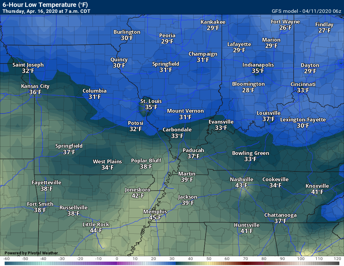
I expect frost/freeze advisories/warnings next week.
Tuesday morning lows (clouds and wind may limit frost on Tuesday morning)
Wednesday morning
Thursday morning
9 AM
A full update will be posted when the morning data arrives.
Here is my latest threat map. All modes of severe weather will be possible.
I am monitoring what happens to our south. If widespread storms develop to our south then that could rob us of higher moisture levels.
Lower moisture levels would reduce our severe weather chances. Thus, this is a conditional severe weather risk.
There remain questions about CAPE. CAPE levels may be quite low. Without CAPE, you can’t have severe weather. There has to be some CAPE.
That is the biggest question in the current forecast. CAPE levels.
This is a conditional risk. What does that mean? It means that in order to have severe weather we will need a few ingredients to come together that are currently questionable.
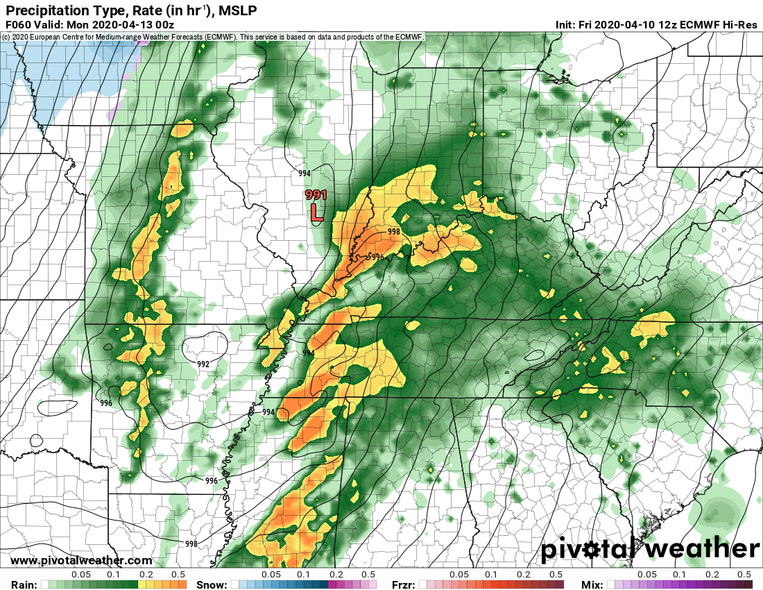
The NAM future-cast radar. NAM is a model. It shows a QLCS line of storms Sunday night.
I continue to focus on the Missouri Bootheel into parts of Tennessee and Kentucky for the highest threat. That does not mean other areas are out of the woods.
The Memphis, Tennessee, National Weather Service posted this video
And this model (this shows our southern counties only). Notice that line that forms towards the end and moves northeast. That is the QLCS squall line.
Scroll down further in the blog to read more about QLCS systems.
.
5 PM Update
I am increasingly concerned about a QLCS event on Sunday evening/night. Storms would move SW to NE at speeds greater than 60 mph.
What is a QLCS event?
Here is the NAM 3K future-cast radar. It shows a squall line moving out of Arkansas and Tennessee. Movement is NE.
This could produce wind damage and even tornadoes.
This event is still two days out. Thus, adjustments are likely.
.
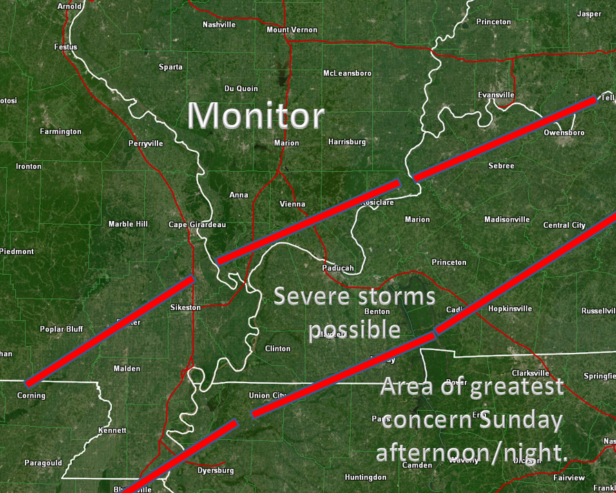
2 PM update
This is the area of concern on Sunday. South and east of the red line. Areas to the north and west should monitor updates, as well.
The concern will be thunderstorms with damaging wind and perhaps even a tornado.
This is a conditional risk. What does that mean? It means that in order to have severe weather we will need a few ingredients to come together that are currently questionable.
The main one being CAPE. Think of CAPE as energy for storms to tap into. Without CAPE, we can’t have severe weather.
If clouds and rain linger on Sunday, then the risk of severe weather may be lower. The CAPE would be lower..
We need to monitor the situation and be prepared Sunday afternoon and night for severe storms.
.
The EC model is taking the low a bit further north and west. That places more of our region in the warm sector of the storm system.
The warm sector is south and east of the low-pressure center. That is usually where severe weather occurs.
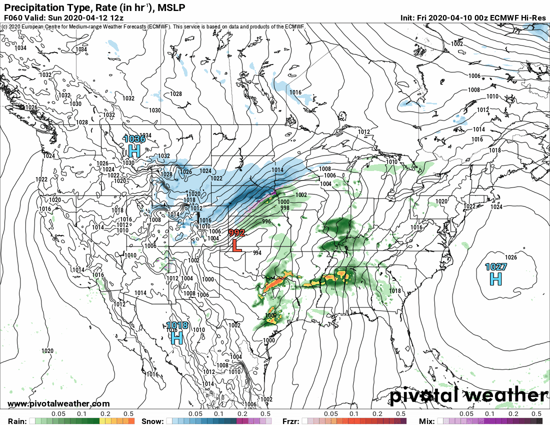
You can see the 992 mb low over southeast Missouri on this graphic. This would be during the evening hours Sunday.
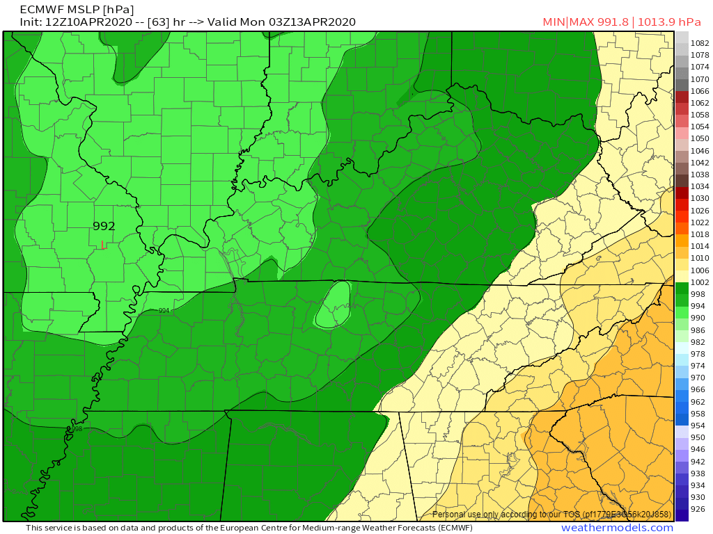
Another image
.
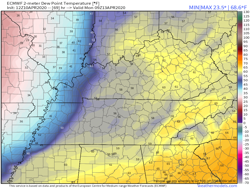
Let’s take a look at the dew point forecast. Remember, dew point is a measure of moisture in the atmosphere. Higher dew points equal more fuel for thunderstorms to tap into.
When forecasting severe weather, I look for dew points from 58 degrees and above.
7 PM Sunday dew points. You can see moisture pooling south of the warm front.
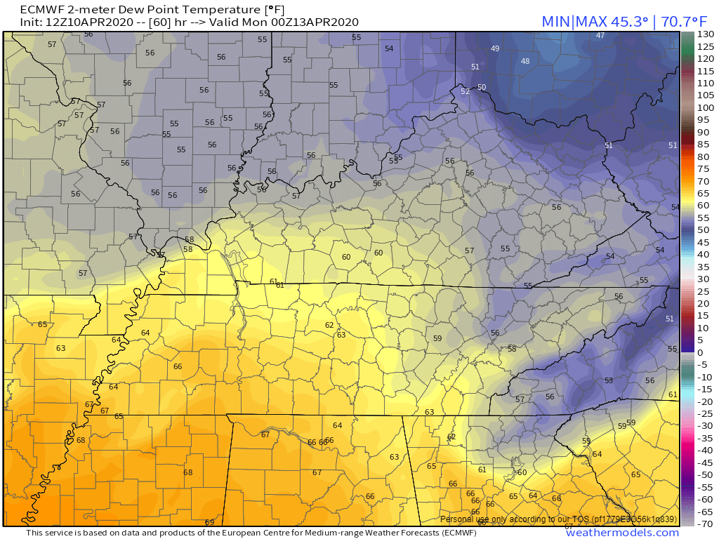
10 PM Sunday
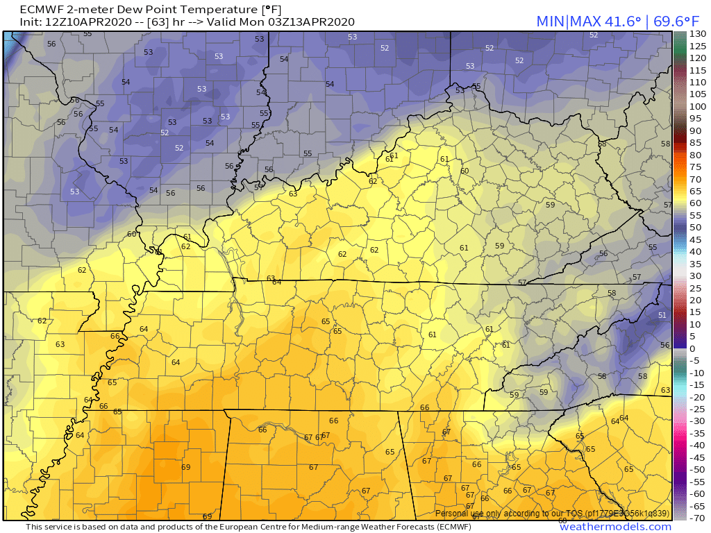
1 AM Sunday
See the cold front advancing from the west? A sharp dropoff in the dew point temperatures.
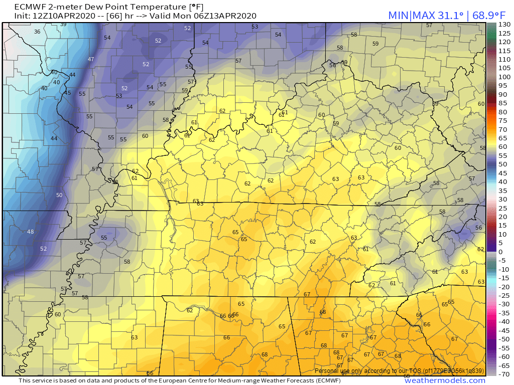
4 AM Sunday
.
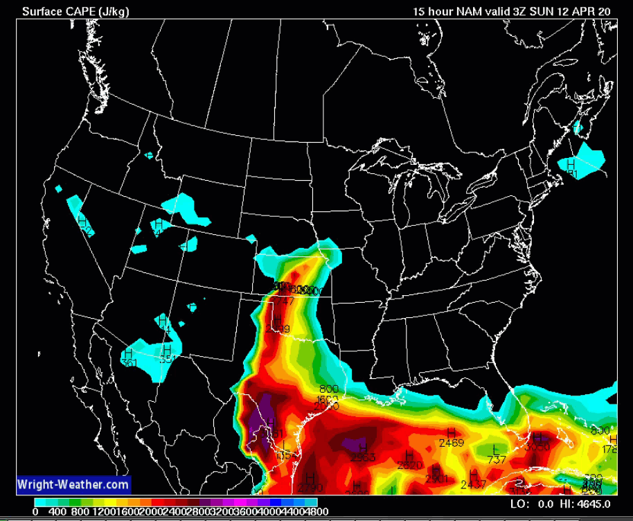
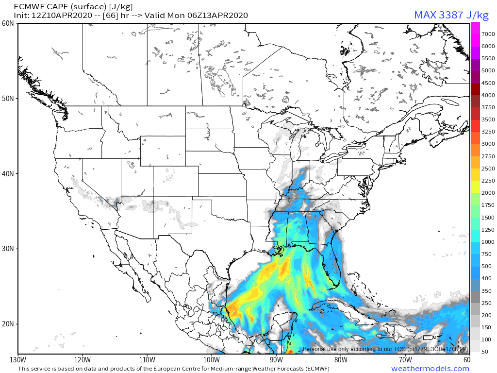
What is CAPE? Think of CAPE as energy/fuel that feeds thunderstorm growth.
Let’s look at the EC model and CAPE numbers. CAPE is a big question mark on Sunday. Widespread rain and clouds would keep CAPE numbers low.
4 PM Sunday. You can see CAPE all the way into Iowa.
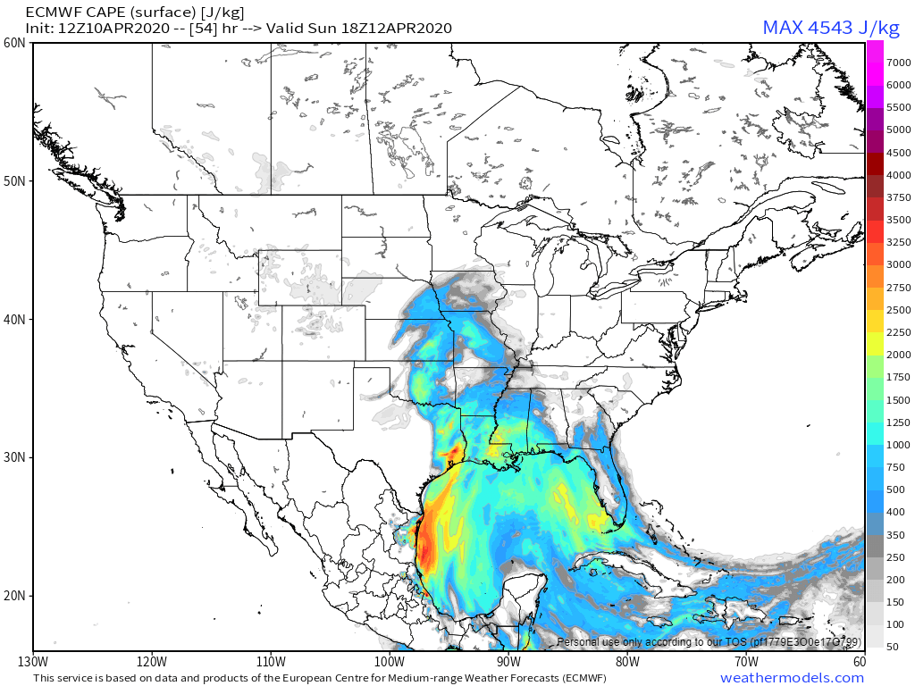
7 PM Sunday
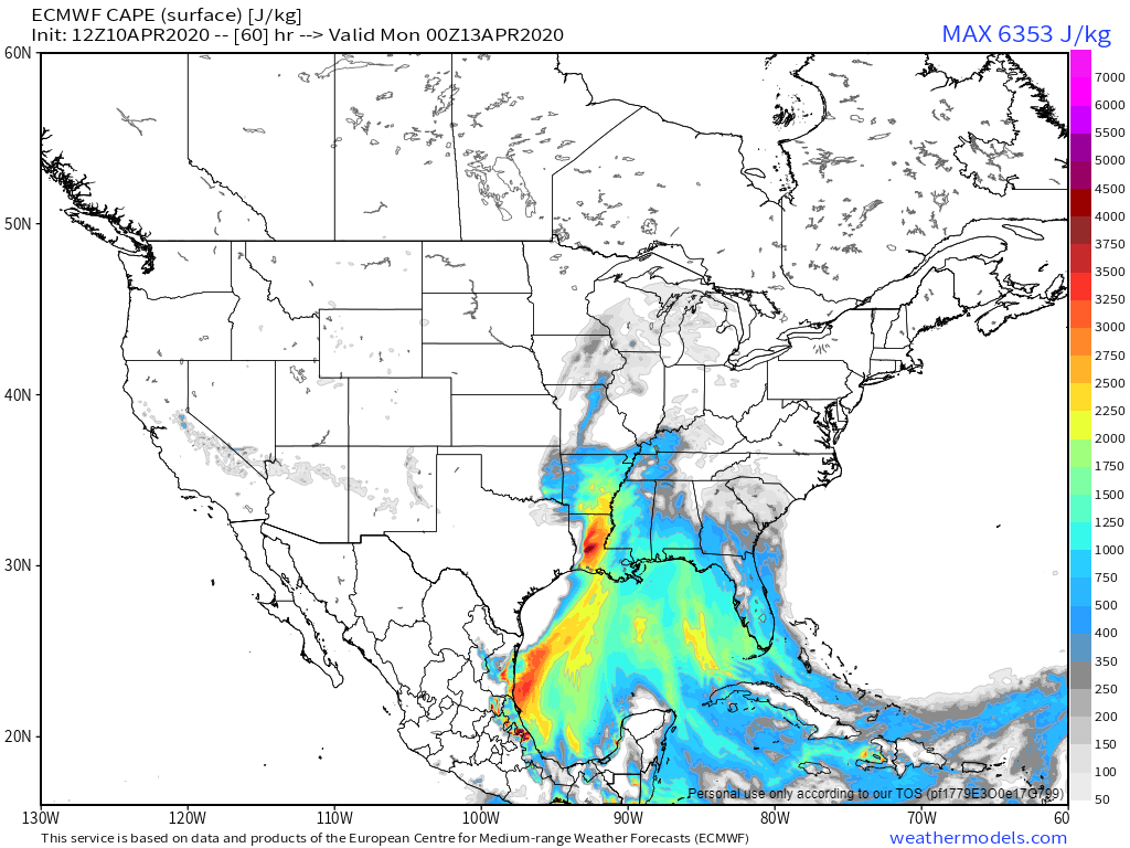
10 PM Monday. We have some CAPE to work with. This is one part of the forecast that I will be closely monitoring. It will make all the difference when it comes to severe weather threats.
.
9 AM update
The latest NAM model brings a squall line into parts of western Kentucky.
The greatest severe weather concern will likely be across TN/KY (speaking locally, only).
.
The severe weather blog will be updated a couple of times today and on Saturday. It will be updated MORE frequently on Sunday (the day of the potential event).
We have a conditional risk of severe weather on Sunday afternoon and night.
What does conditional mean? It means that if CAPE does not develop then severe weather won’t occur. CAPE is energy for thunderstorms to tap into.
Sunday is forecast to be cloudy and rainy. That may prevent CAPE from forming.
With that said, it would not take much in the way of CAPE to cause issues. Monitor updates.
Widespread showers and thunderstorms will develop Saturday night into Sunday night.
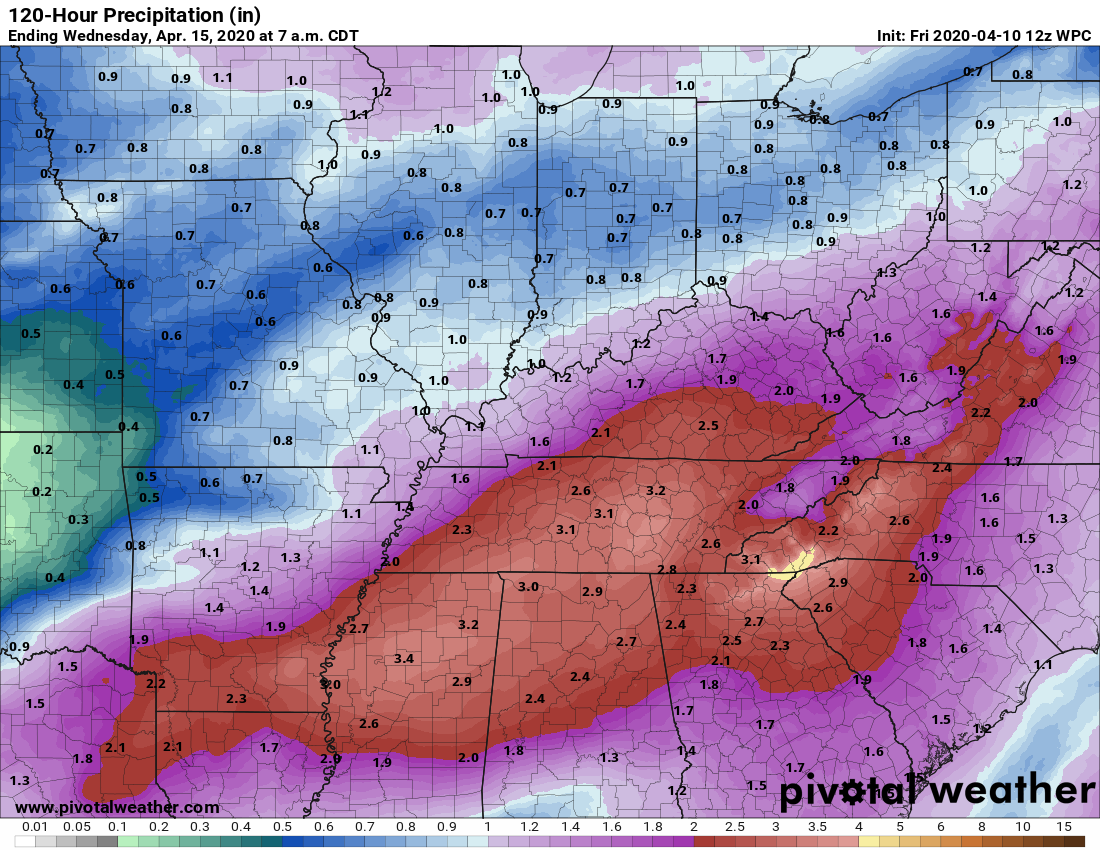
It appears the system will track far enough north that heavy rain will become a concern on Sunday/Sunday night. The heaviest rain will fall across western Tennessee and western Kentucky. Some locations could top two inches of rain.
This will cause some flooding of poor drainage areas. Some roads may flood. Avoid flooded roadways, as always.
I am monitoring the risk of severe weather.
A severe weather outbreak is likely across the southern United States. Tornadoes, some strong to violent, will be possible. This is a dangerous set-up for the Southland. Let’s hope it underperforms.
The Storm Prediction Center has outlined a multi-day event. Tomorrow, Sunday, and Monday.
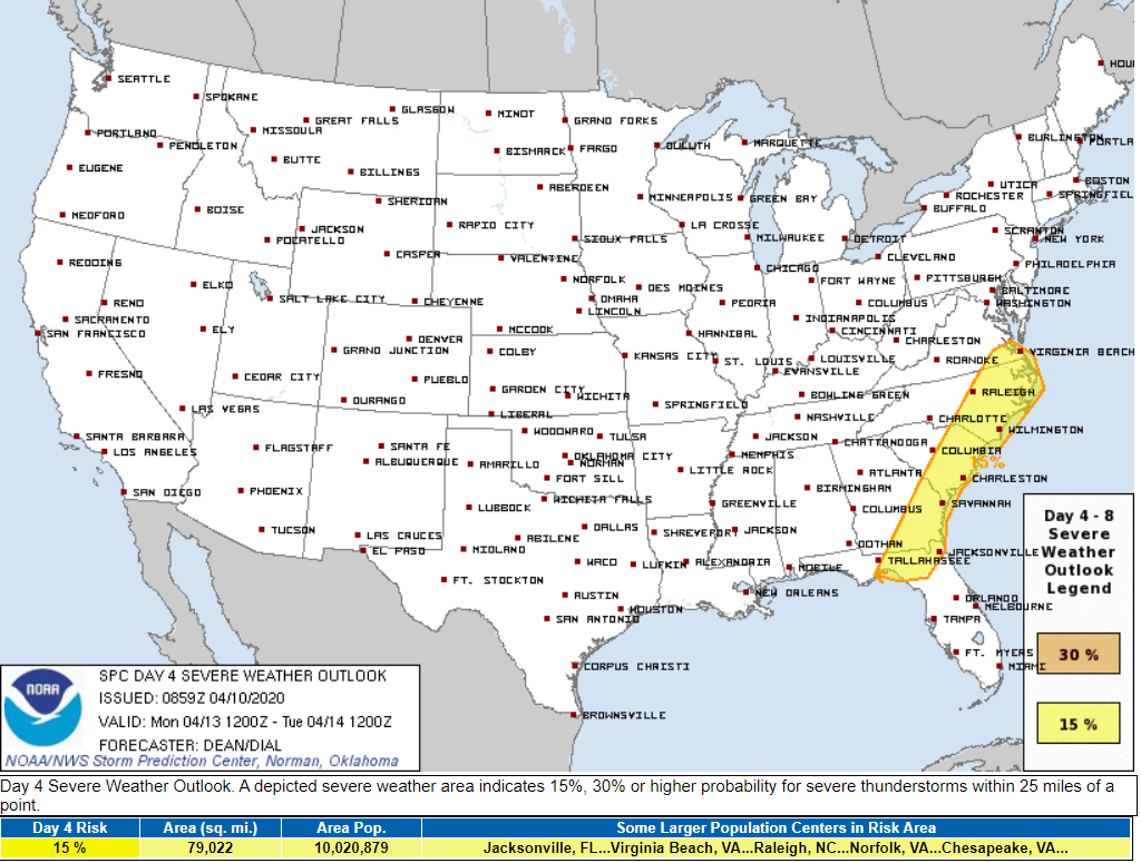
Saturday’s outlook for severe storms. We are in the light green zone. That simply means that lightning is possible.
Click the images to enlarge them.
Sunday outlook (below)
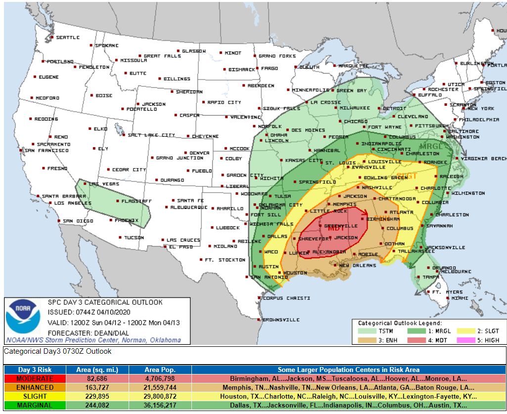
And Monday
.
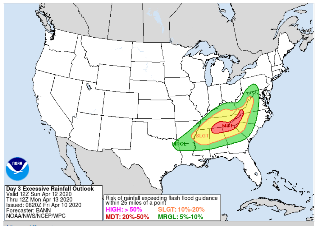
The WPC has also outlined a portion of our region for excessive rainfall. What does that mean? It simply means locally heavy rain is in the forecast.
.
I continue to monitor the conditional risk of severe weather in our local area. The conditional risk arrives Sunday afternoon and night.
First, what does conditional risk mean? It means that certain elements must come together in order for us to have severe thunderstorms.
Wind fields will be very strong with this particular system. What will be lacking, locally, will be instability and higher dew points (moisture to fuel storms).
This is a HIGHLY conditional severe weather risk. There is a strong possibility that our region avoids severe weather. With that said, we need to discuss the potential.
It would not take much in the way of CAPE (think of CAPE as energy for storms to tap into) to cause problems. Higher CAPE values would certainly equal a higher risk of tornadoes and damaging wind.
There will be a significant outbreak of tornadoes to our south. Areas from Louisiana into Mississippi, Alabama, Georgia, southern Tennessee, and the Carolina’s will likely have numerous tornadoes. Some strong long-track tornadoes are likely. Strong meaning a higher EF rating. EF is the scale that meteorologists use to rate tornado damage and wind speed.
Whether that pushes northward is still a question. Thus, this is a highly conditional severe weather outlook. We will be on the northern fringe of this event.
Please monitor updates Sunday afternoon and night. Since it is a holiday weekend, I will go ahead and activate the live severe weather blog.
SREF tornado ingredients animation takes us through tomorrow, Sunday, and Monday. You can see the bullseye over the southlands on Sunday.
That is where the tornado risk will be highest. Long-tracked tornadoes can’t be ruled out. If you have friends in the risk zone, then please let them know. In that area, there will be numerous tornado watches and warnings.
When forecasting severe thunderstorms, I like to look for dew points in the 58 to 60+ range. Higher dew points would mean more fuel for thunderstorms to tap into.
Dew point is a measure of moisture in the atmosphere. More moisture = more fuel for storms.
The higher dew points will likely remain in Tennessee and perhaps into Kentucky. This will need to be monitored.
If the system tracks further north and west then those higher dew points will push further into our local area.\
The NAM models dew point forecast for Sunday afternoon/evening.
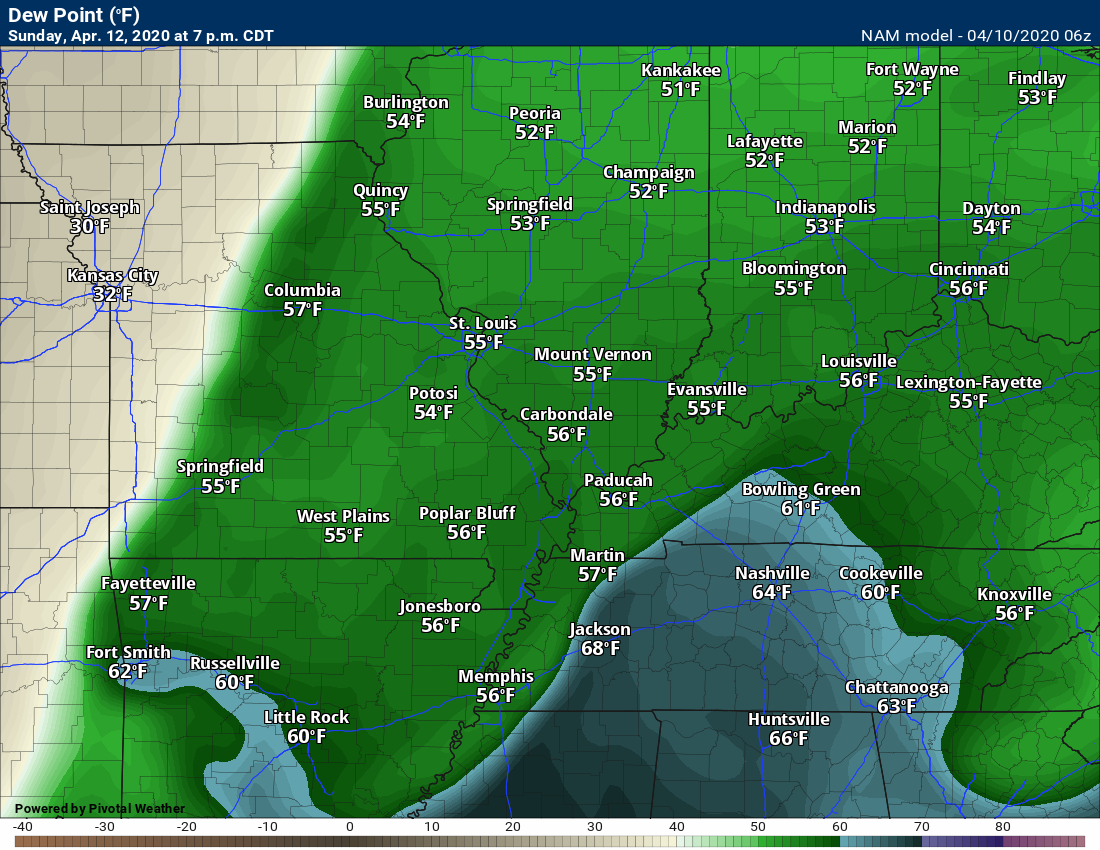
The GFS models dew point forecast for Sunday afternoon/evening.
.
CAPE is energy for thunderstorms to tap into. Ingredients for CAPE include temperature and dew point. Sunny days typically have higher CAPE values. That is because temperatures tend to be higher.
CAPE, with this event, is marginal. With that said, it won’t take much in the way of CAPE to cause issues. Why? Because upper level winds will be strong (wind shear). That can offset low CAPE numbers. Wind shear is an ingredient in severe weather forecasting. Shear means the wind turns with height and increases in speed with height.
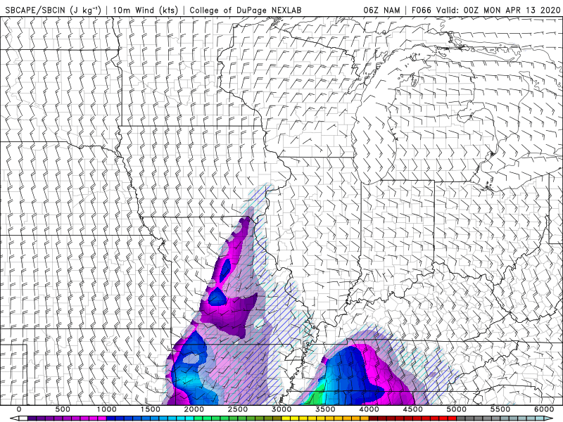
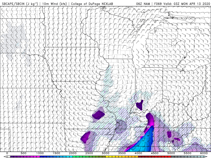
EHI (spin in the atmosphere) will be higher to our south and east. It will be close. We need to monitor this.
.
Rain totals will range from 0.80″ over our northwest counties up to two inches around Hopkinsville.
Thunderstorms, anywhere in the region, can always enhance rain totals. Keep that in mind, as always.
.
Check out this storm. It winds up as it pulls through our region. Deepens over the Ohio Valley. It eventually moves into Canada.
That blue zone is heavy snow. Blizzard conditions? That is certainly possible across a portion of the storm track.
Those black lines are isobars. Equal lines of pressure. TIGHT isobars equal high wind. These are tightly packed isobars.
We will have strong and gusty wind on Sunday and Monday. Gusts above 40 mph will likely occur.
 .
.
Again, as a reminder, these are models. They are never 100% accurate. Take the general idea from them.
What should I take from these?
- The general idea and not specifics. Models usually do well with the generalities.
- The time-stamp is located in the upper left corner.
.
What am I looking at?
You are looking at different models. Meteorologists use many different models to forecast the weather. All models are wrong. Some are more wrong than others. Meteorologists have to make a forecast based on the guidance/models.
I show you these so you can see what the different models are showing as far as precipitation. If most of the models agree, then the confidence in the final weather forecast increases.
.
This animation is the EC model.
This animation shows you what radar might look like as the next system pulls through the region. It is a future-cast radar.
Green is rain. Blue is snow. Pink and red represent sleet and freezing rain.
Time-stamp upper left. Click the animation to enlarge it.
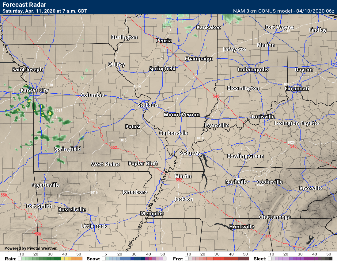
This animation is the 3K American Model.
This animation shows you what radar might look like as the next system pulls through the region. It is a future-cast radar.
Green is rain. Blue is snow. Pink and red represent sleet and freezing rain.
Time-stamp upper left. Click the animation to enlarge it.
.
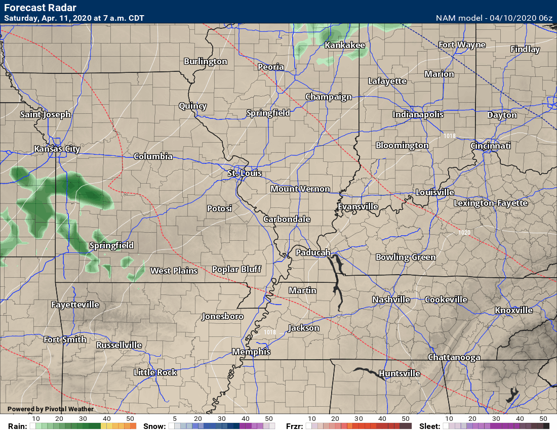
This next animation is the NAM American Model.
This animation shows you what radar might look like as the system pulls through the region. It is a future-cast radar.
Green is rain. Blue is snow. Pink and red represent sleet and freezing rain.
Time-stamp upper left. Click the animation to enlarge it.
.
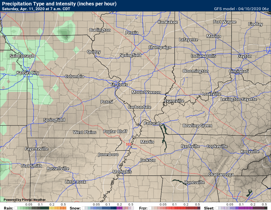
This next animation is the GFS American Model.
This animation shows you what radar might look like as the system pulls through the region. It is a future-cast radar.
Green is rain. Blue is snow. Pink and red represent sleet and freezing rain.
Time-stamp upper left. Click the animation to enlarge it.
Radars
Interactive city-view radars
http://weatherobservatory.com/weather-radar.htm
A third backup radar
https://weathertalk.com/morani
Clickable watches and warnings can be viewed on the local city-view interactive radars (link above). Be sure and turn on the warnings above the local radars.
A new regional radar we offer
https://imagery.weathertalk.com/prx/RadarLoop.mp4
Lightning data
https://wtalk.co/7QT7WHKU
.
Storm Prediction Center severe weather outlook.
Here is the latest Storm Prediction Center outlook. Remember, don’t pay too much attention to the different colors. Focus on the actual forecast. The forecast is for a few severe thunderstorms.
The black outline is our local area.
Light green is where thunderstorms may occur but should be below severe levels.
Dark green is a level one risk. Yellow is a level two risk. Orange is a level three (enhanced) risk. Red is a level four (moderate) risk. Pink is a level five (high) risk.
One is the lowest risk. Five is the highest risk.
A severe storm is one that produces 58 mph wind or higher, quarter size hail, and/or a tornado.

.
Tomorrow’s severe weather outlook.

Not receiving app/text messages?
USE THE APP. ATT and Verizon are slowing or stopping the text messages.
Make sure you have the correct app/text options turned on. Find those under the personal notification settings tab at www.weathertalk.com. Red is off. Green is on.
Subscribers, PLEASE USE THE APP. ATT and Verizon are not reliable during severe weather. They are delaying text messages.
The app is under WeatherTalk in the app store.

Apple users click here

Android users click here
.

Live lightning data: Click here.