We have some great sponsors for the Weather Talk Blog. Please support them when you have the opportunity.
Milner and Orr Funeral Home and Cremation Services located in Paducah, Kentucky and three other western Kentucky towns – at Milner and Orr they believe in families helping families. You can find Milner and Orr on Facebook, as well.
![]()

This forecast update covers far southern Illinois, far southeast Missouri, and far western Kentucky. See the coverage map on the right side of the blog.
Remember that weather evolves. Check back frequently for updates, especially during active weather.
The forecast numbers below may vary quite a bit across the region. These are averages.
Saturday – A mix of sun and clouds. Pleasant. Highs from 66 to 72 degrees. Northeast winds at 10 mph. My confidence in this part of the forecast verifying is high
Should I cancel my outdoor plans? No
Saturday night – Mostly clear and cool. Lows in the 40’s. East winds at 5 mph. My confidence in this part of the forecast verifying is high
Should I cancel my outdoor plans? No
Sunday – Mostly sunny during the morning. Some increase in clouds possible late in the day. Pleasant. Highs will be in the 70’s. Southeast winds at 10-15 mph. Gusts above 15 mph possible. My confidence in this part of the forecast verifying is high
Should I cancel my outdoor plans? No
Sunday night – A chance for showers and thunderstorms (esp late at night). Lows from 58 to 64 degrees. South winds at 10 mph. My confidence in this part of the forecast verifying is high
Should I cancel my outdoor plans? Check radars
Monday – A good chance for showers and thunderstorms. A heavy downpour possible. Highs from 68 to 75 degrees. My confidence in this part of the forecast verifying is high
Should I cancel my outdoor plans? Have a plan B. It might rain.

Current Temperatures Around The Local Area


Don’t forget to check out the Southern Illinois Weather Observatory web-site for weather maps, tower cams, scanner feeds, radars, and much more! Click here

An explanation of what is happening in the atmosphere over the coming days…
Highlights
1. Calm weather today and tonight!
2. Calm weather for most of Sunday.
3. Rain and storm chances (not severe) return on Sunday night and Monday.
4. Unsettled week with on and off rain chances. But, does not look as bad as it did at one time. Thinking the biggest rain totals stay south of our region.
What is the value of instant information? I don’t know if you follow me on the Beau Dodson Weather Facebook page, but if you do then you might notice that I do Severe Weather Now-cast threads. What are these? These are hyper-updated threads of information.
For example – this is the one posted on Thursday night. See the flow of information? Quick/instant/questions being answered instantly.
Thursday Nights Severe Weather Thread Click HERE
Before the NWS issued tornado warnings I was telling people that a tornado was possible on a couple of storms in Cape Girardeau County, MO. Now, the NWS does a GREAT job of getting warnings out, but sometimes it takes a few minutes to get a warning into the system. And, sometimes I see something that they do not. Sometimes they see something that I miss. That is the nature of weather.
On Thursday night I posted this
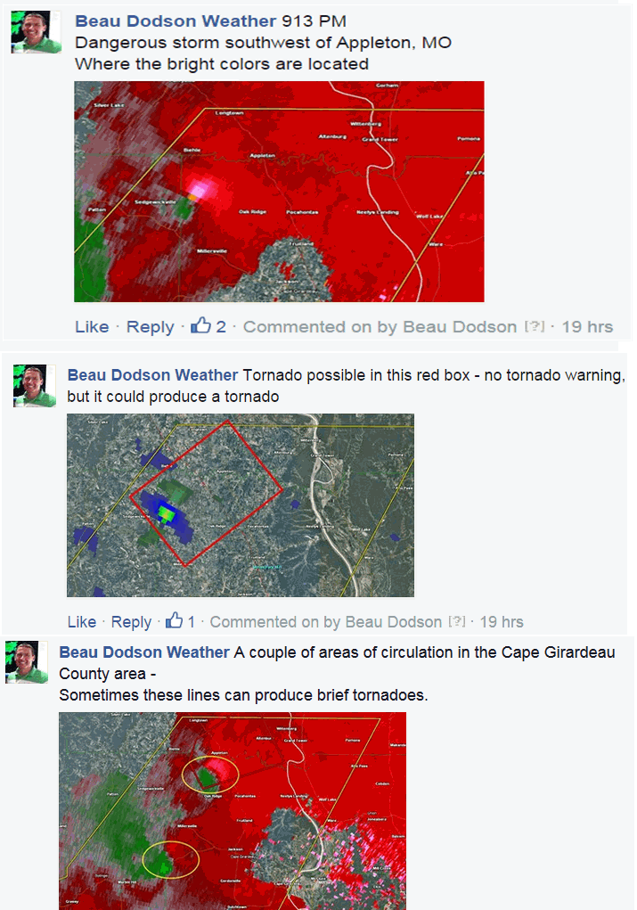
It ends up there were 2 tornadoes that struck Cape Girardeau County, MO. The NWS did storm surveys on the storms. You can read that here – CLICK HERE
I am telling you this so that you are more aware of what is available to you. And, soon there will be even more information available for you. I will have some announcements soon on some value added content that you can subscribe to.
When severe weather threatens then make sure you go to my Facebook page directly. Don’t wait for it to show up in your news feed. The Facebook news feed does not always show every post. That is how Facebook works. Just come straight to the page URL – here(bookmark it)
https://www.facebook.com/beaudodsonweather
The weather today will be calm. Nothing to worry about. That is a nice change from the past week.
Tomorrow will be nice, for the most part. Rain and thunderstorm chances will, however, be on the rise by late afternoon and evening. Widespread rain arrives on Sunday night and Monday. Locally heavy rain is possible, as well.
Thankfully the severe weather threat appears minimal on Sunday night and Monday.
Unsettled weather will continue into the next work wee. On and off rain and thunderstorm chances will dot the forecast. It won’t rain all of the time and it won’t rain every day. But, for the most part there will be some chances for precipitation most of the week.
See the extended discussion below…
Have you ever attended the Charleston, Missouri Dogwood Azalea Festival? This years festival will be April 16th through the 19th. Click here for more information

Don’t forget to support our sponsors!

No significant changes to the ongoing forecast.

No concerns! How about that! Enjoy your Saturday.
Check out our sponsors! There are more on the right side bar of the page, as well. Be sure and let them know that you appreciate their sponsorship of the WeatherTalk daily weather bulletin.
How about a $5 meal deal? The DQ Grill and Chill (located across from Noble Park in Paducah, Kentucky) is the newest WeatherTalk Blog sponsor! A local business helping to sponsor the weather information that you have come to love so much.
Check out their Facebook page for specials, as well DQ Grill and Chill on Facebook


Premier Portable Buildings proudly serving our region. For more information click the above ad or here
They can also be found on this Facebook page
G&C Multi-Services out of Paducah, Kentucky. G & C Multi-Services is a service provider in Western Kentucky that provides industrial and commercial equipment fabrication, machine troubleshooting, repair and maintenance, and installation. They can custom fabricate steel, stainless, and aluminum products per customer specifications.
Visit their web-site here. Or click the ad below! Facebook page.


Wortham Dental Care located in Paducah, Kentucky. The gentle dentist. Mercury free dentistry. They also do safe Mercury removal. You can find Wortham Dental Care on Facebook, as well

Trover’s Equipment and Lawn Care – Family owned and operated! They are a dealer for Snapper, Simplicity, Snapper Pro, Bad Boy Mowers, and Intimidator Utility Vehicles. They are a Stihl and Dolmar power products dealer. They also are a dealer for Briggs & Stratton, Kohler gas & diesel engines, and Kawasaki engines. They service and repair just about any brand. You can find them on Facebook, as well

Visit their web-site here. Or, you can also visit their Facebook page.

Endrizzi’s Storm Shelters – For more information click here. Endrizzi Contracting and Landscaping can be found on Facebook, as well – click here

Gary Eckelkamp’s web-site click the above banner or click here
.

Here are the current river stage forecasts. You can click your state and then the dot for your location. It will bring up the full forecast and hydrograph.
Rivers are on the ride again. Monitor the trends on the charts.
Click Here For River Stage Forecasts…
Here are some current forecast hydrographs. These will be updated each day with new information.


Smithland Lock and Dam

Paducah, Kentucky Forecast Stage

Cairo, Illinois

Can we expect severe thunderstorms over the next 24 to 48 hours? Remember that a severe thunderstorm is defined as a thunderstorm that produces 58 mph winds or higher, quarter size hail or larger, and/or a tornado.
Thunderstorm threat level is ZERO
Saturday Severe Weather Outlook – No severe storms.
Sunday Severe Weather Outlook – No severe weather, but thunder possible Sunday night
Monday Severe Weather Outlook – No severe weather, but thunder possible
Tuesday Severe Weather Outlook – No severe weather


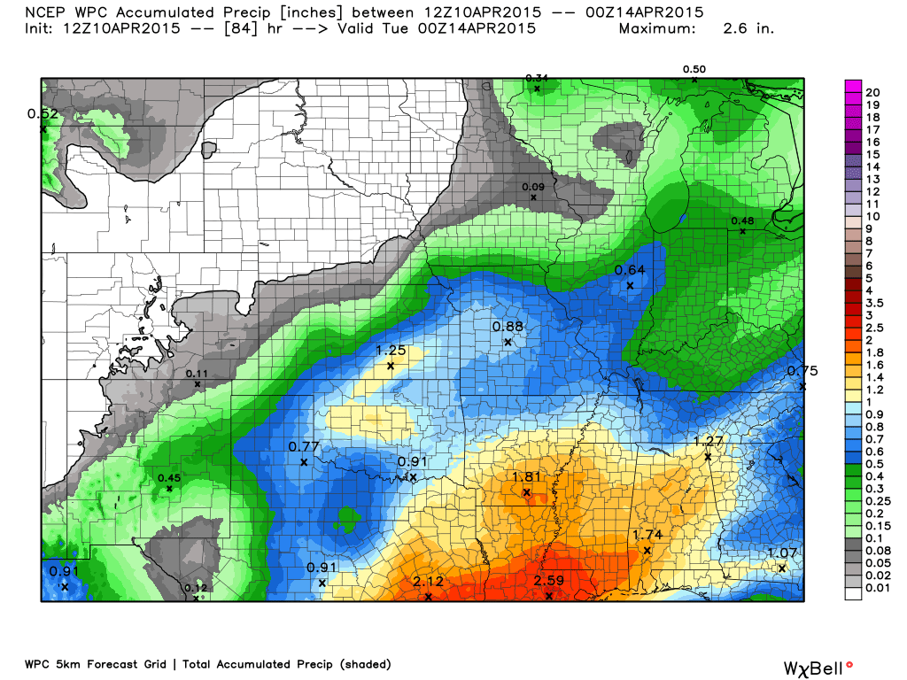
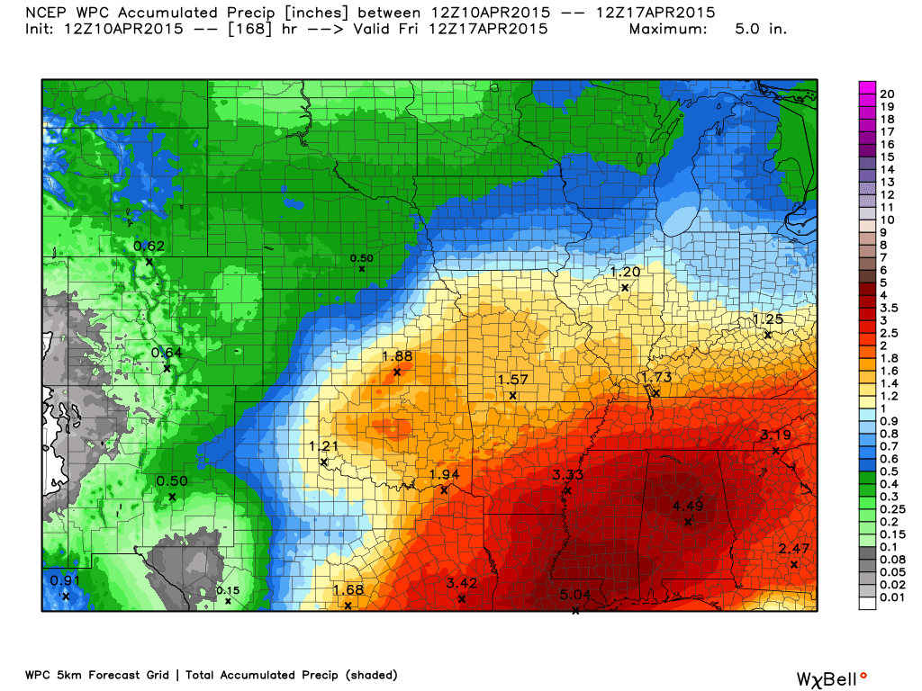
How much precipitation should we expect over the next few days?
Rainfall through 7 pm Monday night
Rainfall through the entire week

This section of the blog is speculative forecast information. Because it is past the range of what meteorologists can forecast accurately, it should be considered speculation. Anything past day 5 is considered a long range forecast.
On and off rain chances will be the rule over the coming 7 days. Perhaps Tuesday will be dry.
More rain chances for Wednesday into Friday. Perhaps a strong storm on Thursday. I will be monitoring. For the most part, however, I suspect we will be dealing with non-severe storms. Some locally heavy downpours possible from time to time.
Longer update tomorrow!

Please visit your local National Weather Service Office by clicking here. The National Weather Service Office, for our region, is located in Paducah, Kentucky. They have a lot of maps and information on their site. Local people…local forecasters who care about our region.


Here is the official 6-10 day and 8-14 day temperature and precipitation outlook. Check the date stamp at the top of each image (so you understand the time frame).
The forecast maps below are issued by the Weather Prediction Center (NOAA).


The latest 8-14 day temperature and precipitation outlook. Note the dates are at the top of the image. These maps DO NOT tell you how high or low temperatures or precipitation will be. They simply give you the probability as to whether temperatures or precipitation will be above or below normal.


Who do you trust for your weather information and who holds them accountable?
I have studied weather in our region since the late 1970’s. I have 37 years of experience in observing our regions weather patterns. My degree is in Broadcast Meteorology from Mississippi State University and an Associate of Science (AS). I am currently working on my Bachelor’s Degree in Geoscience. Just need to finish two Spanish classes!
I am a member of the American Meteorological Society. I am a NOAA Weather-Ready Nation Ambassador. And, I am the Meteorologist for McCracken County Emergency Management.
I own and operate the Southern Illinois Weather Observatory.
There is a lot of noise on the internet. A lot of weather maps are posted without explanation. Over time you should learn who to trust for your weather information.
My forecast philosophy is simple and straight forward.
- Communicate in simple terms
- To be as accurate as possible within a reasonable time frame before an event
- Interact with you on Twitter, Facebook, and the blog
- Minimize the “hype” that you might see on television or through other weather sources
- Push you towards utilizing wall-to-wall LOCAL TV coverage during severe weather events
I am a recipient of the Mark Trail Award, WPSD Six Who Make A Difference Award, Kentucky Colonel, and the Caesar J. Fiamma” Award from the American Red Cross. In 2009 I was presented with the Kentucky Office of Highway Safety Award. I was recognized by the Kentucky House of Representatives for my service to the State of Kentucky leading up to several winter storms and severe weather outbreaks.
If you click on the image below you can read the Kentucky House of Representatives Resolution.

I am also President of the Shadow Angel Foundation which serves portions of western Kentucky and southern Illinois.
Many of my graphics are from www.weatherbell.com – a great resource for weather data, model data, and more


This blog was inspired by ABC 33/40’s Alabama Weather Blog – view their blog
Current tower cam view from the Weather Observatory- Click here for all cameras.

Southern Illinois Weather Observatory

The Weather Observatory

Southern Illinois Weather Observatory
WSIL TV 3 has a number of tower cameras. Click here for their tower camera page & Illinois Road Conditions

Marion, Illinois
WPSD TV 6 has a number of tower cameras. Click here for their tower camera page & Kentucky Road Conditions & Kentucky Highway and Interstate Cameras

Downtown Paducah, Kentucky
Benton, Kentucky Tower Camera – Click here for full view

Benton, Kentucky

I24 Paducah, Kentucky

I24 Mile Point 9 – Paducah, KY

I24 – Mile Point 3 Paducah, Kentucky

You can sign up for my AWARE email by clicking here I typically send out AWARE emails before severe weather, winter storms, or other active weather situations. I do not email watches or warnings. The emails are a basic “heads up” concerning incoming weather conditions.