Monday: A mix of sun and clouds this morning. Western half of the region has mostly clouds. Eastern half has mostly sun.
Clouds will be on the increase today. It will be mild today with highs into the 70’s. Gusty southerly winds, as well.
A cold front will slowly push towards our region over the next 24 to 36 hours. This will increase shower and thunderstorm activity.
Scattered showers and thunderstorms will develop today over southeast Missouri and southern Illinois. Many areas remain dry through this afternoon, but a few showers/storms are expected to develop.
Organized severe weather appears unlikely. A few storms could produce dime size hail and gusty winds. Brief downpours and lightning, of course. Severe weather risk is small.
Rain chances should increase area-wide tonight and on Tuesday.
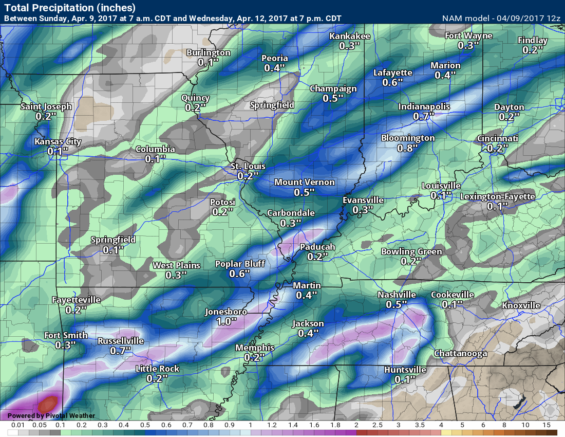
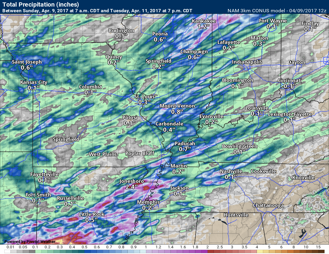
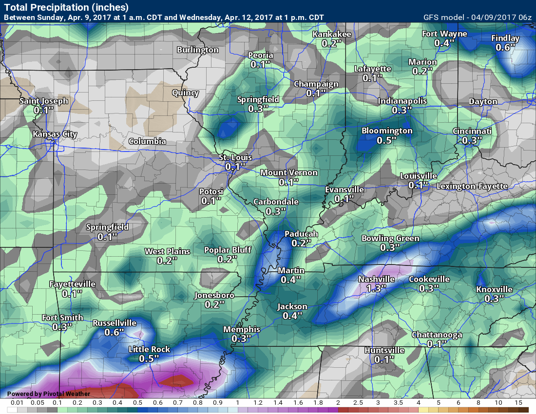
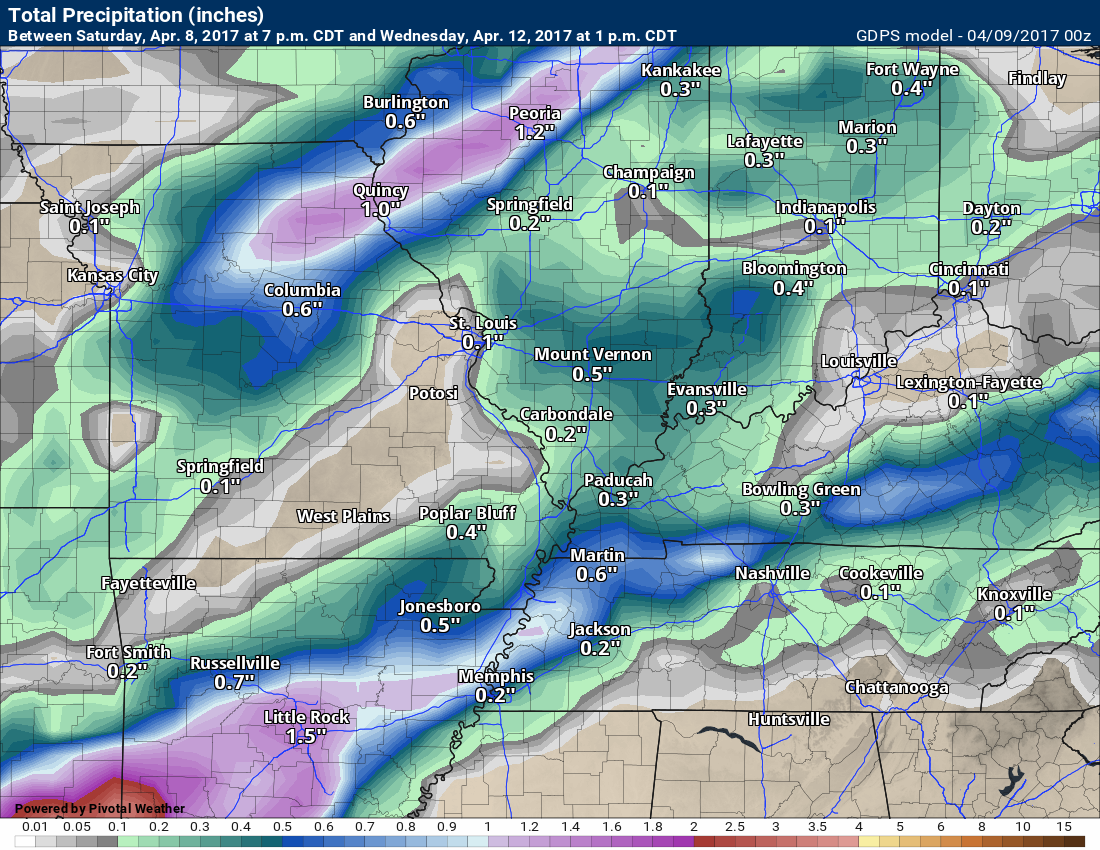
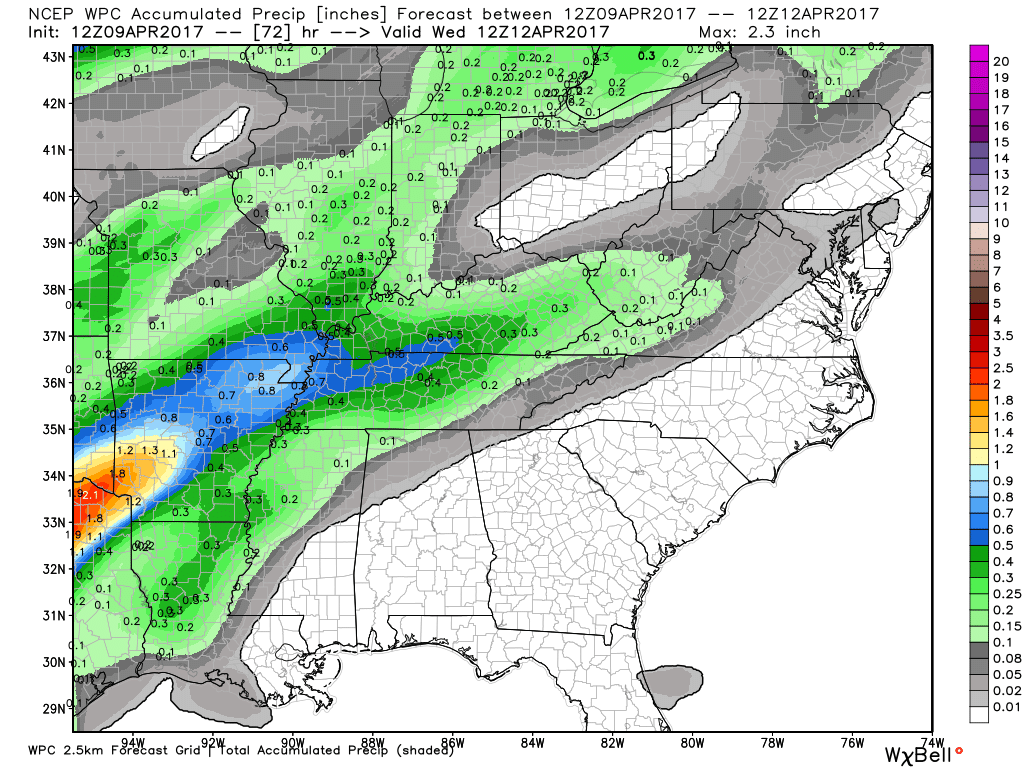
Rainfall totals will vary considerably due to thunderstorms. You can generally expect 0.25″ to 0.50″. If thunderstorms develop or train over the same areas you could double that.
High resolution guidance packages do hint at a band of heavier rain across a few counties of our region, but they don’t agree on placement. Keep that in mind. Thunderstorms would enhance rain totals.
These same high resolution guidance packages also show some spots receiving less than the 0.25″.
Small chance for a remaining shower on Tuesday evening, otherwise, dry weather is expected Tuesday night into Wednesday night.
Another disturbance pushes towards our region on Thursday into the weekend. Guidance is muddled as to the specifics of coverage and rain totals. At least some scattered showers and storms are possible by Thursday.
Temperatures will remain mild into the weekend. No cold shots in the forecast.

This forecast update covers far southern Illinois, far southeast Missouri, and far western Kentucky. See the coverage map on the right side of the blog
.
Interactive Weather Radar Page. Choose the city nearest your location: Click this link
April 9, 2017
Sunday Night Forecast Details:
Forecast: Partly cloudy and mild. Windy.
Temperatures: MO ~ 55 to 60 IL ~ 55 to 60 KY ~ 55 to 60 TN ~ 55 to 60
Winds: South winds at 15 to 35 mph and gusty.
My confidence in the forecast verifying: High. This forecast should verify.
What impacts are anticipated from the weather? Strong and gusty winds. Winds should gust above 30 mph
Is severe weather expected? No.
The NWS defines severe weather as 58 mph winds or great, 1″ hail or larger, and/or tornadoes
What is the chance of precipitation? MO ~ 10% IL ~ 10% KY ~ 0% TN ~ 0%
Coverage of precipitation: Most likely none.
Should I cancel my outdoor plans? No
.
April 10, 2017
Monday Forecast Details
Forecast: A mix of sun and clouds. Mild. A 30% for showers and thunderstorms.
Temperatures: MO ~ 72 to 76 IL ~ 72 to 76 KY ~ 74 to 78 TN ~ 74 to 78
Winds: South winds at 10 to 20 mph and gusty.
What impacts are anticipated from the weather? Most likely none.
My confidence in the forecast verifying: High. This forecast should verify.
Is severe weather expected? Unlikely. Small risk for gusty winds and dime size hail. Monitor updates.
The NWS defines severe weather as 58 mph winds or great, 1″ hail or larger, and/or tornadoes
What is the chance of precipitation? MO ~ 30% IL ~ 30% KY ~ 30% TN ~ 20%
Coverage of precipitation: Isolated to scattered
Should I cancel my outdoor plans? No
Sunrise will be at 6:25 a.m. and sunset will be at 7:25 p.m.
Monday Night Forecast Details:
Forecast: Cloudy. A 60% for showers. Thunderstorms possible.
Temperatures: MO ~ 52 to 56 IL ~ 52 to 56 KY ~ 52 to 56 TN ~ 52 to 56
Winds: South and southwest winds at 7 to 14 mph. Gusts to 15 mph.
My confidence in the forecast verifying: High. This forecast should verify.
What impacts are anticipated from the weather? Wet roadways. Perhaps lightning.
Is severe weather expected? Unlikely, but monitor updates.
The NWS defines severe weather as 58 mph winds or great, 1″ hail or larger, and/or tornadoes
What is the chance of precipitation? MO ~ 60% IL ~ 60% KY ~ 60% TN ~ 60%
Coverage of precipitation: Scattered to perhaps widespread.
Should I cancel my outdoor plans? Should be okay, but monitor radars during the evening. A band of showers may approach from the west.
.
April 11, 2017
Tuesday Forecast Details
Forecast: Partly to mostly cloudy. A 40% for a shower. A thunderstorm possible.
Temperatures: MO ~ 65 to 70 IL ~ 65 to 70 KY ~ 66 to 70 TN ~ 66 to 70
Winds: Winds becoming north and northwest early in the day at speeds of 6 to 12 mph with gusts to 14 mph
What impacts are anticipated from the weather? Perhaps some wet roadways. Possibly lightning.
My confidence in the forecast verifying: Medium. Some adjustments are possible.
Is severe weather expected? No
The NWS defines severe weather as 58 mph winds or great, 1″ hail or larger, and/or tornadoes
What is the chance of precipitation? MO ~ 40% IL ~ 40% KY ~ 50% TN ~ 50%
Coverage of precipitation: Scattered to perhaps numerous for a brief period of time.
Should I cancel my outdoor plans? Have a plan B.
Sunrise will be at 6:23 a.m. and sunset will be at 7:26 p.m.
Tuesday Night Forecast Details:
Forecast: Partly cloudy.
Temperatures: MO ~ 46 to 52 IL ~ 46 to 52 KY ~ 46 to 52 TN ~ 48 to 52
Winds: North and northeast winds at 4 to 8 mph.
My confidence in the forecast verifying: Medium. Some adjustments are possible.
What impacts are anticipated from the weather? Wet roadways.
Is severe weather expected? No
The NWS defines severe weather as 58 mph winds or great, 1″ hail or larger, and/or tornadoes
What is the chance of precipitation? MO ~ 10% IL ~ 10% KY ~ 20% TN ~ 20%
Coverage of precipitation: Rain should come to an end.
Should I cancel my outdoor plans? No.
.
April 12, 2017
Wednesday Forecast Details
Forecast: Mostly sunny. Mild. Nice day anticipated.
Temperatures: MO ~ 72 to 76 IL ~ 72 to 76 KY ~ 72 to 76 TN ~ 72 to 76
Winds: East winds at 5 to 10 mph
What impacts are anticipated from the weather? None.
My confidence in the forecast verifying: Medium. Some adjustments are possible.
Is severe weather expected? No
The NWS defines severe weather as 58 mph winds or great, 1″ hail or larger, and/or tornadoes
What is the chance of precipitation? MO ~ 0% IL ~ 0% KY ~ 0% TN ~ 0%
Coverage of precipitation: None.
Should I cancel my outdoor plans? No.
Sunrise will be at 6:22 a.m. and sunset will be at 7:27 p.m.
Wednesday Night Forecast Details:
Forecast: Mostly clear.
Temperatures: MO ~ 52 to 58 IL ~ 52 to 56 KY ~ 52 to 58 TN ~ 54 to 58
Winds: East and southeast winds at 8 mph.
My confidence in the forecast verifying: Medium. Some adjustments are possible.
What impacts are anticipated from the weather? None.
Is severe weather expected? No
The NWS defines severe weather as 58 mph winds or great, 1″ hail or larger, and/or tornadoes
What is the chance of precipitation? MO ~ 0% IL ~ 0% KY ~ 0% TN ~ 0%
Coverage of precipitation: None
Should I cancel my outdoor plans? No.
.
April 13, 2017
Thursday Forecast Details
Forecast: Partly sunny. A shower or thunderstorm possible.
Temperatures: MO ~ 72 to 76 IL ~ 72 to 76 KY ~ 72 to 76 TN ~ 72 to 76
Winds: South and southwest winds at 5 to 10 mph
What impacts are anticipated from the weather? Perhaps some lightning and wet roadways.
My confidence in the forecast verifying: Medium. Some adjustments are possible.
Is severe weather expected? Monitor updates.
The NWS defines severe weather as 58 mph winds or great, 1″ hail or larger, and/or tornadoes
What is the chance of precipitation? MO ~ 30% IL ~ 30% KY ~ 30% TN ~ 30%
Coverage of precipitation: Scattered.
Should I cancel my outdoor plans? No, but monitor updated forecasts.
Sunrise will be at 6:21 a.m. and sunset will be at 7:28 p.m.
Thursday Night Forecast Details:
Forecast: Partly cloudy. A chance for a shower or thunderstorm.
Temperatures: MO ~ 55 to 60 IL ~ 55 to 60 KY ~ 55 to 60 TN ~ 55 to 60
Winds: South and southwest winds at 8 mph.
My confidence in the forecast verifying: Medium. Some adjustments are possible.
What impacts are anticipated from the weather? Perhaps some lightning and wet roadways.
Is severe weather expected? Monitor updates.
The NWS defines severe weather as 58 mph winds or great, 1″ hail or larger, and/or tornadoes
What is the chance of precipitation? MO ~ 30% IL ~ 30% KY ~ 30% TN ~ 30%
Coverage of precipitation: Scattered
Should I cancel my outdoor plans? No, but monitor updates.

Don’t forget to check out the Southern Illinois Weather Observatory web-site for weather maps, tower cams, scanner feeds, radars, and much more! Click here

An explanation of what is happening in the atmosphere over the coming day

Severe thunderstorm outlook.
Remember that a severe thunderstorm is defined as a thunderstorm that produces 60 mph winds or higher, quarter size hail or larger, and/or a tornado.
Sunday night: Severe weather is not anticipated.
Monday through Tuesday night: Severe weather is not anticipated. A cold front will pass through the area with a few thunderstorms. Lightning is the concern. At this time, severe weather does not appear to be a concern. Monitor updates, as always.
Wednesday and Thursday: Severe weather is not anticipated.
———————————-
Your day by day analysis
Sunday night:
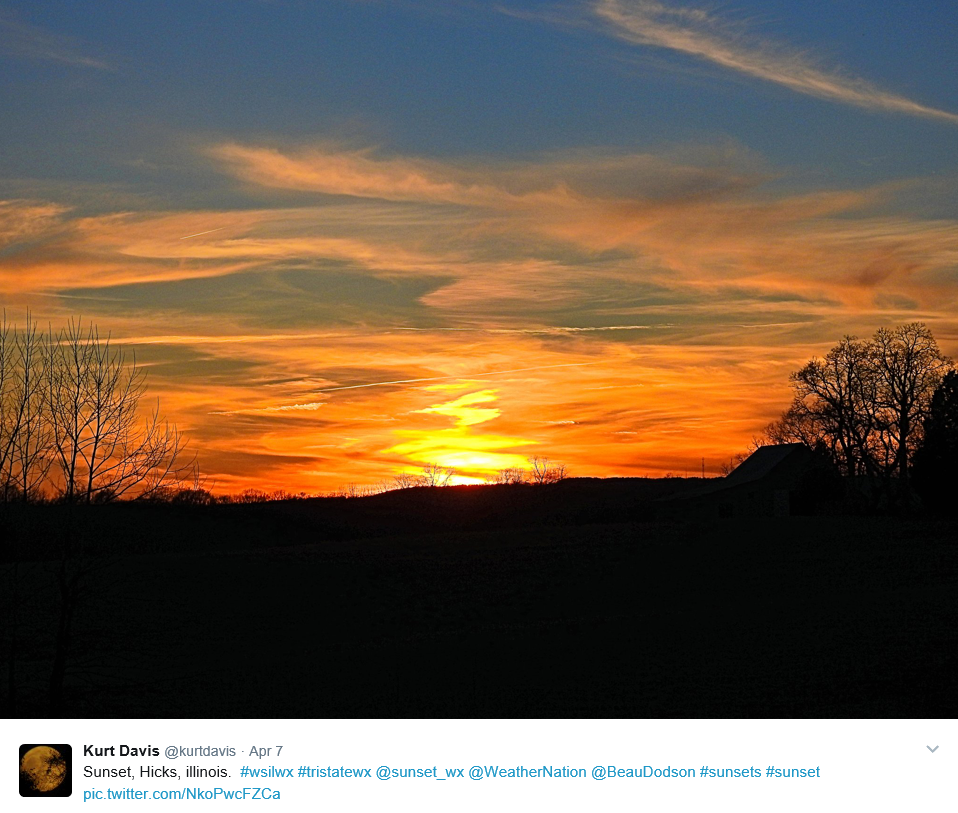
Great photograph sent in from Kurt Davis
Hicks, Illinois.
Thanks, Kurt
Sunday night will deliver some increase in clouds and breezy conditions. Winds will continue to gust above 35 mph. Mild temperatures, as well.
A couple of showers might develop after 3 am. It appears the bulk of our rain chances will hold off until Monday evening into Tuesday evening.
Monday into Tuesday night:
Rain?
Guidance continues to show little agreement on our Monday and Tuesday system.
Monday will start out partly cloudy. Clouds will increase through the day. Rain chances will increase during the afternoon hours. Scattered showers and storms could develop over southeast Missouri and southern Illinois.
Rain chances will increase a bit by Monday night into Tuesday. This will occur as a cold front moves into the region.
Rain chances on Monday night/Tuesday morning will range from 50% to 60%. Thunder is possible, but severe weather is not anticipated.
It is possible that some areas receive very little rainfall from this event. Guidance has been trending downward with rain totals.
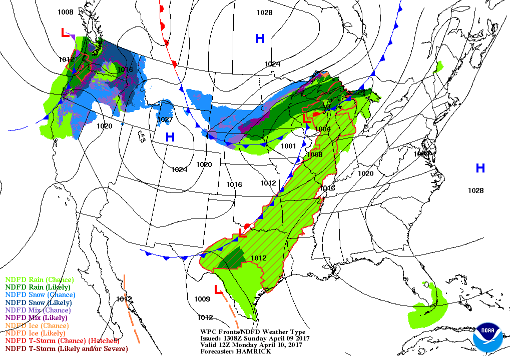
Let’s take a look at the cold front on the weather map
You can see the progression. This first map is for 7 am on Monday. Front is still over western Missouri. The front will slowly move east. Green represents rain.
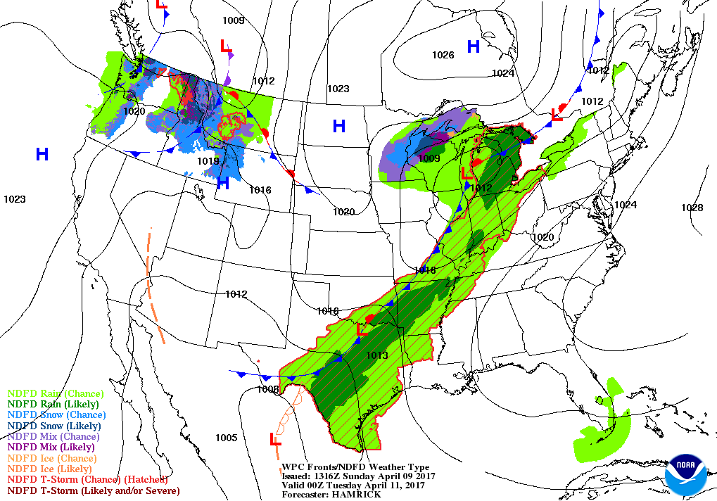
This next image is for 7 pm on Monday
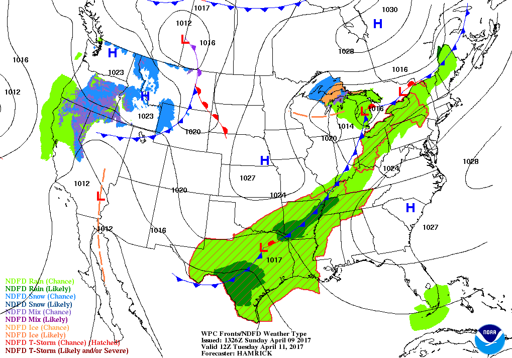
This next image is for 7 am on Tuesday
It has been a bit of a headache to figure out how much rain this system will produce. We are moving into the time of year where thunderstorms can skew rainfall totals.
Generally, I am anticipating 0.25″ to 0.50″. There has been a slow downward trend in rainfall totals with each passing day.
If thunderstorms develop them pockets of greater than 0.50″ will certainly be a possibility.
The guidance has been showing a band of heavier rain somewhere in our region. The placement of that heavier band has been in question. Each day the guidance shows this band.
If heavier totals occur it will probably be because of thunderstorms.
Here is the NAM guidance rainfall totals forecast
Here is the high resolution NAM model
Here is the GFS model
And here is the GEM guidance. Each a bit different.
Here is the official WPC/NOAA rainfall forecast
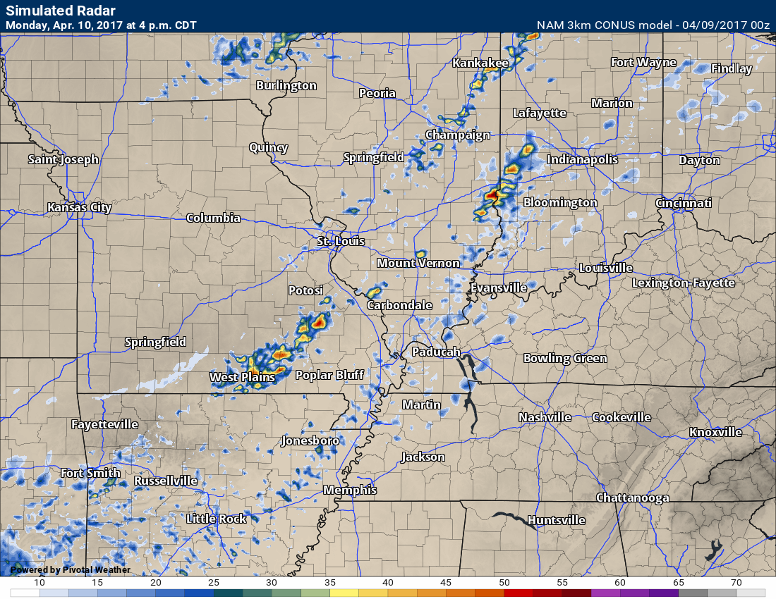
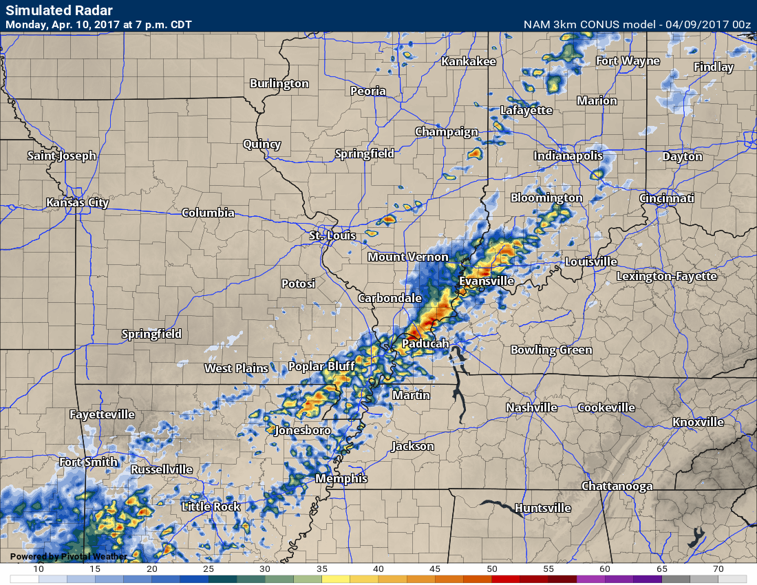
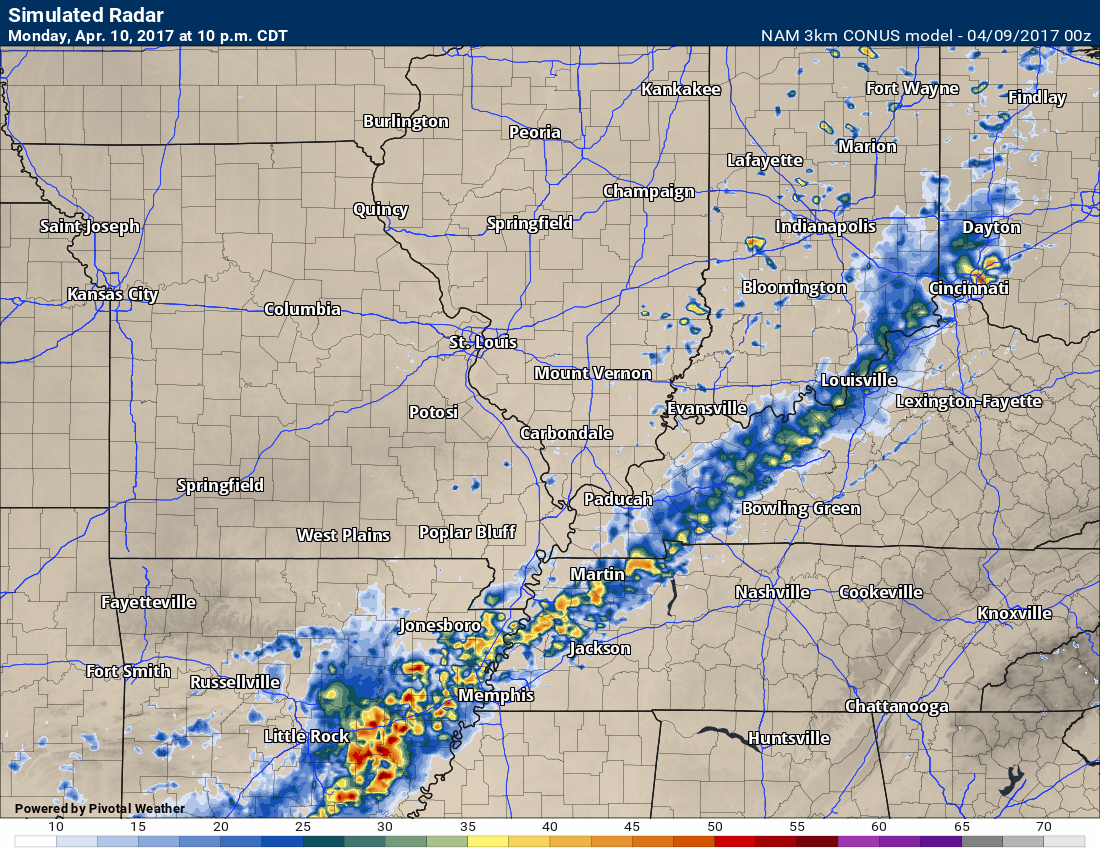
Let’s take a look at future-cast radar, as well.
This is what one model believes will happen
The high res NAM and normal NAM guidance shows this system in and out of here fairly fast. GFS guidance is slower.
4 PM Monday
7 PM Monday
10 PM Monday
There remains some question on precipitation coverage on Tuesday and Tuesday evening.
Rain should come to an end on Tuesday.
Wednesday and Thursday should be dry. Temperatures will be mild into the weekend. You can expect 70’s on Wednesday, Thursday, Friday, and Saturday! I think we can handle that. Spring is underway.
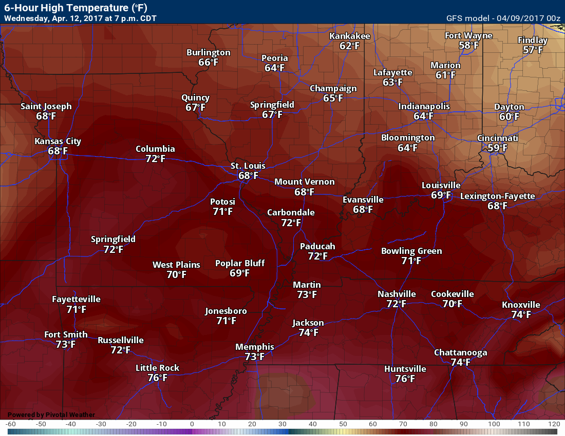
Check out these temperature maps! Wednesday through next Sunday. Any complaints?
Wednesday 7 PM temperatures
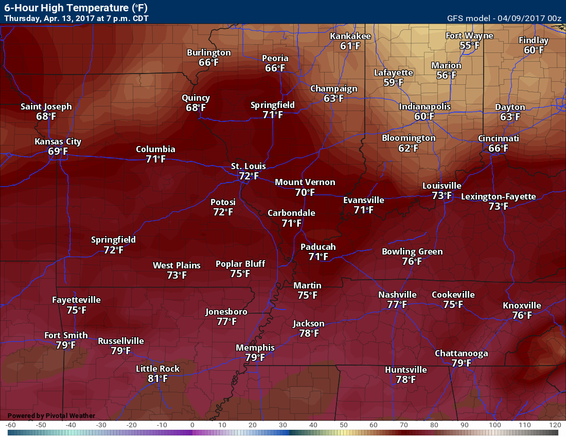
Thursday (image below)
7 PM temperatures
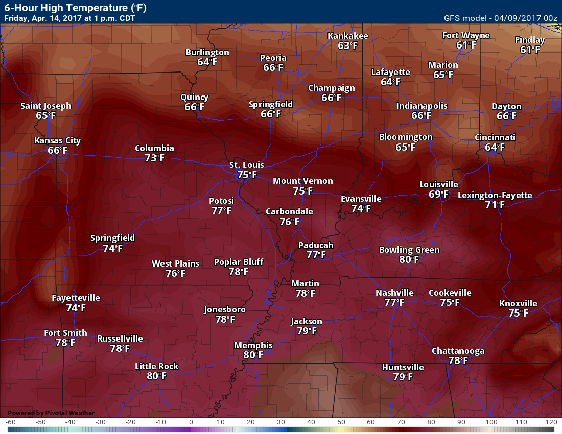
Friday (image below)
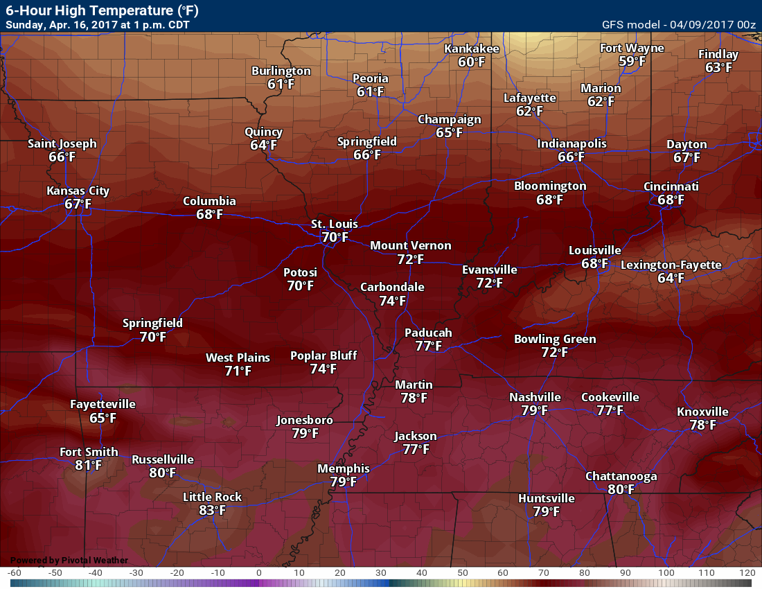
1 PM temperatures
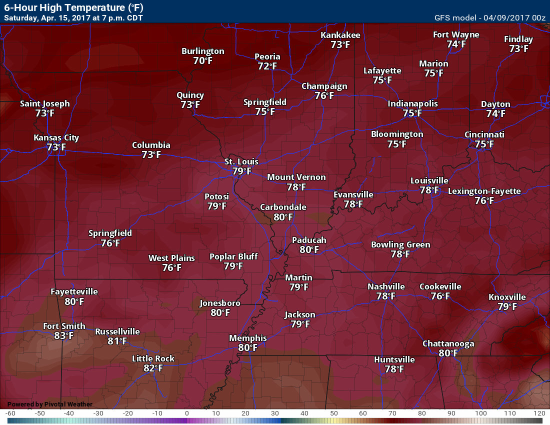
Saturday (image below)
7 pm temperatures
Sunday (below)
1 pm temperatures
Find me on Twitter

We have regional radars and local city radars – if a radar does not update then try another one. Occasional browsers need their cache cleared. You may also try restarting your browser. That usually fixes the problem. Occasionally we do have a radar go down. That is why I have duplicates. Thus, if one fails then try another one.
During the winter you can track snow and ice by clicking the winterize button on the local city view interactive radars.
If you have any problems then please send me an email beaudodson@usawx.com
Interactive Weather Radar Page. Choose the city nearest your location: Click this link—
National interactive radar: Click this link.
Local interactive city radars include St Louis, Mt Vernon, Evansville, Poplar Bluff, Cape Girardeau, Marion, Paducah, Hopkinsville, Memphis, Nashville, Dyersburg, and all of eastern Kentucky. These are interactive radars. Local city radars – click here
Regional Radar


The official 6-10 day and 8-14 day temperature and precipitation outlook. Check the date stamp at the top of each image (so you understand the time frame).
The forecast maps below are issued by the Weather Prediction Center (NOAA)


The latest 8-14 day temperature and precipitation outlook. Note the dates are at the top of the image. These maps DO NOT tell you how high or low temperatures or precipitation will be. They simply give you the probability as to whether temperatures or precipitation will be above or below normal.


The Beau Dodson Weather APP is ready for Apple and Android users. The purpose of this app is for me to deliver your text messages instantly. ATT and Verizon have not always been reliable when it comes to speed. The app allows instant delivery.
Some of you have asked if you can keep receiving the texts on your phone and the app. The answer to that is, yes. The Android app will automatically allow that to happen. On the Apple app, however, you will need to go into your app and click settings. Make sure the green tab is OFF. Off means you will still receive the texts to your phone and the app. If you have any questions, then email me at beaudodson@usawx.com
The app is for text subscribers.
The direct download, for the Apple app, can be viewed here
https://itunes.apple.com/us/app/id1190136514
If you have not signed up for the texting service then you may do so at www.beaudodsonweather.com

The Android app is also ready.
Remember, the app’s are for www.weathertalk.com subscribers. The app allows your to receive the text messages faster than ATT and Verizon.
Here is the download link for the Android version Click Here

——————————————————–
If you have not signed up for the texts messages, then please do. Link www.beaudodsonweather.com
Your support helps with the following:

and


Who do you trust for your weather information and who holds them accountable?
I have studied weather in our region since the late 1970’s. I have 39 years of experience in observing our regions weather patterns. My degree is in Broadcast Meteorology and a Bachelor’s of Science.
My resume includes:
Member of the American Meteorological Society.
NOAA Weather-Ready Nation Ambassador.
Meteorologist for McCracken County Emergency Management. I served from 2005 through 2015.
Meteorologist for McCracken County Rescue. 2015 through current
I own and operate the Southern Illinois Weather Observatory.
I am the chief meteorologist for Weather Talk LLC. I am the owner of Weather Talk LLC.
I am also a business owner in western Kentucky.
Recipient of the Mark Trail Award, WPSD Six Who Make A Difference Award, Kentucky Colonel, and the Caesar J. Fiamma” Award from the American Red Cross.
In 2005 I helped open the largest American Cross shelter in U.S. history in Houston, Texas. I was deployed to help after Hurricane Katrina and Hurricane Rita. I was a shelter manager of one of the Houston, Texas shelter divisions.
In 2009 I was presented with the Kentucky Office of Highway Safety Award.
Recognized by the Kentucky House of Representatives for my service to the State of Kentucky leading up to several winter storms and severe weather outbreaks.
If you click on the image below you can read the Kentucky House of Representatives Resolution.

I am also President of the Shadow Angel Foundation which serves portions of western Kentucky and southern Illinois.
There is a lot of noise on the internet. A lot of weather maps are posted without explanation. Over time you should learn who to trust for your weather information.
My forecast philosophy is simple and straight forward.
- Communicate in simple terms
- To be as accurate as possible within a reasonable time frame before an event
- Interact with you on Twitter, Facebook, email, texts, and this blog
- Minimize the “hype” that you might see on some television stations or through other weather sources
- Push you towards utilizing wall-to-wall LOCAL TV coverage during severe weather events
Many of the graphics on this page are from www.weatherbell.com
WeatherBell is a great resource for weather model guidance.


You can sign up for my AWARE email by clicking here I typically send out AWARE emails before severe weather, winter storms, or other active weather situations. I do not email watches or warnings. The emails are a basic “heads up” concerning incoming weather conditions