April 2, 2018
Monday Forecast Details
Forecast: A mix of sun and clouds. Milder. A chance for scattered showers and thunderstorms.
Temperatures: MO ~ 48 to 54 IL ~ 46 to 55 KY ~ 53 to 56 TN ~ 54 to 58
What is the chance of precipitation? MO ~ 40% IL ~ 40% KY ~ 40% TN ~ 40%
Coverage of precipitation: Scattered
Winds: Northeast to east becoming east and southeast at 5 to 10 mph with gusts to 14 mph
What impacts are anticipated from the weather? Wet roadways. Lightning.
My confidence in the forecast verifying: High
Is severe weather expected? No
The NWS defines severe weather as 58 mph wind or great, 1″ hail or larger, and/or tornadoes
Should I cancel my outdoor plans? No, but check radars
Sunrise 6:38 AM
Monday Night Forecast Details:
Forecast: Mostly cloudy. Temperatures holding steady. Showers and thunderstorms again possible. Not as cold.
Temperatures: MO ~ 48 to 54 IL ~ 48 to 54 KY ~ 50 to 55 TN ~ 50 to 55
What is the chance of precipitation? MO ~ 50% IL ~ 60% KY ~ 40% TN ~ 30%
Coverage of precipitation: Scattered.
Winds: South at 6 to 12 mph with gusts to 20
What impacts are anticipated from the weather? Wet roadways. Lightning. Hail possible northern half of southern Illinois. This will depend on the placement of the warm front.
My confidence in the forecast verifying: High
Is severe weather expected? Monitor updates. A few strong storms possible Monday night over the northern half of southern Illinois.
The NWS defines severe weather as 58 mph wind or great, 1″ hail or larger, and/or tornadoes
Should I cancel my outdoor plans? No, but monitor radars.
Sunset 7:17 PM
April 3, 2018
Tuesday Forecast Details
Forecast: Wind alert. Strong and gusty winds. Mostly cloudy. A few breaks in the clouds. Increasing chances of thunderstorms. Some thunderstorms could become severe. Monitor updates. There remain some questions on the timing of the cold front. This will be key to the threat of severe thunderstorms. The risk increases if the front moves through the area during the afternoon and evening.
Temperatures: MO ~ 65 to 70 IL ~ 65 to 70 KY ~ 68 to 74 TN ~ 68 to 74
What is the chance of precipitation? MO ~ 70% IL ~ 70% KY ~ 70% TN ~ 70%
Coverage of precipitation: Becoming widespread.
Winds: South 15 to 30 mph with gusts to 40 mph
What impacts are anticipated from the weather? Wet roadways. High winds. Severe thunderstorms are possible with hail, damaging winds, and isolated tornadoes.
My confidence in the forecast verifying: Medium
Is severe weather expected? Yes. Severe storms are possible.
The NWS defines severe weather as 58 mph wind or great, 1″ hail or larger, and/or tornadoes
Should I cancel my outdoor plans? Have a plan B. Monitor radars. Monitor updates.
Sunrise 6:37 AM
Tuesday Night Forecast Details:
Forecast: A chance of thunderstorms early. Some of the storms could be severe. Again, the timing of the cold front will be key to when storms move through your area. Turning sharply colder.
Temperatures: MO ~ 29 to 34 IL ~ 28 to 34 KY ~ 30 to 35 TN ~ 30 to 35
What is the chance of precipitation? MO ~ 60% IL ~ 60% KY ~ 60% TN ~ 60%
Coverage of precipitation: Scattered to widespread, but ending from west to east.
Winds: South becoming northwest at 10 to 20 mph with gusts to 30 mph
What impacts are anticipated from the weather? Wet roadways. Lightning. I can’t rule out severe weather early in the evening. This will depend on the timing of the cold front. I will monitor the risk of freezing temperatures, as well. No snow or ice anticipated. Sensitive vegetation could have problems with the cold temperatures. Winds will prevent frost from forming.
My confidence in the forecast verifying: Medium
Is severe weather expected? Monitor updates. A few strong storms possible Monday night and Tuesday.
The NWS defines severe weather as 58 mph wind or great, 1″ hail or larger, and/or tornadoes
Should I cancel my outdoor plans? Have a plan B. Monitor updates and radars.
Sunset 7:18 PM
April 4, 2018
Wednesday Forecast Details
Forecast: Partly sunny. Cooler.
Temperatures: MO ~ 46 to 52 IL ~ 46 to 52 KY ~ 48 to 54 TN ~ 50 to 52
What is the chance of precipitation? MO ~ 0% IL ~ 0% KY ~ 0% TN ~ 0%
Coverage of precipitation: None
Winds: North and northwest at 10 to 20 mph
What impacts are anticipated from the weather? None
My confidence in the forecast verifying: High
Is severe weather expected? No
The NWS defines severe weather as 58 mph wind or great, 1″ hail or larger, and/or tornadoes
Should I cancel my outdoor plans? No
Sunrise: 6:35 AM
Wednesday Night Forecast Details:
Forecast: Cold. Frost or freeze possible. Mostly clear.
Temperatures: MO ~ 28 to 32 IL ~ 28 to 32 KY ~ 28 to 32 TN ~ 28 to 34
What is the chance of precipitation? MO ~ 0% IL ~ 0% KY ~ 0% TN ~ 0%
Coverage of precipitation: None
Winds: Northwest at 4 to 8 mph
What impacts are anticipated from the weather? Frost and/or freeze possible
My confidence in the forecast verifying: High
Is severe weather expected? Monitor updates. A few strong storms possible Monday night and Tuesday.
The NWS defines severe weather as 58 mph wind or great, 1″ hail or larger, and/or tornadoes
Should I cancel my outdoor plans? No
Sunset: 7:19
April 5, 2018
Thursday Forecast Details
Forecast: Mostly sunny. A few passing clouds.
Temperatures: MO ~ 55 to 60 IL ~ 55 to 60 KY ~ 55 to 60 TN ~ 56 to 62
What is the chance of precipitation? MO ~ 0% IL ~ 0% KY ~ 0% TN ~ 0%
Coverage of precipitation: None
Winds: South and southwest at 7 to 14 mph and gusty
What impacts are anticipated from the weather? None
My confidence in the forecast verifying: Medium
Is severe weather expected? No
The NWS defines severe weather as 58 mph wind or great, 1″ hail or larger, and/or tornadoes
Should I cancel my outdoor plans? No
Sunrise: 6:34 AM
Thursday Night Forecast Details:
Forecast: Increasing clouds. A chance of showers. A thunderstorm possible.
Temperatures: MO ~ 35 to 40 IL ~ 35 to 40 KY ~ 35 to 40 TN ~ 36 to 42
What is the chance of precipitation? MO ~ 30% IL ~ 30% KY ~ 30% TN ~ 30%
Coverage of precipitation: Scattered
Winds: South and southwest at 6 to 12 mph
What impacts are anticipated from the weather? Wet roadways. Lightning.
My confidence in the forecast verifying: Medium
Is severe weather expected? No
The NWS defines severe weather as 58 mph wind or great, 1″ hail or larger, and/or tornadoes
Should I cancel my outdoor plans? Monitor updates. Most likely you will be okay.
Sunset: 7:20 PM
April 6, 2018
Friday Forecast Details
Forecast: Cloudy. Rain and thunderstorms developing. Breezy. Some guidance shows snow across portions of the region. Monitor updates.
Temperatures: MO ~ 45 to 50 IL ~ 45 to 50 KY ~ 46 to 52 TN ~ 48 to 54
What is the chance of precipitation? MO ~ 60% IL ~ 60% KY ~ 60% TN ~ 60%
Coverage of precipitation: Becoming widespread
Winds: Variable at 10 to 20 mph and gusty
What impacts are anticipated from the weather? Wet roadways. Lightning. Monitor wintry precip updates.
My confidence in the forecast verifying: LOW
Is severe weather expected? Monitor updates
The NWS defines severe weather as 58 mph wind or great, 1″ hail or larger, and/or tornadoes
Should I cancel my outdoor plans? Have a plan B and monitor updates.
Sunrise: 6:32 AM
Friday Night Forecast Details:
Forecast: Cloudy with showers and thunderstorms. Wintry precipitation possible.
Temperatures: MO ~ 28 to 34 IL ~ 28 to 34 KY ~ 30 to 35 TN ~ 30 to 35
What is the chance of precipitation? MO ~ 60% IL ~ 60% KY ~ 60% TN ~ 60%
Coverage of precipitation: Perhaps widespread
Winds: Becoming west and northwest at 10 to 20 mph and gusty
What impacts are anticipated from the weather? Wet roadways. Lightning. Monitor wintry precipitation forecast.
My confidence in the forecast verifying: LOW
Is severe weather expected? Monitor updates.
The NWS defines severe weather as 58 mph wind or great, 1″ hail or larger, and/or tornadoes
Should I cancel my outdoor plans? Have a plan B
Sunset: 7:21 PM
April 7, 2018
Saturday Forecast Details
Forecast: Partly sunny. Cool. Morning showers or snow showers ending.
Temperatures: MO ~ 48 to 54 IL ~ 48 to 54 KY ~ 50 to 55 TN ~ 50 to 55
What is the chance of precipitation? MO ~ 20% IL ~ 20% KY ~ 20% TN ~ 20%
Coverage of precipitation: Most likely ending.
Winds: North at 10 to 20 mph and gusty
What impacts are anticipated from the weather? Wet roadways.
My confidence in the forecast verifying: Medium
Is severe weather expected? No
The NWS defines severe weather as 58 mph wind or great, 1″ hail or larger, and/or tornadoes
Should I cancel my outdoor plans? No, but monitor updates
Sunrise: 6:31 AM
Saturday Night Forecast Details:
Forecast: Mostly clear. Colder. Frost or freeze possible.
Temperatures: MO ~ 28 to 34 IL ~ 28 to 34 KY ~ 30 to 34 TN ~ 30 to 34
What is the chance of precipitation? MO ~ 0% IL ~ 0% KY ~ 0% TN ~ 0%
Coverage of precipitation: None
Winds: North northeast at 6 to 12 mph
What impacts are anticipated from the weather? Frost or freeze possible
My confidence in the forecast verifying: Medium
Is severe weather expected? No
The NWS defines severe weather as 58 mph wind or great, 1″ hail or larger, and/or tornadoes
Should I cancel my outdoor plans? No
Sunset: 7:22 PM
April 8, 2018
Sunday Forecast Details
Forecast: Mostly sunny.
Temperatures: MO ~ 54 to 58 IL ~ 52 to 56 KY ~ 55 to 60 TN ~ 56 to 62
What is the chance of precipitation? MO ~ 0% IL ~ 0% KY ~ 0% TN ~ 0%
Coverage of precipitation: None
Winds: North and northeast at 5 to 10 mph
What impacts are anticipated from the weather? None
My confidence in the forecast verifying: Medium
Is severe weather expected? No
The NWS defines severe weather as 58 mph wind or great, 1″ hail or larger, and/or tornadoes
Should I cancel my outdoor plans? No
Sunrise: 6:29 AM
Sunday Night Forecast Details:
Forecast: Mostly clear.
Temperatures: MO ~ 40 to 45 IL ~ 40 to 45 KY ~ 40 to 45 TN ~ 40 to 45
What is the chance of precipitation? MO ~ 0% IL ~ 0% KY ~ 0% TN ~ 0%
Coverage of precipitation: None
Winds: North and northeast at 5 to 10 mph
What impacts are anticipated from the weather? None
My confidence in the forecast verifying: Medium
Is severe weather expected? No
The NWS defines severe weather as 58 mph wind or great, 1″ hail or larger, and/or tornadoes
Should I cancel my outdoor plans? No
Sunset: 7:23 PM
April 1, 2018
First, I can assure you nothing in this forecast is an April Fools joke. It may seem like nature is playing a joke on us. I won’t argue with that.
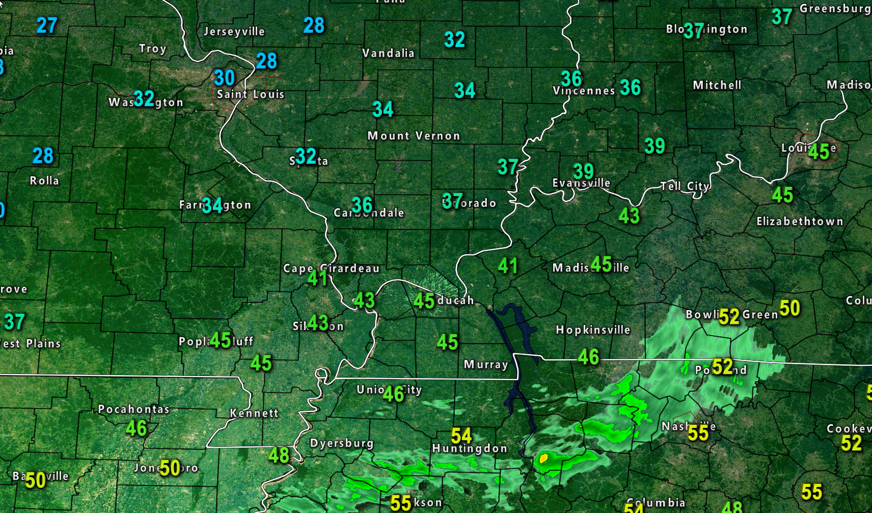
This morning’s temperature map is cold.
1. Cold today. Rain develops late this afternoon (mostly after 3 or 4 PM).
2. Rain tonight. Snow and wintry mix possible northern counties of southeast Missouri and northern counties in southern Illinois.
3. Severe storms are in the forecast Tuesday afternoon and night.
4. Freeze conditions Wednesday night.
5. Another rain and possibly snow event Friday/Saturday.
Happy Easter, everyone. Try to stay warm out there. The Easter bunny has delivered a sharp cold shot of air.
I will be with family today. This may be the only update until later this evening.
I will post some storm/rain/wintry precipitation links below.
It will be cold today with highs only in the 30’s and 40’s.
There is some patchy sunshine across parts of the area this morning. That will be replaced with thickening clouds this afternoon.
Widespread showers and some thunderstorms will develop late this afternoon and evening. The bulk of the rain will hold off until after 3 or 4 PM.
The precipitation may change to a wintry mix or snow from areas along and north of a line from Perry County, Missouri, and then towards Marion, Illinois, and then towards Carmi, Illinois.
The exact placement of the rain/snow line is far from certain and that portion of the forecast is shrouded in low confidence.
I can’t rule out some slushy accumulation on grassy areas, but the heaviest snow may remain just north of my forecast counties.
Either way, widespread precipitation develops this afternoon (late mainly) and tonight.
A few scattered showers possible Monday. Maybe a rumble of thunder.
A few showers and storms possible Monday night.
Severe thunderstorms are possible Tuesday afternoon and evening. Damaging wind and hail possible. I will monitor the tornado risk. Low, for now.
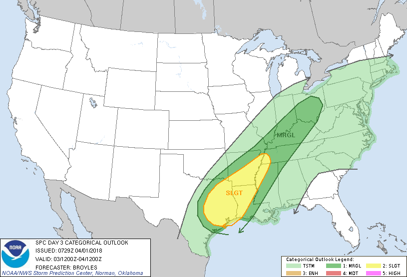
The Storm Prediction Center has already outlined our region in a level 1 out of 5 risk. That is marginal. That is the lowest risk of severe weather. The light green would be sub-severe storms. The dark green is marginal. The yellow is a level 2 out of 5 risk or a slight risk (as they call it).
Colder air arrives again Tuesday night into Wednesday night.
Lows Tuesday night will dip into the 30’s. Lows Wednesday night will dip into the 20’s and 30’s. Freeze/frost conditions are likely.
I am monitoring another precipitation maker Friday and Friday night/Saturday morning. The rain and snow line is questionable this far out.
Many guidance packages are showing snow in or near our region. Not all, but some.
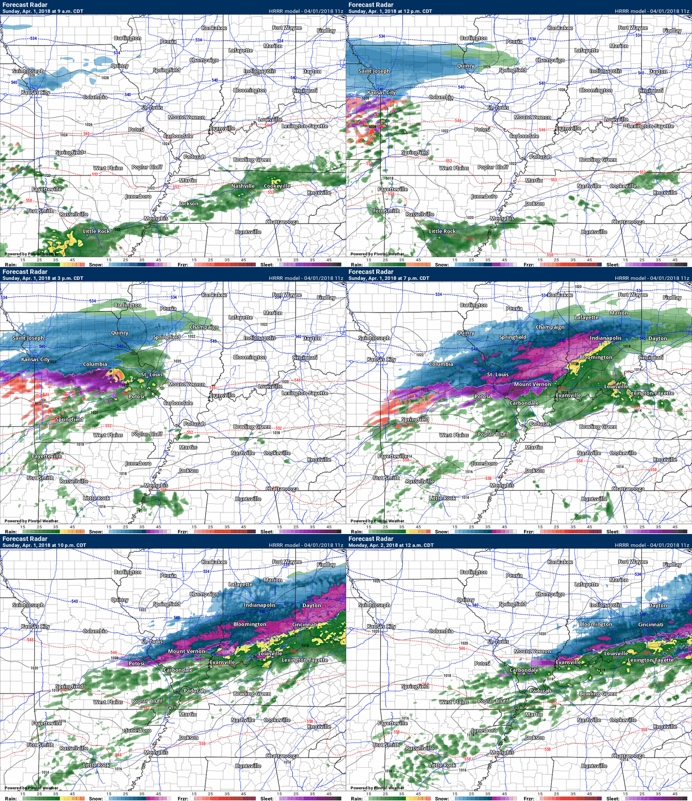
Here is the future-cast radar from the Hrrr model guidance. This is what radar might look like today and tonight.
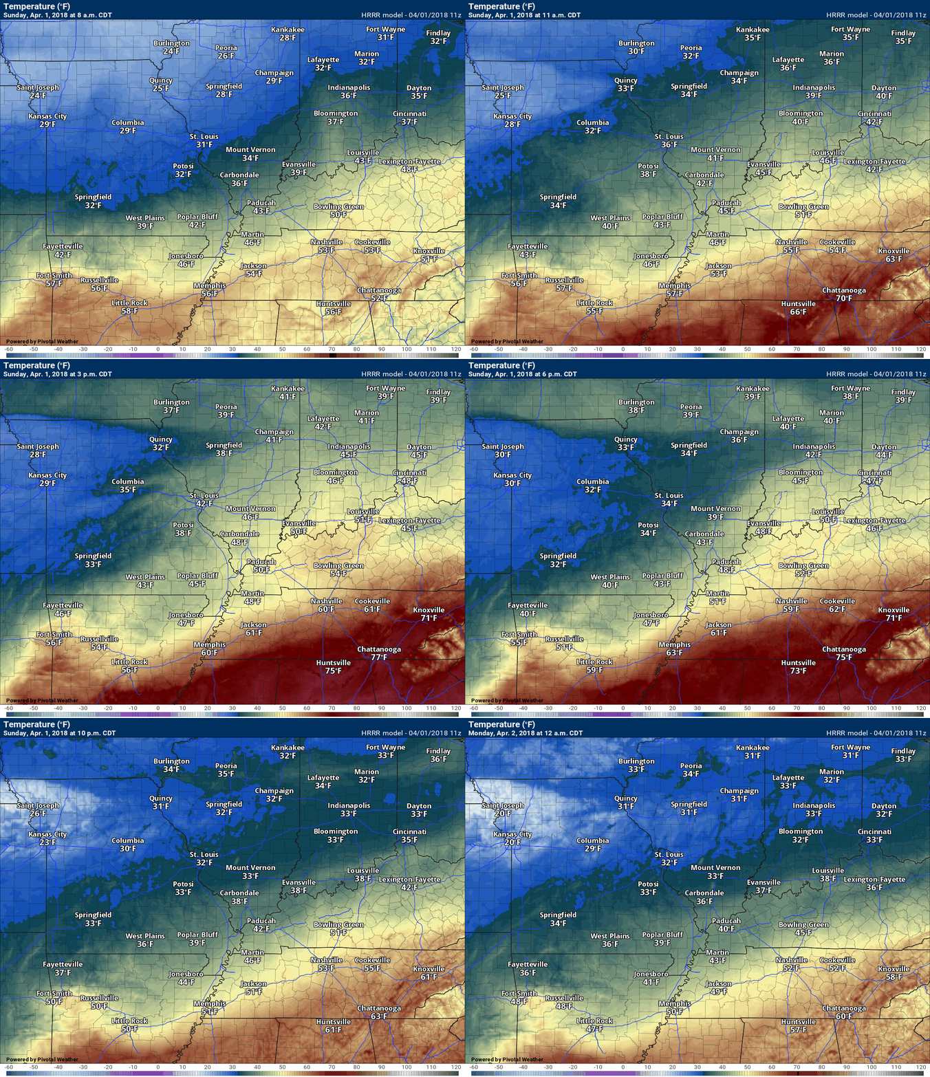
Here is the future-cast temperatures. This will take us into tonight. Chilly.
Links
Radars (don’t forget the local city-view radars have a winterize button on them). Click that and you can see where the rain, snow, and sleet line is situated (it is based off an algorithm, so sometimes it is not perfect).
http://weatherobservatory.com/weather-radar.htm
Lightning map

Interactive Radars:
Interactive live weather radar page. Choose the city nearest your location. If one of the cities does not work then try a nearby one. Click here.

Questions? Broken links? Other?
You may email me at beaudodson@usawx.com
The National Weather Service defines a severe thunderstorm as one that produces quarter size hail or larger, 58 mph winds or greater, and/or a tornado.
Friday through Tuesday:
Severe weather is not anticipated. Lightning is possible Monday into Tuesday. Strong storms possible Monday night/Tuesday.
I am monitoring the risk of severe weather Tuesday.
![]()
Interactive live weather radar page. Choose the city nearest your location. If one of the cities does not work then try a nearby one. Click here.
National map of weather watches and warnings. Click here.
Storm Prediction Center. Click here.
Weather Prediction Center. Click here.

Live lightning data: Click here.

Interactive GOES R satellite. Track clouds. Click here.

Here are the latest local river stage forecast numbers Click Here.
Here are the latest lake stage forecast numbers for Kentucky Lake and Lake Barkley Click Here.

The spring and preliminary summer outlooks have been posted for subscribers. Scroll down to see the outlook.
Not a subscriber? Learn more at this link.


