.
Click one of the links below to take you directly to that section
![]()
![]()
![]()
![]()
![]()
![]()
![]()
Do you have any suggestions or comments? Email me at beaudodson@usawx.com
.
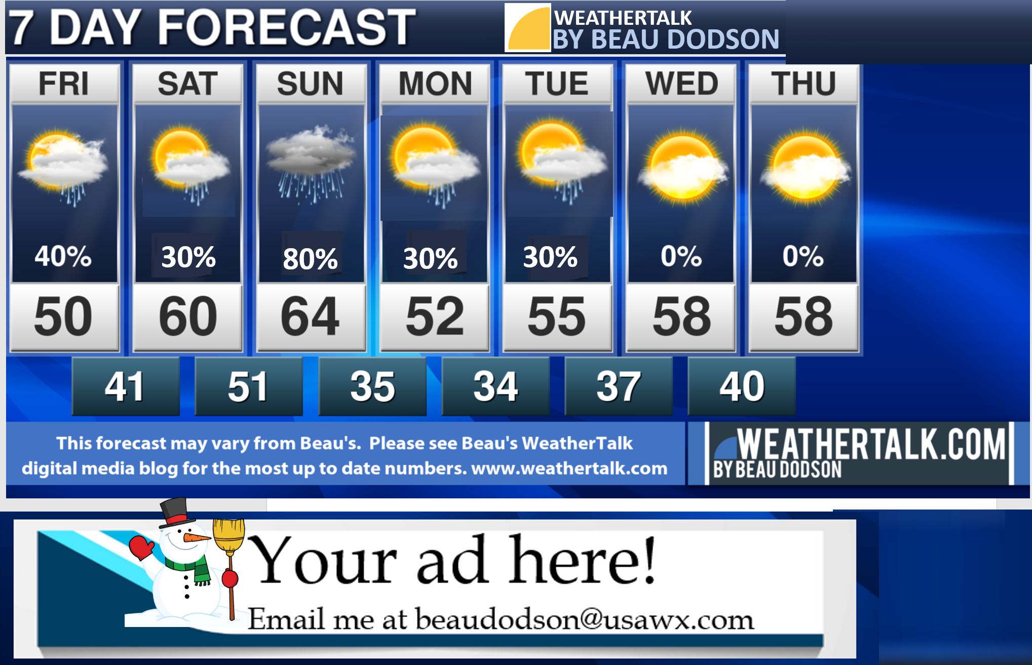
7-day forecast for southeast Missouri, southern Illinois, western Kentucky, and western Tennessee.
This is a BLEND for the region. See the detailed region by region forecast further down in this post.
Rain chances will vary greatly from north to south over the coming days.
See the daily details further down in the blog. See the future-cast radars, as well.
I posted some graphics in the main portion of the weather discussion blog. They will show you a graphical view of the probability chances of rain.
.


.
.

.
Friday to Friday
1. Are accumulating snow or ice in the forecast? No.
2. Is lightning in the forecast? Monitor. I am watching Saturday night into Sunday. Lightning is possible.
3. Are severe thunderstorms in the forecast? No.
* The NWS officially defines a severe thunderstorm as a storm with 58 mph wind or greater, 1″ hail or larger, and/or tornadoes
4. Is flash flooding in the forecast? Monitor. Heavy rain is likely Saturday night. The placement of the heavy rain is still in question. Most models show near the Ohio River and then southward. Avoid flooded roadways.
6. Will the wind chill dip below 10 degrees above zero? No.
.
..

.
February 26, 2021
How confident am I that this days forecast will verify? High Confidence
Friday Forecast: Intervals of clouds. A chance of mainly rain showers across the Missouri Bootheel and then along the Kentucky/Tennessee State line. Rain chances decrease as you move further north. See graphics and the future-cast radars.
What is the chance of precipitation? SE MO ~ 10% north and 30% Bootheel IL ~ 20% KY ~ 0% TN ~ 50%
Temperature range: MO Bootheel 50° to 52° SE MO 48° to 50° South IL 46° to 50° Northwest KY (near Indiana border) 46° to 48° West KY 48° to 52° NW TN 50° to 54°
Wind direction and speed: South becoming west southward at 7 to 14 mph
Wind chill or heat index (feels like) temperature forecast: 45° to 50°
Coverage of precipitation: Numerous far south to none far north
What impacts are anticipated from the weather? Wet roadways.
Should I cancel my outdoor plans? No, but check radars
UV Index: 3. Medium.
Sunrise: 6:30 AM
Sunset: 5:47 PM
.
Friday night Forecast: Patchy fog. Cloudy. Scattered rain showers. Low temperatures will occur early in the night. Rising temperatures overnight.
What is the chance of precipitation? SE MO ~ 30% IL ~ 30% KY ~ 40% along the OH River and 50% further south TN ~ 50%
Temperature range: MO Bootheel 40° to 44° SE MO 35° to 40° South IL 35° to 40° Northwest KY (near Indiana border) 35° to 40° West KY 35° to 40° NW TN 38° to 42°
Wind direction and speed: Southeast at 4 to 8 mph
Wind chill or heat index (feels like) temperature forecast: 40° to 50°
Coverage of precipitation: Scattered (higher chances further south vs north)
What impacts are anticipated from the weather? Wet roadways.
Should I cancel my outdoor plans? Check radars.
Moonrise: 5:11 PM
Moonset: 6:26 AM
The phase of the moon: Full
.
February 27, 2021
How confident am I that this days forecast will verify? Medium Confidence
Saturday Forecast: Intervals of clouds and sun. A chance of a few showers (mainly over the Bootheel into western Kentucky and northwest Tennessee)
What is the chance of precipitation? SE MO ~ 20% IL ~ 20% KY ~ 30% TN ~ 50%
Temperature range: MO Bootheel 58° to 62° SE MO 56° to 60° South IL 56° to 60° Northwest KY (near Indiana border) 54° to 60° West KY 56° to 60° NW TN 58° to 62°
Wind direction and speed: East southeast 7 to 14 mph
Wind chill or heat index (feels like) temperature forecast: 54° to 60°
Coverage of precipitation: Isolated far south
What impacts are anticipated from the weather? None for most. A few wet roadways over our southern counties.
Should I cancel my outdoor plans? No, but monitor updates
UV Index: 4. Medium.
Sunrise: 6:28 AM
Sunset: 5:48 PM
.
Saturday night temperatures may rise as a warm front lifts through the area.
Double click on the animation to enlarge it.
.
Saturday night Forecast: Cloudy. Showers and thunderstorms likely. Locally heavy rain. Gusty wind.
What is the chance of precipitation? SE MO ~ 60% north and 100% Bootheel IL ~ 80% KY ~ 80% to 90% TN ~ 90%
Temperature range: MO Bootheel 46° to 52° SE MO 40° to 44° South IL 40° to 44° Northwest KY (near Indiana border) 40° to 45° West KY 46° to 52° NW TN 50° to 52°
Wind direction and speed: Southeast at 5 to 10 mph with gusts to 20 mph
Wind chill or heat index (feels like) temperature forecast: 40° to 50°
Coverage of precipitation: Numerous
What impacts are anticipated from the weather? Wet roadways. Lightning. Heavy rain. Avoid flooded roadways.
Should I cancel my outdoor plans? Have a plan B and check radars
Moonrise: 6:21 PM
Moonset: 7:01 AM
The phase of the moon: Full
.
February 28, 2021
How confident am I that this days forecast will verify? Medium Confidence
Sunday Forecast: Mostly cloudy. Scattered showers and thunderstorms. More south vs north.
What is the chance of precipitation? SE MO ~ 30% north and 60% far south IL ~ 30% north and 60% far south KY ~ 60% TN ~ 70%
Temperature range: MO Bootheel 60° to 64° SE MO 55° to 60° South IL 55° to 60° Northwest KY (near Indiana border) 55° to 58° West KY 56° to 62° NW TN 60° to 64°
Wind direction and speed: Southeast to south at 7 to 14 mph. Gusty.
Wind chill or heat index (feels like) temperature forecast: 52° to 62°
Coverage of precipitation: Scattered to numerous.
What impacts are anticipated from the weather? Wet roadways. Lightning.
Should I cancel my outdoor plans? Have a plan B far south and monitor radars far north.
UV Index: 3. Medium.
Sunrise: 6:27 AM
Sunset: 5:49 PM
.
Sunday night Forecast: Cloudy. A chance of showers. A slight chance of thunderstorms in northwest Tennessee and near the Kentucky/Tennessee State line.
What is the chance of precipitation? SE MO ~ 30% far north and 60% far south IL ~ 30% far north and 50% far south KY ~ 60% TN ~ 60%
Temperature range: MO Bootheel 40° to 42° SE MO 28° to 34° South IL 28° to 34° Northwest KY (near Indiana border) 28° to 34° West KY 28° to 34° NW TN 30° to 35°
Wind direction and speed: North at 8 to 16 mph. Gusty.
Wind chill or heat index (feels like) temperature forecast: 25° to 35°
Coverage of precipitation: Widely scattered far north and numerous far south (see graphics further down in the blog)
What impacts are anticipated from the weather? Wet roadways. Lightning.
Should I cancel my outdoor plans? No, but check radars and monitor updates.
Moonrise: 7:33 PM
Moonset: 7:34 AM
The phase of the moon: Waning Gibbous
.
March 1, 2021
How confident am I that this days forecast will verify? Medium Confidence
Monday Forecast: Mostly cloudy. A slight chance of showers. It may be dry Monday.
What is the chance of precipitation? SE MO ~ 10% IL ~ 10% KY ~ 10% TN ~ 10%
Temperature range: MO Bootheel 52° to 55° SE MO 50° to 54° South IL 50° to 54° Northwest KY (near Indiana border) 52° to 54° West KY 52° to 54° NW TN 52° to 54°
Wind direction and speed: North at 7 to 14 mph
Wind chill or heat index (feels like) temperature forecast: 48° to 52°
Coverage of precipitation: Isolated
What impacts are anticipated from the weather? None for most.
Should I cancel my outdoor plans? No, but check radars and monitor updates.
UV Index: 3. Medium.
Sunrise: 6:26 AM
Sunset: 5:50 PM
.
Monday night Forecast: Cloudy. A slight chance of showers. Perhaps a rain/snow mix.
What is the chance of precipitation? SE MO ~ 20% IL ~ 20% KY ~ 20% TN ~ 20%
Temperature range: MO Bootheel 30° to 32° SE MO 26° to 30° South IL 26° to 30° Northwest KY (near Indiana border) 28° to 30° West KY 30° to 32° NW TN 30° to 34°
Wind direction and speed: Southeast at 5 to 10 mph
Wind chill or heat index (feels like) temperature forecast: 25° to 30°
Coverage of precipitation: Widely scattered
What impacts are anticipated from the weather? Widely scattered wet roadways.
Should I cancel my outdoor plans? No, but check radars and monitor updates.
Moonrise: 8:43 PM
Moonset: 8:04 AM
The phase of the moon: Waning Gibbous
.
March 2, 2021
How confident am I that this days forecast will verify? LOW Confidence
Tuesday Forecast: Partly sunny. A slight chance of showers.
What is the chance of precipitation? SE MO ~ 20% IL ~ 20% KY ~ 20% TN ~ 20%
Temperature range: MO Bootheel 52° to 55° SE MO 50° to 55° South IL 50° to 55° Northwest KY (near Indiana border) 50° to 55° West KY 52° to 55° NW TN 52° to 55°
Wind direction and speed: South 5 to 10 mph
Wind chill or heat index (feels like) temperature forecast: 50° to 55°
Coverage of precipitation: Isolated
What impacts are anticipated from the weather? Isolated wet roadways
Should I cancel my outdoor plans? No
UV Index: 4. Medium.
Sunrise: 6:24 AM
Sunset: 5:51 PM
.
Tuesday night Forecast: Partly cloudy. A slight chance of a rain shower.
What is the chance of precipitation? SE MO ~ 10% IL ~ 10% KY ~ 20% TN ~ 10%
Temperature range: MO Bootheel 34° to 36° SE MO 32° to 34° South IL 32° to 34° Northwest KY (near Indiana border) 32° to 34° West KY 32° to 34° NW TN 32° to 35°
Wind direction and speed: South 5 to 10 mph
Wind chill or heat index (feels like) temperature forecast: 28° to 34°
Coverage of precipitation: None to isolated
What impacts are anticipated from the weather? None for most
Should I cancel my outdoor plans? No
Moonrise: 9:55 PM
Moonset: 8:34 AM
The phase of the moon: Waning Gibbous
.
.

Double click on the images to enlarge them.
These graphics are changed out between 9:45 AM and 10:45 AM
.
![]()
![]()
Graphic-cast
Click here if you would like to return to the top of the page.
Illinois
During active weather check my handwritten forecast towards the top of the page.

.
Kentucky
During active weather check my handwritten forecast towards the top of the page.


.

.

.
.Tennessee
During active weather check my handwritten forecast towards the top of the page.

.
.
Today through March 3rd. Severe weather is not anticipated.
.
Today’s outlook (below).
Light green is where thunderstorms may occur but should be below severe levels.
Dark green is a level one risk. Yellow is a level two risk. Orange is a level three (enhanced) risk. Red is a level four (moderate) risk. Pink is a level five (high) risk.
One is the lowest risk. Five is the highest risk.
A severe storm is one that produces 58 mph wind or higher, quarter size hail, and/or a tornado.
The tan states are simply a region that SPC outlined on this particular map. Just ignore that.

The black outline is our local area.

.
Tomorrow’s severe weather outlook.

.

.
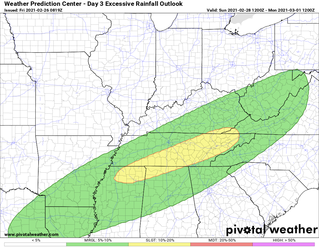
The images below are from the WPC. Their totals are a bit lower than our current forecast. I wanted to show you the comparison.
24-hour precipitation outlook.
.
 .
.
48-hour precipitation outlook.
.
.
72-hour precipitation outlook.
.
.
![]()

![]()
..
Weather advice:
Monitor river levels over the coming weeks.
Avoid flooded roadways. Heavy rain is possible over the weekend. Mainly, Saturday night.
.
Weather Discussion
-
- Rain chances.
- Locally heavy rain (esp Saturday night).
- No accumulating snow or ice in the forecast.
.
Forecast Discussion
No major changes to the going outlook.
I updated all the graphics below.
There was a slight shift northward with the heavy rain Saturday night. With that said, even now the models don’t agree on this.
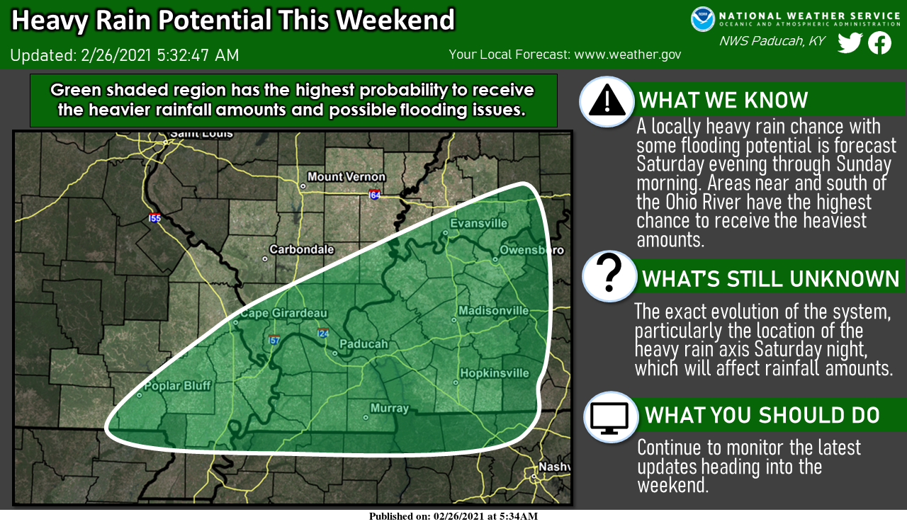
The WPC has placed portions of our region in a risk of enhanced rainfall. What does that mean? It simply means that locally heavy rain will be possible.
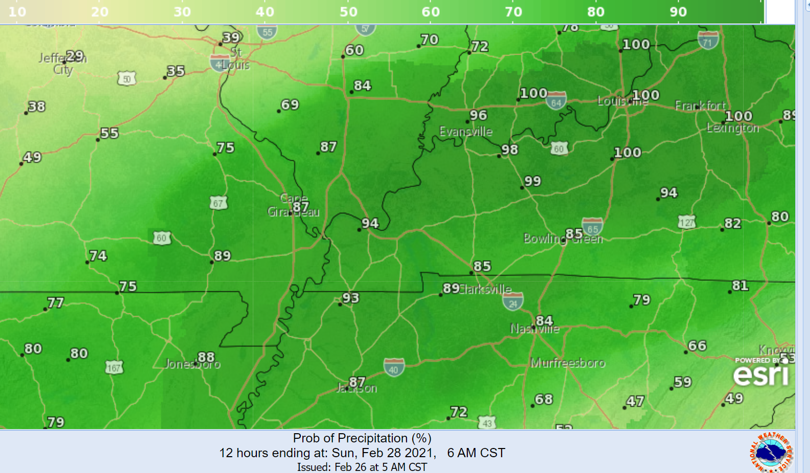
This first graphic covers Saturday night. The yellow zone has a higher risk of heavy rain vs the green zone. This may still need to be adjusted.
Either way, some locally heavy rain is likely in our region. Some roads may flood.
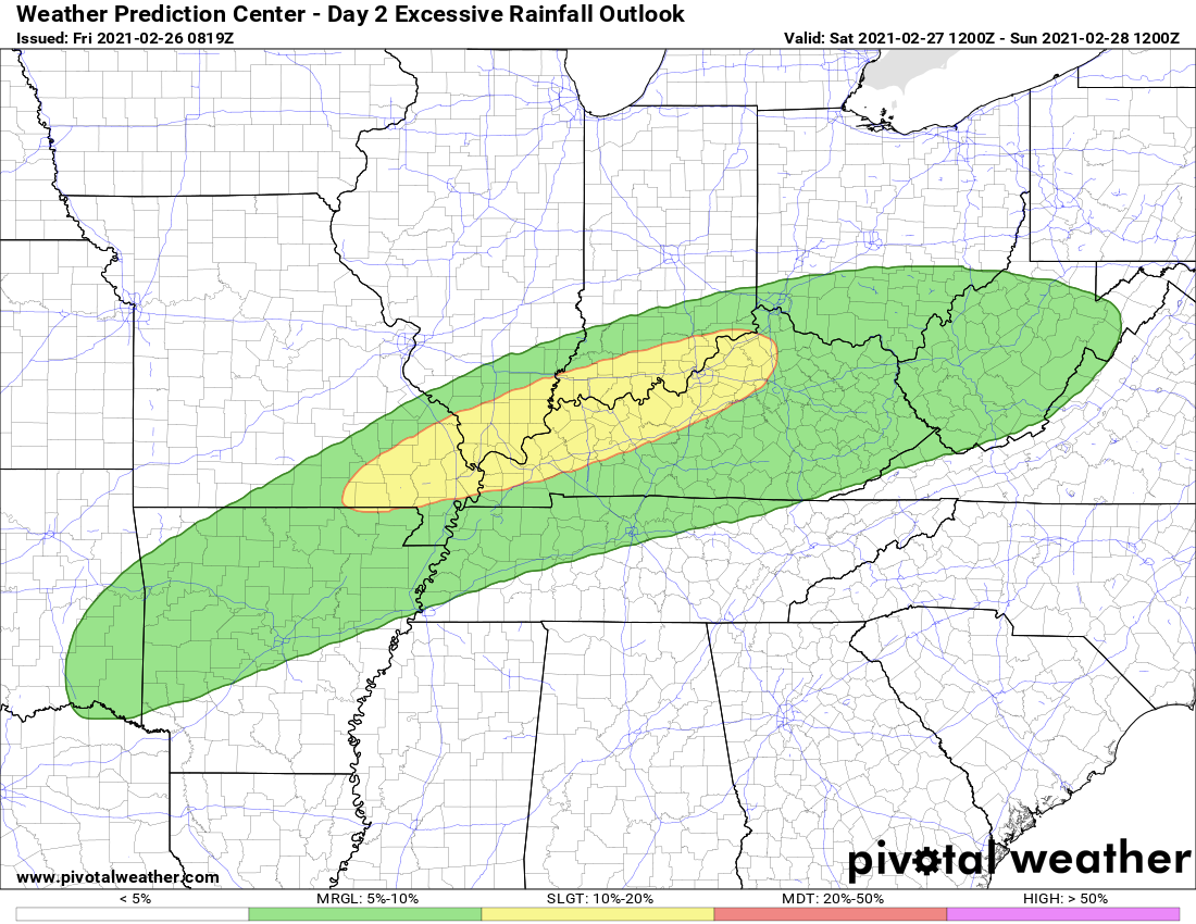
This next graphic covers Sunday. You can see, the heavier rain shifts southward with time.
.
The primary concern will be Saturday night. Thunderstorms may also form. No severe concerns. Heavy rain will be the end result of the heavy rain.
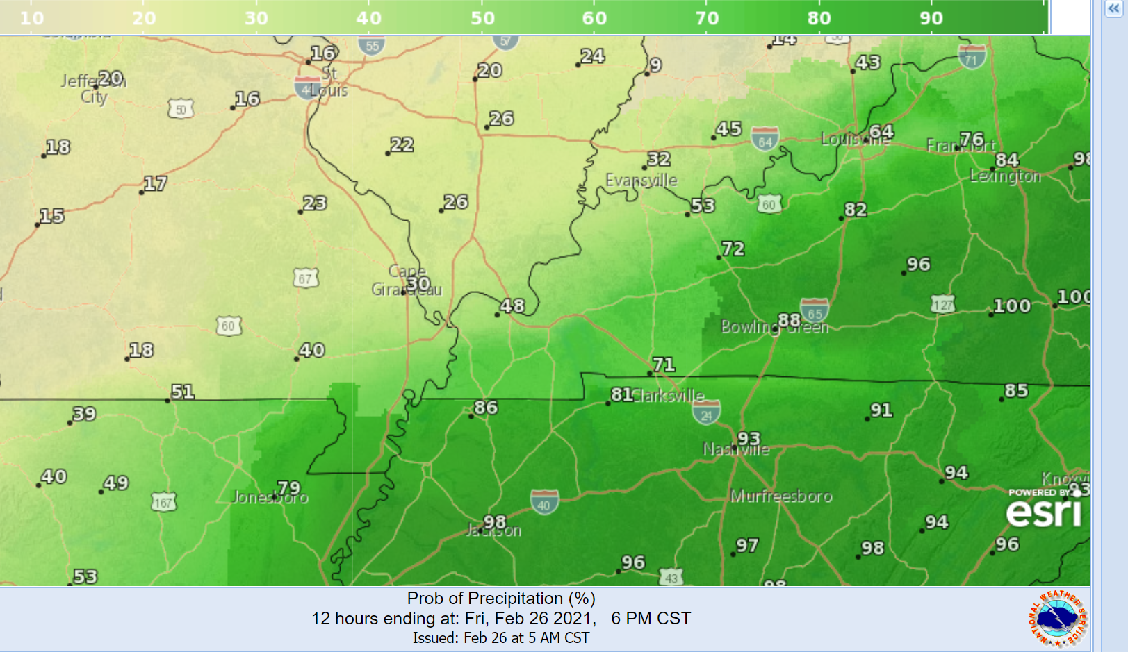
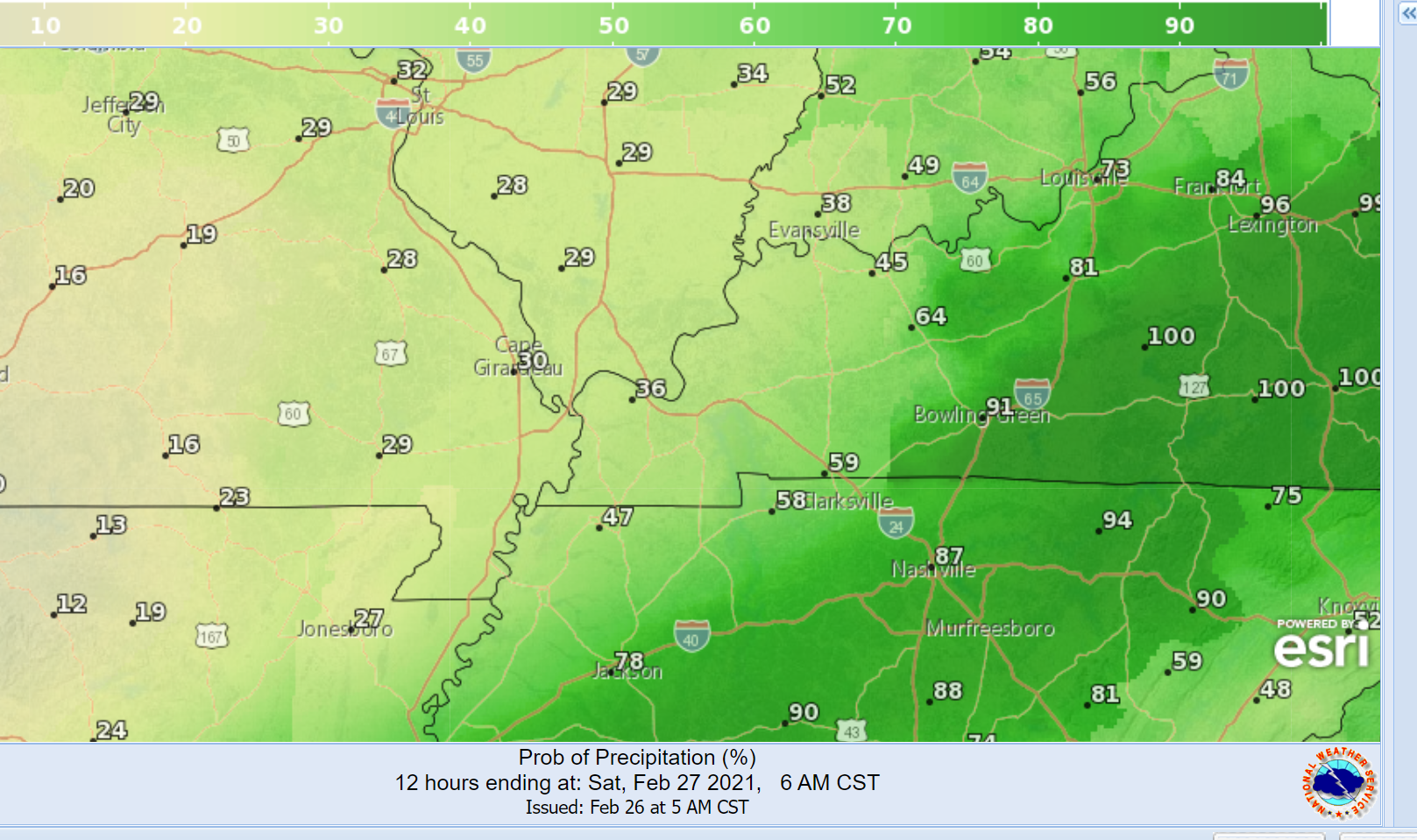
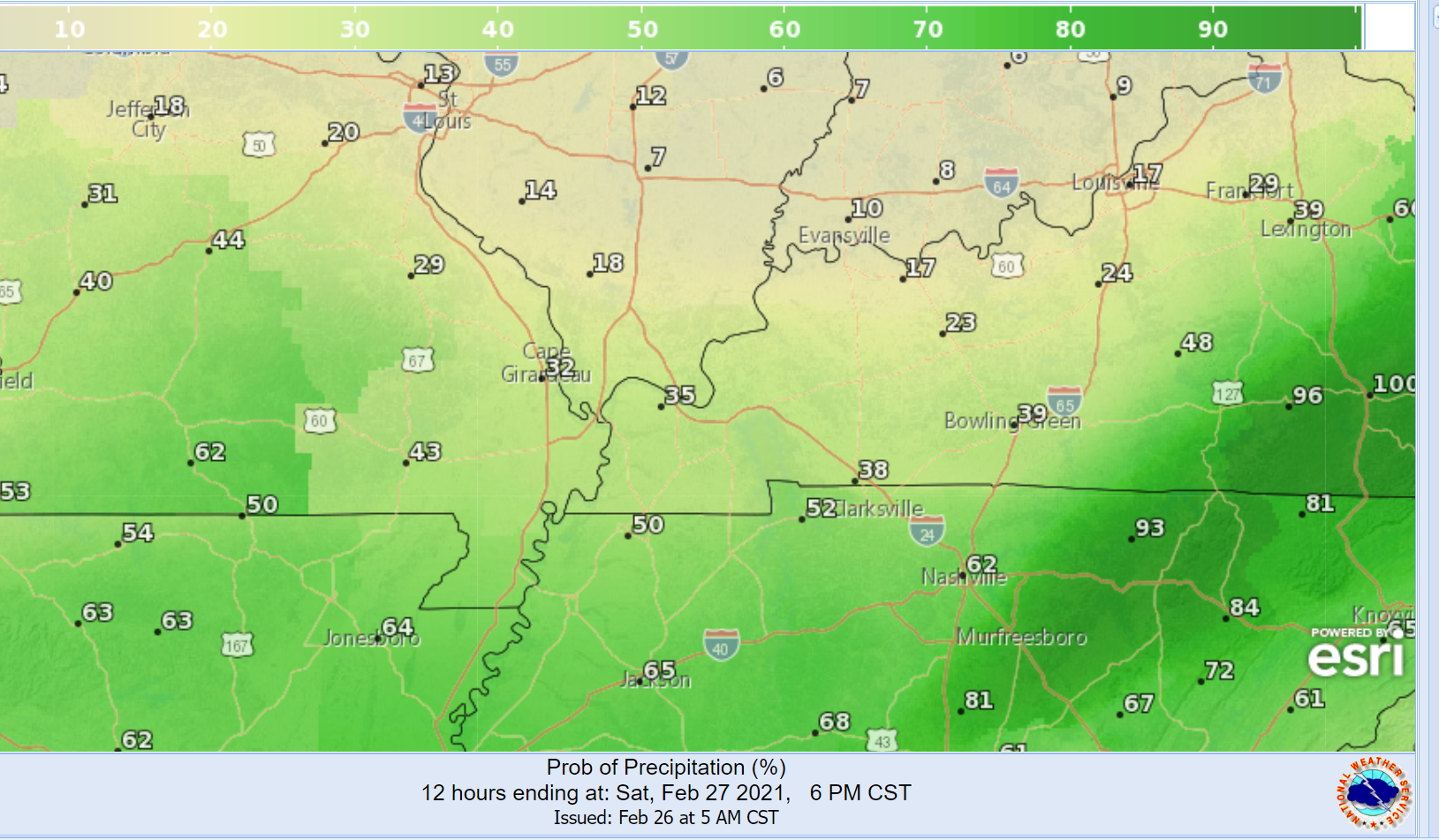
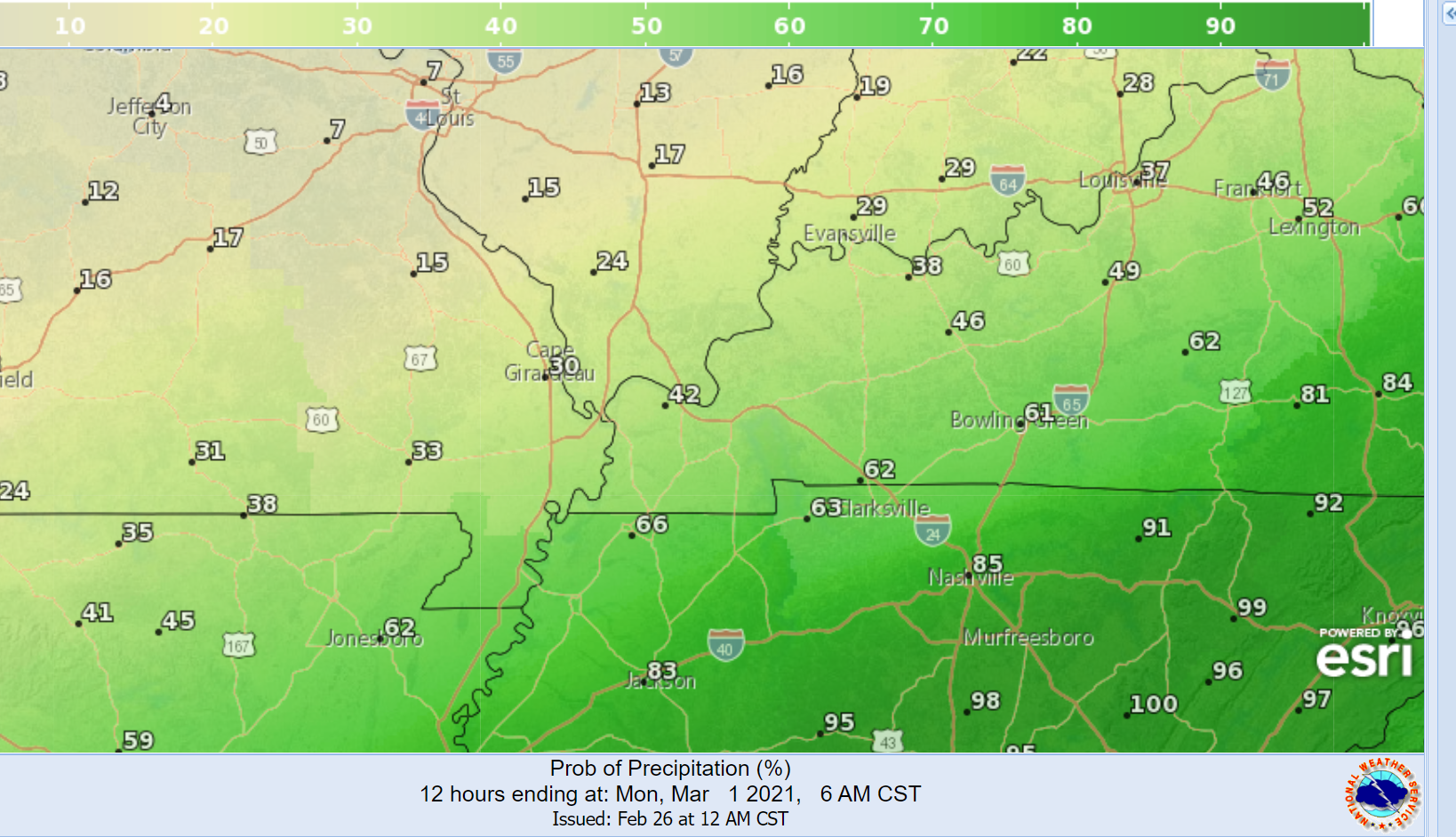
The easier way for me to show you the rain probabilities will be through a series of graphics. These graphics cover 12-hour time periods.
Take the general idea from these graphics. It won’t be perfect.
There may be some lightning Saturday night and Sunday. No severe weather, thankfully.
See the future-cast radars further down in this blog update. That will give you an idea on each system.
.
Today and Tonight
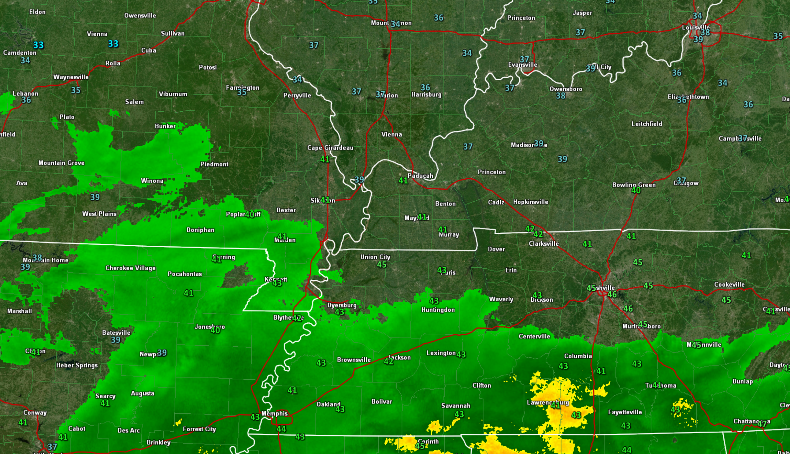
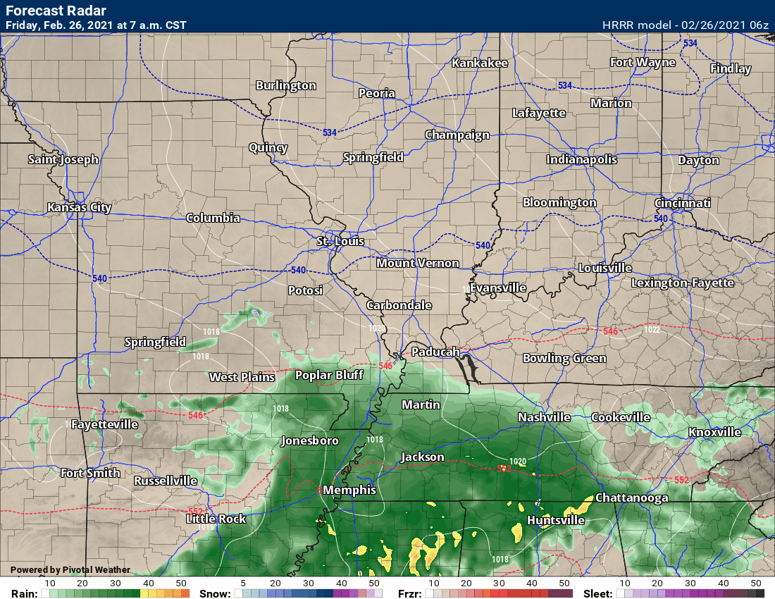
We do have some rain in the region this morning. That rain will continue on and off into the weekend.
Today’s rain is focused on the Missouri Bootheel, western Kentucky, and northwest Tennessee. Rain chances become lower and lower as you move northward.
There could be some wet snowflakes mixed with the rain this morning. No concerns for icy roads or anything else. No big deal.
Here is the 6:30 AM still shot of radar (see the radar links at the bottom of the blog for real-time imagery.
.
Friday night into Tuesday.
On and off rain chances into Sunday night. Rain chances should come to an end by Monday and Monday night. Perhaps another weak system Tuesday/Tuesday night (low confidence on that one).
There will be time-periods when rain chances will peak. That will be Saturday night into Sunday.
That means that rain chances will look like this.
Let me show you a series of graphics that show you the probability of rain during each 12-hour time period.
Double click on the images to enlarge them.
Friday
.
Friday night
.
Saturday
.
Saturday night
Double click on the images to enlarge them.
.
Sunday
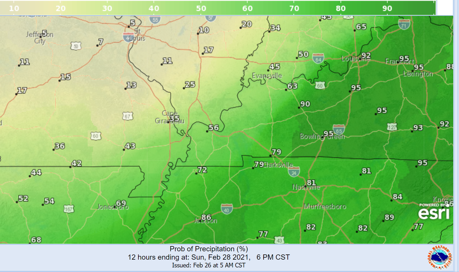
.
Sunday night
Here is the WPC/NOAA rainfall forecast.
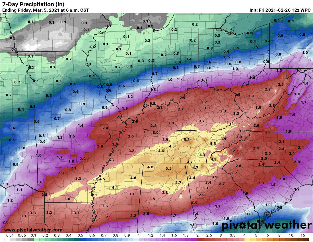
Paducah, Kentucky, NWS graphic.
.
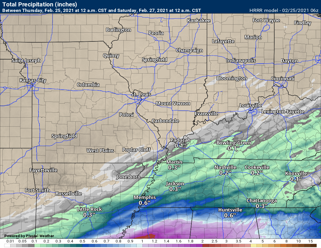
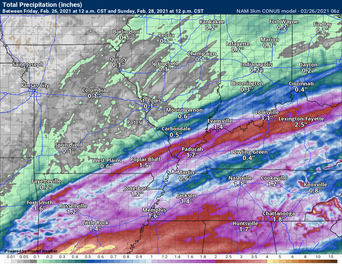
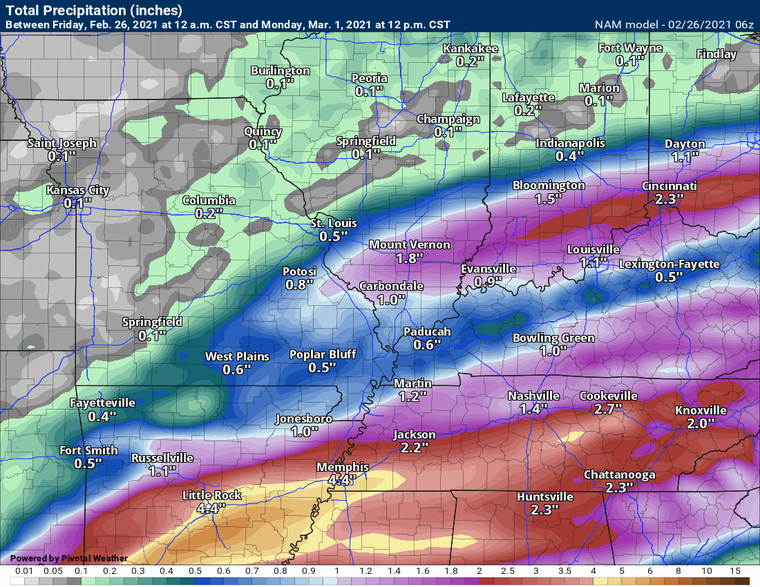
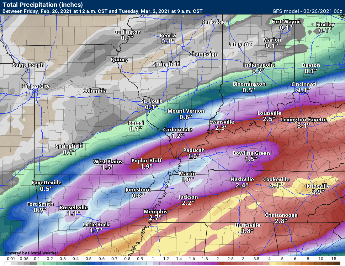
Let me show you some models and their forecast rain totals.
Notice these are not for the same time periods.
Some of the models go out further than others.
Rain totals through Saturday 12 AM.
Rain totals through Sunday 12 PM
Rain totals through Monday 12 pm.
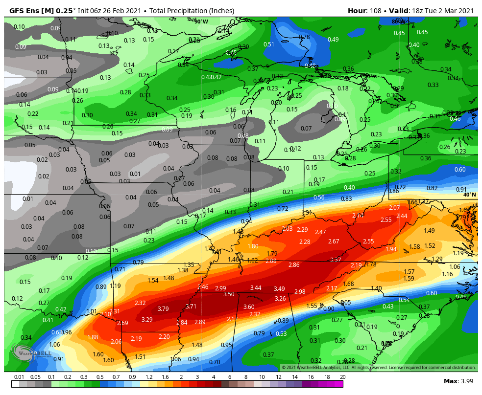
GFS model. Rain totals through next Tuesday.
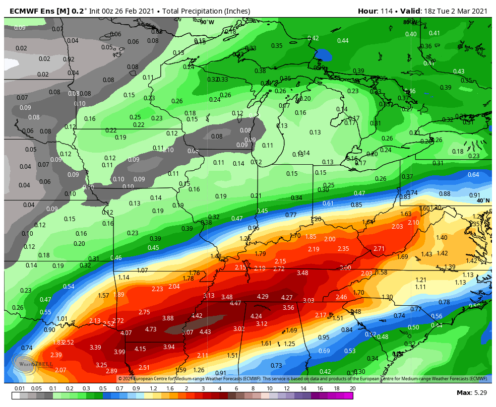
EC model. Rain totals through next Tuesday.
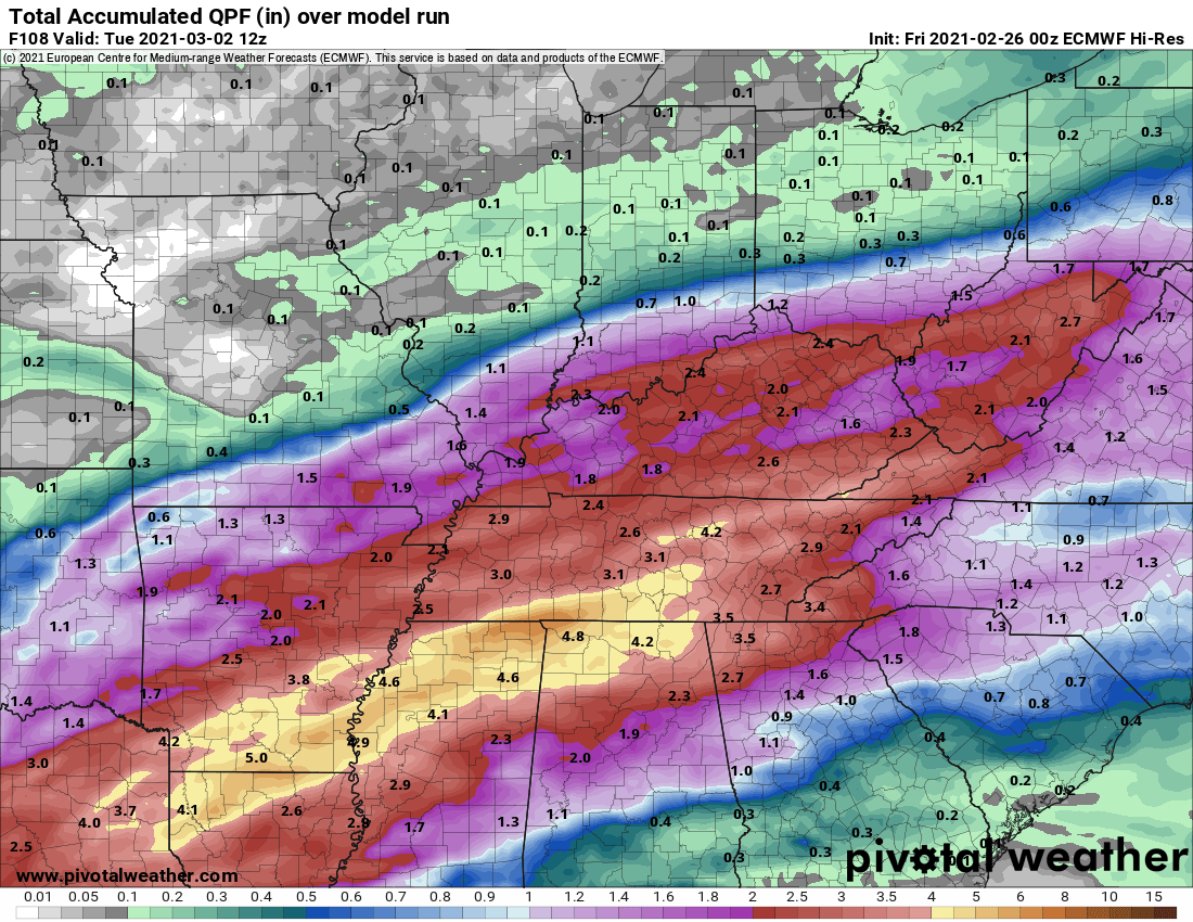
You cam tale the general idea from those graphics. More rain south. Less rain north.
At this time, severe weather appears a no-go through next Tuesday. I can’t 100% rule out lightning Sunday.
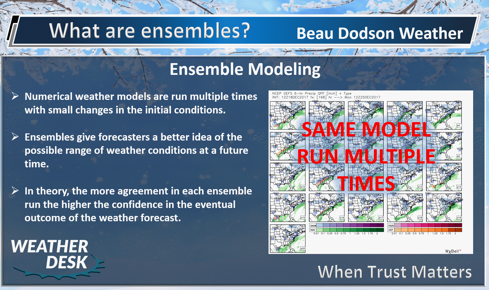
Let me show you some ensemble graphics.
What are ensembles?
First, the EC ensembles.
A few rain events will be possible. Especially, over our southern counties.
Questions remain on how far north to take the precipitation. Notice the higher totals are over the Tennessee Valley.
These maps represent the Mean of the ensembles.
Double click on the images to enlarge them.
This is through Tuesday.
GFS model. Rain totals through Tuesday. These maps represent the Mean of the ensembles.
.
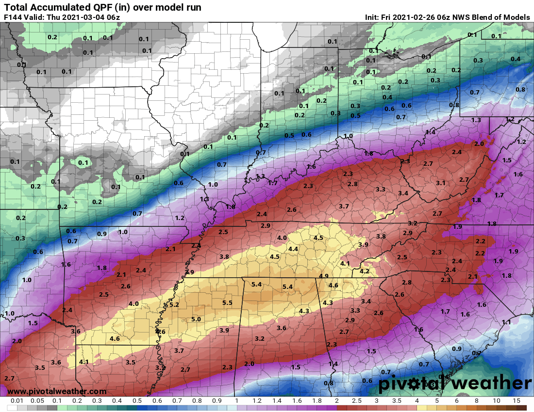
Here is a new model. The NWS Blend of Models. This is just what it sounds like. It blends a bunch of models together.
Again, notice the placement of heavier rain totals south vs north.
.
.


Click here if you would like to return to the top of the page.
Again, as a reminder, these are models. They are never 100% accurate. Take the general idea from them.
What should I take from these?
- The general idea and not specifics. Models usually do well with the generalities.
- The time-stamp is located in the upper left corner.
- The EC European weather model is in Zulu time.
.
What am I looking at?
You are looking at different models. Meteorologists use many different models to forecast the weather. All models are wrong. Some are more wrong than others. Meteorologists have to make a forecast based on the guidance/models.
I show you these so you can see what the different models are showing as far as precipitation. If most of the models agree, then the confidence in the final weather forecast increases.
You can see my final forecast at the top of the page.
.
This animation is the Storm Prediction Center WRF model.
This animation shows you what radar might look like as the next system pulls through the region. It is a future-cast radar.
Time-stamp upper left. Click the animation to enlarge it.
.
This animation is the Hrrr short-range model.
.
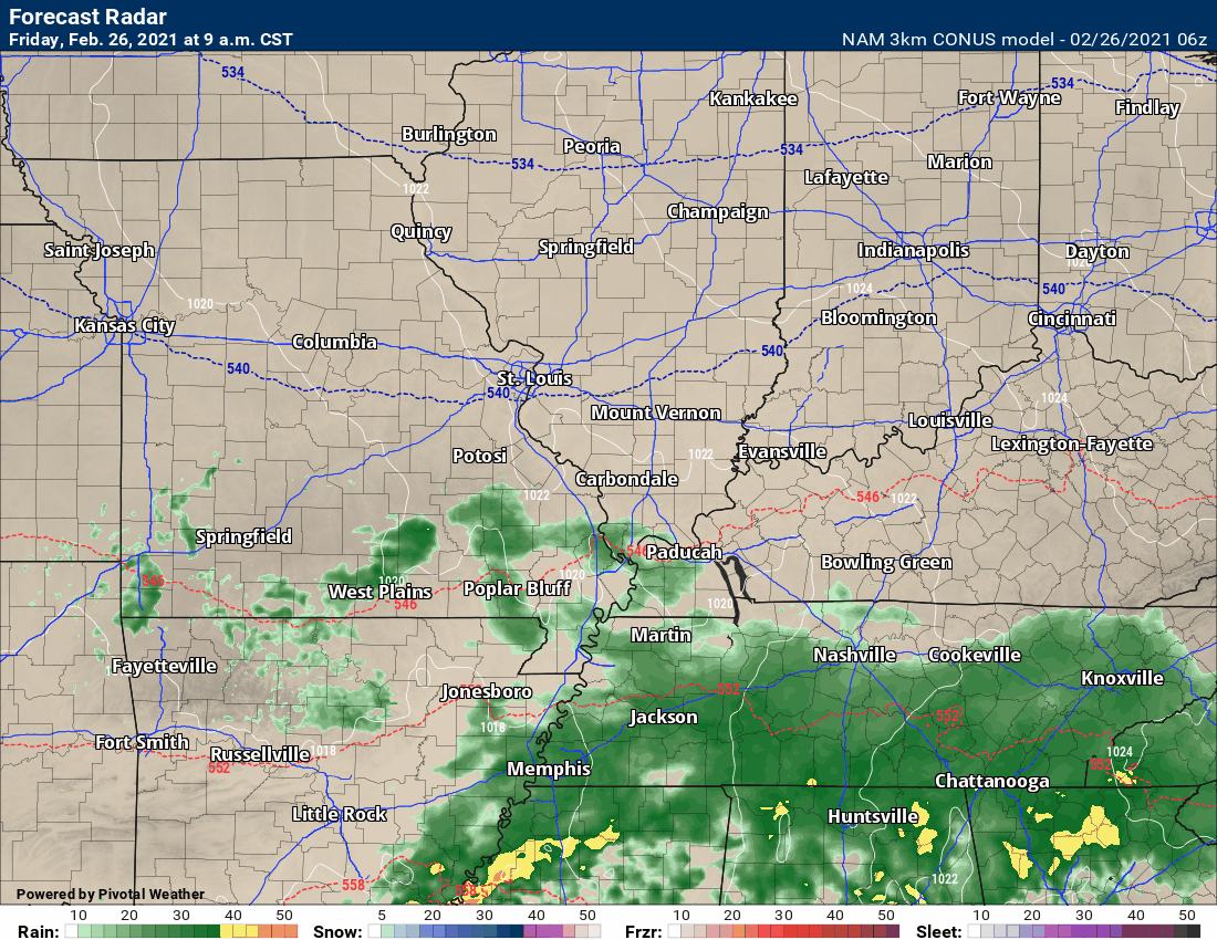
This animation is the 3K NAM American Model.
This animation shows you what radar might look like as the next system pulls through the region. It is a future-cast radar.
Time-stamp upper left. Click the animation to enlarge it.
.
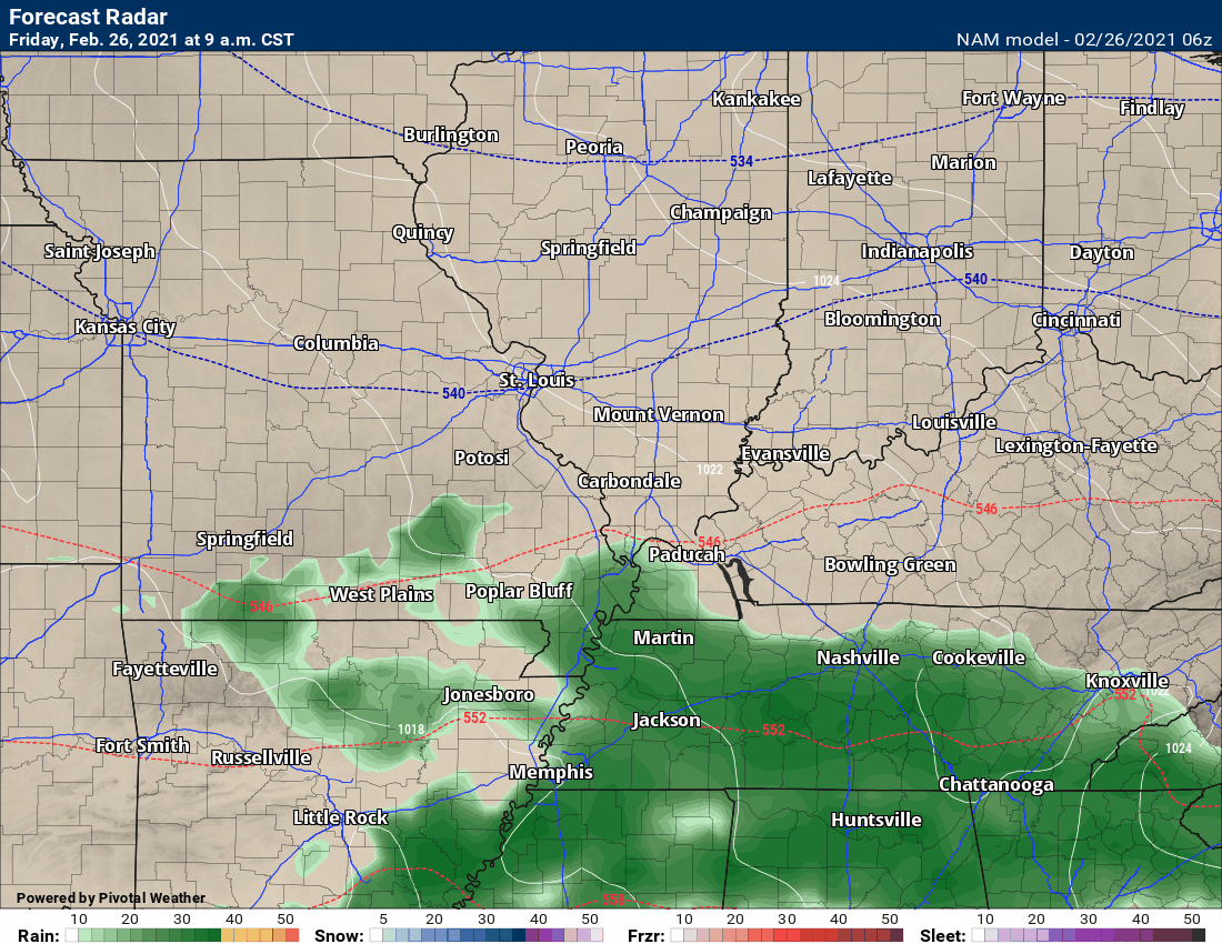
This next animation is the lower-resolution NAM American Model.
This animation shows you what radar might look like as the system pulls through the region. It is a future-cast radar.
Time-stamp upper left. Click the animation to enlarge it.
.
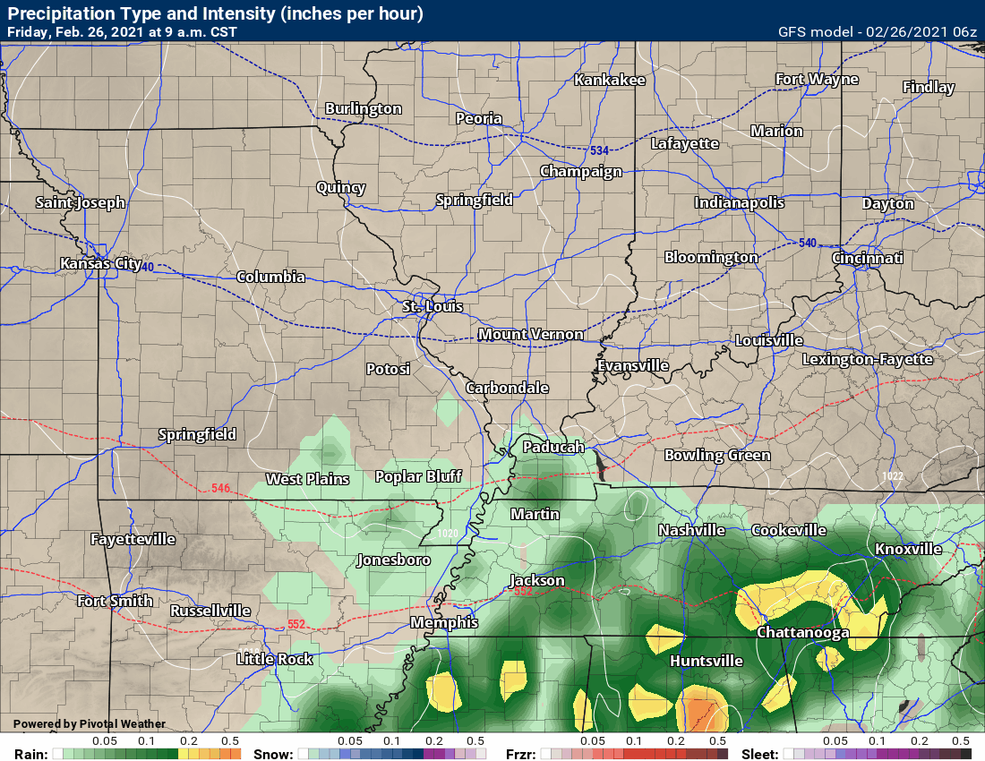
This next animation is the GFS American Model.
This animation shows you what radar might look like as the system pulls through the region. It is a future-cast radar.
Time-stamp upper left. Click the animation to enlarge it.
The system later today and tonight. Weak event.
Short-range. The GFS pops some light sprinkles along the incoming Wednesday cold front. Do not expect much if anything at all.
.
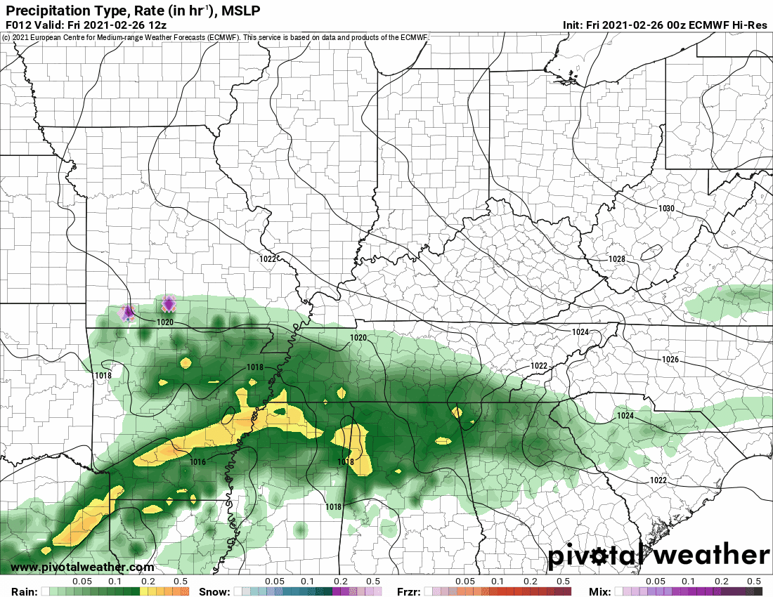
This next animation is the EC European Weather model.
This animation shows you what radar might look like as the system pulls through the region. It is a future-cast radar.
Time-stamp upper left. Click the animation to enlarge it.
.
.
![]()
.


.
Click here if you would like to return to the top of the page.
.
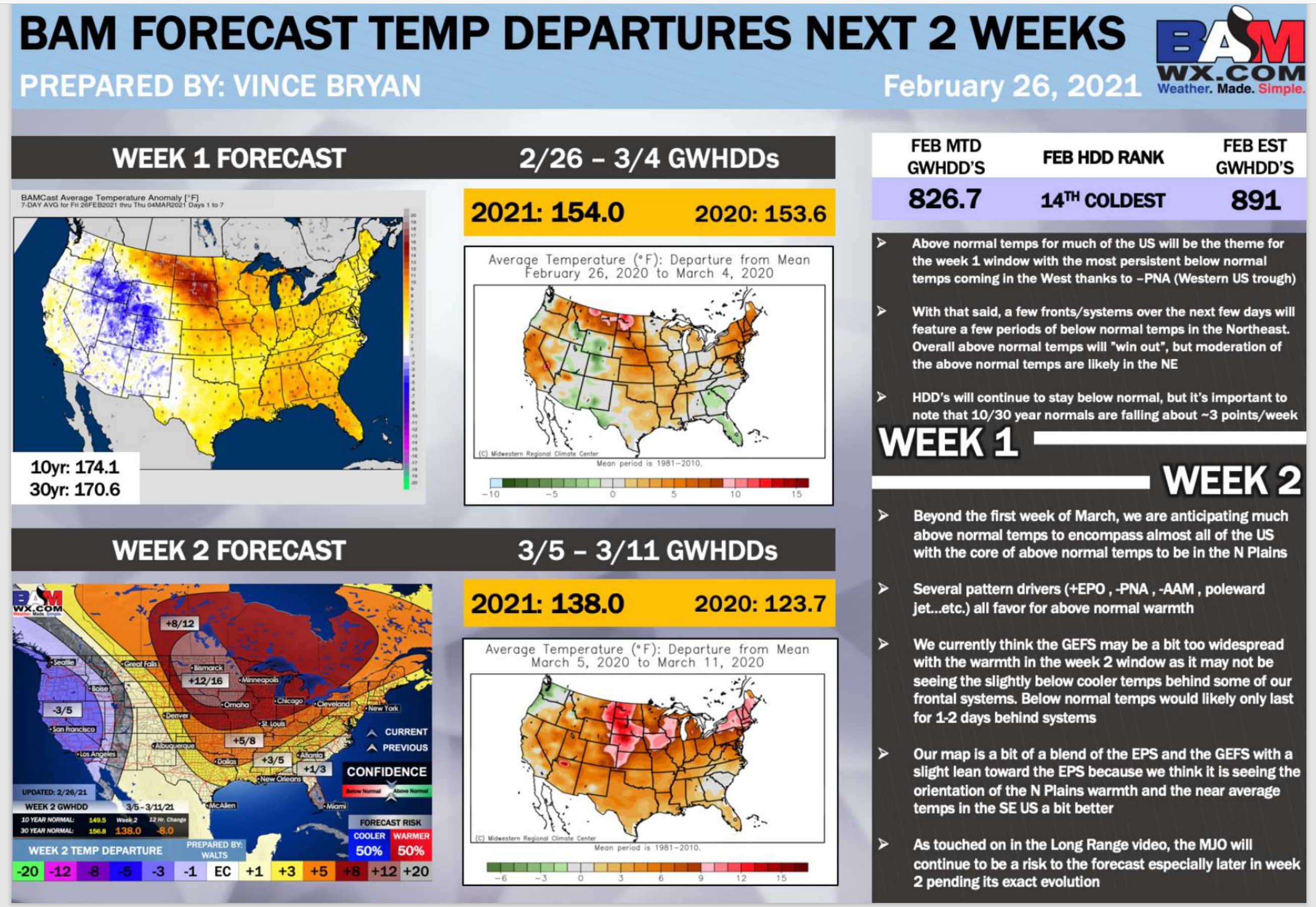
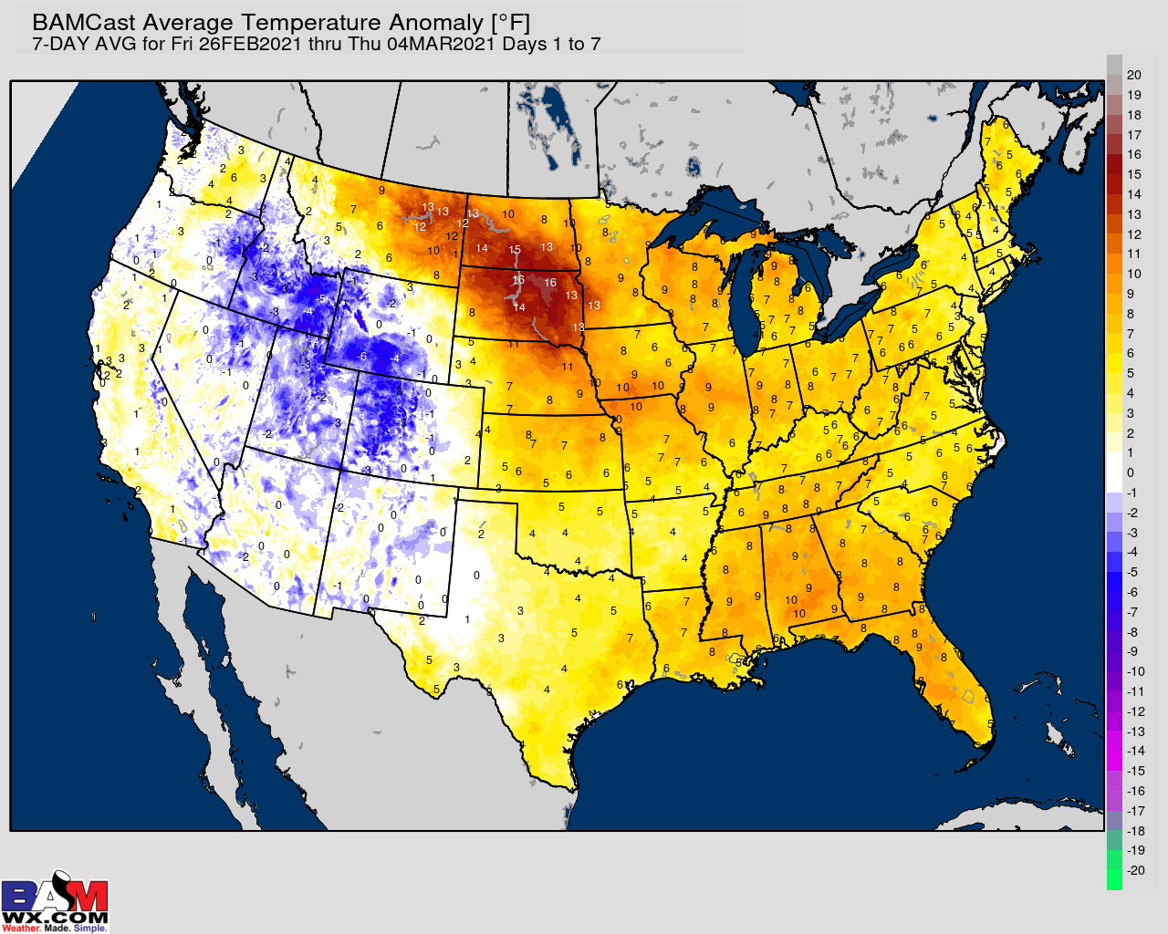
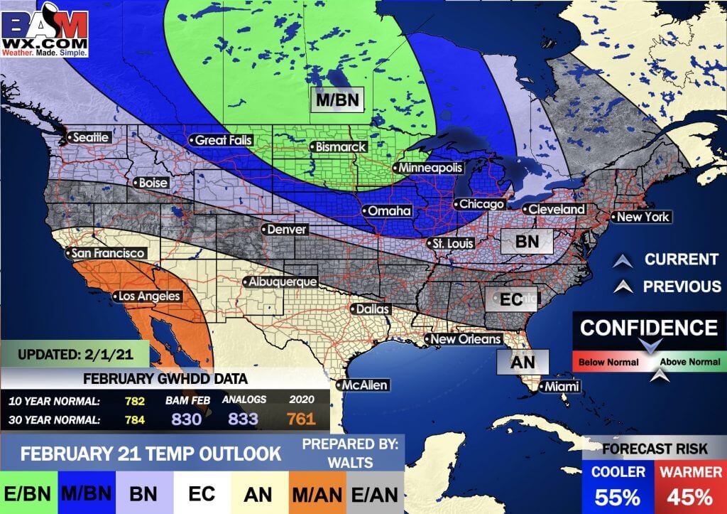
Average high temperatures for this time of the year are around 53 degrees.
Average low temperatures for this time of the year are around 34 degrees.
Average precipitation during this time period ranges from 0.70″ to 1.00″
Yellow and orange colors are above average temperatures. Red is much above average. Light blue and blue are below-average temperatures. Green to purple colors represents much below-average temperatures.
This outlook covers February 26th through March 4th
Click on the image to expand it.
.
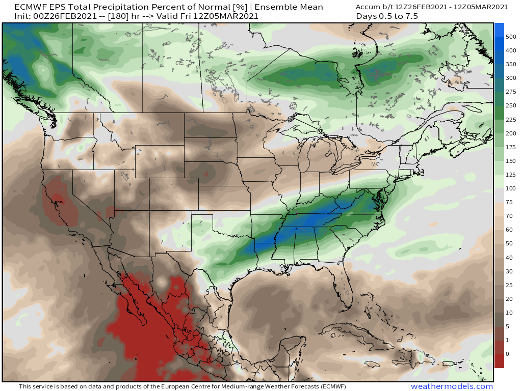
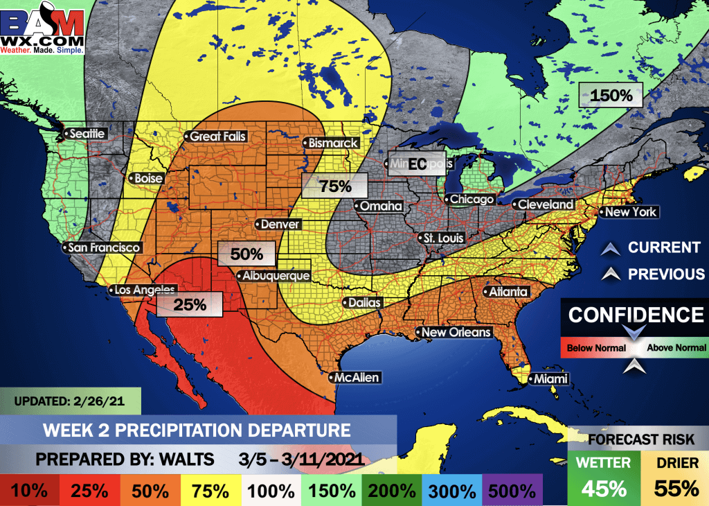
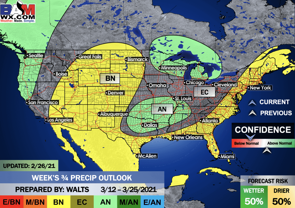
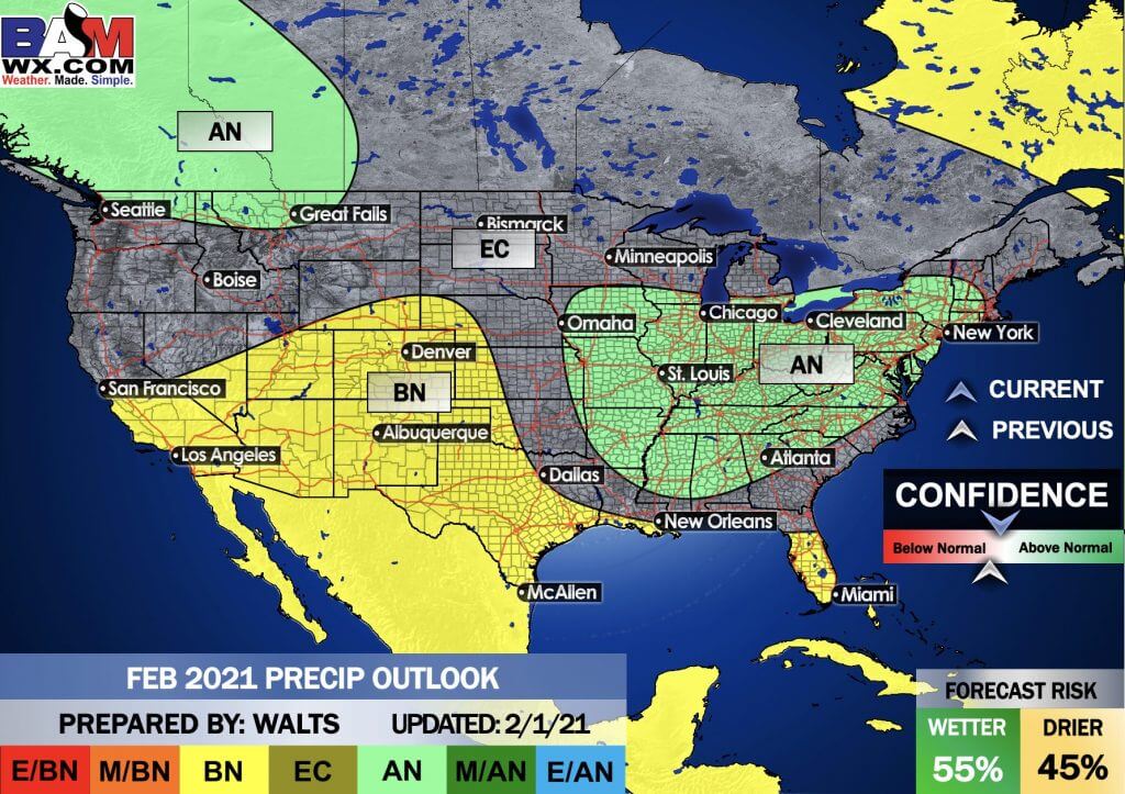
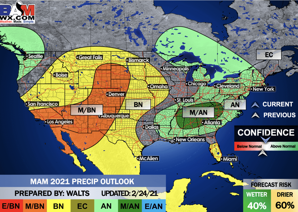
The precipitation forecast is PERCENT OF AVERAGE. Brown is below average. Green is above average. Blue is much above average.
.

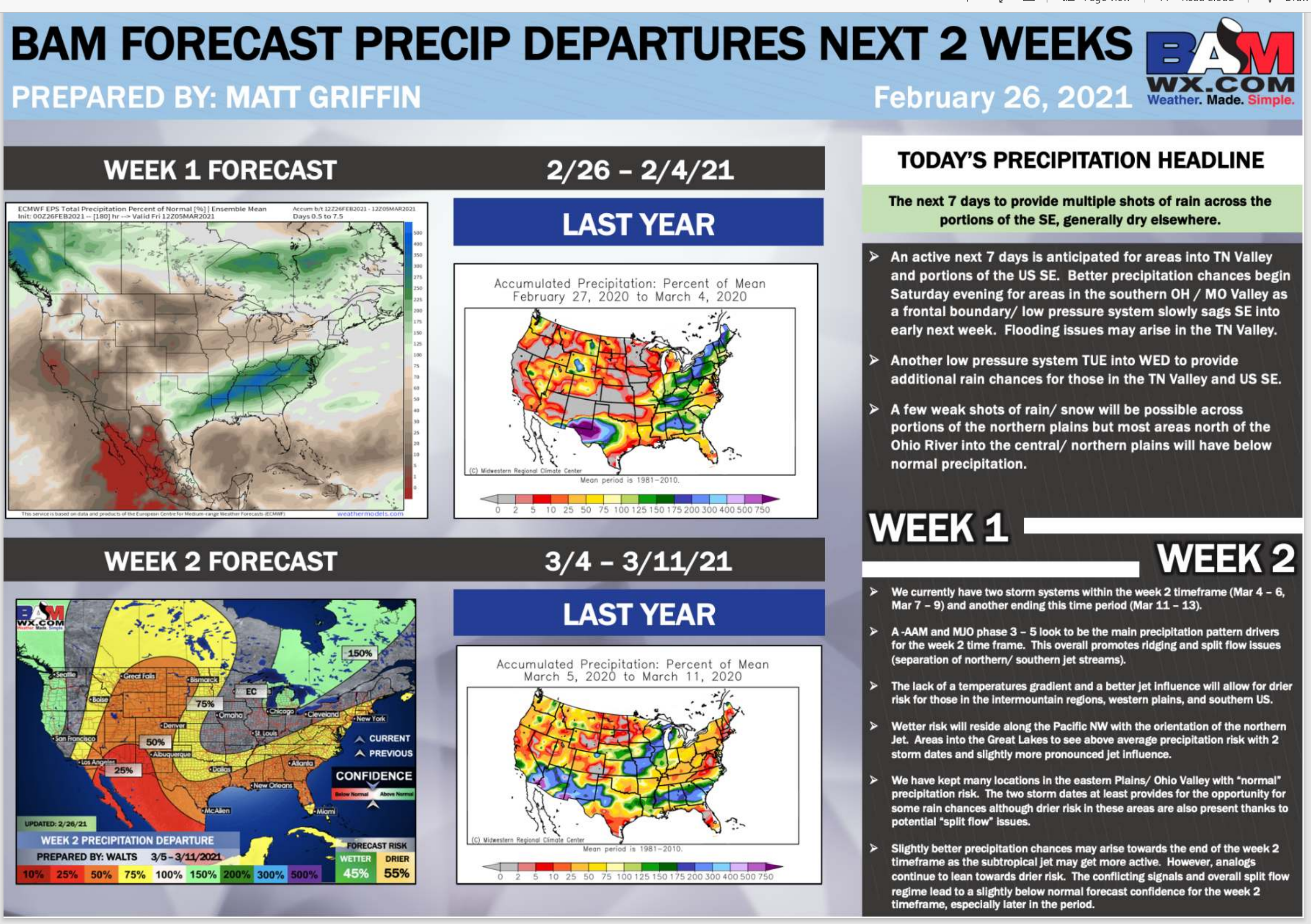
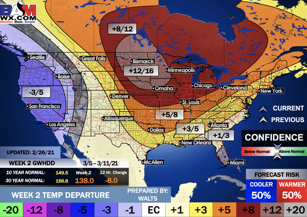
Average low temperatures for this time of the year are around 35 degrees
Average precipitation during this time period ranges from 0.70″ to 1.00″
.
This outlook covers March 5th through March 11th
Click on the image to expand it.
.
The precipitation forecast is PERCENT OF AVERAGE. Brown is below average. Green is above average. Blue is much above average.
.
.

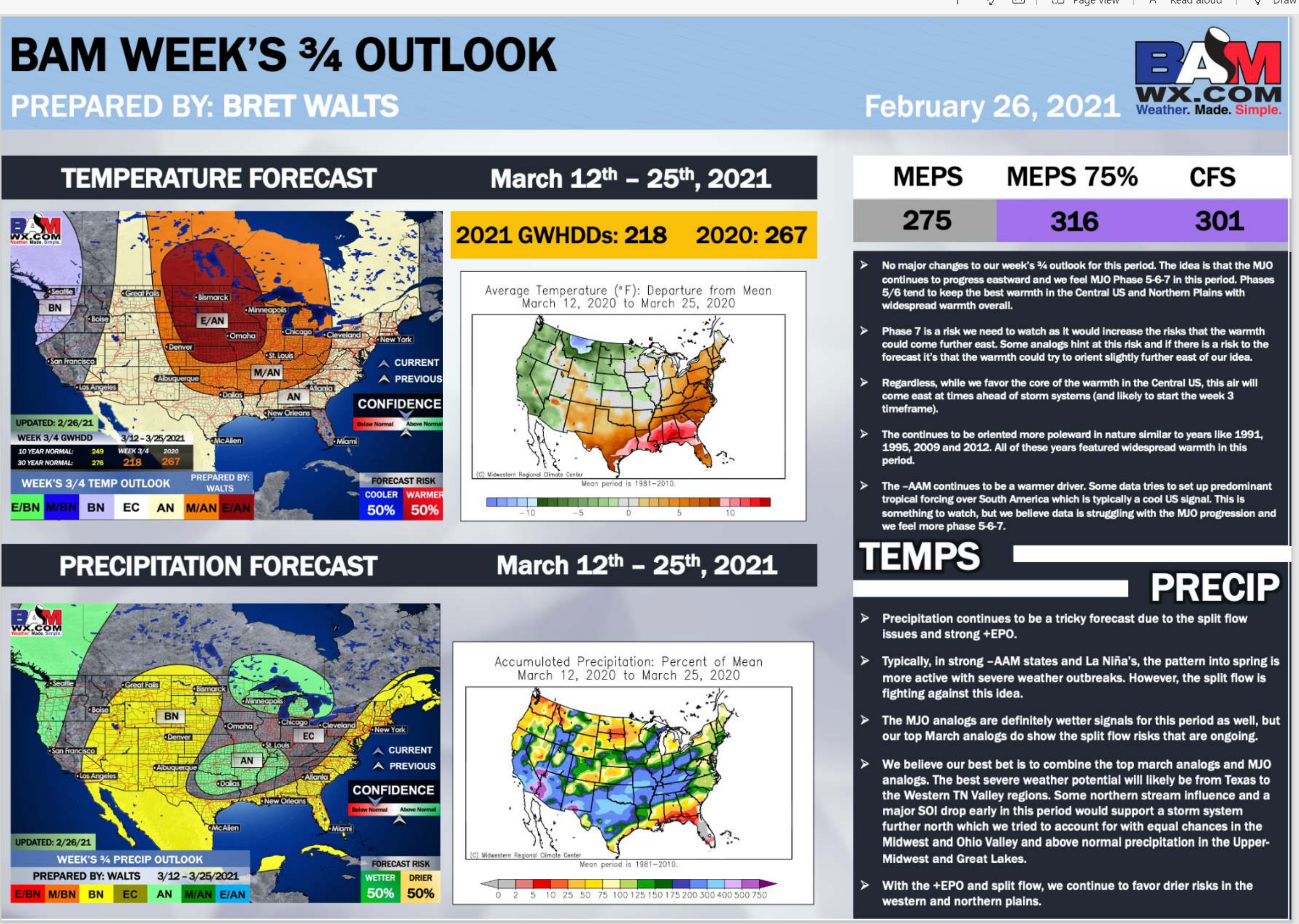
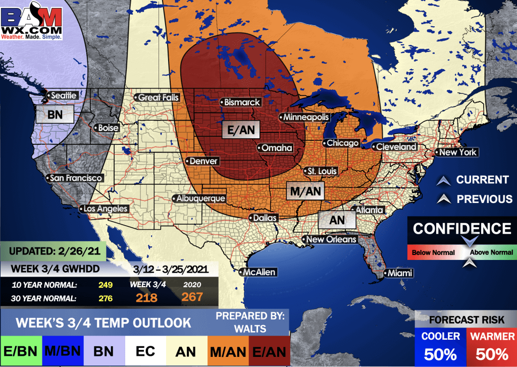
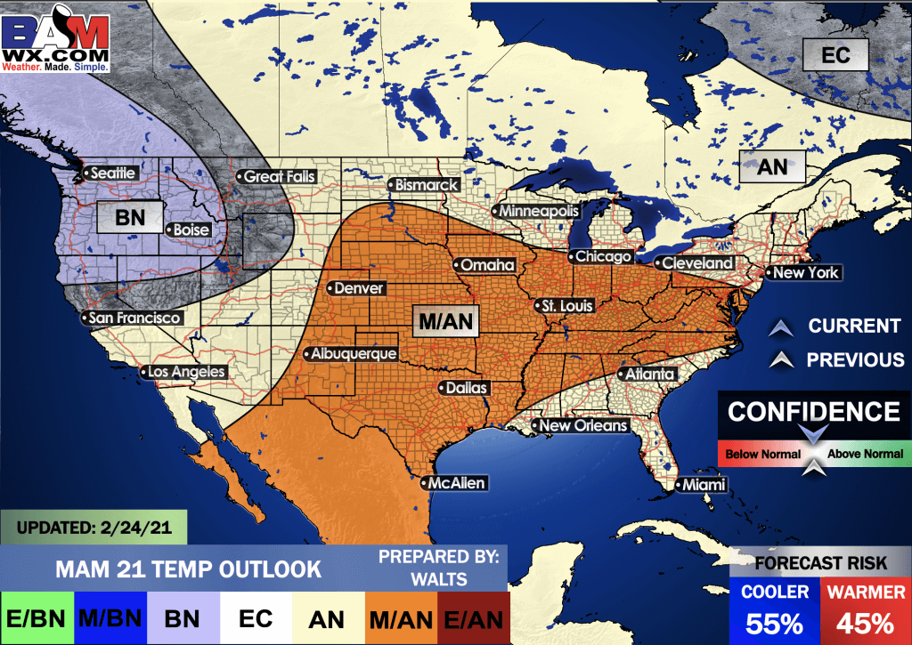
EC = Equal chances of above or below average
BN= Below average
M/BN = Much below average
AN = Above average
M/AN = Much above average
E/AN = Extremely above average
Average low temperatures for this time of the year are around 40 degrees
Average precipitation during this time period ranges from 1.40″ to 2.00″
This outlook covers March 12th through March 25th
.
Precipitation outlook
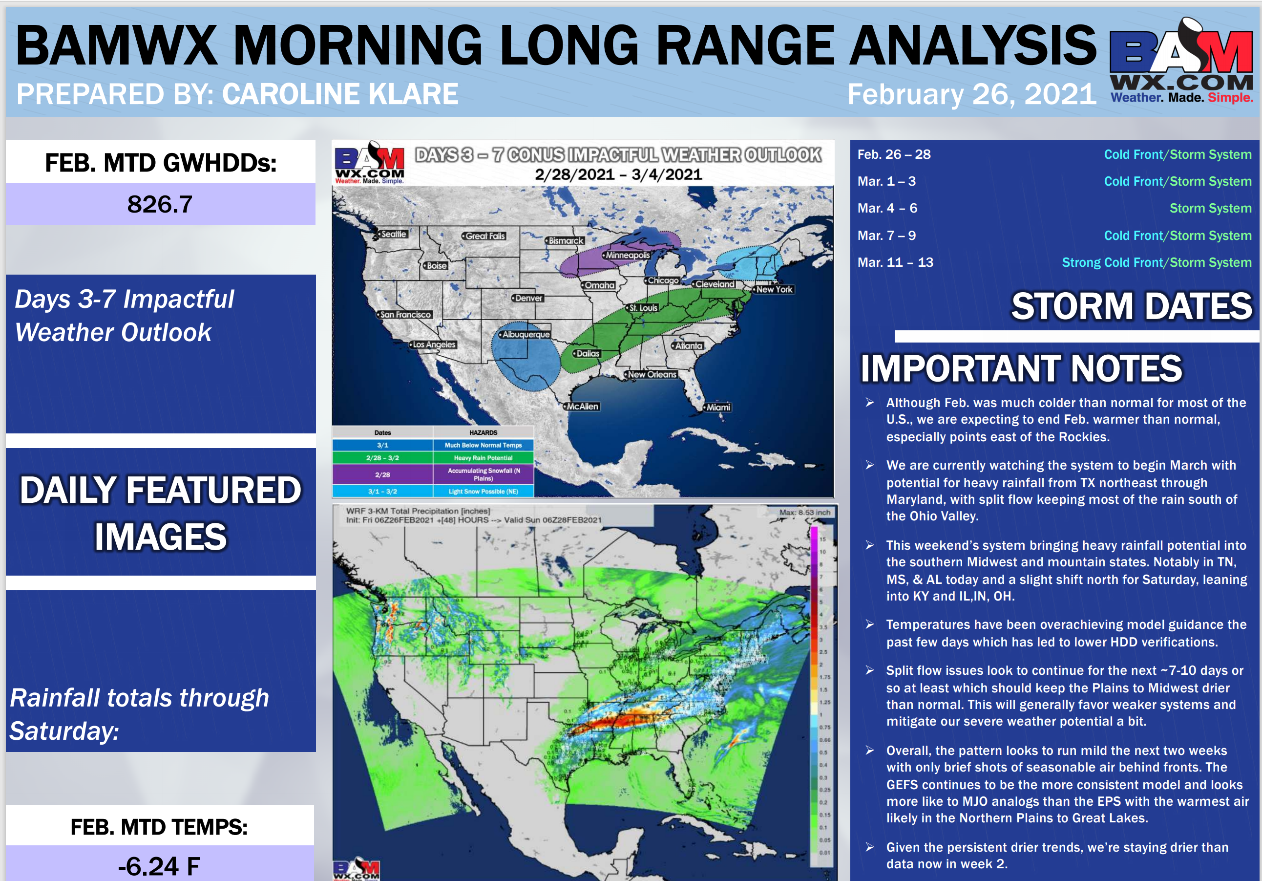
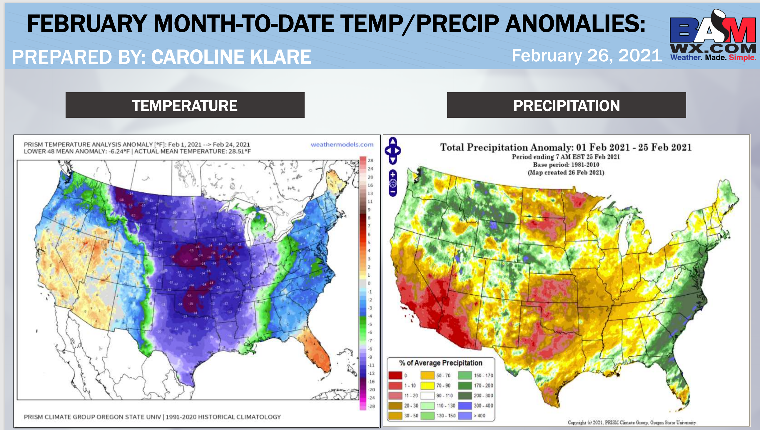
LONG RANGE DISCUSSION
Key Points: This was written by the BAMwx team. I don’t edit it.
.
E/BN extremely below normal.
M/BN is much below normal
EC equal chances
AN above normal
M/AN much above normal
E/AN extremely above normal.
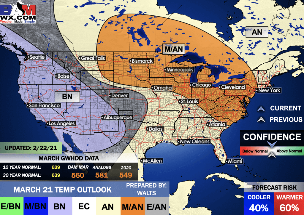
February Temperature Outlook
.
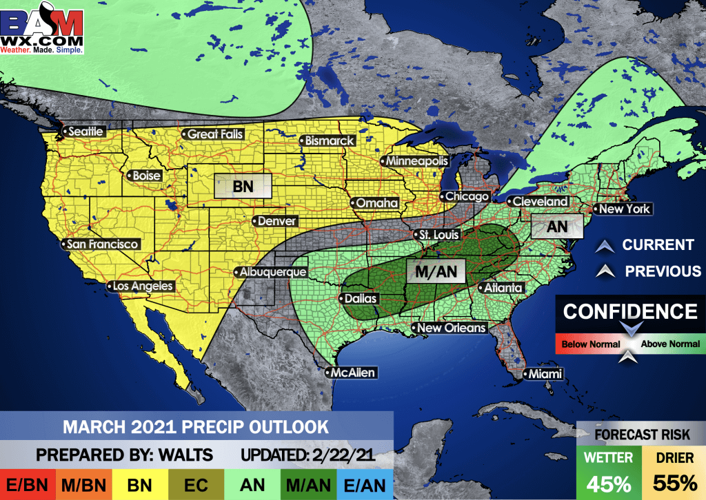
February Precipitation Outlook
.
Spring Outlook
E/BN extremely below normal.
M/BN is much below normal
EC equal chances
AN above normal
M/AN much above normal
E/AN extremely above normal.
March, April, and May Temperature Outlook
.
March, April, and May Precipitation Outlook
.
E/BN extremely below normal.
M/BN is much below normal
EC equal chances
AN above normal
M/AN much above normal
E/AN extremely above normal.
And the preliminary March outlooks
Temperature departures
Precipitation
.
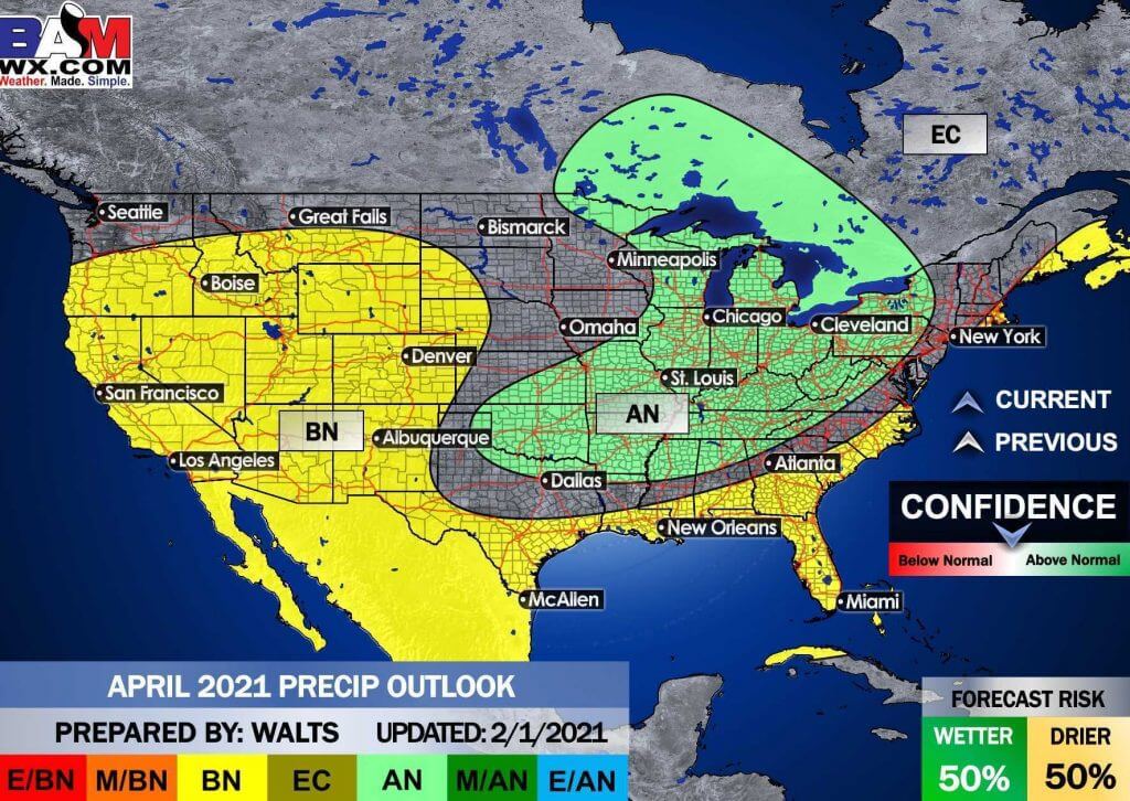
And the preliminary April outlooks
E/BN extremely below normal.
M/BN is much below normal
EC equal chances
AN above normal
M/AN much above normal
E/AN extremely above normal.
Temperature departures
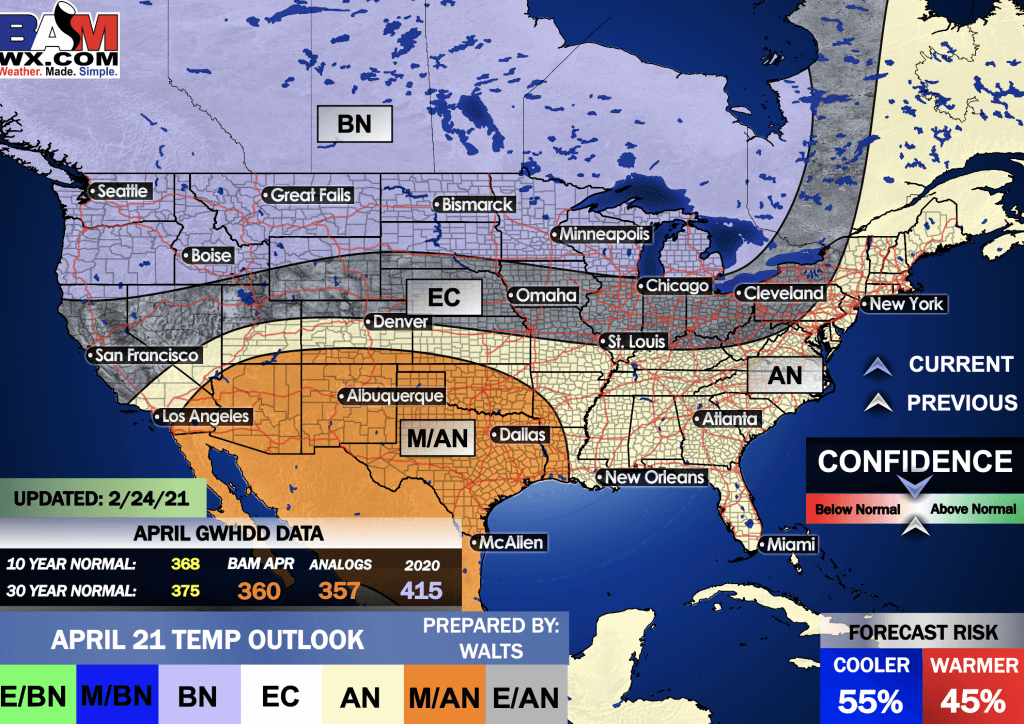
Precipitation
.
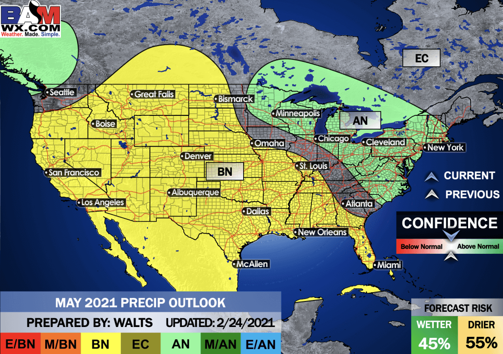
And the preliminary May outlooks
E/BN extremely below normal.
M/BN is much below normal
EC equal chances
AN above normal
M/AN much above normal
E/AN extremely above normal.
Temperature departures
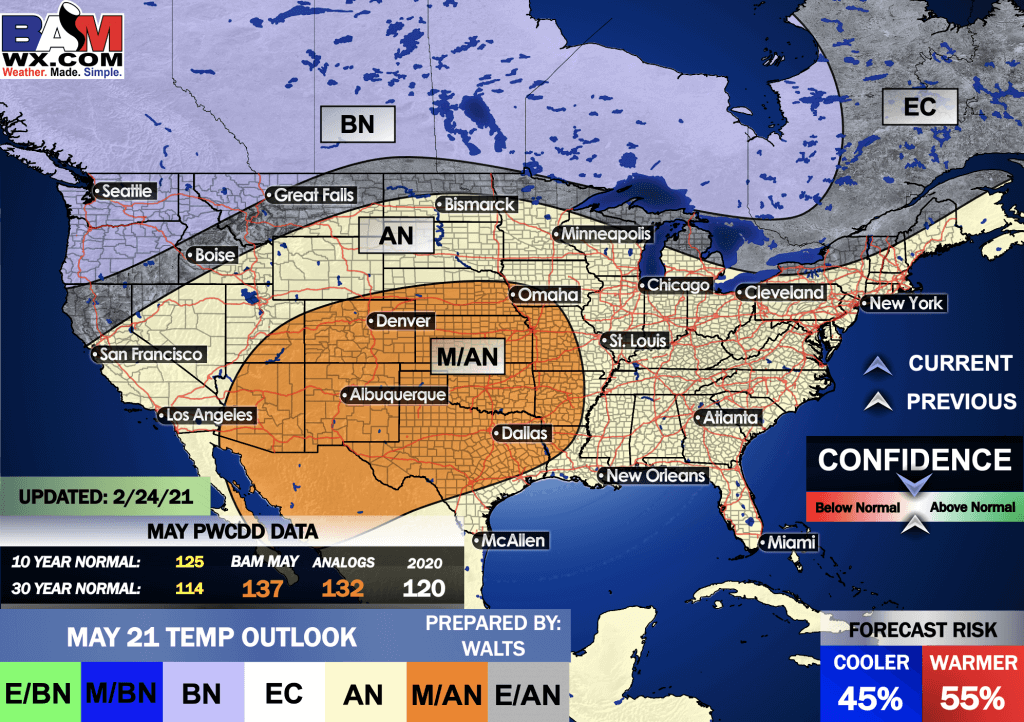
Precipitation
.
![]()

Great news! The videos are now found in your Weathertalk app and on the WeatherTalk website.
These are bonus videos for subscribers.
The app is for subscribers. Subscribe at www.weathertalk.com/welcome then go to your app store and search for WeatherTalk
Subscribers, PLEASE USE THE APP. ATT and Verizon are not reliable during severe weather. They are delaying text messages.
The app is under WeatherTalk in the app store.

Apple users click here

Android users click here
.

Radar Link: Interactive local city-view radars & regional radars.
You will find clickable warning and advisory buttons on the local city-view radars.
If the radar is not updating then try another one. If a radar does not appear to be refreshing then hit Ctrl F5. You may also try restarting your browser.
Not working? Email me at beaudodson@usawx.com
National map of weather watches and warnings. Click here.
Storm Prediction Center. Click here.
Weather Prediction Center. Click here.
.

Live lightning data: Click here.
.

Interactive GOES R satellite. Track clouds. Click here.
GOES 16 slider tool. Click here.
College of Dupage satellites. Click here
.

Here are the latest local river stage forecast numbers Click Here.
Here are the latest lake stage forecast numbers for Kentucky Lake and Lake Barkley Click Here.
.
.
Find Beau on Facebook! Click the banner.


 .
.