What you need to know.
Key Points
- A cold front will enter the region Sunday and Sunday night. It will move back into the region Monday afternoon/night.
- Multiple chances of showers and thunderstorms. Some areas may be missed Sunday. Keep that in mind.
- Thunderstorms are likely to accompany the front. Some storms could produce quarter hail and high wind gusts.
- There is a risk of severe weather both Sunday and Monday. Peak time on Sunday will be 11 AM to 4 PM. Peak time on Monday will be the mid-afternoon hours into the overnight hours.
- Have three or more ways of receiving your severe weather information. That includes my Beau Dodson Weather Talk app and a NOAA Weather Radio.
.
Call to action.
Monitor updated weather forecasts.
Make sure you are using the Weather Talk app. Download it from the app store. It is under Weather Talk.
TURN ON YOUR BEAU DODSON WEATHER TALK APP. Make sure it is on. Make sure you have not accidentally logged out of the app.
The app is for subscribers (please log into your account and make sure your payment has been updated. We have a large number of declined cards and PayPal payments.
Subscribe at www.weathertalk.com/welcome then go to your app store and search for WeatherTalk. Apple users click here. Android users click here
.
Forecast:
Updated at 4:15 PM
The severe weather threat has ended for today.
Additional severe storms are possible Monday afternoon and night.
Monitor this page.
.
Updated at 3:52 PM
Trigg, Christian, and Todd Counties. A line of storms is clipping Trigg County and is moving into southern Christian County.
The line is moving E SE at 60 mph. It may produce strong and gusty wind, small hail, heavy rain, and lightning.
The line produced widespread wind damage to your west. The good news is the worst of the storms are now in Tennessee vs Kentucky.
This will be the end of the severe weather concerns once the line passes.
We may have additional storms Monday afternoon and night. Monitor updates.
.
Updated at 3:45 PM
Local Storm Report by NWS PAH: 3 SSW Murray [Calloway Co, KY] emergency manager reports TSTM WND DMG at 03:10 PM CDT — roof peeled back from a horse barn.
(3:45:30 PM)
Local Storm Report by NWS PAH: Qulin [Butler Co, MO] broadcast media reports TSTM WND DMG at 01:30 PM CDT — trees down and roof damage. radar estimated time.
.
Updated at 3:40 PM
Local Storm Report by NWS MEG: Paris [Henry Co, TN] amateur radio reports TSTM WND DMG at 03:37 PM CDT — numerous trees and power poles snapped between Paris and Mckenzie
.
Updated at 3:38 PM
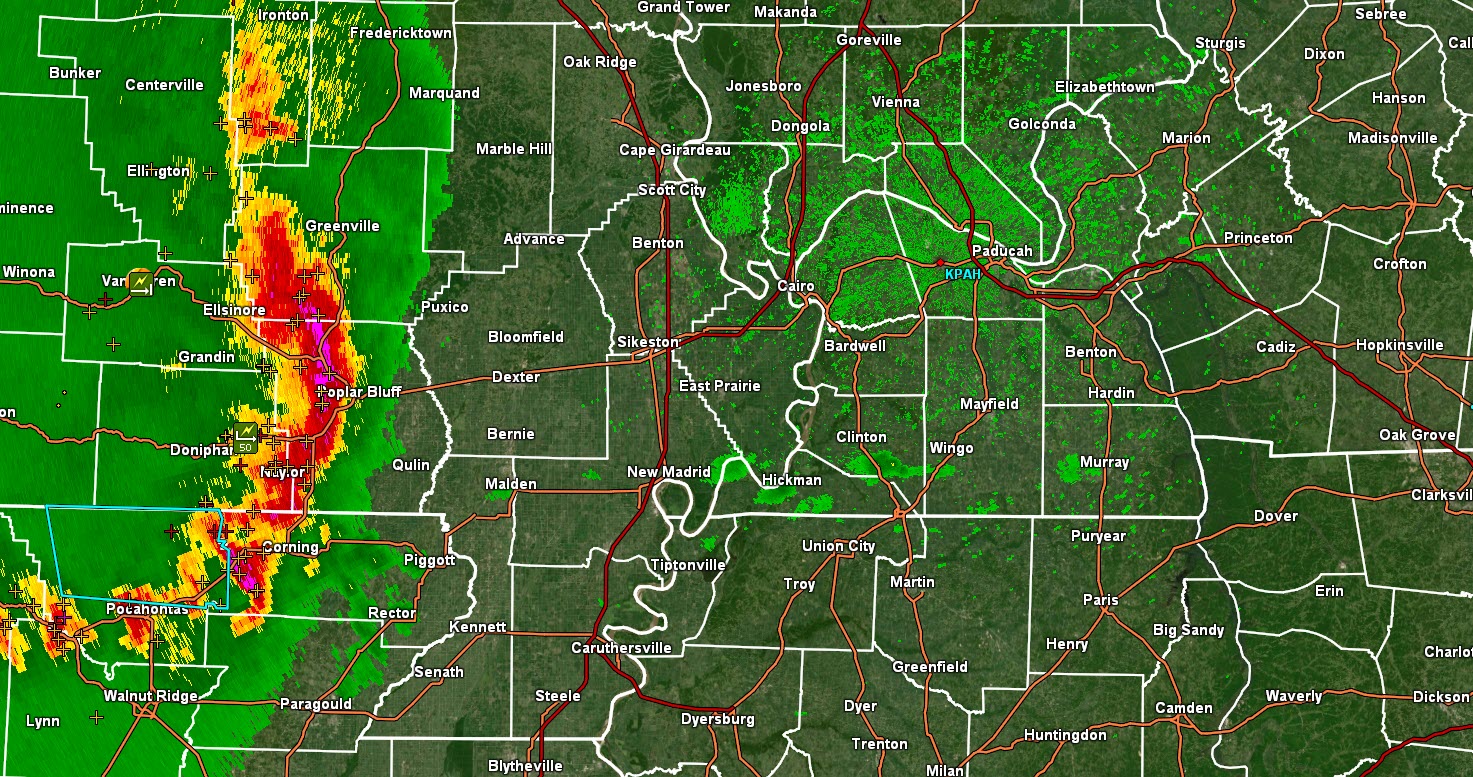
SE MO, far southern IL, NW TN, far western KY with the exception of Trigg and southern Christian County. The threat of severe weather has now ended. The main line of storms has pushed off to the east/southeast.
Widespread wind damage has been reported along the path of the main bow echo. Winds of 70+ were reported in several counties. We have roofs off houses and buildings in some counties.
Thank you for your storm reports.
We may have severe weather late Monday afternoon and night. Monitor updates.
Radar
https://weatherobservatory.com/radar_paducah.htm
.
Updated at 3:34 PM
Local Storm Report by NWS PAH: 2 SSE Brownwood [Stoddard Co, MO] public reports TSTM WND DMG at 02:15 PM CDT — tree down covering cr 216 east of hwy bb. radar estimated time.
Dispatch reports tree on power lines, causing fire, Brooks Chapel Road, 1/2 mile from Ky 464 (north of Murray)
Local Storm Report by NWS PAH: 2 SSE Brownwood [Stoddard Co, MO] public reports TSTM WND DMG at 02:15 PM CDT — tree down covering cr 216 east of hwy bb. radar estimated time.
Local Storm Report by NWS PAH: 3 ESE Kirksey [Calloway Co, KY] awos reports TSTM WND GST of M51 MPH at 03:15 PM CDT — awos kcey.
Local Storm Report by NWS PAH: 2 WSW Murray [Calloway Co, KY] emergency mngr reports TSTM WND DMG at 03:18 PM CDT — trees down at ky 94 and robertson road. trees also down at ky 464 and ky 1836.
Local Storm Report by NWS MEG: Paris [Henry Co, TN] amateur radio reports TSTM WND DMG at 03:18 PM CDT — tree onto a house on ballywood
Updated at 3:23 PM
Local Storm Report by NWS PAH: 2 WSW Murray [Calloway Co, KY] emergency manager reports TSTM WND DMG at 03:18 PM CDT — trees down at ky 94 and Robertson Road. trees also down at ky 464 and ky 1836.
.
Updated at 3:18 PM
3:17 PM Calloway, Trigg, and Henry Counties. Radar shows rotation now just east of Murray and another area of rotation near Nobles, TN. These storms have caused roofs to blow off houses/buildings in western KY and western TN.
Treat this storm like a tornado warning. Seek shelter until this storm passes your area. Wind damage is likely.
.
Updated at 3:14 PM
Local Storm Report by NWS PAH: 4 NE Wingo [Graves Co, KY] public reports TSTM WND DMG at 02:52 PM CDT — report from mping: trees uprooted or snapped; roof blown off. (radar estimated time).
.
Updated at 3:13 PM
Radar shows rotation over Murray, KY. Movement is east at 60 mph. Seek shelter until this storm passes. Treat it like a tornado warning. High wind likely.
.
Updated at 3:08 PM
Local Storm Report by NWS MEG: Sharon [Weakley Co, TN] dept of highways reports TSTM WND DMG at 03:05 PM CDT — multiple trees and powerlines down in the sharon and dresden areas.
Weakley Co SD reporting a tree fallen into a house on Mt Zion Rd near Gleason
Local Storm Report by NWS MEG: Sharon [Weakley Co, TN] trained spotter reports TSTM WND DMG at 02:50 PM CDT — large tree fell very close to home on n durham ave and another large tree fell in the yard of a home on maple street. several large limbs blown off around area.
Local Storm Report by NWS MEG: Martin [Weakley Co, TN] public reports TSTM WND DMG at 02:50 PM CDT — 5 miles n of martin tree limbs down and shingles blown off roof.
Local Storm Report by NWS MEG: Union City [Obion Co, TN] trained spotter reports TSTM WND DMG at 02:30 PM CDT — real estate building roof blew off and onto the post office building with debris around and between buildings. the location washington ave and south 2nd. trees down and one large tree blocking street at 4th and church.
Local Storm Report by NWS PAH: 1 WNW Clinton [Hickman Co, KY] emergency mngr reports TSTM WND DMG at 02:33 PM CDT — larger limbs and small trees down west of clinton. radar estimated time.
Local Storm Report by NWS PAH: 5 W Fulton [Fulton Co, KY] broadcast media reports TSTM WND DMG at 02:34 PM CDT — several large tree limb down.
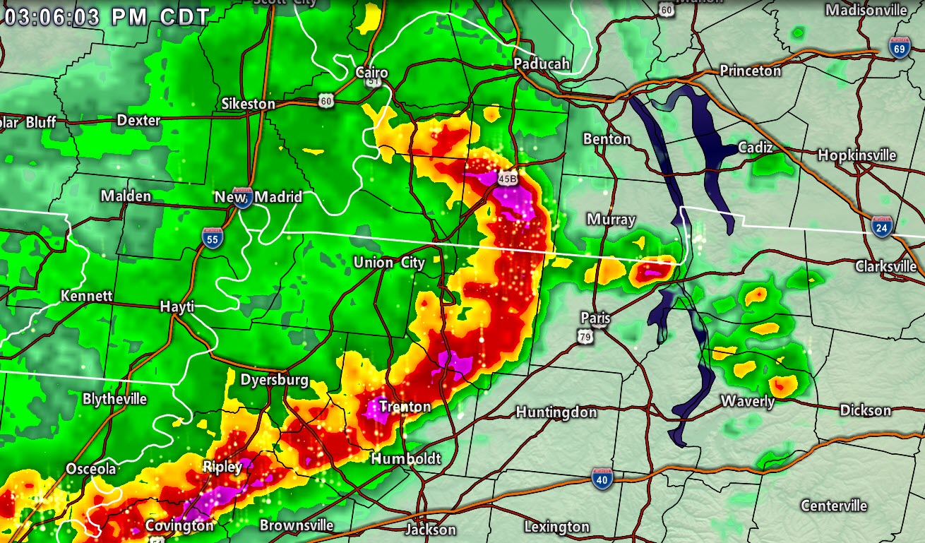
Updated at 3:06 PM
Radar
Radar
https://weatherobservatory.com/radar_paducah.htm
And
https://weatherobservatory.com/radar_dyers.htm
Backup radar page
https://weathertalk.com/morani
Live severe weather feed
https://wtalk.co/R4ZY6ZRM
New “see all” tab on the website. You can view all the messages that I have sent out (to every county)
Link https://weathertalk.com/app/messages
Updated at 3:05 PM
Northern Marshall and northern Lyon County update. The highest wind should stay to your south. Your area can expect showers and thunderstorms. Gusty wind is possible. Lightning.
The wind damage, however, should remain to your south. Stay alert as the storms move through.
Southern Marshall and southern Lyon County may experience high wind. The heavier portion of the storm will impact your area.
Those on the lake should seek shelter.
.
Updated at 3:01 PM
Graves, Calloway, Weakley, and Henry Counties. The southern Graves County rotation has weakened. A new area of rotation was noted near Cottage Grove, TN. The movement of the entire line of storms is east at 60 mph.
Murray will be impacted by the line of storms.
This line of storms has occasionally produced short-lived tornadoes. Let’s treat the line as if it were a tornado warning. Be prepared to seek shelter.
Wind damage has been reported with these thunderstorms. Winds of 60 to 70 mph are likely with these storms. Pockets of high wind.
.
Updated at 2:53 PM
Graves County KY Mesonet station just had a 64.4mph gust at 2:50 pm CDT
Damage in Fulton County: Tree on car, wires down
Tree down, Parkway Mile Marker 11 southbound lane, blocking one lane. Pea size hail in Wingo
.
Updated at 2:49 PM
Southern Graves County, northern Weakley County, Calloway, and Henry Counties. Radar shows a possible tornado over far SW Graves County. It is riding the county border between Graves and Weakley Counties.
The storm is moving east at 60 mph. Calloway and Henry Counties be alert, as well. A tornado is possible with this storm.
.
Updated at 2:47 PM
Tornado Warning [tornado: RADAR INDICATED, hail: <.75 IN] for Graves [KY] till 3:00 PM CDT …AT 245 PM CDT, A SEVERE THUNDERSTORM CAPABLE OF PRODUCING A TORNADO WAS LOCATED NEAR LATHAM, OR 7 MILES EAST OF FULTON, MOVING EAST AT 65 MPH.
.
Updated at 2:45 PM
Carlisle, Hickman, and Graves Counties. Radar shows the area of rotation has weakened. Often times, lines of thunderstorms like this one produce brief tornadoes. They are short-lived and hard to warn on.
Even though the rotation has weakened, you should be alert for rapidly changing weather conditions.
Seek shelter until these thunderstorms pass.
.
Updated at 2:42 PM
2:40 PM Graves, Marshall, and Calloway Counties. Be alert. A line of severe storms is approaching from the west. The line is moving east at 60 mph.
The line has a history of widespread tree damage. Some damage to homes, as well. Brief tornadoes are possible with this line.
Be prepared to seek shelter until these storms pass your area.
Those at LBL should seek shelter. Lyon and Trigg Counties, be alert as these storms approach.
Radar
https://weatherobservatory.com/radar_paducah.htm
And
https://weatherobservatory.com/radar_dyers.htm
Backup radar page
https://weathertalk.com/morani
Live severe weather feed
https://wtalk.co/R4ZY6ZRM
New “see all” tab on the website. You can view all the messages that I have sent out (to every county)
Link https://weathertalk.com/app/messages
.
Updated at 2:37 PM
Obion, Weakley, and Henry Counties. Line of severe storms approaching and moving through your area.
Storms are moving east at 60 mph. They are producing 60 to 70 mph wind gusts. Numerous reports of wind damage have been received from areas to your west.
Brief tornadoes are possible. Seek shelter until these thunderstorms pass your area.
Radar
https://weatherobservatory.com/radar_dyers.htm
Live severe weather feed
https://wtalk.co/R4ZY6ZRM
New “see all” tab on the website. You can view all the messages that I have sent out (to every county)
Link https://weathertalk.com/app/messages
.
Updated at 2:31 PM
Local Storm Report by NWS PAH: Marston [New Madrid Co, MO] trained spotter reports TSTM WND DMG at 01:58 PM CDT — roof damage the city hall building. homes with roof damage. several trees and power lines down. possible tornado. time estimated.
.
Updated at 2:30 PM
Alexander and Pulaski. The worst of the storm has passed to your south. You may still have some gusty wind, lightning, and rain. The severe weather risk has ended for your county.
.
Updated at 2:27 PM
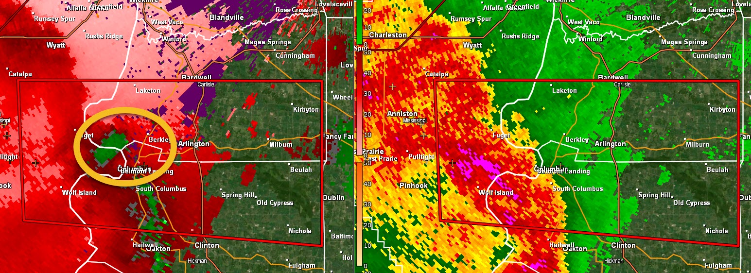
Tornado update. Carlisle and Hickman Counties. Radar shows a possible tornado crossing the Mississippi River near Barkley, Arlington, and South Columbus, KY. Movement is east at 60+ mph. Seek shelter until this storm passes.
Graves County be alert, as well. This storm is to your west and moving east.
I circled the rotation
.
Updated at 2:23 PM
2:24 PM Tornado Warning [tornado: RADAR INDICATED, hail: <.75 IN] for Carlisle, Hickman [KY] and Mississippi [MO] till 2:45 PM CDT …AT 222 PM CDT, A SEVERE THUNDERSTORM CAPABLE OF PRODUCING A TORNADO WAS LOCATED NEAR ANNISTON, OR NEAR TOWOSAHGY STATE HISTORIC SITE, MOVING EAST AT 60 MPH.
.
Updated at 2:22 PM
New Madrid, Dunklin, Pemiscot, Lake, and Obion Counties. Wind damage has been reported in the Missouri Bootheel with wind gusts of 60 to 70 mph. Trees have been reported down and some roof damage.
These storms continue to move east at 60 mph. They are moving fast.
The storms will continue to produce pockets of hail and damaging wind. There is a low-end tornado risk. Seek shelter until the storm’s end.
Radar
https://weatherobservatory.com/radar_dyers.htm
Live stream https://wtalk.co/R4ZY6ZRM
Our new “SEE ALL” page on the Weather Talk website. You can see all the warnings that I post. All of my severe weather messages for every county in the area.
Link https://weathertalk.com/app/messages
.
Updated at 2:21 PM
Local Storm Report by NWS MEG: Caruthersville [Pemiscot Co, MO] trained spotter reports TSTM WND GST of M65 MPH at 02:10 PM CDT –
Local Storm Report by NWS MEG: Holcomb [Dunklin Co, MO] trained spotter reports TSTM WND DMG at 02:10 PM CDT — 3 miles se of holcomb roof damage and trees down.
Updated at 2:20 PM
The line has weakened a little bit over the last 15 minutes. It is still severe and still producing damage. Wind has come down 5 to 10 mph.
Local Storm Report by NWS PAH: 3 NE Hendrickson [Wayne Co, MO] emergency mngr reports TSTM WND DMG at 01:18 PM CDT — tree down on a camper on highway 172 east of us 67. time estimated.
.
Updated at 2:19 PM
Ballard and McCracken. The highest wind should stay south of your counties. There may still be strong and gusty winds with the line.
The apex of the line will move to your south and that is where the greatest risk of wind damage will be placed.
Monitor the radars.
https://weatherobservatory.com/radar_paducah.htm
.
Updated at 2:15 PM
Butler County, Missouri damage. Many reports of trees and power lines down throughout the entire area Crews responding to a tree on a camper on route 172 hwy East of US 67 with a person possibly trapped inside,
This is the path of the highest wind
Updated at 2:12 PM
Many reports of trees and power lines down throughout the entire area Crews responding to a tree on a camper on route 172 hwy East of US 67 with person possibly trapped inside,
.
Updated at 2:11 PM
McCracken, Graves, Marshall, Calloway, Weakley, and Henry Counties. A line of severe thunderstorms is approaching from southeast Missouri.
These storms have produced widespread wind damage. Winds above 70 mph have been reported. Isolated tornadoes, as well.
These storms are moving east at 60 mph.
Be weather aware and prepared to seek shelter from these thunderstorms as they move through the area.
Radars https://weatherobservatory.com/radar_paducah.htm
Live feed https://wtalk.co/R4ZY6ZRM
The live feed has numerous posts.
.
Updated at 2:04 PM
Alexander and Pulaski County. A line of thunderstorms is approaching from the west. The peak of the highest winds may stay south of your counties.
There is a chance it will clip the southern half of the county. The main concern will be wind gusts to 60 mph.
Be alert over the next hour.
Radar https://weatherobservatory.com/radar_paducah.htm
.
Updated at 2:03 PM
Local Storm Report by NWS PAH: 2 S Brownwood [Stoddard Co, MO] law enforcement reports TSTM WND DMG at 01:45 PM CDT — car flipped several times by high winds. possibly tornado. time estimated by radar.
.
Updated at 2 PM
Local Storm Report by NWS PAH: 3 NE Hendrickson [Wayne Co, MO] public reports TSTM WND DMG at 01:15 PM CDT — report from mping: trees uprooted or snapped; roof blown off.
.
Updated at 1:59 PM
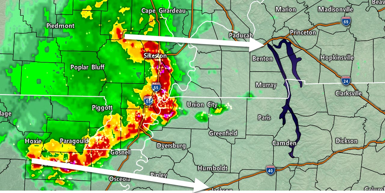
1:59 PM Radar shows the highest wind about to move out of Stoddard County. The highest wind will soon enter Scott, Mississippi, and New Madrid Counties. Pockets of 65 to 75 mph winds are possible. Isolated tornado risk, as well. Torrential rain.
Ballard, Carlisle, Hickman, and Fulton Counties. Be prepared for these storms to enter your counties shortly, as well. They are moving east at 60 mph and have a history of producing tree and home damage.
Radar
https://weatherobservatory.com/radar_paducah.htm
Our new “SEE ALL” page on the Weather Talk website. You can see all the warnings that I post. All of my severe weather messages for every county in the area.
Link https://weathertalk.com/app/messages
.
Updated at 1:51 PM
Storm line is moving east at 60 mph. Widespread high winds with it.
Local Storm Report by NWS PAH: 1 E Poplar Bluff [Butler Co, MO] emergency mngr reports TSTM WND DMG at 01:18 PM CDT — tree down on a house with residents trapped inside.
.
Updated at 1:49 PM
Local Storm Report by NWS PAH: 1 W Dexter [Stoddard Co, MO] trained spotter reports TSTM WND DMG at 01:39 PM CDT — snapped trees in dexter.
117 West Center Street in Poplar Bluff, Missouri, tree on a home with residents trapped
.
Updated at 1:45 PM
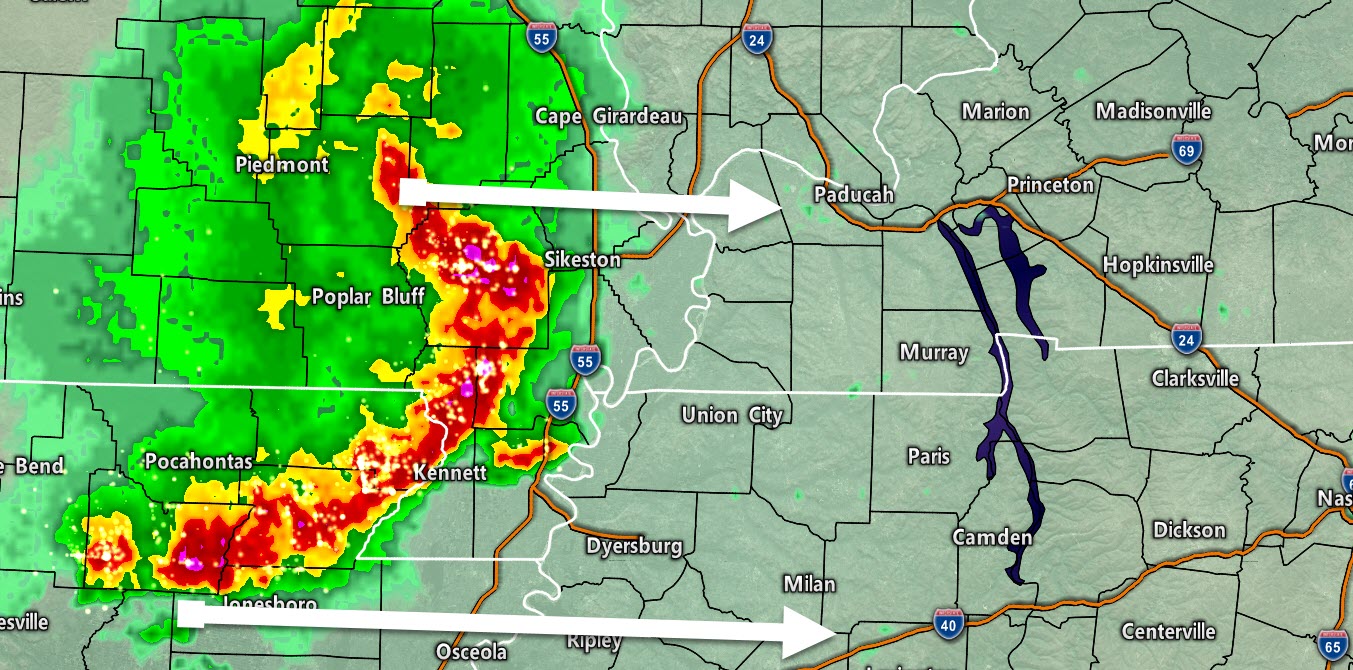
1:44 PM Stoddard, Scott, Mississippi, Dunklin, New Madrid, and Pemiscot Counties. Far west KY and NW TN. There are widespread reports of trees down and roof damage from these thunderstorms.
The most intense thunderstorms were located in Stoddard County and northern Dunklin County. These storms are moving rapidly eastward at 60 mph.
Winds over 70 mph are possible with these thunderstorms. Isolated tornadoes may also occur with little or no warning.
Seek shelter as these thunderstorms approach and pass your location.
West Kentucky and northwest Tennessee be alert. They will enter your area after they move out of southeast Missouri.
Radar
https://weatherobservatory.com/radar_paducah.htm
Our new “SEE ALL” page on the Weather Talk website. You can see all the warnings that I post. All of my severe weather messages for every county in the area.
Link https://weathertalk.com/app/messages
.
Updated at 1:42 PM
Local Storm Report by NWS PAH: 4 SW Dexter [Stoddard Co, MO] trained spotter reports TSTM WND DMG at 01:35 PM CDT — one foot diameter tree split by high winds.
.
Updated at 1:39 PM
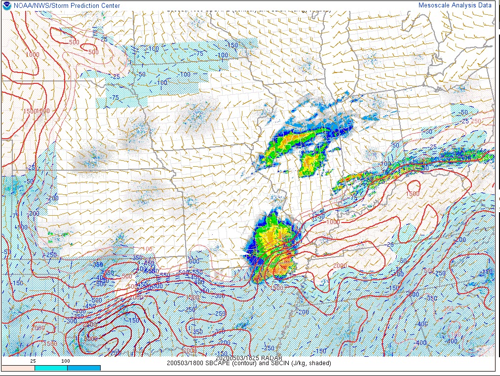
CAPE map. CAPE is the energy that storms can tap into. The CAP has eroded and that means these thunderstorms will be able to tap into surface based CAPE.
The risk of severe weather continuing is high.
CAPE is represented by those red lines. CAPE values of 1000+ are being indicated.
.
Updated at 1:35 PM
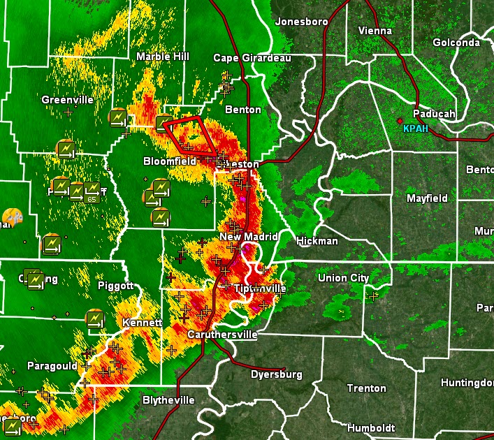
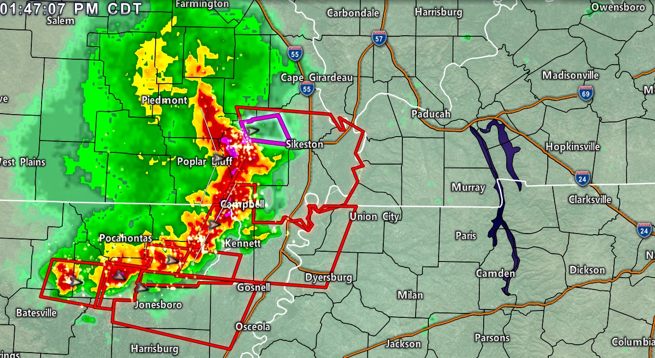
PAH issues Tornado Warning [tornado: RADAR INDICATED, hail: <.75 IN] for Stoddard [MO] till 2:15 PM CDT …AT 134 PM CDT, A SEVERE THUNDERSTORM CAPABLE OF PRODUCING A TORNADO WAS LOCATED NEAR PUXICO, OR 10 MILES NORTHWEST OF BLOOMFIELD, MOVING EAST AT 60 MPH.
Updated at 1:33 PM
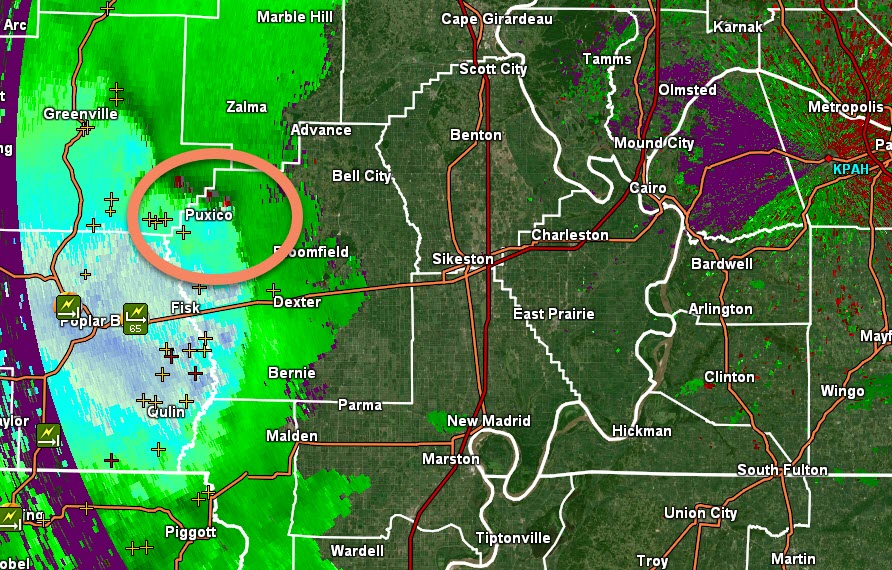
Stoddard County. Scott and New Madrid should monitor, as well. Radar shows rotation over far northwest Stoddard County. This storm could produce brief tornadoes. Be weather aware as the storms move east at 50 to 60 mph.
Radar http://weatherobservatory.com/weather-radar.htm
I circled the area of concern. Movement is east.
Updated at 1:31 PM
Local Storm Report by NWS PAH: 9 W Grandin [Ripley Co, MO] public reports TSTM WND DMG at 12:45 PM CDT — 3 large trees uprooted. gust to 52mph measured with ambient weather ws.
Updated at 1:30 PM
Local Storm Report by NWS PAH: 5 E Poplar Bluff [Butler Co, MO] asos reports TSTM WND GST of M66 MPH at 01:19 PM CDT —
Updated at 1:30 PM
1:30 PM Mississippi County in Missouri. Ballard, Carlisle, Hickman, and Fulton Counties in western Kentucky, Lake and Obion Counties in western Tennessee.
A line of severe thunderstorms is approaching from southeast Missouri. The line is moving east at 50 to 60 mph. The line has a history of wind damage.
At this time, it appears the line could produce wind gusts of 60 to 70 mph.
Be prepared to seek shelter as these storms approaching. You still have a little bit of time before they arrive.
Video update https://youtu.be/L0pspbj0x1o
.
Updated at 1:25 PM
Damage reports now from Neelyville Mo. Roof taken off of a porch and siding off of a home. Numerous trees down.
Reports of tree damage in Doniphan, MO.
Updated at 1:10 PM
Bollinger, Cape Girardeau, Scott, Stoddard, Dunklin, New Madrid, and Pemiscot Counties in southeast Missouri.
A line of thunderstorms is approaching from the west. The line is moving east at 55 to 60 mph.
This line of thunderstorms has a history of producing quarter size hail and 60 mph wind gusts.
Be weather aware over the coming one to two hours as this line approaches. Some sporadic wind damage is likely. A few reports of hail.
There is a low-end tornado risk.
NOTE: Bollinger and Cape Girardeau Counties. The heaviest part of the storms may stay just to your south or clip the southern quarter of the counties.
The highest wind gusts should be just south of your counties. I will continue to monitor the track. It is moving east and slightly southeast.
That would place the higher wind just south of your counties. Monitor.
Storm tracking links.
Interactive city-view radars
http://weatherobservatory.com/weather-radar.htm
A third backup radar
https://weathertalk.com/morani
Clickable watches and warnings can be viewed on the local city-view interactive radars (link above). Be sure and turn on the warnings above the local radars.
A new regional radar we offer
https://imagery.weathertalk.com/prx/RadarLoop.mp4
Lightning data
https://wtalk.co/7QT7WHKU
.
Updated at 12:56 PM
Time-sensitive radar loop. To view live radars go to these links
Interactive city-view radars
http://weatherobservatory.com/weather-radar.htm
A third backup radar
https://weathertalk.com/morani
Clickable watches and warnings can be viewed on the local city-view interactive radars (link above). Be sure and turn on the warnings above the local radars.
A new regional radar we offer
https://imagery.weathertalk.com/prx/RadarLoop.mp4
Lightning data
https://wtalk.co/7QT7WHKU
.
Updated at 12:50
Updated at 12:50 PM
Butler County, MO. A line of storms is approaching from the west. This line could produce high wind and hail.
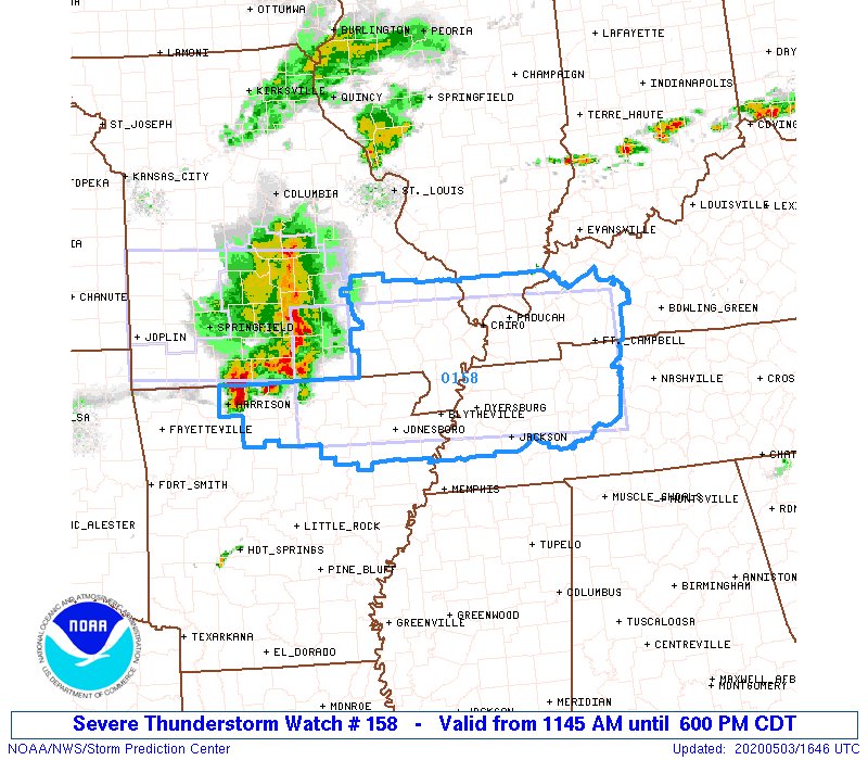
Updated at 11:50 am
Severe thunderstorm watch.
<nwsbot> PAH issues Severe Thunderstorm Watch for Bollinger, Butler, Cape Girardeau, Carter, Mississippi, New Madrid, Ripley, Scott, Stoddard, Wayne [MO] and Ballard, Caldwell, Calloway, Carlisle, Christian, Crittenden, Fulton, Graves, Hickman, Hopkins, Livingston, Lyon, Marshall, McCracken, Muhlenberg, Todd, Trigg [KY] and Alexander, Hardin, Johnson, Massac, Pope, Pulaski, Union [IL] till 6:00 PM
Updated at 10:40 AM Sunday
A complex forecast is unfolding. That is not a surprise. Confidence in this event has been lower than normal. Mainly because guidance has been all over the place with the details. Guidance = models.
We do depend on guidance to help put together a forecast. That is not the end-all. It is just one piece of the puzzle.
Today’s forecast will be based on surface maps and current satellite/radar trends.
Northern portions of the region may receive little or no rain today. They may have to wait until tomorrow’s event.
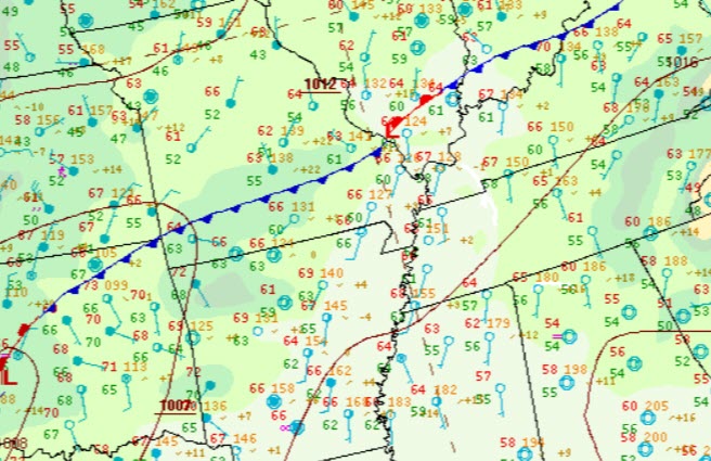
Here is the 10 AM location of the cold front.
The front will slowly sag southward today. It will then stall. It will move back north on Monday morning/afternoon.
.
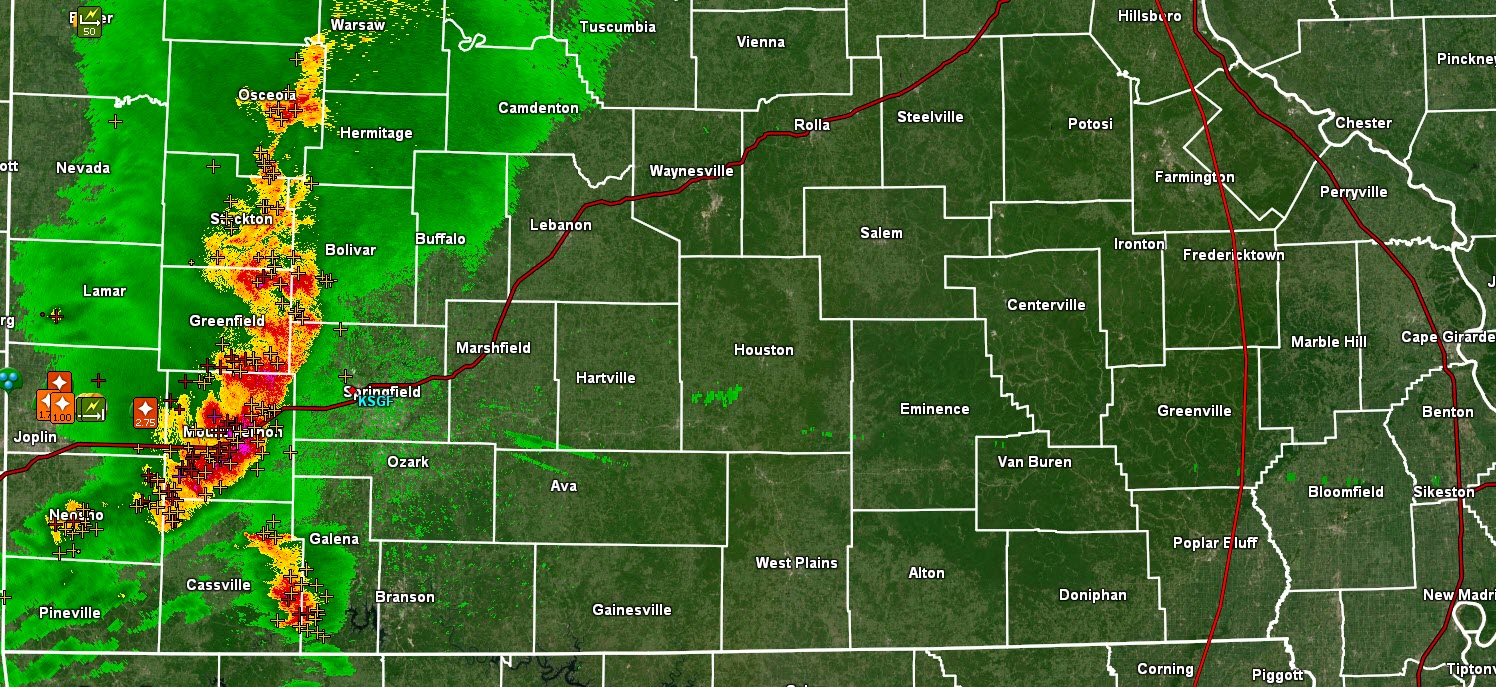
DATED radar loop. This is not the current loop. See the live radars for a current radar loop.
You can see the thunderstorm complex pushing across southwest Missouri.
Interactive city-view radars
http://weatherobservatory.com/weather-radar.htm
A third backup radar
https://weathertalk.com/morani
Clickable watches and warnings can be viewed on the local city-view interactive radars (link above). Be sure and turn on the warnings above the local radars.
A new regional radar we offer
https://imagery.weathertalk.com/prx/RadarLoop.mp4
Lightning data
https://wtalk.co/7QT7WHKU
.
A severe thunderstorm watch has been issued for portions of southern Missouri. I can’t rule out additional watches further east.
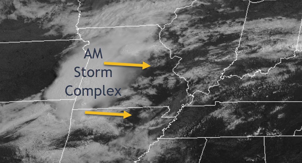
A complex of severe thunderstorms has developed ahead of a cold front over southwest Missouri. These thunderstorms are moving east along a boundary.
The storms have a history of producing hail and wind damage.
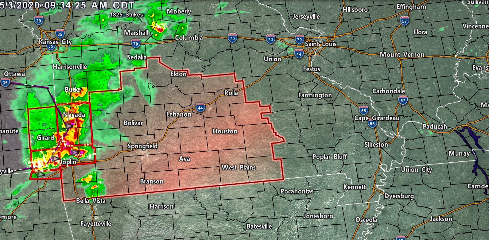
Another 10 AM radar shot. Storms are moving east and will eventually turn east/southeast.
Here are two satellite views of the thunderstorms.
.
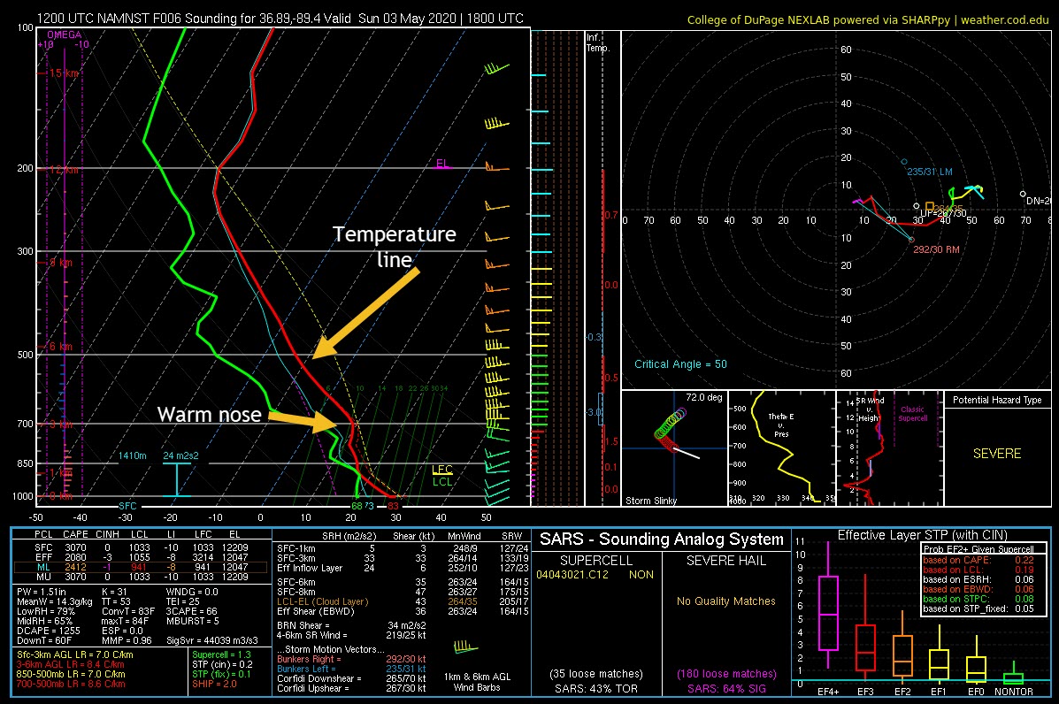
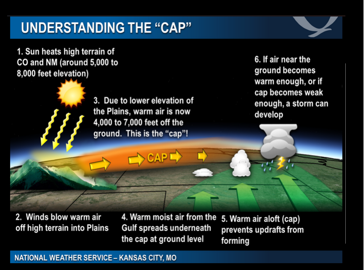
There is a warm layer of air aloft draped across our region. We call this a CAP. A CAP is a warm layer of air, several thousand feet aloft, that keeps thunderstorms from forming and/or keeps them from becoming surface-based.
Here is a sounding. Soundings are a slice of the atmosphere at a given time and point. In other words, you are looking at what is happening from the ground upward. The warm nose of air is around 700 MB. Several thousand feet aloft.
.
The CAP may erode some this afternoon and evening. What does that mean? It means the warm nose would disappear. That would introduce a greater chance of surface-based thunderstorms. The severe weather risk would be greater.
.
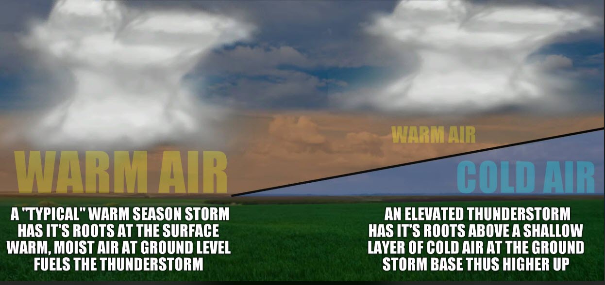
What does surface-based mean? There are two types of thunderstorms. Surface-based and elevated.
Elevated storms occur above the warm layer of air. These oftentimes remain below severe levels or produce hail and occasionally downburst wind damage.
Surface-based storms are more severe. Those are the ones that can produce tornadoes and widespread wind damage. Each event is unique, of course.
Today, it appears some of the storms will be elevated. Whether they can become surface-based is questionable. It is something that I am monitoring closely.
I found this graphic online. It does not have to be “cold” at the surface for elevated storms. It simply means it is cooler than the air higher up in the atmosphere. The word cold, in this case, is subjective.
.
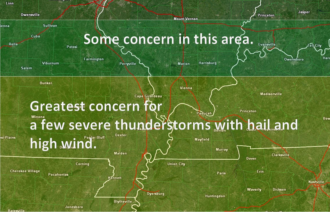
Here is my current forecast for the area of greatest concern. Storms will be moving east/southeast.
The time-frame of concern for southeast Missouri will be 12 PM to 3 PM.
The time-frame for southern Illinois, western Kentucky, and western Tennessee, will be from 1 PM to 5 PM.
Keep in mind, thunderstorms may linger past 5 pm along the stalled front. That would most likely be across extreme southern Missouri, the Bootheel of Missouri, and along the Kentucky/Tennessee border southward. Counties along the border.
.
Let me show you some future-cast radars. Keep in mind, model guidance does not all agree on the exact placement or intensity of the line of thunderstorms later today.
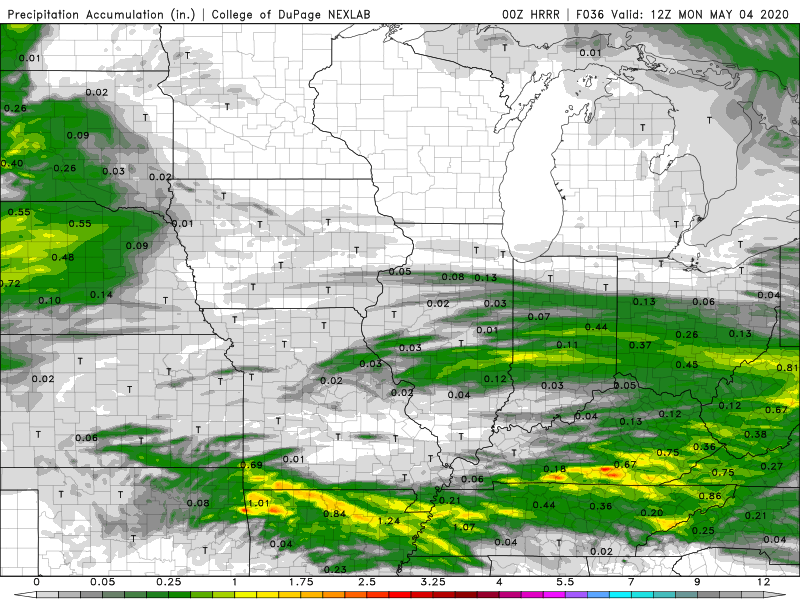
Hrrr model.
.
SPC WRF model
.
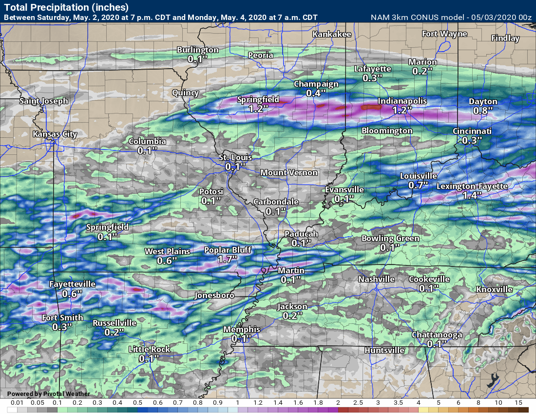
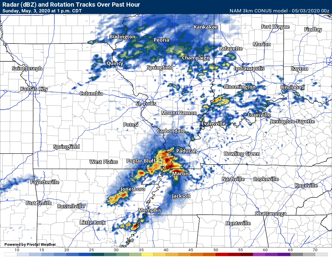
NAM 3K model
.
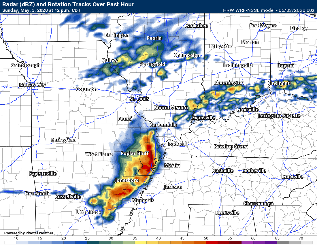
HRW WRF-ARW model.
.
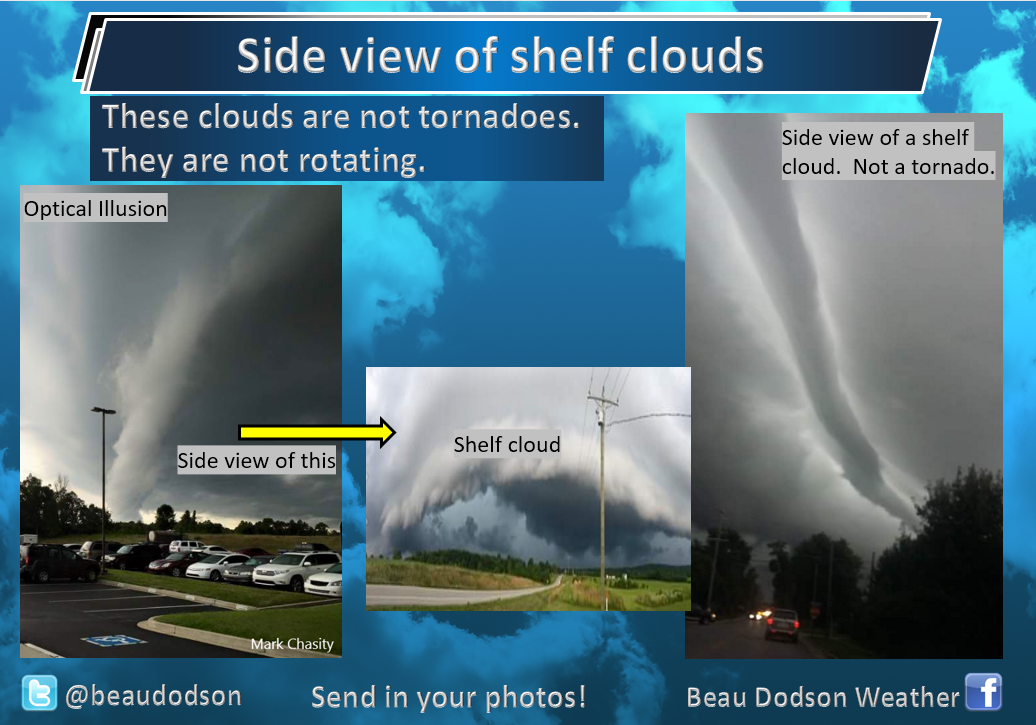
You may see a shelf cloud today. This can be quite beautiful and also a bit scary. Shelf clouds form because of rain cooler air pushing ahead of a line of thunderstorms.
The shelf cloud itself does not mean that a thunderstorm is severe. Sometimes, shelf clouds bring little or no severe weather. Just rain behind the leading edge. Other times, shelf clouds can mean damaging wind and hail. Each thunderstorm is unique.
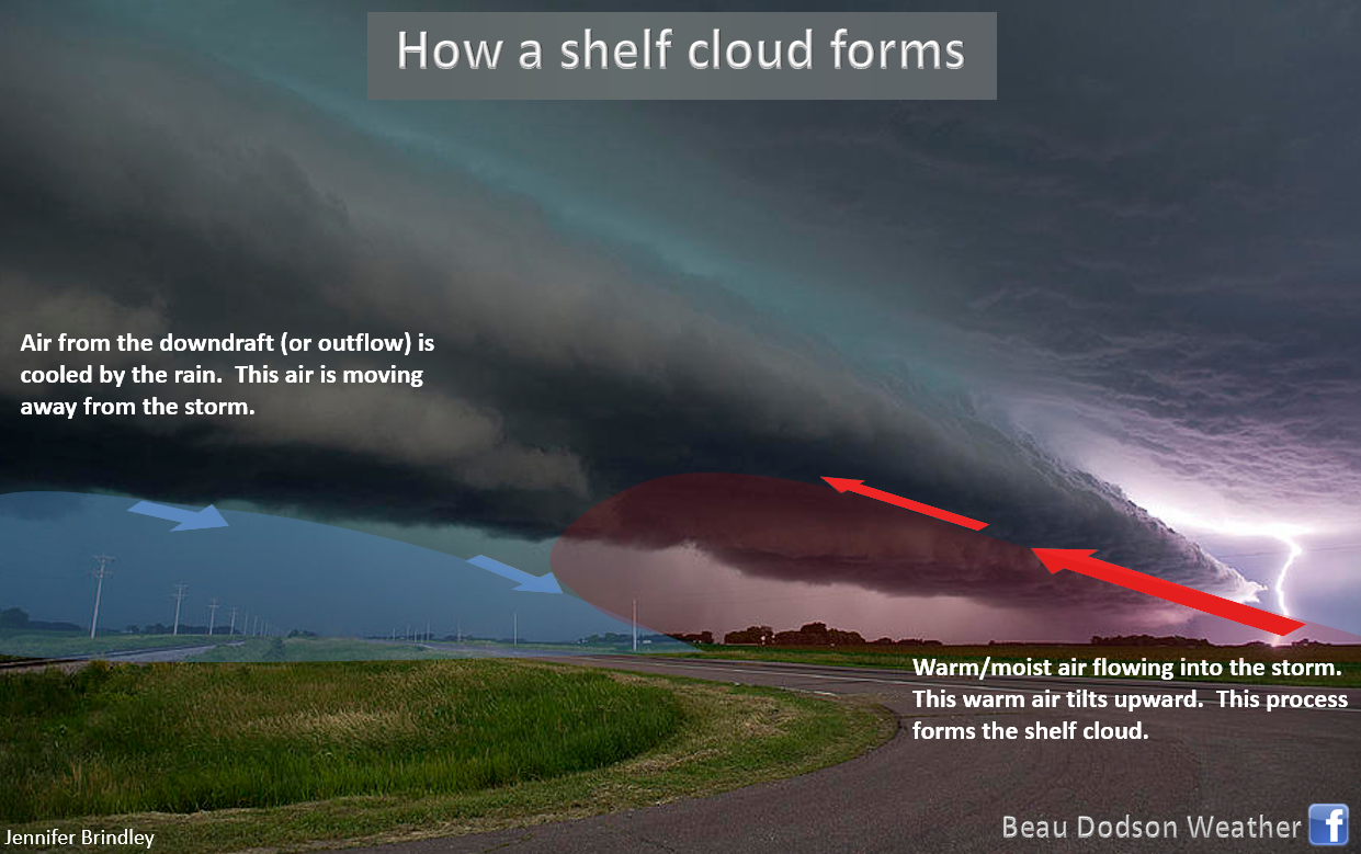
The side view of a shelf cloud can appear to be a tornado. It isn’t. you are simply looking at the leading edge of the line of thunderstorms.
.
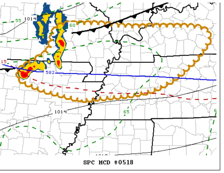
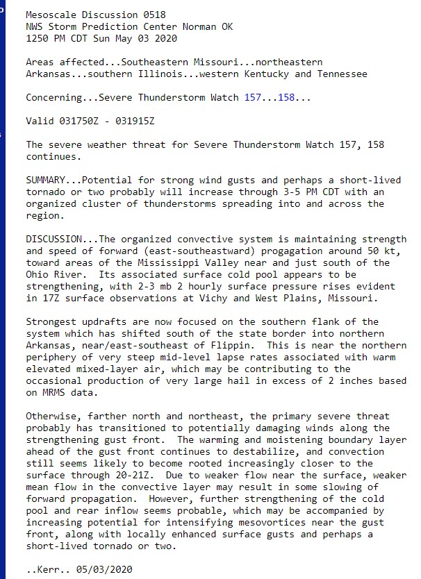
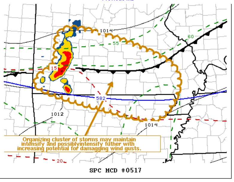
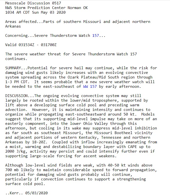
Storm Prediction Center update.
.
We also have a risk of severe weather Monday afternoon and night.
This will occur as the front moves back north and a disturbance rides along the front.
Models show widespread showers and thunderstorms diving E/SE through Missouri and Illinois and then across Kentucky/Tennessee.
Damaging wind and hail will once again be a possibility. Locally heavy rain is likely, as well.
Future-cast radar.
.
.
Updated at 10 PM Saturday
Well, confidence in how Sunday plays out is not exactly all that high. Confidence is low.
Model guidance is all over the place with placement and coverage of thunderstorms.
My going forecast is that the greatest thunderstorm coverage will end up being across southern Missouri into Kentucky and Tennessee.
That will occur as the front sags southward.
Areas to the north will have shower and thunderstorm chances, as well. The coverage, however, should be greater the further south you travel.
Some of the thunderstorms could produce high wind and hail. There is a low-end severe weather threat. I would not be surprised to see a couple of severe thunderstorm warnings.
Here are some maps.
This is the Hrrr high-resolution model guidance. Look at how much of the area it keeps dry through Monday morning. Most of the area will miss out on the rain (if the Hrrr is correct).
One model of many. It is just an example, however, of what I am having to try and forecast.
Here is the NAM model. Notice, again, the southern section of the region receives the most rainfall.
.
This is the SPC WRF model. It brings a band of thunderstorms across southern Missouri and pushes it east into part of Kentucky and Tennessee. That has the look of gusty winds.
This is the NAM model. It is not too far off from what the above model is showing.
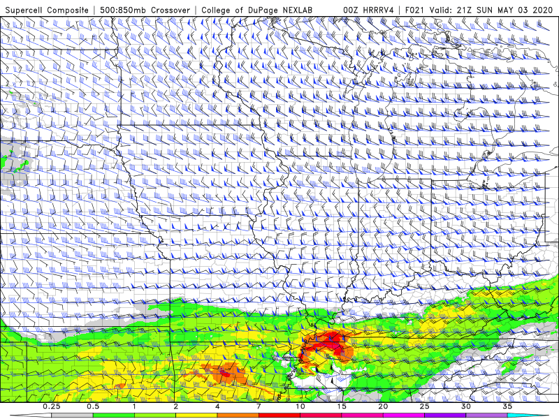
Here is the supercell composite index. What is this? It shows you were intense thunderstorms could occur. At least where the parameters are present for strong thunderstorms.
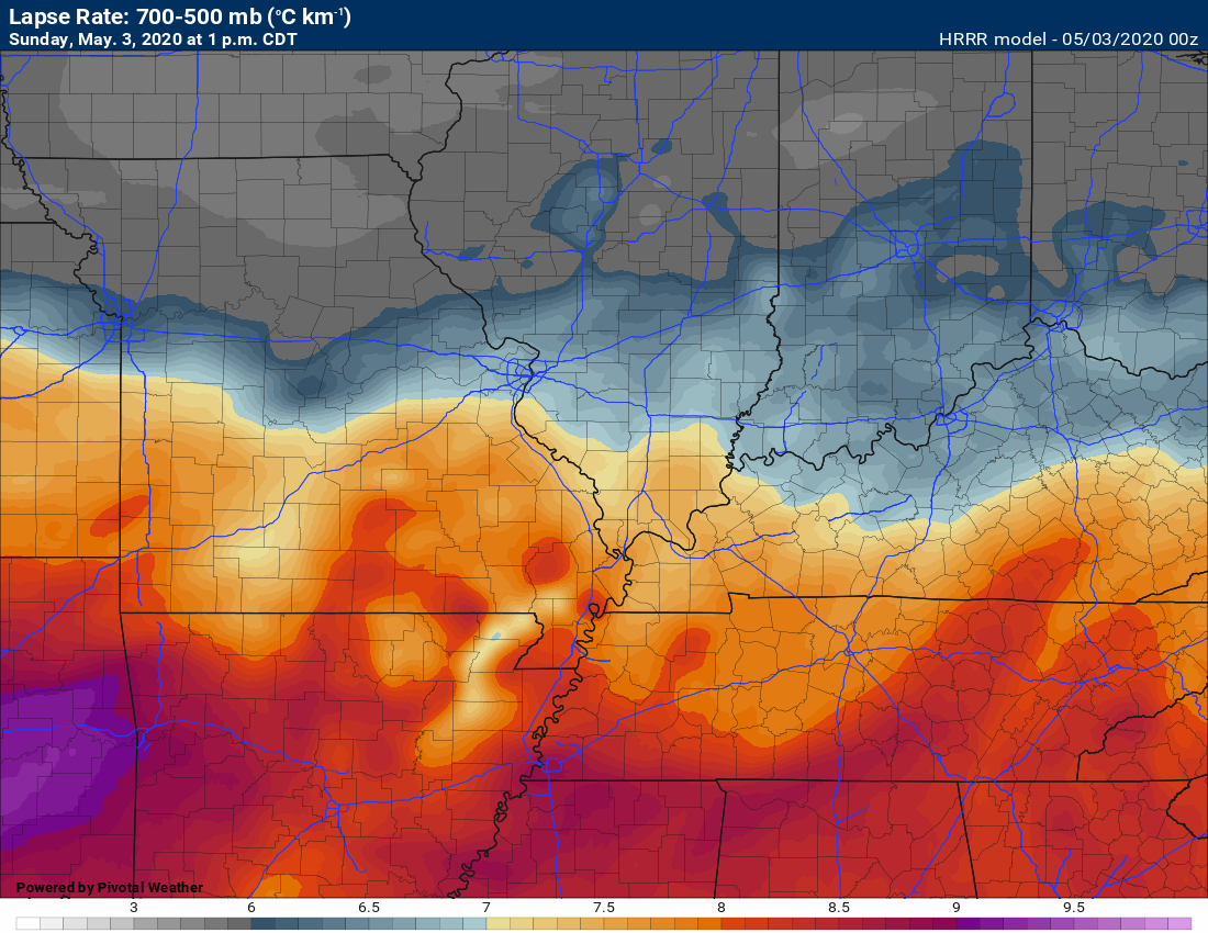
This is the lapse rate chart for tomorrow afternoon. These are decent lapse rates. Lapse rates show you how fast the air cools as you move aloft. Higher lapse rates are an indicator of an unstable atmosphere (under certain conditions).
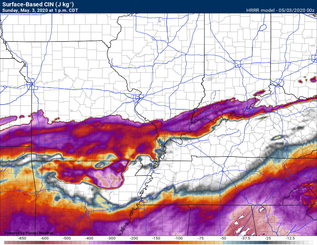
Here is the surface-based CIN. This shows you the CAP. What is a CAP. A CAP is a warm layer of air aloft. It can prevent surface-based thunderstorms from forming.
Thunderstorms would form in an elevated fashion. Elevated storms typically produce hail and sometimes gusty winds. The surface-based storms are the ones that usually produce the greater severe weather threat.
Here is the CAPE chart. Remember CAPE is the energy that thunderstorms can tap into.
Do you notice anything about these maps? They all focus on the southern half of the region.
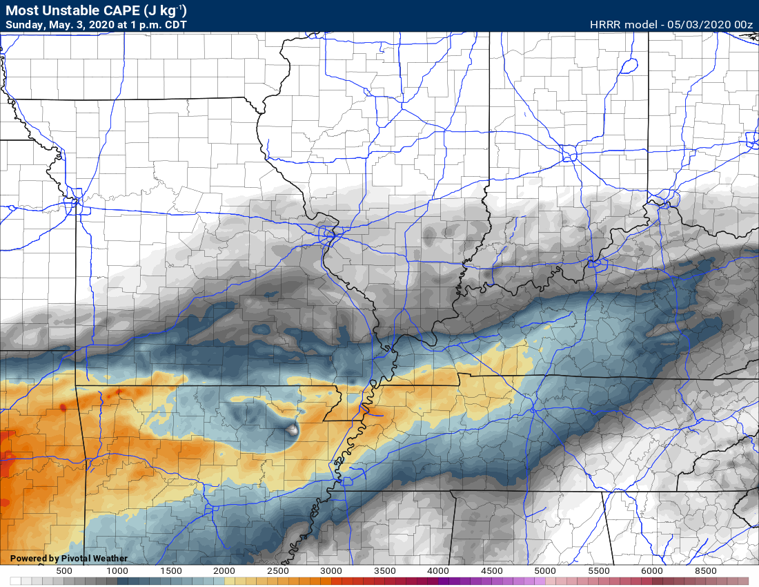
I will be monitoring the entire area tomorrow. My main concern will be southern Missouri into Kentucky and Tennessee.
Areas to the north will need to monitor, as well.
Updated at 11 AM
The main concern will be late tonight into Sunday.
This is a marginal set-up for severe thunderstorms. There is a layer of warm air aloft and that is called a CAP. The CAP helps prevent widespread severe thunderstorms.
The front is weak. The forcing/lift along the front is weak.
Multiple models, however, do show the development of showers and thunderstorms late tonight into Sunday.
Several models show a line of thunderstorms moving west and east across the region. With time, the storms will be shifting southward, as well.
Some of the storms could produce strong and gusty wind and even a few reports of hail.
Most of the storms will be elevated. That means above the boundary/surface layer.
Surface-based storms usually have a much higher chance of producing actual severe weather. Elevated storms, above the warm layer, often times produce hail and occasionally gusty wind.
This appears to mostly be an elevated event. It will need to be monitored closely.
There is plenty of CAPE to work with. Remember, CAPE is fuel for thunderstorms to tap into. CAPE is a number that meteorologists monitor when forecasting severe thunderstorms.
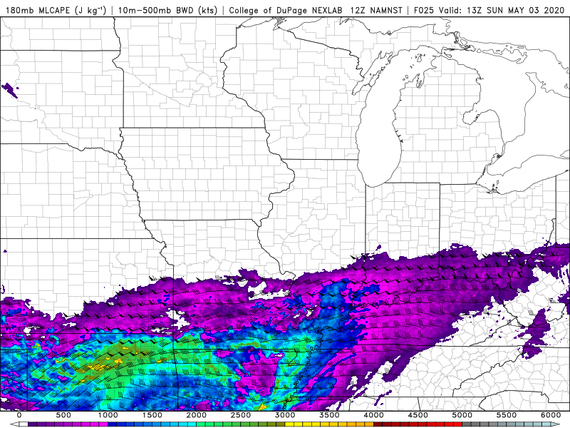
Here is the MLCAPE graphic. There will be elevated CAPE to work with.
8 AM Sunday
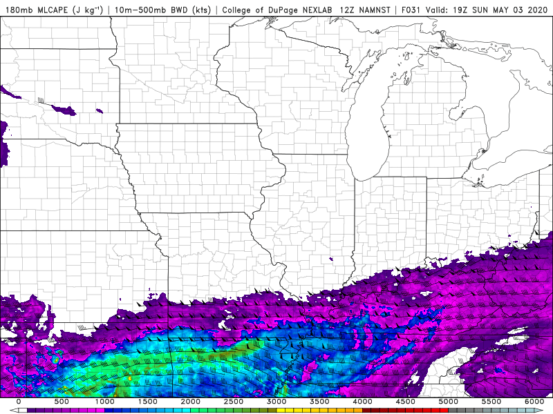
2 PM Sunday
.
Hrrr model future-cast radar
.
NSSL WRF model. Future-cast radar. What radar MIGHT look like late tonight into tomorrow.
.
Radars
Interactive city-view radars
http://weatherobservatory.com/weather-radar.htm
A third backup radar
https://weathertalk.com/morani
Clickable watches and warnings can be viewed on the local city-view interactive radars (link above). Be sure and turn on the warnings above the local radars.
A new regional radar we offer
https://imagery.weathertalk.com/prx/RadarLoop.mp4
Lightning data
https://wtalk.co/7QT7WHKU
.
Storm Prediction Center severe weather outlook.
Here is the latest Storm Prediction Center outlook. Remember, don’t pay too much attention to the different colors. Focus on the actual forecast. The forecast is for a few severe thunderstorms.
The black outline is our local area.
Light green is where thunderstorms may occur but should be below severe levels.
Dark green is a level one risk. Yellow is a level two risk. Orange is a level three (enhanced) risk. Red is a level four (moderate) risk. Pink is a level five (high) risk.
One is the lowest risk. Five is the highest risk.
A severe storm is one that produces 58 mph wind or higher, quarter size hail, and/or a tornado.

.
Tomorrow’s severe weather outlook.

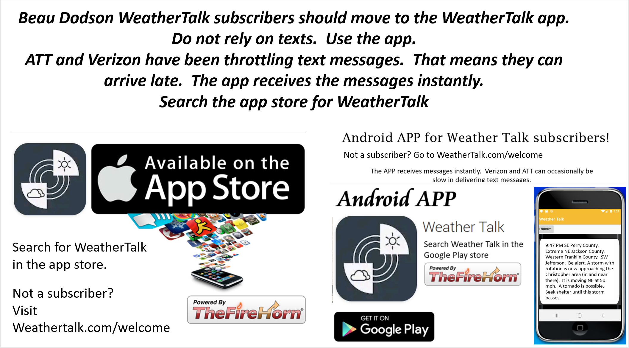
Not receiving app/text messages?
USE THE APP. ATT and Verizon are slowing or stopping the text messages.
Make sure you have the correct app/text options turned on. Find those under the personal notification settings tab at www.weathertalk.com. Red is off. Green is on.
Subscribers, PLEASE USE THE APP. ATT and Verizon are not reliable during severe weather. They are delaying text messages.
The app is under WeatherTalk in the app store.

Apple users click here

Android users click here
.

Live lightning data: Click here.