Afternoon update…
A chance for light snow tonight and tomorrow.
There could be a period of light snow developing later tonight and that will continue into tomorrow morning. Some of the data is showing a dusting to an inch or so of snow. There is quite a bit of dry air to overcome. If snow does develop then it should stick. Ground is cold.
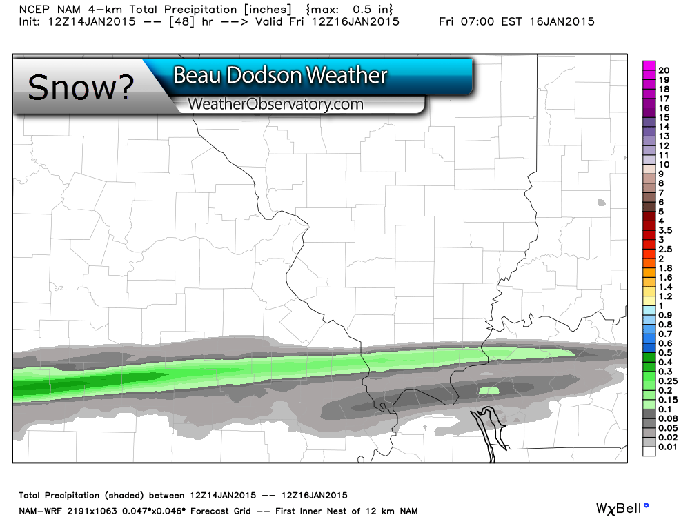
Here is the latest high resolution WRF model for precipitation totals. You can see a streak of precipitation across parts of our area.
Data image from www.weatherbell.com
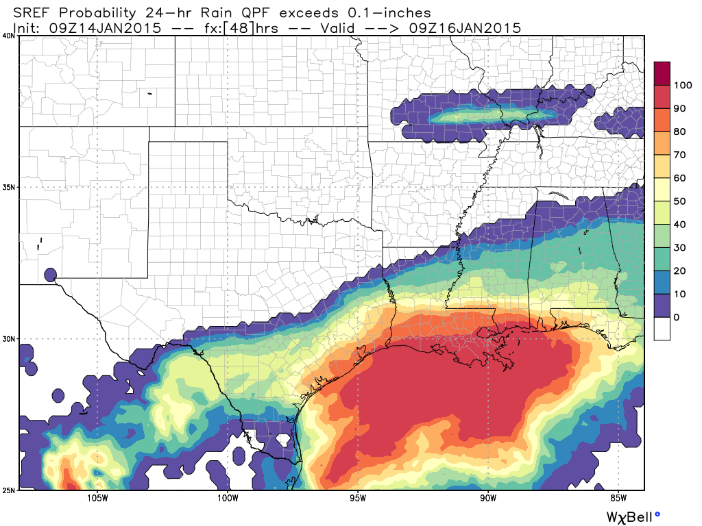
Here is the probability of 0.10″ of precipitation falling (that would be 1″ of snow)
You can see where the highest numbers are located
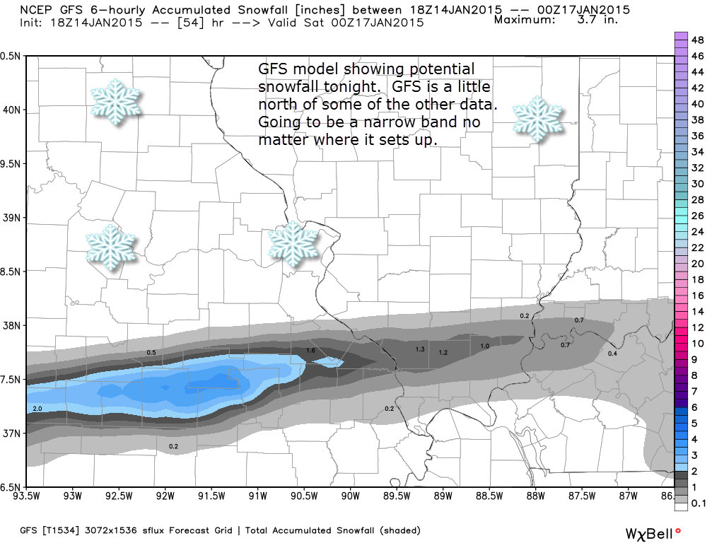
Here is the GFS model from www.weatherbell.com
You can see the GFS streaks the snow and the potential accumulation numbers.
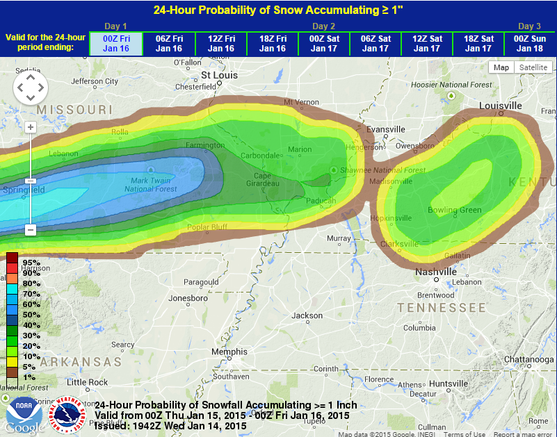
Here is another probability map. This map shows you the probability of 1″ of snow falling tonight and tomorrow morning.
We have our first sponsor for the blog. Milner and Orr Funeral Home and Cremation Services located in Paducah, Kentucky and three other western Kentucky towns – at Milner and Orr they believe in families helping families.

This forecast update covers far southern Illinois, far southeast Missouri, and far western Kentucky. See the coverage map on the right side of the blog.
Wednesday – A mix of sun and clouds. Perhaps more sun than on Tuesday. Small chance for a flurry. It will be chilly, but not too bad for January. High temperatures will be in the upper 20’s. North winds at 5-10 mph.
Morning School Bus Stop Weather – Quite a few clouds and chilly. Temperatures will be in the lower 20’s. North winds at 5 mph.
Afternoon School Bus Stop Weather – Quite a few clouds and chilly. Temperatures will be in the upper 20’s. North winds at 5 mph.
Wednesday night – Some clouds. A chance for some light snow late at night. Chilly. Low temperatures in the upper teens and lower 20’s. North winds at 5 mph.
Thursday – Morning clouds with a chance for a period of light snow. Then clearing sky conditions. Slightly warmer with high temperatures into the 30’s. West winds becoming southwest at 5-10 mph. Total snow accumulation of a dusting to 2″ over the area. Best chance for 1″-2″ will be over far southeast MO into part of southern IL. See maps as I post them today and tonight.
Thursday night – Mostly clear. Not as cold as recent nights. Low temperatures in the 20’s. Southwest winds at 5-10 mph.
Friday – A warming trend. Mostly sunny with temperatures reaching into the pleasant 40’s. South winds at 10 mph.

Current Temperatures Around The Local Area


An explanation of what is happening in the atmosphere over the coming days.

Welcome the Wednesday! Hump-day has arrived and with it comes some good news. We should start to see more sun over the coming days with milder temperatures. Highs by Friday will reach into the 40’s. We MAY even see some near 50 degree temperatures over the weekend (Saturday). Fingers and cold toes crossed. Right? I have a feeling nobody will complain.
But, first we have a weak weather system moving through our region tonight and Thursday morning. We may see a period of light snow associated with this disturbance. There is not a lot of moisture to work with. But, some precipitation may streak across southern Missouri into southern Illinois and western Kentucky. This would likely be very late tonight into tomorrow morning.
There is a lot of dry air at the lower levels of the atmosphere. Usually that means precipitation evaporates before reaching the ground. We will see if some of the snowflakes can make it all the way to the ground. Some light accumulation possible. Dusting to an inch or so. There may be a small band of 1″-2″ over southeast Missouri into part of southern Illinois (see the above maps)
Our next weather system arrives on Saturday night. A cold front will pass through the area.
There will be some increase of moisture late Saturday night into Sunday morning as this system pulls through the area. For now I will keep an eye on it. At the most it might bring an increase in clouds and a light shower.
The front passes through on Saturday night. That does mean Sunday will be slightly cooler than Saturday. Hopefully we can still reach the 40’s. The warmest day will be Saturday – Saturday is when some areas might reach 50 degrees.
January has a chilly month, thus far. Some solid cold snaps, but every January brings cold snaps. We have not had a single significant winter storm. No significant ice. Just the cold. But, again – it is January and January cold is normal.
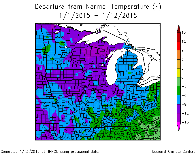
Let’s take a look at the temperature departure map for January, thus far. These negative anomalies are going to go bye bye over the coming weeks. The above normal temperatures will likely mean that January will end up closer to near normal – perhaps a little below normal in the temp department. Right now a large chunk of the U.S. is running below normal for the month to date.
Let me explain what this map is showing you…
This map tells you how many degrees above or below normal temperatures have averaged since January 1st. You can see that most of the map is running below normal. Paducah, KY is running above 5 degrees below normal for the Month of January…thus far. That is an impressive anomaly.
Yellow on the map would indicate temperatures are running near normal. No yellow on this map! No areas of above normal, either.
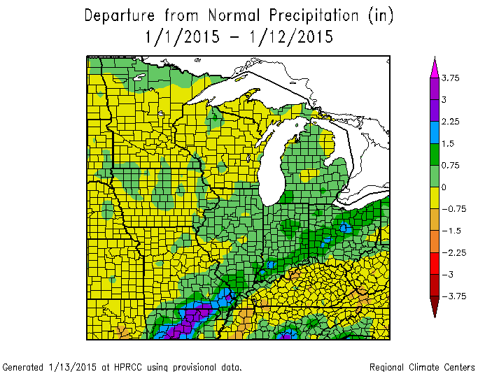
What about precipitation, you may ask. Well, I am glad you asked! This is the month to date precipitation anomalies. You can see portions of our region are running above normal in the precipitation department. Other parts of the area are averaging near normal precipitation. Paducah, Kentucky is running near normal in the precipitation department.
The streak of blue and purple across southern Missouri into southern Illinois was because of the big precipitation event the other week. Some spots picked up more than 4″ of rain from that event.
Much of Kentucky is running below normal in the precipitation department.
My winter forecast was for below normal precipitation and below normal temperatures. We will see how it goes. Still some time to go before we can verify that forecast.
I can’t find any significant winter storms for us to track. There have been on and off signals for a storm system later next week. The models keep losing it and bringing it back. For now it is a wait and see. Either way…the last half of January may end up bringing mostly above normal temperatures. Snow lovers…you will have to wait a bit longer.
How about a beautiful snow photo to start your day?
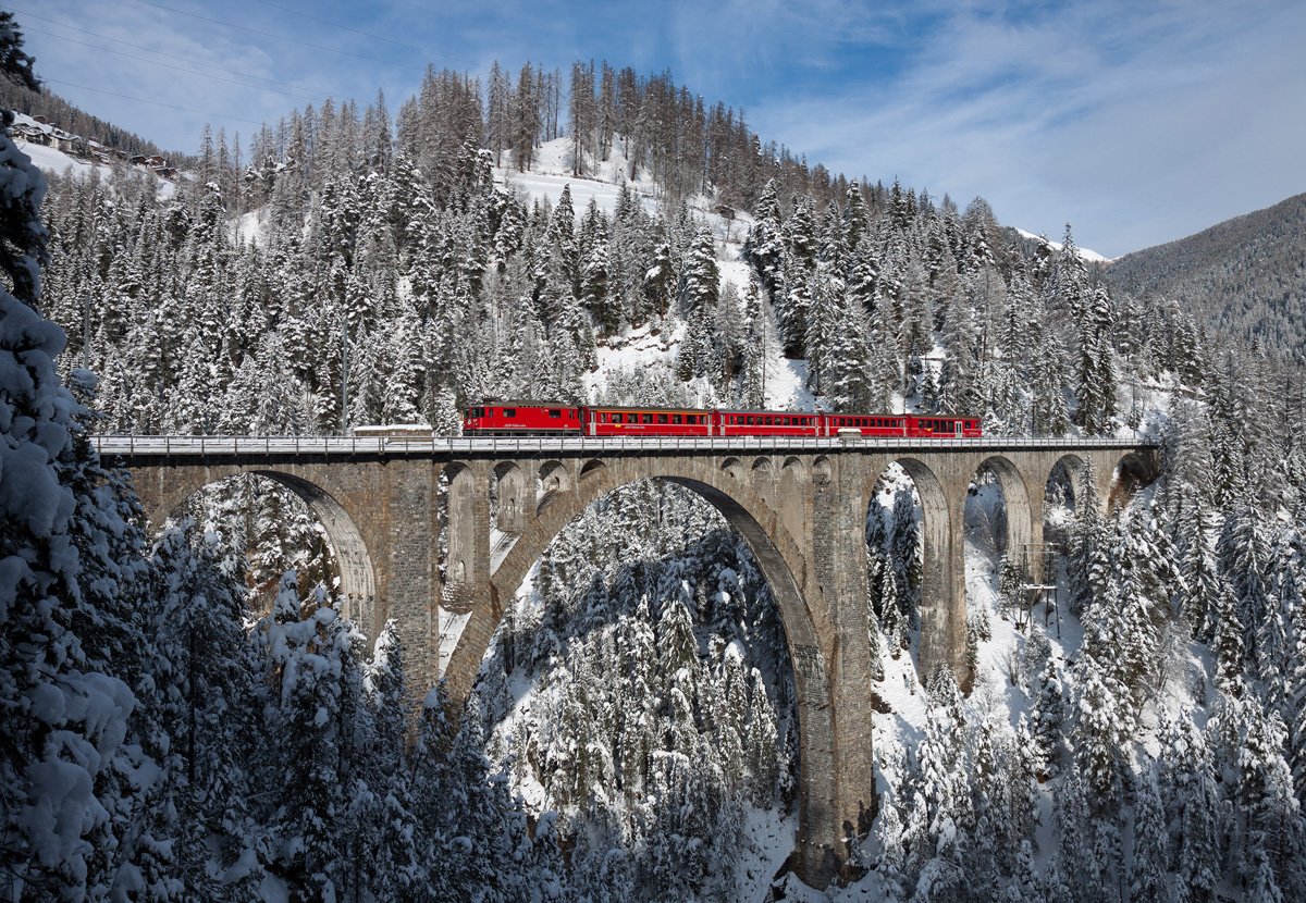
Photograph by Kabelleger / David Gubler
The Wiesen Viaduct is a single track limestone railway viaduct. It spans the Landwasser River southwest of the hamlet of Wiesen, in the Canton of Graubünden, Switzerland.
Designed by the then chief engineer of the Rhaetian Railway, Henning Friedrich, it was built between 1906 and 1909 under the supervision of another engineer, Hans Studer. The Rhaetian Railway still owns and uses it today. The viaduct is 88 metres (289 ft) high, 204 metres (669 ft) long, and has a main span of 55 metres (180 ft), which makes it one of the longest main spans of any masonry bridge.

I did add some light precipitation for late tonight into Thursday morning. Moisture is limited with this system. There could, however, be a period of light snow showers. Lot of dry air for precipitation to fall through. That normally means a lot of evaporation. Precipitation not reaching the ground.
Snowfall accumulation of a dusting to an inch or two possible.
![]()
No major concerns. I did add some light snow showers in the forecast for late tonight and tomorrow morning. We will see if some of the flakes can overcome the dry air aloft and make it all the way to the ground.
If snow does develop then it would accumulate because of the cold roadways.
But, if you are concerned about lunch or dinner, then you might want to check out our newest sponsors $5 meal deal! The DQ Grill and Chill (located across from Noble Park in Paducah, Kentucky) is the newest WeatherTalk Blog sponsor! A local business helping to sponsor the weather information that you have come to love so much.
They also have a Facebook Page and I encourage you to check it out. DQ Grill and Chill on Facebook


The wild card tells you where the most uncertainty is in the current forecast.
Wild card in this forecast – our wild card today will be whether or not some snowflakes can reach the ground late tonight and Thursday morning.

Can we expect severe thunderstorms over the next 24 to 48 hours? Remember that a severe thunderstorm is defined as a thunderstorm that produces 58 mph winds or higher, quarter size hail or larger, and/or a tornado.
Thunderstorm threat level is ZERO


Will I need to take action?
Monitor updates on snow potential late tonight and tomorrow morning.

How much rain should this system produce over our region?
Light snow accumulation tonight and Thursday morning.
Watching some of the data for hints of light rain on Sunday – right now will just keep an eye on it.
We have a new sponsor for WeatherTalk! G&C Multi-Services out of Paducah, Kentucky. G & C Multi-Services is a service provider in Western Kentucky that provides industrial and commercial equipment fabrication, machine troubleshooting, repair and maintenance, and installation. They can custom fabricate steel, stainless, and aluminum products per customer specifications.
Visit their web-site here. Or click the ad below! They have a Facebook page and it can be viewed here.

No significant winter weather. Is this really winter? Well, it has been cold. Just no snow. Team snow…hang in there.
There might be some snowflakes in the air late tonight and Thursday morning. Not sure they can overcome the dry air aloft. A lot of times dry air aloft eats away the snow before it reaches the ground. It causes the snowflakes to evaporate. A common meteorological phenomenon in the winter.
A dusting to an inch or two of snow will be possible in a few spots. We will see how this develops and tracks. Monitor for updates through today and tonight.
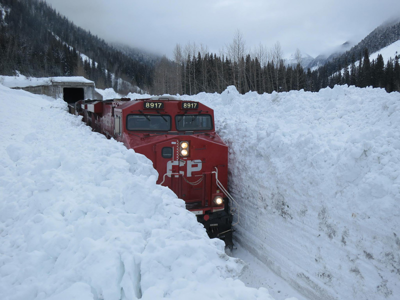
How about another snow photo to hold you snow lovers over?

Photograph by Parks Canada So apparently there’s a little bit of snow in western Canada! This photo was taken in Glacier National Park in the province of British Columbia and shows a train rumbling through snow banks as high as the train itself! Glacier National Park is one of seven national parks in British…

I don’t have anything exciting to track in the long range. The system we have been watching for next week keeps popping up and disappearing on the model data. More off than on. For now I will just keep watching the data. There will be several weather disturbances to track next week into the following week.
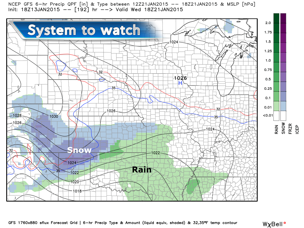
The GFS model is showing some sort of system trying to develop to our southwest next Wednesday. This system also shows up on the Canadian weather model.
Images from www.weatherbell.com
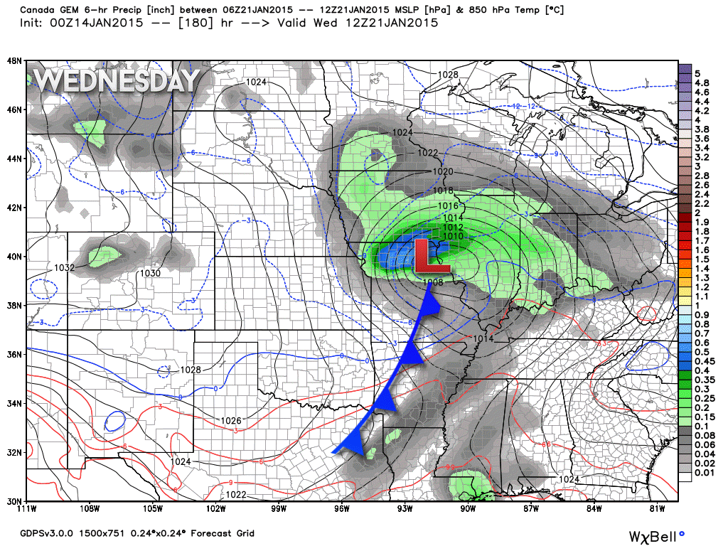
The Canadian weather model (which has been so-so lately in the accuracy department) is picking up on the system for the middle of next week. Remember that the GFS model went bonkers with this system. The GFS no longer is showing the system. The EC model is showing it from time to time. The idea of a system or two later next week is on the table.
If a system does develop then the odds favor it being a rain producer. Just keep that in mind. Long way off…lots can change but that is what the data is currently showing.
Here is the Canadian models depiction of that storm. You can see the area of low pressure passing to our northwest. If that happens then we will be in the rain sector of the system.
Right now it appears that the cold weather will stay awhile for awhile – really cold weather, I should say.
The pattern may reload as we head into late January and February. That would mean colder temperatures and perhaps a more active storm track. This would be in response to the Arctic Oscillation (AO) going negative. That might mean a stormier pattern as blocking occurs way to our north and east. Systems get blocked and that means they can’t just skirt off to our south and east. They would develop and move northeast into the Ohio and Tennessee Valley. When that happens our weather becomes more interesting. We shall see if that happens.
There are some other indicators that lead to believe February might be stormy.

Please visit your local National Weather Service Office by clicking here. The National Weather Service Office, for our region, is located in Paducah, Kentucky. They have a lot of maps and information on their site. Local people…local forecasters who care about our region.

We have regional radars and local city radars – if a radar does not seem to be updating then try another one. Occasional browsers need their cache cleared. You may also try restarting your browser. That usually fixes the problem. Occasionally we do have a radar go down. That is why I have duplicates. Thus, if one fails then try another one.
If you have any problems then please send me an email beaudodson@usawx.com
WEATHER RADAR PAGE – Click here —
We also have a new national interactive radar – you can view that radar by clicking here.
Local interactive city radars include St Louis, Mt Vernon, Evansville, Poplar Bluff, Cape Girardeau, Marion, Paducah, Hopkinsville, Memphis, Nashville, Dyersburg, and all of eastern Kentucky – these are interactive radars. Local city radars – click here
NOTE: Occasionally you will see ground clutter on the radar (these are false echoes). Normally they show up close to the radar sites – including Paducah.
![]()
Current WARNINGS (a warning means take action now). Click on your county to drill down to the latest warning information. Keep in mind that there can be a 2-3 minute delay in the updated warning information.
I strongly encourage you to use a NOAA Weather Radio or warning cell phone app for the most up to date warning information. Nothing is faster than a NOAA weather radio.


Color shaded counties are under some type of watch, warning, advisory, or special weather statement. Click your county to view the latest information.

Please visit your local National Weather Service Office by clicking here. The National Weather Service Office, for our region, is located in Paducah, Kentucky.
Many of my graphics are from www.weatherbell.com – a great resource for weather data, model data, and more
This blog was inspired by ABC 33/40’s Alabama Weather Blog – view their blog
Current tower cam view from the Weather Observatory- Click here for all cameras.

Southern Illinois Weather Observatory

The Weather Observatory

Southern Illinois Weather Observatory
WSIL TV 3 has a number of tower cameras. Click here for their tower camera page & Illinois Road Conditions

Marion, Illinois
WPSD TV 6 has a number of tower cameras. Click here for their tower camera page & Kentucky Road Conditions & Kentucky Highway and Interstate Cameras

Downtown Paducah, Kentucky
Benton, Kentucky Tower Camera – Click here for full view

Benton, Kentucky

I24 Paducah, Kentucky

I24 Mile Point 9 – Paducah, KY

I24 – Mile Point 3 Paducah, Kentucky

You can sign up for my AWARE email by clicking here I typically send out AWARE emails before severe weather, winter storms, or other active weather situations. I do not email watches or warnings. The emails are a basic “heads up” concerning incoming weather conditions.


