
This forecast update covers far southern Illinois, far southeast Missouri, and far western Kentucky. See the coverage map on the right side of the blog.
Friday – A mix of sun and clouds. A chance for a couple of showers/sprinkles this afternoon. It will once again be on the cool side. High temperatures will be around 44 degrees. East winds at 10 mph.
Morning School Bus Stop Weather – A few clouds. Temperatures at the bus stop will be around 28 degrees. East winds at 5 mph.
Afternoon School Bus Stop Weather – Some clouds. Small chance for a shower. Chilly for November. Temperatures from 2 pm to 4 pm will be in the middle 40’s. East winds at 10 mph.
Friday night – Mostly cloudy. A small chance for showers/sprinkles. Chilly. Low temperatures around 40 degrees. South winds at 10 mph.
Saturday – Cloudy with a few showers possible. High temperatures will be near 56 degrees. South winds at 10 mph.
Saturday night – An increasing chance for showers and a few thunderstorms. Windy at times. Temperature steady or rising through the night. Low temperatures around 46 degrees. South winds at 10-20 mph.
Sunday – Cloudy. Gusty winds. A good chance for thunderstorms. A few storms could produce heavy rain and gusty winds. High temperatures will be in the upper 50’s and lower 60’s. Winds from the south at 10-25 mph with gusts above 35 mph.
Confidence in the above forecast:

An explanation of what is happening in the atmosphere over the coming days.
If you enjoy the weather blog, the Weather Observatory web-site, the interactive weather radars, and everything else then consider giving a donation to keep the bills paid. For more information on how you can help – click here
A weak weather system pushes into the region today. Clouds with a chance for a light shower or sprinkles will accompany this disturbance. I don’t see the precipitation chances today into Saturday as being a big deal. Many spots may remain dry.
A much stronger system arrives Saturday night and Sunday. A deep area of low pressure will push through Missouri and into Illinois by Sunday afternoon. Typically this would be a track that would bring severe thunderstorms to our region. Thankfully instability is going to be minimal on Sunday.
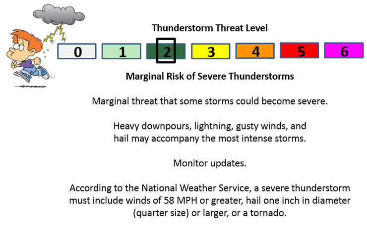
If, however, instability is greater than forecast then we may have to deal with a few severe thunderstorms. Right now the risk appears small or marginal. Monitor updates, as always.
Rain and thunderstorm chances will dramatically increase late Saturday night into Sunday. Some of the storms could produce heavy downpours and gusty winds.
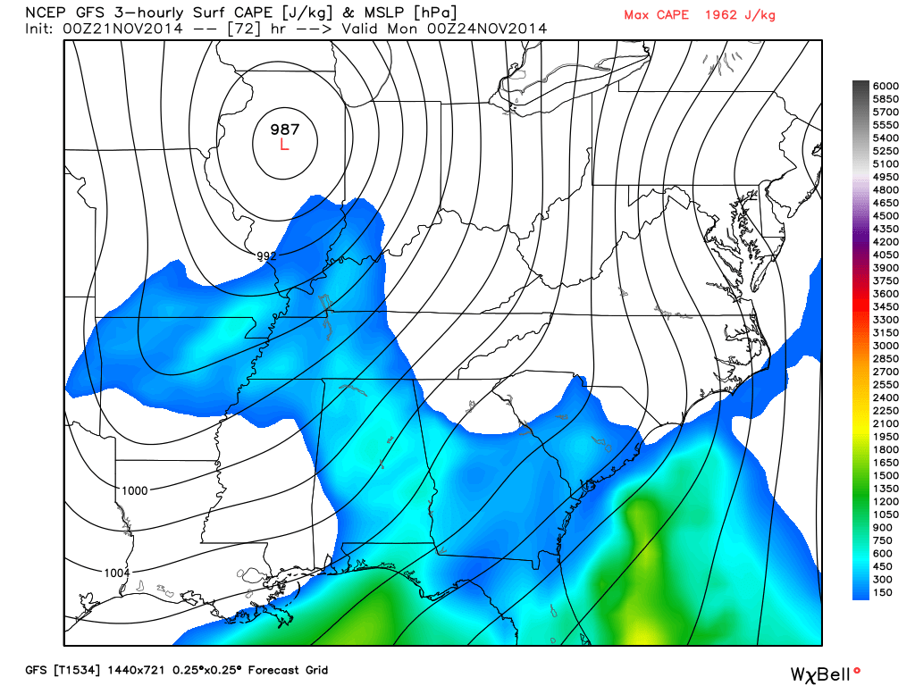
The high resolution GFS has been insistent that some CAPE will form on Sunday. CAPE is a necessary ingredient for severe weather in our region. It basically means energy. Something to keep an eye on.
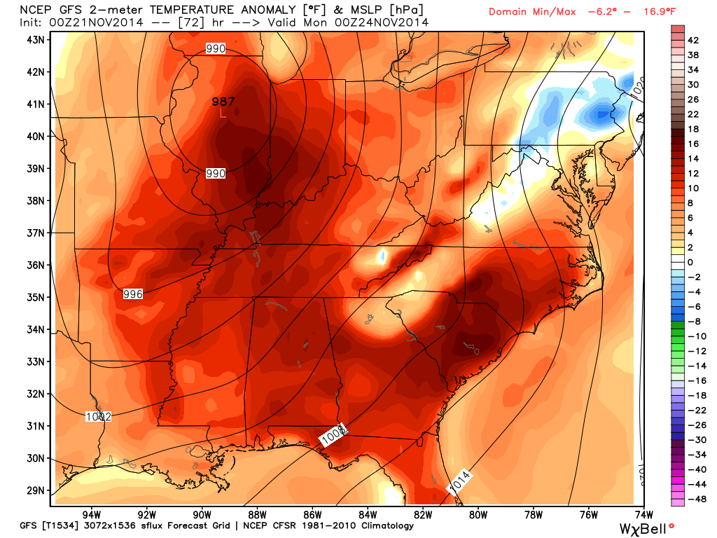
This graphic shows you the 987 mb low passing into central Illinois on Sunday evening. That is an impressive low. The isobars (equal lines of pressure) are wrapped tightly around it. That blue area indicates CAPE.
Temperatures will be on the rise ahead of this storm. I suspect some of our counties will reach into the 60’s on Sunday. Colder air then once again moves back into the region behind the storm system.
We just can’t get a break. But, since we will warm up, let’s take a look at how many degrees above normal temperatures will be on Sunday. See all that deep red – that is the above normal temperatures. Scale is on the right side of the image. That deep area of low pressure over central Illinois is doing a great job at pulling warmer air into our region.
Keep in mind that normal high temperatures for this time of the year are around 58-60 degrees. High temperatures into the 60’s are a good bet on Sunday. Some recent data show upper 50’s – so, perhaps not quite as above normal as this graphic shows, but you get the general idea.
I know what you are thinking – you are thinking “Beau, can’t we just keep those temperatures”

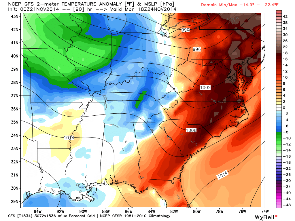
And the answer is, NO. Apparently not. By Monday afternoon temperature anomalies will once again be on the decline. Again, the scale is on the right side of the page. That scale tells you how many degrees below normal we will be. At least it isn’t showing 20 or 30 degrees below normal. It could always be worse (I will spare you the Buffalo, New York snow photos in this blog update)
We will have to see what time the colder air moves back in on Monday. Overall, temperatures will be on the decline as we move into next week.
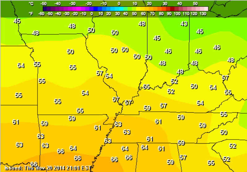
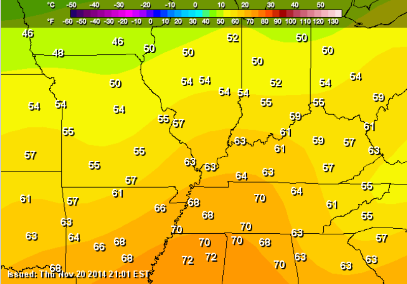
Check out the high temperature maps for today into Sunday – you can definitely see the warming trend.
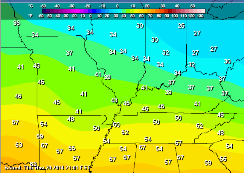
FRIDAY
SATURDAY
SUNDAY
Let’s take a look at the current temperature map across the region.

Current National Temperature Map


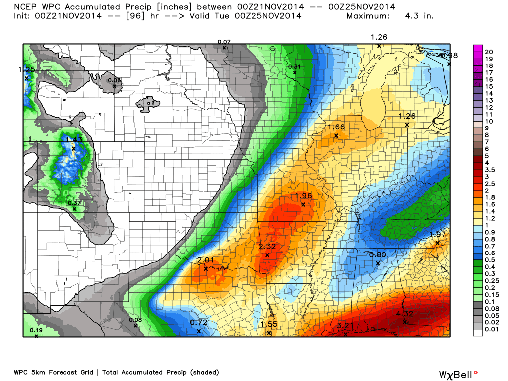
I increased the rainfall totals from 0.40″-0.80″ to 0.50″-1.00″. Most of that will fall on Saturday night and Sunday.
I also tweaked Sunday’s high temperatures. A bit iffy on how high temperatures will rise. Clouds and rain may keep temperatures from reaching their maximum potential. We will see.

Thunderstorms on Sunday could produce gusty winds and heavy downpours.

A few showers into Saturday. Perhaps throw the umbrella in the car. Widespread showers and thunderstorms enter the picture on Saturday night into the day on Sunday.

The Wild Card gives you an idea of what might change that would cause the forecast to bust. A busted forecast means a forecast that does not verify.
Wild card in this forecast – whether or not a few storms will approach or reach severe levels on Sunday. This will be dependent on the atmosphere becoming more unstable that expected. If the sun comes out on Sunday then that would increase the risk for heavier storms. Monitor updates.

Precipitation forecast…
Rainfall totals from now until Monday will be in the 0.50″-1.00″ range. Locally heavier amounts likely. Some places may pick up more than 1″ of rain. The bulk of the rain will fall late Saturday night into Sunday afternoon.
Precipitation today through Saturday afternoon should be less than 0.20″. Some spots will remain dry.
Scale for this graphic is on the right. This is a broad-brushed graphic – not everyone will pick up the totals shown. This will, however, give you a better idea of what might fall. Again, most of this is Saturday night into Sunday evening.

No winter weather concerns through Sunday afternoon.

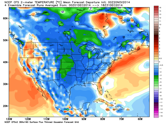
First off, I wanted to show you some of the new data for December. Are we going to have a cold December? Some of the data indicates temperatures will be below normal. Here is one of those data sets. Lot of blue on this map (below normal temperatures). This map shows you how many degrees or below normal the mean temperature will be in December (again, it is a forecast)
1. Colder air arrives by Monday
Well, you knew it was too good to last. Right? Our brief warmup this weekend will be followed by a prolonged period of colder than normal temperatures. Whether or not that means additional snow chances will need to be monitored. November is going to go down as one of the colder November’s in the nations history. Quite amazing spell of cold weather for so early in the season.
Several week impulses will approach the region next week. Depending on the track of each system, we may have some additional light precipitation chances from time to time.
Some extended temperature and precipitation outlooks…


The latest 8-14 day temperature and precipitation outlook. Note the dates are at the top of the image. These maps DO NOT tell you how high or low temperatures or precipitation will be. They simply give you the probability as to whether temperatures or precipitation will be above or below normal.


Can we expect severe thunderstorms over the next 24 to 48 hours? Remember that a severe thunderstorm is defined as a thunderstorm that produces 58 mph winds or higher, quarter size hail or larger, and/or a tornado.
Severe weather is not going to be a concern through Saturday.
Thunderstorms are possible Saturday night into Sunday. There may be a marginal risk that a few storms become severe on Sunday. Monitor updates as we move forward.

Please visit your local National Weather Service Office by clicking here. The National Weather Service Office, for our region, is located in Paducah, Kentucky.
![]()
We have regional radars and local city radars – if a radar does not seem to be updating then try another one. Occasional browsers need their cache cleared. You may also try restarting your browser. That usually fixes the problem. Occasionally we do have a radar go down. That is why I have duplicates. Thus, if one fails then try another one.
If you have any problems then please send me an email beaudodson@usawx.com
WEATHER RADAR PAGE – Click here —
We also have a new national interactive radar – you can view that radar by clicking here.
Local interactive city radars include St Louis, Mt Vernon, Evansville, Poplar Bluff, Cape Girardeau, Marion, Paducah, Hopkinsville, Memphis, Nashville, Dyersburg, and all of eastern Kentucky – these are interactive radars. Local city radars – click here
NOTE: Occasionally you will see ground clutter on the radar (these are false echoes). Normally they show up close to the radar sites – including Paducah.

Regional Radar – Click on radar to take you our full radar page.


Regional Radar

Current WARNINGS (a warning means take action now). Click on your county to drill down to the latest warning information. Keep in mind that there can be a 2-3 minute delay in the updated warning information.
I strongly encourage you to use a NOAA Weather Radio or warning cell phone app for the most up to date warning information. Nothing is faster than a NOAA weather radio.


Missouri Warnings

Illinois Warnings

Kentucky Warnings
I have added a lot of new maps to the Southern Illinois Weather Observatory web-site. Check them out by clicking here.
Current tower cam view from the Weather Observatory- Click here for all cameras.

Southern Illinois Weather Observatory

The Weather Observatory

Southern Illinois Weather Observatory
WPSD TV 6 has a number of tower cameras. Click here for their tower camera page
& Kentucky Road Conditions & Kentucky Highway and Interstate Cameras

Downtown Paducah, Kentucky
Benton, Kentucky Tower Camera – Click here for full view

Benton, Kentucky
WSIL TV 3 has a number of tower cameras. Click here for their tower camera page
& Illinois Road Conditions

Marion, Illinois

I24 Paducah, Kentucky

I24 Mile Point 9 – Paducah, KY

I24 – Mile Point 3 Paducah, Kentucky

You can sign up for my AWARE email by clicking here I typically send out AWARE emails before severe weather, winter storms, or other active weather situations. I do not email watches or warnings. The emails are a basic “heads up” concerning incoming weather conditions.