
I am going to try to streamline the blog. Centered on the most important aspects of the forecast.
.

Key Messages
⛈️ Today and tonight
Several rounds of thunderstorms are expected today, bringing periods of heavy rain and the potential for a few severe storms capable of producing damaging winds or a brief low-end tornado. Monitor your Beau Dodson Weather App. The threat of heavy rainfall and flash flooding is increasing, and a Flash Flood Watch (see below) is in effect for parts of the region.
Tuesday and Tuesday night
Chances of showers and thunderstorms will continue on Tuesday. Some of the thunderstorms on Tuesday could also be intense with strong wind gusts. Lower chances of thunderstorms from Tuesday night through Thursday morning.
Heat and Humidity
🥵 The hottest weather of the season so far arrives on Tuesday. High temperatures will approach 90 degrees, and when combined with high humidity, it will feel closer to 100 degrees through Thursday. Some relief is expected by Friday.
Thursday through Sunday
⛈️ Another weather system is expected late Thursday into Friday, bringing another chance for showers and thunderstorms. A few storms could be strong.
The weekend will be quite warm. A bit less muggy. Perhaps a low chance of isolated showers and thunderstorms (likely <20%). I will monitor that.
.
The Bottom Line
- Today into this evening: Scattered to numerous showers and thunderstorms, some strong, with heavy rain possible.
- At least scattered showers and thunderstorms on Tuesday. A few storms could be strong.
- Wednesday through Thursday: Lower chances of thunderstorms on Wednesday through Thursday morning. Hot and very humid, with heat index values near or above 100°.
- Thursday afternoon into Friday: Another round of showers and storms may move into the region. Some could be strong.
- The weekend looks warm. Less humid. Maybe some isolated thunderstorms. Low confidence in thunderstorms on Saturday and Sunday. High confidence in it being quite warm.
.

.

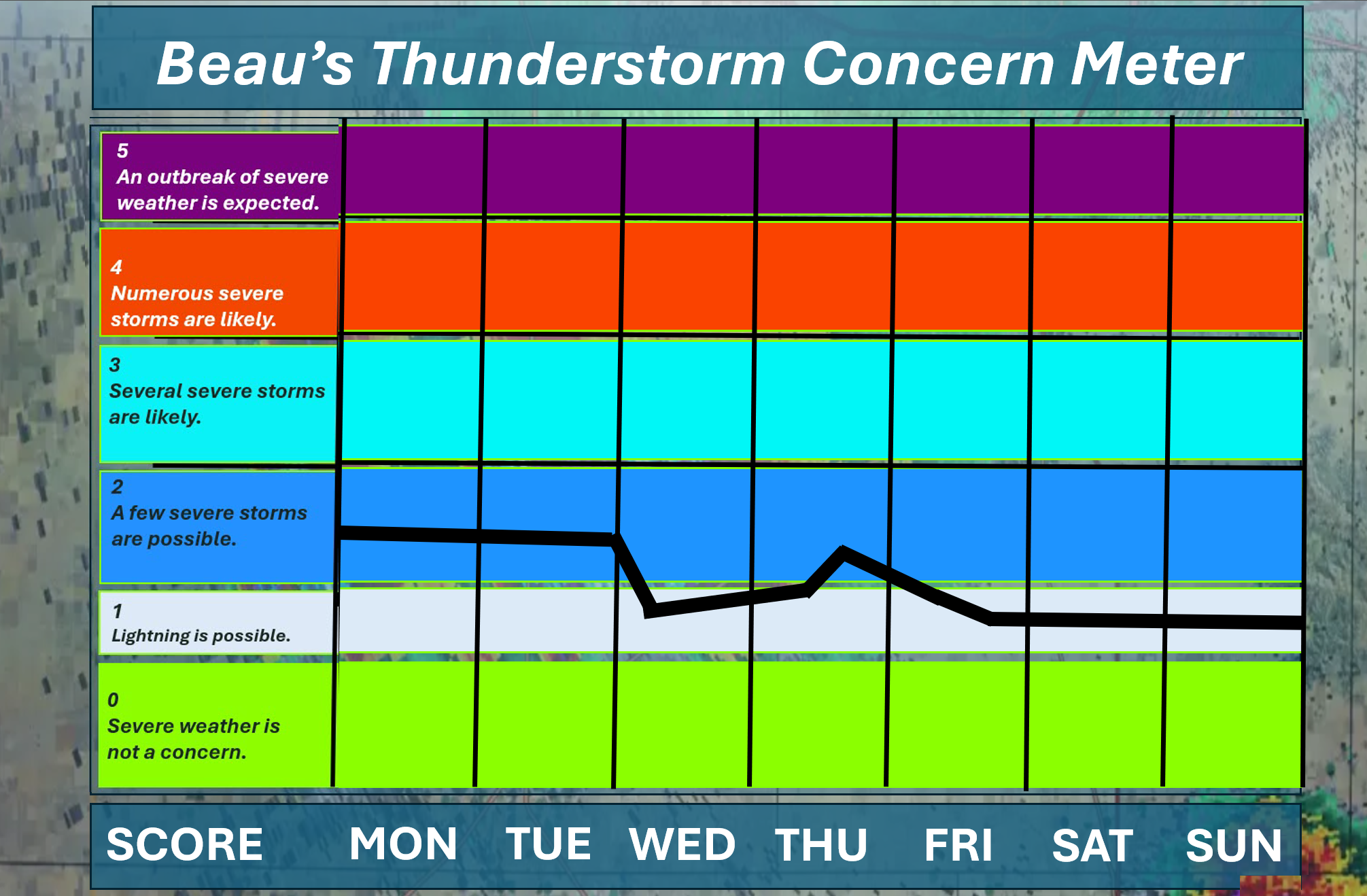
🌪️ Seven-Day Tornado and Severe Weather Outlook ⛈️
June 8th through June 14th
Current severe weather risk: POSSIBLE. A few of the thunderstorms today and tomorrow could produce strong wind gusts and small hail. There is a risk that a few of the thunderstorms will produce damaging wind gusts. I am monitoring Thursday and Friday as well.
Current tornado risk: LOW (but not zero). We will have thunderstorms today. There is a bit of spin in the atmosphere. I can’t rule out a brief low-end tornado or a landspout. These tend to last a few minutes. These types of weather setups tend to be in the EF0 to EF1 range. The threat of tornadoes on Tuesday is lower. Monitor your Beau Dodson Weather App.
Current confidence level on the tornado risk: Medium.
.
.

Seven-Day Hazardous Weather Outlook
1. Is lightning in the forecast? YES. A chance of lightning today through Tuesday night.
Chances of lightning Wednesday through Thursday morning are low. Another chance on Thursday afternoon into Friday.
Chances of lightning on Saturday and Sunday appear low for now. I will monitor it.
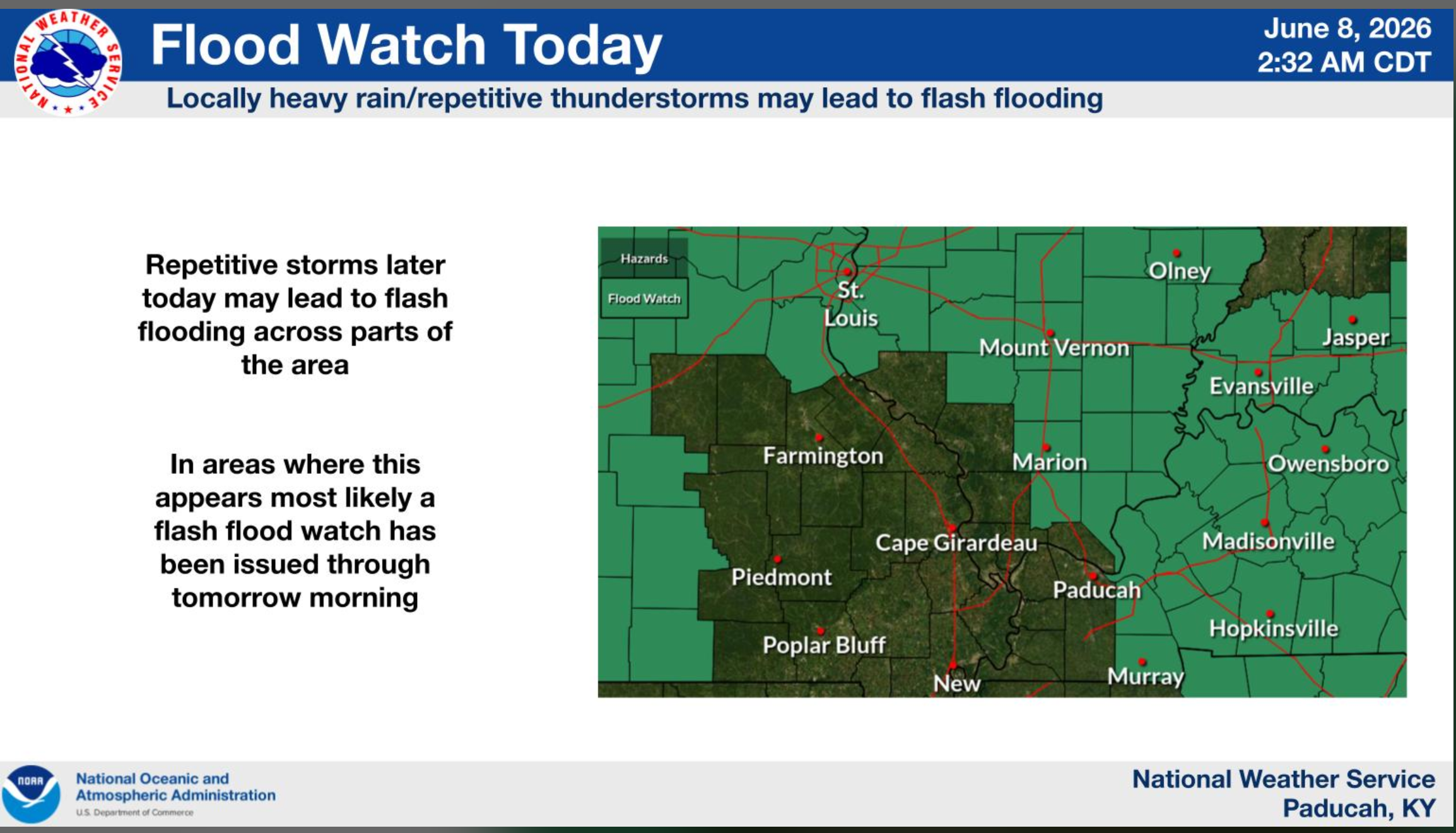
2. Is significant or widespread flash flooding in the forecast? SCATTERED ISSUES. A few of the thunderstorms over the coming days will produce heavy rain. If thunderstorms train over the same location, then pockets of flash flooding could develop. As always, avoid roadways that have significant flooding.
The moisture content of the atmosphere is extremely high (near record levels). That means that slow-moving thunderstorms can produce one to two inches per thirty minutes. These types of rainfall rates can cause problems. Avoid flooded roadways.
A flash flood watch has been issued for portions of the region. The green zone is the flood watch.
You can read the text of the flood watch here: CLICK HERE
.
3. Will non-thunderstorm winds top 40 mph? NO.
4. Will the temperature rise above 90 degrees? YES. A chance of 90 degrees or above on Tuesday, Wednesday, and Thursday. I will monitor Friday and Saturday (upper 80s are likely).
5. Is the heat index forecast to rise above 100 degrees? POSSIBLE. Tuesday, Wednesday, and Thursday. Heat index values will reach the upper nineties and possibly exceed 100 degrees. This will depend on cloud cover and thunderstorms. Clouds would keep temperatures a bit lower.
6. Is the heat index forecast to rise above 110 degrees? NO.
Your body responds to the heat index. The heat index is more important than the actual temperature. More information about the heat index: Click here.
.


.
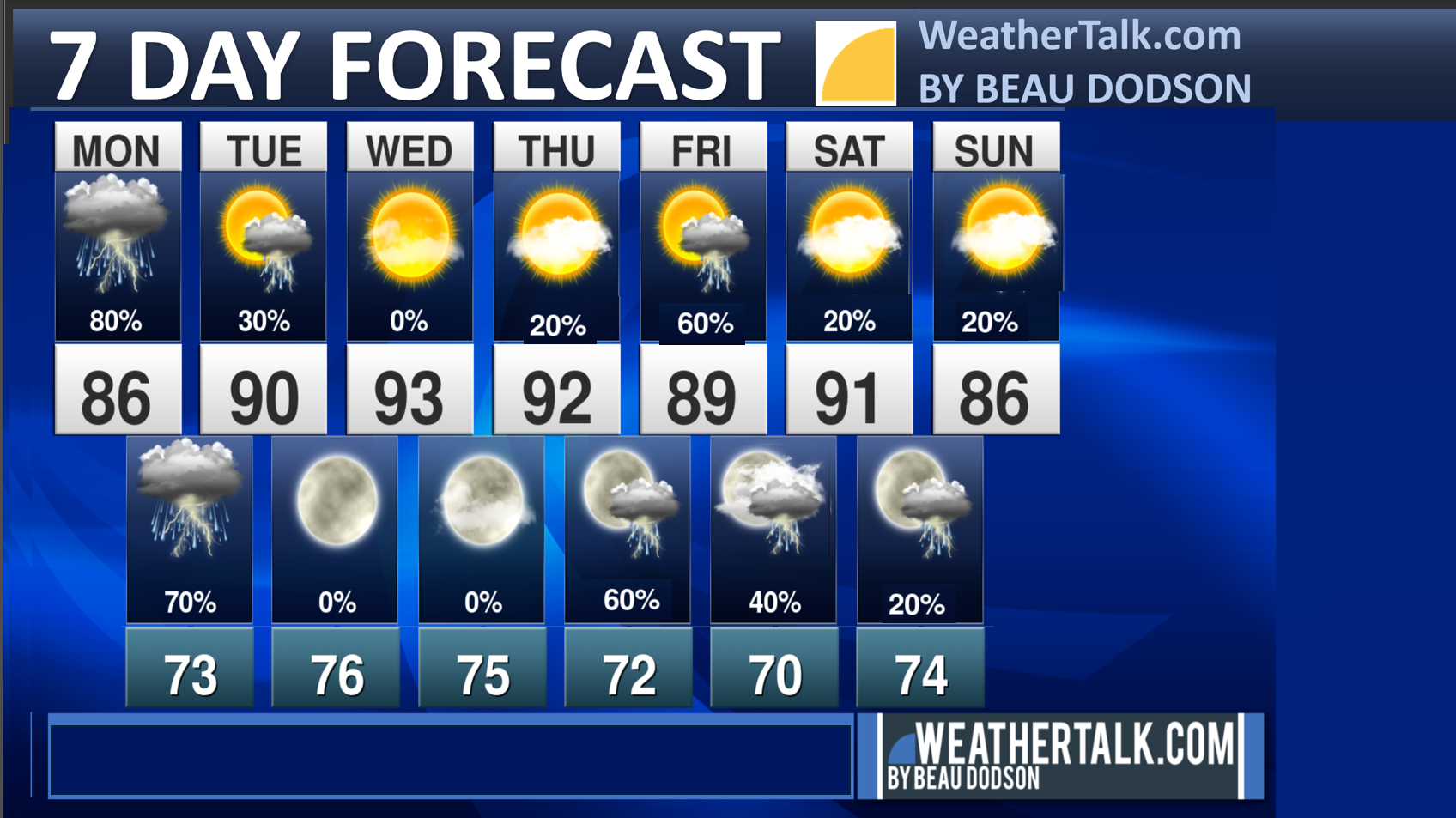
Seven-day outlook graphic.
This is a broad-brush overview of the entire region.
* Scroll down to see your local city rain probability maps.
.

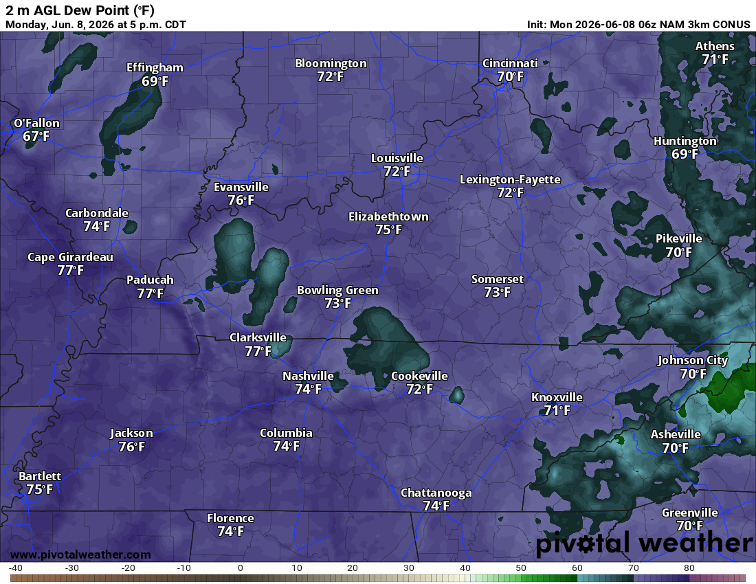
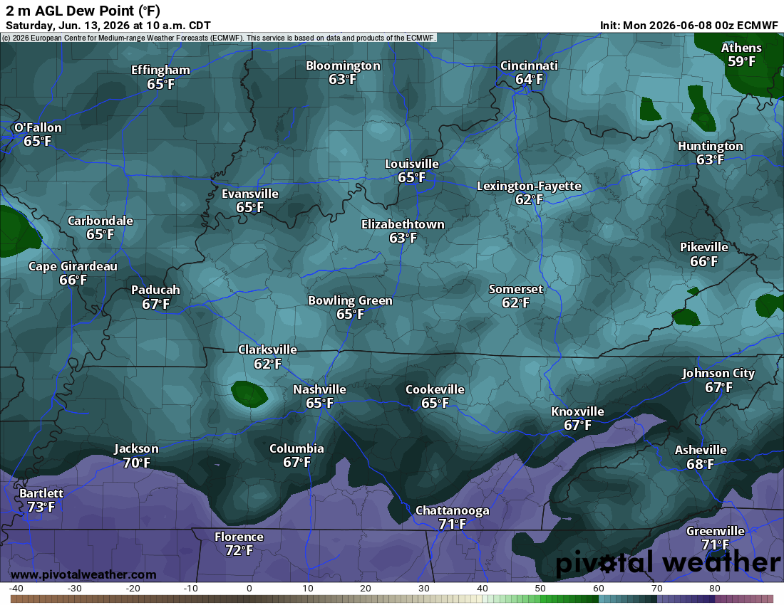
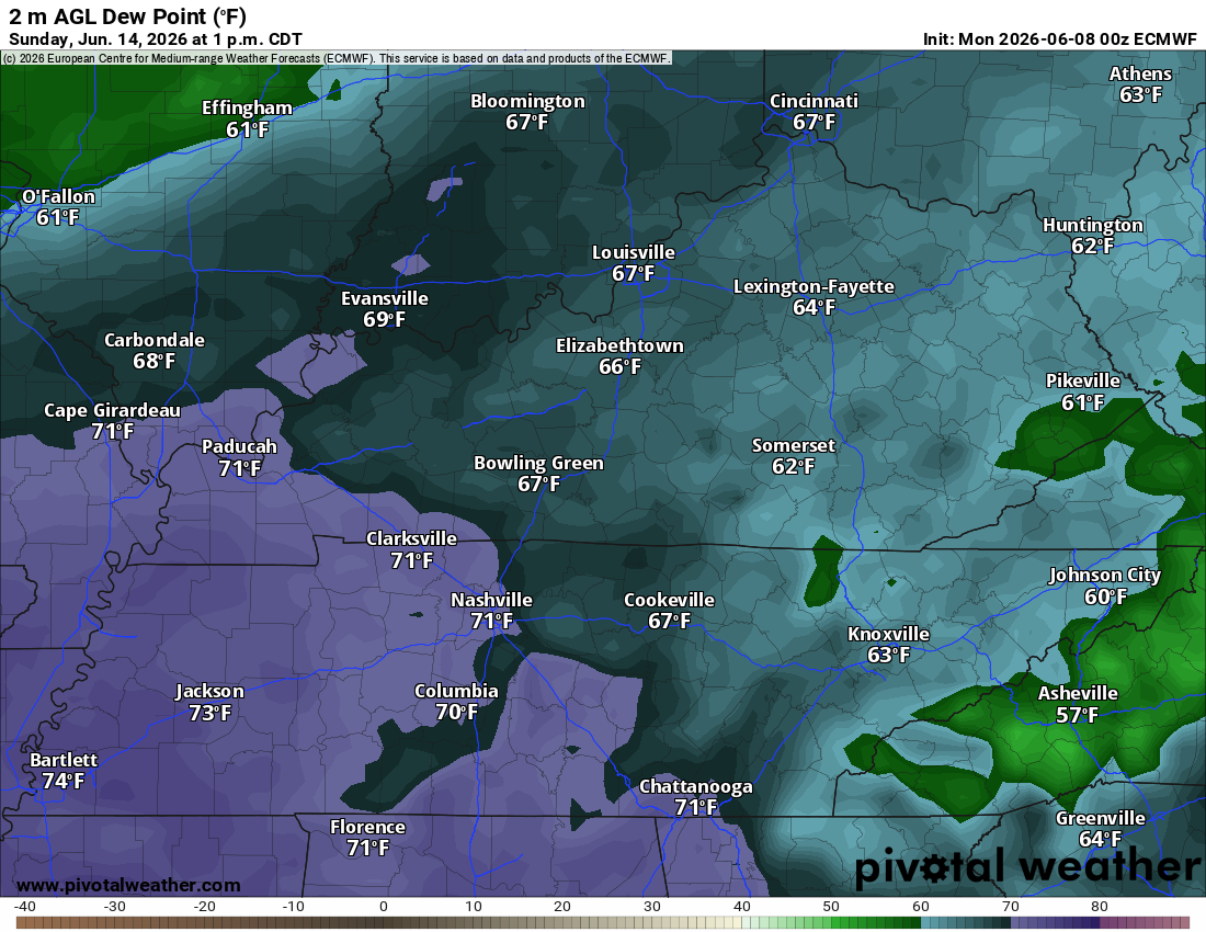
Dew Points. A muggy few days ahead of us.
Notice how humid it feels outside today? That is because we have high dew points. Dew point measures the moisture in the air. It is a better gauge of “mugginess” than humidity.
Look at today’s dew points. Muggy!
Dew points in the mid to upper 70s. That is air you wear. Uncomfortable.
By Saturday and Sunday, the dew point temperatures will be a bit lower. It will feel a bit better outside than the coming days.
Saturday dew points (the graphic below)
Sunday dew points
.
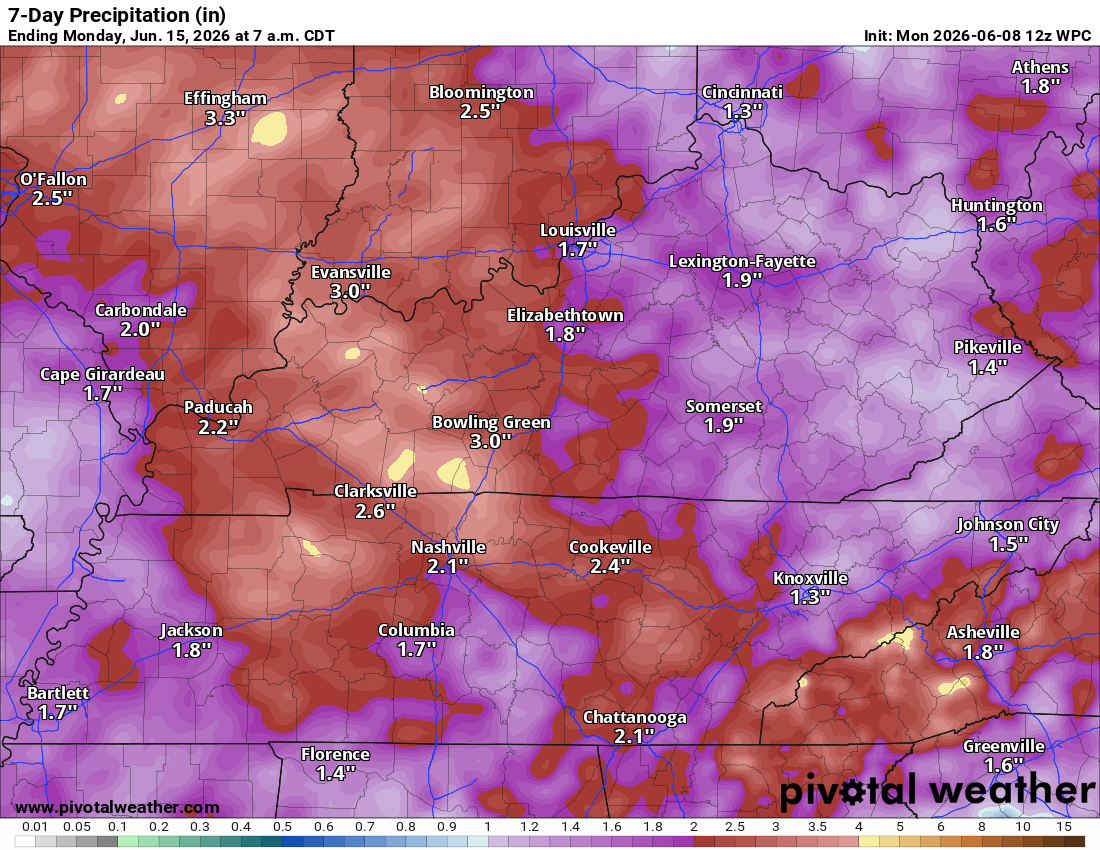
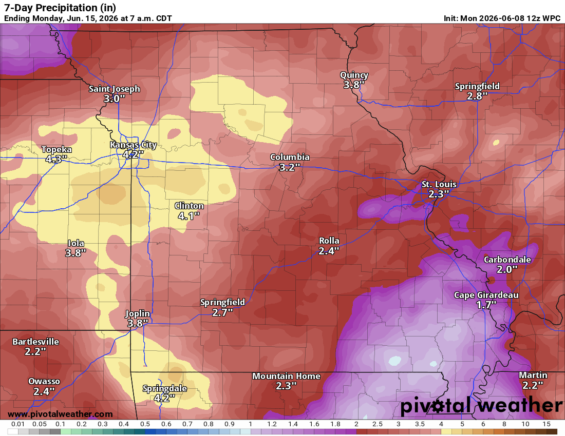
Let’s Look At The Seven-Day Rainfall Totals Forecast
General rainfall total maps for today through next Monday morning.
* As is typical for late spring, totals will vary greatly. Thunderstorms can double your rainfall totals. Keep that in mind. I would not be surprised if a few spots receive more than three inches of rain this week. Perhaps in a short amount of time.
.
Western view.
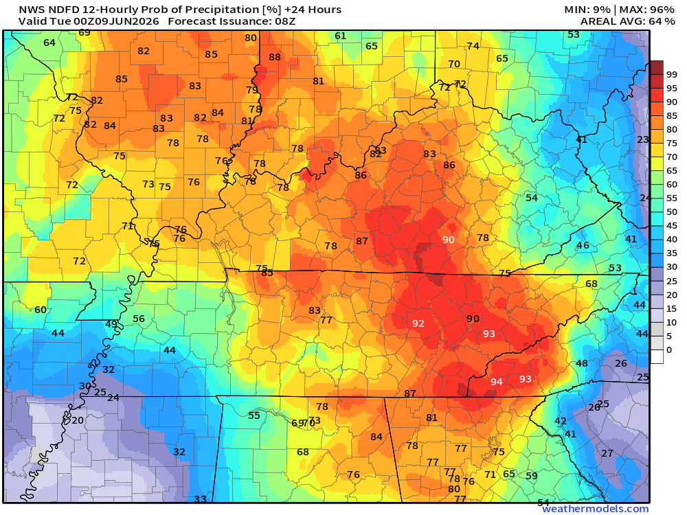
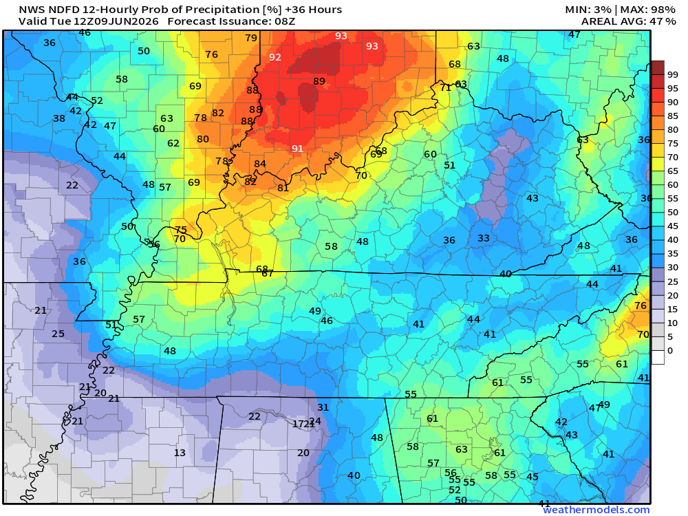
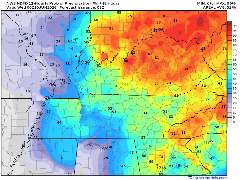
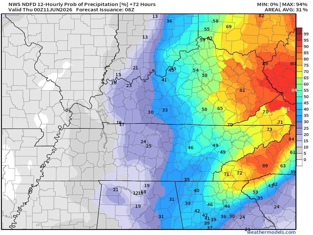
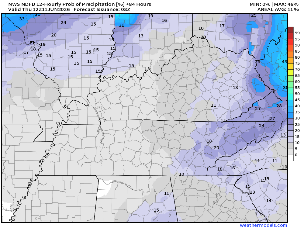
Let’s look at the four-day rain probability maps. What is the % chance of rain?
These maps are broken down into 12-hour time periods.
* Remember, a 20% chance of rain during the summer months does not mean that it will not rain. It means there will be a few thunderstorms on the radar.
Double-click maps to enlarge them.
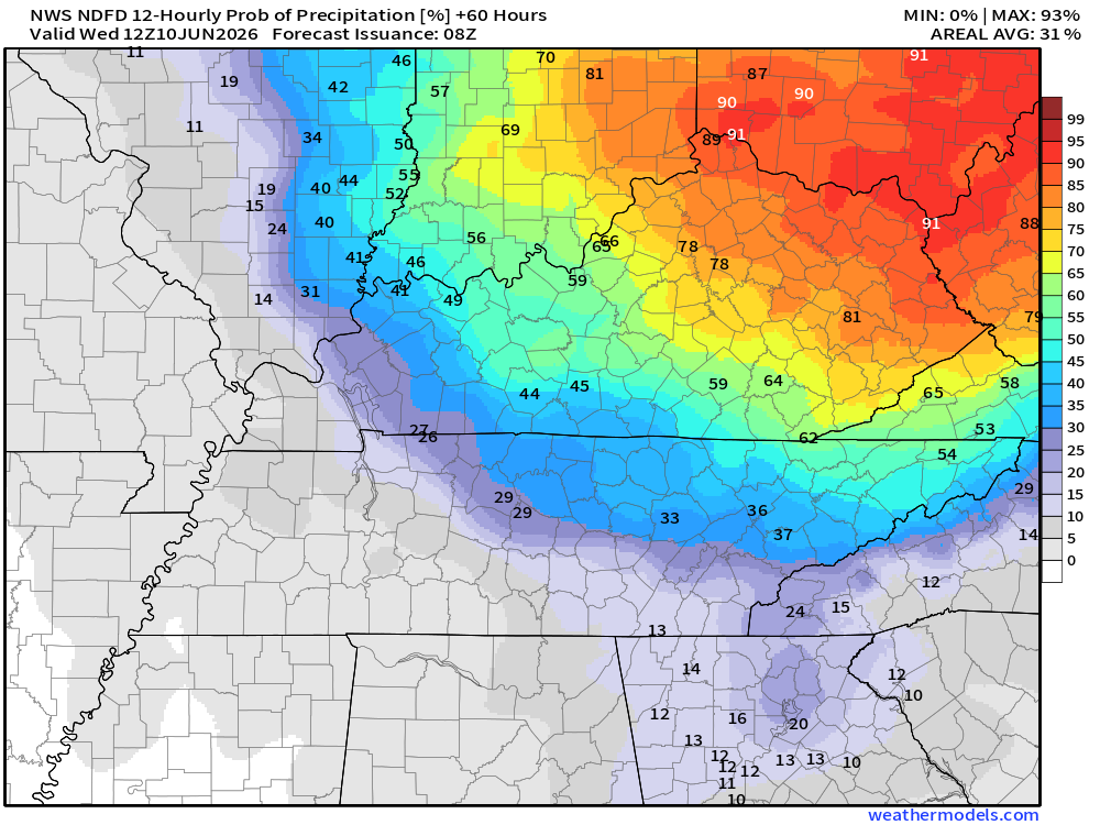
7 AM Wednesday to 7 PM Wednesday
.
7 PM Wednesday to 7 AM Thursday

Green is rain. Yellow is moderate rain. Orange indicates locally heavy rain.
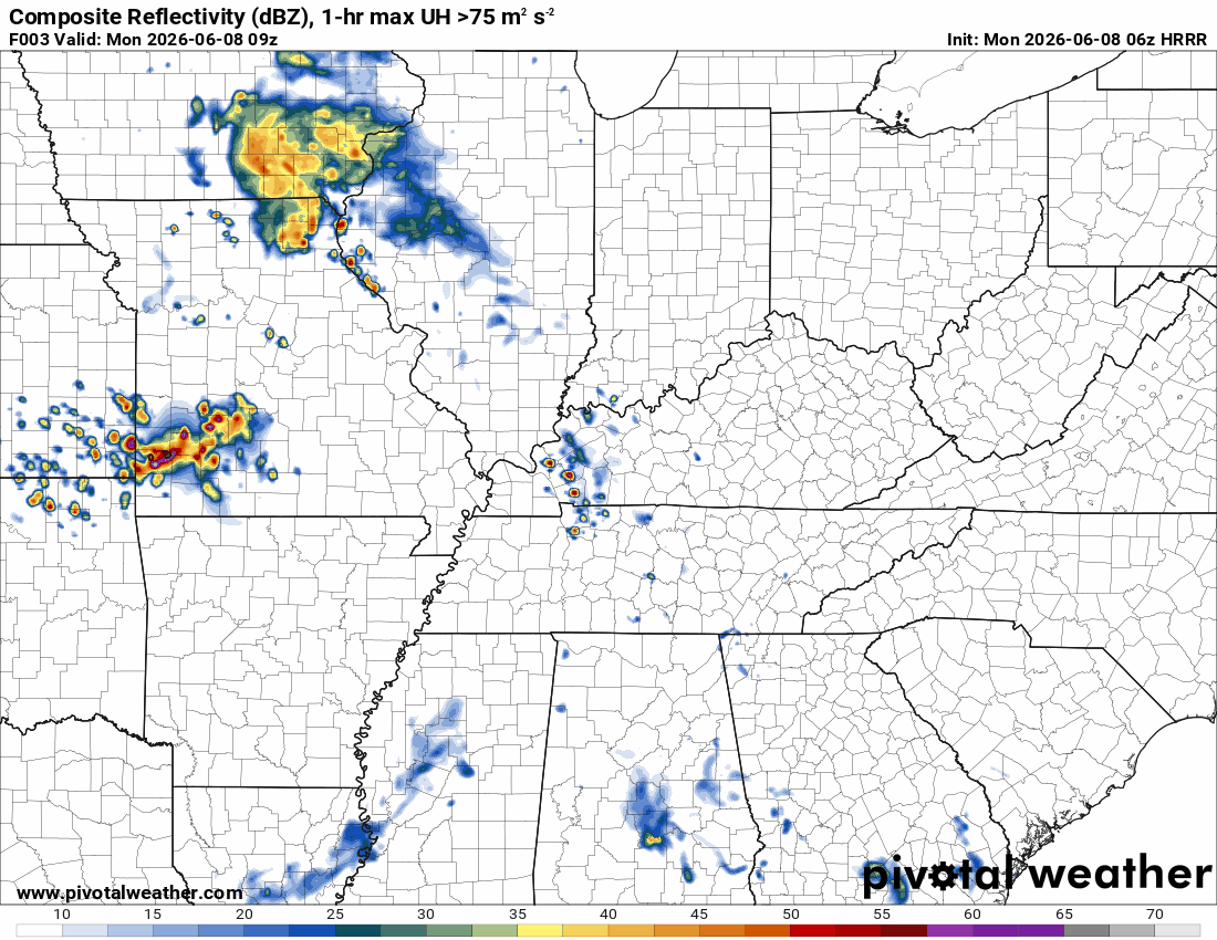
Double-click the animation to enlarge it.
* Future-cast radars are never exact. Take the general idea from this animation. These models do their best to forecast where thunderstorms will develop and move.
The timestamp (upper left) is in Zulu. 12z=7 am. 18z=1 pm. 00z=7 pm.
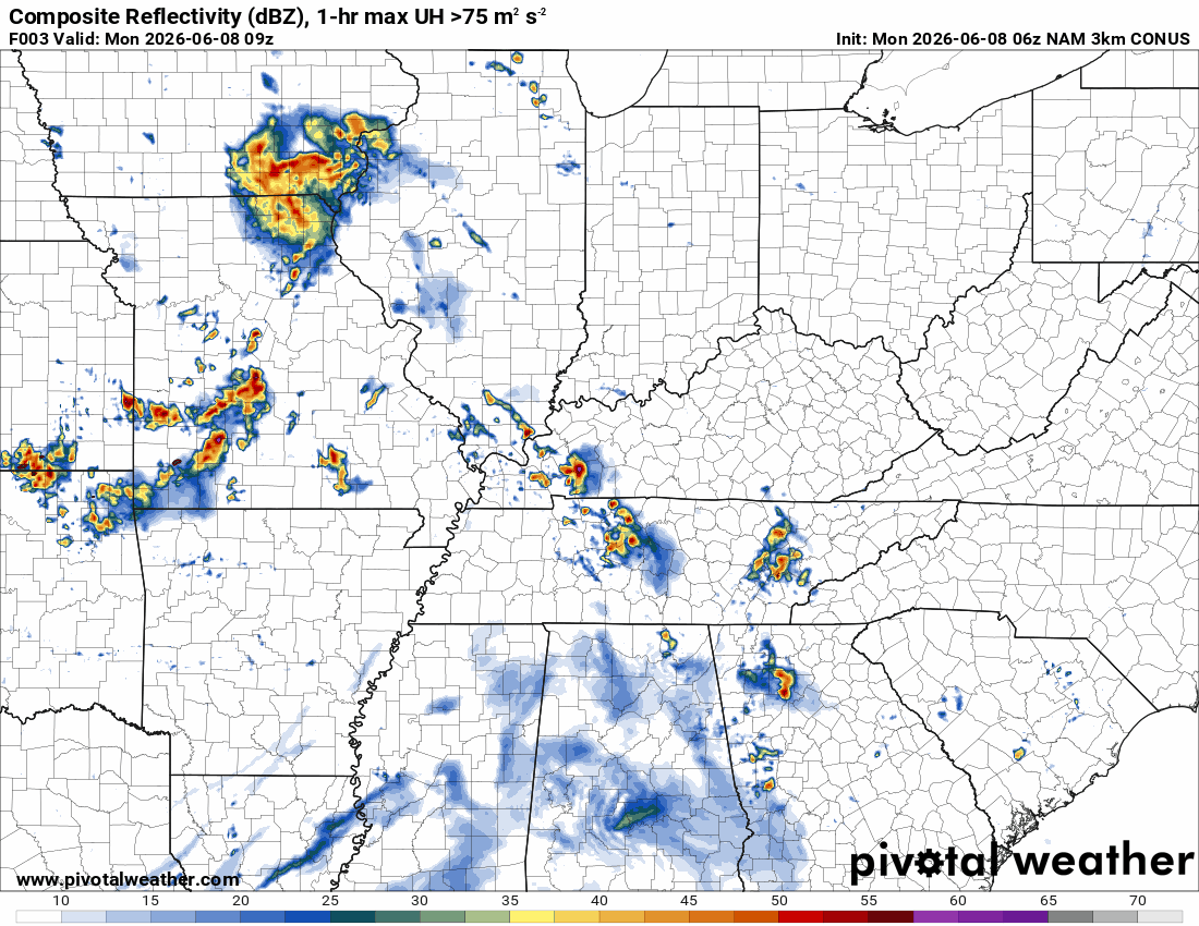
Hrrr Model
NAM 3k Model
..
.
Click here if you would like to return to the top of the page.
.Average high temperatures for this time of the year are around 86 degrees.
Average low temperatures for this time of the year are around 65 degrees.
Average precipitation during this time period ranges from 1.00″ to 1.20″
Six to Ten Day Outlook.
Blue is below average. Red is above average. The no color zone represents equal chances.
Average highs for this time of the year are in the lower 60s. Average lows for this time of the year are in the lower 40s.

Green is above average precipitation. Yellow and brown favors below-average precipitation. Average precipitation for this time of the year is around one inch per week.

.

Live Radars and Lightning Data
Interactive-city-view radars. Clickable watches and warnings.
https://wtalk.co/B3XHASFZ
Regional Radar
https://imagery.weathertalk.com/prx/RadarLoop.mp4
** NEW ** Zoom radar with chaser tracking abilities!
ZoomRadar
Lightning Data (zoom in and out of your local area)
https://wtalk.co/WJ3SN5UZ
.

Average low temperatures for this time of the year are around 65 degrees.
Average precipitation during this time period ranges from 1.00″ to 1.30″
.
Eight to Fourteen Day Outlook.
Blue is below average. Red is above average. The no color zone represents equal chances.

Green is above average precipitation. Yellow and brown favors below average precipitation. Average precipitation for this time of the year is around one inch per week.

.
Radars and Lightning Data
Interactive-city-view radars. Clickable watches and warnings.
https://wtalk.co/B3XHASFZ
Old legacy radar site (some of you like it better)
https://weatherobservatory.com/weather-radar.htm
If the radar is not updating then try another one. If a radar does not appear to be refreshing then hit Ctrl F5. You may also try restarting your browser.
Backup radar site in case the above one is not working.
https://weathertalk.com/morani
Regional Radar
https://imagery.weathertalk.com/prx/RadarLoop.mp4
** NEW ** Zoom radar with chaser tracking abilities!
ZoomRadar
Lightning Data (zoom in and out of your local area)
https://wtalk.co/WJ3SN5UZ
Not working? Email me at beaudodson@usawx.com

Live lightning data: Click here.
Real time lightning data (another one) https://map.blitzortung.org/#5.02/37.95/-86.99
.
.
We have a new service to complement your www.weathertalk.com subscription. This does NOT replace www.weathertalk.com It is simply another tool for you to receive severe weather information.
.
https://weathercallservices.com/beau-dodson-weather


Want to receive the daily forecast/other products on your Beau Dodson Weather app?
Did you know you have four options in your www.weathertalk.com account
You will then receive these via your Beau Dodson Weather app.
Just log into your www.weathertalk.com account
Click the NOTIFICATION SETTINGS TAB
Then, turn them on (green) and off (red)
🌪️ Number 1 is the most important one. Severe alerts, tornado alerts, and so on.
Number 2 is the daily video, blog, livestream alerts, and severe weather Facebook threads on severe days or winter storm days.
Number 3 is the daily forecast. I send that out every day during the afternoon hours. It is the seven-day forecast, hazardous weather outlook, fire outlook, and more.
Number 4 is to receive the daily video, blog, and other content on NON-severe weather days (every day without severe threats in other words)
GREEN IS ON
RED IS OFF

Want to add more products to your Beau Dodson Weather App?
Receive daily videos, weather blog updates on normal weather days and severe weather and winter storm days, your county by county weather forecast, and more!
Here is how to do add those additional products to your app notification settings!
The app is for subscribers. Subscribe at www.weathertalk.com/welcome then go to your app store and search for WeatherTalk
Subscribers, PLEASE USE THE APP. ATT and Verizon are not reliable during severe weather. They are delaying text messages.
The app is under WeatherTalk in the app store.

Apple users click here

Android users click here