We have some great sponsors for the Weather Talk Blog. Please let our sponsors know that you appreciate their support for the Weather Talk Blog.
Milner and Orr Funeral Home and Cremation Services located in Paducah, Kentucky and three other western Kentucky towns – at Milner and Orr they believe in families helping families. You can find Milner and Orr on Facebook, as well.
![]()
.

Wortham Dental Care located in Paducah, Kentucky. The gentle dentist. Mercury free dentistry. They also do safe Mercury removal. You can find Wortham Dental Care on Facebook, as well
.

For all of your families eye care needs. Visit their web-site here. Or, you can also visit their Facebook page.
.

Endrizzi’s Storm Shelters – For more information click here. Endrizzi Contracting and Landscaping can be found on Facebook, as well – click here
.

Best at Enabling Body Shop Profitability since 1996. Located In Paducah Kentucky and Evansville Indiana; serving all customers in between. They provide Customer Service, along with all the tools necessary for body shops to remain educated and competitive. Click the logo above for their main web-site. You can find McClintock Preferred Finishes on Facebook, as well
.

Duck/goose decoys? Game calls? Optics? We have you covered! Click the logo above or visit Final Flight on Facebook, as well.

This forecast update covers far southern Illinois, far southeast Missouri, and far western Kentucky. See the coverage map on the right side of the blog.
Remember that weather evolves. Check back frequently for updates, especially during active weather.
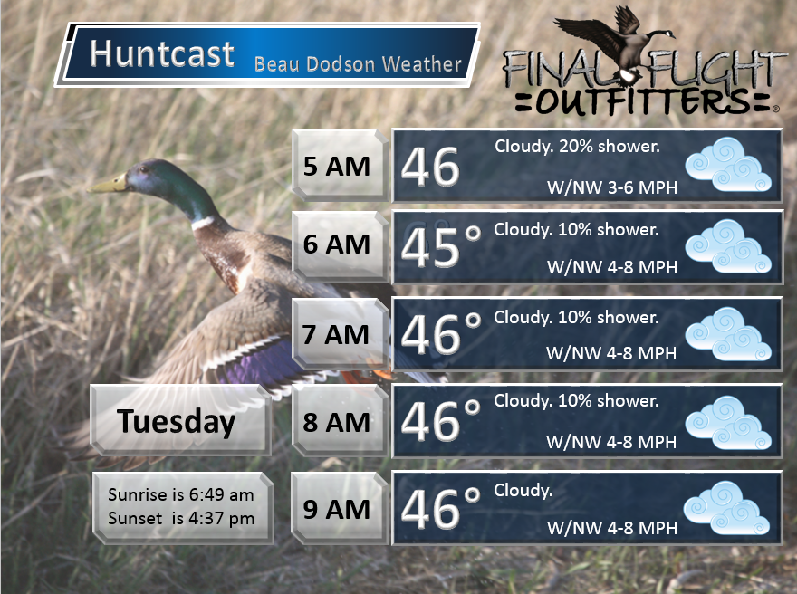
Tuesday – Cloudy early and cool. A chance for morning showers (before 3 am). We might see some clearing during the day.
Temperatures: Highs ranging from 44-50 degrees. Perhaps a few spots a bit higher.
Winds: West/southwest at 6-12 mph with gusts to 20 mph possible.
What is the chance for precipitation? 40% (before 3 am)
Coverage of precipitation? Scattered before 3 am
My confidence in this part of the forecast verifying is Medium
Should I be concerned about snow or ice? No
Should I cancel my outdoor plans? No
Is severe weather expected? No
What impact is expected? Wet roadways possible before 3 am.
Tuesday night – Clearing sky conditions.
Temperatures: Low temperatures in 34 to 38 degree range
Winds: North winds at 6-12 mph.
What is the chance for precipitation? 0%
Coverage of precipitation? None
My confidence in this part of the forecast verifying is High
Should I be concerned about snow or ice? No
Should I cancel my outdoor plans? No
Is severe weather expected? No
What impact is expected? None
Wednesday – A mix of sun and clouds. Fall like.
Temperatures: Highs will range from 44 to 48 degrees
Winds: North at 4-8 mph
What is the chance for precipitation? 0%
Coverage of precipitation? None
My confidence in this part of the forecast verifying is High
Should I be concerned about snow or ice? No
Should I cancel my outdoor plans? No
Is severe weather expected? No
What impact is expected? None
Wednesday night – Clear and cold.
Temperatures: Lows in the upper 20s to lower 30s
Winds: Northwest winds at 0 to 5 mph.
What is the chance for precipitation? 0%
Coverage of precipitation? None
My confidence in this part of the forecast verifying is High
Should I be concerned about snow or ice? No
Should I cancel my outdoor plans? No
Is severe weather expected? No
What impact is expected? None
Thursday – Mostly sunny. Near normal temperatures for late fall.
Temperatures: Highs in the 46 to 52 degree range
Winds: Northeast winds at 5-10 mph
What is the chance for precipitation? 0%
Coverage of precipitation? None
My confidence in this part of the forecast verifying is High
Should I be concerned about snow or ice? No
Should I cancel my outdoor plans? No
Is severe weather expected? No
What impact is expected? None
Thursday night – Clear and cool
Temperatures: Lows in the lower 30s
Winds: Northeast winds at 3-6 mph.
What is the chance for precipitation? 0%
Coverage of precipitation? None
My confidence in this part of the forecast verifying is High
Should I be concerned about snow or ice? No
Should I cancel my outdoor plans? No
Is severe weather expected? No
What impact is expected? None
Friday – Mostly sunny and cool
Temperatures: Highs in the lower 50s
Winds: Northeast/east winds at 5 mph
What is the chance for precipitation? 0%
Coverage of precipitation? None
My confidence in this part of the forecast verifying is High
Should I be concerned about snow or ice? No
Should I cancel my outdoor plans? No
Is severe weather expected? No
What impact is expected? None
Friday night – Clear and chilly
Temperatures: Lows in the lower to middle 30s
Winds: Northeast winds at 6-12 mph.
What is the chance for precipitation? 0%
Coverage of precipitation? None
My confidence in this part of the forecast verifying is High
Should I be concerned about snow or ice? No
Should I cancel my outdoor plans? No
Is severe weather expected? No
What impact is expected? None
Saturday – Mostly sunny. Just a few clouds. Cool.
Temperatures: Highs in the lower 50s
Winds: East winds at 5-10 mph
What is the chance for precipitation? 0%
Coverage of precipitation? None
My confidence in this part of the forecast verifying is High
Should I be concerned about snow or ice? No
Should I cancel my outdoor plans? No
Is severe weather expected? No
What impact is expected? None
Saturday night – Clear and chilly
Temperatures: Lows in the lower to middle 30s
Winds: Northeast winds at 5 mph.
What is the chance for precipitation? 0%
Coverage of precipitation? None
My confidence in this part of the forecast verifying is High
Should I be concerned about snow or ice? No
Should I cancel my outdoor plans? No
Is severe weather expected? No
What impact is expected? None
Sunday – Mostly sunny. Just a few clouds. Cool.
Temperatures: Highs in the lower to middle 50s
Winds: East winds at 5-10 mph
What is the chance for precipitation? 0%
Coverage of precipitation? None
My confidence in this part of the forecast verifying is Medium
Should I be concerned about snow or ice? No
Should I cancel my outdoor plans? No
Is severe weather expected? No
What impact is expected? None

Click their ad below to visit their web-site or click here reedelec.com


Don’t forget to check out the Southern Illinois Weather Observatory web-site for weather maps, tower cams, scanner feeds, radars, and much more! Click here

An explanation of what is happening in the atmosphere over the coming days…
Highlights
1. Rain showers on Monday night.
2. Rain ends on Tuesday morning.
3. A period of calm and cool weather ahead of us
4. Meteorological winter has arrived
We have one more round of showers to go. I know you are tired of showers! Aren’t we all. Even the weatherman is ready for some good ‘ole fashion sunshine.
The good news is that sun is on the way. We just have to get through Monday night and early Tuesday morning.
A cold front will pass through the region over the next 12 hours. Moving from west to east. The current thinking is almost all of the showers will be east of the area by 6 am on Tuesday morning. Perhaps a few lingering over our far eastern counties of western Kentucky. But, even there everything should be winding down.
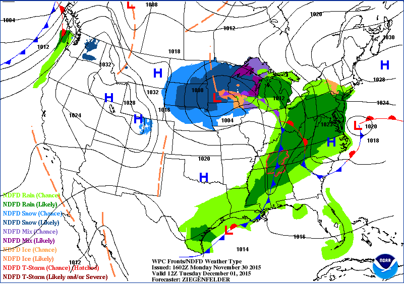
Let’s take a look at the weather map. I can show you that cold front. This first map is for Monday evening. You can see the front located over our region. See the blue line with triangles? That is the cold front. The green represent rain. Dark green is widespread rain. Light green represents scattered showers.
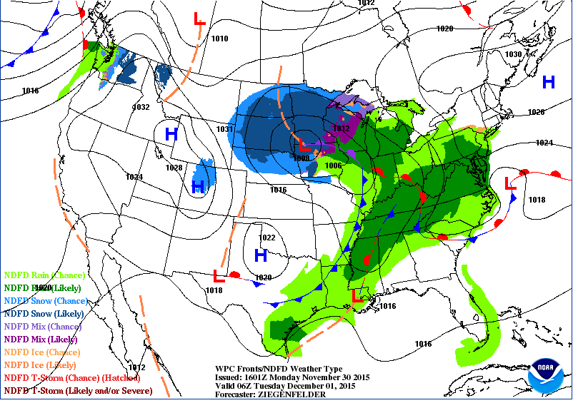
Let’s move ahead to 6 am on Tuesday morning. The front is now east of our region. The rain is exiting.
How about some cheering fans for the rains exit?
Rainfall totals along the cold front won’t be great. Expect most areas to pick up 0.05″-0.25″. A couple of spots could pick up higher totals near the Kentucky and Tennessee State line. But, not much more.
As we dry out on Tuesday we should see the sun start to make an appearance. A mix of sun and clouds. But, we will take anything at this point. Expect quite a bit of sun the rest of the week. Some data shows a few more clouds than sun on Thursday. Cool temperatures, but nothing extreme. More like seasonably cool temperatures. The first week of December will not be noteworthy in the weather department.
Our next weather system should hold off until next week. Another chance for rain showers around Tuesday. Long way off and confidence is usually low in that range.
Snow lovers, I do not have any snow in the forecast. Keep checking back.
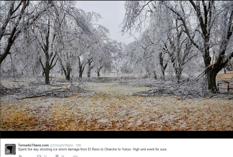
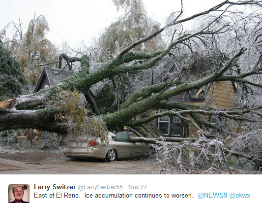
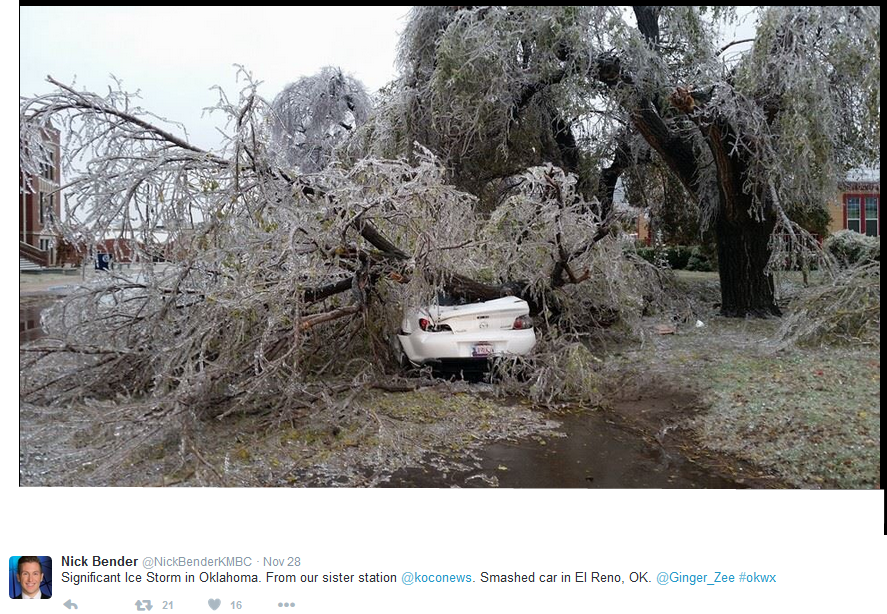
Check out these ice storm photographs from Oklahoma. Horrible ice even over the Thanksgiving holiday. Some places picked up more than 1″ of freezing rain.
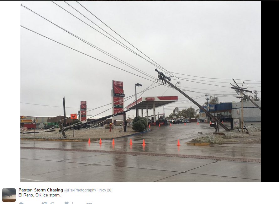
Twitter photographs
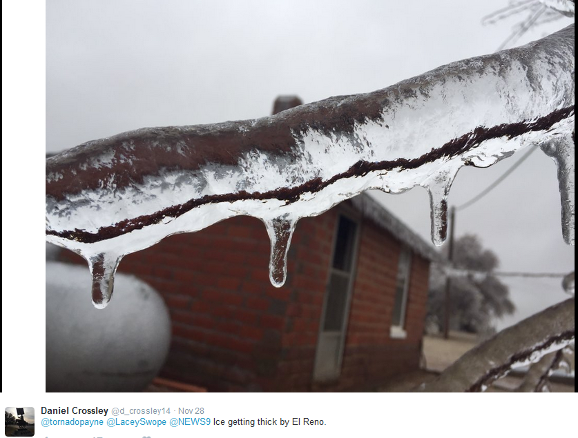
Twitter photographs
Twitter photographs
Twitter photographs
December 1 marks the beginning of “meteorological” winter — the winter solstice isn’t until December 21, but meteorologists round the seasons off: Dec-Jan-Feb is winter, Mar-Apr-May is spring, and so on. It is a bit easier to remember. It also tends to line up with the weather a bit more accurately. Not always, but usually. Meteorologists are a funny sort. We just like to do things differently.
Radar

WEATHER RADAR PAGE – Click here —
Click image below for watch or warning information


No snow anticipated.

No frozen precipitation through Sunday.

Small adjustments to the temperatures and wind. Otherwise, no significant changes to this forecast package.

No major concerns. Still some rises on area rivers and streams.

No

No wild card in this update.

Frost possible Wednesday, Thursday, and Friday mornings. Will have to monitor for freeze conditions.

How much precipitation should we expect over the next few days?
Rainfall totals on Monday night and early Tuesday morning will be light. Less than 0.25″.

Can we expect severe thunderstorms over the next 24 to 48 hours? Remember that a severe thunderstorm is defined as a thunderstorm that produces 58 mph winds or higher, quarter size hail or larger, and/or a tornado.
The thunderstorm threat level will be ZERO for Monday night through Saturday.
.
Tuesday: Severe weather is not anticipated.
Wednesday: Severe weather is not anticipated.
Thursday: Severe weather is not anticipated.
Friday: Severe weather is not anticipated.
Saturday: Severe weather is not anticipated.
Sunday: Severe weather is not anticipated.

Here is the official 6-10 day and 8-14 day temperature and precipitation outlook. Check the date stamp at the top of each image (so you understand the time frame).
The forecast maps below are issued by the Weather Prediction Center (NOAA).


The latest 8-14 day temperature and precipitation outlook. Note the dates are at the top of the image. These maps DO NOT tell you how high or low temperatures or precipitation will be. They simply give you the probability as to whether temperatures or precipitation will be above or below normal.


Here are the current river stage forecasts. You can click your state and then the dot for your location. It will bring up the full forecast and hydrograph.
Click Here For River Stage Forecasts…

Who do you trust for your weather information and who holds them accountable?
I have studied weather in our region since the late 1970’s. I have 37 years of experience in observing our regions weather patterns. My degree is in Broadcast Meteorology from Mississippi State University and an Associate of Science (AS). I am currently working on my Bachelor’s Degree in Geoscience.
My resume includes:
Member of the American Meteorological Society.
NOAA Weather-Ready Nation Ambassador.
Meteorologist for McCracken County Emergency Management.
I own and operate the Southern Illinois Weather Observatory.
Recipient of the Mark Trail Award, WPSD Six Who Make A Difference Award, Kentucky Colonel, and the Caesar J. Fiamma” Award from the American Red Cross.
In 2009 I was presented with the Kentucky Office of Highway Safety Award.
Recognized by the Kentucky House of Representatives for my service to the State of Kentucky leading up to several winter storms and severe weather outbreaks.
I am also President of the Shadow Angel Foundation which serves portions of western Kentucky and southern Illinois.
There is a lot of noise on the internet. A lot of weather maps are posted without explanation. Over time you should learn who to trust for your weather information.
My forecast philosophy is simple and straight forward.
- Communicate in simple terms
- To be as accurate as possible within a reasonable time frame before an event
- Interact with you on Twitter, Facebook, and the blog
- Minimize the “hype” that you might see on television or through other weather sources
- Push you towards utilizing wall-to-wall LOCAL TV coverage during severe weather events
I am a recipient of the Mark Trail Award, WPSD Six Who Make A Difference Award, Kentucky Colonel, and the Caesar J. Fiamma” Award from the American Red Cross. In 2009 I was presented with the Kentucky Office of Highway Safety Award. I was recognized by the Kentucky House of Representatives for my service to the State of Kentucky leading up to several winter storms and severe weather outbreaks.
If you click on the image below you can read the Kentucky House of Representatives Resolution.

Many of my graphics are from www.weatherbell.com – a great resource for weather data, model data, and more


You can sign up for my AWARE email by clicking here I typically send out AWARE emails before severe weather, winter storms, or other active weather situations. I do not email watches or warnings. The emails are a basic “heads up” concerning incoming weather conditions.