.
Monday, September 26, 2022
7 AM
For those traveling southward.
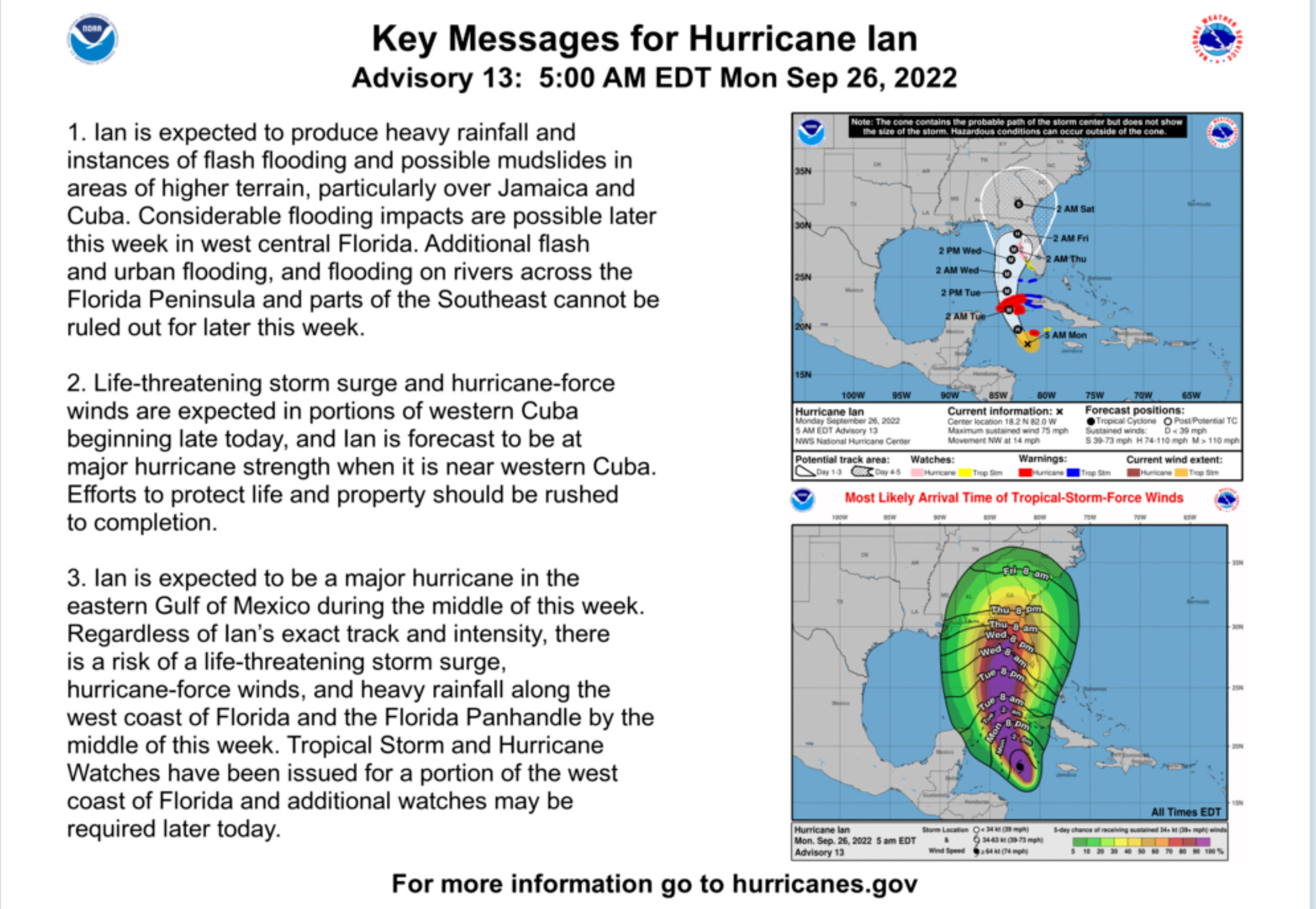
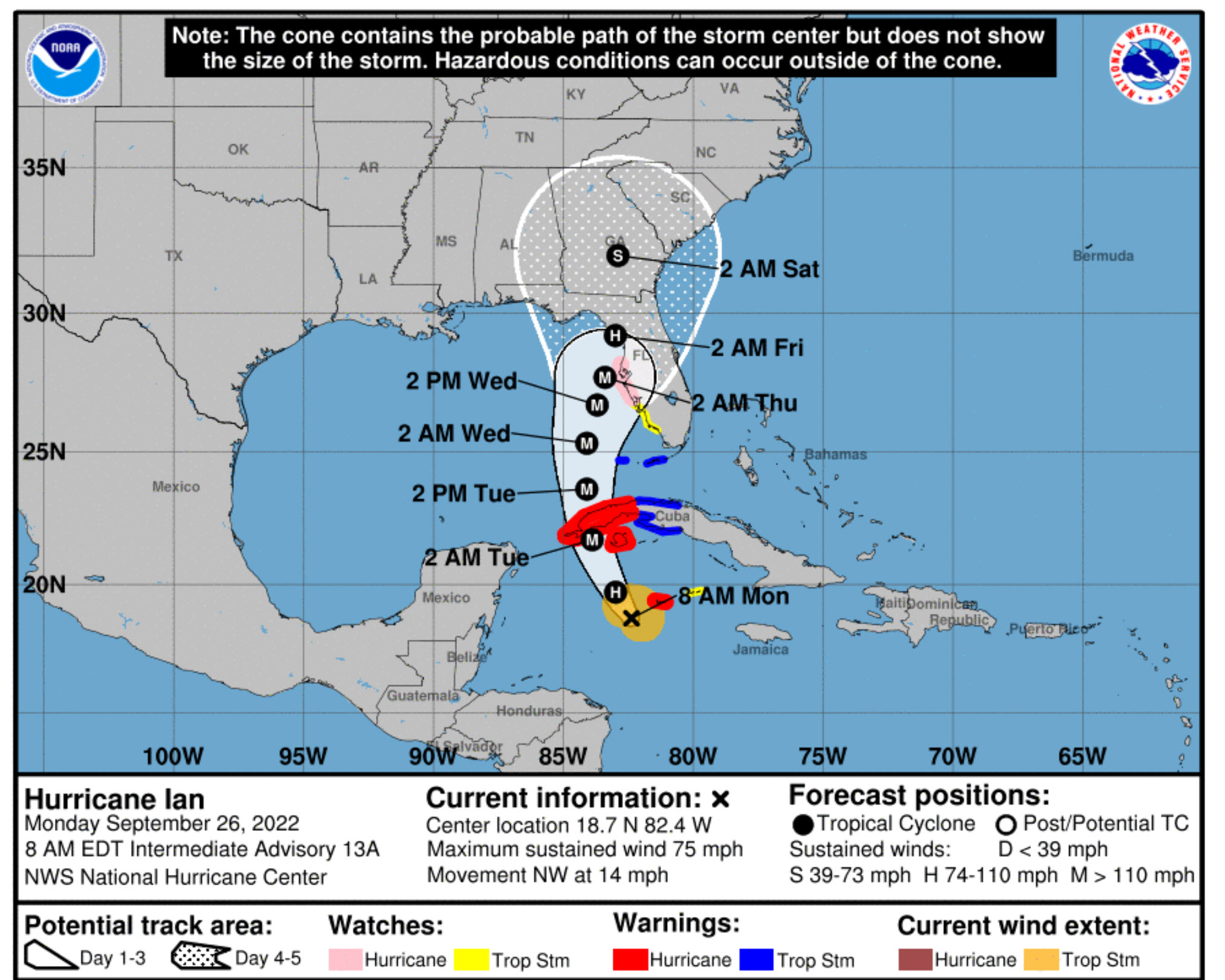
Data continues to merge on a final solution for the track of Hurricane Ian.
Ian strengthened to a hurricane overnight. It will continue to gain strength today and tomorrow. It is forecast to become a major hurricane.
Guidance continues to bring this system into Florida Tuesday through Friday.
It should be out of Florida (or mostly out of Florida) by Saturday and Sunday.
The worst of the weather conditions will be during the work week.
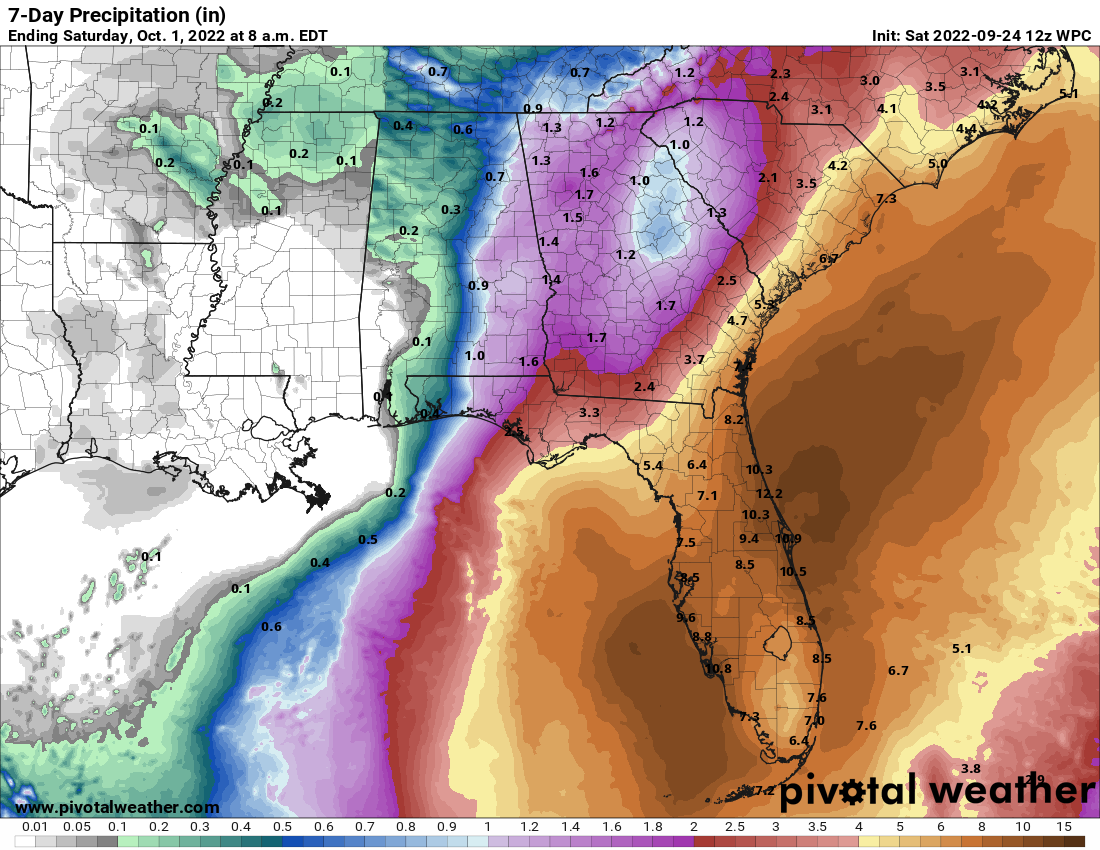
High wind, storm surge, flash flooding, and tornadoes will accompany this hurricane.
Guidance continues to show the system coming ashore somewhere from the Florida Panhandle south southeast towards west central Florida.
Remember, a hurricane is not a single point on a map. It is large and covers hundreds of miles.
The most severe conditions are usually northeast and east of the eye (center of the storm).
If you live in the impacted area, then follow local meteorologists.
If you area traveling southward, over the coming days, then make sure you are aware of updated weather conditions.
More information here
https://www.nhc.noaa.gov/refresh/graphics_at4+shtml/102341.shtml?cone#contents
Double click graphics to enlarge them
.
Saturday, September 24, 2022
Evening update. Saturday.
Saturday Night. September 24, 2022
I keep hammering this message.
The CONE, on this graphic, is where the CENTER of the storm may make landfall.
The center of a hurricane is called an eye. The eye of the hurricane.
The cone currently extends from the Florida Panhandle to south Florida.
Remember, that tropical storm and hurricane conditions will extend well outward from the eye. A hurricane is not a single point on a map.
This cone represents where the eye may come ashore.
If the eye comes ashore in the Florida Panhandle, then impacts may extend into Louisiana.
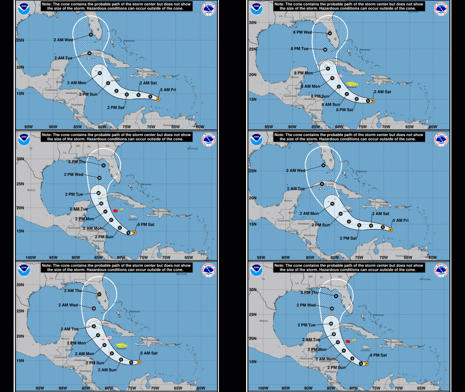
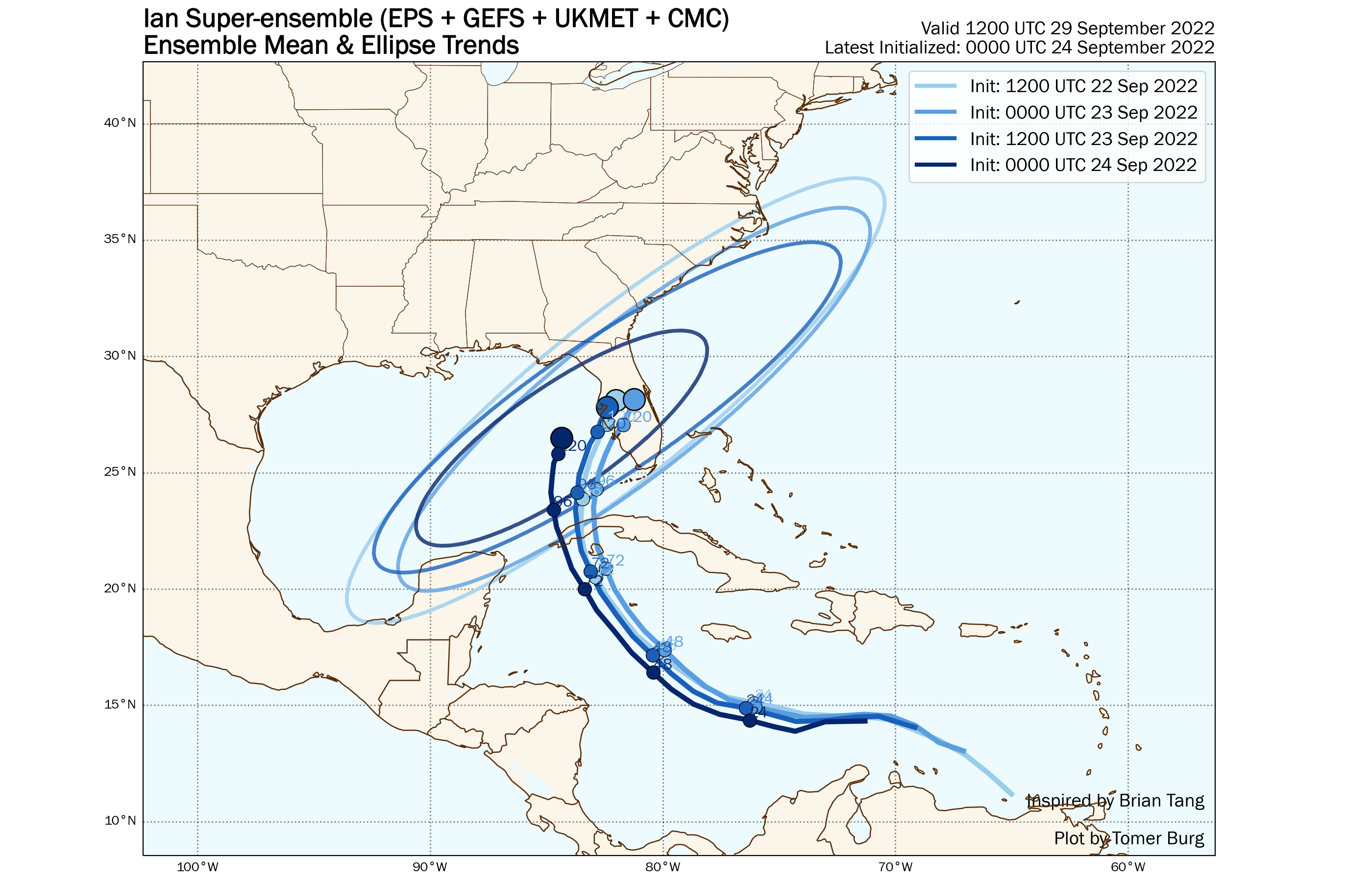
The center of this cone continues to TREND westward. That means that the odds of the eye hitting the panhandle continue to increase.
Trends are important when tracking a weather system. Trends tend to be slow. Over time, the trend distance accumulates.
Notice the trend on this animation. The cone is trending westward.
Double click on the animation to enlarge it.
If you have travel plans to the Gulf of Mexico, then you will want to monitor the forecast.
We still have several days to monitor this event.
Some impacts may begin, across portions of Florida, as early as Tuesday and continue into the week.
If you have questions, then ask me. beaudodson@usawx.com
Click here for more information from the National Hurricane Center.
.
Here is the latest information concerning Tropical Storm Ian.
Click here for more information from the National Hurricane Center.
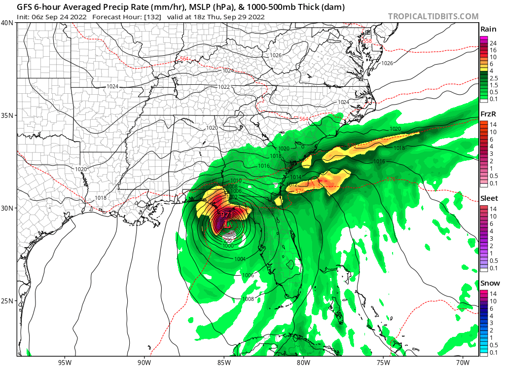
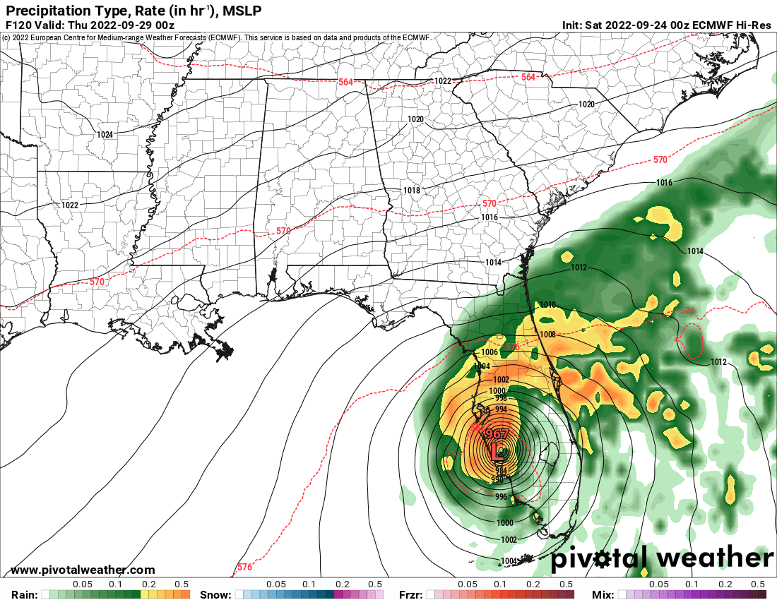
First, I am want to point out to you the differences in model guidance.
The GFS brings the hurricane ashore in the Florida Panhandle.
The European model brings it ashore in central Florida.
There remain disagreements in the data. Thus, monitor updates if you have travel plans.
The focus will be Tuesday onward.
The trend over the past 24 hours was to shift the highest probabilities for landfall slightly north and west. We need to see if this continues.
Do not focus on just the center of the cone. It is still possible that the storm comes ashore as far west as the Florida Panhandle.
The Florida Panhandle is still in the cone.
The cone is where the center could pass. You still have to deal with heavy rain, wind, and tornadoes well away from the center.
For example, if Ian makes landfall in the Florida Panhandle, then rain and wind would spread as far west as Louisiana, Mississippi, and Alabama.
Key Points.
1. The system is now a tropical storm and is expected to become a hurricane.
2. The cone showing possible landfall (where the eye/center will pass) remains large.
3. The system may slow as it approaches and moves across Florida. This would cause lingering impacts through much of next week. This remains a question.
Those with travels plans should monitor updates.
Impacts are possible in Florida as early as Tuesday. That would be the first rain-bands and wind.
Conditions would deteriorate from there onward.
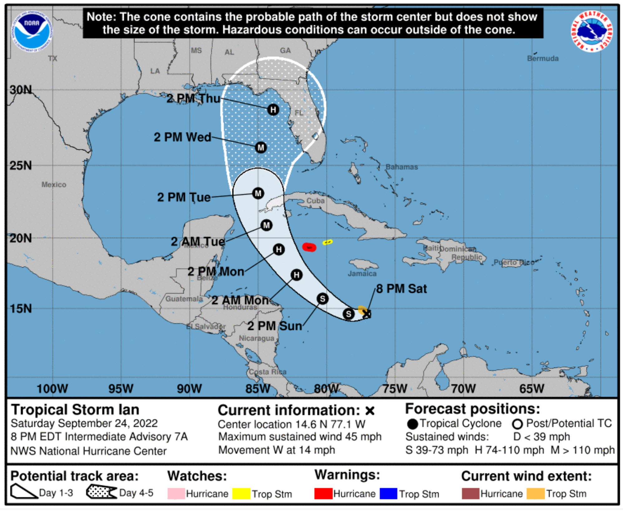
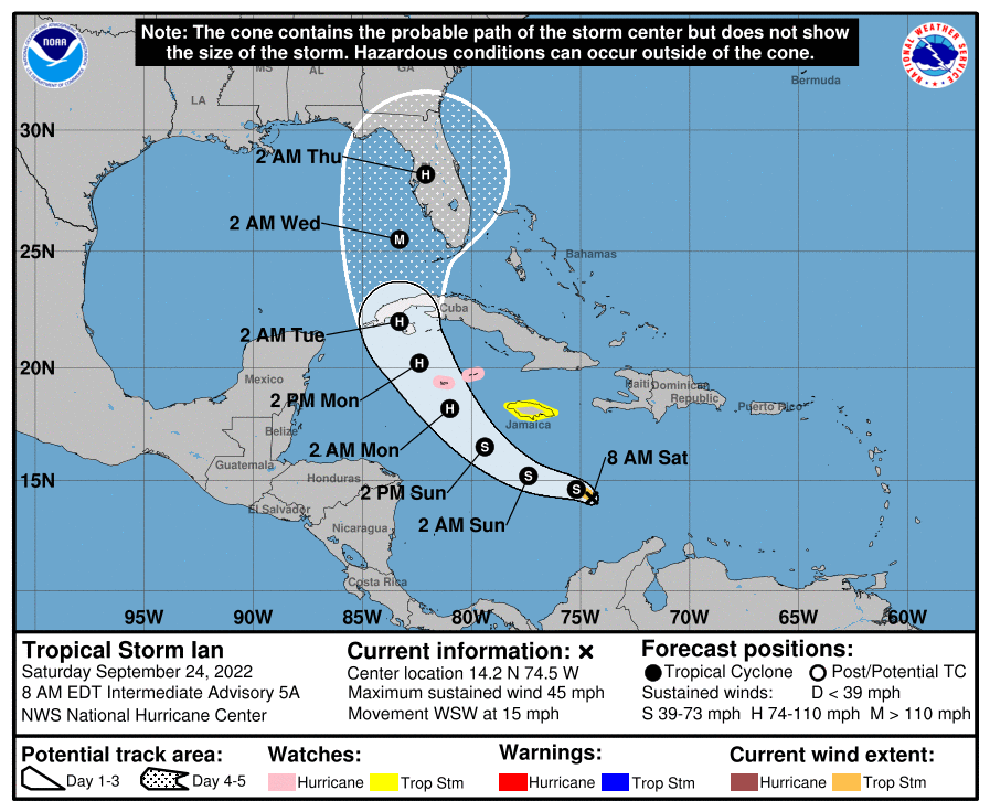
This graphic shows you the potential path of the eye of the storm. Remember, a hurricane is not a point on the map.
Rain bands will spread outward hundreds of miles. Heavy rain, flooding, gusty wind, and tornadoes can occur well away from the eye.
This map shows you the current forecast path.
This system is still developing and adjustments are possible.
Typically, the worst weather conditions are on the east and northeast side of a landfalling tropical system.
Ian is forecast to become a hurricane.
Currently, landfall in Florida is forecast to be next Tuesday, Wednesday, Thursday, and Friday.
Some models show it stalling/slowing over Florida. Stay tuned.
Follow the National Hurricane Center’s advisories here https://www.nhc.noaa.gov/
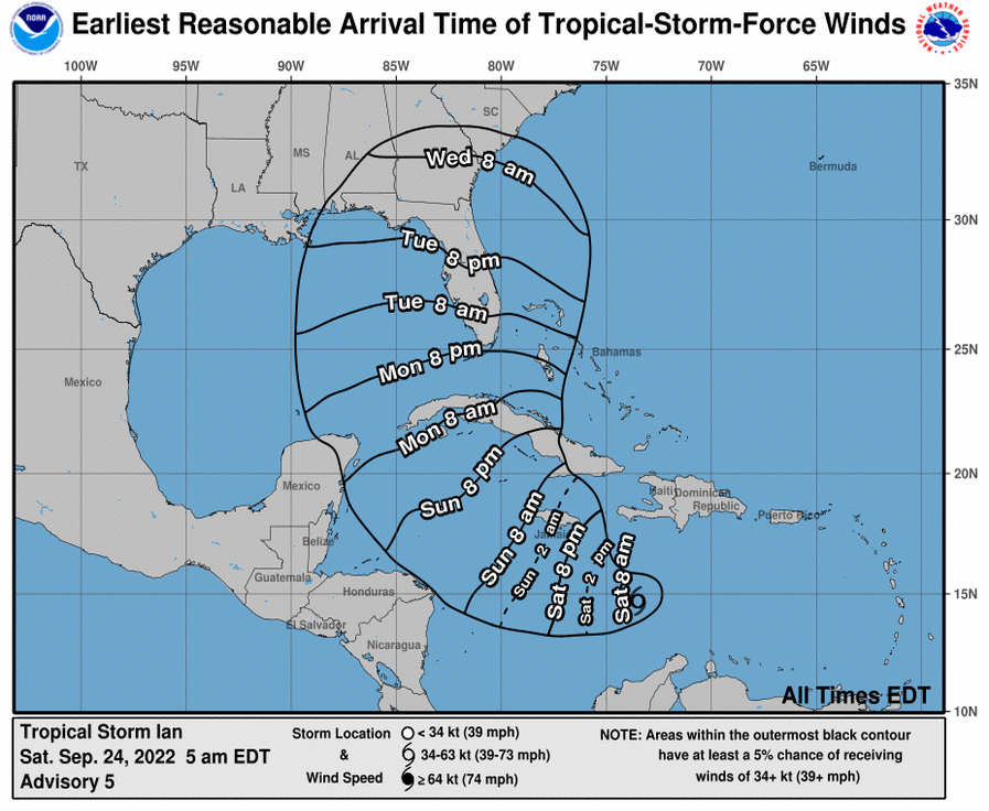
Possible arrival time of tropical storm force winds.
Winds would continue beyond this time-frame. This is simply the arrival time of the beginning of the wind.
Trends.
.


The app is for subscribers. Subscribe at www.weathertalk.com/welcome then go to your app store and search for WeatherTalk
Subscribers, PLEASE USE THE APP. ATT and Verizon are not reliable during severe weather. They are delaying text messages.
The app is under WeatherTalk in the app store.
Apple users click here
Android users click here
.

Radars and Lightning Data
Interactive-city-view radars. Clickable watches and warnings.
https://wtalk.co/B3XHASFZ
If the radar is not updating then try another one. If a radar does not appear to be refreshing then hit Ctrl F5. You may also try restarting your browser.
Backup radar site in case the above one is not working.
https://weathertalk.com/morani
Regional Radar
https://imagery.weathertalk.com/prx/RadarLoop.mp4
** NEW ** Zoom radar with chaser tracking abilities!
ZoomRadar
Lightning Data (zoom in and out of your local area)
https://wtalk.co/WJ3SN5UZ
Not working? Email me at beaudodson@usawx.com
National map of weather watches and warnings. Click here.
Storm Prediction Center. Click here.
Weather Prediction Center. Click here.
.

Live lightning data: Click here.
Real time lightning data (another one) https://map.blitzortung.org/#5.02/37.95/-86.99
Our new Zoom radar with storm chases
.
.

Interactive GOES R satellite. Track clouds. Click here.
GOES 16 slider tool. Click here.
College of Dupage satellites. Click here
.

Here are the latest local river stage forecast numbers Click Here.
Here are the latest lake stage forecast numbers for Kentucky Lake and Lake Barkley Click Here.
.
.
Find Beau on Facebook! Click the banner.




 .
.