Friday, January 3, 2025
5:00 PM
I posted this video for everyone. Facebook and subscribers. Ignore the ad at the beginning.
Here is the latest
.
2:04 PM
The winter storm watch has been extended into Monday.
WINTER STORM WATCH IN EFFECT FROM LATE SATURDAY NIGHT THROUGH
LATE SUNDAY NIGHT...

* WHAT...Heavy mixed precipitation possible. Total snow and sleet
  accumulations 4 inches or more and ice accumulations of one
  quarter inch or more are possible.

* WHERE...Portions of southern Illinois, southwest Indiana, western
  Kentucky, and southeast Missouri, generally north of a line from
  Ellsinore to Cape Girardeau Missouri and on to Golconda Illinois
  and Greenville Kentucky.

* WHEN...From late Saturday night through late Sunday night.

* IMPACTS...Power outages and tree damage are possible due to the
  ice. Travel could be nearly impossible. The hazardous conditions
  could impact the Monday morning commute.

PRECAUTIONARY/PREPAREDNESS ACTIONS...

Monitor the latest forecasts for updates on this situation.
2:00 PM Update
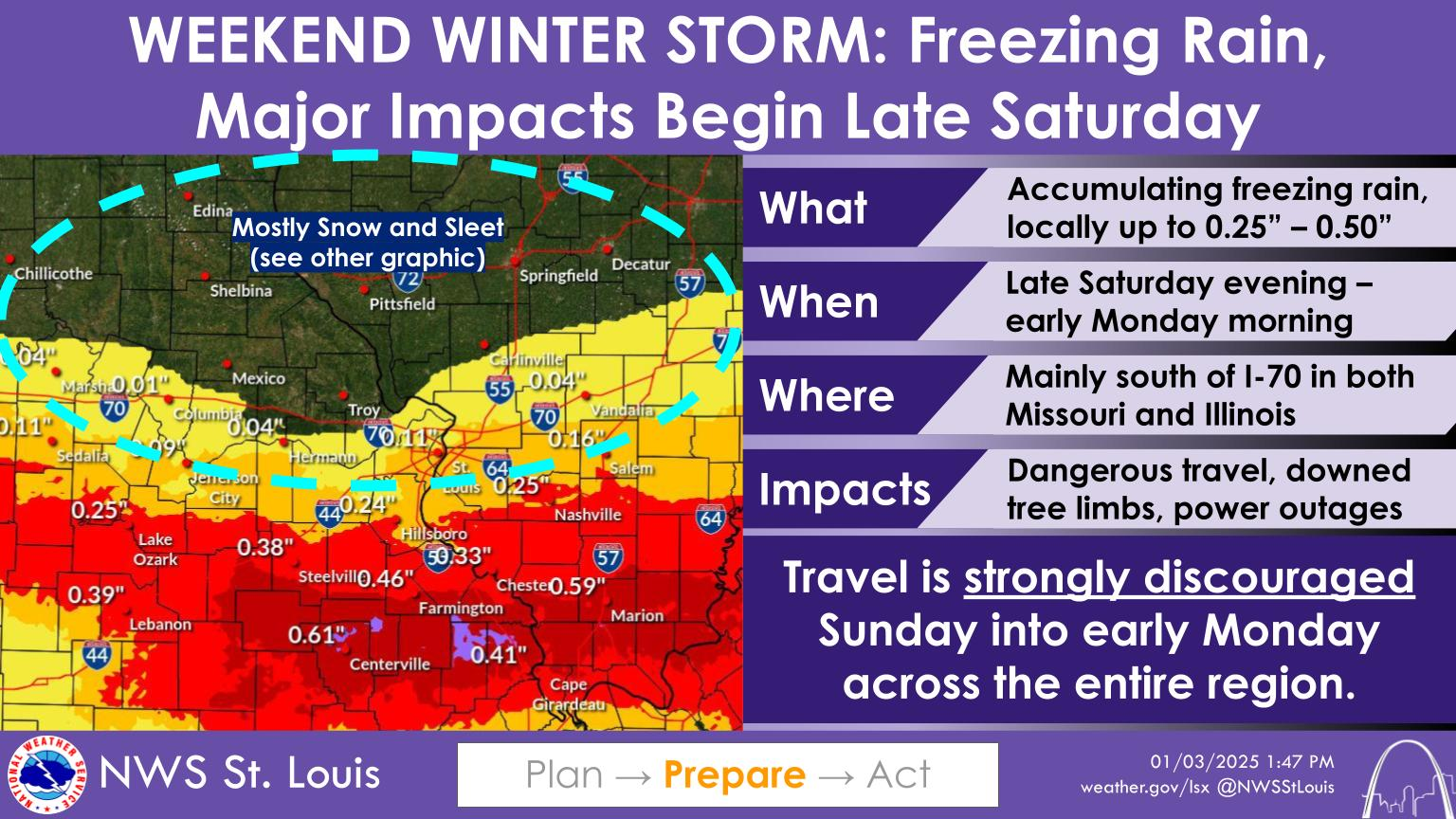
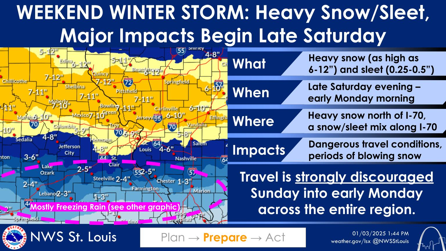
Updated graphics from the St Louis, MO NWS
Double click an image to make it larger
1:43 PM Update
Winter Storm Warning
Ste Genevieve and Randolph Counties.
Including the cities of Farmington, Sparta, and Chester
129 PM CST Fri Jan 3 2025
WINTER STORM WARNING IN EFFECT FROM 10 PM SATURDAY TO 6 AM CST
MONDAY…
WHAT…Heavy mixed precipitation expected. Total snow and sleet
accumulations between 2 and 4 inches and ice accumulations between
two tenths and one half of an inch.
WHERE…In Illinois, Randolph IL County. In Missouri, Crawford MO,
Washington MO, Saint Francois MO, and Sainte Genevieve MO Counties.
WHEN…From 10 PM Saturday to 6 AM CST Monday.
IMPACTS…Power outages and tree damage are likely due to the ice.
Travel could be nearly impossible. The hazardous conditions could
impact the Monday morning commute.
PRECAUTIONARY/PREPAREDNESS ACTIONS…
If you must travel, keep an extra flashlight, food, and water in
your vehicle in case of an emergency. In Illinois, the latest road
conditions can be obtained at www.gettingaroundillinois.com. In
Missouri, the latest road conditions can be obtained at
traveler.modot.org/map or by calling 1-888-275-6636.
12:19 PM
A New Winter Storm Watch has been issued (the old one remains in effect, as well)
12:15 PM
The NWS in Paducah, Kentucky has added more counties to the winter storm watch.
National Weather Service Paducah KY
1201 PM CST Fri Jan 3 2025
Counties added
IL: Alexander-Pulaski-Massac County
KY: Ballard-McCracken-Livingston-Marshall-Lyon-Trigg-Caldwell-Christian-Todd County
MO: Scott County
Including the cities of Elkton, Wickliffe, Benton, Mound City, Metropolis, Cadiz, Sikeston, Hopkinsville, Cairo, Paducah, Princeton, Eddyville, and Smithland
WINTER STORM WATCH IN EFFECT FROM LATE SATURDAY NIGHT THROUGH
LATE SUNDAY NIGHT…
WHAT…Heavy mixed precipitation possible. Total snow and sleet
accumulations of 4 inches or more and ice accumulations of one
quarter inch or more are possible.
WHERE…Portions of southern Illinois, western Kentucky, and
southeast Missouri.
WHEN…From late Saturday night through late Sunday night.
IMPACTS…Power outages and tree damage are likely due to the ice.
Travel could be nearly impossible. The hazardous conditions could
impact the Monday morning commute.
PRECAUTIONARY/PREPAREDNESS ACTIONS…
Monitor the latest forecasts for updates on this situation.
The previous winter storm watch remains in effect, as well.
IL: Jefferson-Wayne IL-Edwards-Wabash-Perry IL-Franklin-Hamilton-
White-Jackson-Williamson-Saline-Gallatin-Union-Johnson-Pope-
Hardin
IN: Gibson-Pike-Posey-Vanderburgh-Warrick-Spencer County
KY: Crittenden-Union KY-Webster-Hopkins-Henderson-Daviess-McLean-Muhlenberg County
MO: Perry MO-Bollinger-Cape Girardeau-Wayne MO-Carter County
Including the cities of Greenville, Petersburg, Fairfield,
Vienna, Calhoun, Carbondale, Golconda, Shawneetown, Henderson,
Rockport, Jackson, Morganfield, Murphysboro, Owensboro, Herrin,
Jonesboro, Poseyville, Mount Carmel, Pinckneyville, Marble Hill,
Mount Vernon, Evansville, Albion, Harrisburg, Marion, Dixon, Fort
Branch, Madisonville, Cape Girardeau, Perryville, Van Buren,
Elizabethtown, Carmi, Boonville, West Frankfort, Piedmont, and
McLeansboro
1201 PM CST Fri Jan 3 2025 /101 PM EST Fri Jan 3 2025/
WINTER STORM WATCH REMAINS IN EFFECT FROM LATE SATURDAY NIGHT
THROUGH LATE SUNDAY NIGHT…
WHAT…Heavy mixed precipitation possible. Total snow and sleet
accumulations 4 inches or more and ice accumulations of one
quarter inch or more are possible.
WHERE…Portions of southern Illinois, southwest Indiana, western
Kentucky, and southeast Missouri.
WHEN…From late Saturday night through late Sunday night.
IMPACTS…Power outages and tree damage are likely due to the ice.
Travel could be nearly impossible. The hazardous conditions could
impact the Monday morning commute.
PRECAUTIONARY/PREPAREDNESS ACTIONS…
Monitor the latest forecasts for updates on this situation.
11:15 AM
Here are some NWS graphics.
Keep in mind, I expect additional adjustments to these graphics. The ice and snow could be farther south than shown here. Depending on storm track.
Double click on the graphic to enlarge it
11 AM Update
No real change in the GEFS model this morning. It is a bit south from yesterday. Every mile counts. If it shifts much more south, then ice will need to come farther south.
I expect another row or two of counties to be added to the winter storm watch.
I expect a winter weather advisory for much of the area Saturday night/Sunday morning (south of the watch zone).
I expect winter storm warnings and ice storm warnings to be issued by tonight or tomorrow morning. The NWS will do that, of course.
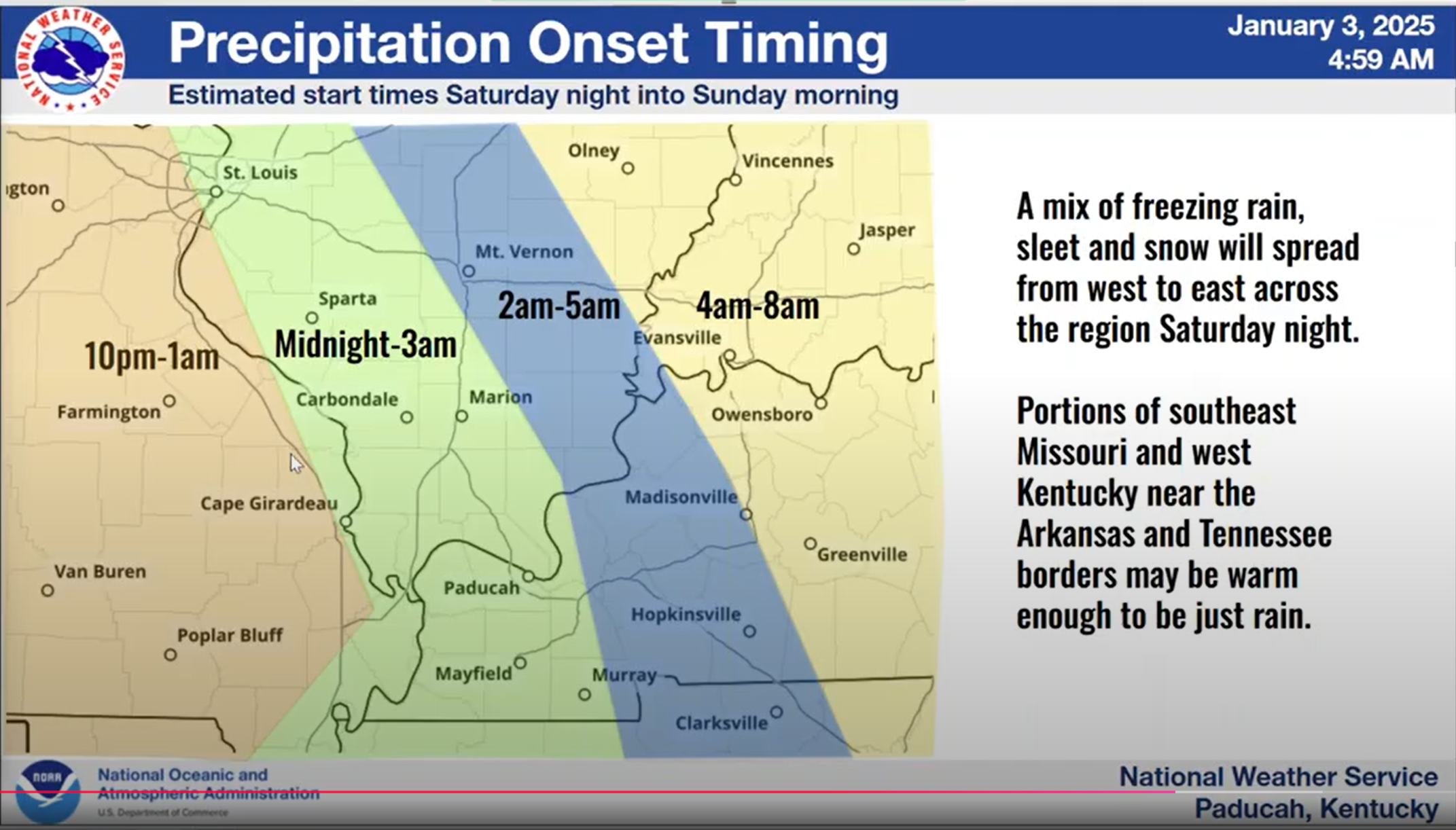
Timing graphic for a wintry mix
9:30 AM
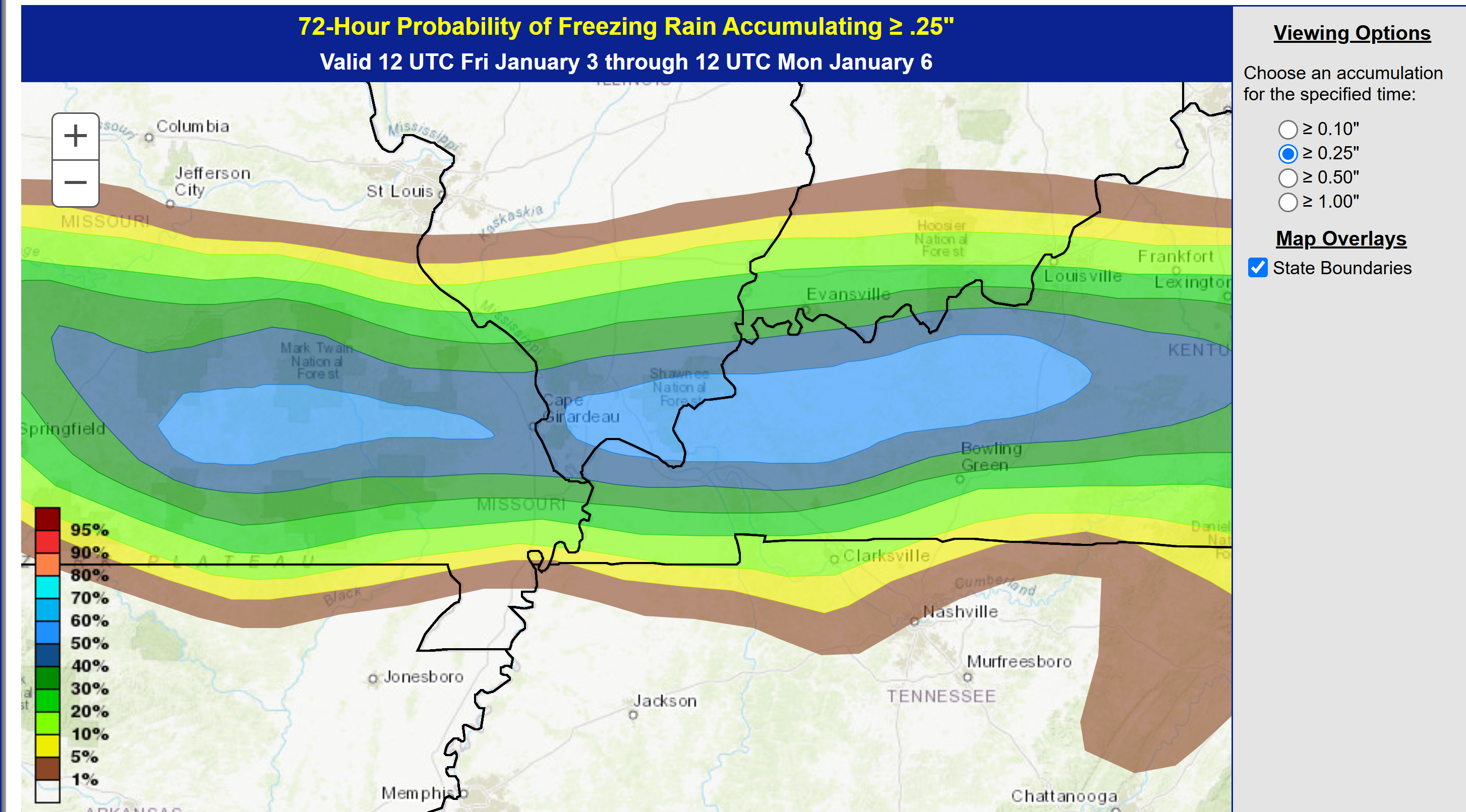
WPC is a bit farther south with some of their ice accumulation maps.
This would mean more counties would need to be added to the winter storm watch or ice storm warning.
Something worth monitoring.
This lines up with what I have been saying all morning. A couple of row of counties is too close to call on rain vs freezing rain.
Here is their map showing the probability of 0.25″ or more of freezing rain accumulating on surfaces.
9:00 AM
I am waiting on the GFS model ensembles to come in. I am watching for any shifts in the low track.
I will know more in an hour or so.
I have a NWS conference call at 10:30 AM. I will report back on that, as well.
The NAM model came in about the same as previous.
It also shows the battle line being near the OH River. Too close to call for some counties. Meaning, whether you change to all rain or stay ice.
8:00 AM Update
7:40 AM Update
Right now, I am looking at a two or three county wide zone of question marks. That would be where I drew that pink line on the graphic below.
The system is still moving ashore so models don’t sample it all that well. Not until it comes ashore later today.
There were shifts in all the data southward and colder.
That raises questions about the counties south of the winter storm watch. Additional counties may need to be added. Or, an advisory.
An ice storm warning will be needed for portions of the region.
For now, the pink zone is the big question mark. Does it change to plain old rain or stay ice. Tough forecast. Plan on ice and prepare accordingly. Hope the freezing line shifts north and changes you to plain old rain.
7:00 AM Update
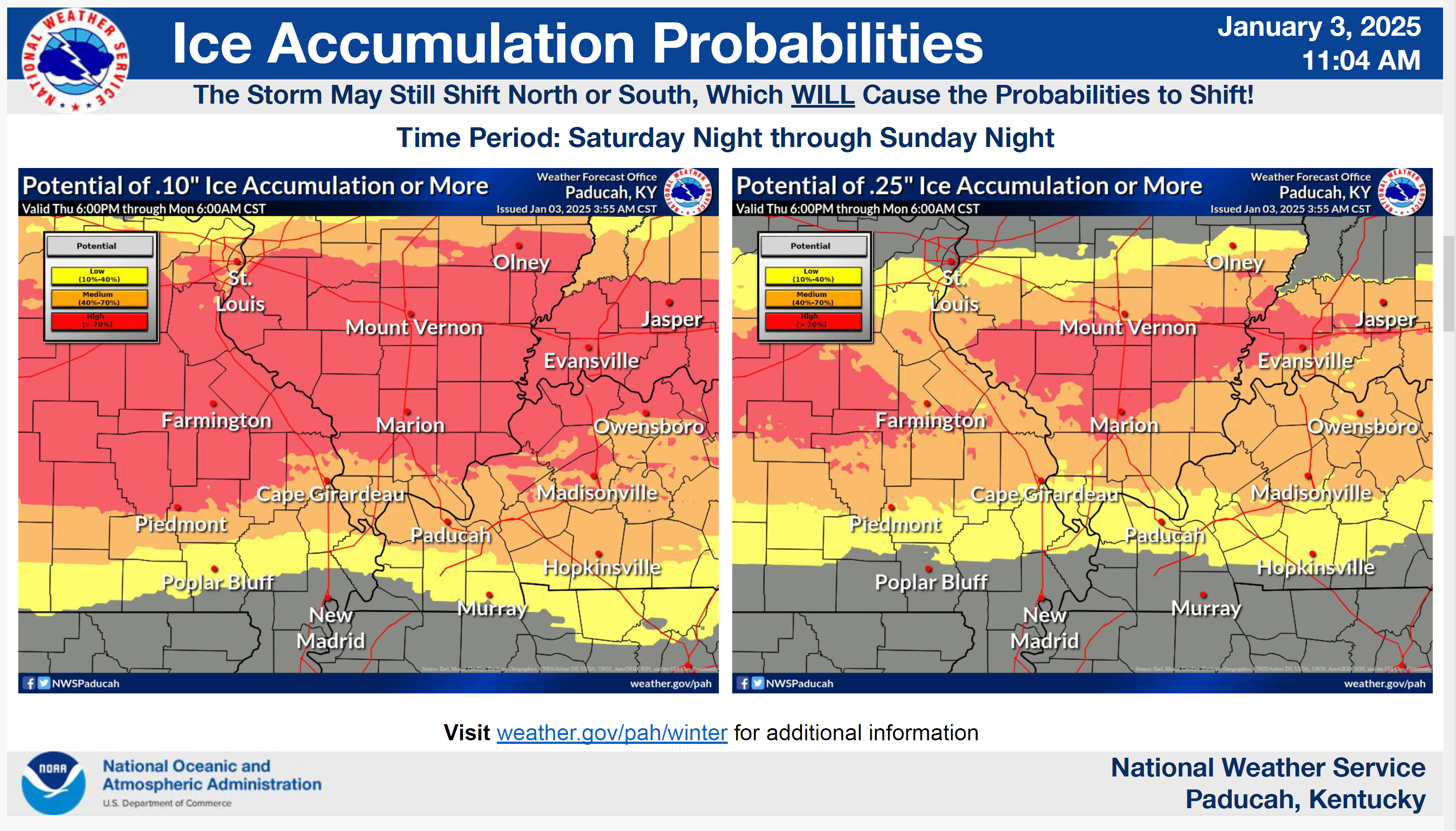
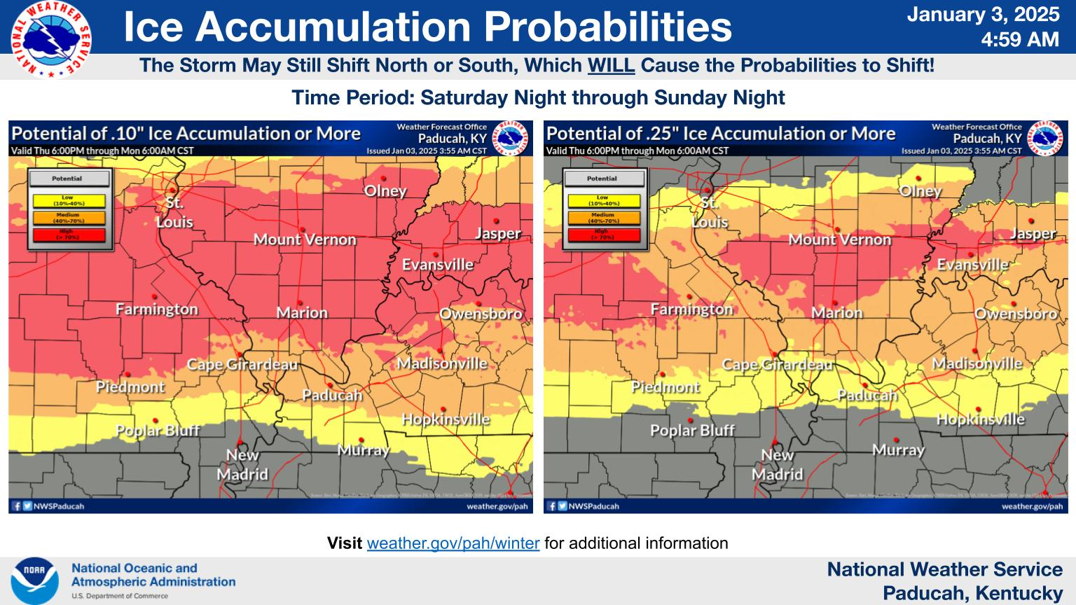
Here are some NWS graphics. Some shifts are still likely.
Double click images to enlarge them.
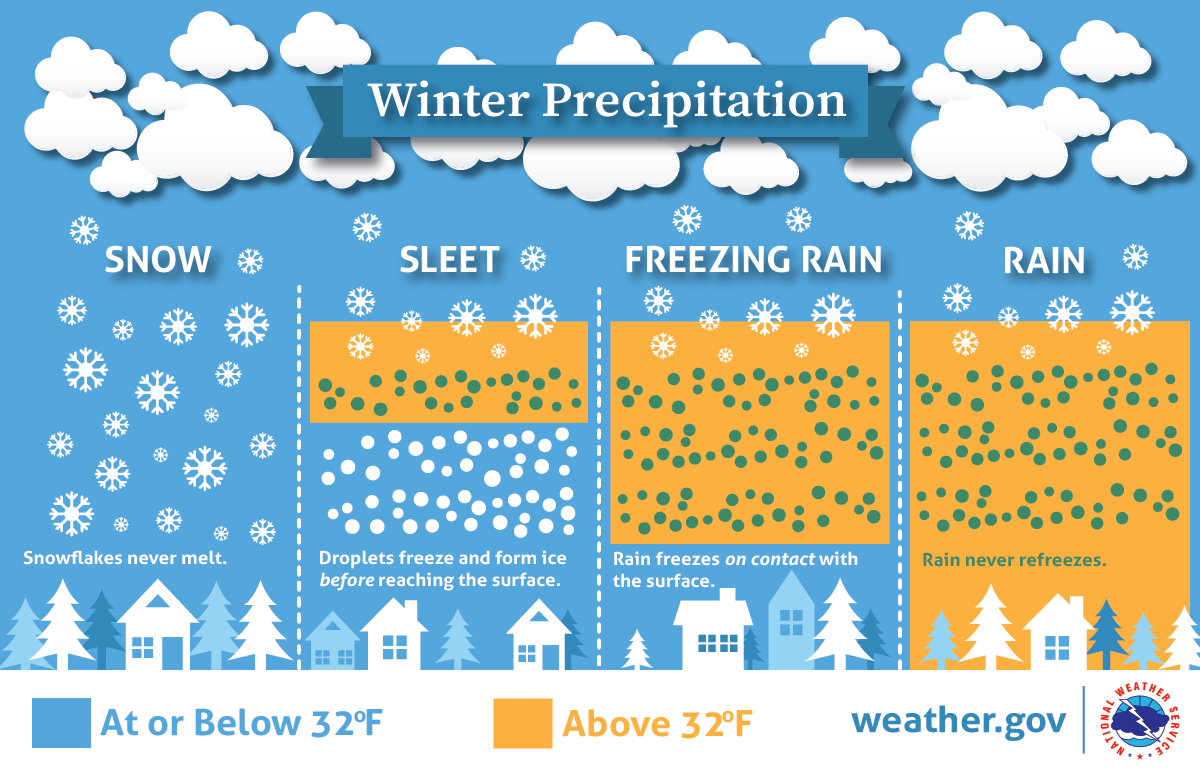
What is the potential for 0.10″ or 0.25″ of freezing rain. Freezing rain is what brings down power lines. Sleet are little ice pellets.
These graphics are freezing rain. Adjustments and shifts are likely.
6:10 AM
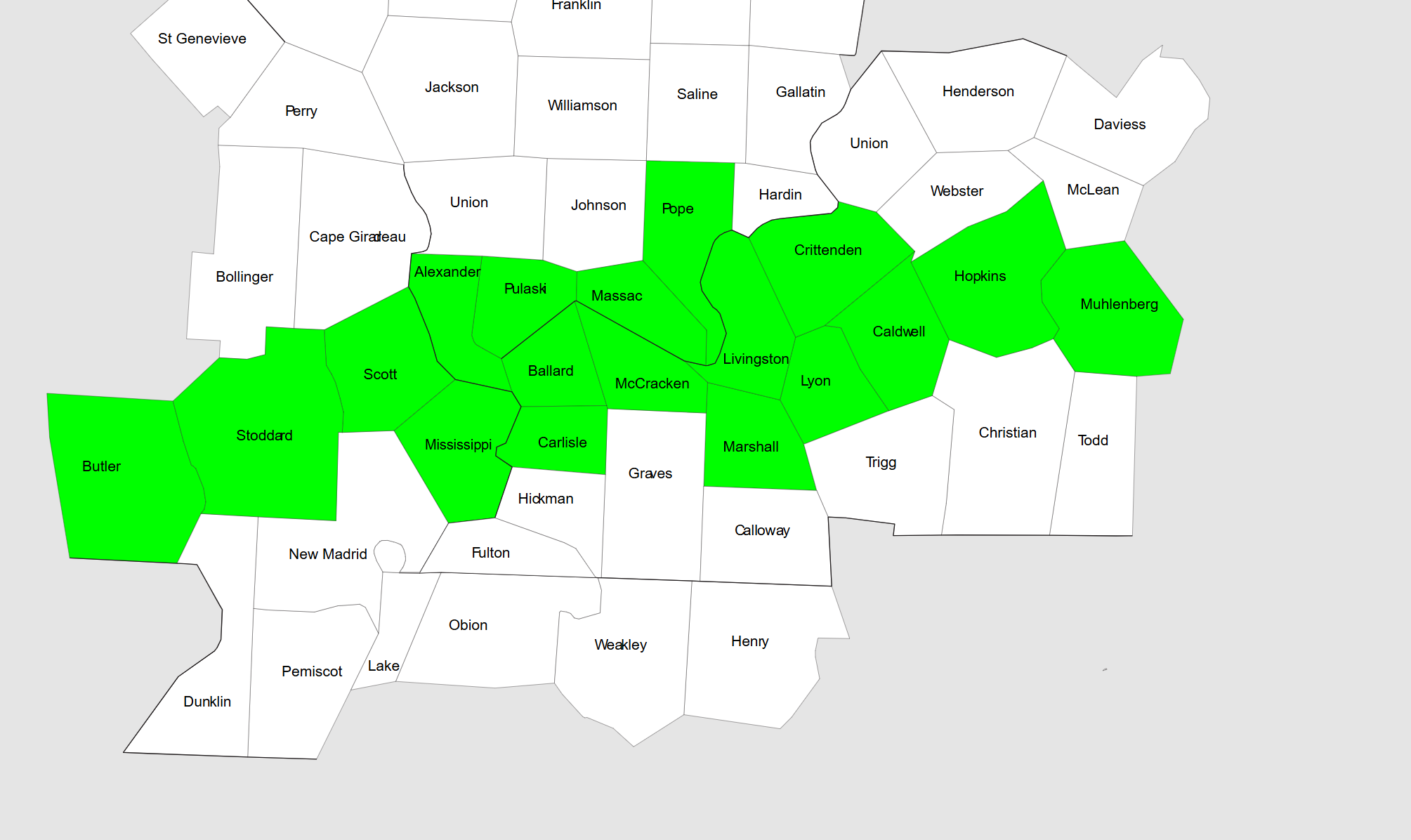
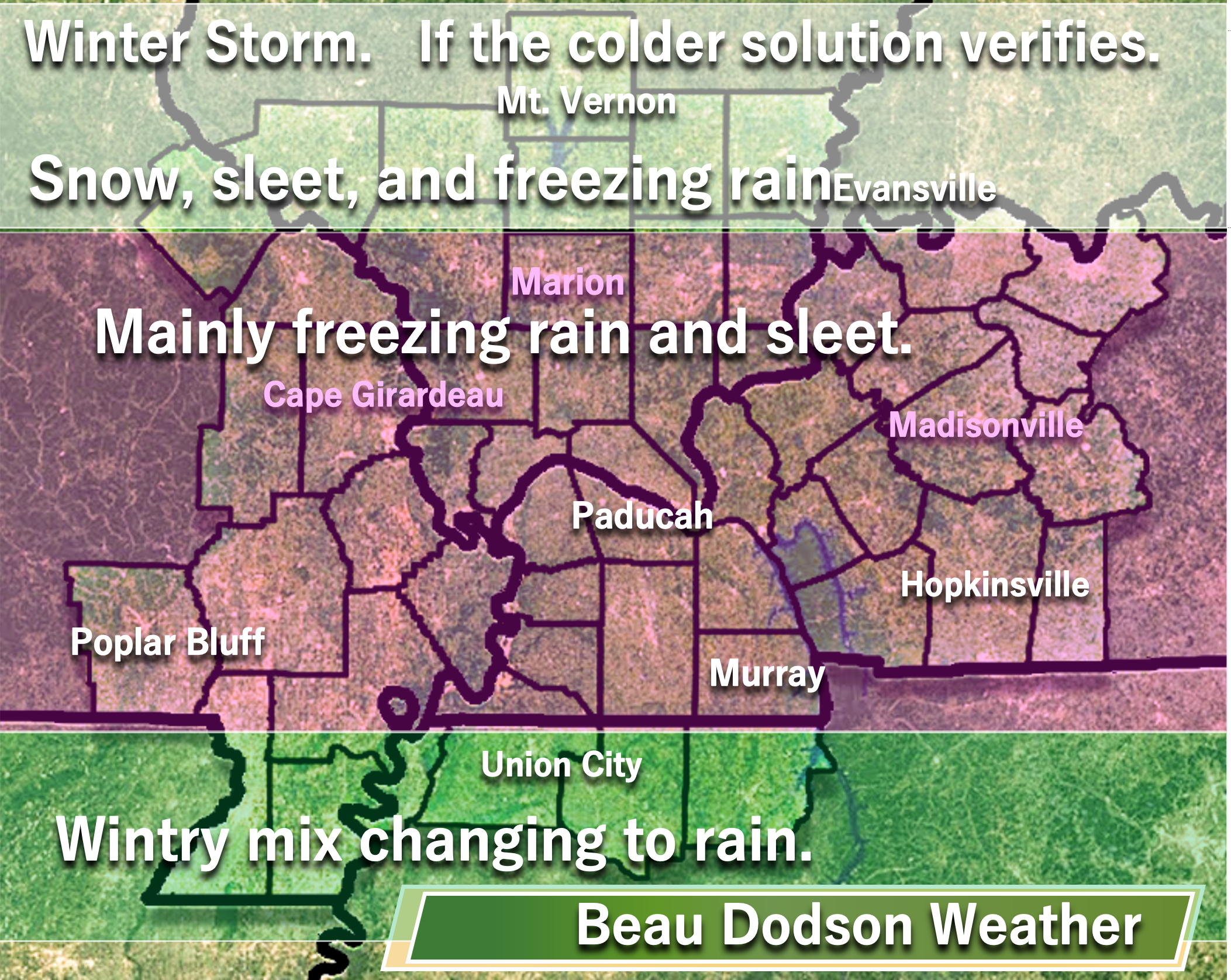
My concern right now are these counties. Perhaps the storm ends up a bit colder. That would mean more ice in these areas.
The winter storm watch would need to be pushed farther south, if the colder models verify. Pope and Crittenden are already in the winter storm watch.
If the colder models verify then this pink zone area could end up with more ice. This will need to be monitored.
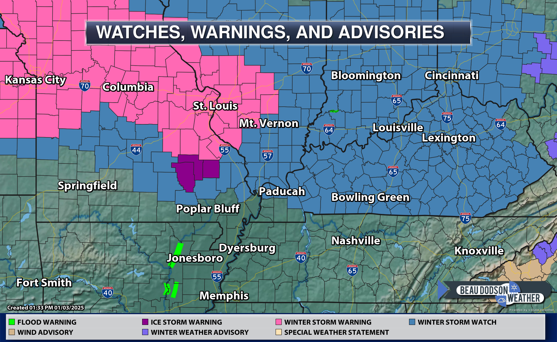
Blue counties are already in the winter storm watch.
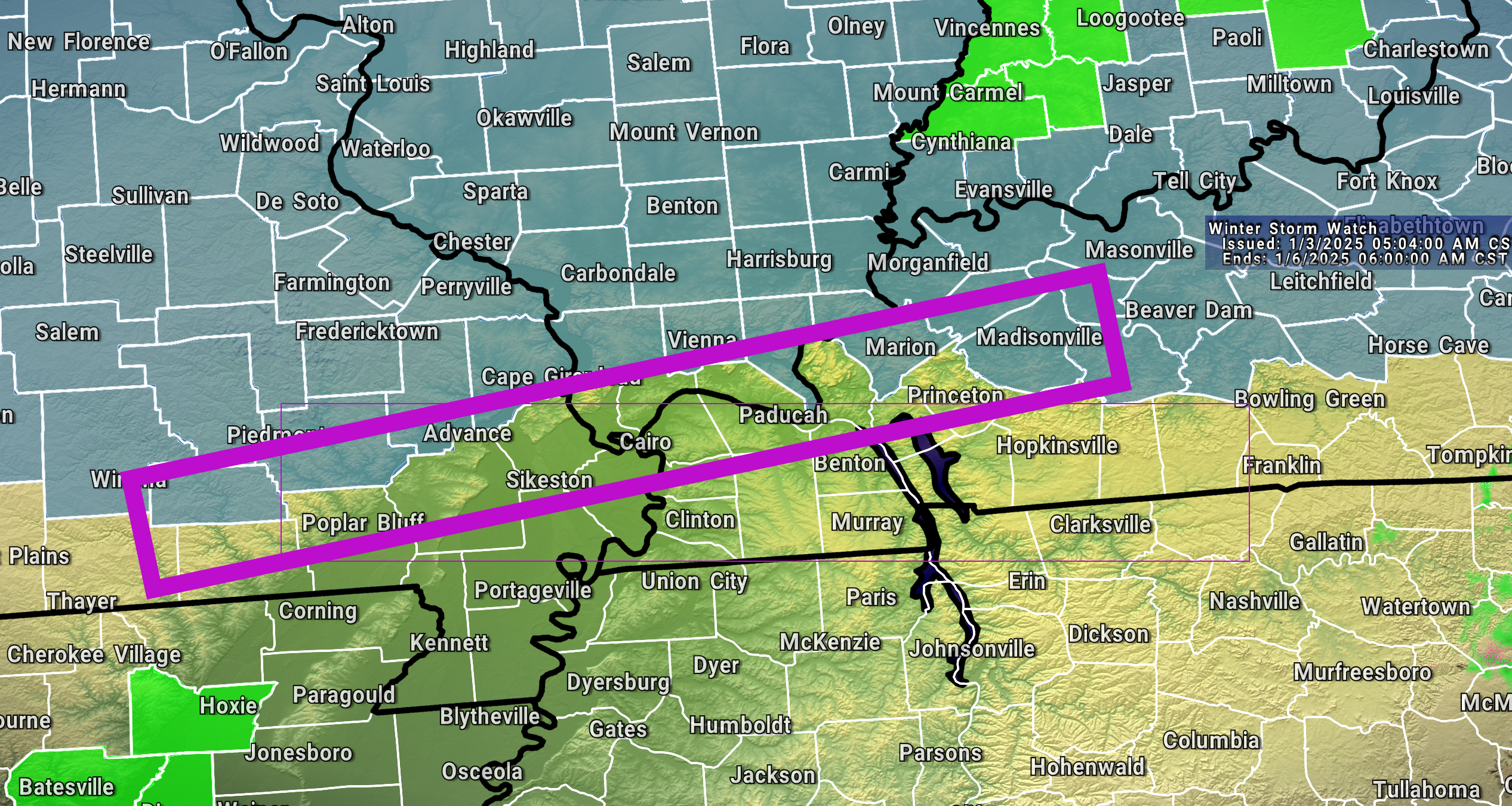
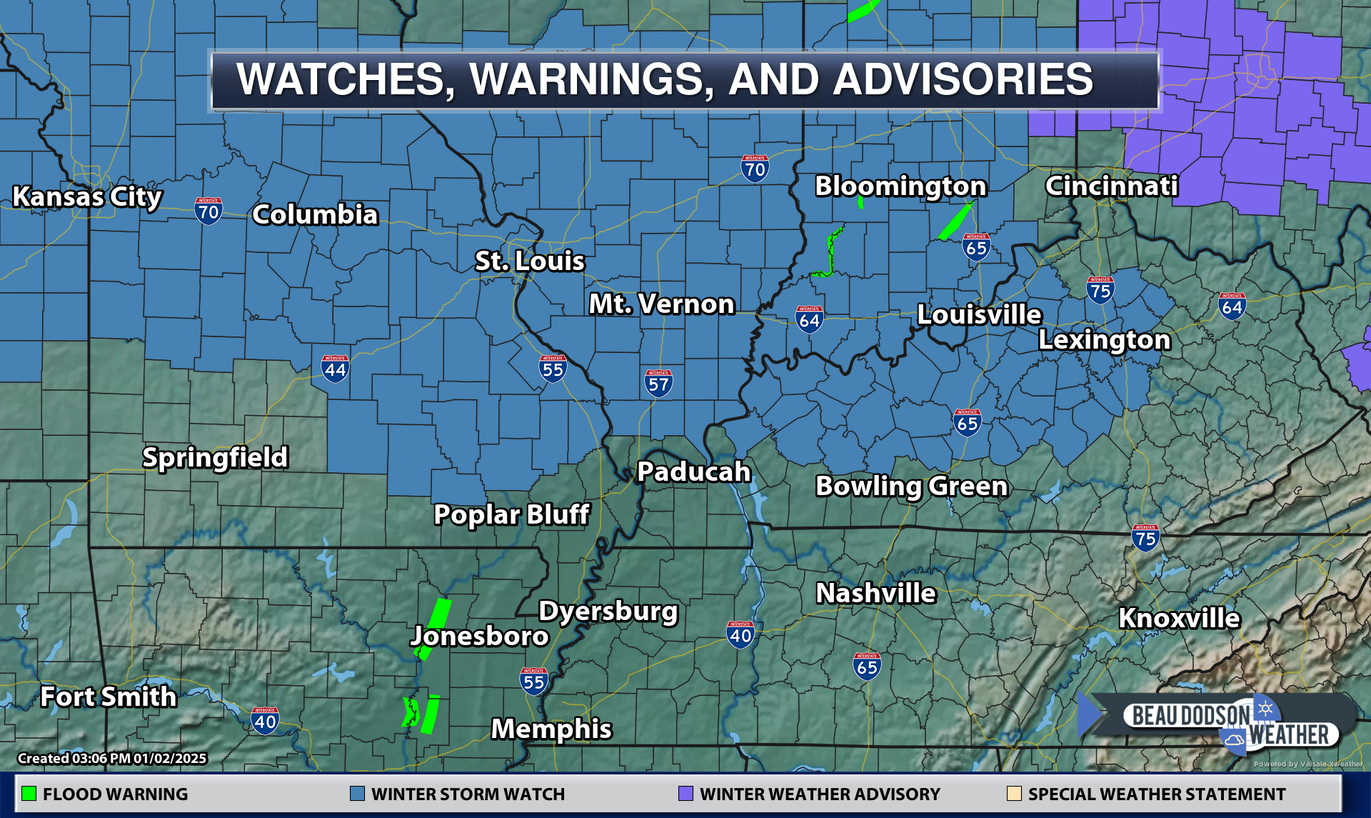
Here is another view of the current watch
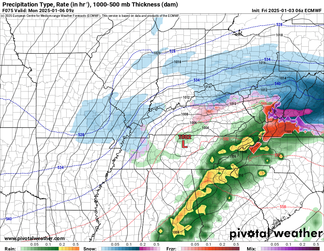
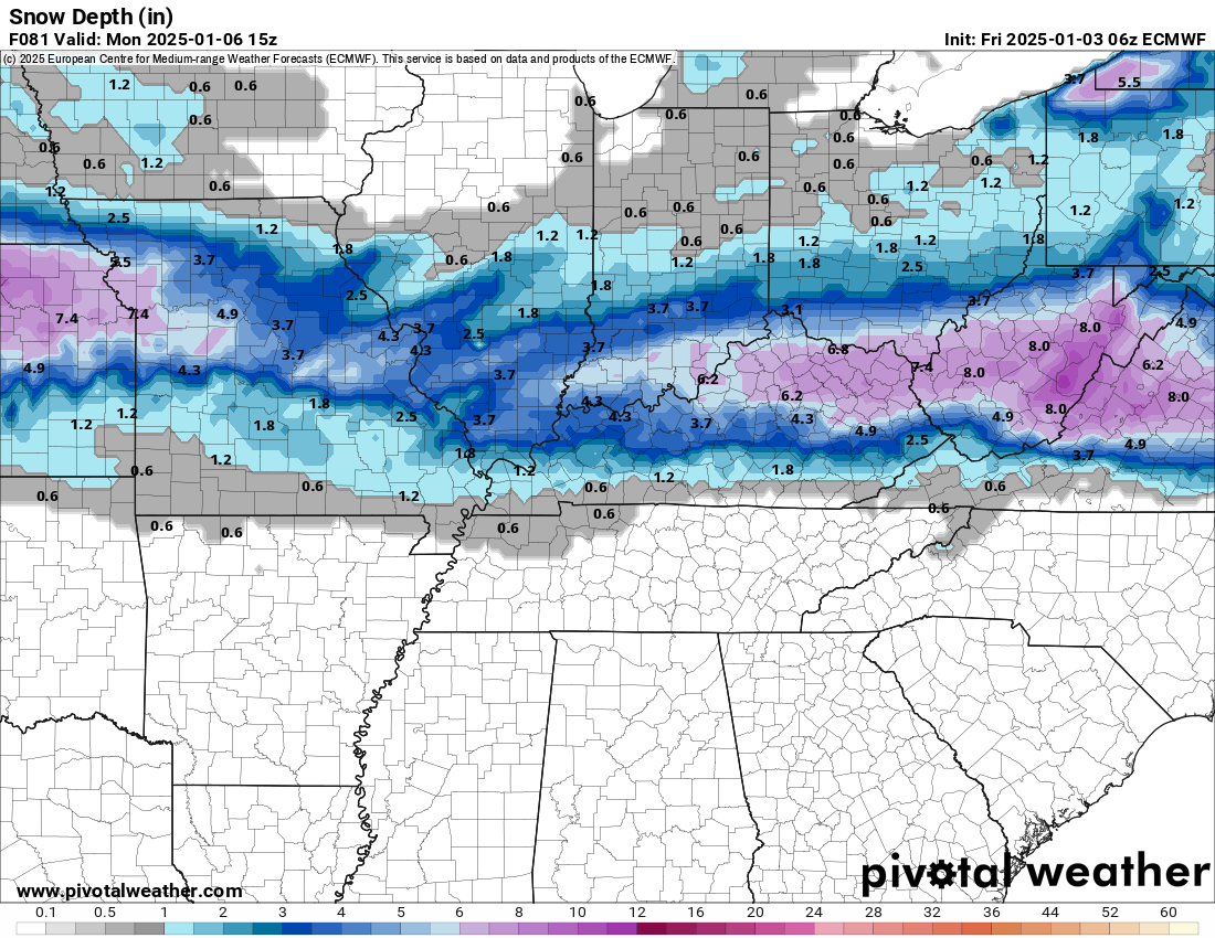
There could be some back end snow with this system. We call that wrap-around snow.
You can see that on this image.
The EC model is bullish for snow. We will have to watch the backside of the system.
Perhaps a quick one to three inches in some counties Sunday night and Monday morning.
5:53 AM
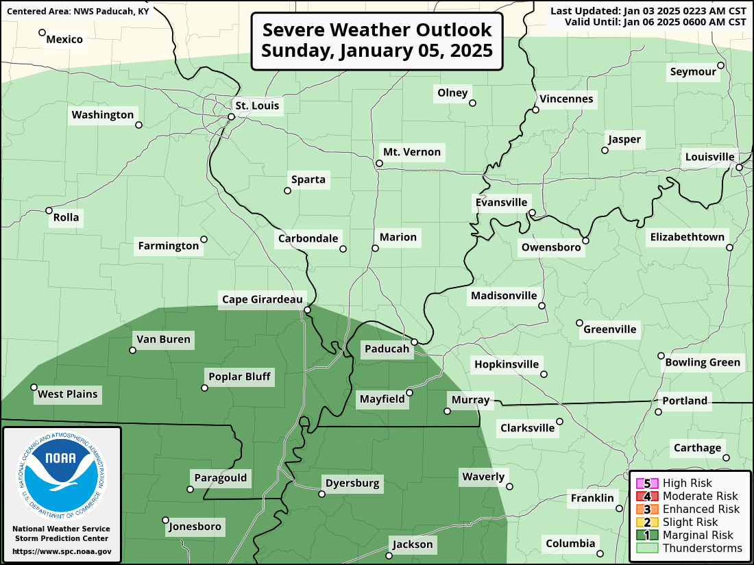
Something of interest. The Storm Prediction Center moved the marginal risk of severe thunderstorms farther north.
I am a little skeptical of this, but this is the area they outlined. Light green is where lightning is possible. My going forecast has been for thundersnow thundersleet/freezing rain, as well.
There could be lightning in the cold sector.
The dark green is where they believe some storms could produce damaging wind. Let’s monitor this, but I think they are too far north with this.
.
5:24 AM
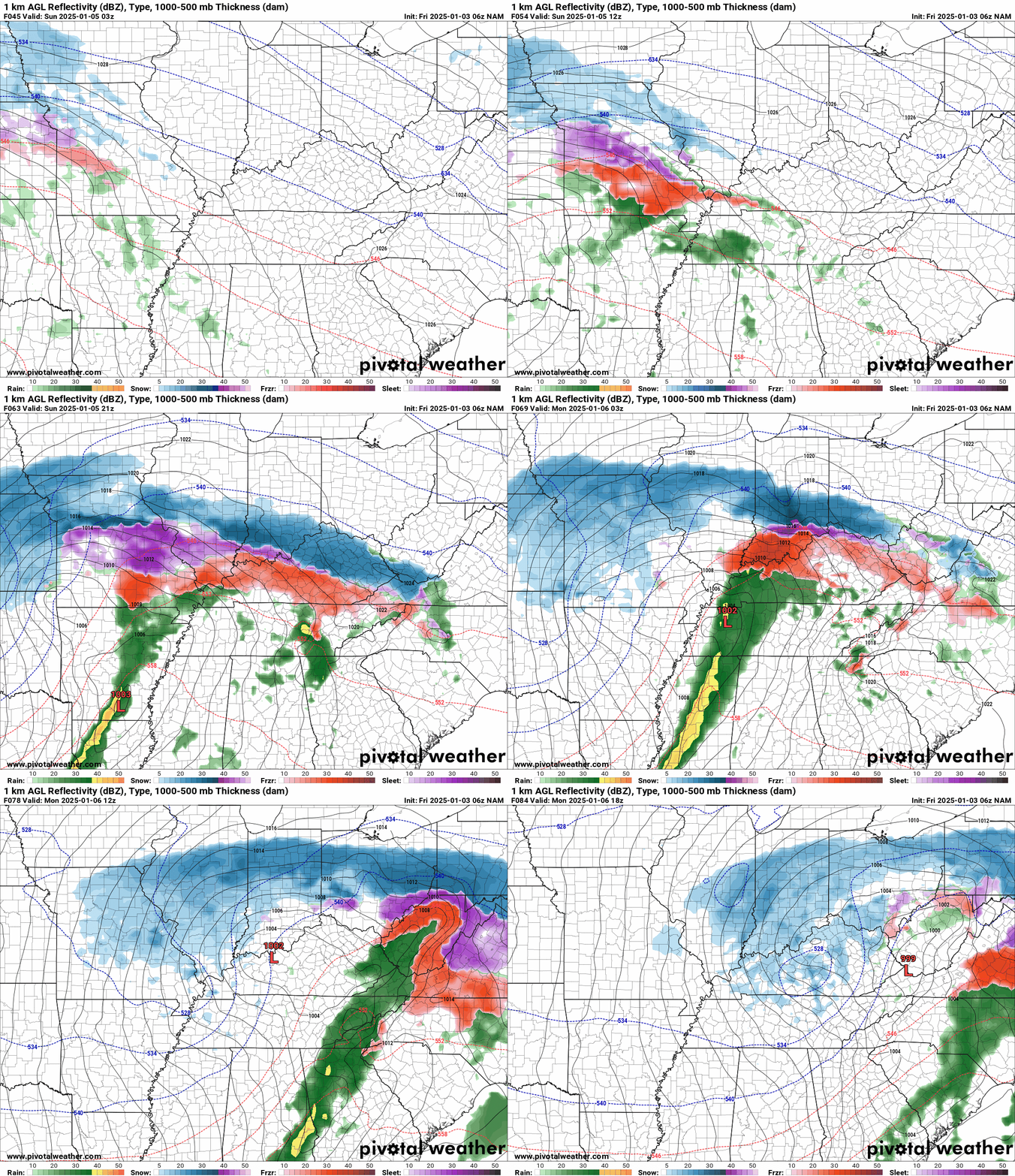
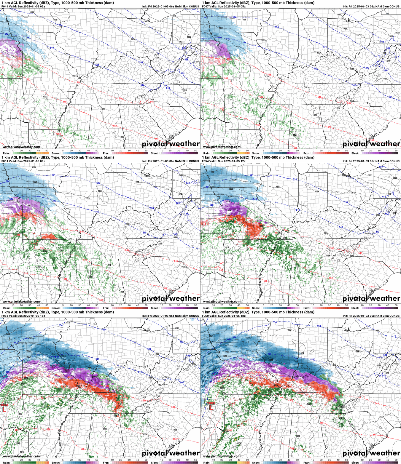
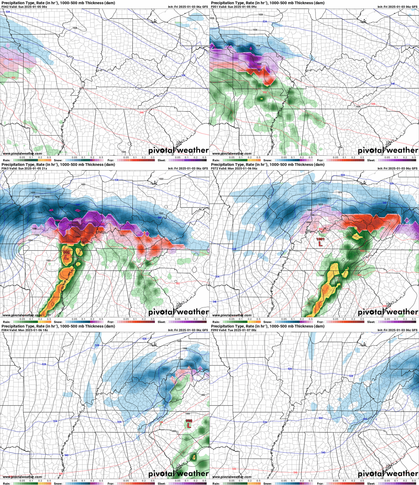
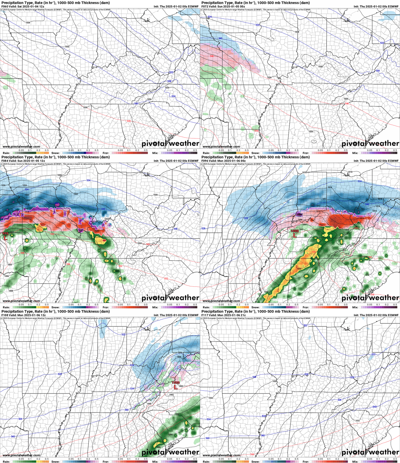
Here is some model data. Blue is snow. Purple is sleet. Red is freezing rain. Green is rain. Yellow is moderate rain.
Time stamp upper left (in Zulu time). 12z=6 am. 18z=12 pm. 00z=6 pm.
NAM model
NAM 3K model. Does not quite capture the entire storm, yet. It will later today.
GFS model
The track of the low is key to your forecast.
If this low tracks farther south, then the ice will be farther south. It is a close call for several row of counties.
The EC model trended slightly south overnight. Meaning, colder temperatures over our region.
The GEFS trended south, as well.
5:00 AM
Watch for several updates over the next hour.
There are two model solutions for this system.
The most likely one is this.
There are some models that are trending farther south. If the farther south solution verifies, then it will be colder with ice farther south.
It would look like this.
Thursday, January 2, 2025
next updates will be tomorrow morning
.
4:54 PM Update
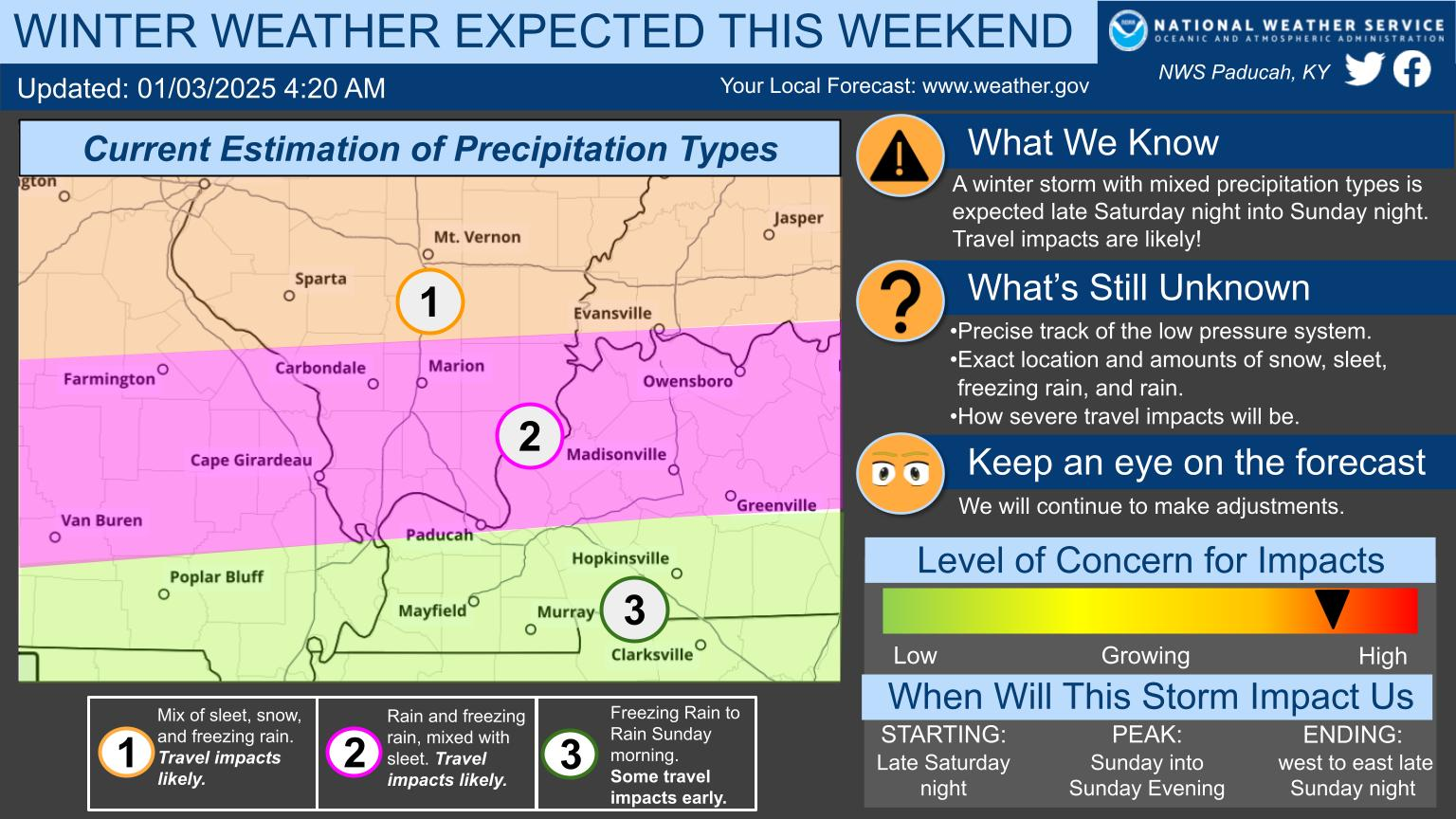
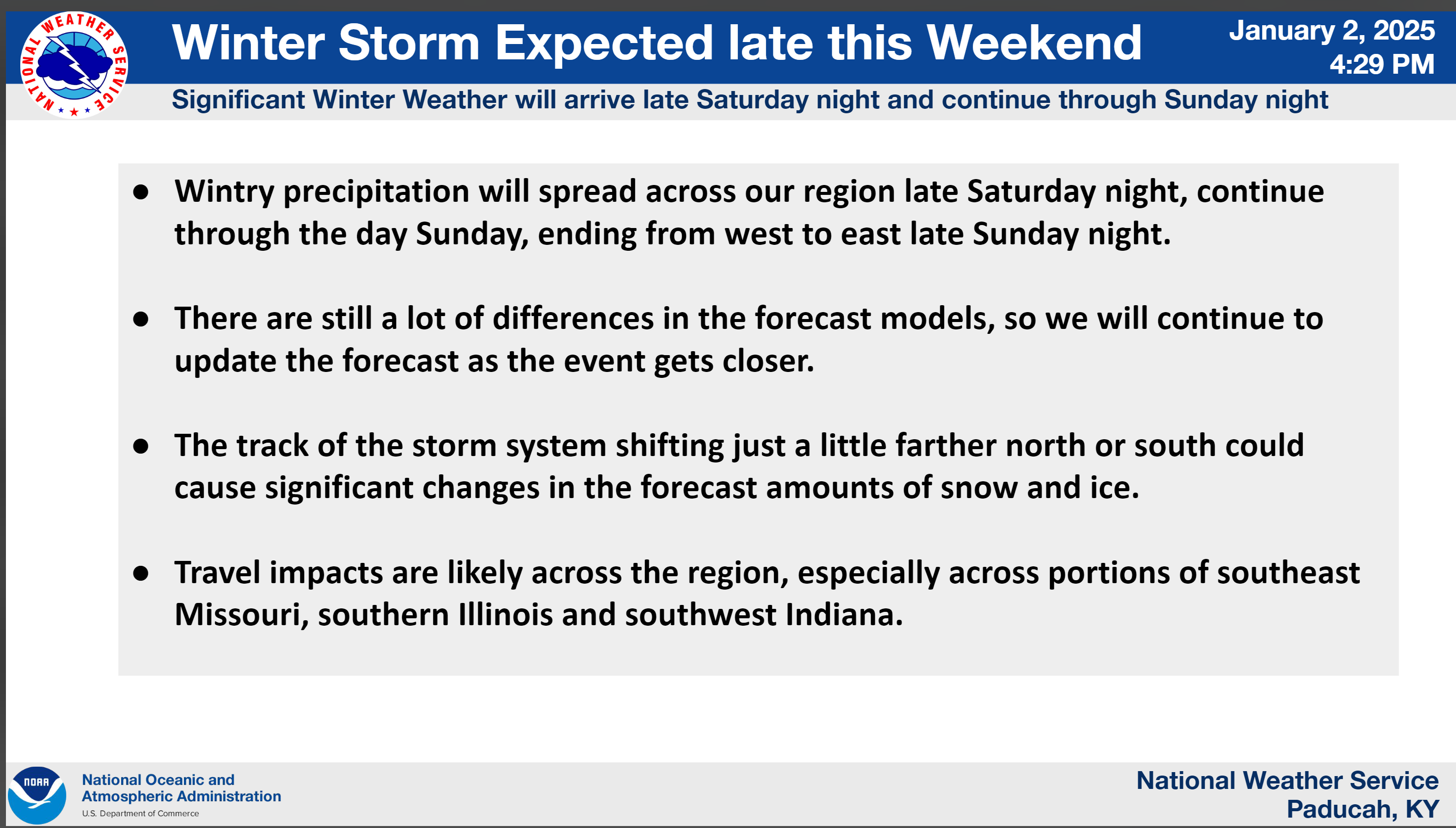
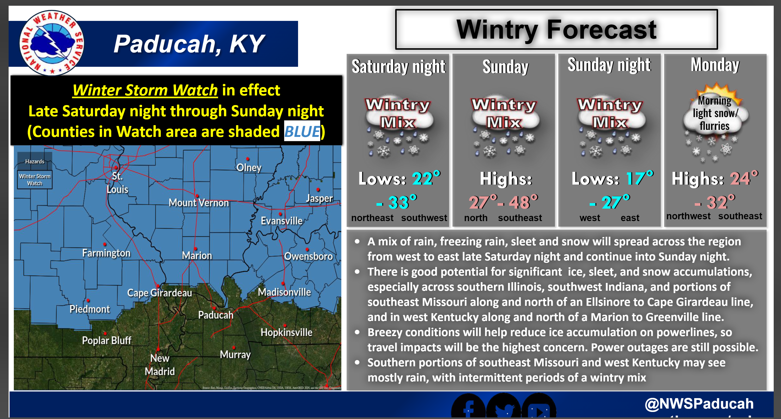
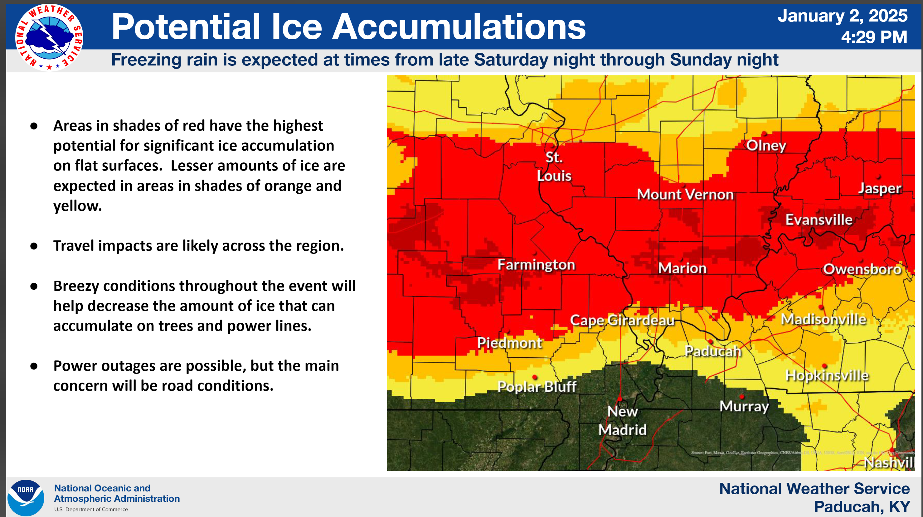
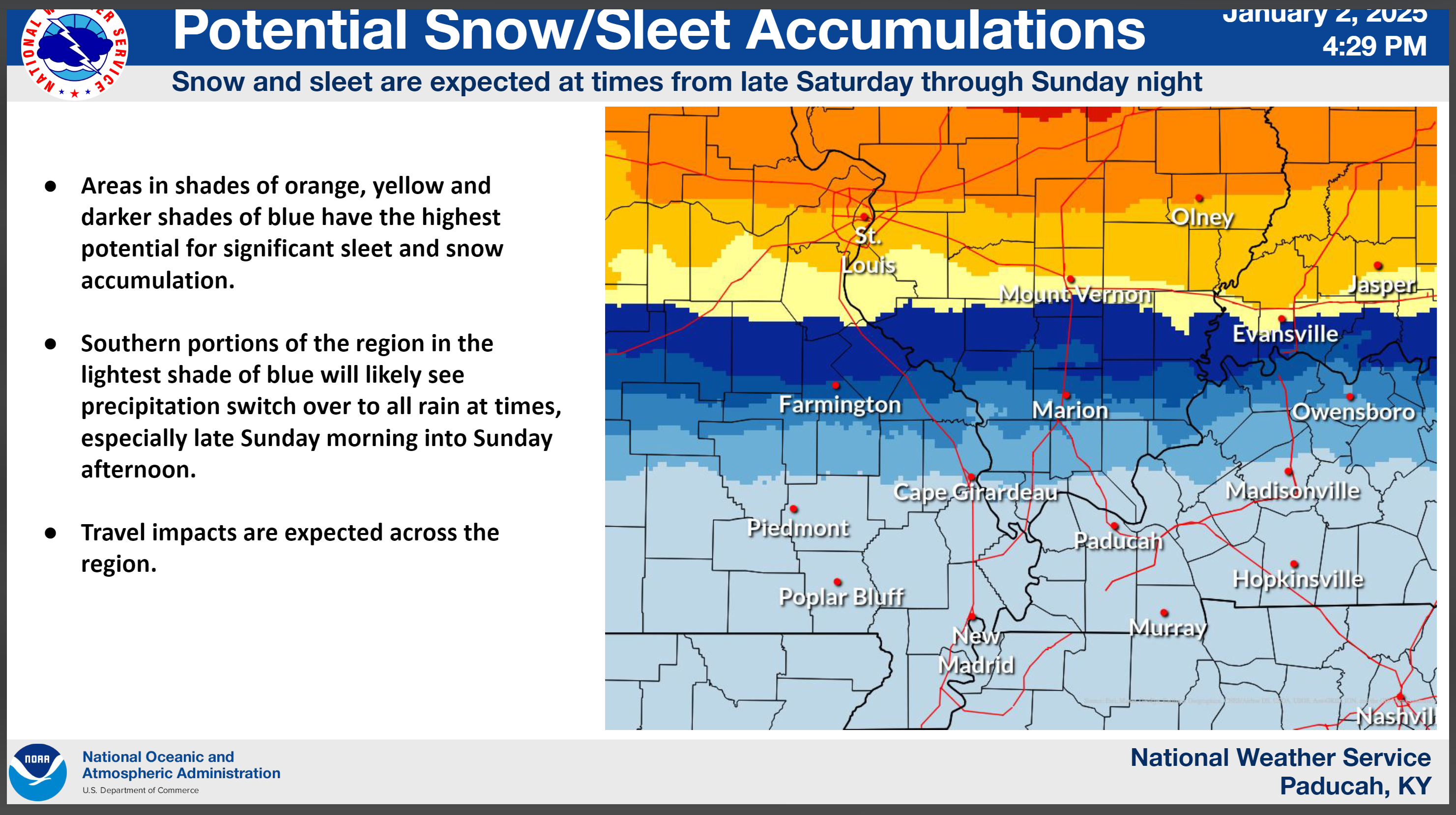
Some updated graphics from the Paducah, KY, NWS
REMEMBER
Counties south of the blue winter storm watch will also have icy roadways SAT night and SUN morning. An advisory may be issued for those areas.
3:21 PM
Here is a briefing from the St Louis, MO NWS Office
This covers Ste Genevieve and Randolph Counties. They cover that area. Although, they touch on other counties, as well.
.
3:15 PM Update
Additional northern counties have been added to the winter storm watch.
Areas south of the blue winter storm box could also have icy roadways Saturday night and Sunday morning. An advisory may need to be issued for those areas. Keep that in mind.
2:30 PM Update
The NWS has issued a winter storm watch. It just about line up with the graphic I put out yesterday.
This has been my initial forecast. I did not make any changes from yesterday.
There could be additional counties added to watches and advisories. For now, this is the first watch. The St Louis, MO NWS will issue one, as well. Likely later this afternoon.
WINTER STORM WATCH IN EFFECT FROM LATE SATURDAY NIGHT THROUGH
LATE SUNDAY NIGHT...

* WHAT...Heavy mixed precipitation possible. Total snow and sleet
  accumulations 4 inches or more and ice accumulations of one
  quarter inch or more are possible.

* WHERE...Portions of southern Illinois, southwest Indiana, western
  Kentucky, and southeast Missouri, generally north of a line from
  Ellsinore to Cape Girardeau Missouri and on to Golconda Illinois
  and Greenville Kentucky.

* WHEN...From late Saturday night through late Sunday night.

* IMPACTS...Power outages and tree damage are possible due to the
  ice. Travel could be nearly impossible. The hazardous conditions
  could impact the Monday morning commute.

PRECAUTIONARY/PREPAREDNESS ACTIONS...

Monitor the latest forecasts for updates on this situation.
Counties in blue are the watch zone.Areas south of the blue winter storm box could also have icy roadways Saturday night and Sunday morning. An advisory may need to be issued for those areas. Keep that in mind.
12:11 PM
Winter Storm update
10:30 AM Update
The GEFS ensembles are in.
I have noticed that the GEFS keeps trending warmer farther north. It would take the freezing line north of Marion, Illinois. If true, that would be great news. That would mean less snow, sleet, and freezing rain.
Is it right? We don’t know that, yet. We just watch trends.
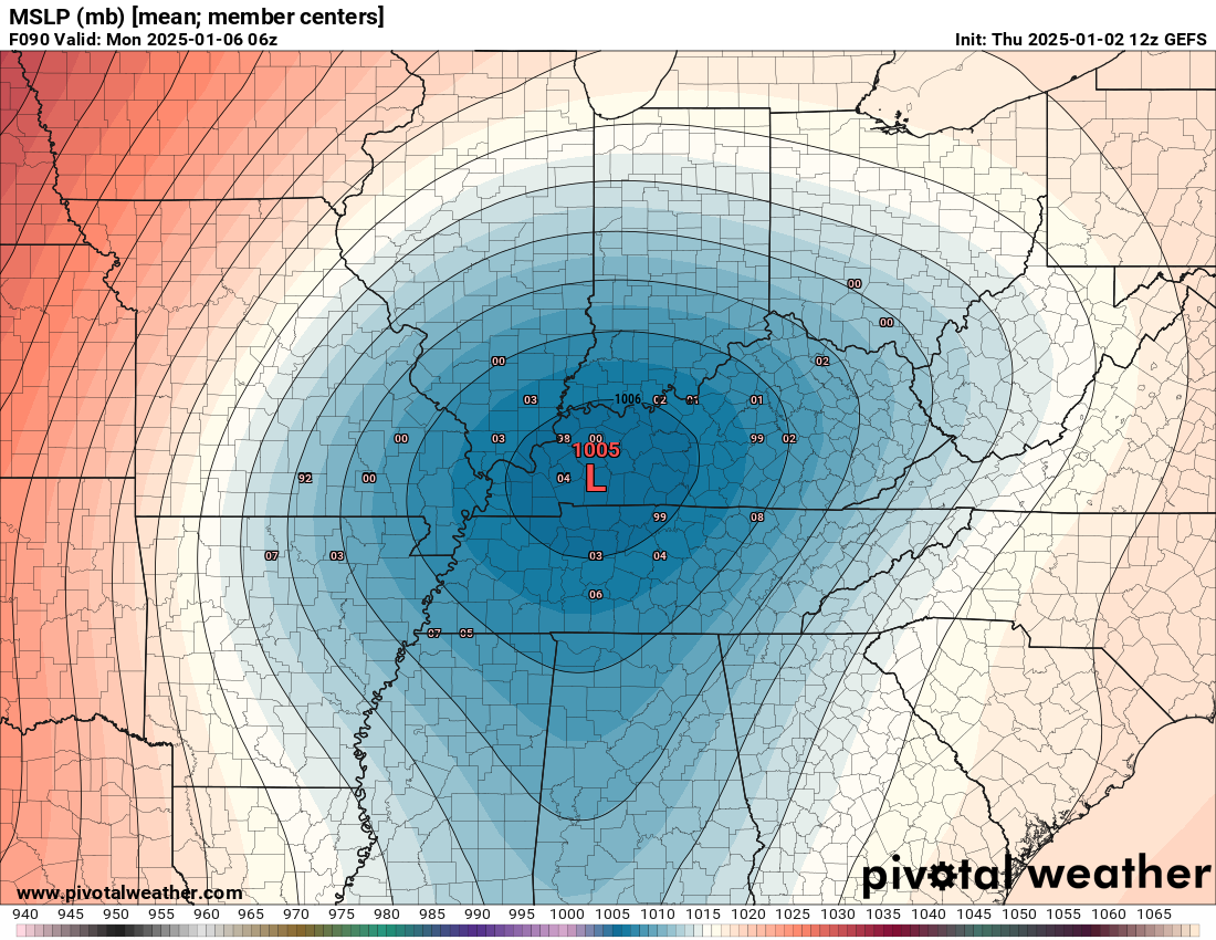
Almost every model takes the low pressure center over Kentucky. That would mean the freezing line would move fairly far northward.
Again, if the low tracks farther north we have less wintry precipitation If the low tracks farther south, then we are colder.
You can see the low on the ensembles.
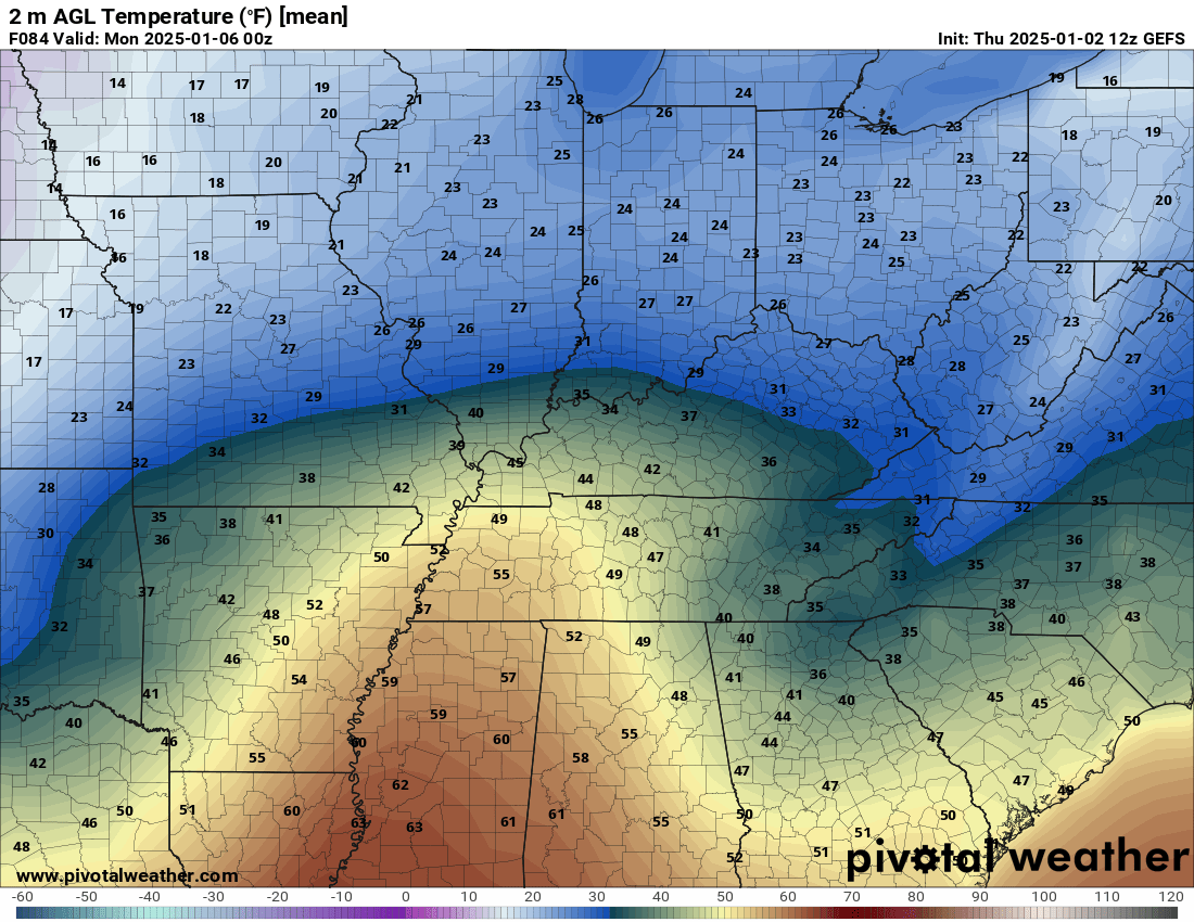
And an impressive nudge of warm air far north in our region.
This will need to be monitored. Does not mean it is right. It is just one model of many. I look for trends in the guidance.
The trend on the GEFS is warmer farther north. Also, a deeper low.
10:00 AM
Each run of the GFS model is a bit warmer farther north. Something that I am monitoring.
I always watch for trends in the model guidance. Trends usually tell you more than one model run. If a model is trending warmer with each passing run, then confidence increases that it might be on to something.
That freezing line is important in this storm.
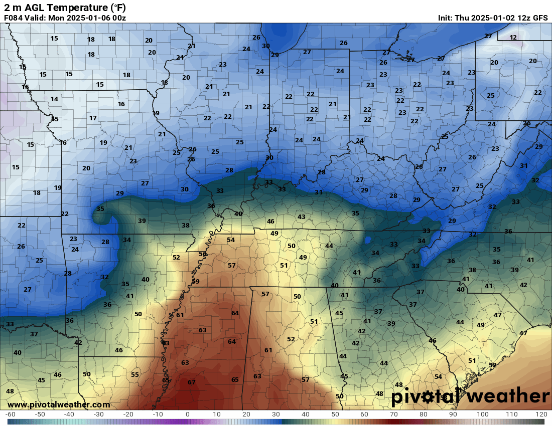
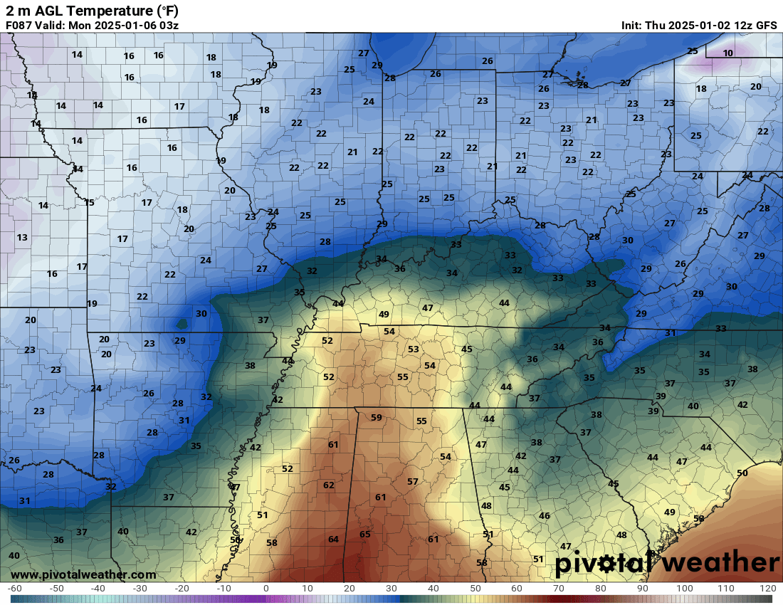
For example, here are the temperature forecast graphics from that model.
Notice how far north the freezing line advances.
6 PM Sunday
Double click images to enlarge them.
9 PM Sunday
The area of low pressure passes over Paducah on this model. Just one model of many.
9:45 AM
I am waiting on the latest GFS model data.
Almost every model is in agreement on the general track of the area of low pressure. But, any shift north or south will change the forecast for each county.
The difference between an ice storm and all rain will be a thin line. A few miles north or south. If the temperatures is a couple of degrees colder then you will have more sleet and snow vs freezing rain. Freezing rain is what causes an ice storm. That is what sticks to power lines.
Strong warm nudge with this system aloft. I believe that will lead to more sleet and freezing rain vs snow.
And, our southern counties should change to plain old rain. Just where to draw that line remains the question of the day.
.
8:44 AM
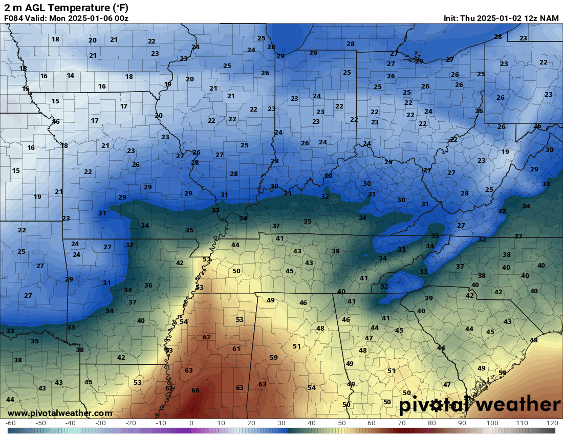
The NAM model is in. It looks very much like my graphic below.
The low passes right over our region.
Double click on images to enlarge them.
Look at the warm nudge all the way into far southern Illinois. Temperatures south of the Bootheel in the 50s and even 60s!
Any change in track will cause changes to the forecast.
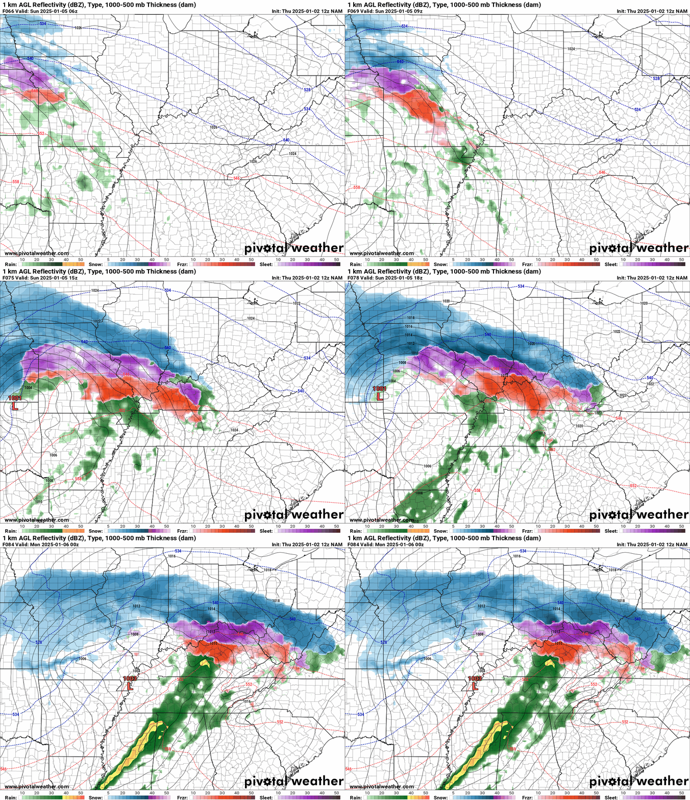
Here is the NAM model. Blue is snow. Purple is sleet. Red is freezing rain. Green is rain. Yellow is moderate rain.
The NAM model (a higher resolution model) brings snow and a wintry mix into the region late Saturday night into Sunday morning. Time stamp upper left (in Zulu time). 12z=6 am. 18z=12 pm. 00z=6 pm.
8:36 AM Update
I posted this graphic yesterday. This is my first educated guess. And that is all it is. An educated guess. Until this system moves ashore, confidence in the forecast will remain low to medium. For now, I will stick with this forecast.
Although the green zone may be mostly rain, that does not mean there won’t be impacts before the freezing rain, sleet, and snow changes to rain. Keep that in mind.
Of course, there will likely be shifts in this map. Thus, monitor updates.
Double click on images and animations to enlarge them.
8:00 AM Update
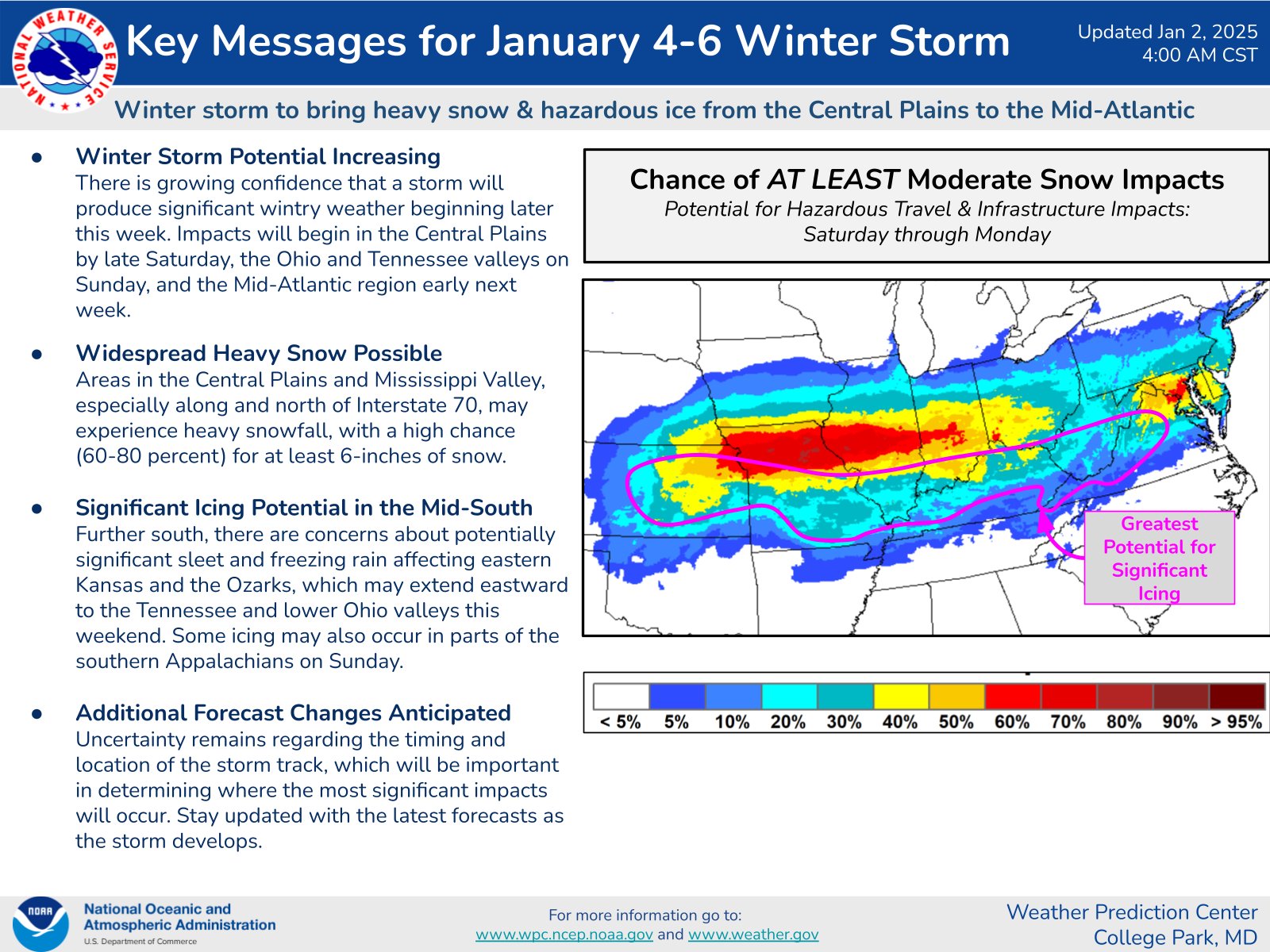
The WPC/NOAA put out this graphic. As you can see, we are in the middle of this mess. All forms of precipitation are expected.
Double click images to enlarge them.
.
7:30 AM Update
I have an ongoing Q&A thread over on Facebook. See the top thread. link click here
I will host a Q&A thread over on the Facebook page tomorrow evening at 6 pm.
.
6:30 AM update
Bottom line:
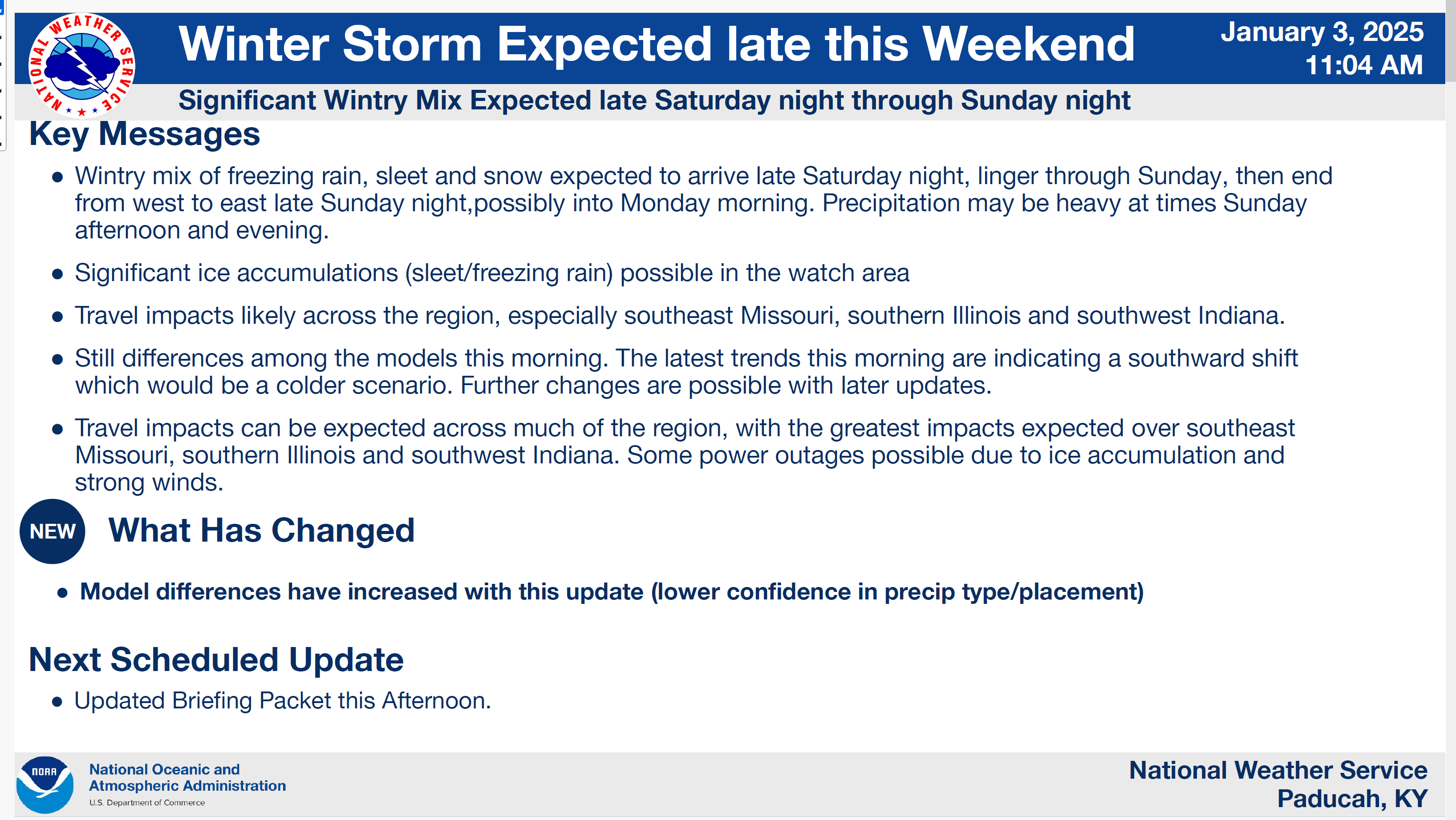
Good morning, everyone. I am tracking a major winter storm. I am also tracking bitterly cold air as we move into next week.
Monitor updates frequently if you have concerns about this winter storm.
This winter storm is still four days out. An accurate winter weather forecast is typically made 24 to 72 hours before an event. I will know a lot more tomorrow and Saturday, of course. Check back frequently for updates. Changeable forecasts are possible.
A major winter storm will impact the region beginning Saturday night and lasting into Monday. The region will experience all types of precipitation. That includes thunderstorms, freezing rain, sleet, and snow.
There could be lightning in the winter storm portion of this system, as well. That means lightning with freezing rain, sleet, and snow.Some areas will have major impacts. Some areas will remain mostly rain with little impacts. Remember, I forecast from Mount Vernon, Illinois to northwest Tennessee. A wide area from north to south.
Now is the time to make plans. Power outages are likely in the ice storm zone. At this time, we do not know which counties will experience the heaviest freezing rain. We are confident, however, that someone will experience enough ice to bring down a few power lines and tree branches.
Gusty winds of 20 to 30 mph could be an issue for power outages in the ice storm zone.
This is not like 2009 where one to two inches of freezing rain fell. With that said, there could still be a damaging ice storm in the region. Usually, damage to power lines and branches begin around 0.25″ to 0.50″ of freezing rain.
Travel Plans:
.
Don’t forget, JP has a travel app that covers much of the region.
Stay Ahead of Winter Weather with JPSTraffic – click here!
When winter weather strikes or traffic incidents happen, don’t get caught off guard.
Stay informed with real-time updates and the latest road conditions. Keep ahead of the storm—sign up today at jpstraffic.com – click hee.
Beau’s Weather Analysis
It is important to remember that a an accurate winter storm forecast is typically made 72 hours before an event. We then refine it as the storm draws closer to the region. This is why the National Weather Service waits on issuing watches, warnings, and advisories. We need higher confidence on the storm track before we issue those products.
72 hours – our first forecast is made concerning amounts.
48 hours – we refine the forecast and make adjustments.
24 hours – an accurate freezing rain, sleet, and snow forecast is expected. Adjustments are still possible.
Even while a winter storm is underway, there can be surprises. Someone always receives more and less than anticipated. That is just the nature of winter storms.
We are still four days out from this event.
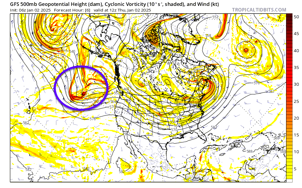
The system is still out over the Pacific Ocean. It won’t come ashore until Friday/Friday night. Once the system moves ashore, the models can sample it better. That equals a more accurate forecast.
Here is the winter storm. The purple circle. Models don’t sample as well when storms are over the ocean. Limited data is available.
At this time, I am forecasting freezing rain, sleet, and snow to move into southeast Missouri Saturday night. It may reach into southern Illinois , western Kentucky, and northwest Tennessee before sunrise, as well. The timing is one portion of the forecast that I am still monitoring (fine tuning).
Precipitation will overspread the region during the day on Sunday. A wide range of temperatures will create a wide range of precipitation types.
Sunday morning churches may be impacted by travel conditions. Cancellations are certainly possible.
I expect this to be mostly a rain event from the Missouri Bootheel into northwest Tennessee and then into portions of western Kentucky.
Where exactly to draw the ice vs rain line is tricky this far out. There will, of course, be a cutoff zone. Where the rain changes to freezing rain, sleet, and snow. That line may fluctuate a bit. Depending on storm track.
I would not be surprised if the event started out frozen area-wide. Then, as the warm front moves northward and temperatures rise, the precipitation will change to plain old rain from south to north.
There will be a line somewhere in the region that remains all snow and ice. That includes enough freezing rain for ice storm warnings. There is the potential for 0.30″ or greater of freezing rain. Where this occurs, power line and tree branch damage will likely occur.
It is too early to know where that will be.
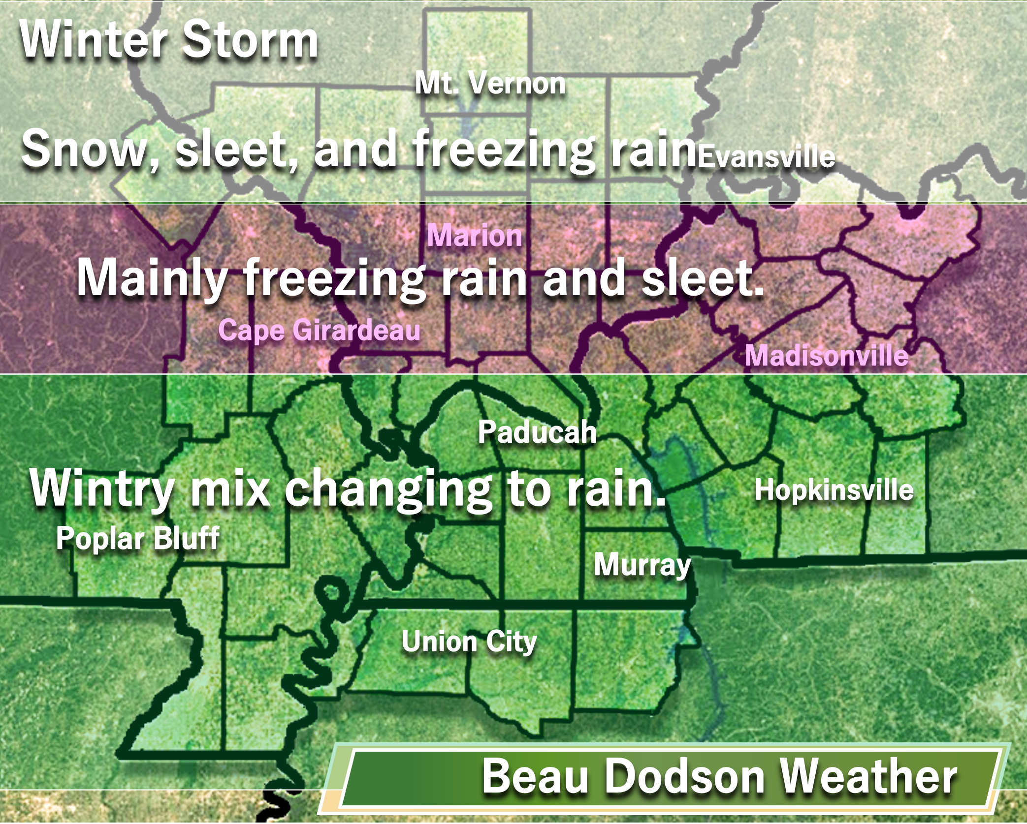
I posted this graphic yesterday. This is my first educated guess. And that is all it is. An educated guess. Until this system moves ashore, confidence in the forecast will remain low to medium. For now, I will stick with this forecast.
Although the green zone may be mostly rain, that does not mean there won’t be impacts before the freezing rain, sleet, and snow changes to rain. Keep that in mind.
Of course, there will likely be shifts in this map. Thus, monitor updates.
Double click on images and animations to enlarge them.
.
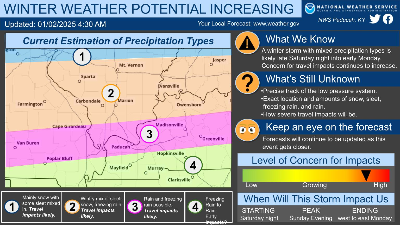
The Paducah, Kentucky, National Weather Service posted this graphic early Thursday morning
Our ideas are similar.
The track of the area of low pressure is key to who receives freezing rain, sleet, snow, and rain (even some rumbles of thunder).
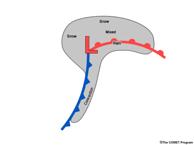
This is what a classic winter storm looks like. The red L is the area of low pressure. Cold to the north. Warmer south of the warm front (the red line). The blue line is the cold front.
.
MODELS
Let me show you some model guidance.
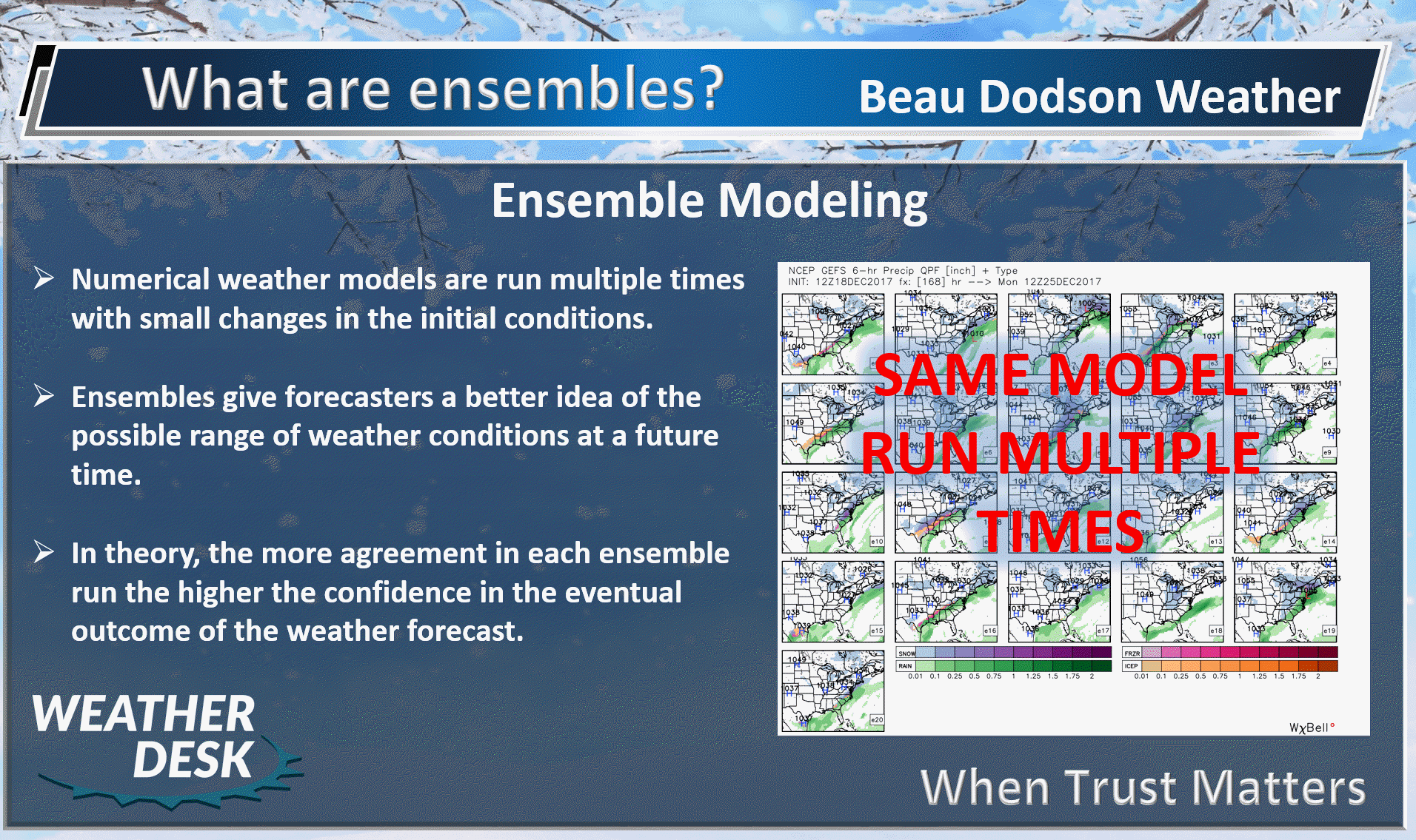
These are model ensemble graphics.
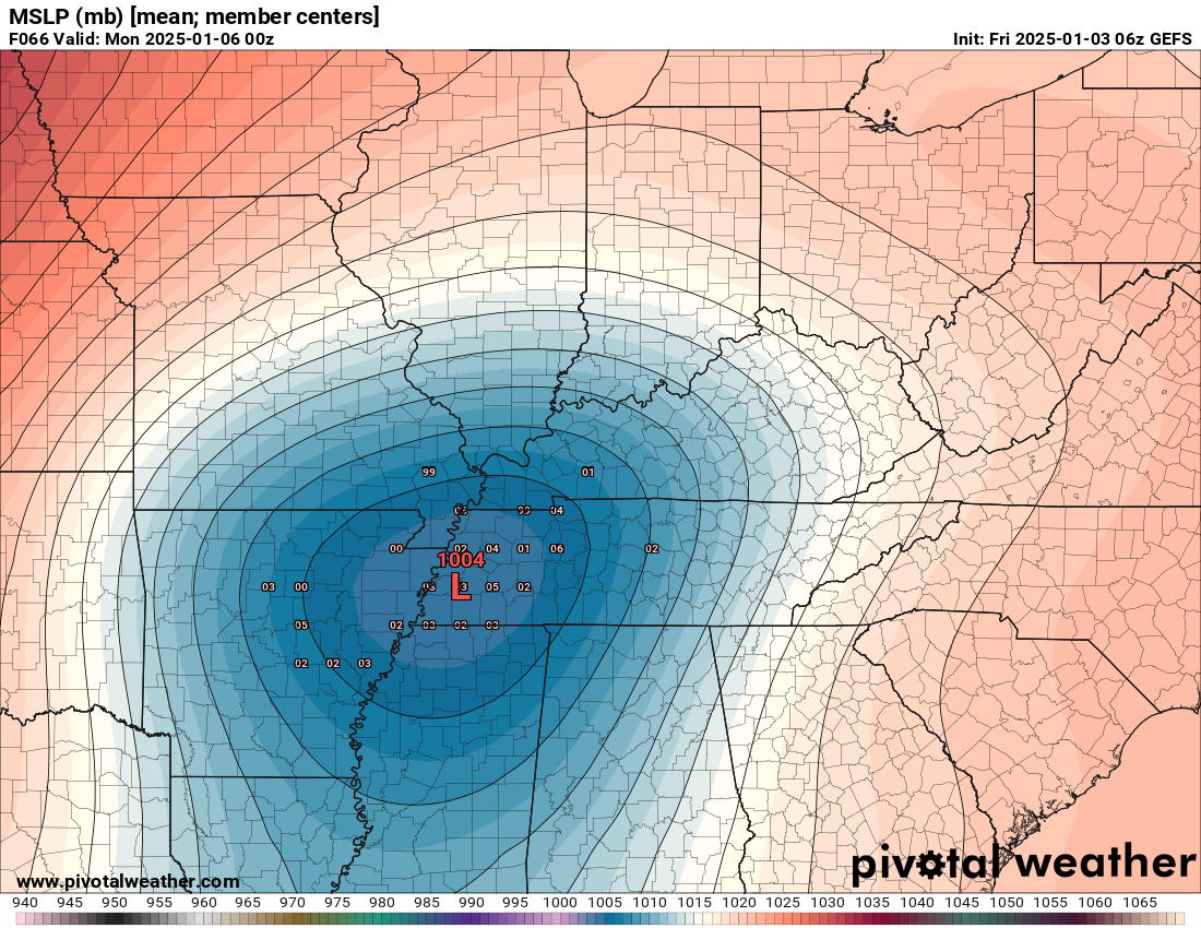
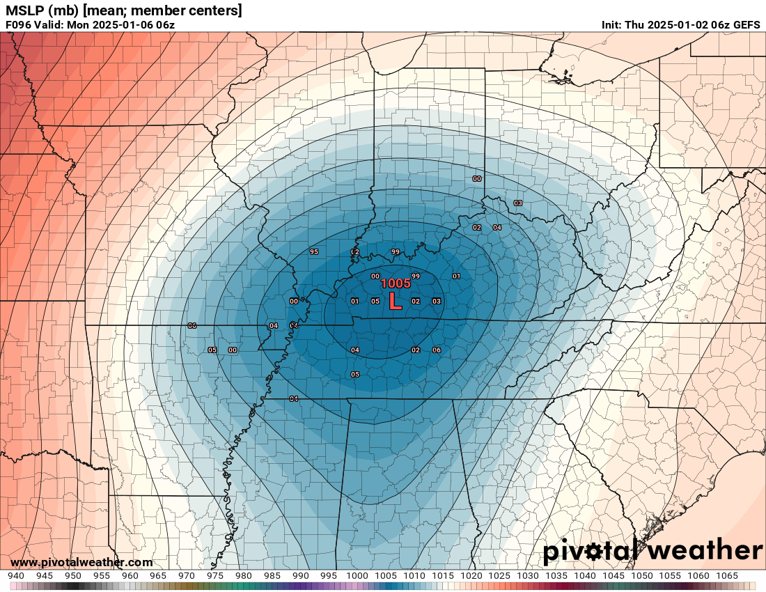
The GEFS model tracks the low right over our region. The red L is the area of low pressure.
This shows the mean of all the ensembles. All the other little numbers are where it could track, as well. There is a tight clustering which adds some confidence to the forecast.
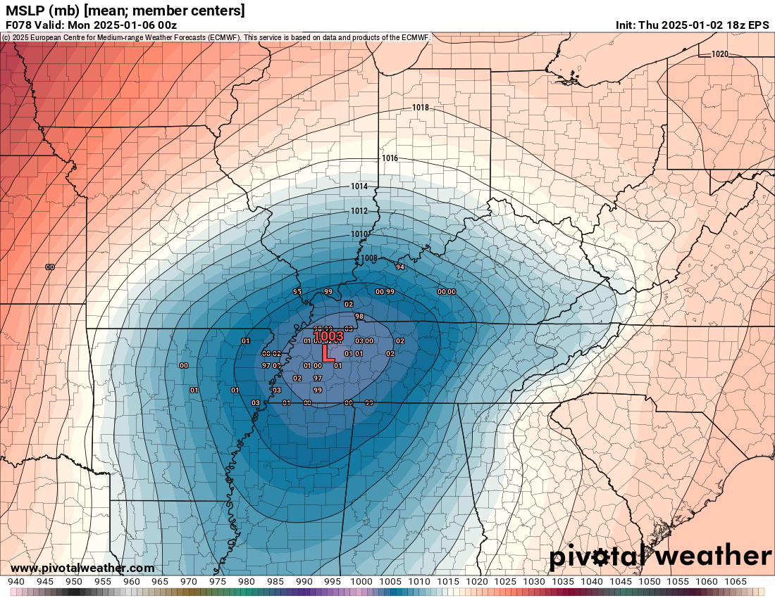
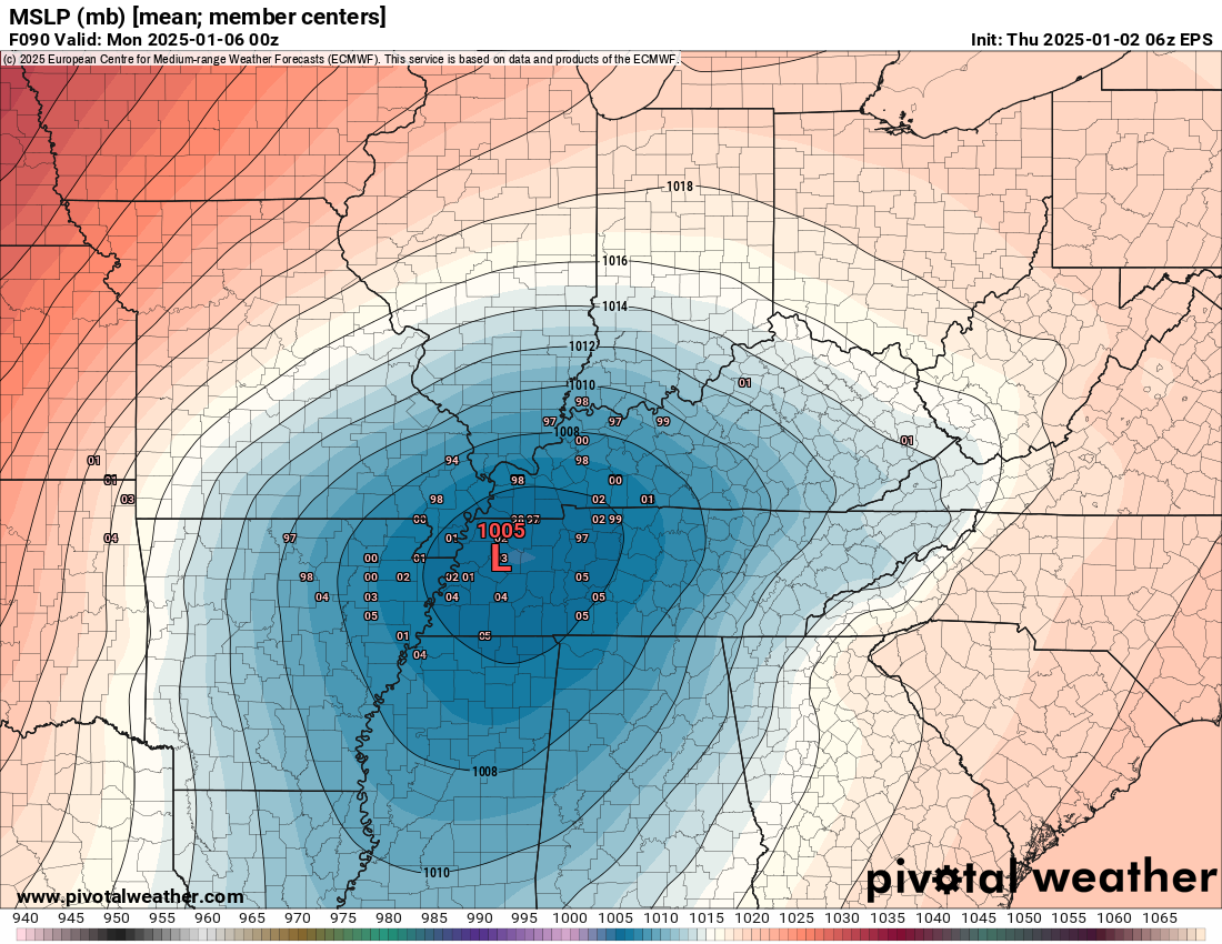
The EC model tracks the low right over our region, as well. Perhaps a bit farther south (by a few counties).
The big red L is the mean. All the other numbers are possible tracks.
Again, these is tight clustering around the path track.
.
Any shift in this track will change the going forecast. Even a fifty mile shift would make a difference to the final forecast.
Let me show you how difficult this forecast is.
I am expecting everything from thunderstorms south to snow north. I would not be surprised to see lightning in the snow and ice sector, as well.
Here are three models.
Notice how similar they are, but also notice that any slight change in storm track will change your local weather forecast. We are threading a needle this far out (four days out).
If the low shifts 50 miles north or south, then your forecast will need adjusting. Tricky forecast, to say the least.
Just about everywhere in the region begins as a wintry mix on these models. Then, some change to all rain.
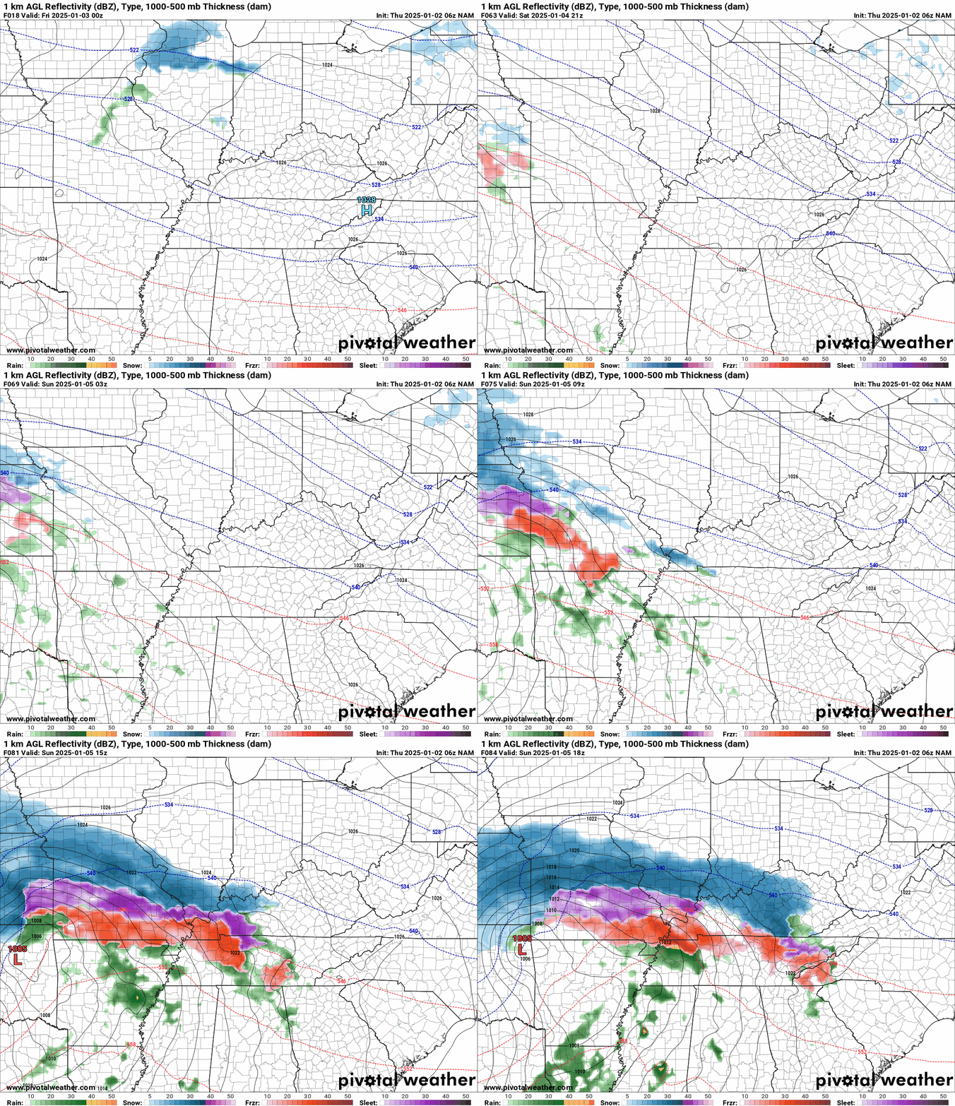
Here is the NAM model. Blue is snow. Purple is sleet. Red is freezing rain. Green is rain. Yellow is moderate rain.
The NAM model (a higher resolution model) brings snow and a wintry mix into the region late Saturday night into Sunday morning. Time stamp upper left (in Zulu time). 12z=6 am. 18z=12 pm. 00z=6 pm.
This particular model only goes out to Sunday noon. Precipitation will continue into Monday. Double click on images and animations to enlarge them.
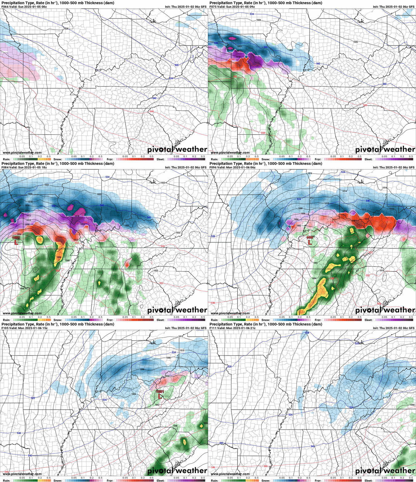
Here is the GFS model
The GFS keeps our far southern counties in rain the entire period. With little or no snow or ice impacts. It even has some thunderstorms.
Here is the EC model
The EC model looks very similar to the GFS model. Notice how it keeps our southern counties mostly rain.
.
Amounts
Temperatures aloft will determine precipitation type. A warm wedge aloft is why this won’t be a pure snow event for most areas.
If portions of the region remain all snow, then they will receive four or more inches. Areas that mix with freezing rain and sleet will receive less than four inches of snow.
Sleet accumulation of 1/2″ or more is possible.
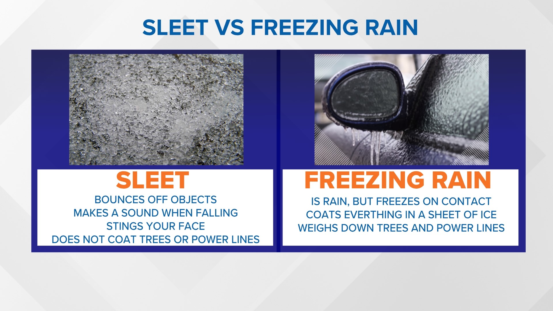
Remember, sleet is a little pellet of ice. Sleet bounces. Sleet does not stick to power lines or branches.
Freezing rain is what causes power lines and branches to fall.
Freezing rain accumulation of 0.01 to 0.30″ will be possible. Perhaps locally higher than 0.30″. This could cause some damage to power lines and tree branches.
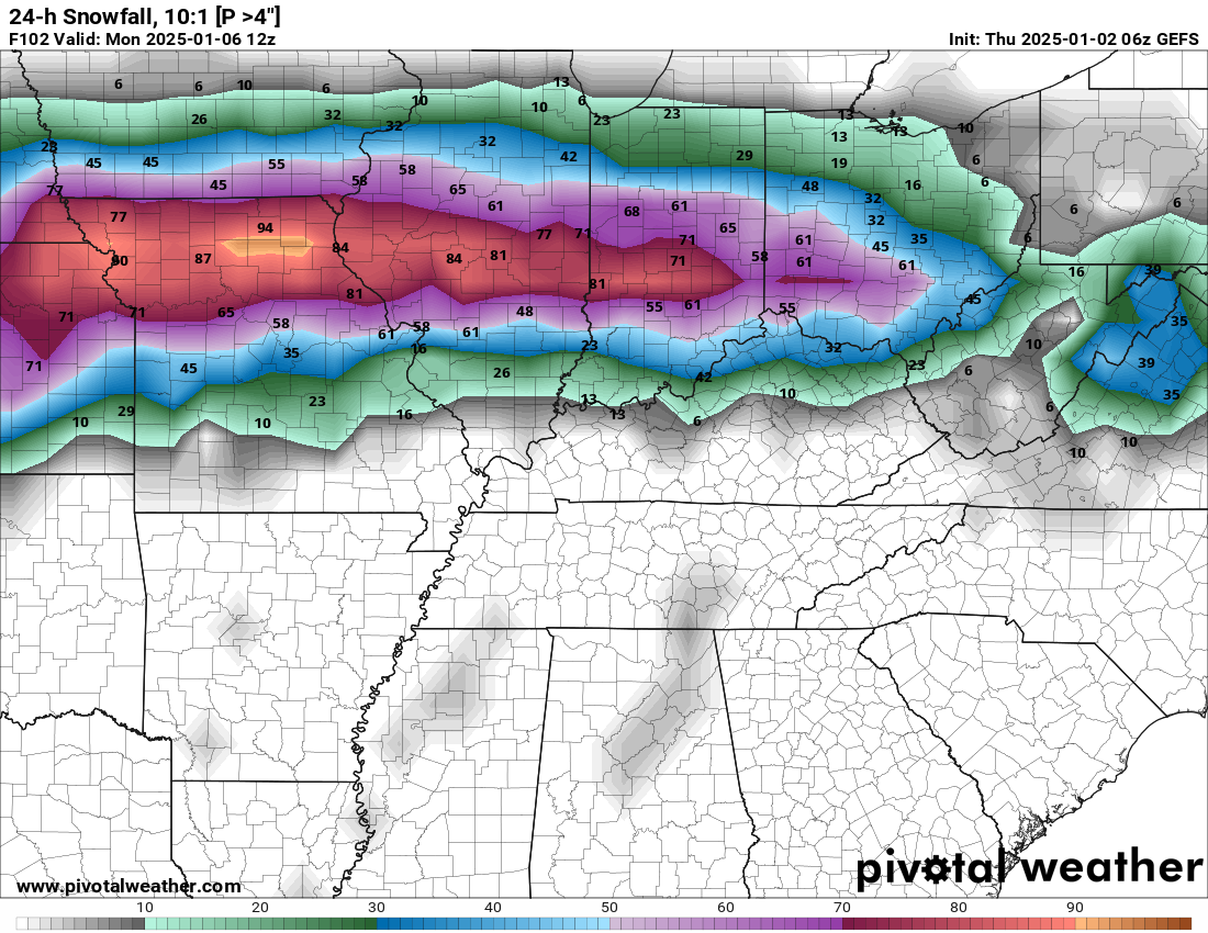
Let me show you some ensemble data concerning totals.
.
WHAT WILL I BE WATCHING TODAY?
I will be watching trends. That means that I will be watching to see if this shifts north or south with each model run. Trends typically tell us more about a system than just one model run. If a system is trending north or south in the data, then you can assume it might continue to do that. That helps me make a more accurate forecast.
We don’t make a forecast based on one model run. We have to figure out what the final outcome will look like. Trends are more important than just one model run.
Let me show you some more data.
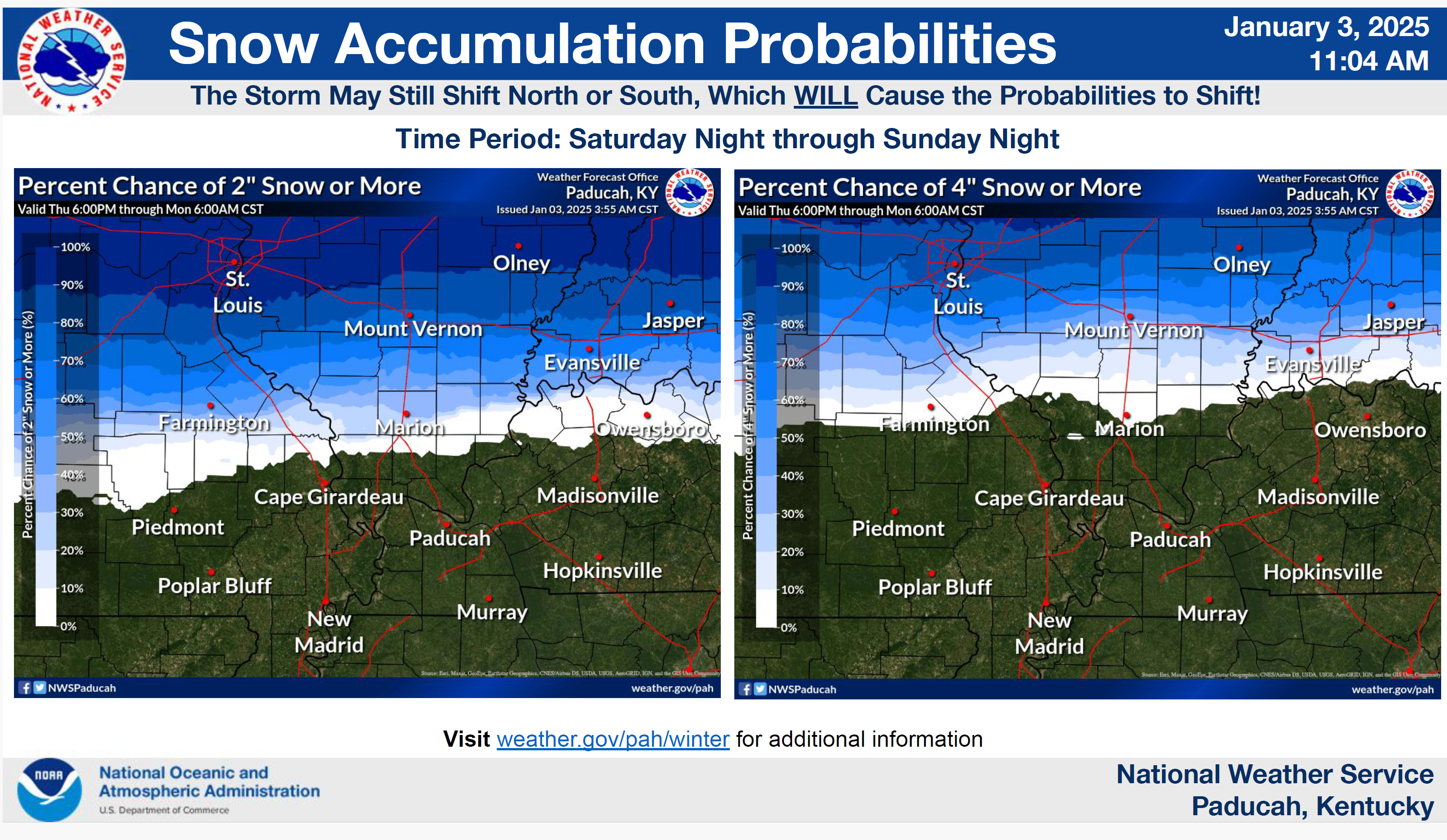
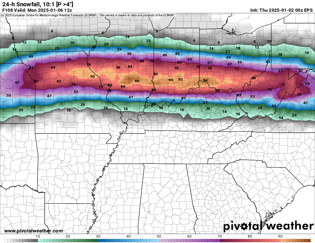
What is the probability of four or more inches of snow?
GEFS model
Double click on images and animations to enlarge them.
EC model
The EC model is slightly farther south with the snow. A few counties.
What is the probability of four or more inches of snow?
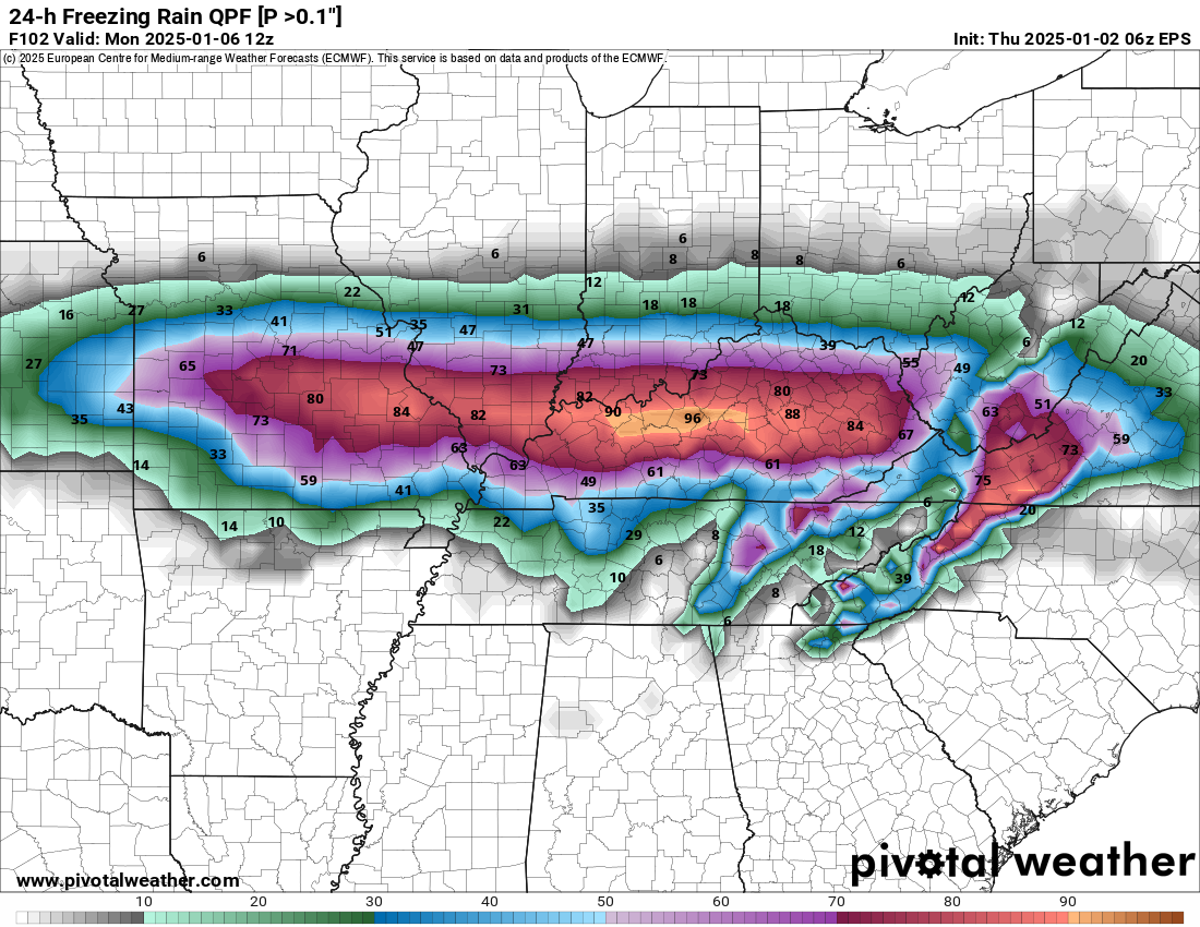
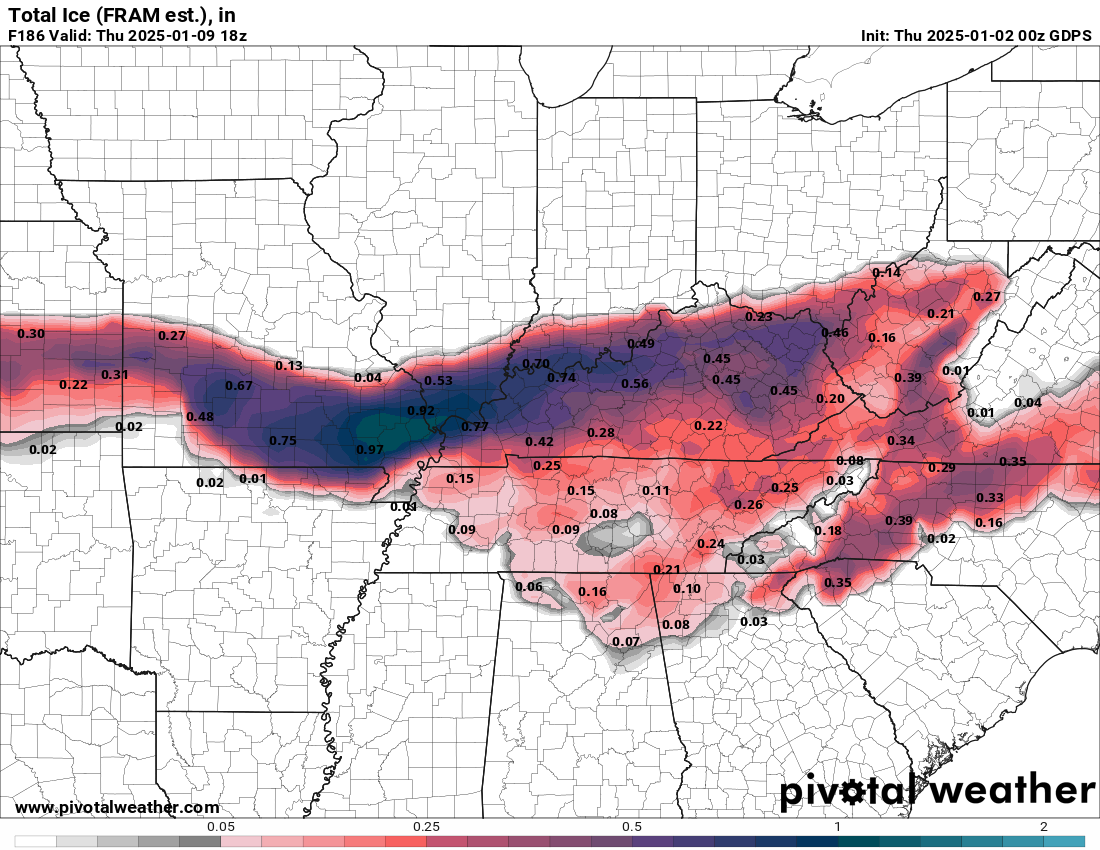
Let’s look at the EC models freezing rain forecast. Where is 0.10″ or higher of freezing rain totals anticipated.
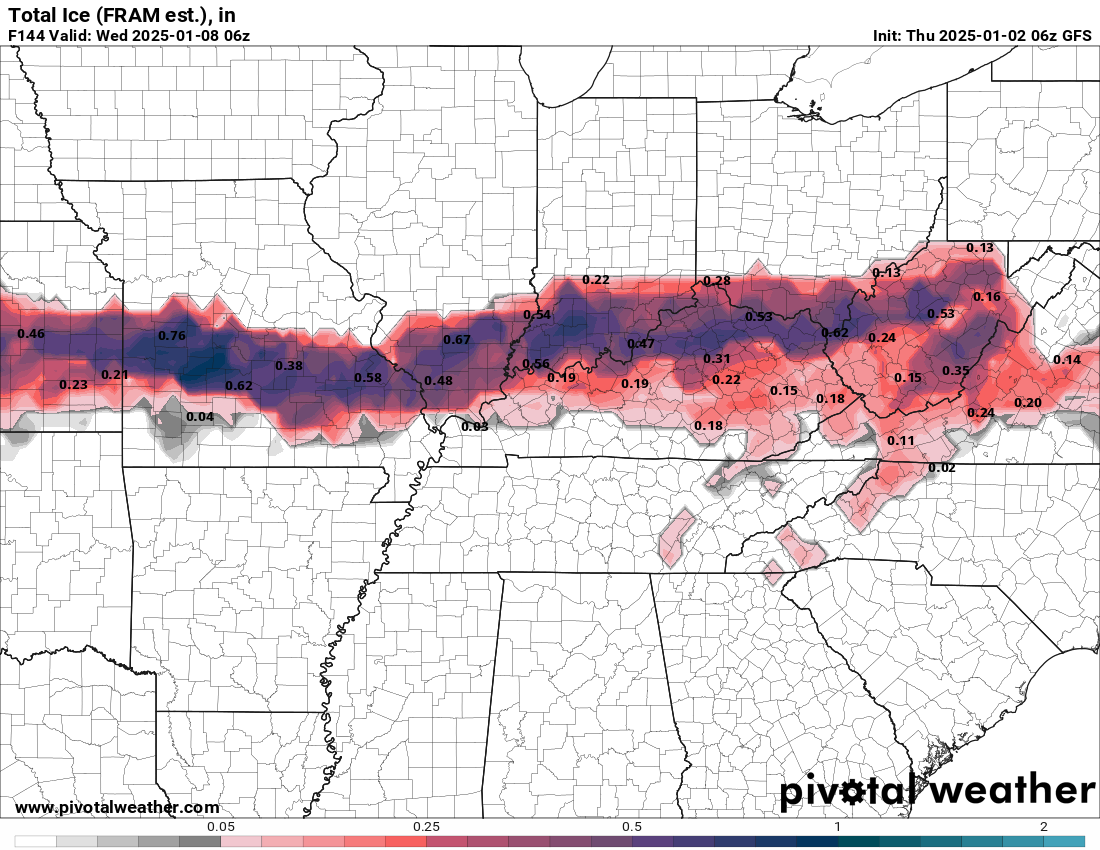
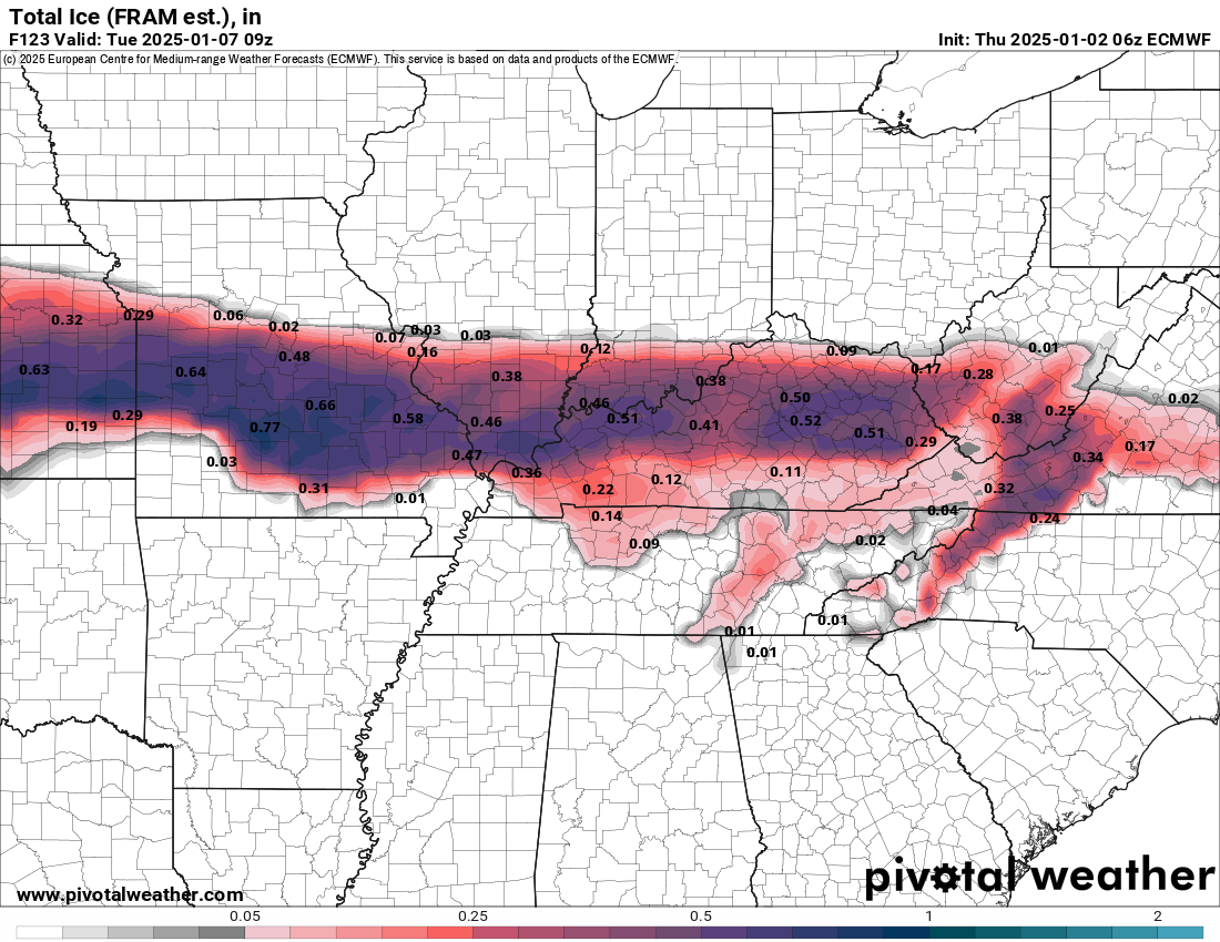
Let me show you three models.
This is freezing rain accumulation. Notice that they are similar.
Areas south of the freezing rain may experience a brief period of icy travel conditions, but then change to all rain.
Notice how similar they look. There are small differences. A few counties north or south.
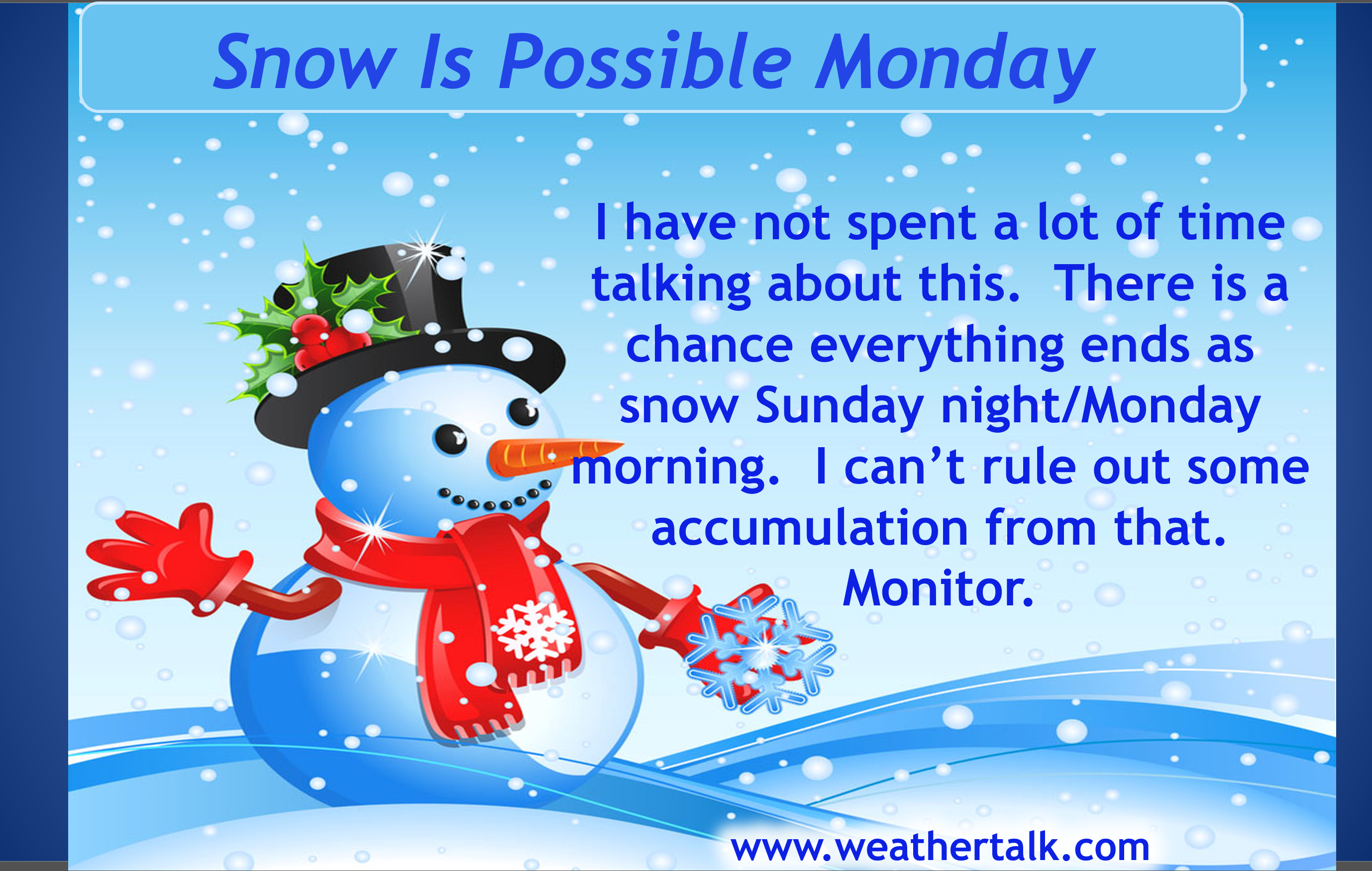
The system will pull away from the region Monday. On the back side of the system there will likely be snow showers. I can’t rule out some snow accumulation as the system pulls away.
Temperatures over the next two weeks will vary wildly. Areas with snow and ice on the ground will be 10 to 20 degrees colder than areas without.
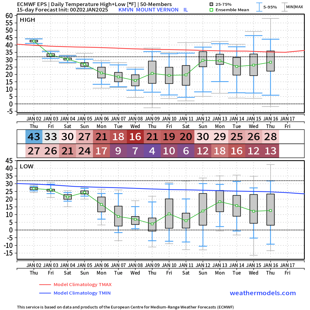
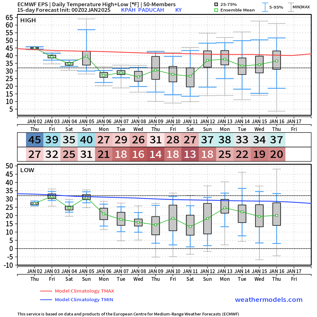
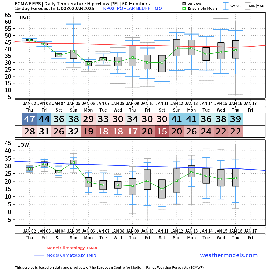
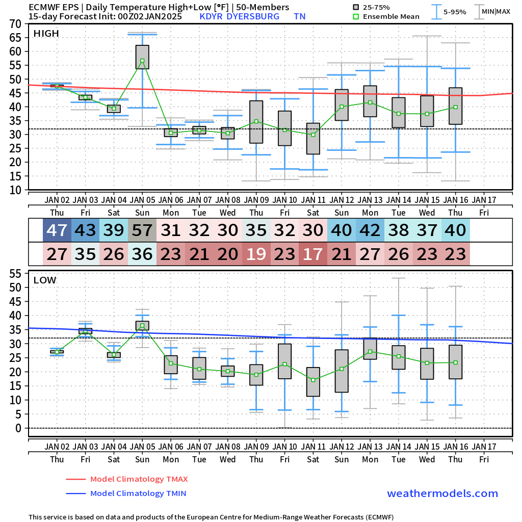
Let me show you some temperature forecast numbers. I chose four locations in our region.
You can see the date and the average high and low that is being forecast. In the middle of the graphic is the average.
These go out to the middle of January.
Notice the differences. Snow and ice will make a big difference with high and low temperatures. Wind chill temperatures will be even colder.
Mount Vernon, Illinois
The top number (43) is the expected Thursday high. The bottom number (27) is the expected Friday morning low.
.
Paducah, Kentucky
.
Poplar Bluff, Missouri
.
Dyersburg, Tennessee
.
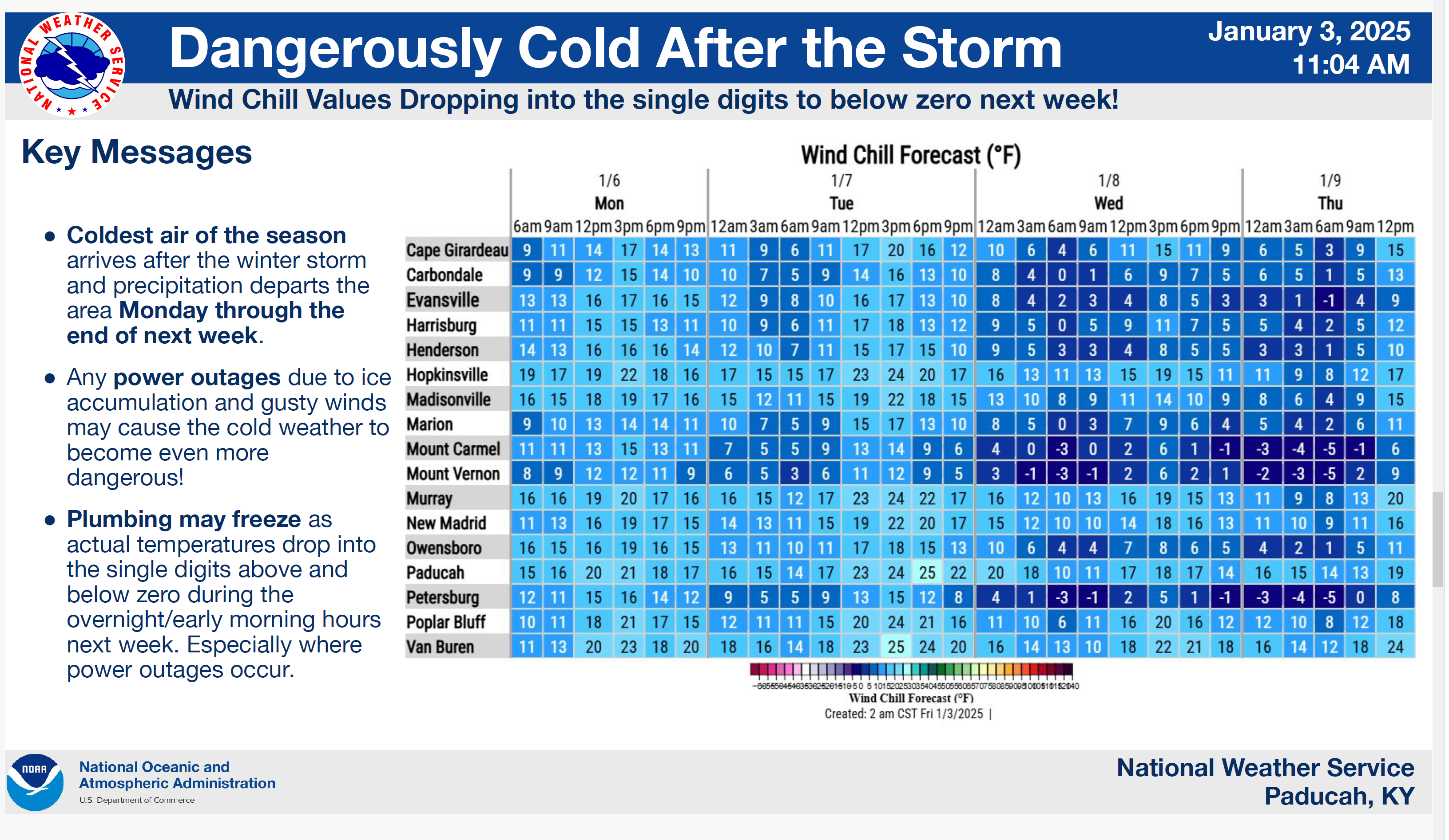
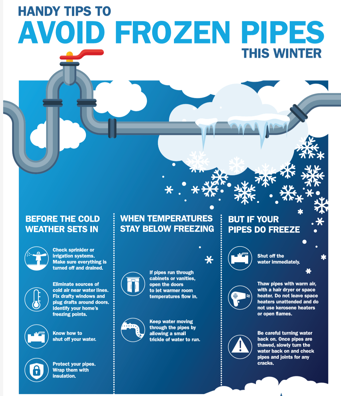
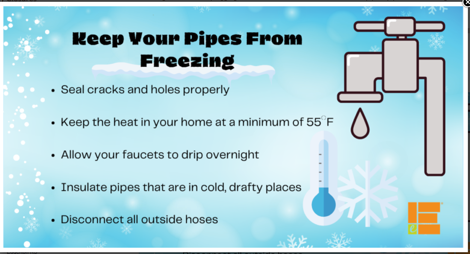
Plan on periods of bitterly cold air. Cold enough in some counties to damage pipes. If a heavy snowpack develops, then some areas will drop into the single digits for lows.
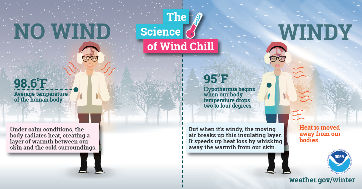
Wind chill values will be cold tonight and tomorrow morning. Wind chill values will be an issue during the winter storm into all of next week, as well.


