Not a subscriber? Go to www.weathertalk.com/welcome
Subscribe to Weather Talk. Then go to the app store and download it. Search for Weather Talk or Beau Dodson Weather. Apple users click here. Android users click here
.
What you need to know.
Key Points
- A few of the thunderstorms on Tuesday could produce hail and high wind. Perhaps a tornado.
- Some hail is possible during the morning. The greater concern is from the afternoon into the evening hours. The risk is highest over Tennessee and decreases as you move further north.
- Have three or more ways of receiving your severe weather information. That includes my Beau Dodson Weather Talk app and a NOAA Weather Radio.
.
Call to action.
Monitor updated weather forecasts.
Remember, a watch means that conditions are favorable for severe thunderstorms to form.
A warning means to take action. Seek shelter. A warning is more serious than a watch.
Make sure you are using the Weather Talk app. Download it from the app store. It is under Weather Talk.
TURN IT ON. Make sure it is on. Make sure you have not accidentally logged out of the app.
The app is for subscribers (please log into your account and make sure your payment has been updated. We have a large number of declined cards and PayPal payments). Subscribe at www.weathertalk.com/welcome then go to your app store and search for WeatherTalk. Apple users click here. Android users click here
.
Tuesday, March 24, 2020
7:45 AM Update
Storm tracking tools
Radars
Interactive city-view radars
http://weatherobservatory.com/weather-radar.htm
A third backup radar
https://weathertalk.com/morani
Clickable watches and warnings can be viewed on the local city view interactive radars (link above). Be sure and turn on the warnings above the local radars.
A new regional radar we offer
https://imagery.weathertalk.com/prx/RadarLoop.mp4
Lightning data
https://wtalk.co/7QT7WHKU
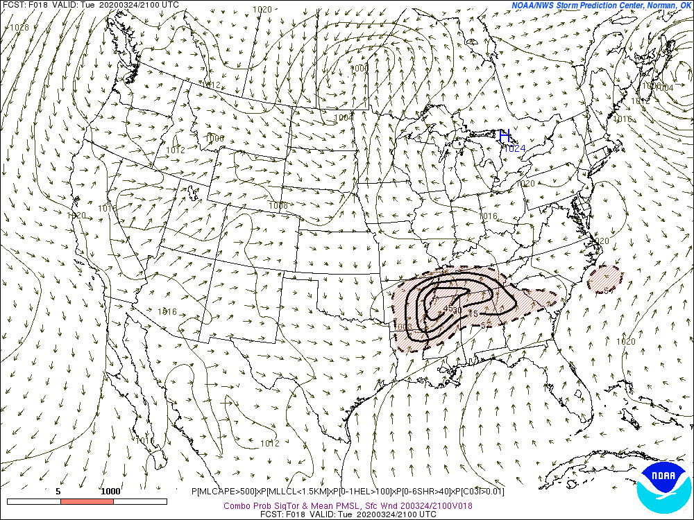
The greatest concern, over the next 12 to 16 hours, will be across western Tennessee. Concerns decrease as you move further north.
You can see that on this SPC severe weather outlook graphic. The yellow zone is the greatest risk. The dark green is a level one risk (one is the lowest). The light green is where lightning may occur, but not severe weather.

Widespread showers and thunderstorms this morning. The rain will move southwest to northeast. Locally heavy rain and lightning is the primary morning concerns. Perhaps a few reports of dime to nickel size hail.
That rain is occurring along a warm front. The warm front will continue to slowly move northward through the morning hours.
The warm front will not advance across the entire area.
I can show you the track of that warm front on these three surface map images.
The warm front is the red line with half oval shapes. You can see that it does push into western Tennessee and perhaps clips western Kentucky this afternoon.
Typically, the greatest severe weather risk occurs along and south of the warm front. We call that the warm sector. The air is more unstable in those areas.
Thus, today’s severe weather concerns will mainly be across the Missouri Bootheel and then along and south of the Kentucky/Tennessee State line.
If thunderstorms form north of the warm front then a few reports of hail would be possible. Monitor the app.
Early morning
Mid-day
Early evening
.
You can see the tornado ingredients have shifted southward.
Today’s map.
And this was the map from Monday

.
Monday, March 23, 2020
No changes in the evening data.
The main concern will be some hail during the AM hours. This will occur as a band of thunderstorms moves out of Arkansas and pushes northeast across the region.
Then, another round of storms during the afternoon and evening.
The greatest risk of severe weather will be across the Missouri Bootheel, western Kentucky, and western Tennessee. The risk lessens as you move northward.
Monday, March 23, 2020
Severe thunderstorms are possible on Tuesday/Tuesday evening.
There remain some questions about the placement of the severe weather risk on Tuesday and Tuesday evening.
If the area of low pressure tracks further south then the severe weather threat will be focused across southern Kentucky and Tennessee. If the low tracks further north then the threat of severe weather pushes further north, as well.
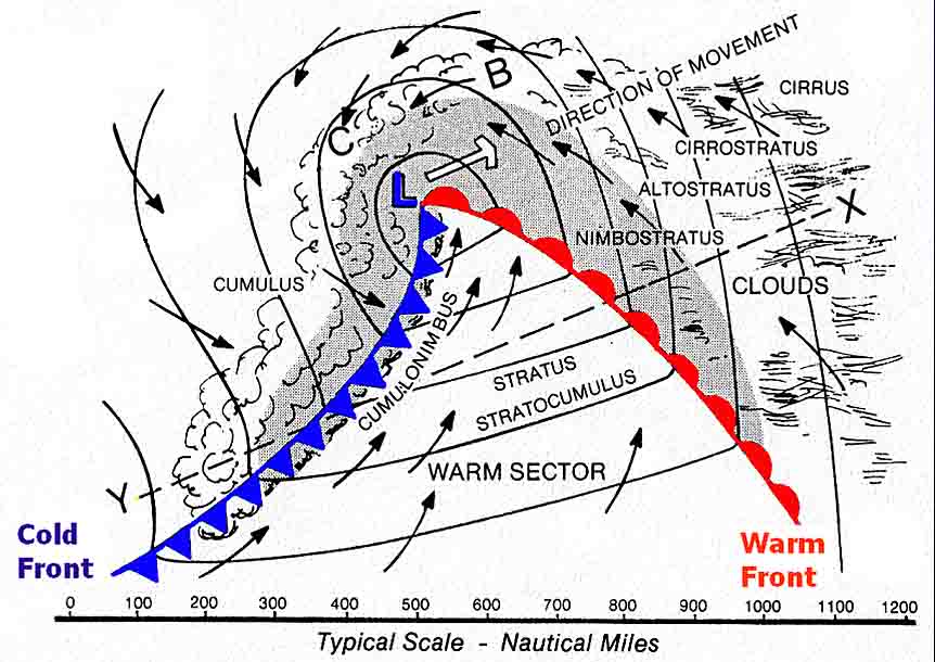
Let me show you an example. This graphic shows you the center of low pressure. That is the blue L. The red half-ovals represent the warm front. The blue line with triangles is the cold front.
The warm sector is south of the warm front. This is generally where severe weather usually occurs. You can have hail north of the warm front, as well.
.
As it stands, I have the warm front near the Kentucky/Tennessee border.
Some hail could occur just north of the warm front and then south of the warm front.
We will have to closely monitor the cold front that pushes in from the west, as well. That will occur during the late afternoon and evening hours.
Our first round of thunderstorms will accompany the warm front during the morning hours. Some of those thunderstorms could produce a few hail reports. Locally heavy rain, as well.
Then, thunderstorms will develop along an incoming cold front during the afternoon hours. Those storms will push eastward across the region.
The main concern with this event will be large hail and damaging wind. A low-end tornado risk.
.
Parameters
Let me show you some of the severe weather parameters that the NAM and GFS models are showing.
CAPE is energy for thunderstorms. Higher CAPE numbers usually mean more severe weather.
We can have low CAPE and high wind shear events. Those events feed off of strong jet stream winds. Usually, low CAPE events are doing the winter months. Sometimes early spring.
Our last event was a low CAPE/high wind shear event.
The GFS model shows CAPE spreading into the region Tuesday morning and afternoon. There is a sharp cut-off. That is the warm front. Normally, the warm front is where you monitor for large hail and tornadic storms. Not always, of course. This will need to be monitored.
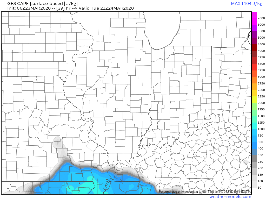
Tuesday evening CAPE. Not a lot of CAPE, but enough to warrant some concern. The best advice is to monitor updates.

.
The NAM model, however, shunts the CAPE further south. This will need to be monitored. If the southern track verifies, then the severe weather risk will shift southward, as well.

.
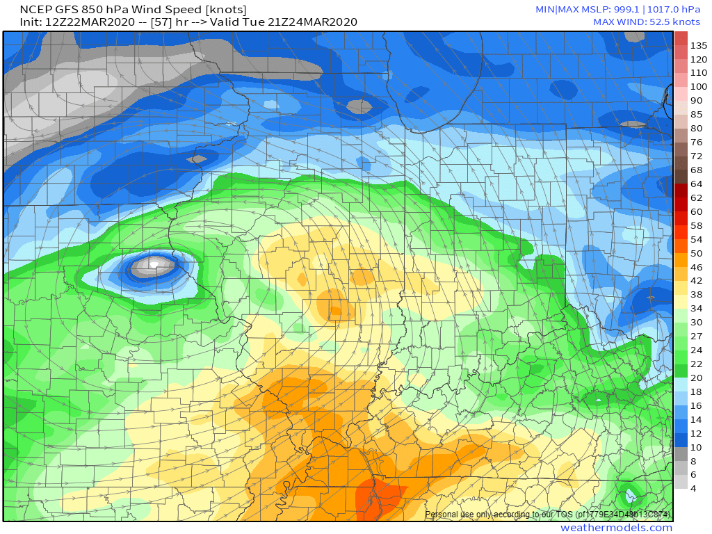
850 MB wind speeds will be zipping along above 50 knots. Strong winds help fuel thunderstorms. I always watch 850 MB winds when considering the severe weather risk.
Higher numbers equal higher severe weather concerns.
These are not extreme numbers, but they are sufficient for severe weather.
.
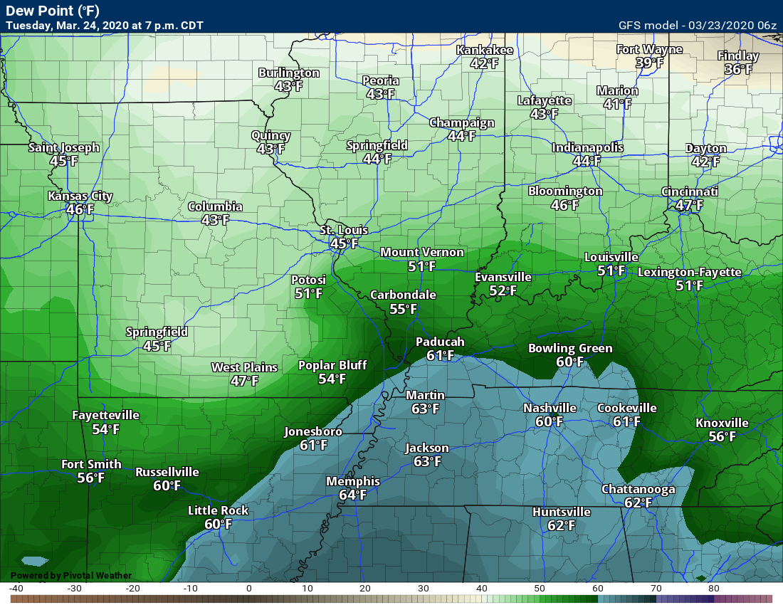
Dew points are marginal for severe weather. Typically, I look for readings at or above 60 degrees.
Remember, dew point is a measure of moisture in the atmosphere.
You can see the numbers are around 60 degrees.
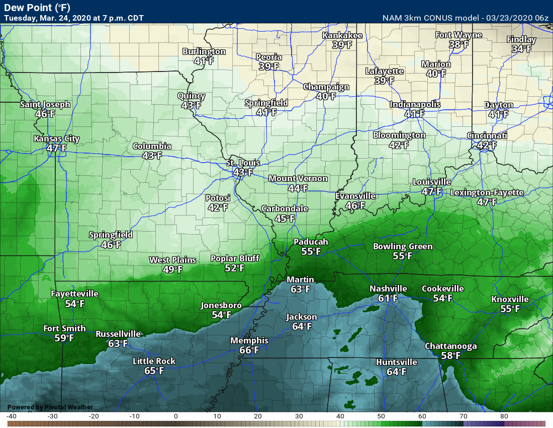
This is the GFS model. The second image is the NAM model. The NAM is further south and would keep the greatest threat over Tennessee.
The warm front will be key. If the warm front is further north, then the severe weather risk will expand northward, as well.
And the NAM model
.
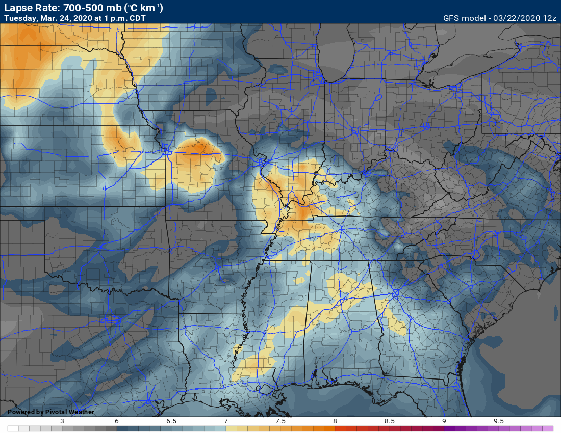
Lapse rates are decent. Lapse rates represent how fast temperatures cool aloft. The faster they cool the higher the chance of severe weather. Especially hail.
High lapse rates are an indication that you can have numerous hail reports.
.
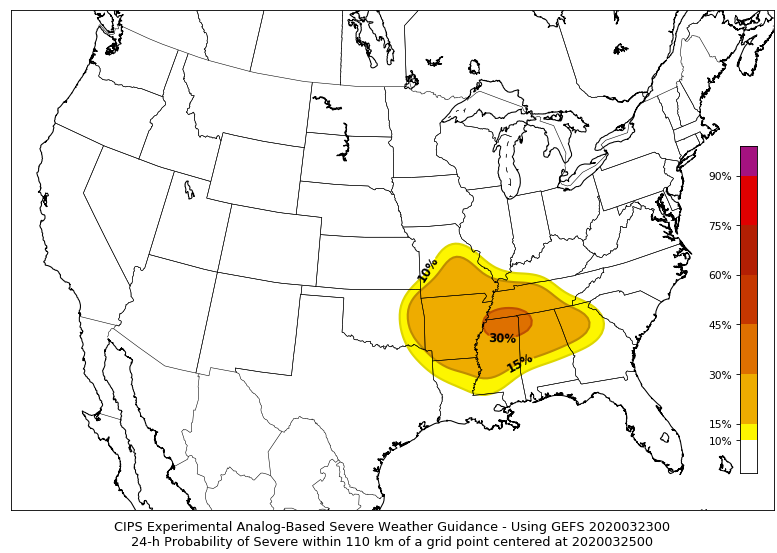
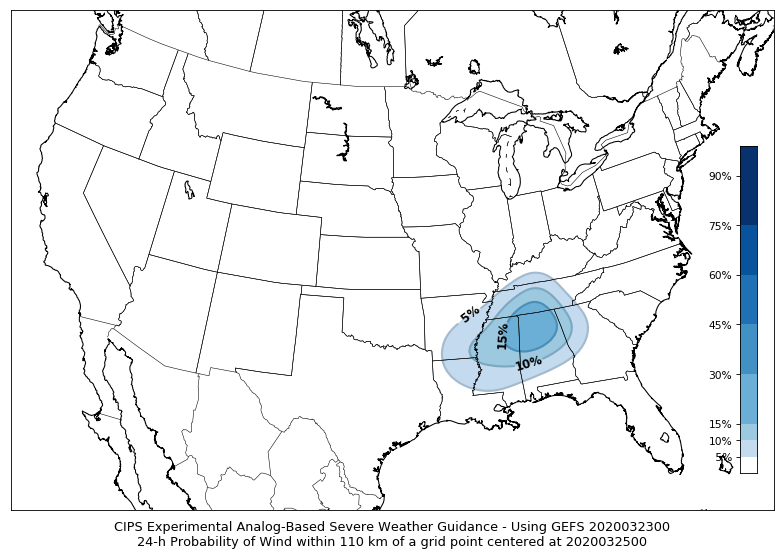
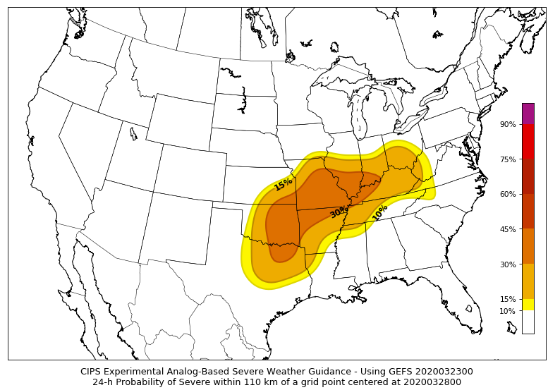
Analogs show some risk.
Analog forecasting involves looking at past events and comparing them to an upcoming event.
Here is the CIPS analog forecast. You can see it does highlight our region with the potential of severe weather.
Analog hail forecast

Damaging wind.
.
Tornado ingredients show some risk, as well.
.
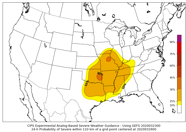
Analogs also show some risk as we move towards Friday and Saturday. Again, these are analog maps.
Friday
Saturday
Radars
Interactive city-view radars
http://weatherobservatory.com/weather-radar.htm
A third backup radar
https://weathertalk.com/morani
Clickable watches and warnings can be viewed on the local city-view interactive radars (link above). Be sure and turn on the warnings above the local radars.
A new regional radar we offer
https://imagery.weathertalk.com/prx/RadarLoop.mp4
Lightning data
https://wtalk.co/7QT7WHKU
Not receiving app/text messages?
USE THE APP. ATT and Verizon are slowing or stopping the text messages.
Make sure you have the correct app/text options turned on. Find those under the personal notification settings tab at www.weathertalk.com. Red is off. Green is on.
Subscribers, PLEASE USE THE APP. ATT and Verizon are not reliable during severe weather. They are delaying text messages.
The app is under WeatherTalk in the app store.

Apple users click here

Android users click here
.

Live lightning data: Click here.