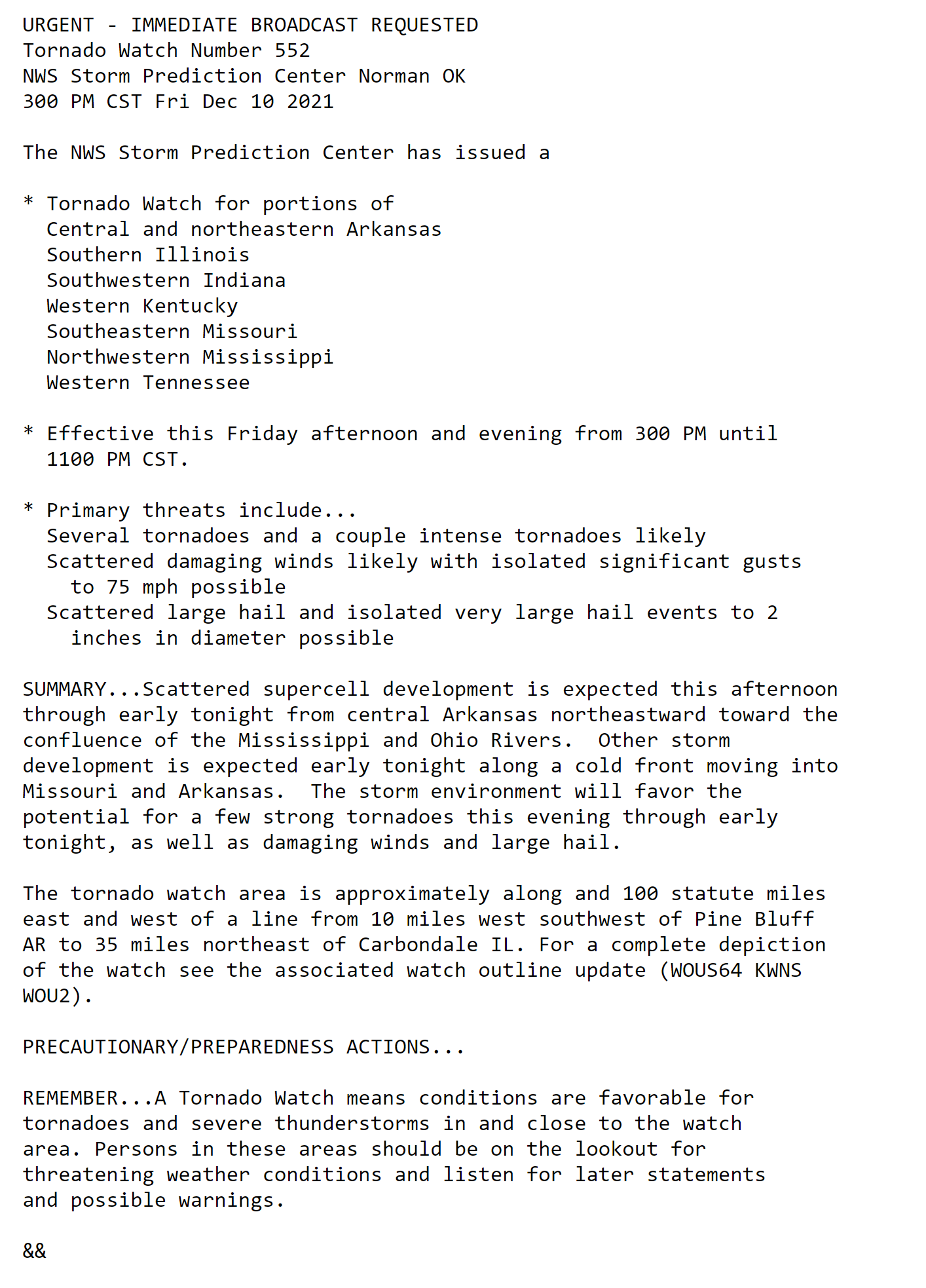
Click on the words below to subscribe
Storm Tracking Links
Interactive local city-view radars. Clickable watches and warnings.
https://wtalk.co/B3XHASFZ
Backup radar site in case the above one is not working.
https://weathertalk.com/morani
Regional Radar
https://imagery.weathertalk.com/prx/RadarLoop.mp4
*NEW* Zoom interactive radar (with storm chaser streams)
https://wtalk.co/AVWG7GM7
Real time lightning tracker system two.
https://map.blitzortung.org/#5.02/37.95/-86.99
Lightning Data (zoom in and out of your local area)
https://wtalk.co/WJ3SN5UZ
The app is for www.weathertalk.com subscribers. Subscriber first and then download the app.
Apple users click here. Android users click here.
What you need to know
Key Points
- Severe thunderstorms are likely Friday night.
- The bulk of this event may hold off until after dark.
- There are questions with this event. If the CAP holds then storms may not form or may not form until the cold front arrives.
If we are lucky, the CAP will hold and there will be less severe weather.
- There may be a warm air CAP that keeps storms from forming early on. We will need to monitor the timing of the event.
- Models range from Friday evening to after midnight. A wide range of timing issues with this event. Be prepared for overnight severe weather.
- Damaging wind, hail, and tornadoes will be possible.
- Have your Beau Dodson Weather app on. Check it. Make sure you have not logged out of the app.
- Remember, a watch means to monitor updates. A warning means to seek shelter. A warning is a higher threat and means to seek shelter immediately. Severe weather may occur in or near your location.
.

Here is Facebooks’ Severe Weather Q&A threads.
Link https://www.facebook.com/beaudodsonweather
The latest update will be posted here at the top of Beau’s severe weather blog.
.
11:30 PM
We are losing power and internet here. This may be the last post.
.
1118 PM
12/10/21
11:15 PM
Weakly, Henry, and Calloway Counties
A tornado is entering Cottage Grove, Tennessee and will soon enter Henry County, TN.
This tornado will eventually move towards the southern half of Calloway County.
This is a confirmed tornado causing damage.
Seek shelter now. Move to an interior room or the basement.
Calloway you may have a tornado warning officially issued shortly.
This is your warning.
Beau
.
1102 PM
TORNADO WARNING
NATIONAL WEATHER SERVICE PADUCAH KY
ISSUED BY NATIONAL WEATHER SERVICE SPRINGFIELD MO
1058 PM CST FRI DEC 10 2021

..TORNADO EMERGENCY FOR BREMEN,KY

THE NATIONAL WEATHER SERVICE IN PADUCAH HAS ISSUED A

* TORNADO WARNING FOR...
  NORTHERN MUHLENBERG COUNTY IN SOUTH CENTRAL KENTUCKY...
  SOUTHEASTERN MCLEAN COUNTY IN NORTHWESTERN KENTUCKY...

* UNTIL 1115 PM CST.

* AT 1057 PM CST, A CONFIRMED LARGE AND DESTRUCTIVE TORNADO WAS
  OBSERVED NEAR GRAHAM, OR 8 MILES EAST OF MADISONVILLE, MOVING
  NORTHEAST AT 55 MPH.

  TORNADO EMERGENCY FOR BREMEN,KY. THIS IS A   PARTICULARLY
DANGEROUS SITUATION. TAKE COVER NOW!

  HAZARD...DEADLY TORNADO.

  SOURCE...RADAR CONFIRMED TORNADO.

  IMPACT...YOU ARE IN A LIFE-THREATENING SITUATION. FLYING DEBRIS
           MAY BE DEADLY TO THOSE CAUGHT WITHOUT SHELTER. MOBILE
           HOMES WILL BE DESTROYED. CONSIDERABLE DAMAGE TO HOMES,
           BUSINESSES, AND VEHICLES IS LIKELY AND COMPLETE
           DESTRUCTION IS POSSIBLE.

* THIS TORNADIC THUNDERSTORM WILL REMAIN OVER MAINLY RURAL AREAS OF
  NORTHERN MUHLENBERG AND SOUTHEASTERN MCLEAN COUNTIES, INCLUDING THE
  FOLLOWING LOCATIONS... SACRAMENTO, ISLAND, BREMEN AND SOUTH
  CARROLLTON.

PRECAUTIONARY/PREPAREDNESS ACTIONS...

TO REPEAT, A LARGE, EXTREMELY DANGEROUS AND POTENTIALLY DEADLY
TORNADO IS ON THE GROUND. TO PROTECT YOUR LIFE, TAKE COVER NOW! MOVE
TO AN INTERIOR ROOM ON THE LOWEST FLOOR OF A STURDY BUILDING. AVOID
WINDOWS. IF IN A MOBILE HOME, A VEHICLE OR OUTDOORS, MOVE TO THE
CLOSEST SUBSTANTIAL SHELTER AND PROTECT YOURSELF FROM FLYING DEBRIS.
11 PM
12/10/21
11 PM
Obion, Weakley, Henry
Southern Graves and Calloway
Two tornadic storms are moving through western TN. One in NW Obion County entering far southern Graves County. Some rotation with it. Stronger rotation with a storm moving through Weakley County.
These storms are moving northeast at 50 to 60 mph.
Southern Graves County and Calloway Counties be weather aware as these storms move through and approach your areas.
Additional tornado warnings are possible.
.
10:51 PM
TORNADO WARNING
NATIONAL WEATHER SERVICE PADUCAH KY
ISSUED BY NATIONAL WEATHER SERVICE SPRINGFIELD MO
1047 PM CST FRI DEC 10 2021

THE NATIONAL WEATHER SERVICE IN PADUCAH HAS ISSUED A

* TORNADO WARNING FOR...
  NORTHEASTERN BOLLINGER COUNTY IN SOUTHEASTERN MISSOURI...
  SOUTHWESTERN PERRY COUNTY IN SOUTHEASTERN MISSOURI...
  NORTHWESTERN CAPE GIRARDEAU COUNTY IN SOUTHEASTERN MISSOURI...

* UNTIL 1130 PM CST.

* AT 1046 PM CST, A SEVERE THUNDERSTORM CAPABLE OF PRODUCING A
  TORNADO WAS LOCATED NEAR MARQUAND, OR 7 MILES SOUTHEAST OF
  FREDERICKTOWN, MOVING EAST AT 50 MPH.

  HAZARD...TORNADO AND QUARTER SIZE HAIL.

  SOURCE...RADAR INDICATED ROTATION.

  IMPACT...FLYING DEBRIS WILL BE DANGEROUS TO THOSE CAUGHT WITHOUT
           SHELTER. MOBILE HOMES WILL BE DAMAGED OR DESTROYED.
           DAMAGE TO ROOFS, WINDOWS, AND VEHICLES WILL OCCUR.  TREE
           DAMAGE IS LIKELY.

* THIS DANGEROUS STORM WILL BE NEAR...
  PATTON AROUND 1100 PM CST.
  ALLIANCE AROUND 1105 PM CST.
  DAISY AROUND 1115 PM CST.

OTHER LOCATIONS IMPACTED BY THIS TORNADIC THUNDERSTORM INCLUDE OAK
RIDGE, SEDGEWICKVILLE AND LONGTOWN.
.
10:47 PM
12/10/21
10:48 PM
Massac and Pope County. Tornado warned cell has moved out of your counties.
Monitor updates as more storms are possible tonight.
.
10:47 PM
BULLETIN - EAS ACTIVATION REQUESTED
TORNADO WARNING
NATIONAL WEATHER SERVICE PADUCAH KY
ISSUED BY NATIONAL WEATHER SERVICE SPRINGFIELD MO
1044 PM CST FRI DEC 10 2021

..TORNADO EMERGENCY FOR EARLINGTON AND AFTON, KY

THE NATIONAL WEATHER SERVICE IN PADUCAH HAS ISSUED A

* TORNADO WARNING FOR...
  WEST CENTRAL MUHLENBERG COUNTY IN SOUTH CENTRAL KENTUCKY...
  SOUTHEASTERN HOPKINS COUNTY IN NORTHWESTERN KENTUCKY...

* UNTIL 1115 PM CST.

* AT 1043 PM CST, A CONFIRMED LARGE AND DESTRUCTIVE TORNADO WAS
  OBSERVED OVER EARLINGTON, OR NEAR MADISONVILLE, MOVING NORTHEAST AT
  45 MPH.

  TORNADO EMERGENCY FOR EARLINGTON AND AFTON, KY. THIS IS A
PARTICULARLY DANGEROUS SITUATION. TAKE COVER NOW!

  HAZARD...DEADLY TORNADO.

  SOURCE...RADAR CONFIRMED TORNADO.

  IMPACT...YOU ARE IN A LIFE-THREATENING SITUATION. FLYING DEBRIS
           MAY BE DEADLY TO THOSE CAUGHT WITHOUT SHELTER. MOBILE
           HOMES WILL BE DESTROYED. CONSIDERABLE DAMAGE TO HOMES,
           BUSINESSES, AND VEHICLES IS LIKELY AND COMPLETE
           DESTRUCTION IS POSSIBLE.

* THE TORNADO WILL BE NEAR...
  GRAHAM AROUND 1100 PM CST.

OTHER LOCATIONS IMPACTED BY THIS TORNADIC THUNDERSTORM INCLUDE WHITE
PLAINS.

PRECAUTIONARY/PREPAREDNESS ACTIONS...

TO REPEAT, A LARGE, EXTREMELY DANGEROUS AND POTENTIALLY DEADLY
TORNADO IS ON THE GROUND. TO PROTECT YOUR LIFE, TAKE COVER NOW! MOVE
TO AN INTERIOR ROOM ON THE LOWEST FLOOR OF A STURDY BUILDING. AVOID
WINDOWS. IF IN A MOBILE HOME, A VEHICLE OR OUTDOORS, MOVE TO THE
CLOSEST SUBSTANTIAL SHELTER AND PROTECT YOURSELF FROM FLYING DEBRIS.
10:40
BULLETIN - EAS ACTIVATION REQUESTED
TORNADO WARNING
NATIONAL WEATHER SERVICE PADUCAH KY
ISSUED BY NATIONAL WEATHER SERVICE SPRINGFIELD MO
1036 PM CST FRI DEC 10 2021

THE NATIONAL WEATHER SERVICE IN PADUCAH HAS ISSUED A

* TORNADO WARNING FOR...
  NORTHERN MUHLENBERG COUNTY IN SOUTH CENTRAL KENTUCKY...
  MCLEAN COUNTY IN NORTHWESTERN KENTUCKY...
  NORTHEASTERN HOPKINS COUNTY IN NORTHWESTERN KENTUCKY...

* UNTIL 1130 PM CST.

* AT 1035 PM CST, A CONFIRMED LARGE AND EXTREMELY DANGEROUS TORNADO
  WAS LOCATED OVER DAWSON SPRINGS, MOVING NORTHEAST AT 40 MPH.

  THIS IS A PARTICULARLY DANGEROUS SITUATION. TAKE COVER NOW!

  HAZARD...DAMAGING TORNADO.

  SOURCE...RADAR CONFIRMED TORNADO.

  IMPACT...YOU ARE IN A LIFE-THREATENING SITUATION. FLYING DEBRIS
           MAY BE DEADLY TO THOSE CAUGHT WITHOUT SHELTER. MOBILE
           HOMES WILL BE DESTROYED. CONSIDERABLE DAMAGE TO HOMES,
           BUSINESSES, AND VEHICLES IS LIKELY AND COMPLETE
           DESTRUCTION IS POSSIBLE.

* THE TORNADO WILL BE NEAR...
  MADISONVILLE AND MORTONS GAP AROUND 1050 PM CST.
  GRAHAM AROUND 1105 PM CST.
  LIVERMORE AROUND 1125 PM CST.

OTHER LOCATIONS IMPACTED BY THIS TORNADIC THUNDERSTORM INCLUDE WHITE
PLAINS, HANSON, SACRAMENTO, ISLAND, NEBO, SLAUGHTERS, BREMEN AND
SOUTH CARROLLTON.

PRECAUTIONARY/PREPAREDNESS ACTIONS...

TO REPEAT, A LARGE, EXTREMELY DANGEROUS AND POTENTIALLY DEADLY
TORNADO IS ON THE GROUND. TO PROTECT YOUR LIFE, TAKE COVER NOW! MOVE
TO A BASEMENT OR AN INTERIOR ROOM ON THE LOWEST FLOOR OF A STURDY
BUILDING. AVOID WINDOWS. IF YOU ARE OUTDOORS, IN A MOBILE HOME, OR IN
A VEHICLE, MOVE TO THE CLOSEST SUBSTANTIAL SHELTER AND PROTECT
YOURSELF FROM FLYING DEBRIS.
.
10:39 PM
BULLETIN - EAS ACTIVATION REQUESTED
TORNADO WARNING
NATIONAL WEATHER SERVICE MEMPHIS TN
1034 PM CST FRI DEC 10 2021

THE NATIONAL WEATHER SERVICE IN MEMPHIS HAS ISSUED A

* TORNADO WARNING FOR...
  NORTH CENTRAL OBION COUNTY IN WESTERN TENNESSEE...

* UNTIL 1115 PM CST.

* AT 1034 PM CST, A SEVERE THUNDERSTORM PRODUCING A TORNADO WAS
  LOCATED NEAR CLAYTON, OR 9 MILES WEST OF UNION CITY, MOVING
  NORTHEAST AT 65 MPH.

  HAZARD...TORNADO.

  SOURCE...RADAR INDICATED ROTATION.

  IMPACT...FLYING DEBRIS WILL BE DANGEROUS TO THOSE CAUGHT WITHOUT
           SHELTER. MOBILE HOMES WILL BE DAMAGED OR DESTROYED.
           DAMAGE TO ROOFS, WINDOWS, AND VEHICLES WILL OCCUR.  TREE
           DAMAGE IS LIKELY.

* THIS DANGEROUS STORM WILL BE NEAR...
  UNION CITY AROUND 1040 PM CST.
  FULTON AROUND 1050 PM CST.

OTHER LOCATIONS IMPACTED BY THIS TORNADIC THUNDERSTORM INCLUDE
WOODLAND MILLS, RONEYS STORE, FREMONT, CRYSTAL AND OLD FREMONT.

PRECAUTIONARY/PREPAREDNESS ACTIONS...

TAKE COVER NOW! MOVE TO A STORM SHELTER OR AN INTERIOR ROOM ON THE
LOWEST FLOOR OF A STURDY BUILDING. AVOID WINDOWS. IF YOU ARE
OUTDOORS, IN A MOBILE HOME, OR IN A VEHICLE, MOVE TO THE CLOSEST
SUBSTANTIAL SHELTER AND PROTECT YOURSELF FROM FLYING DEBRIS.
10:35 PM
BULLETIN - EAS ACTIVATION REQUESTED
TORNADO WARNING
NATIONAL WEATHER SERVICE PADUCAH KY
ISSUED BY NATIONAL WEATHER SERVICE SPRINGFIELD MO
1031 PM CST FRI DEC 10 2021

..TORNADO EMERGENCY FOR DAWSON SPRINGS AND ST. CHARLES

THE NATIONAL WEATHER SERVICE IN PADUCAH HAS ISSUED A

* TORNADO WARNING FOR...
  EAST CENTRAL CALDWELL COUNTY IN WESTERN KENTUCKY...
  SOUTHWESTERN HOPKINS COUNTY IN NORTHWESTERN KENTUCKY...

* UNTIL 1100 PM CST.

* AT 1030 PM CST, A CONFIRMED LARGE AND DESTRUCTIVE TORNADO WAS
  OBSERVED OVER DAWSON SPRINGS, MOVING NORTHEAST AT 45 MPH.

  TORNADO EMERGENCY FOR DAWSON SPRINGS AND ST. CHARLES. THIS IS A
PARTICULARLY DANGEROUS SITUATION. TAKE COVER NOW!

  HAZARD...DEADLY TORNADO.

  SOURCE...RADAR CONFIRMED TORNADO.

  IMPACT...YOU ARE IN A LIFE-THREATENING SITUATION. FLYING DEBRIS
           MAY BE DEADLY TO THOSE CAUGHT WITHOUT SHELTER. MOBILE
           HOMES WILL BE DESTROYED. CONSIDERABLE DAMAGE TO HOMES,
           BUSINESSES, AND VEHICLES IS LIKELY AND COMPLETE
           DESTRUCTION IS POSSIBLE.

* THE TORNADO WILL BE NEAR...
  NORTONVILLE AROUND 1045 PM CST.

OTHER LOCATIONS IMPACTED BY THIS TORNADIC THUNDERSTORM INCLUDE ST.
CHARLES.
.
10:33 PM
BULLETIN - EAS ACTIVATION REQUESTED
TORNADO WARNING
NATIONAL WEATHER SERVICE PADUCAH KY
ISSUED BY NATIONAL WEATHER SERVICE SPRINGFIELD MO
1030 PM CST FRI DEC 10 2021

THE NATIONAL WEATHER SERVICE IN PADUCAH HAS ISSUED A

* TORNADO WARNING FOR...
  SOUTHEASTERN MASSAC COUNTY IN SOUTHERN ILLINOIS...
  SOUTHEASTERN POPE COUNTY IN SOUTHERN ILLINOIS...
  SOUTHWESTERN CRITTENDEN COUNTY IN WESTERN KENTUCKY...
  CENTRAL LIVINGSTON COUNTY IN WESTERN KENTUCKY...

* UNTIL 1115 PM CST.

* AT 1029 PM CST, A SEVERE THUNDERSTORM CAPABLE OF PRODUCING A
  TORNADO WAS LOCATED OVER BROOKPORT, OR NEAR PADUCAH, MOVING
  NORTHEAST AT 45 MPH.

  HAZARD...TORNADO.

  SOURCE...RADAR INDICATED ROTATION.

  IMPACT...FLYING DEBRIS WILL BE DANGEROUS TO THOSE CAUGHT WITHOUT
           SHELTER. MOBILE HOMES WILL BE DAMAGED OR DESTROYED.
           DAMAGE TO ROOFS, WINDOWS, AND VEHICLES WILL OCCUR.  TREE
           DAMAGE IS LIKELY.

* THIS DANGEROUS STORM WILL BE NEAR...
  BURNA AROUND 1050 PM CST.
  SALEM AND JOY AROUND 1055 PM CST.
.
10:31 PM
TORNADO WARNING
NATIONAL WEATHER SERVICE MEMPHIS TN
1027 PM CST FRI DEC 10 2021

THE NATIONAL WEATHER SERVICE IN MEMPHIS HAS ISSUED A

* TORNADO WARNING FOR...
  NORTHWESTERN CROCKETT COUNTY IN WESTERN TENNESSEE...
  SOUTHWESTERN WEAKLEY COUNTY IN WESTERN TENNESSEE...
  EASTERN DYER COUNTY IN WESTERN TENNESSEE...
  CENTRAL GIBSON COUNTY IN WESTERN TENNESSEE...
  SOUTHEASTERN OBION COUNTY IN WESTERN TENNESSEE...

* UNTIL 1115 PM CST.

* AT 1027 PM CST, A SEVERE THUNDERSTORM PRODUCING A TORNADO WAS
  LOCATED OVER DYERSBURG, MOVING EAST AT 55 MPH.

  HAZARD...TORNADO AND QUARTER SIZE HAIL.

  SOURCE...RADAR INDICATED ROTATION.

  IMPACT...FLYING DEBRIS WILL BE DANGEROUS TO THOSE CAUGHT WITHOUT
           SHELTER. MOBILE HOMES WILL BE DAMAGED OR DESTROYED.
           DAMAGE TO ROOFS, WINDOWS, AND VEHICLES WILL OCCUR.  TREE
           DAMAGE IS LIKELY.

* THIS DANGEROUS STORM WILL BE NEAR...
  DYER, KENTON AND RUTHERFORD AROUND 1050 PM CST.
  GREENFIELD AND SHARON AROUND 1100 PM CST.
  DRESDEN AROUND 1105 PM CST.

OTHER LOCATIONS IMPACTED BY THIS TORNADIC THUNDERSTORM INCLUDE
TUCKERS CORNER, GRIZZARD, FOWLKES, LAPATA, BONICORD, CENTRAL, LOCUST
GROVE, JENKINSVILLE, RALSTON AND MAXEY.
  .
10:22 PM
12/10/21
10:21 PM
Bollinger, Cape Girardeau, and Perry Counties.
A tornadic storm was approaching Bollinger County from the west. Be alert in case tornado warnings have to be issued for your county.
There have been numerous reports of wind damage tonight and tornadoes.
Be prepared to seek shelter. Stay aware.
.
10:20 PM
BULLETIN - EAS ACTIVATION REQUESTED
TORNADO WARNING
NATIONAL WEATHER SERVICE PADUCAH KY
ISSUED BY NATIONAL WEATHER SERVICE SPRINGFIELD MO
1017 PM CST FRI DEC 10 2021

..TORNADO EMERGENCY FOR PRINCETON,KY

THE NATIONAL WEATHER SERVICE IN PADUCAH HAS ISSUED A

* TORNADO WARNING FOR...
  SOUTHERN CALDWELL COUNTY IN WESTERN KENTUCKY...

* UNTIL 1030 PM CST.

* AT 1016 PM CST, A CONFIRMED LARGE AND DESTRUCTIVE TORNADO WAS
  OBSERVED NEAR PRINCETON, MOVING NORTHEAST AT 45 MPH.

  TORNADO EMERGENCY FOR PRINCETON, KENTUCKY. THIS IS A PARTICULARLY
DANGEROUS SITUATION. TAKE COVER NOW!

  HAZARD...DEADLY TORNADO.

  SOURCE...RADAR CONFIRMED TORNADO.

  IMPACT...YOU ARE IN A LIFE-THREATENING SITUATION. FLYING DEBRIS
           MAY BE DEADLY TO THOSE CAUGHT WITHOUT SHELTER. MOBILE
           HOMES WILL BE DESTROYED. CONSIDERABLE DAMAGE TO HOMES,
           BUSINESSES, AND VEHICLES IS LIKELY AND COMPLETE
           DESTRUCTION IS POSSIBLE.

* THIS TORNADIC THUNDERSTORM WILL REMAIN OVER MAINLY RURAL AREAS OF
  SOUTHERN CALDWELL COUNTY.
10:14 PM
Lyon, Caldwell, and Hopkins Counties.
Princeton is in the path of this tornado.
A tornado is on the ground in central/east central Lyon County. It will soon move into Caldwell County and then Hopkins. Seek shelter now.
Do not play with this storm. Seek shelter RIGHT NOW. Cover up with a mattress. Wear shoes. Have your wallet and car keys in your pocket, as well.
If you can get underground get underground.
.
10:04 PM
12/10/21
10:05 PM
Lyon and Caldwell Counties
A tornado is on the ground near The Moors Resort.
It is leaving Marshall County. It is moving into Lyon and eventually Caldwell Counties.
Do not play with this storm. Seek shelter RIGHT NOW. Cover up with a mattress. Wear shoes. Have your wallet and car keys in your pocket, as well.
If you can get underground get underground.
.
10 PM
TORNADO WARNING
NATIONAL WEATHER SERVICE MEMPHIS TN
952 PM CST FRI DEC 10 2021

THE NATIONAL WEATHER SERVICE IN MEMPHIS HAS ISSUED A

* TORNADO WARNING FOR...
  NORTHEASTERN MISSISSIPPI COUNTY IN EASTERN ARKANSAS...
  SOUTHERN PEMISCOT COUNTY IN SOUTHEASTERN MISSOURI...
  DYER COUNTY IN WESTERN TENNESSEE...
  SOUTHWESTERN OBION COUNTY IN WESTERN TENNESSEE...
  SOUTHERN LAKE COUNTY IN WESTERN TENNESSEE...

* UNTIL 1030 PM CST.

* AT 951 PM CST, A SEVERE THUNDERSTORM PRODUCING A TORNADO WAS
  LOCATED OVER BLYTHEVILLE, MOVING EAST AT 55 MPH.

  HAZARD...TORNADO AND QUARTER SIZE HAIL.

  SOURCE...RADAR INDICATED ROTATION.

  IMPACT...FLYING DEBRIS WILL BE DANGEROUS TO THOSE CAUGHT WITHOUT
           SHELTER. MOBILE HOMES WILL BE DAMAGED OR DESTROYED.
           DAMAGE TO ROOFS, WINDOWS, AND VEHICLES WILL OCCUR.  TREE
           DAMAGE IS LIKELY.

* THIS DANGEROUS STORM WILL BE NEAR...
  COOTER AROUND 1000 PM CST.
  HELOISE AROUND 1010 PM CST.
  UNIONVILLE AROUND 1020 PM CST.
  BRADLEYTOWN AND MISTON AROUND 1025 PM CST.
  DYERSBURG AND NEWBERN AROUND 1030 PM CST.

OTHER LOCATIONS IMPACTED BY THIS TORNADIC THUNDERSTORM INCLUDE CAT
CORNER, FOWLKES, JENKINSVILLE, MAXEY, BROADMOOR, MADIE, PARKER, LANE,
BOGOTA AND TENNEMO.
9:48 PM
TORNADO WARNING
NATIONAL WEATHER SERVICE PADUCAH KY
945 PM CST FRI DEC 10 2021

..TORNADO EMERGENCY FOR BENTON

THE NATIONAL WEATHER SERVICE IN PADUCAH HAS ISSUED A

* TORNADO WARNING FOR...
  SOUTHWESTERN MARSHALL COUNTY IN WESTERN KENTUCKY...

* UNTIL 1000 PM CST.

* AT 944 PM CST, A CONFIRMED LARGE AND DESTRUCTIVE TORNADO WAS
  OBSERVED NEAR BENTON, MOVING NORTHEAST AT 60 MPH.

  TORNADO EMERGENCY FOR BENTON. THIS IS A PARTICULARLY DANGEROUS
SITUATION. TAKE COVER NOW!

  HAZARD...DEADLY TORNADO.

  SOURCE...RADAR CONFIRMED TORNADO.

  IMPACT...YOU ARE IN A LIFE-THREATENING SITUATION. FLYING DEBRIS
           MAY BE DEADLY TO THOSE CAUGHT WITHOUT SHELTER. MOBILE
           HOMES WILL BE DESTROYED. CONSIDERABLE DAMAGE TO HOMES,
           BUSINESSES, AND VEHICLES IS LIKELY AND COMPLETE
           DESTRUCTION IS POSSIBLE.

* THIS TORNADIC THUNDERSTORM WILL REMAIN OVER MAINLY RURAL AREAS OF
  SOUTHWESTERN MARSHALL COUNTY.

THIS INCLUDES INTERSTATE 69 IN KENTUCKY BETWEEN MILE MARKERS 38 AND
46.

PRECAUTIONARY/PREPAREDNESS ACTIONS...

TO REPEAT, A LARGE, EXTREMELY DANGEROUS AND POTENTIALLY DEADLY
TORNADO IS ON THE GROUND. TO PROTECT YOUR LIFE, TAKE COVER NOW! MOVE
TO AN INTERIOR ROOM ON THE LOWEST FLOOR OF A STURDY BUILDING. AVOID
WINDOWS. IF IN A MOBILE HOME, A VEHICLE OR OUTDOORS, MOVE TO THE
CLOSEST SUBSTANTIAL SHELTER AND PROTECT YOURSELF FROM FLYING DEBRIS.
.
9:45 PM
NATIONAL WEATHER SERVICE PADUCAH KY
940 PM CST FRI DEC 10 2021

THE NATIONAL WEATHER SERVICE IN PADUCAH HAS ISSUED A

* TORNADO WARNING FOR...
  SOUTHEASTERN LIVINGSTON COUNTY IN WESTERN KENTUCKY...
  CENTRAL MARSHALL COUNTY IN WESTERN KENTUCKY...
  NORTHEASTERN GRAVES COUNTY IN WESTERN KENTUCKY...
  LYON COUNTY IN WESTERN KENTUCKY...

* UNTIL 1030 PM CST.

* AT 939 PM CST, A CONFIRMED LARGE AND EXTREMELY DANGEROUS TORNADO
  WAS LOCATED NEAR BENTON, MOVING NORTHEAST AT 60 MPH.

  THIS IS A PARTICULARLY DANGEROUS SITUATION. TAKE COVER NOW!

  HAZARD...DAMAGING TORNADO.

  SOURCE...RADAR CONFIRMED TORNADO.

  IMPACT...YOU ARE IN A LIFE-THREATENING SITUATION. FLYING DEBRIS
           MAY BE DEADLY TO THOSE CAUGHT WITHOUT SHELTER. MOBILE
           HOMES WILL BE DESTROYED. CONSIDERABLE DAMAGE TO HOMES,
           BUSINESSES, AND VEHICLES IS LIKELY AND COMPLETE
           DESTRUCTION IS POSSIBLE.

* THE TORNADO WILL BE NEAR...
  BENTON AROUND 945 PM CST.
  EDDYVILLE AROUND 1010 PM CST.

OTHER LOCATIONS IMPACTED BY THIS TORNADIC THUNDERSTORM INCLUDE
KUTTAWA, GRAND RIVERS AND BREWERS.

THIS INCLUDES THE FOLLOWING HIGHWAYS...
 INTERSTATE 24 IN KENTUCKY BETWEEN MILE MARKERS 34 AND 53.
 INTERSTATE 69 IN KENTUCKY BETWEEN MILE MARKERS 31 AND 50, AND
BETWEEN MILE MARKERS 68 AND 73.

PRECAUTIONARY/PREPAREDNESS ACTIONS...
.
9:42 PM
Benton, KY.
Marshall County.
A dangerous large tornado is approaching from Graves County. This is a wide tornado that has caused destructive damage along its path.
Mayfield took a direct hit.
Do not play with this storm. Seek shelter RIGHT NOW. Cover up with a mattress. Wear shoes. Have your wallet and car keys in your pocket, as well.
If you can get underground get underground.
.
9:38 PM
12/10/21
A tornado just hit Mayfield. It is now northeast of Mayfield, Kentucky. The storm is going to continue to cause damage as it moves into Marshall County, KY.
SEEK SHELTER NOW. It is near Hicksville, KY near the county line with Marshall County.
.
9:20 PM
NATIONAL WEATHER SERVICE PADUCAH KY
926 PM CST FRI DEC 10 2021

..TORNADO EMERGENCY FOR MAYFIELD

THE NATIONAL WEATHER SERVICE IN PADUCAH HAS ISSUED A

* TORNADO WARNING FOR...
  CENTRAL GRAVES COUNTY IN WESTERN KENTUCKY...

* UNTIL 1015 PM CST.

* AT 925 PM CST, A CONFIRMED LARGE AND DESTRUCTIVE TORNADO WAS
  OBSERVED OVER MAYFIELD, MOVING NORTHEAST AT 60 MPH.

  TORNADO EMERGENCY FOR MAYFIELD! THIS IS A PARTICULARLY DANGEROUS
SITUATION. TAKE COVER NOW!

  HAZARD...DEADLY TORNADO.

  SOURCE...WEATHER SPOTTERS CONFIRMED TORNADO.

  IMPACT...YOU ARE IN A LIFE-THREATENING SITUATION. FLYING DEBRIS
           MAY BE DEADLY TO THOSE CAUGHT WITHOUT SHELTER. MOBILE
           HOMES WILL BE DESTROYED. CONSIDERABLE DAMAGE TO HOMES,
           BUSINESSES, AND VEHICLES IS LIKELY AND COMPLETE
           DESTRUCTION IS POSSIBLE.

* THIS TORNADIC THUNDERSTORM WILL REMAIN OVER MAINLY RURAL AREAS OF
  CENTRAL GRAVES COUNTY.

THIS INCLUDES INTERSTATE 69 IN KENTUCKY BETWEEN MILE MARKERS 18 AND
25.
.
9:25 PM
Graves and Marshall County
A tornado is moving towards Mayfield, KY. Seek shelter now.
If you have helmets wear them. Cover up. Get under a mattress. Seek shelter underground if you can. Wear shoes in case your location is hit by this tornado.
Call friends and family if possible. Tell them this tornado is on the ground.
A large and dangerous tornado is on the ground. Numerous reports of damage with this tornado. Fatalities, as well.
Seek shelter now if you are in Graves, and Marshall Counties. The path of the storm will likely go through central Graves County. Eventually into Marshall County.
.
9:21 PM
TORNADO WARNING
NATIONAL WEATHER SERVICE MEMPHIS TN
918 PM CST FRI DEC 10 2021

THE NATIONAL WEATHER SERVICE IN MEMPHIS HAS ISSUED A

* TORNADO WARNING FOR...
  SOUTHEASTERN CRAIGHEAD COUNTY IN EASTERN ARKANSAS...
  NORTHEASTERN POINSETT COUNTY IN EASTERN ARKANSAS...
  NORTHERN MISSISSIPPI COUNTY IN EASTERN ARKANSAS...
  SOUTHWESTERN PEMISCOT COUNTY IN SOUTHEASTERN MISSOURI...
  SOUTHEASTERN DUNKLIN COUNTY IN SOUTHEASTERN MISSOURI...

* UNTIL 1000 PM CST.

* AT 917 PM CST, A SEVERE THUNDERSTORM PRODUCING A TORNADO WAS
  LOCATED NEAR TRUMANN, MOVING NORTHEAST AT 55 MPH.

  HAZARD...TORNADO AND QUARTER SIZE HAIL.

  SOURCE...RADAR INDICATED ROTATION.

  IMPACT...FLYING DEBRIS WILL BE DANGEROUS TO THOSE CAUGHT WITHOUT
           SHELTER. MOBILE HOMES WILL BE DAMAGED OR DESTROYED.
           DAMAGE TO ROOFS, WINDOWS, AND VEHICLES WILL OCCUR.  TREE
           DAMAGE IS LIKELY.

* THIS DANGEROUS STORM WILL BE NEAR...
  CARAWAY AROUND 925 PM CST.
  LEACHVILLE AROUND 935 PM CST.
  MANILA AROUND 940 PM CST.
  DELL AROUND 945 PM CST.
  GOSNELL AROUND 950 PM CST.
  BLYTHEVILLE AROUND 955 PM CST.

OTHER LOCATIONS IMPACTED BY THIS TORNADIC THUNDERSTORM INCLUDE
JOLLIFF STORE, DELFORE, CALUMET, DEARMAN, LENNIE, VAIL, ETOWAH,
CARMI, WHISP AND BUCKEYE.

PRECAUTIONARY/PREPAREDNESS ACTIONS...
.
9:16 PM
Hickman, Graves. Marshall County
AT 9:14 PM radar showed a tornado moving through Hickman County and into central Graves County near
A large and dangerous tornado is on the ground. Numerous reports of damage with this tornado. Fatalities, as well.
Seek shelter now if you are in Hickman, Fulton, Graves, and Marshall Counties. The path of the storm will likely go through central Graves County. Eventually into Marshall County.
Turn on local television if at all possible. This is a dangerous tornado and you need as much information as possible.
.
9:09 PM
12/10/21
9:07 PM
Fulton, Hickman, Graves.
AT 9:07 PM radar showed a tornado moving into far southeast Hickman County, KY.
A large and dangerous tornado is on the ground. Numerous reports of damage with this tornado. Fatalities, as well.
Seek shelter now if you are in Hickman, Fulton, and Graves County. The path of the storm will likely go through central Graves County.
Turn on local television if at all possible. This is a dangerous tornado and you need as much information as possible.
.
8:52 PM
TORNADO WARNING
NATIONAL WEATHER SERVICE PADUCAH KY
848 PM CST FRI DEC 10 2021

THE NATIONAL WEATHER SERVICE IN PADUCAH HAS ISSUED A

* TORNADO WARNING FOR...
  CENTRAL MUHLENBERG COUNTY IN SOUTH CENTRAL KENTUCKY...
  NORTH CENTRAL CHRISTIAN COUNTY IN SOUTH CENTRAL KENTUCKY...
  SOUTHEASTERN HOPKINS COUNTY IN NORTHWESTERN KENTUCKY...

* UNTIL 930 PM CST.

* AT 848 PM CST, A SEVERE THUNDERSTORM CAPABLE OF PRODUCING A TORNADO
  WAS LOCATED NEAR NORTONVILLE, OR 7 MILES EAST OF DAWSON SPRINGS,
  MOVING NORTHEAST AT 55 MPH.

  HAZARD...TORNADO.

  SOURCE...RADAR INDICATED ROTATION.

  IMPACT...FLYING DEBRIS WILL BE DANGEROUS TO THOSE CAUGHT WITHOUT
           SHELTER. MOBILE HOMES WILL BE DAMAGED OR DESTROYED.
           DAMAGE TO ROOFS, WINDOWS, AND VEHICLES WILL OCCUR.  TREE
           DAMAGE IS LIKELY.

* THIS DANGEROUS STORM WILL BE NEAR...
  MORTONS GAP AROUND 855 PM CST.
  GRAHAM AROUND 905 PM CST.

OTHER LOCATIONS IN THE PATH OF THIS TORNADIC THUNDERSTORM INCLUDE
GREENVILLE, CENTRAL CITY AND POWDERLY.

THIS INCLUDES THE FOLLOWING HIGHWAYS...
 INTERSTATE 69 IN KENTUCKY BETWEEN MILE MARKERS 98 AND 111.
 WESTERN KENTUCKY PARKWAY BETWEEN MILE MARKERS 39 AND 65.
 PENNYRILE PARKWAY BETWEEN MILE MARKERS 25 AND 34.
8:50 PM
Southeast Missouri.
Several rounds of intense thunderstorms will impact southeast Missouri tonight. Some of these storms will produce wind damage and tornadoes.
There have been numerous warnings tonight in the area. Additional warnings are almost certain tonight. Be prepared to seek shelter. You don’t have to wait until a warning is issued to seek shelter.
If you feel threatened by a storm then seek shelter.
Stay safe. Turn on local media and watch the wall to wall coverage.
.
8:47 PM
A tornado was on the ground moving through northwest Tennessee. Near Woodland Mills.
The tornado is now in northwest Obion County, Tennessee.
Please turn on local media. Wall to wall coverage is ongoing.
This tornado is moving northeast at 50 mph. Widespread damage has been reported with this tornado. It is a dangerous storm.
It will soon enter western Kentucky. That would include areas like southern Fulton County, southern Hickman County, and Graves County.
Seek shelter immediately if you are in the path of this tornado.
.
8:40 PM
Graves County.
Some of you may be receiving tornado warnings because of the storm to your southwest. A tornado warning is likely going to be issued for Graves County.
Be prepared to seek shelter. A large and dangerous tornado was moving through northwest Tennessee and will likely eventually move into Graves County.
This is a dangerous storm.
8:38 PM
Turn on local media.
Dunklin and Pemiscot Counties.
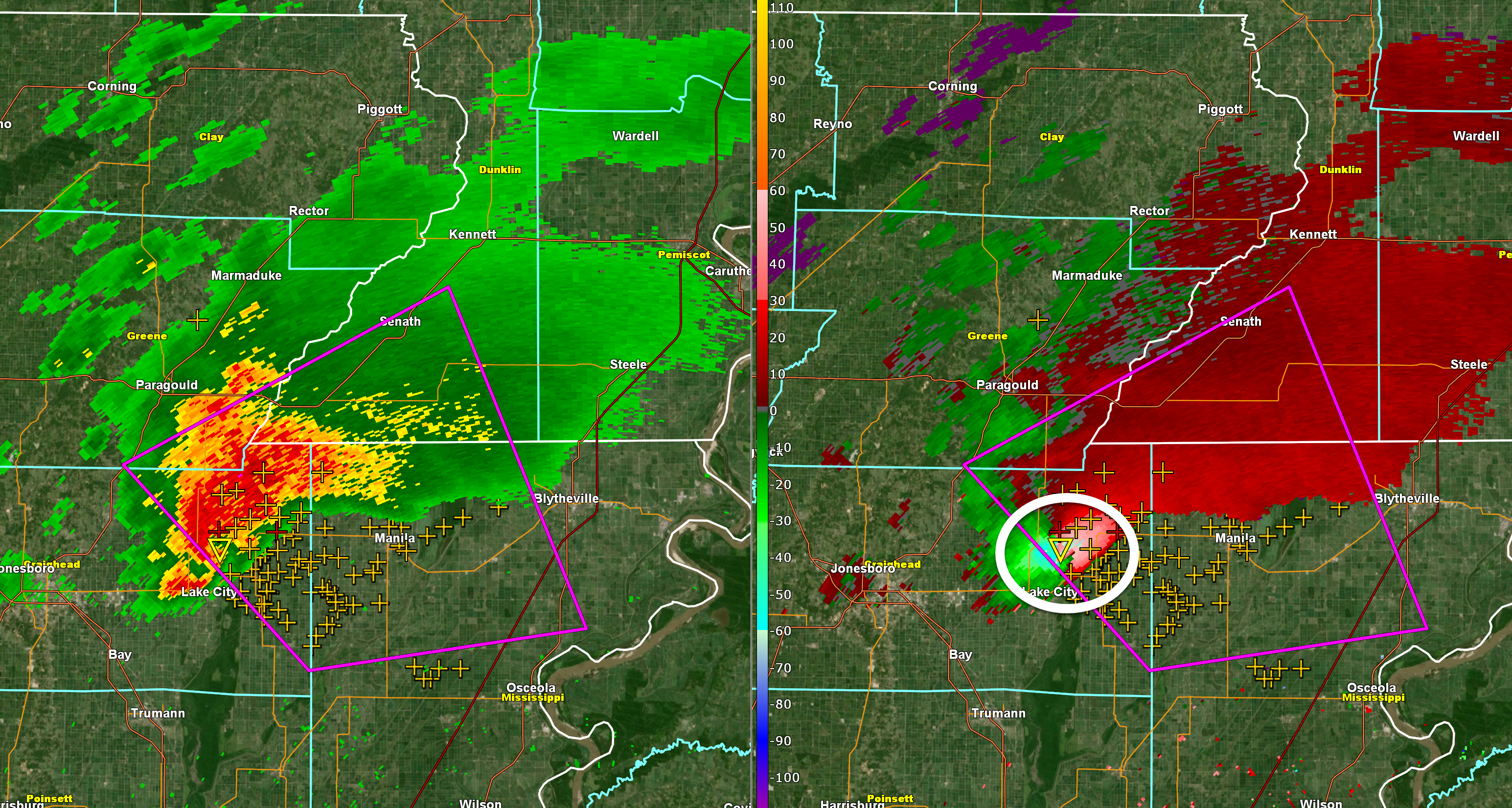
A new tornadic supercell was moving through Jonesboro, Arkansas. Another tornado may move into the Bootheel. Be alert.
8:34 PM
BULLETIN - EAS ACTIVATION REQUESTED
TORNADO WARNING
NATIONAL WEATHER SERVICE PADUCAH KY
829 PM CST FRI DEC 10 2021

THE NATIONAL WEATHER SERVICE IN PADUCAH HAS ISSUED A

* TORNADO WARNING FOR...
  FULTON COUNTY IN WESTERN KENTUCKY...
  HICKMAN COUNTY IN WESTERN KENTUCKY...
  SOUTH CENTRAL MISSISSIPPI COUNTY IN SOUTHEASTERN MISSOURI...

* UNTIL 930 PM CST.

* AT 829 PM CST, A CONFIRMED LARGE AND EXTREMELY DANGEROUS TORNADO
  WAS LOCATED OVER TIPTONVILLE, OR NEAR REELFOOT LAKE STATE PARK,
  MOVING NORTHEAST AT 55 MPH.

  THIS IS A PARTICULARLY DANGEROUS SITUATION. TAKE COVER NOW!

  HAZARD...DAMAGING TORNADO.

  SOURCE...LAW ENFORCEMENT CONFIRMED TORNADO.

  IMPACT...YOU ARE IN A LIFE-THREATENING SITUATION. FLYING DEBRIS
           MAY BE DEADLY TO THOSE CAUGHT WITHOUT SHELTER. MOBILE
           HOMES WILL BE DESTROYED. CONSIDERABLE DAMAGE TO HOMES,
           BUSINESSES, AND VEHICLES IS LIKELY AND COMPLETE
           DESTRUCTION IS POSSIBLE.

* THE TORNADO WILL BE NEAR...
  HICKMAN AROUND 855 PM CST.
  CAYCE AROUND 905 PM CST.
  CLINTON AROUND 910 PM CST.
  FULGHAM AROUND 915 PM CST.

OTHER LOCATIONS IMPACTED BY THIS TORNADIC THUNDERSTORM INCLUDE
BOUNDURANT.
8:30 PM
Southern Caldwell County, Northern Trigg County. Hopkins County. Northern Christian County.
Radar showed rotation near Cobb, Kentucky in far southern Caldwell County. This storm could produce a tornado.
Seek shelter now.
.
8:26 PM
Extreme NE Christian County. Extreme southeast Hopkins County.
Tornado warning. A tornado was indicated by radar 13 miles SE of Madisonville, KY. The storm is moving E NE at 50 mph.
Seek shelter if you are in this warning.
Turn on local media, as well. Numerous storms are likely tonight.
.
8:18 PM
Pemiscot Counties in southeast Missouri. Far southern New Madrid County.
Lake and Obion Counties.
Fulton County, Kentucky.
The tornado is now crossing the Mississippi River into northwest Tennessee. Lake County, Tennessee and Obion County, Tennessee, move to your safe plan at this time.
A large and dangerous tornado was on the ground moving east/northeast at 50 mph.
This is a very dangerous storm. It may clip far southern New Madrid County.
Radar https://weatherobservatory.com/radar_pbluff.htm
.
8:14 PM
Pemiscot Counties in southeast Missouri. Far southern New Madrid County.
Lake and Obion Counties.
Fulton County, Kentucky.
A large and dangerous tornado was on the ground in the Missouri Bootheel near Caruthersville, Missouri, moving east/northeast at 50 mph. It is moving through Pemiscot County, at this time. Seek shelter NOW.
This is a very dangerous storm. It will soon enter northwest Tennessee. It may clip far southern New Madrid County.
Radar https://weatherobservatory.com/radar_pbluff.htm
.
8:04 PM
Pemiscot Counties in southeast Missouri. Far southern New Madrid County.
Lake and Obion Counties.
Fulton County, Kentucky.
A large and dangerous tornado was on the ground in the Missouri Bootheel near or north of Steele, Missouri, moving east/northeast at 50 mph. It is moving through Pemiscot County, at this time. Seek shelter NOW.
This is a very dangerous storm.
Radar https://weatherobservatory.com/radar_pbluff.htm
.
8:01 PM
Southern McLean and northern Muhlenberg County.
Tornado warning has expired. Severe storms have left the county. Monitor through the night. More storms are possible.
.
7:48 PM
Southern McLean and northern Muhlenberg County.
An intense thunderstorm continues to move through McLean and Muhlenberg Counties. There has occasionally been rotation with this thunderstorm. Be weather aware as this storm continues to move through your counties.
Seek shelter if you are in the path of this storm. A tornado is possible.
.
7:43 PM
SPECIAL WEATHER STATEMENT
NATIONAL WEATHER SERVICE PADUCAH KY
FRI DEC 10 2021

KYZ001-002-006-008-009-110315-
FULTON-HICKMAN-GRAVES-MARSHALL-CALLOWAY-
INCLUDING THE CITIES OF HICKMAN, CLINTON, MAYFIELD, BENTON,
AND MURRAY
733 PM CST FRI DEC 10 2021

...SPECIAL WEATHER STATEMENT...

AROUND 730 PM, A STORM PRODUCING A TORNADO WAS MOVING INTO THE
MISSOURI BOOTHEEL REGION. IF IT CONTINUES ITS CURRENT TRACK, IT
WILL REACH PORTIONS OF FULTON, HICKMAN, AND GRAVES COUNTIES IN
WEST KENTUCKY, WITH THE TIME FRAME OF CONCERN FROM 845 PM TO 930
PM.

THIS STORM WILL LIKELY MAINTAIN ITS INTENSITY, AND COULD VERY WELL
CONTINUE TO PRODUCE A TORNADO. SO NOW IS THE TIME TO PREPARE AND
BE READY TO TAKE SHELTER SHOULD A WARNING BE ISSUED.
7:41 PM
Dunklin and Pemiscot Counties in southeast Missouri.
Lake and Obion Counties.
A large and dangerous tornado was on the ground in the Missouri Bootheel near Hornersvile, Missouri, moving northeast at 45 mph.
Seek shelter if this storm approaches your area. This is a dangerous storm.
Radar https://weatherobservatory.com/radar_pbluff.htm
.
7:38 PM
Southern McLean and northern Muhlenberg County.
A storm with rotation was in eastern Hopkins County moving out of the county. The storm is entering southern McLean and northern Muhlenberg Counties. This storm is moving E NE at 50 mph.
Seek shelter if you are in the path of this storm. A tornado is possible.
.
7:33 PM
Dunklin and Pemiscot Counties in southeast Missouri.
Lake and Obion Counties.
A large and dangerous tornado was on the ground in NE AR near Leachville, Arkansas, moving northeast at 45 mph.
This tornado, if it remains on the ground, will move into southern Dunklin County and eventually Pemiscot Counties.
Seek shelter if this storm approaches your area. This is a dangerous storm.
Radar https://weatherobservatory.com/radar_pbluff.htm
.
7:27 PM
Southern Hopkins, Southern McLean, and northern Muhlenberg County.
A storm with rotation was in eastern Hopkins County (south/southeast of Madisonville). This storm is moving E NE at 50 mph.
Seek shelter if you are in the path of this storm. A tornado is possible.
.
7:22 PM
Dunklin and Pemiscot Counties in southeast Missouri.
A large and dangerous tornado was on the ground in NE AR nearing Leachville, Arkansas, moving northeast at 45 mph.
This tornado, if it remains on the ground, will move into southern Dunklin County and eventually Pemiscot Counties.
Seek shelter if this storm approaches your area. This is a dangerous storm.
Radar https://weatherobservatory.com/radar_pbluff.htm
.
7:18 PM
Dunklin and Pemiscot Counties in southeast Missouri.
A large and dangerous tornado was on the ground in NE AR near Bay, moving northeast at 45 mph.
This tornado, if it remains on the ground, will move into southern Dunklin County and eventually Pemiscot Counties.
Seek shelter if this storm approaches your area. This is a dangerous storm.
Radar https://weatherobservatory.com/radar_pbluff.htm
.
7:16 PM
Southern Hopkins, Southern McLean, and northern Muhlenberg County.
A storm with rotation was near or nearing Nortonville, KY. This storm is moving E NE at 50 mph.
Seek shelter if you are in the path of this storm. A tornado is possible.
.
7:00 PM
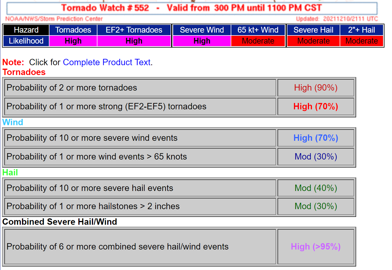
Tornado risk increasing.
Click to enlarge the image.
6:58 PM
Calloway County
The rotation that moved into southeast Calloway County has weakened.
Stay alert tonight, because additional storms are likely going to impact the area.
.
6:55 PM
Dunklin and Pemiscot Counties in southeast Missouri.
A tornadic supercell storm was located in northeast Arkansas. It will soon move into southern Dunklin and Pemiscot Counties. This storm has a history of producing tornadoes.
Be prepared to seek shelter if this storm approaches your area.
Several rounds of storms will likely impact the region tonight. Be alert.
Radar https://weatherobservatory.com/radar_pbluff.htm
.
6:46 PM
.
6:43 PM
Henry County, TN. Southeast Calloway County. Trigg County.
Radar showed a storm with rotation over Puryear, TN. This storm is moving northeast at 40 mph. The storm could strengthen and if the rotation strengthen then there could be concerns.
Be weather aware as this storm moves northeast.
.
6:41 PM
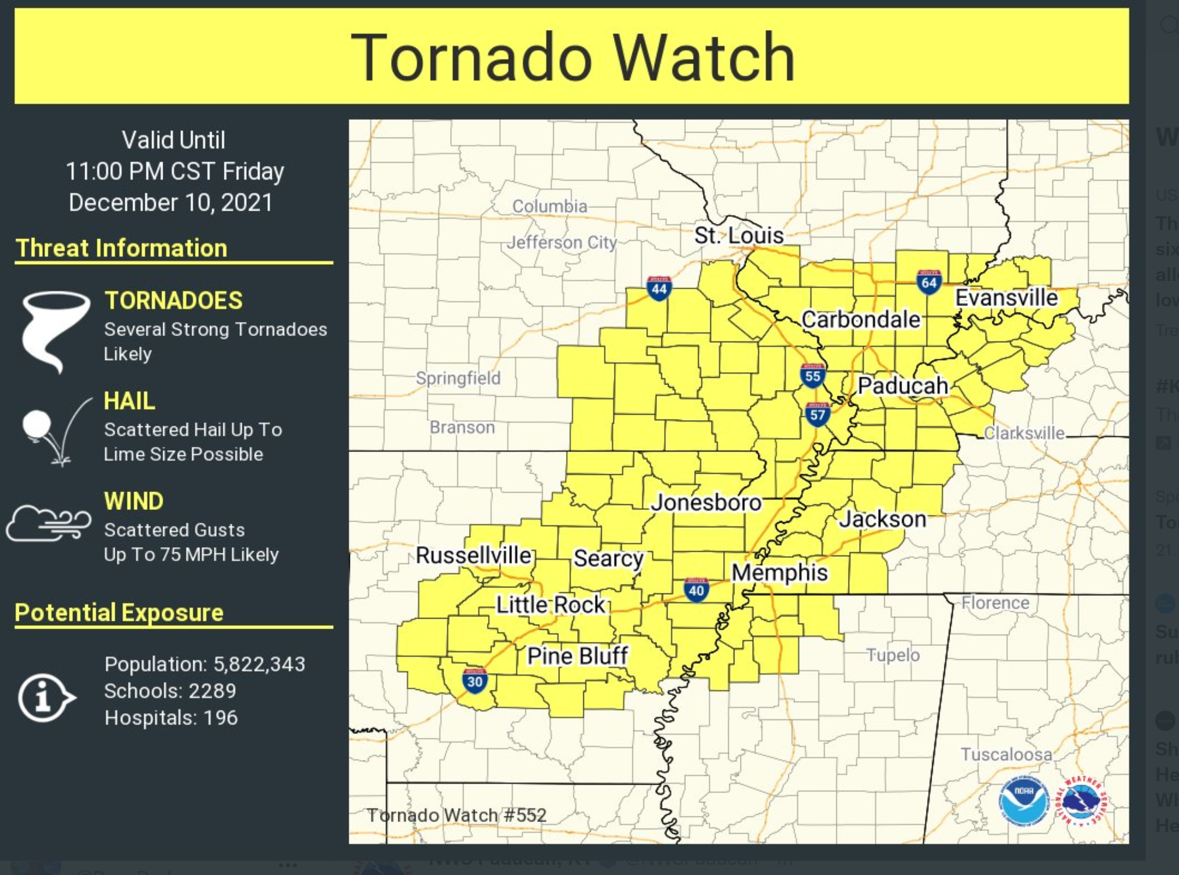
New tornado watch for the rest of the area.
.
6:32 PM
Henry County, TN. Southeast Calloway County.
Radar showed a storm with rotation southwest of Puryear, TN. This storm is moving northeast at 40 mph. The storm could strengthen and if the rotation strengthen then there could be concerns.
Be weather aware as this storm moves northeast.
.
6:32 PM
Henry County, TN. Southeast Calloway County.
Radar showed a storm with rotation southwest of Puryear, TN. This storm is moving northeast at 40 mph. The storm could strengthen and if the rotation strengthen then there could be concerns.
Be weather aware as this storm moves northeast.
.
6:16 PM
Fulton County, Kentucky.
Dunklin, Pemiscot, New Madrid Counties in southeast MO.
Lake and Obion Counties in northwest Tennessee.
A tornadic supercell storm was located in northeast Arkansas. It will likely move into the Missouri Bootheel and northwest Tennessee over the next hour or so. Eventually into western Kentucky.
This storm has a history of rotation and the atmosphere is favorable for tornadoes.
Be weather aware and alert for possible tornado warnings.
Several rounds of storms will likely impact the region tonight. Be alert.
.
6:12 PM
Union, Webster, and Henderson Counties in western Kentucky. Thunderstorms are forming and moving through Union and Webster Counties.
These storms are currently not severe, but the atmosphere is favorable for strengthening. Let’s keep an eye on these storms as they move northeast at 40 to 50 mph. They are moving fast.
Stay weather aware. Multiple rounds of storms are likely to form overnight.
.
6:06 PM
Caldwell, Lyon, and northern Trigg Counties.
A tornado warned cell was approaching from the southwest. At 6:06 PM it was entering southern Marshall County. The storm is moving northeast at 40 to 50 mph. If the storm maintains its strength and the rotation continues then tornado warnings will need to be issued for portions of the above mentioned counties.
Be weather aware.
.
6:04 PM
Tornado warning for north/northwest Calloway County, and Marshall County. Until 6:15 PM.
The tornado is about to move into the Hardin, Kentucky area. That is in southern Marshall County. Anyone in or near the path should seek shelter.
Radar shows rotation in northern Calloway County.
This storm will soon enter southern Marshall County.
This is a radar indicated tornado.
This storm is moving northeast at 40 to 50 mph.
.
5:58 PM
Tornado warning expired for Graves County.
Continues for…
Tornado warning for north/northwest Calloway County, and Marshall County. Until 6:15 PM.
Radar shows rotation in northern Calloway County. The rotation was just northeast of Kirksey, KY in Calloway County. Anyone in or near the path should seek shelter.
This storm will soon enter southern Marshall County.
This is a radar indicated tornado.
This storm is moving northeast at 40 to 50 mph.
.
5:50 PM
Tornado warning for southeast Graves County, northwest Calloway County, and Marshall County. Until 6:15 PM.
Radar shows rotation about to cross into Calloway County from Graves County. The Kirksey area is in the path of this storm. Anyone in or near the path should seek shelter.
This is a radar indicated tornado.
This storm is moving very fast.
.
5:47 PM
Tornado warning for southeast Graves County, northwest Calloway County, and Marshall County. Until 6:15 PM.
Radar shows rotation near Farmington in Graves County. Moving northeast at 50 mph.
This storm will soon exit Graves County. Seek shelter until the storm passes your location.
This is a radar indicated tornado.
This storm is moving very fast.
..
5:42 PM
Tornado warning for southeast Graves County, northwest Calloway County, and Marshall County. Until 6:15 PM.
Radar shows rotation between Cooksville and Farmington in Graves County. Moving northeast at 50 mph. This is a radar indicated tornado.
This storm is moving very fast.
.
5:36 PM
Tornado warning for southeast Graves County, northwest Calloway County, and Marshall County. Until 6:15 PM.
Radar shows rotation near Tri-City and Cooksville in Graves County. Moving northeast at 50 mph. This is a radar indicated tornado.
This storm is moving very fast.
.
4:52 PM
Special Weather Statement
.
4:05 PM
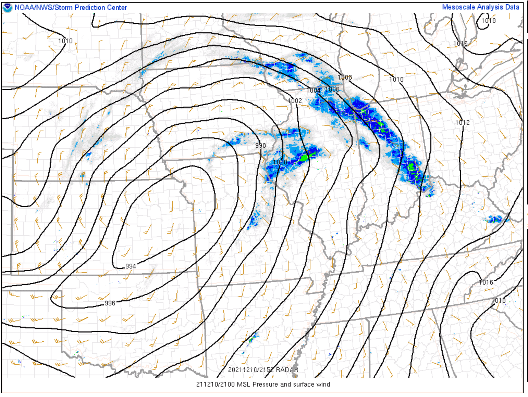
A deep area of low pressure was centered over Kansas this evening. This low will rapidly move northeast tonight. That will help in the development of severe thunderstorms in our local area.
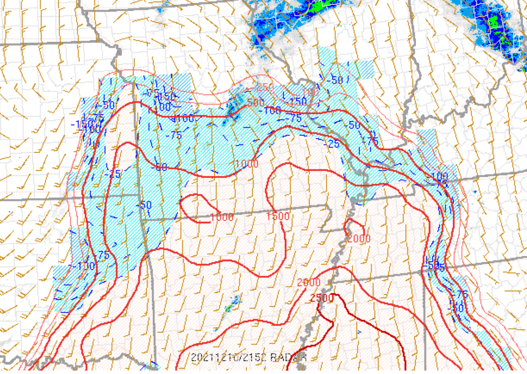
You can see the low on this image. Those black lines are equal lines of pressure. Barometric pressure. Your home barometer will be falling tonight as the system develops.
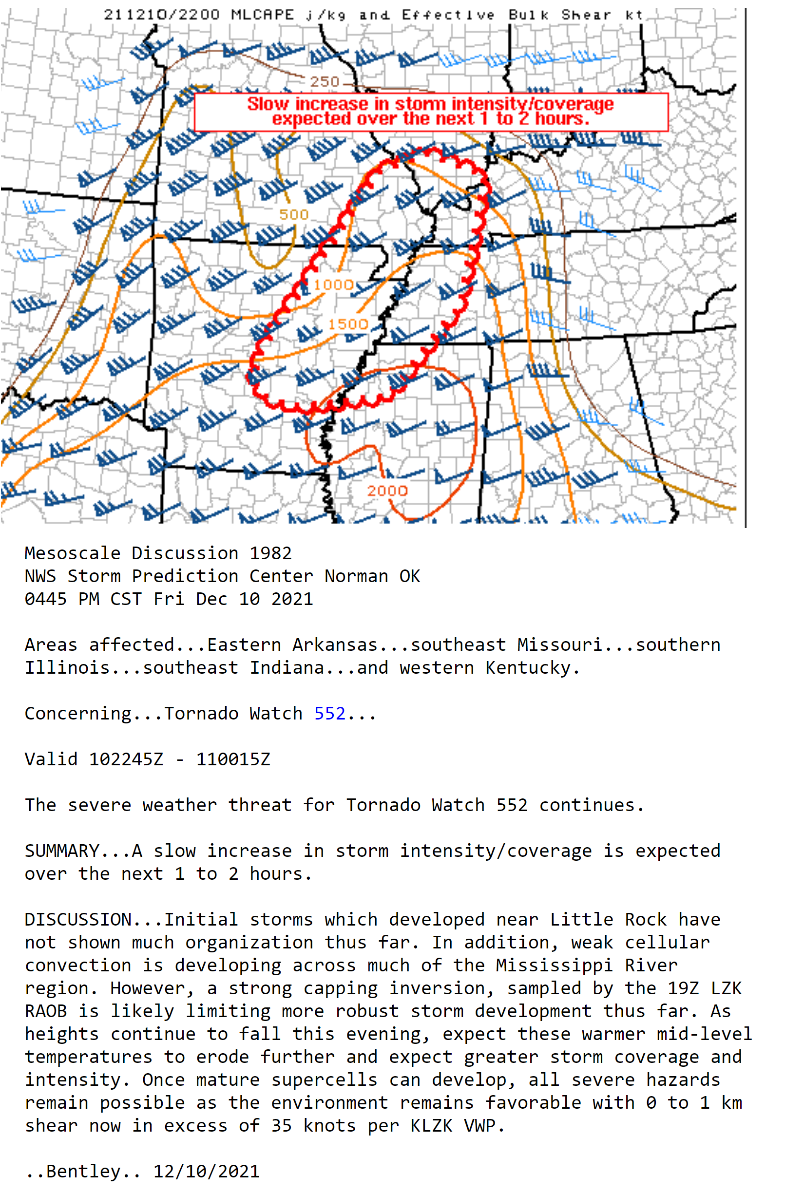
CAPE values (energy) are quite high for December. Second image. CAPE values of 1000 to 2000 are indicated. That just means there is a lot of unstable air in the atmosphere.
.
4 PM
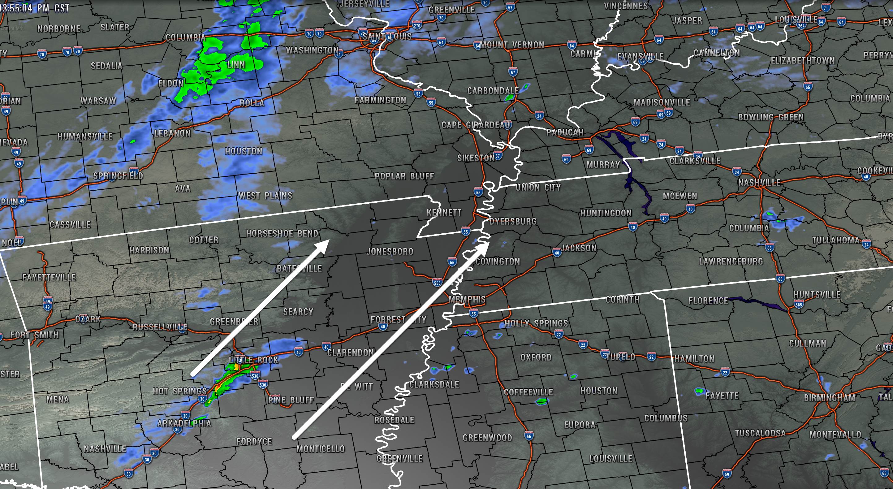
Storms are forming near Little Rock, AR. They are moving northeast at 60 mph. Additional storms are likely to form over the next few hours further northeast of there into our region.
Storms will be zipping along tonight. Be aware.
.
3:15 PM
.
3:10 PM
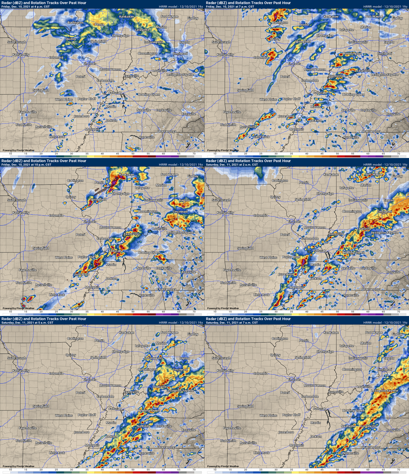
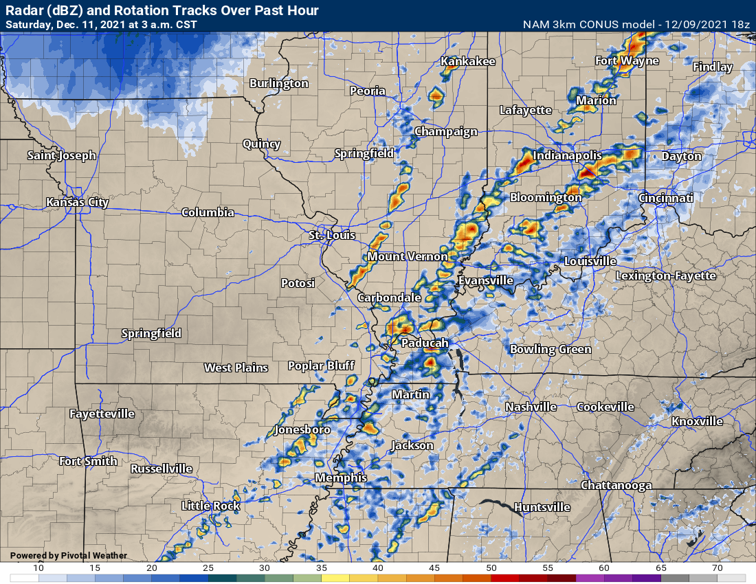
Latest future-cast radar.
Do not get caught up in following every storm. Take the GENERAL idea that several rounds of storms will be possible.
Severe storms tonight are almost certain. Be prepared and aware, as always.
.
1:30 PM
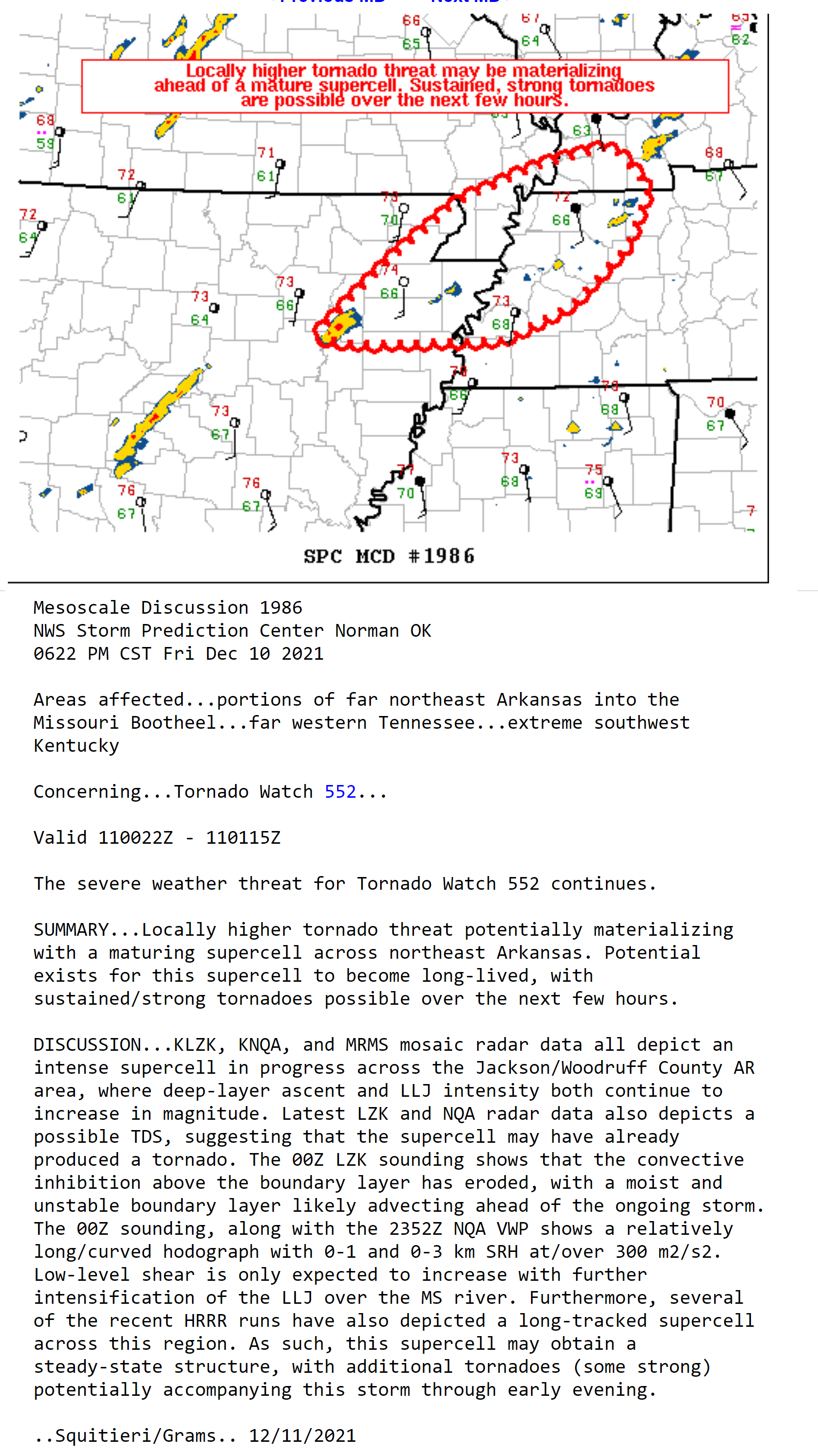
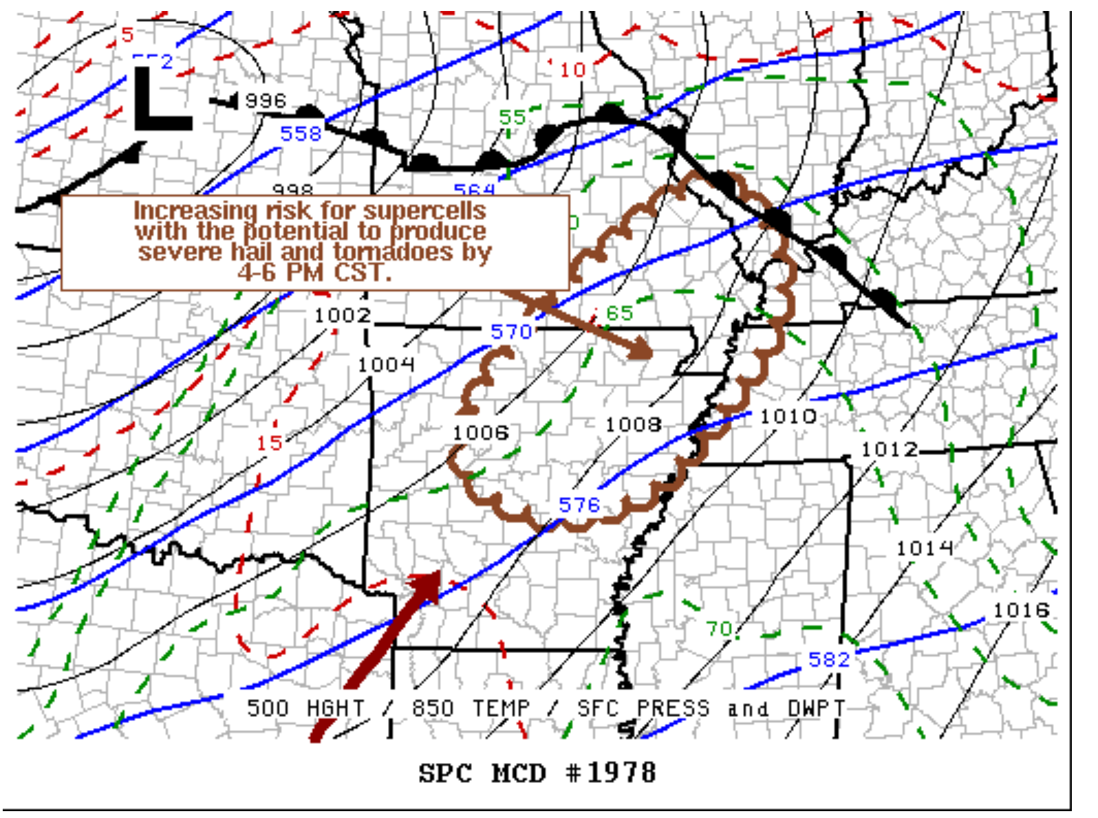
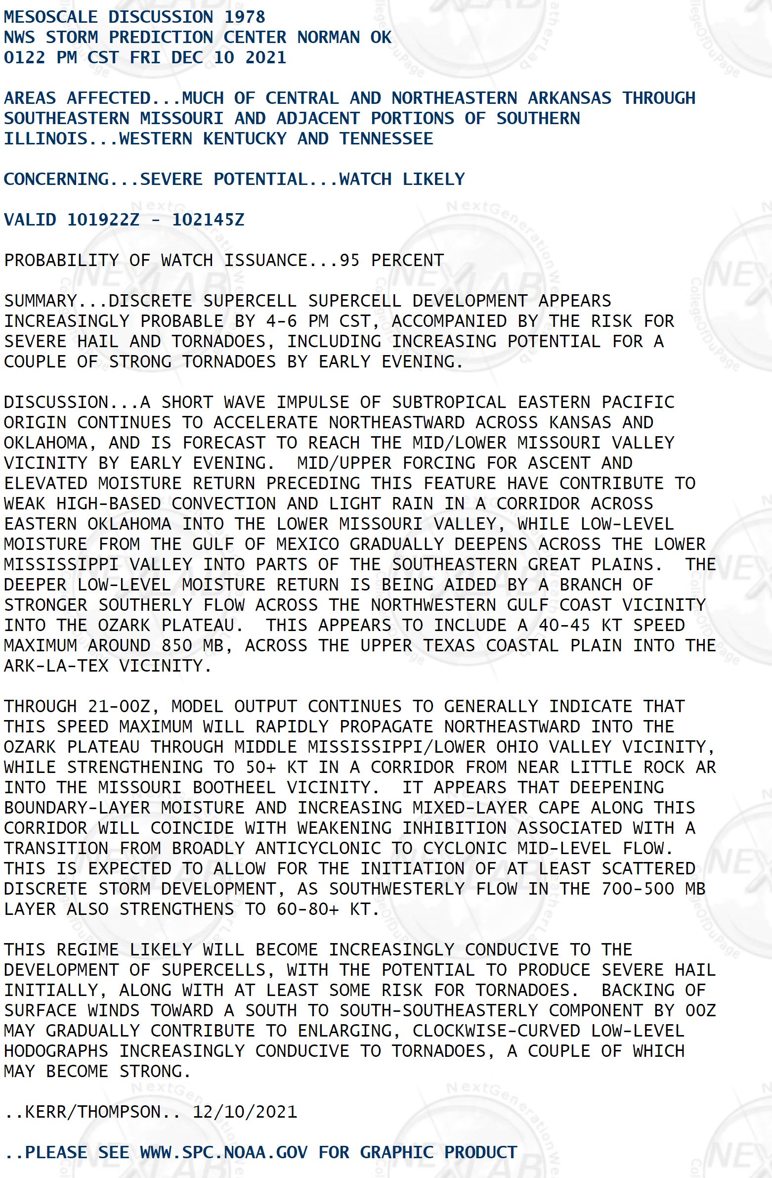
Meso-scale discussion from the SPC
This is a special weather statement from NOAA. It goes into meteorological detail about what is expected to happen over the next few hours.
Click the image to enlarge it (the text).
.
10:30 AM
Focus on the forecast and not the colors. The forecast is for severe storms tonight. Some storms could produce damaging wind, hail, and tornadoes.
10 AM
All of the morning data is in. They all show thunderstorms forming this evening and lasting well into the night.
Stay weather aware throughout this event.
More details below.
.
8:30 AM
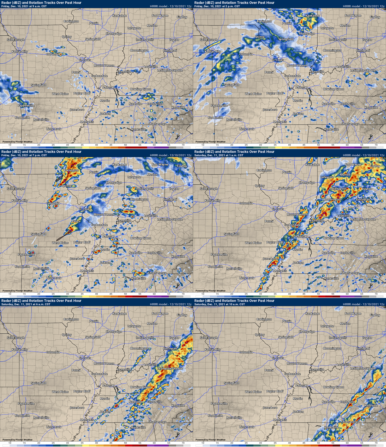
Here is the latest Hrrr model update.
You can see that the CAP does break and numerous thunderstorms form this evening/tonight. If this is correct then the risk of severe weather is significant.
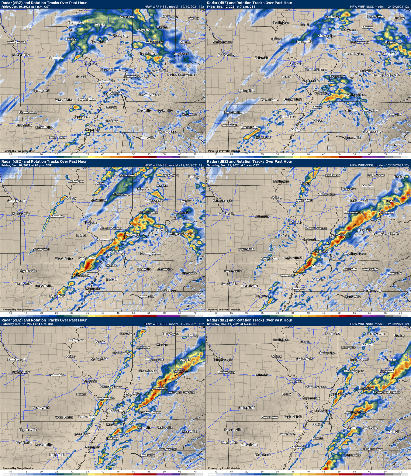
Don’t focus on the exact location of an individual storm. Take the general idea that storms will develop and impact our region.
Here is the WRF model (another high-resolution model)
.
7 AM Friday
Good morning, everyone.
Advice for today.
- Have multiple ways of receiving your severe weather information. Don’t rely on just one.
- Make sure your Beau Dodson WeatherTalk app is on. Open it up.
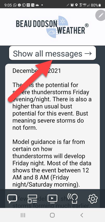
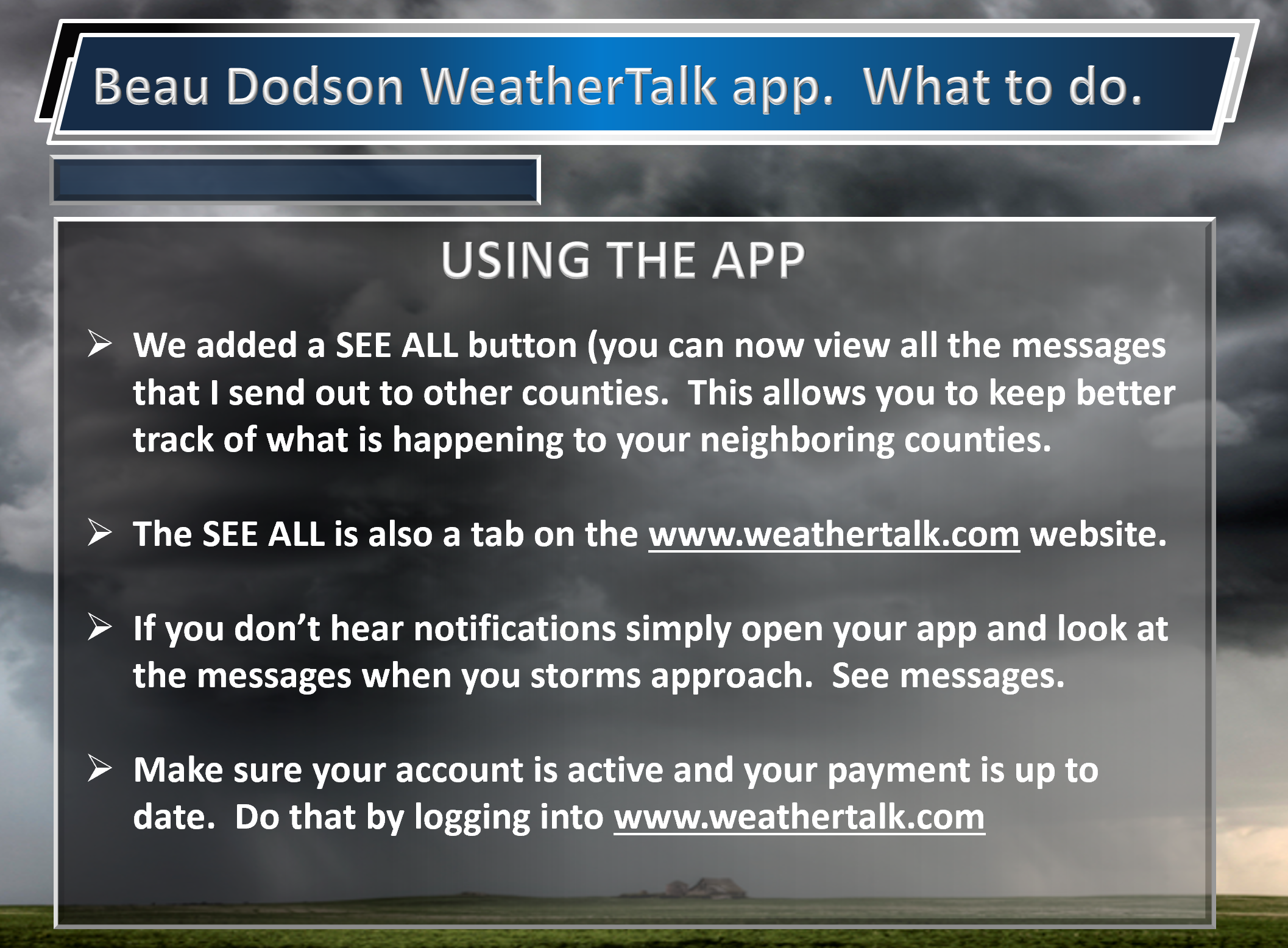
- If you think you are not receiving notifications then simply open your app and look at my messages. We added a SEE ALL tab to the app and the www.weathertalk.com website. See every message that I send out to every county.
- Storms will move fast. You don’t have to wait for a warning to seek shelter. If a neighboring county has a tornado warning then you can go ahead and go to your safe place, as well.
- This could be a high-end severe weather event if the CAP breaks. Numerous warnings may have to be issued. It may be hard to keep up with it (if this happens). Be weather aware tonight.
We added a SEE ALL tab to the app. You can now see every severe weather message for every county.
.
Severe weather parameters continue to increase. Wind fields are extreme, moisture fields are extreme, and there still is a CAP/lid to deal with.
This is a complicated forecast. The only question as to whether we experience severe thunderstorms and tornadoes will be the CAP. Scroll down for more information on the CAP.
Here was a short video, from another meteorologist, that I posted yesterday. It explains the CAP/lid.
This makes for a tricky forecast.
I have been talking to many of this regions meteorologists and we all have the same concerns. When does the CAP break and what does that look like (if and when it happens).
The bulk of this event should be after dark. It is possible a few thunderstorms form early in the evening. The bulk of the data, however, indicates that the thunderstorm activity will become more numerous by mid to late evening. If that happens, then thunderstorms should continue into early Saturday morning (midnight into 5 am).
This is a particularly dangerous weather situation. Many of our severe weather parameters are pegged out.
Be prepared to seek shelter if thunderstorms form.
Thunderstorms will likely be moving at speeds in excess of 50 mph. That will not give you much time to seek shelter.
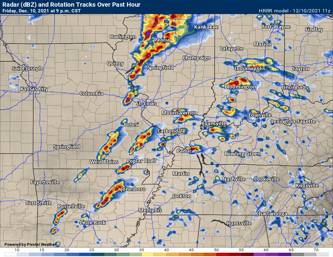
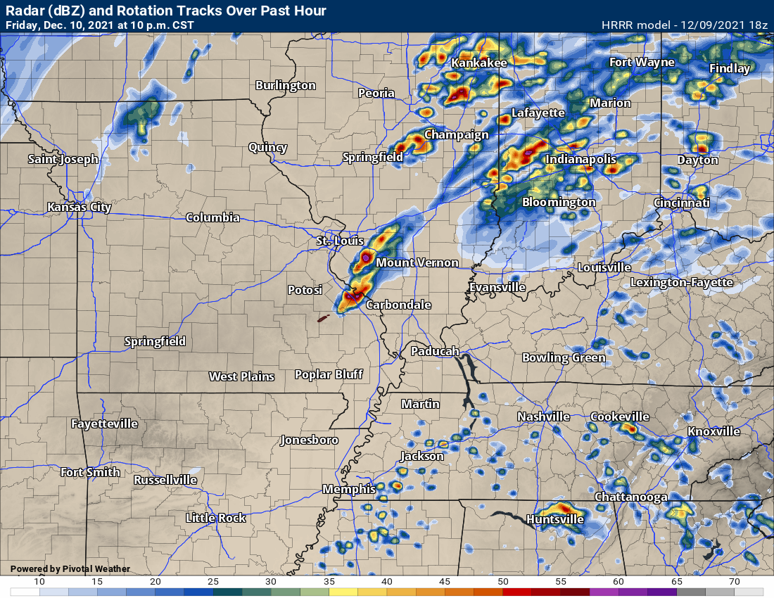
The Hrrr model has been trending towards a bigger event. Check out this static image. This is the 9 PM future-cast radar from the Hrrr model. It does break the cap and numerous supercells form.
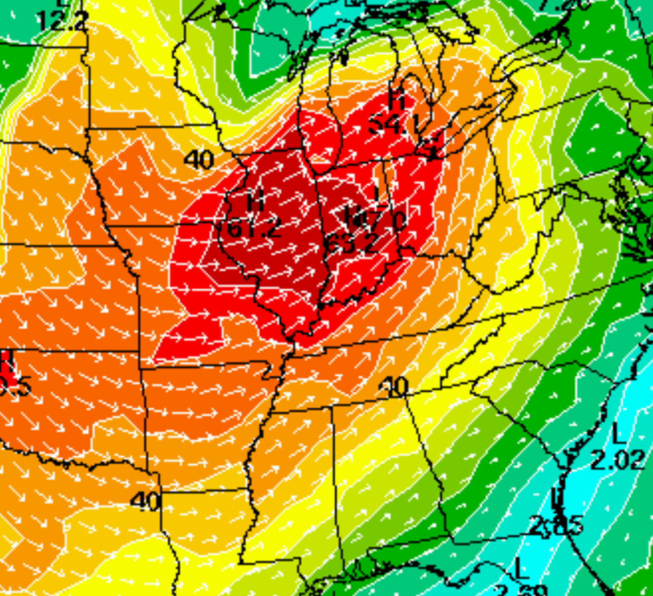
Here is the NAM model storm motion map. It is hard to read, but you can see 67 knots in central Illinois. Our region will likely be in the 50+ knot zone. Those are very fast storm speeds. They will be moving east/northeast.
If there is a warning to your west/southwest then be prepared to seek shelter. You don’t have to wait until a warning is issued if you feel threatened by a storm.
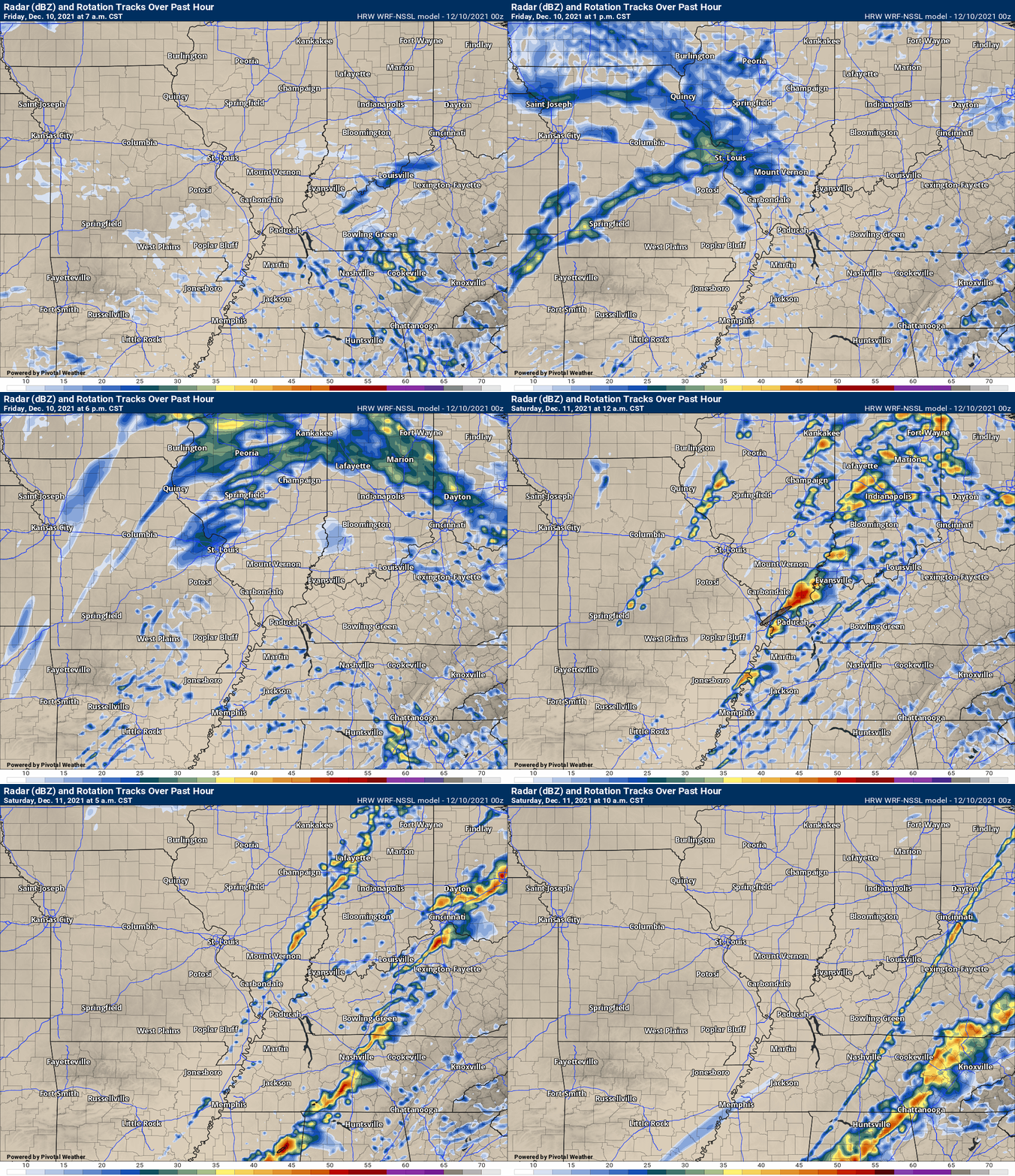
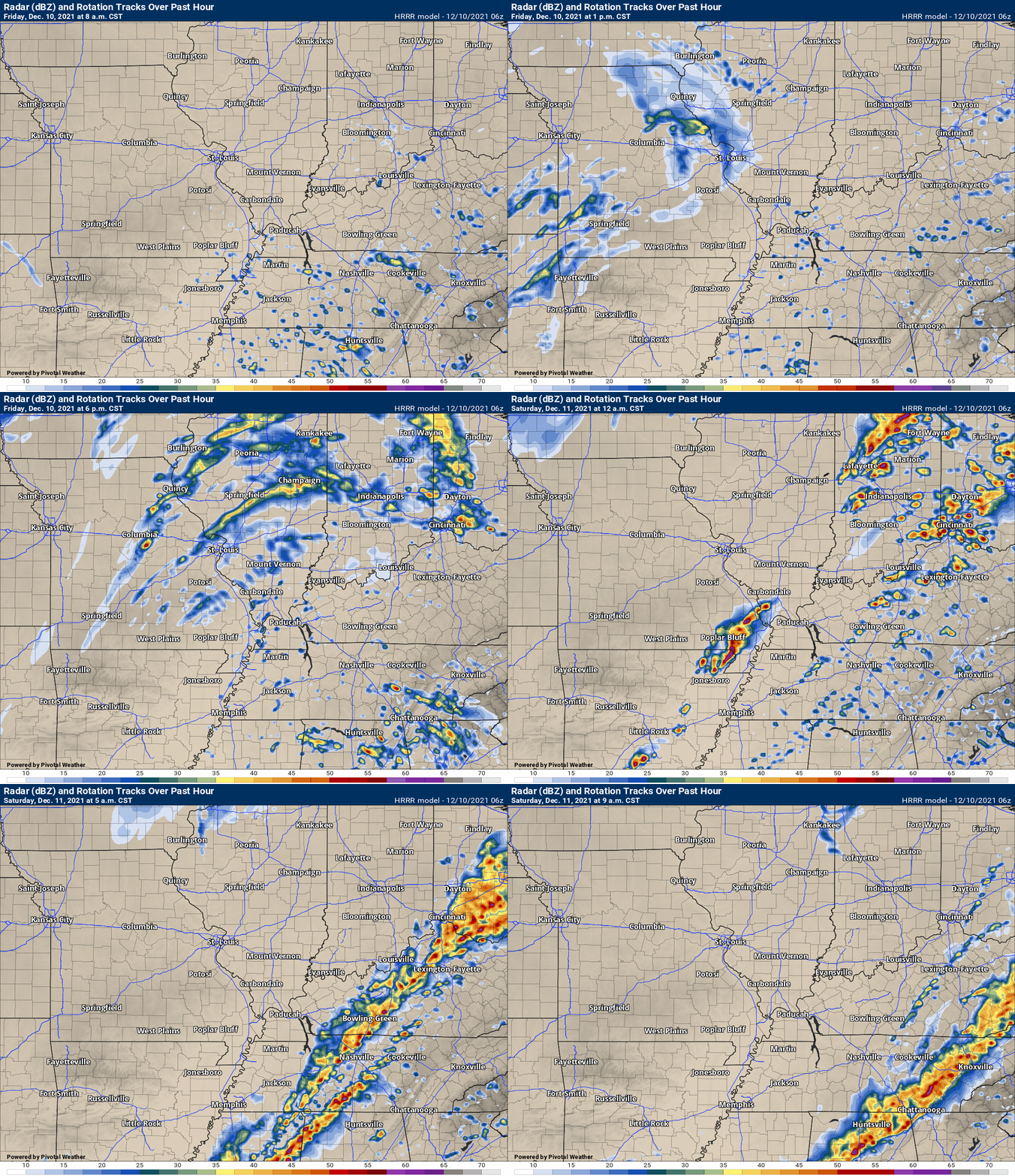
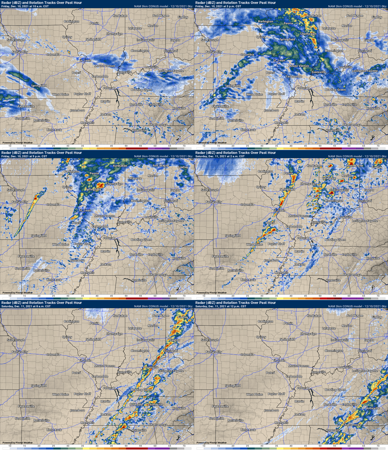
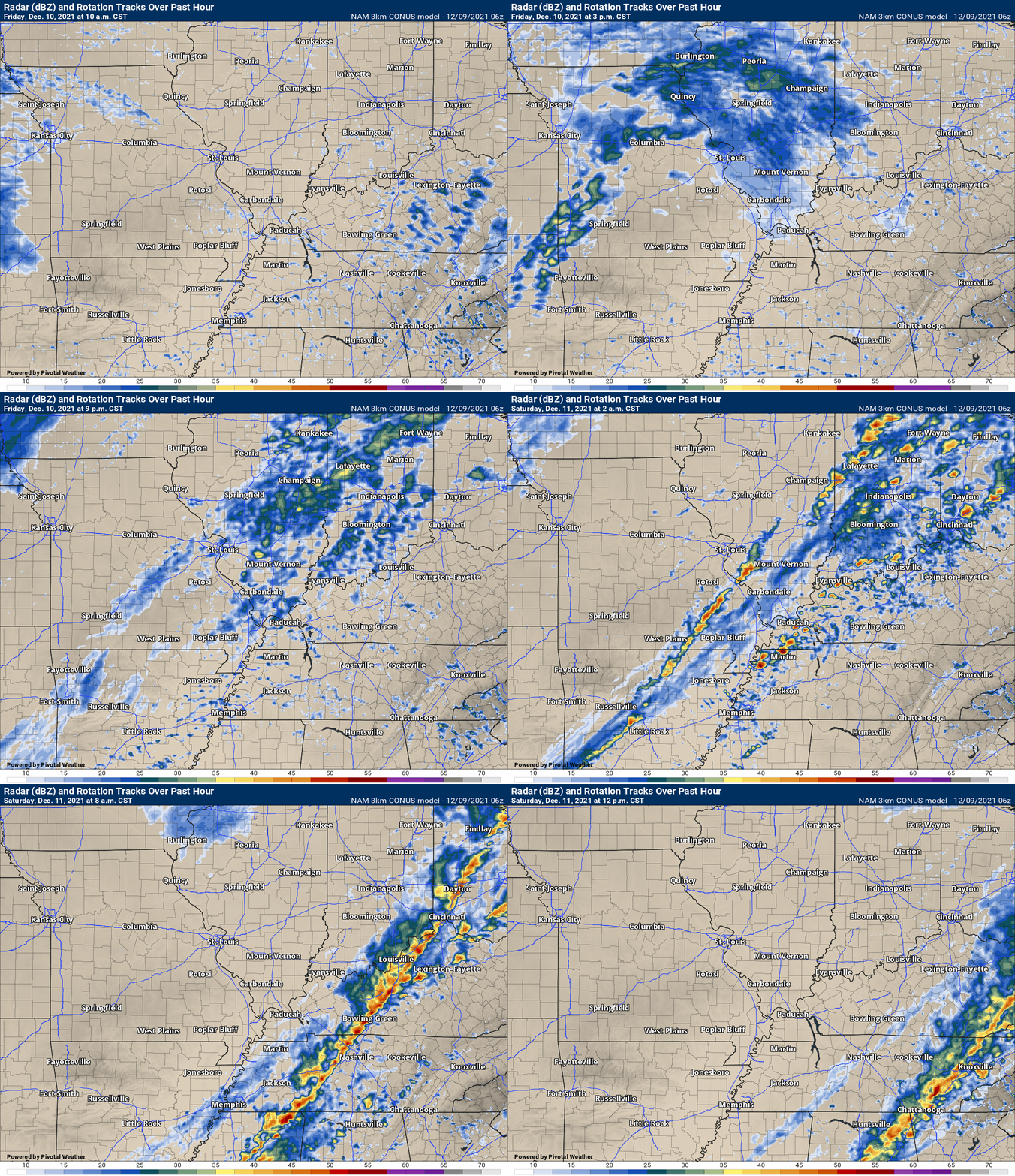
This morning’s future-cast radars show how the different models are handling this set-up.
This animation is the Storm Prediction Center WRF model.
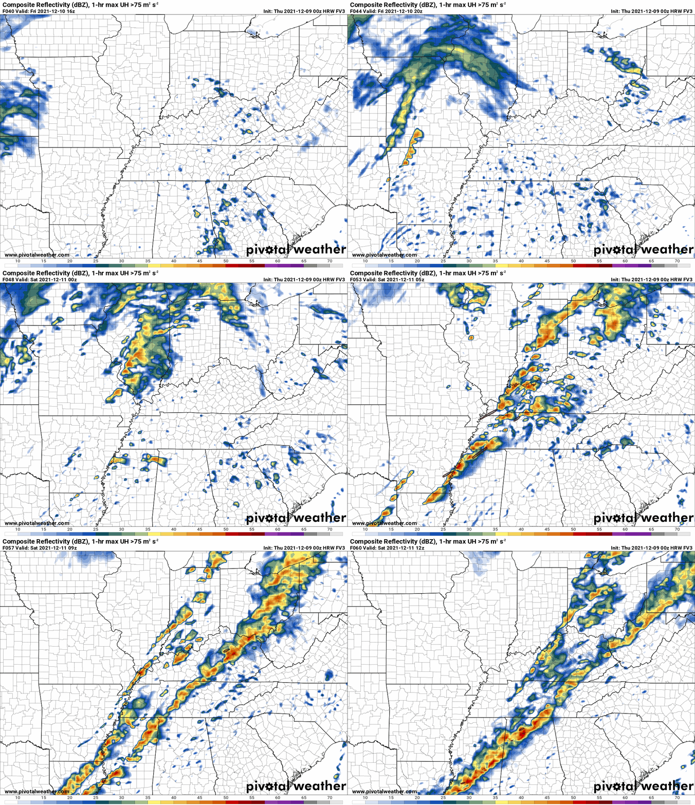
This animation shows you what radar might look like as the next system pulls through the region. It is a future-cast radar.
Time-stamp upper left. Click the animation to enlarge it.
.
This animation is the Hrrr short-range model.
This animation shows you what radar might look like as the next system pulls through the region. It is a future-cast radar.
Time-stamp upper left. Click the animation to enlarge it.
.
.This animation is the higher-resolution 3K NAM American Model.
3 PM Thursday update
Afternoon models are showing supercell thunderstorms forming tomorrow evening/night. These area scattered severe thunderstorms.
There are two types of severe weather modes. Squall lines. Solid lines of thunderstorms. Supercell thunderstorms. They tend to be more isolated and scattered.
Higher end severe weather is often times associated with supercell thunderstorms.
We still have to monitor the CAP tomorrow night in case it does hold and storms don’t form. We can’t count on that happening, but it is something I will be monitoring closely.
Here are some of the afternoon models.
Don’t get hung up on WHERE they show storms. Just know that storms could form in this type of atmosphere and quickly become severe.
Also, the timing may vary with this event. Don’t get too caught up in the exact timing. Know that tomorrow night, at any given point, storms could form in the area.
Hrrr model at 10 PM Friday night. You can see a few supercell thunderstorms in southeast Missouri and southern Illinois.
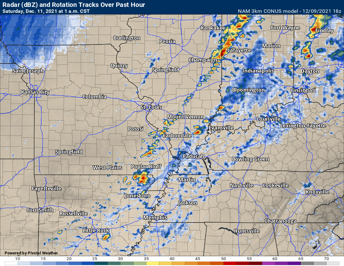
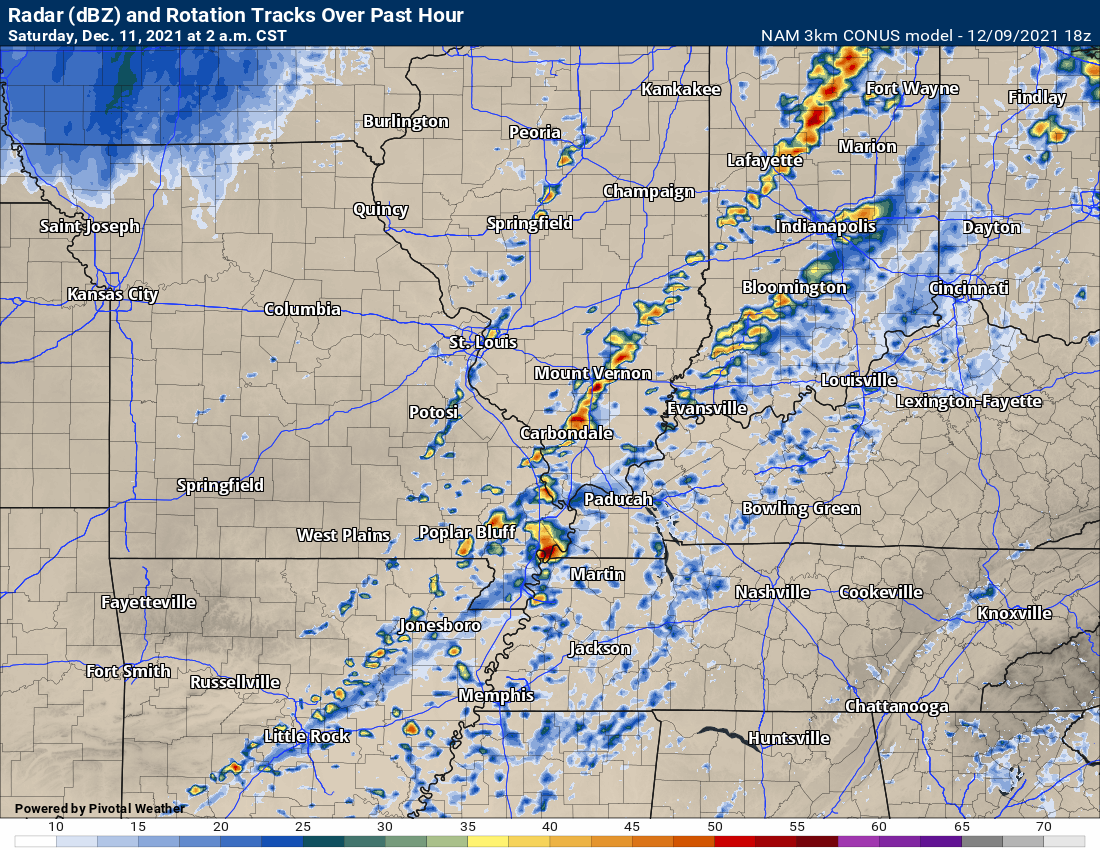
Another model, the NAM, shows scattered supercell thunderstorms, as well.
1 AM
2 AM
3 AM
11 AM update
Many models are showing the CAP holding strong tomorrow and tomorrow night. This would greatly reduce our risk of severe weather. The question comes down to whether or not the CAP holds. Scroll down the blog to read more about the CAP and the forecast.
.
.
.
.
8 AM update
** SEVERE WEATHER EVENT POSSIBLE FRIDAY AND FRIDAY NIGHT **
There will be a strong CAP Friday/Friday night. This could help keep thunderstorms from forming. There remain questions about how this event unfolds or does not unfold. It is possible we avoid a larger severe weather event if the CAP holds.
SUBSCRIBERS: Download the WeatherTalk app.
The app is for subscribers. Subscribe at www.weathertalk.com/welcome then go to your app store and search for WeatherTalk
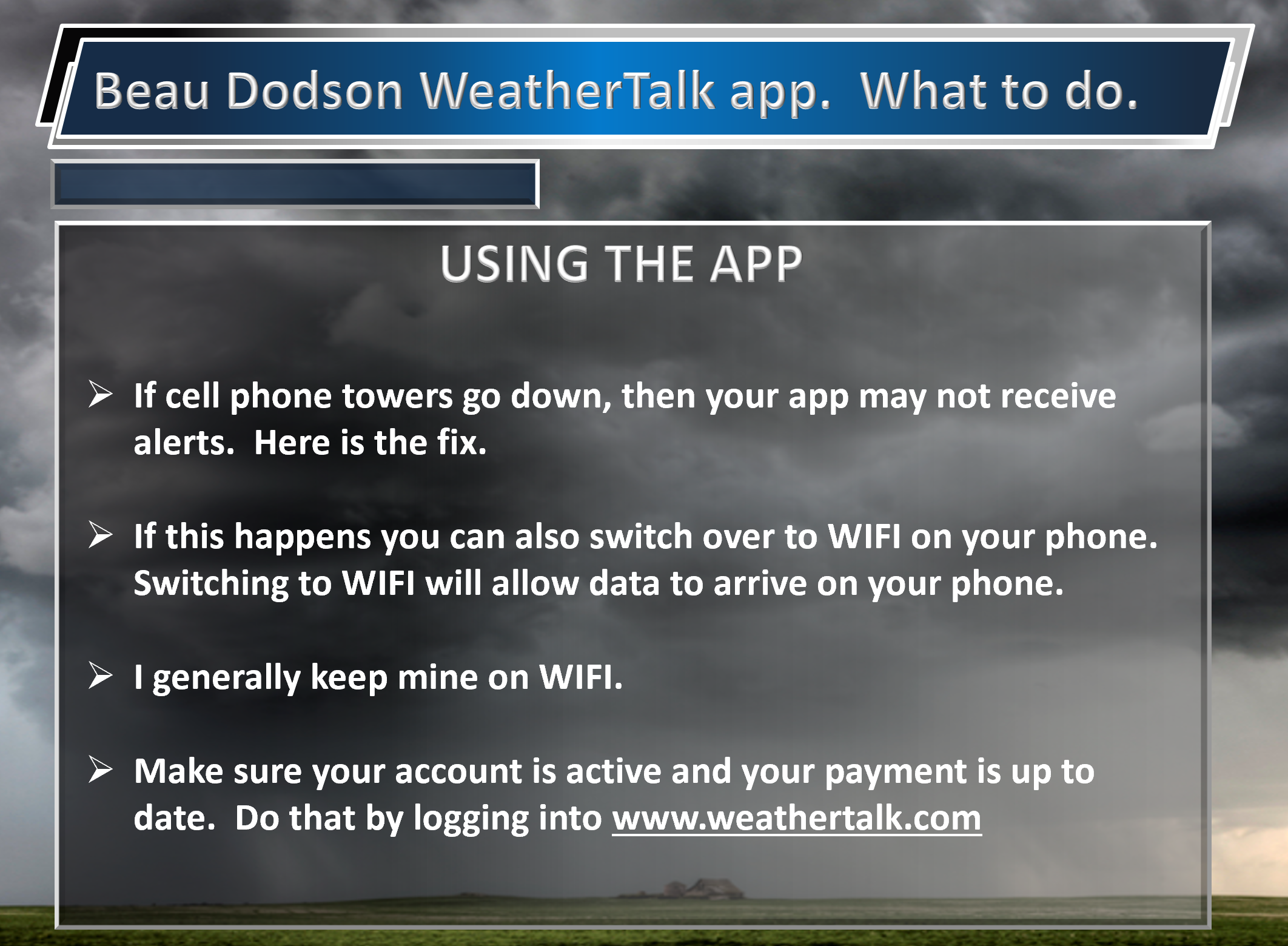
Subscribers, PLEASE USE THE APP. ATT and Verizon are not reliable during severe weather. They are delaying text messages.
The app is under WeatherTalk in the app store.
Apple users click here
Android users click here
.
.
Today through Friday morning.
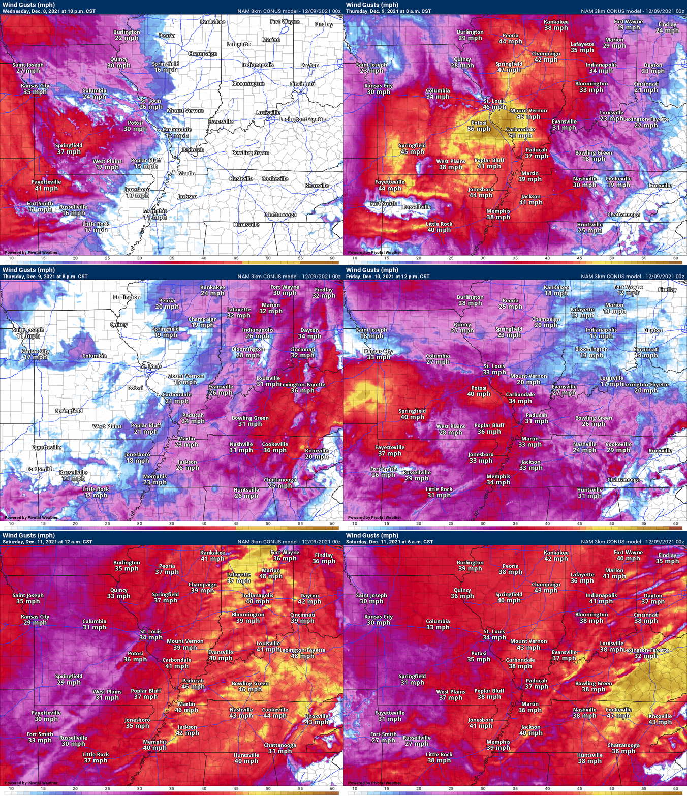
Dry today. Warmline trend. Windy, at times. Winds may gust above 30 mph.
Clouds increase tonight. Some patchy rain showers are possible tonight, as well. We will have a chance of dense fog. Use care if you must travel in areas of dense fog.
The dense fog may linger into Friday morning as that warm front moves northward through the region.
Most of Friday may remain dry.
Gusty winds are likely today into Friday night.
Wind forecast (gusts).
Friday afternoon and Friday night.
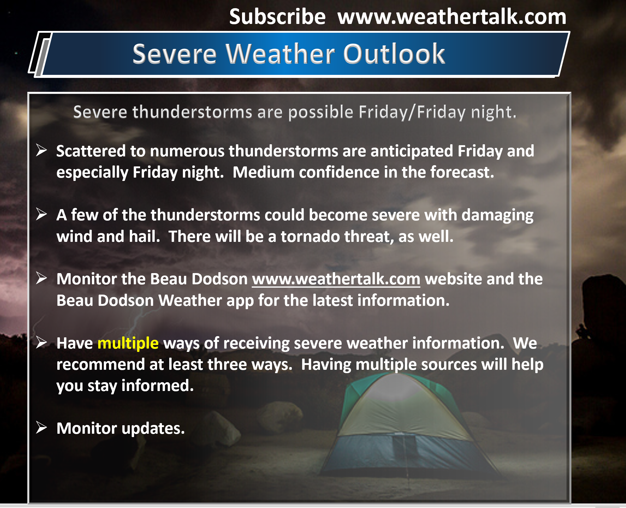
A severe weather event appears likely Friday afternoon and especially Friday night.
Severe weather events are fickle. All ingredients must come together in order for there to be severe thunderstorms. No forecast is a slam dunk and this one is no different.
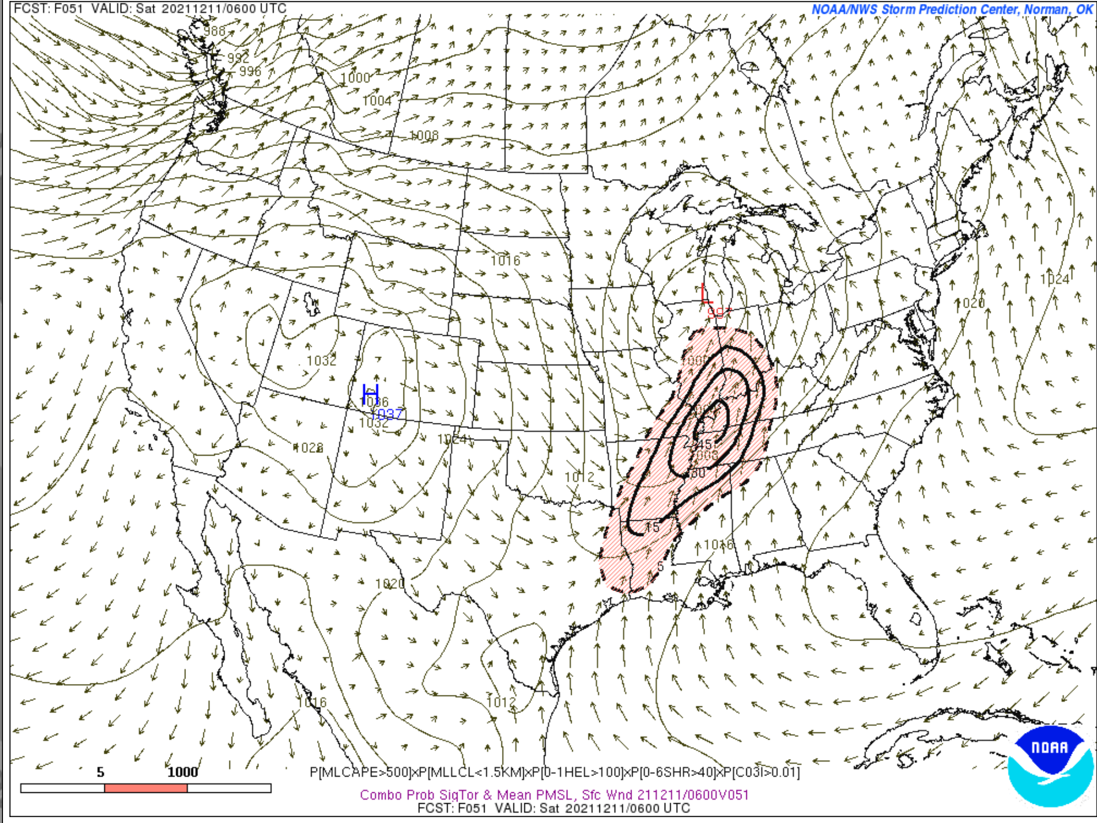
The tornado ingredient forecast has our region in the bulls-eye for the risk. I can’t rule out tornadoes from this event.
It is rare to have tornadoes in December. It is even rarer to have two tornado events in less than a week (in December). Very unusual weather.
.
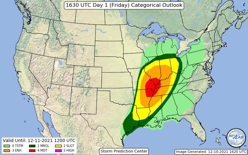
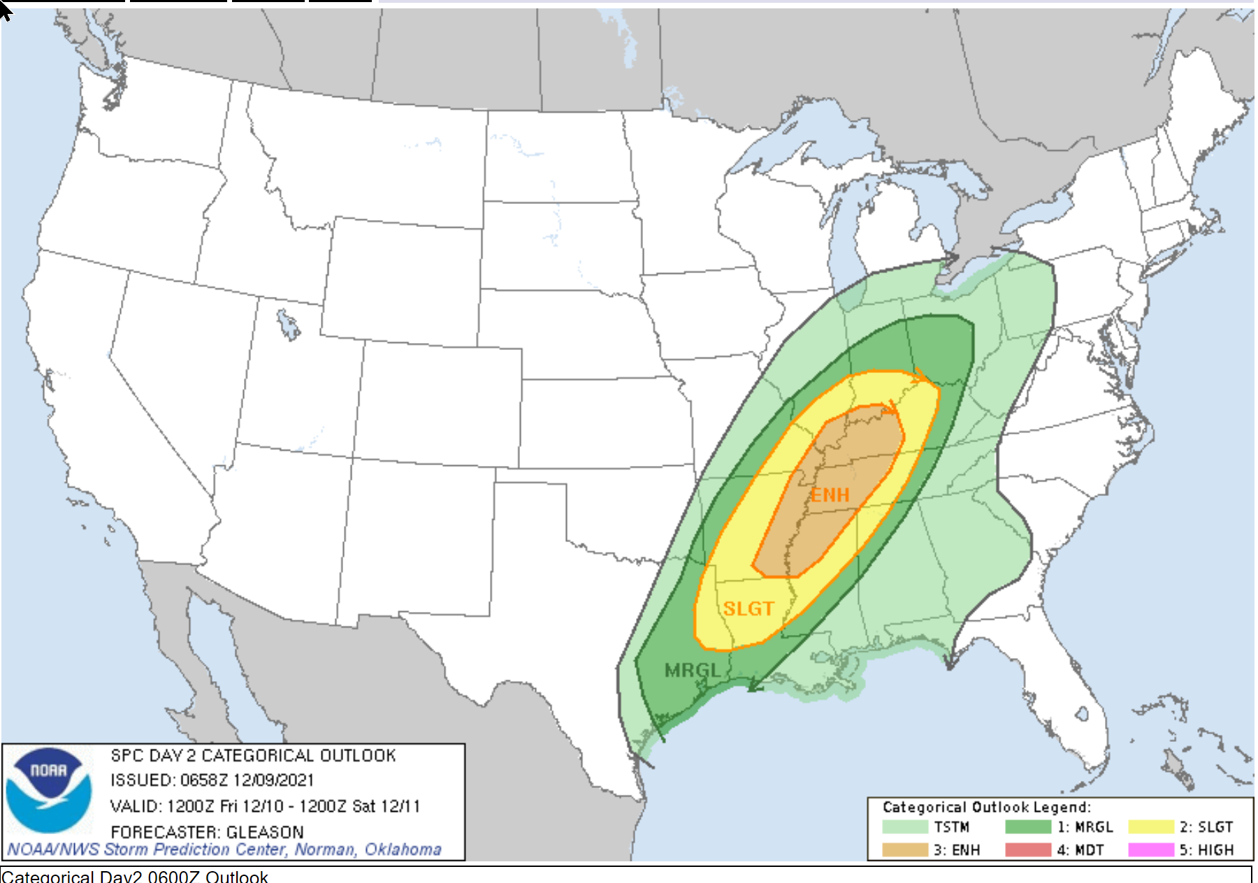
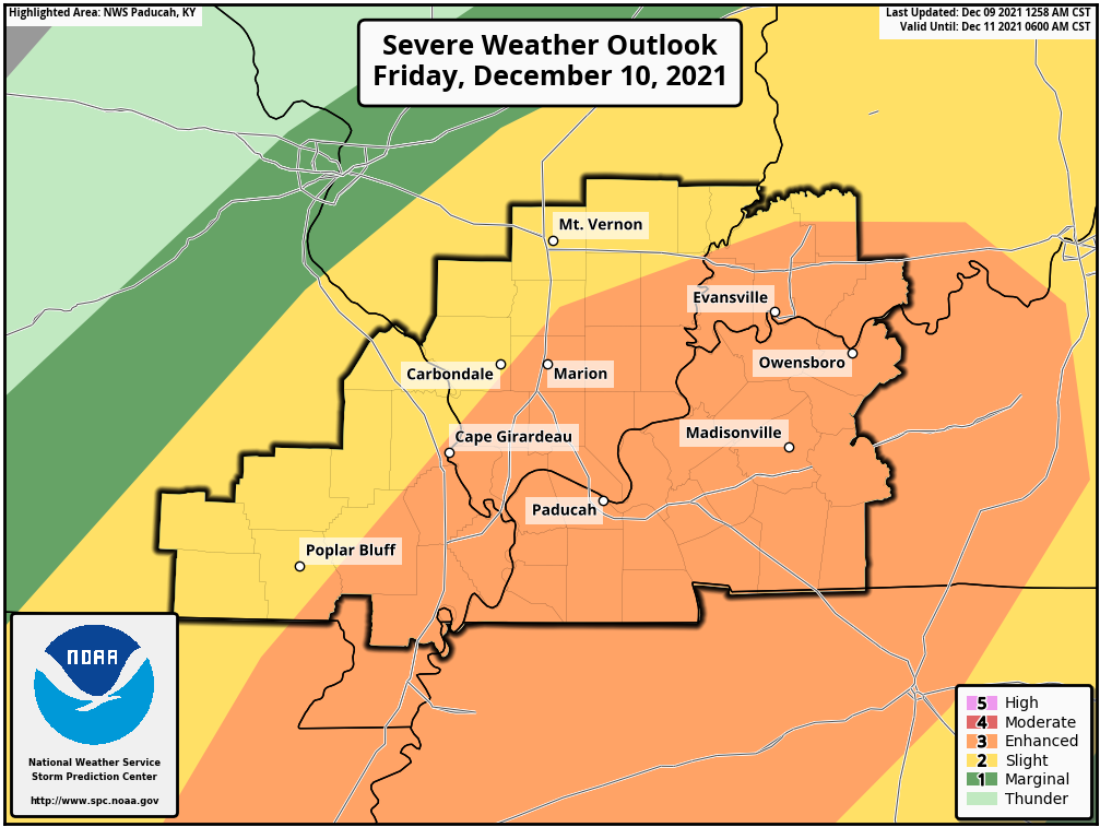
The Storm Prediction Center has our region in an enhanced risk of severe thunderstorms Friday and Friday night. The bulk of this event may be after dark.
The enhanced region is the orange shaded zone. This is a level three out of five risk. Five being the highest risk.
Zooming in on that map. The black outline is the Paducah, Kentucky, NWS forecast area.
Dark green is the level one region. Yellow is the level two region. Orange is the level three region.
.
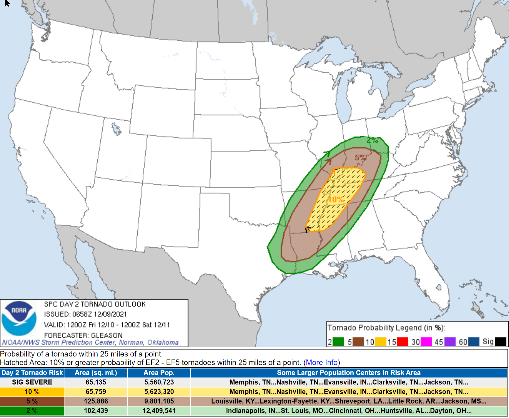
Tornado threat forecast. The hatched zone is where some tornadoes could be EF2 or greater.
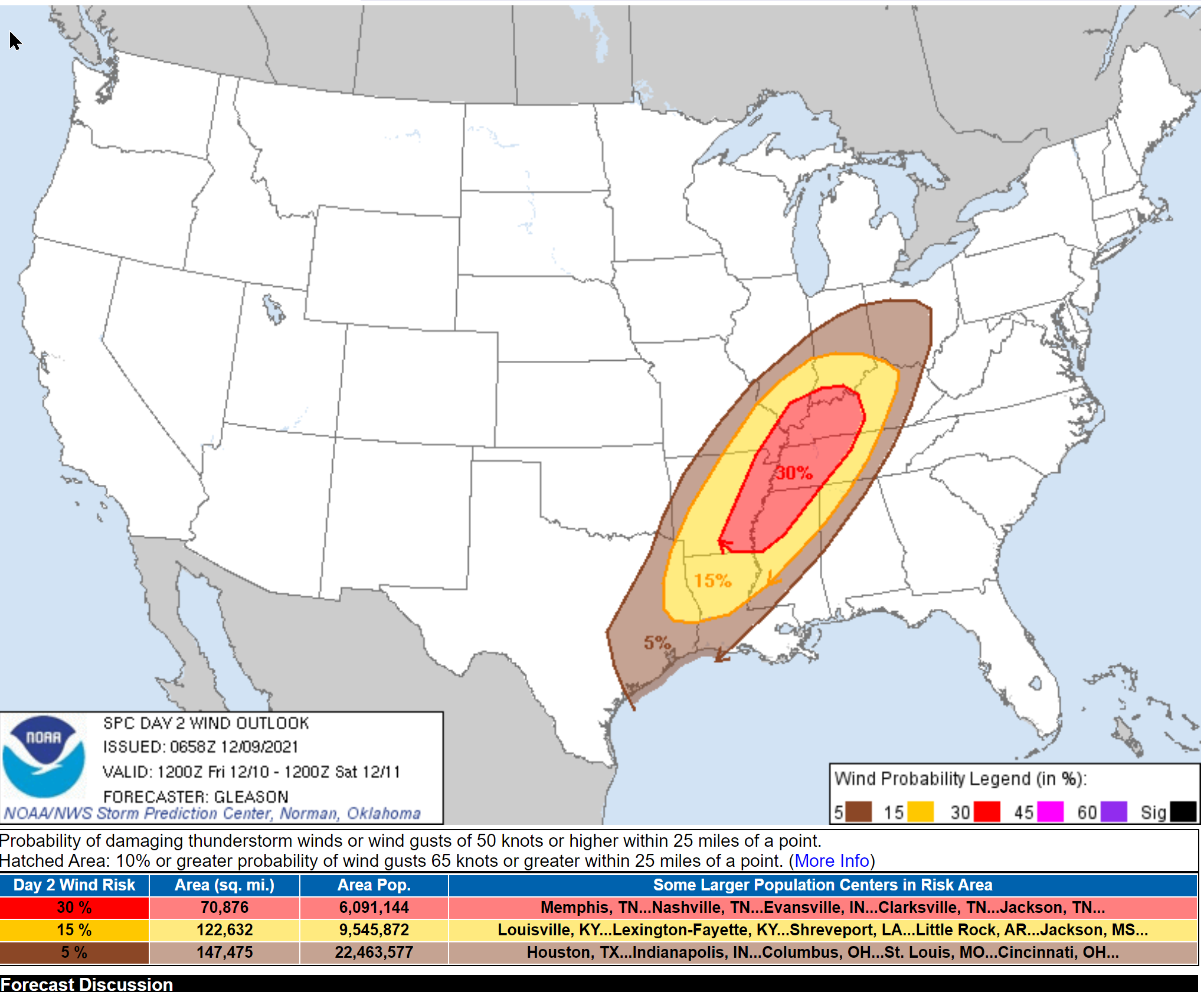
Damaging wind threat zone. A 30% chance of damage wind with 25 miles of any given point.
.
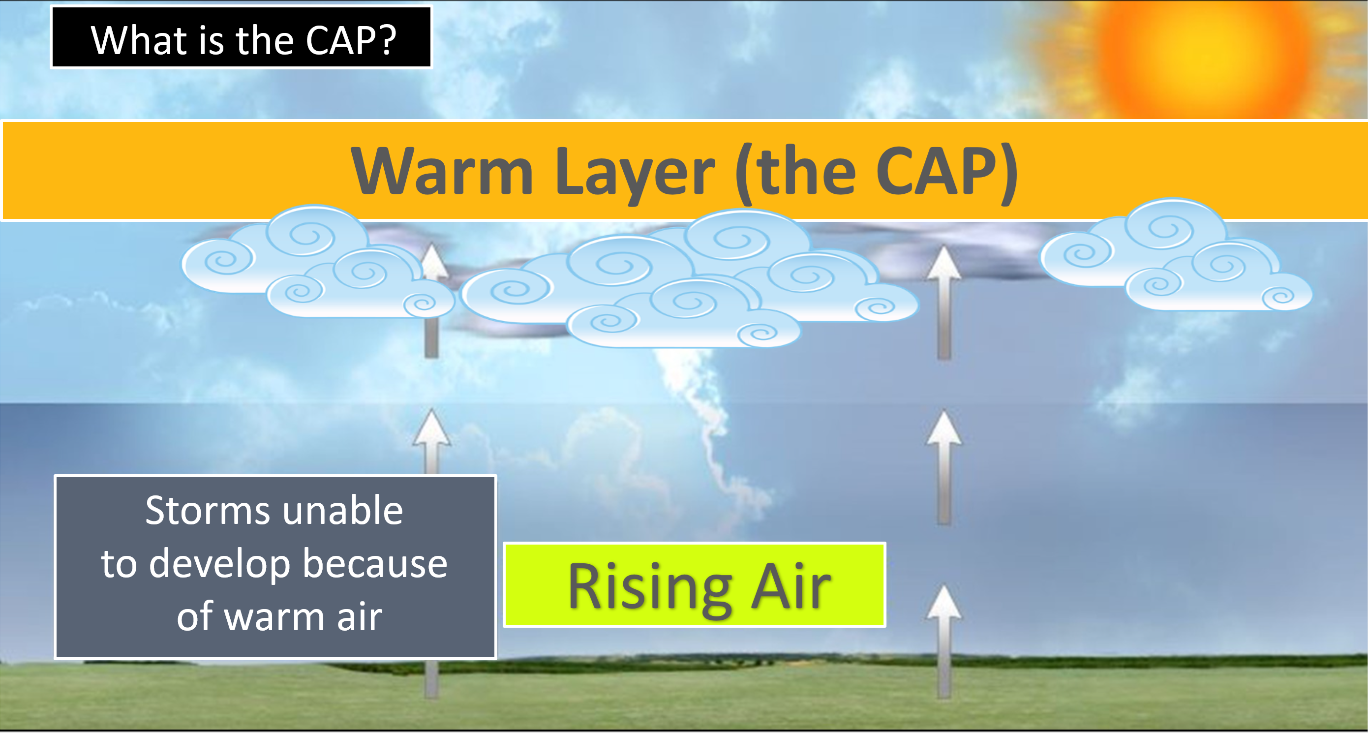
We do have a CAP on the atmosphere. A CAP can keep storms from forming. A CAP is warm air aloft that helps keep air parcels from rising. They rise and hit the CAP and then sink. Thunderstorms are made up of rising thermals. If the thermal can’t rise then severe storms can’t form.
The struggle we are having is timing when the CAP breaks.
.
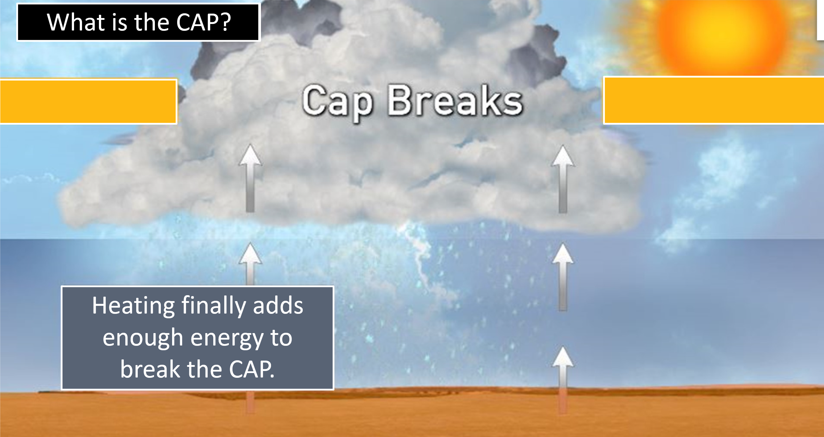
If the CAP breaks then severe thunderstorms will form.
All ingredients are there for damaging wind, large hail, and even tornadoes. Storms may be moving at speeds in excess of 60 mph. That means there will be a short amount of time to seek shelter. Be prepared in case severe weather develops.
There is concern the bulk of this event will occur at night.
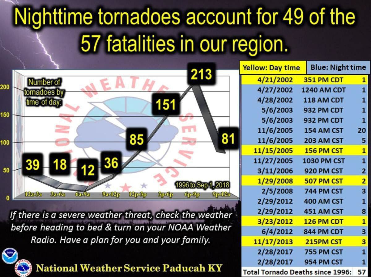
Nighttime tornadoes account for 49 of the 57 fatalities in our region since 1996.
.
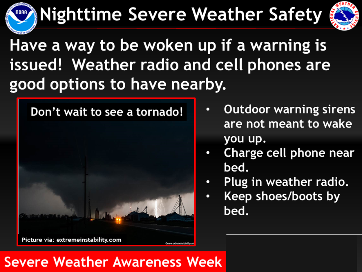
Have multiple ways of receiving severe weather information. Not just my weather app. Have other ways, as well. All technology can fail. Thus, having more than one source can help keep you safe.
.
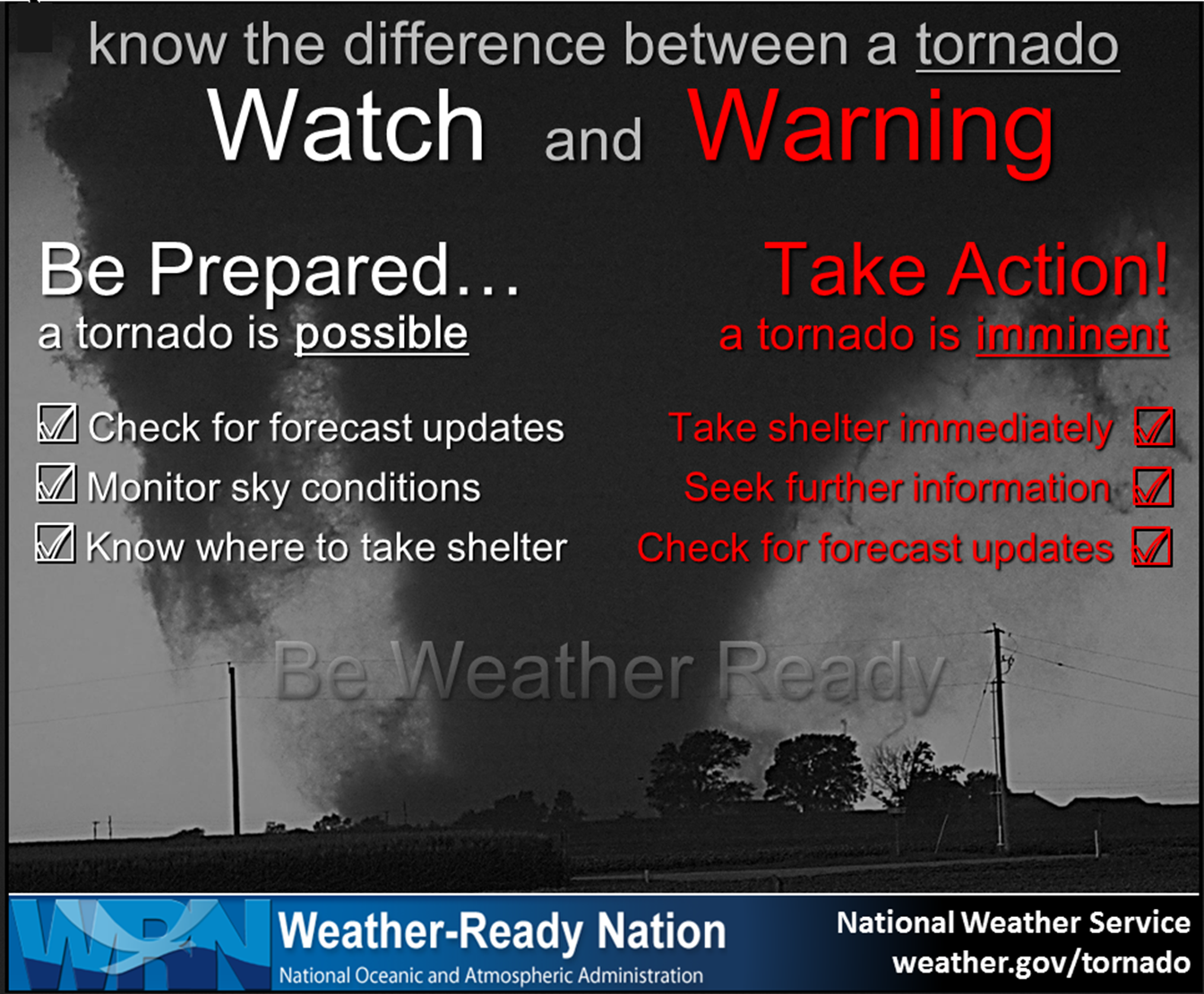
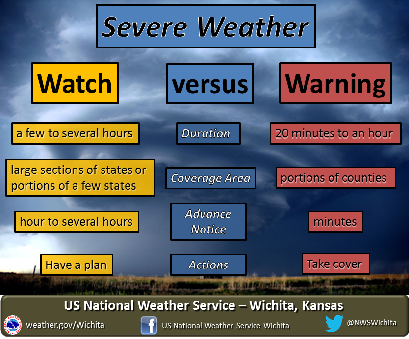
Remember, a WATCH means to monitor updates. You don’t have to change your behavior for a watch. Be prepared.
A WARNING is more serious. A WARNING means severe weather is imminent in or near your location. A WARNING means to seek shelter.
.
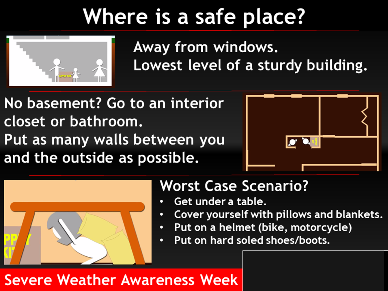
Where is a safe place to hide when tornadoes threaten your location.
.
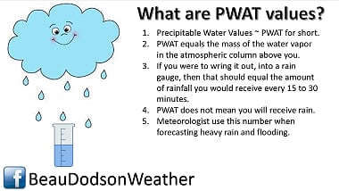
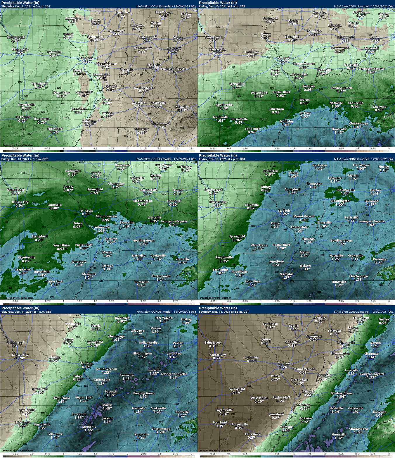
PWAT values will at the top of the chart with this event. That means plenty of moisture to work with. That equals locally heavy rain.
PWAT animation map. Watch the wave of higher PWAT values sweep through our region Friday and Friday night. Lot of moisture.
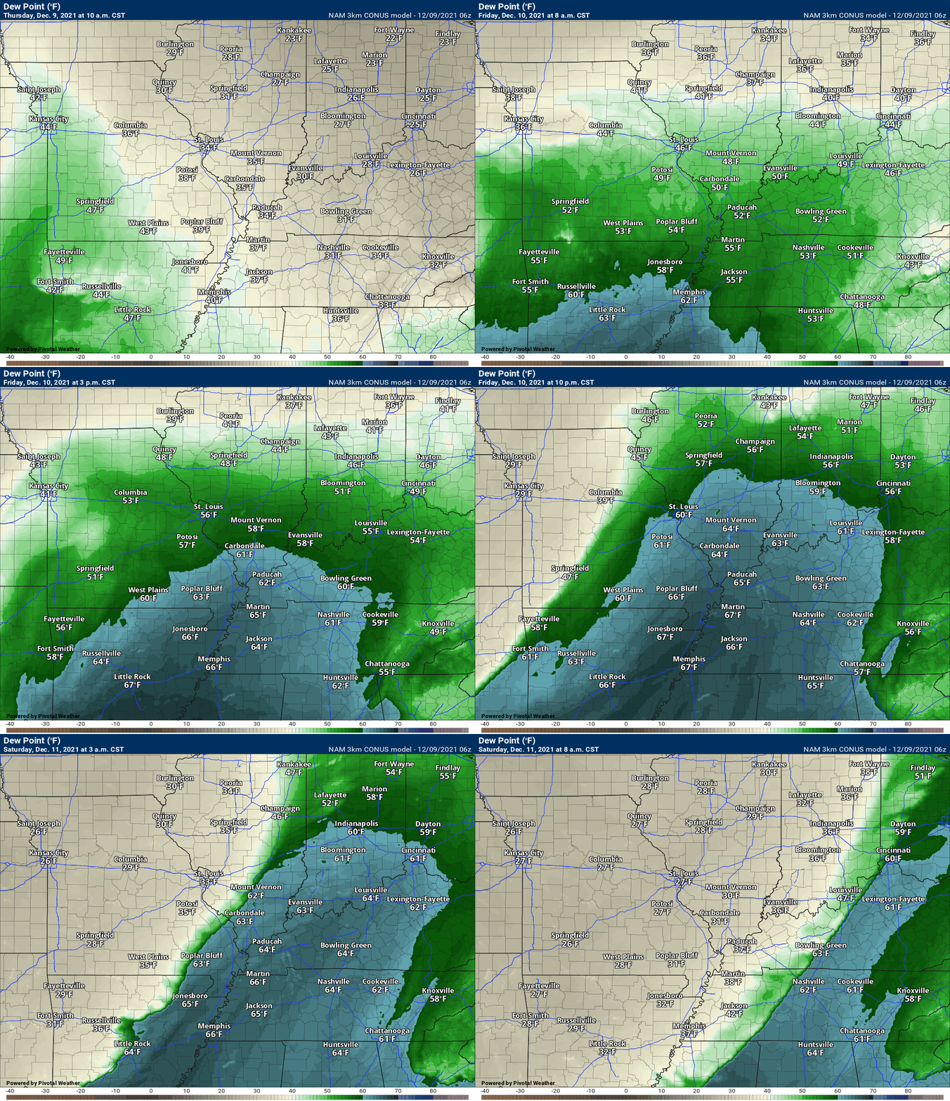
Dew points will be high, as well. This is a concern for severe thunderstorms.
Typically, I look for dew points of 58 degrees and above when considering severe weather. The record high dew point in Paducah is around sixty-six. We may approach that. Again, plenty of moisture for thunderstorms to tap into.
Click animations to enlarge them.
Dew points will rapidly rise Friday/Friday night. Perhaps to near record high December dew points. The record high dew point in Paducah is 66 degrees (for December).
Bottom line:
Severe weather appears likely Friday afternoon and especially Friday night into early Saturday morning. Be weather aware and prepared to seek shelter in the event thunderstorms threaten your location.
.

Click here if you would like to return to the top of the page.
Again, as a reminder, these are models. They are never 100% accurate. Take the general idea from them.
What should I take from these?
- The general idea and not specifics. Models usually do well with the generalities.
- The time-stamp is located in the upper left corner.
- The EC European weather model is in Zulu time.
.
What am I looking at?
You are looking at different models. Meteorologists use many different models to forecast the weather. All models are wrong. Some are more wrong than others. Meteorologists have to make a forecast based on the guidance/models.
I show you these so you can see what the different models are showing as far as precipitation. If most of the models agree, then the confidence in the final weather forecast increases.
You can see my final forecast at the top of the page.
.
This animation is the Storm Prediction Center WRF model.
This animation shows you what radar might look like as the next system pulls through the region. It is a future-cast radar.
Time-stamp upper left. Click the animation to enlarge it.
.
This animation is the HRW short-range model.
This animation shows you what radar might look like as the next system pulls through the region. It is a future-cast radar.
Time-stamp upper left. Click the animation to enlarge it.
.
.This animation is the higher-resolution 3K NAM American Model.
This next animation is the lower-resolution NAM American Model.
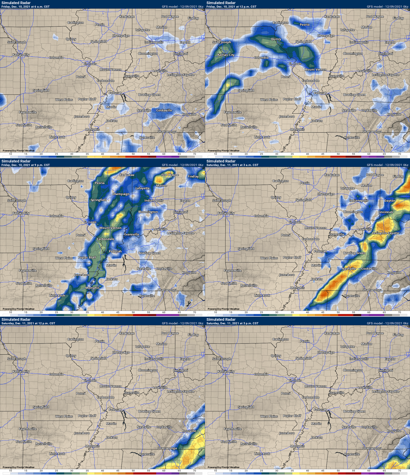
This animation shows you what radar might look like as the system pulls through the region. It is a future-cast radar.
Time-stamp upper left. Click the animation to enlarge it.
.
This next animation is the GFS American Model.
.
![]()
Today’s severe weather outlook from the Storm Prediction Center (below).
Light green is where thunderstorms may occur but should be below severe levels.
Dark green is a level one risk. Yellow is a level two risk. Orange is a level three (enhanced) risk. Red is a level four (moderate) risk. Pink is a level five (high) risk.
One is the lowest risk. Five is the highest risk.
A severe storm is one that produces 58 mph wind or higher, quarter size hail, and/or a tornado.
The tan states are simply a region that SPC outlined on this particular map. Just ignore that.

The black outline is our local area.

.
Tomorrow’s severe weather outlook.

![]()
![]()
Some safety graphics.
.![]()
.
.

Radar Link: Interactive local city-view radars & regional radars.
You will find clickable warning and advisory buttons on the local city-view radars.
If the radar is not updating then try another one. If a radar does not appear to be refreshing then hit Ctrl F5. You may also try restarting your browser.
Not working? Email me at beaudodson@usawx.com
Backup radar site in case the above one is not working.
https://weathertalk.com/morani
New ZOOM radar (with storm chasers)
https://wtalk.co/AVWG7GM7
Regional Radar
https://imagery.weathertalk.com/prx/RadarLoop.mp4
Lightning Data (zoom in and out of your local area)
https://wtalk.co/WJ3SN5UZ
Satellite Data
Computers and tablets. These two satellite links may not work well on cell phones.
Visible Satellite. This one is to be used during daylight only. Be sure and hit refresh once you are on the satellite page. Otherwise, the data will be old.
https://col.st/a5A0e
IR Satellite. This one shows cloud temperatures. Bright colors represent cold cloud tops. That could mean thunderstorms. Be sure and hit refresh once you are on the satellite page. Otherwise, the data will be old.
https://col.st/R2fw1
Water Vapor Satellite. This one shows mid-level moisture in the atmosphere. Be sure and hit refresh once you are on the satellite page. Otherwise, the data will be old.
https://col.st/xFVwx
.

Live lightning data: Click here.
Not receiving app/text messages?
Log in and out of your app.
USE THE APP. ATT and Verizon are slowing or stopping the text messages. Move to the app (not texts).
Make sure you have the correct app/text options turned on. Find those under the personal notification settings tab at www.weathertalk.com. Red is off. Green is on.
Subscribers, PLEASE USE THE APP. ATT and Verizon are not reliable during severe weather. They are delaying text messages.
The app is under WeatherTalk in the app store.
Apple users click here
Android users click here
.


