September 8, 2018
Saturday Forecast Details
Forecast: Showers and thunderstorms continuing across portions of southern Illinois and western Kentucky. New activity may form as we move into the afternoon hours. Locally heavy rain will occur. A few storms could be intense, especially across western Kentucky and Tennessee.
Temperatures: MO ~72 to 80 IL ~ 72 to 79 KY ~ 78 to 84 TN ~ 78 t0 84
What is the chance of precipitation? MO ~ 50% to 60% IL ~ 70% to 80% KY ~ 60% to 70% TN ~ 50% to 60%
Coverage of precipitation: Widespread morning rain. A lull. More showers and storms forming in the afternoon.
Wind: East and southeast at 8 to 14 mph with gusts to 25 mph
What impacts are anticipated from the weather? Wet roadways and scattered lightning. Locally heavy rain could cause flash flooding in a few locations. A few storms could be severe with strong winds and even short-lived tornadoes. Lower confidence on the severe weather portion of the forecast.
My confidence in the forecast verifying: High
Is severe weather expected? Monitor updates. There could be some strong storms.
The NWS defines severe weather as 58 mph wind or great, 1″ hail or larger, and/or tornadoes
Should I cancel my outdoor plans? Have a plan B and monitor radars and updates
UV Index: 2 to 4 Low
Sunrise: 6:32 AM
Saturday Night Forecast Details:
Forecast: Showers and a few thunderstorms. Locally heavy rain again possible.
Temperatures: MO ~ 60 to 65 IL ~ 62 to 64 KY ~ 62 to 64 TN ~ 64 to 68
What is the chance of precipitation? MO ~ 40% to 50% IL ~ 60% KY ~ 70% TN ~ 70%
Coverage of precipitation: Numerous showers and some thunderstorms possible.
Wind: West and northwest at 8 to 14 mph. Gusty winds from time to time.
What impacts are anticipated from the weather? Wet roadways and lightning. Locally heavy rain. I will monitor the risk of severe weather before 8 PM.
My confidence in the forecast verifying: Medium
Is severe weather expected? Monitor updates. There could be some strong storms.
The NWS defines severe weather as 58 mph wind or great, 1″ hail or larger, and/or tornadoes
Should I cancel my outdoor plans? Have a plan B and monitor radars and updates
Moonrise: 5:02 AM Waning Crescent
Moonset: 6:54 PM
September 9, 2018
Sunday Forecast Details
Forecast: Mostly cloudy. Scattered showers. Rain should be ending from west to east.
Temperatures: MO ~ 66 to 72 IL ~ 68 to 72 KY ~ 72 to 76 TN ~ 74 to 76
What is the chance of precipitation? MO ~ 30% IL ~ 30% KY ~ 40% to 50% TN ~ 40% to 50%
Coverage of precipitation: Ending from west to east
Wind: West and northwest at 6 to 12 mph with gusts to 16 mph
What impacts are anticipated from the weather? Scattered wet roadways and lightning. Locally heavy rain could cause flash flooding in a few locations.
My confidence in the forecast verifying: Medium
Is severe weather expected? No
The NWS defines severe weather as 58 mph wind or great, 1″ hail or larger, and/or tornadoes
Should I cancel my outdoor plans? Have a plan B and monitor radars and updates
UV Index: 3 to 6 Low to moderate
Sunrise: 6:32 AM
Sunday Night Forecast Details:
Forecast: Partly cloudy. Some clearing. Patchy fog possible.
Temperatures: MO ~ 54 to 58 IL ~ 54 to 58 KY ~ 56 to 58 TN ~ 58 to 62
What is the chance of precipitation? MO ~ 0% IL ~ 0% KY ~ 10% TN ~ 10%
Coverage of precipitation: Rain will have most likely ended.
Wind: Northwest at 5 to 10 mph
What impacts are anticipated from the weather? Patchy fog possible. This could lower visibility
My confidence in the forecast verifying: High
Is severe weather expected? No
The NWS defines severe weather as 58 mph wind or great, 1″ hail or larger, and/or tornadoes
Should I cancel my outdoor plans? No
Sunset: 7:12 PM
Moonrise: 6:14 AM Waning Crescent
Moonset: 7:32 PM
September 10, 2018
Monday Forecast Details
Forecast: Patchy morning fog. Partly to mostly sunny. Mild.
Temperatures: MO ~ 74 to 78 IL ~ 74 to 78 KY ~ 74 to 78 TN ~ 74 to 78
What is the chance of precipitation? MO ~ 0% IL ~ 0% KY ~ 10% TN ~ 10%
Coverage of precipitation: Most likely none
Wind: North and northwest at 5 to 10 mph
What impacts are anticipated from the weather? Morning fog could lower visibility
My confidence in the forecast verifying: High
Is severe weather expected? No
The NWS defines severe weather as 58 mph wind or great, 1″ hail or larger, and/or tornadoes
Should I cancel my outdoor plans? No
UV Index: 6 to 7 Moderate to high
Sunrise: 6:33 AM
Monday Night Forecast Details:
Forecast: A few clouds. Cool. Patchy fog.
Temperatures: MO ~ 58 to 62 IL ~ 58 to 62 KY ~ 58 to 62 TN ~ 58 to 62
What is the chance of precipitation? MO ~ 0% IL ~ 0% KY ~ 0% TN ~ 0%
Coverage of precipitation: Most likely none
Wind: North and northeast at 5 to 10 mph
What impacts are anticipated from the weather? Patchy fog could lower visibility.
My confidence in the forecast verifying: High
Is severe weather expected? No
The NWS defines severe weather as 58 mph wind or great, 1″ hail or larger, and/or tornadoes
Should I cancel my outdoor plans? N0
Sunset: 7:10 PM
Moonrise: 7:24 AM New
Moonset: 8:09 PM
September 11, 2018
Tuesday Forecast Details
Forecast: Mostly sunny. A few clouds from time to time. Pleasant temperatures.
Temperatures: MO ~ 76 to 78 IL ~ 76 to 78 KY ~ 76 to 78 TN ~ 76 to 82
What is the chance of precipitation? MO ~ 0% IL ~ 0% KY ~ 0% TN ~ 0%
Coverage of precipitation: Most likely none.
Wind: North and northeast at 5 to 10 mph
What impacts are anticipated from the weather? Most likely none.
My confidence in the forecast verifying: Medium
Is severe weather expected? No
The NWS defines severe weather as 58 mph wind or great, 1″ hail or larger, and/or tornadoes
Should I cancel my outdoor plans? No
UV Index: 6 to 7 Moderate to high
Sunrise: 6:34 AM
Tuesday Night Forecast Details:
Forecast: Partly cloudy.
Temperatures: MO ~ 58 to 64 IL ~ 60 to 64 KY ~ 60 to 64 TN ~ 62 to 64
What is the chance of precipitation? MO ~ 0% IL ~ 0% KY ~ 0% TN ~ 0%
Coverage of precipitation: Most likely none. I will be monitoring a weak system near the area.
Wind: Northeast and east at 5 to 10 mph
What impacts are anticipated from the weather? Most likely none.
My confidence in the forecast verifying: Medium
Is severe weather expected? No
The NWS defines severe weather as 58 mph wind or great, 1″ hail or larger, and/or tornadoes
Should I cancel my outdoor plans? No
Sunset: 7:09 PM
Moonrise: 6:34 AM Waxing Crescent
Moonset: 8:43 PM

We offer interactive local city live radars and regional radars.
If a radar does not update then try another one. If a radar does not appear to be refreshing then hit Ctrl F5 on your keyboard.
You may also try restarting your browser. The local city view radars also have clickable warnings.
During the winter months, you can track snow and ice by clicking the winterize button on the local city view interactive radars.

Questions? Broken links? Other questions?
You may email me at beaudodson@usawx.com
The National Weather Service defines a severe thunderstorm as one that produces quarter size hail or larger, 58 mph winds or greater, and/or a tornado.
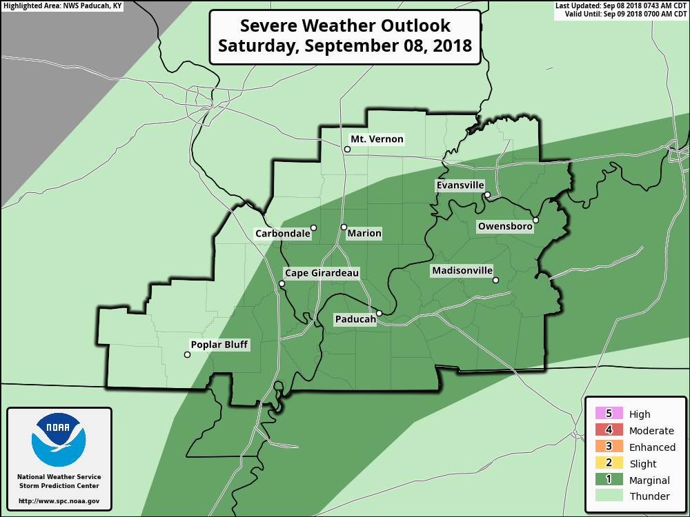
Today: A few storms could be intense this afternoon. The main concern would be damaging wind gusts and short-lived tornadoes. Confidence in severe weather developing is low. Monitor updates.
The Storm Prediction Center has placed us in a marginal (level one out of five risk). One is the lowest risk.
The black outline is simply the Paducah, Kentucky, National Weather Service forecast area.
The light green is where thunderstorms will be possible, but likely not severe.
The dark green is where a few severe thunderstorms could form.
Monitor updates. Confidence in the severe weather portion of the forecast is rather low.
Interactive live weather radar page. Choose the city nearest your location. If one of the cities does not work then try a nearby one. Click here.
National map of weather watches and warnings. Click here.
Storm Prediction Center. Click here.
Weather Prediction Center. Click here.

Live lightning data: Click here.

Interactive GOES R satellite. Track clouds. Click here.

Here are the latest local river stage forecast numbers Click Here.
Here are the latest lake stage forecast numbers for Kentucky Lake and Lake Barkley Click Here.

- Flash flooding last night and this morning.
- Additional rain possible today into Sunday morning.
Good morning, everyone.
Heavy rain fell over the last 24 to 48 hours across much of the region. There were some areas, however, that missed out.
I received nearly three inches of rain at my place in Massac County since Thursday.
Portions of northwest Tennessee and portions of western Kentucky very little (if any) measurable rainfall. The forecast was for the possibility of lesser totals across that region.
We are not finished with the rain chances, yet. So, if you missed out on the overnight rains, then you may still receive some between now and Sunday morning. I know some of you need rain.
Much of the region picked up one to four inches of rain. There were pockets of four to six-inch rain totals. I did have some reports greater than six inches (since Thursday).
Numerous counties were under flash flood warnings overnight. Avoid flooded roadways.
A few counties are still under flash flood warnings. Don’t forget you can click the warnings on the local city-view interactive radars. See link further down in this post. Make sure you activate the watch/warning/advisory button. That will turn on the clickable warnings.
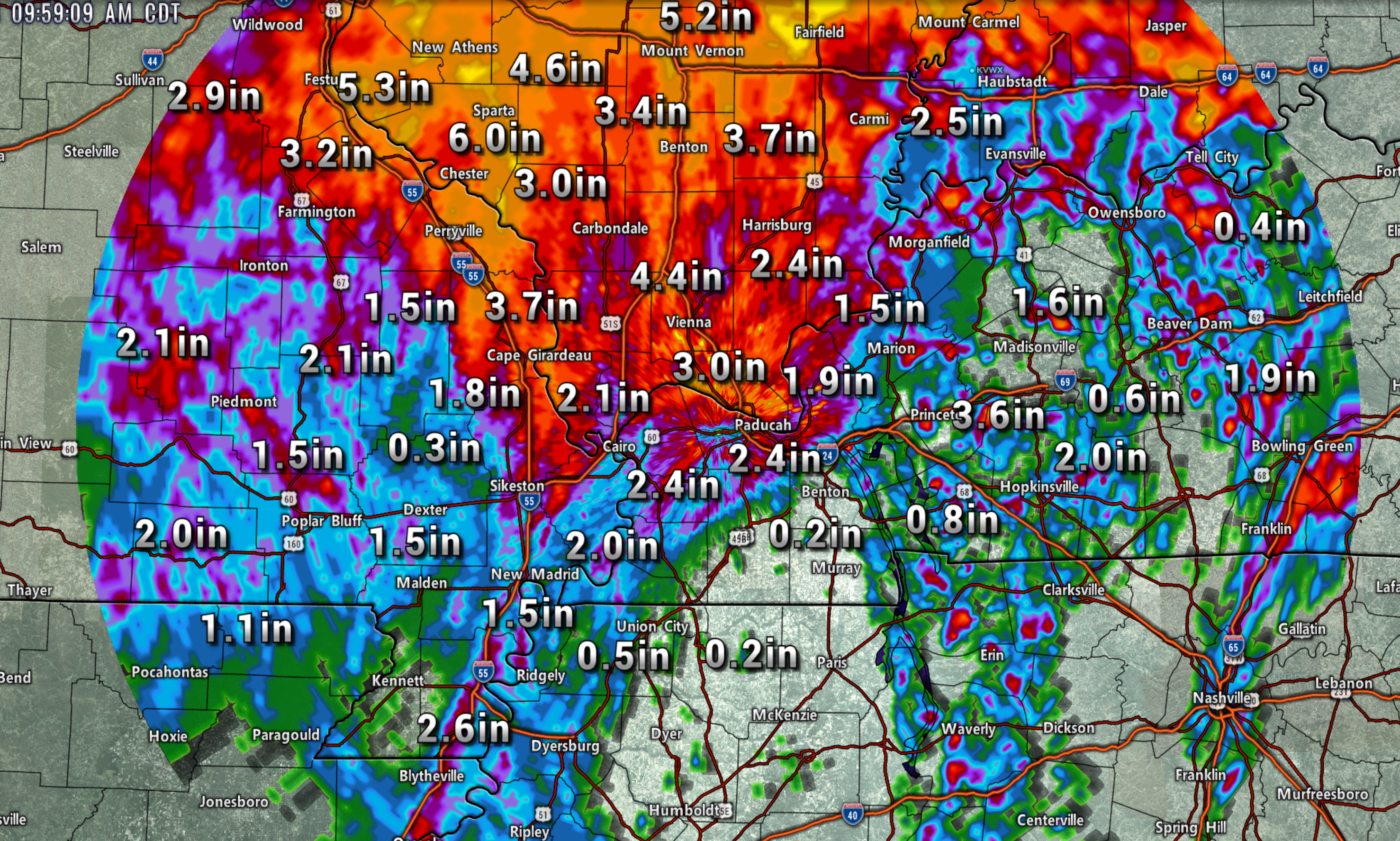
Radar estimated rain totals since yesterday morning (this does not include what fell Thursday night).
Keep in mind, this is what radar estimates. Radar is not perfect. It does, however, give you an idea.
Notice the patchy heavy totals in Kentucky. There was a line of heavy storms that formed Friday afternoon across portions of the Pennyrilel. That helped their totals.
Click to enlarge.
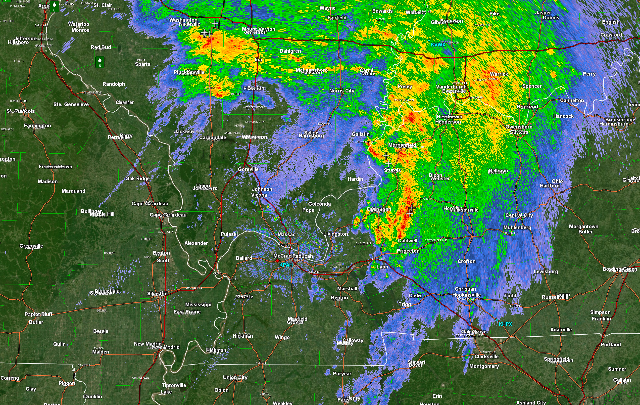
It is still raining in many areas.
Here is the 10:30 AM radar scan. You can see that widespread rain continues across a decent chunk of the region.
See the interactive city-view radars for the latest radar.
We offer interactive local city live radars and regional radars. If a radar does not update then try another one. If a radar does not appear to be refreshing then hit Ctrl F5. You may also try restarting your browser.
The local city view radars also have clickable warnings.
The next question is what happens this afternoon into Sunday morning?
I do expect additional shower and thunderstorm development to occur. Some of the storms will produce heavy rain and gusty winds. There are some questions surrounding coverage. I am not overly confident on how much more rain develops.
Most of the model guidance does show development.
There is some instability today and wind shear. A few thunderstorms could produce damaging wind gusts. I can’t completely rule out short-lived tornadoes. This will be highly dependent on whether a few of the storms end up a bit more isolated. Any bows in the thunderstorm activity would also be a concern. Bowing means to push forward.
I will be sending out app/text messages if severe weather develops. Make sure you have WeatherOne turned on. That is the first app/text message option in your www.weathertalk.com account. Check under the Personal Notification Settings tab. Green is on.
The best chance of a few severe thunderstorms will be western Kentucky and Tennessee. Lesser chances, elsewhere.
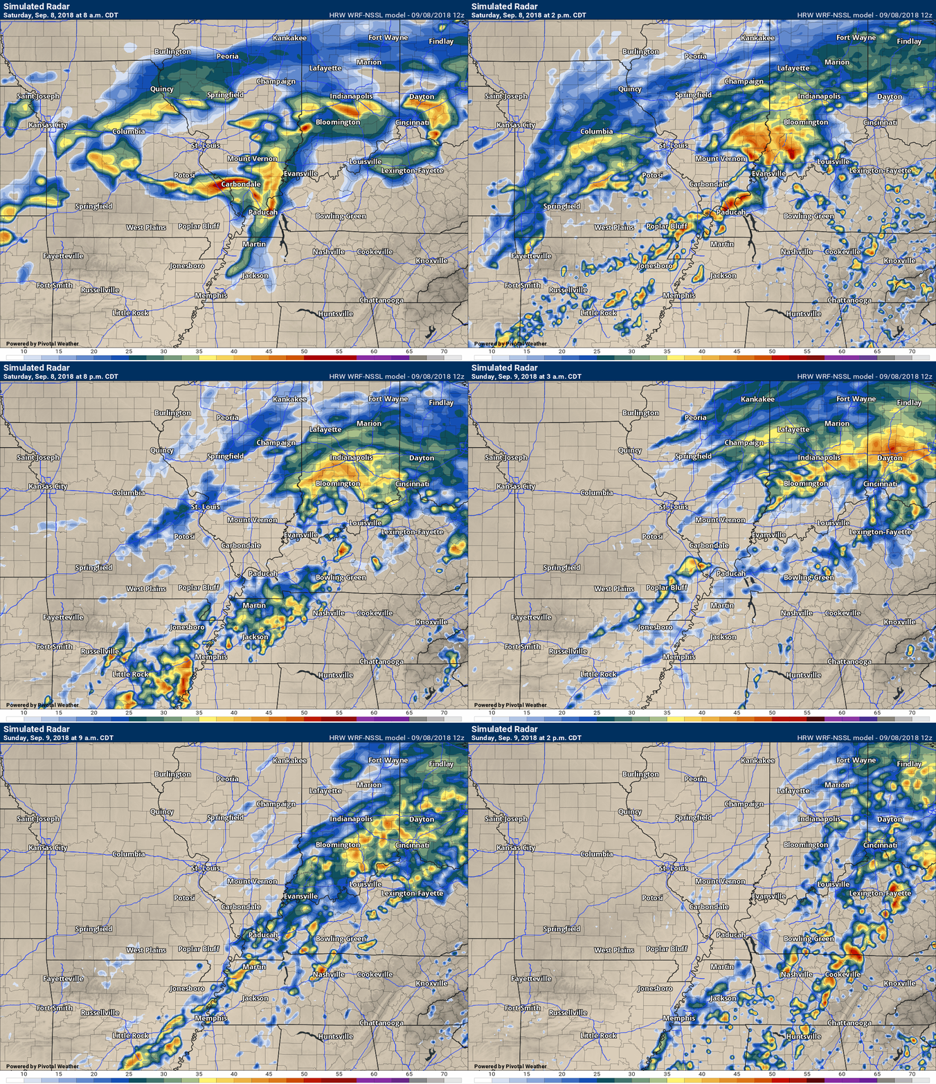
Here is the SPC WRF model guidance future-cast radar. What radar might look like over the coming hours.
The time-stamp is located in the upper left portion of the animation.
Click the animation to enlarge.
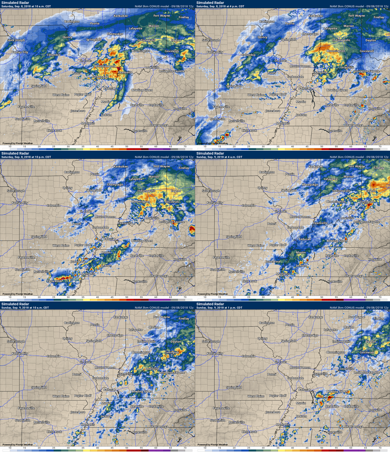
Here is the NAM 3K model (another model).
Rain showers may continue into Sunday morning. Rain will end west to east late tonight/Sunday morning.
Highs over the coming days will mostly be in the 70’s. Decent for this time of the year. Overnight lows may dip into the upper 50’s and lower 60’s. The coolest nights will be Sunday and Monday night.
Temperatures will begin to rebound towards the middle and end of the week. Expect a return to the 80’s.
Monday through Wednesday appears dry.
A weak system brushes the area Thursday. Right now, widespread rain seems unlikely. I will monitor trends.

We offer interactive local city live radars and regional radars. If a radar does not update then try another one. If a radar does not appear to be refreshing then hit Ctrl F5. You may also try restarting your browser.
The local city view radars also have clickable warnings.
During the winter months, you can track snow and ice by clicking the winterize button on the local city view interactive radars.
You may email me at beaudodson@usawx.com
Find me on Facebook!
Find me on Twitter!
Did you know that a portion of your monthly subscription helps support local charity projects?
You can learn more about those projects by visiting the Shadow Angel Foundation website and the Beau Dodson News website.
I encourage subscribers to use the app vs regular text messaging. We have found text messaging to be delayed during severe weather. The app typically will receive the messages instantly. I recommend people have three to four methods of receiving their severe weather information.
Remember, my app and text alerts are hand typed and not computer generated. You are being given personal attention during significant weather events.


