

.
I have some question-and-answer threads over on the Facebook page. Link to those threads CLICK HERE
Or email me at beaudodsonweather@gmail.com
..

🌪️ Seven-Day Tornado Outlook ⛈️
October 21st through October 28th
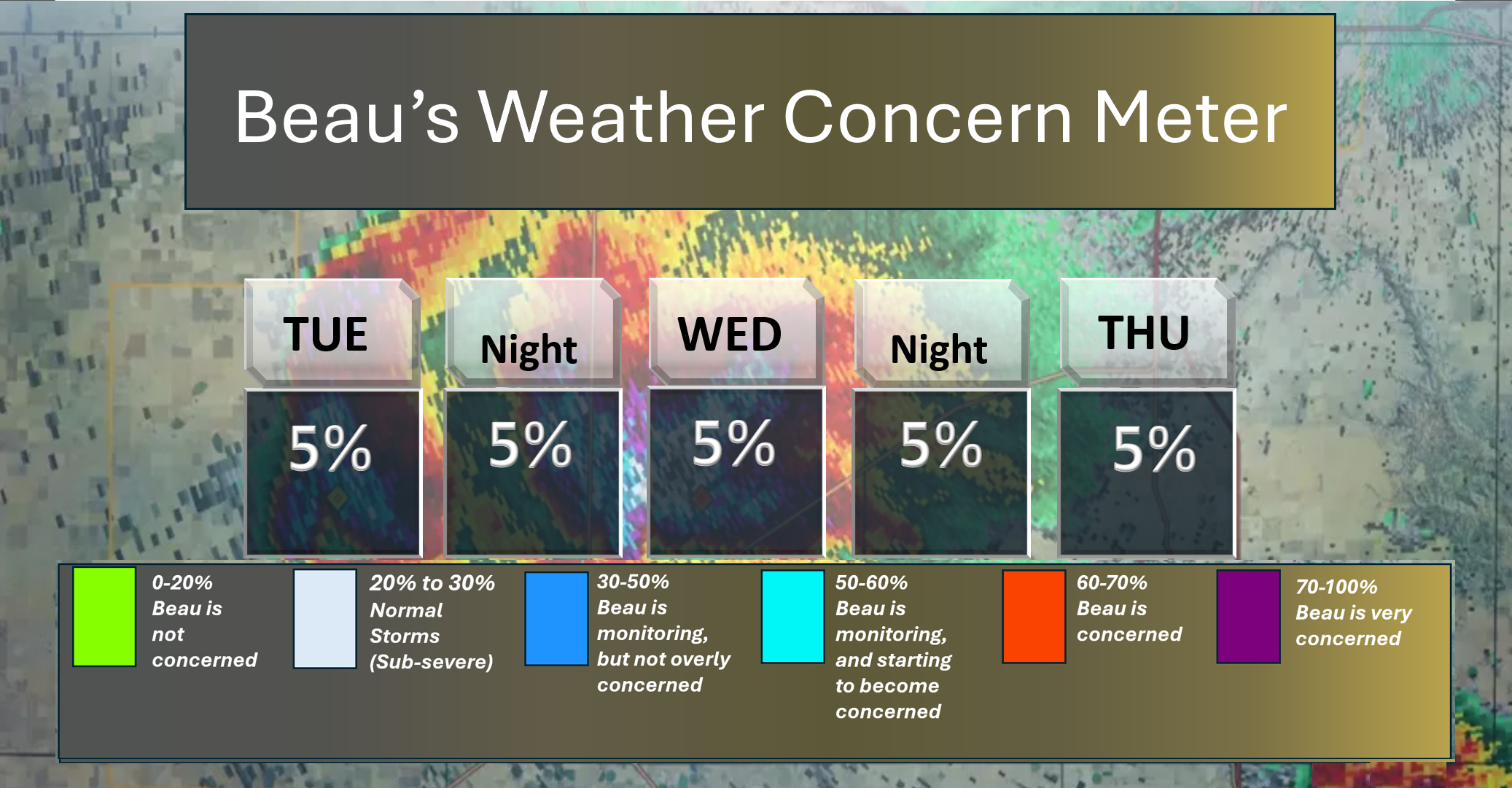
Current risk: None
Current confidence level: High confidence.
Comments: I will keep an eye on next Monday/Tuesday.
.

Seven-Day Hazardous Weather Outlook
1. Is lightning in the forecast? POSSIBLE. I am monitoring Saturday, Sunday, and Monday.
2. Are organized/widespread severe thunderstorms in the forecast? NOT AT THIS TIME. I will monitor early next week.
4. Will non-thunderstorm winds top 40 mph? UNLIKELY. Gusty winds are likely today. They should remain below 40 mph. An occasional gust over southern Illinois and southeast Missouri could approach 40 mph.
5. Will temperatures rise above 90 degrees? NO.
6. Will the temperature fall below 32 degrees? NO.
7. Is a killing frost in the forecast? NO.
8. Is accumulating snow or ice in the forecast? NO.
.
Here is the short-range concern meter.
.
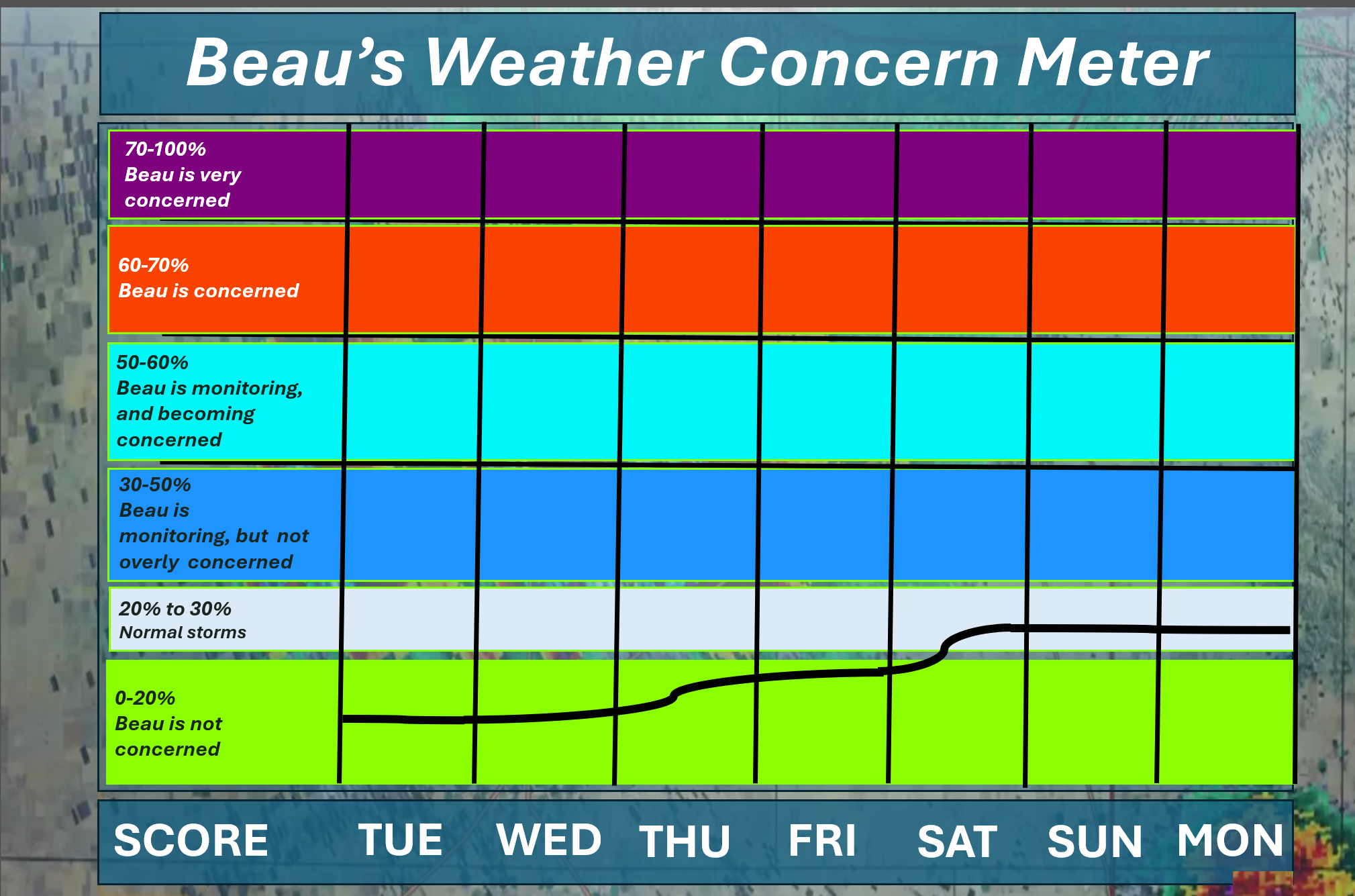
Here is the extended concern meter. This takes us through next Monday.
I will monitor Saturday into Monday for lightning.
.
A quick forecast glance. Your 48-hour forecast Graphics


.
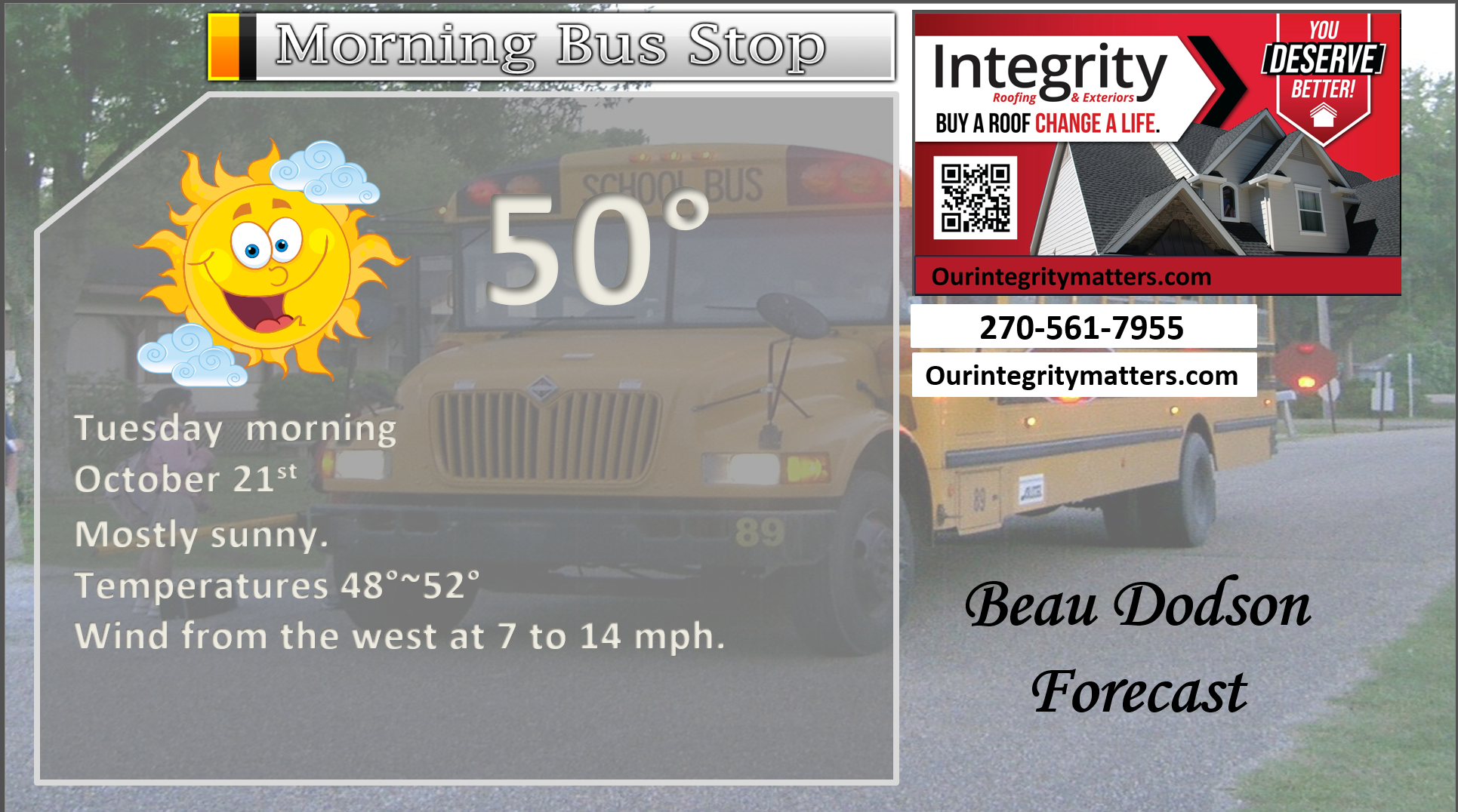
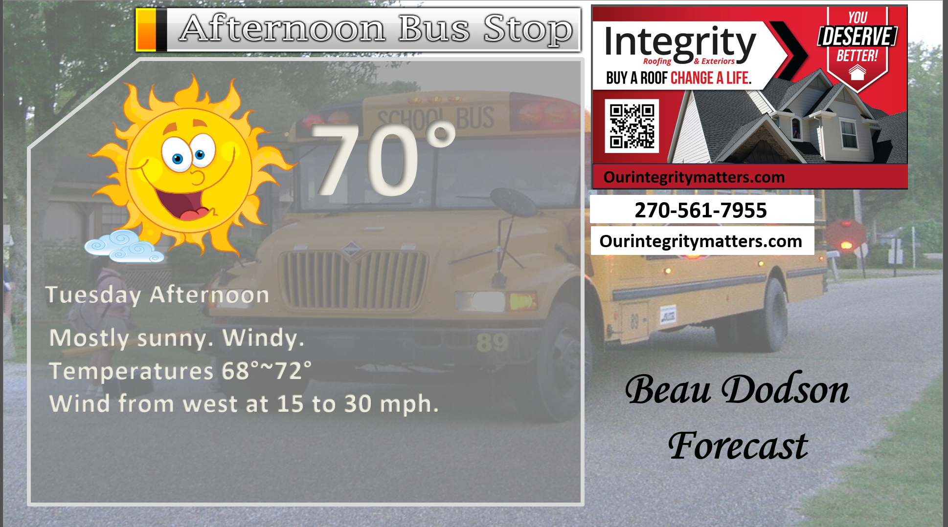
Here is your bus stop forecast.
.
This afternoon
.


Forecast discussion
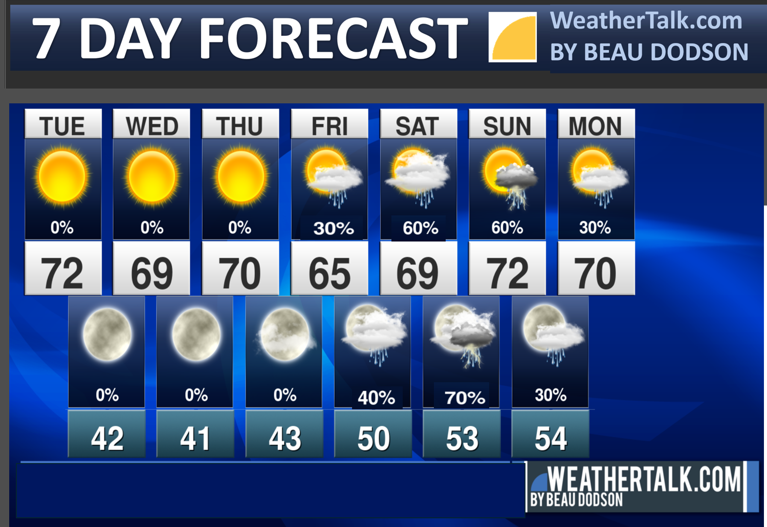
- Cooler temperatures this week.
- Light frost can’t be ruled out on Thursday morning.
- Monitoring rain chances on Friday, Saturday, and Sunday.
- Monitoring another system next Monday and Tuesday.
.
 .
.
.
Seven-day outlook graphic.
.
Good morning, everyone.
It will be calm today through Thursday.
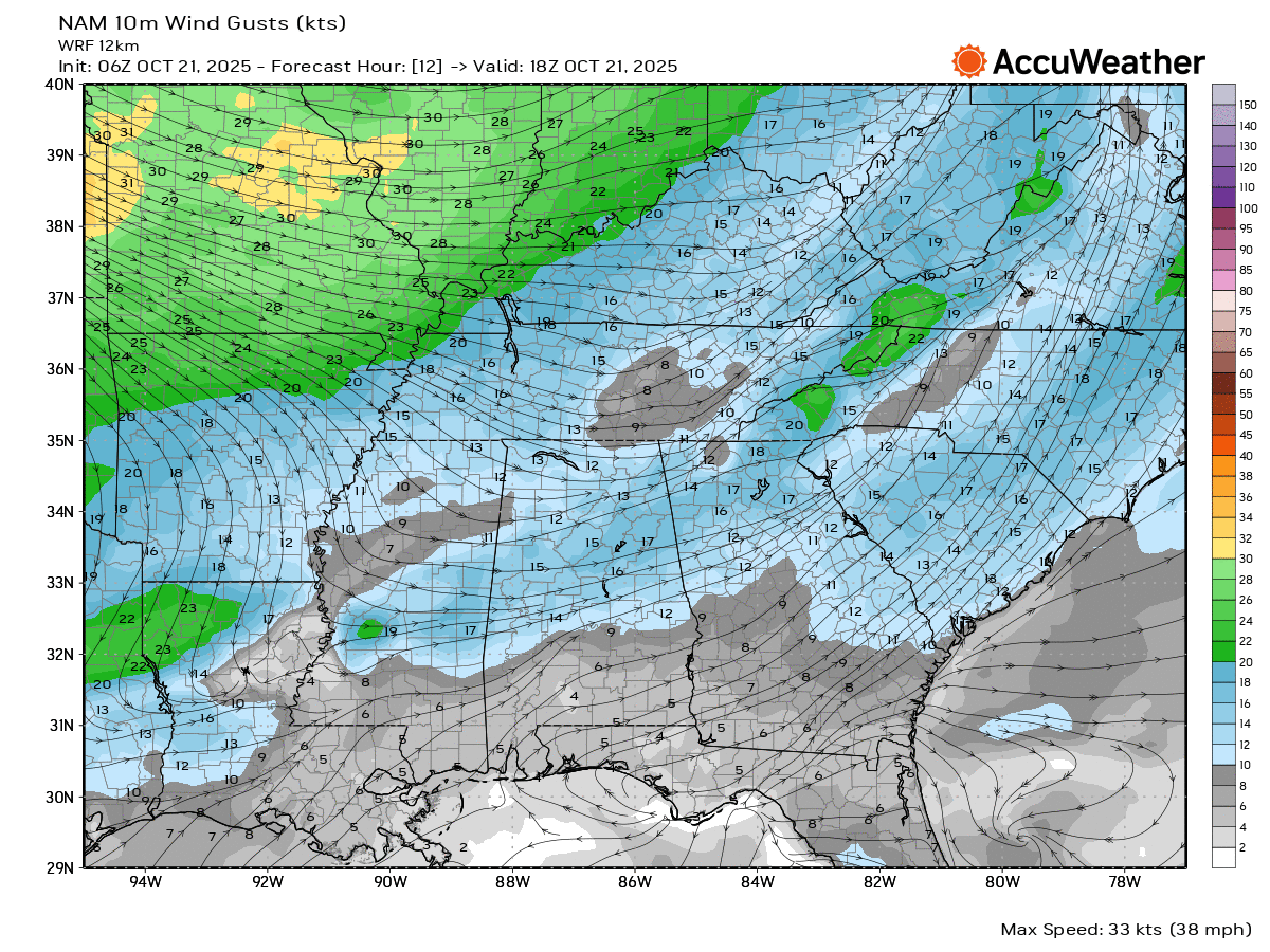
We will have gusty autumn winds again today. Winds may gust above 30 mph from time to time. That might mess with some Halloween decorations.
There is a heightened fire risk today, as well. That is because of the gusty winds combined with low humidity levels. Avoid burning brush and fields.
Here are this afternoon’s wind gusts.
This first graphic is for 1 PM. Peak winds will be late morning into the afternoon hours.
Double-click the image to enlarge it.
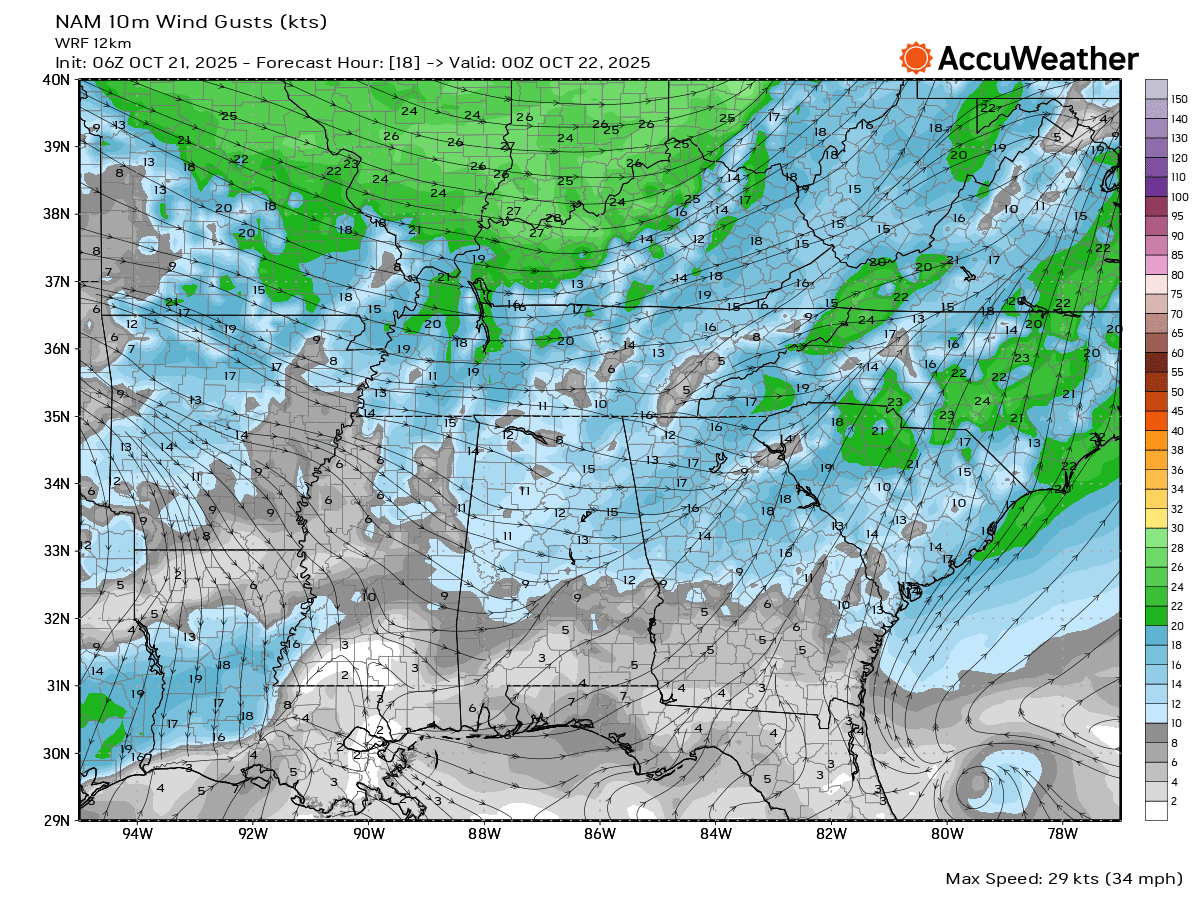
Here is what 7 PM looks like.
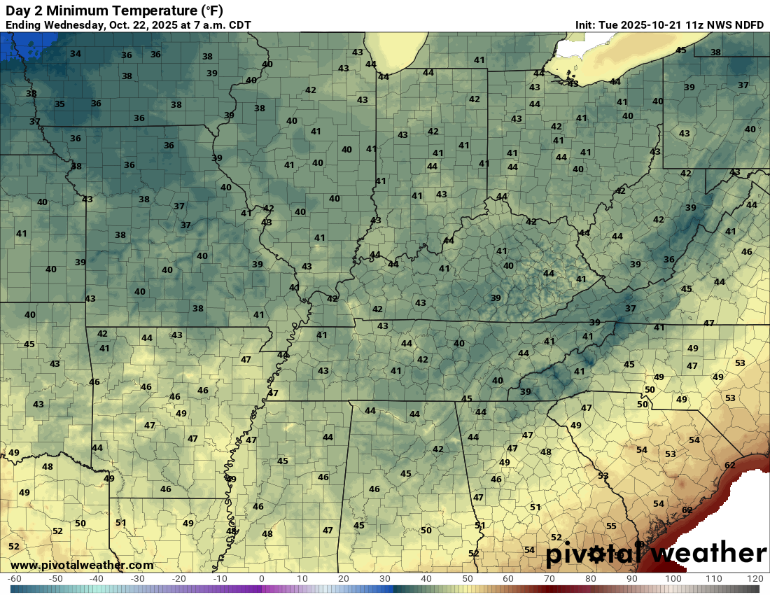
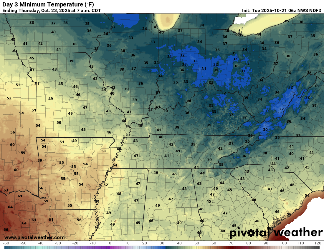
We will have some chilly mornings over the coming days.
The coolest mornings will likely be on Wednesday and Thursday.
Here are the Wednesday morning low temperatures. A few spots could dip into the upper 30s, as well.
Double-click on the image to enlarge it.
.
Thursday morning lows. Areas that tend to be a bit colder could dip into the 30s.
I can’t rule out patchy frost (esp on Thursday morning). Notice temperatures are a little bit warmer over southeast Missouri and the Bootheel. A bit colder over my east northeastern counties.
.
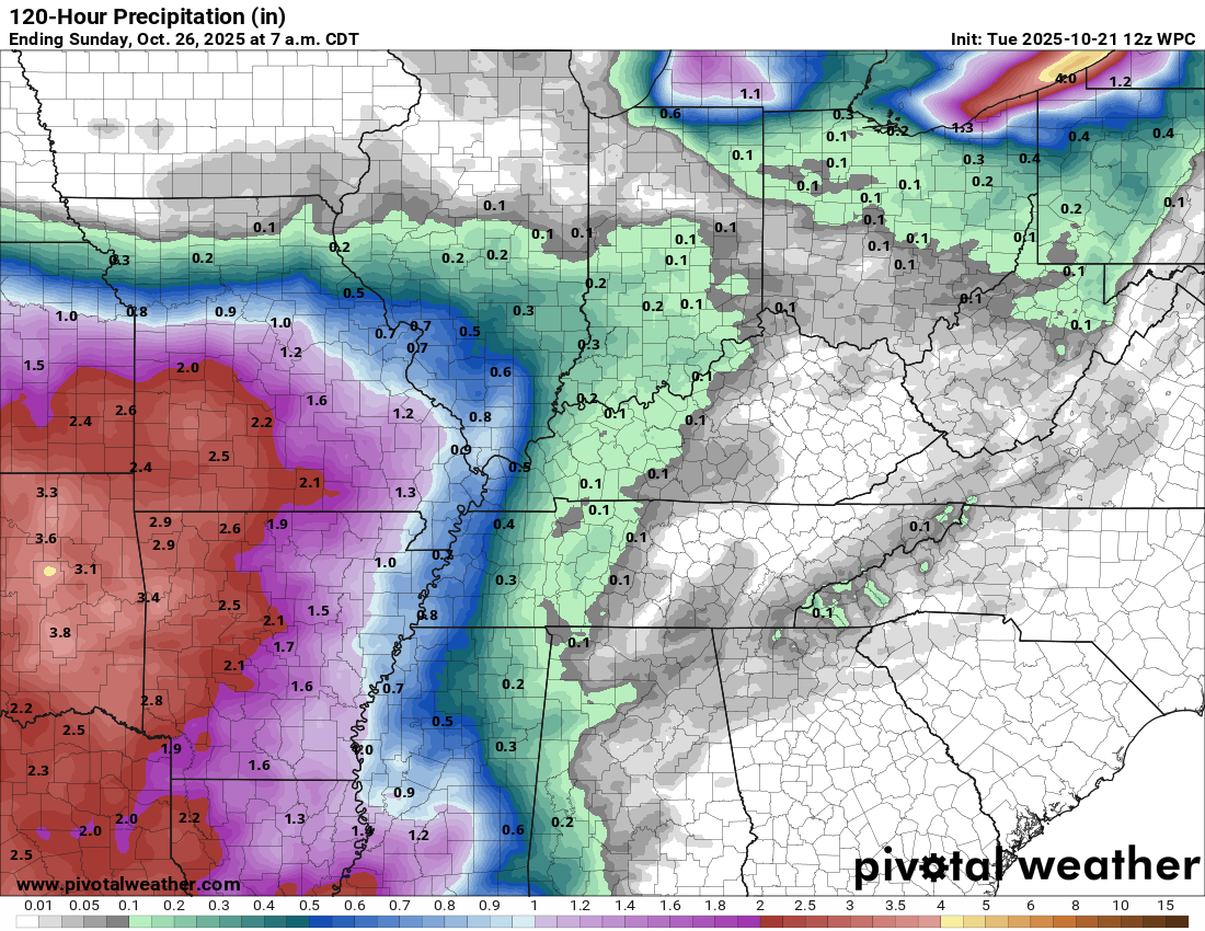
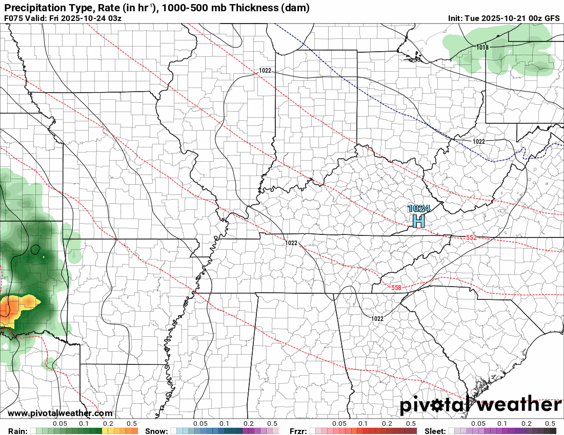
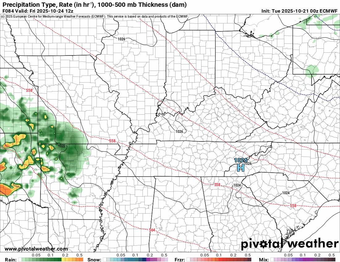
I am monitoring rain chances late Friday into Tuesday.
For now, peak chances appear to be late Saturday into Sunday. Then, another system next Monday and Tuesday.
At this time, this is how the rain totals are shaping up. This is for the first event (Friday to Sunday). This does not include the second event on Monday/Tuesday.
There is quite a bit of disagreement in the data concerning rain totals.
The GFS is a bit heavier. The EC data is a bit lower. I will need to monitor trends.
This event is still a few days away. Adjustments are likely.
.
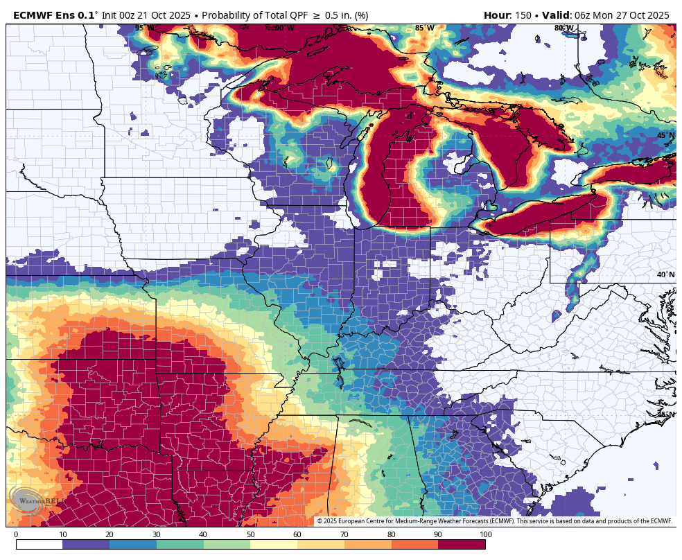
Let me show you the ensembles.
What are the probabilities of 0.50″ or greater of rain falling from Friday to Sunday?
Notice the chances are higher as you travel west-southwest.
EC ensembles
.
GFS model ensembles
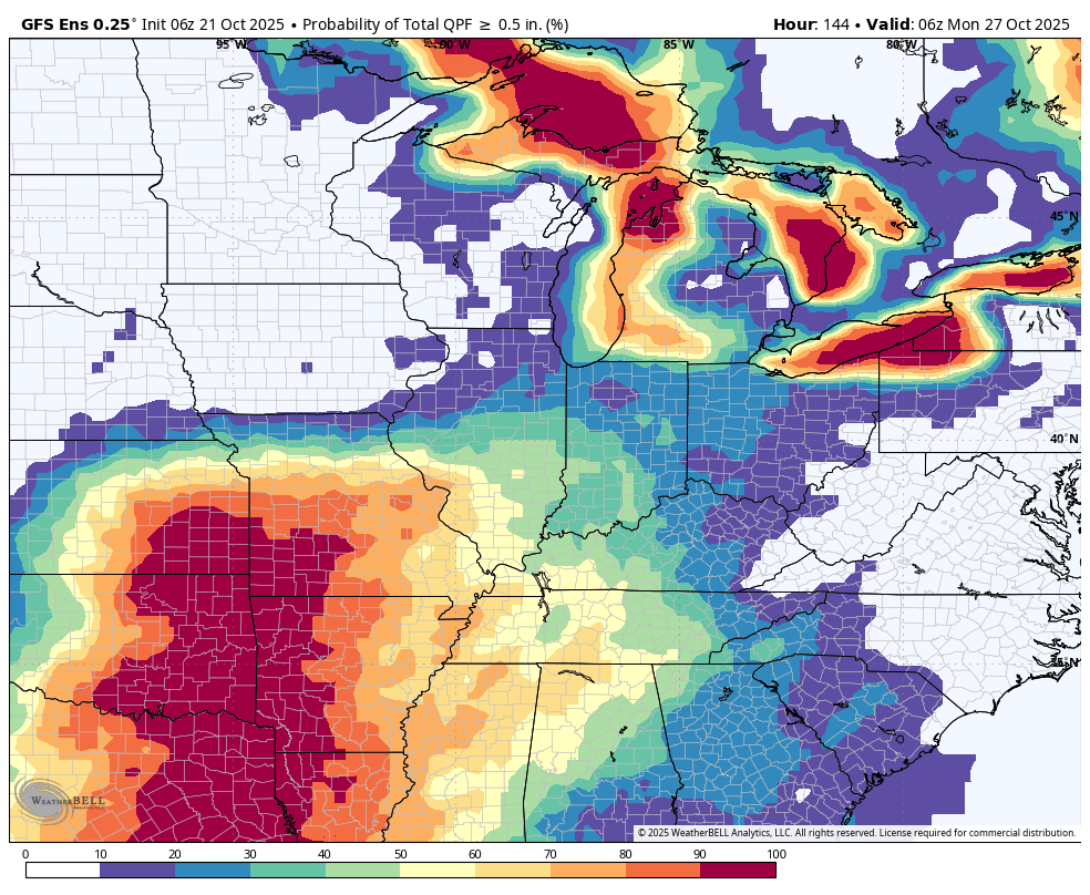
I am watching another system next Monday and Tuesday. A bit early for specifics on that one.
It does appear we will have more rain chances with it. It is too soon to know if severe weather is a concern.
.

.
The timestamp (upper left) is in Zulu. 12z=7 am. 18z=1 pm. 00z=7 pm.
Double-click the animation to enlarge it.
GFS model
.
The timestamp (upper left) is in Zulu. 12z=7 am. 18z=1 pm. 00z=7 pm.
Double-click the animation to enlarge it.
EC model
.
..
.
Click here if you would like to return to the top of the page.
.Average high temperatures for this time of the year are around 72 degrees.
Average low temperatures for this time of the year are around 47 degrees.
Average precipitation during this time period ranges from 1.00″ to 1.25″
Six to Ten Day Outlook.
Blue is below average. Red is above average. The no color zone represents equal chances.
Average highs for this time of the year are in the lower 60s. Average lows for this time of the year are in the lower 40s.

Green is above average precipitation. Yellow and brown favors below average precipitation. Average precipitation for this time of the year is around one inch per week.

.

Average low temperatures for this time of the year are around 45 degrees.
Average precipitation during this time period ranges from 1.00″ to 1.25″
.
Eight to Fourteen Day Outlook.
Blue is below average. Red is above average. The no color zone represents equal chances.

Green is above average precipitation. Yellow and brown favors below average precipitation. Average precipitation for this time of the year is around one inch per week.

.
.
.
We have a new service to complement your www.weathertalk.com subscription. This does NOTreplace www.weathertalk.com It is simply another tool for you to receive severe weather information.
.
https://weathercallservices.com/beau-dodson-weather


Want to receive the daily forecast/other products on your Beau Dodson Weather app?
Did you know you have four options in your www.weathertalk.com account
You will then receive these via your Beau Dodson Weather app.
Just log into your www.weathertalk.com account
Click the NOTIFICATION SETTINGS TAB
Then, turn them on (green) and off (red)
🌪️ Number 1 is the most important one. Severe alerts, tornado alerts, and so on.
Number 2 is the daily video, blog, livestream alerts, and severe weather Facebook threads on severe days or winter storm days.
Number 3 is the daily forecast. I send that out every day during the afternoon hours. It is the seven-day forecast, hazardous weather outlook, fire outlook, and more.
Number 4 is to receive the daily video, blog, and other content on NON-severe weather days (every day without severe threats in other words)
GREEN IS ON
RED IS OFF

I am going to start going live during bigger severe weather events.
Check it out here https://www.youtube.com/user/beaudodson
Click the subscribe button (it’s a free subscription button), and it will alert you when I go live. I will also send out alerts to the app when I go live for an event.

.

Radars and Lightning Data
Interactive-city-view radars. Clickable watches and warnings.
https://wtalk.co/B3XHASFZ
Old legacy radar site (some of you like it better)
https://weatherobservatory.com/weather-radar.htm
If the radar is not updating then try another one. If a radar does not appear to be refreshing then hit Ctrl F5. You may also try restarting your browser.
Backup radar site in case the above one is not working.
https://weathertalk.com/morani
Regional Radar
https://imagery.weathertalk.com/prx/RadarLoop.mp4
** NEW ** Zoom radar with chaser tracking abilities!
ZoomRadar
If the radar is not working, then email me: Email me at beaudodson@usawx.com
.
We do have some sponsors! Check them out.
Roof damage from recent storms? Link – Click here
INTEGRITY ROOFING AND EXTERIORS!
⛈️ Roof or gutter damage from recent storms? Today’s weather is sponsored by Integrity Roofing. Check out their website at this link https://www.ourintegritymatters.com/

![]()
![]()
![]()
Make sure you have three to five ways of receiving your severe weather information.
Weather Talk is one of those ways! Now, I have another product for you and your family.

.
Want to add more products to your Beau Dodson Weather App?
Receive daily videos, weather blog updates on normal weather days and severe weather and winter storm days, your county by county weather forecast, and more!
Here is how to do add those additional products to your app notification settings!
Here is a video on how to update your Beau Dodson Weather payment.
The app is for subscribers. Subscribe at www.weathertalk.com/welcome then go to your app store and search for WeatherTalk
Subscribers, PLEASE USE THE APP. ATT and Verizon are not reliable during severe weather. They are delaying text messages.
The app is under WeatherTalk in the app store.

Apple users click here

Android users click here
.
Radars and Lightning Data
Interactive-city-view radars. Clickable watches and warnings.
https://wtalk.co/B3XHASFZ
Old legacy radar site (some of you like it better)
https://weatherobservatory.com/weather-radar.htm
If the radar is not updating then try another one. If a radar does not appear to be refreshing then hit Ctrl F5. You may also try restarting your browser.
Backup radar site in case the above one is not working.
https://weathertalk.com/morani
Regional Radar
https://imagery.weathertalk.com/prx/RadarLoop.mp4
** NEW ** Zoom radar with chaser tracking abilities!
ZoomRadar
Lightning Data (zoom in and out of your local area)
https://wtalk.co/WJ3SN5UZ
Not working? Email me at beaudodson@usawx.com
National map of weather watches and warnings. Click here.
Storm Prediction Center. Click here.
Weather Prediction Center. Click here.
.

Live lightning data: Click here.
Real time lightning data (another one) https://map.blitzortung.org/#5.02/37.95/-86.99
Our new Zoom radar with storm chases
.
.

Interactive GOES R satellite. Track clouds. Click here.
GOES 16 slider tool. Click here.
College of DuPage satellites. Click here
.

Here are the latest local river stage forecast numbers Click Here.
Here are the latest lake stage forecast numbers for Kentucky Lake and Lake Barkley Click Here.
.
.
Find Beau on Facebook! Click the banner.


 .
.