
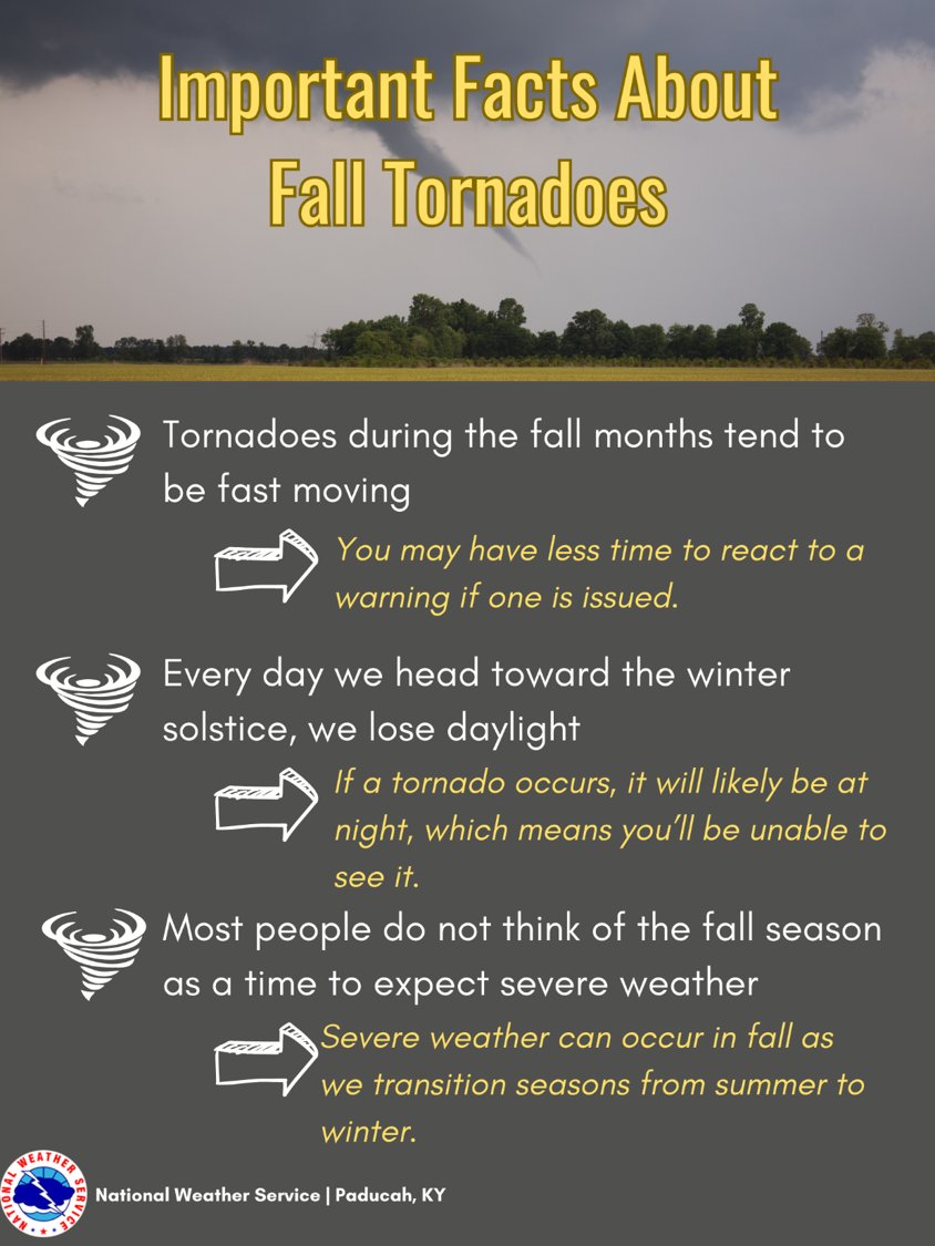
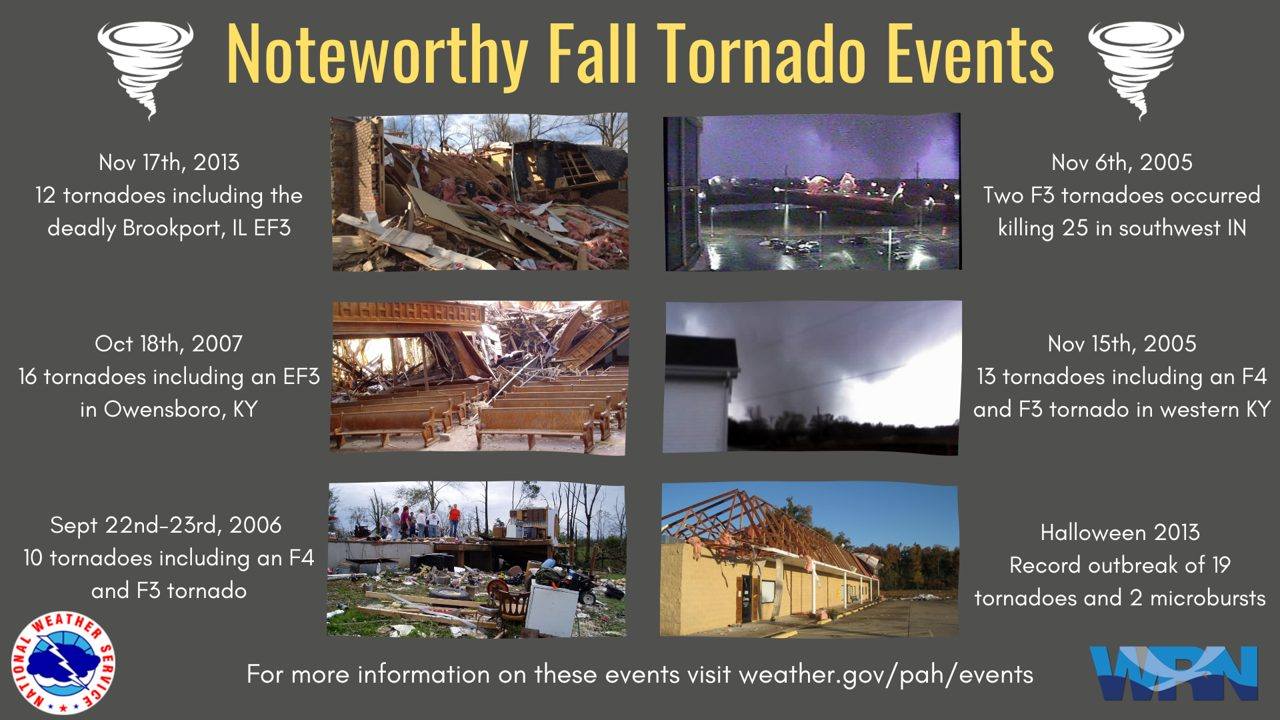
Don’t forget, this week is Severe Weather Preparedness Week. We often have severe weather during October and November.
Have three to five ways of receiving your severe weather warnings.
 .
.
.
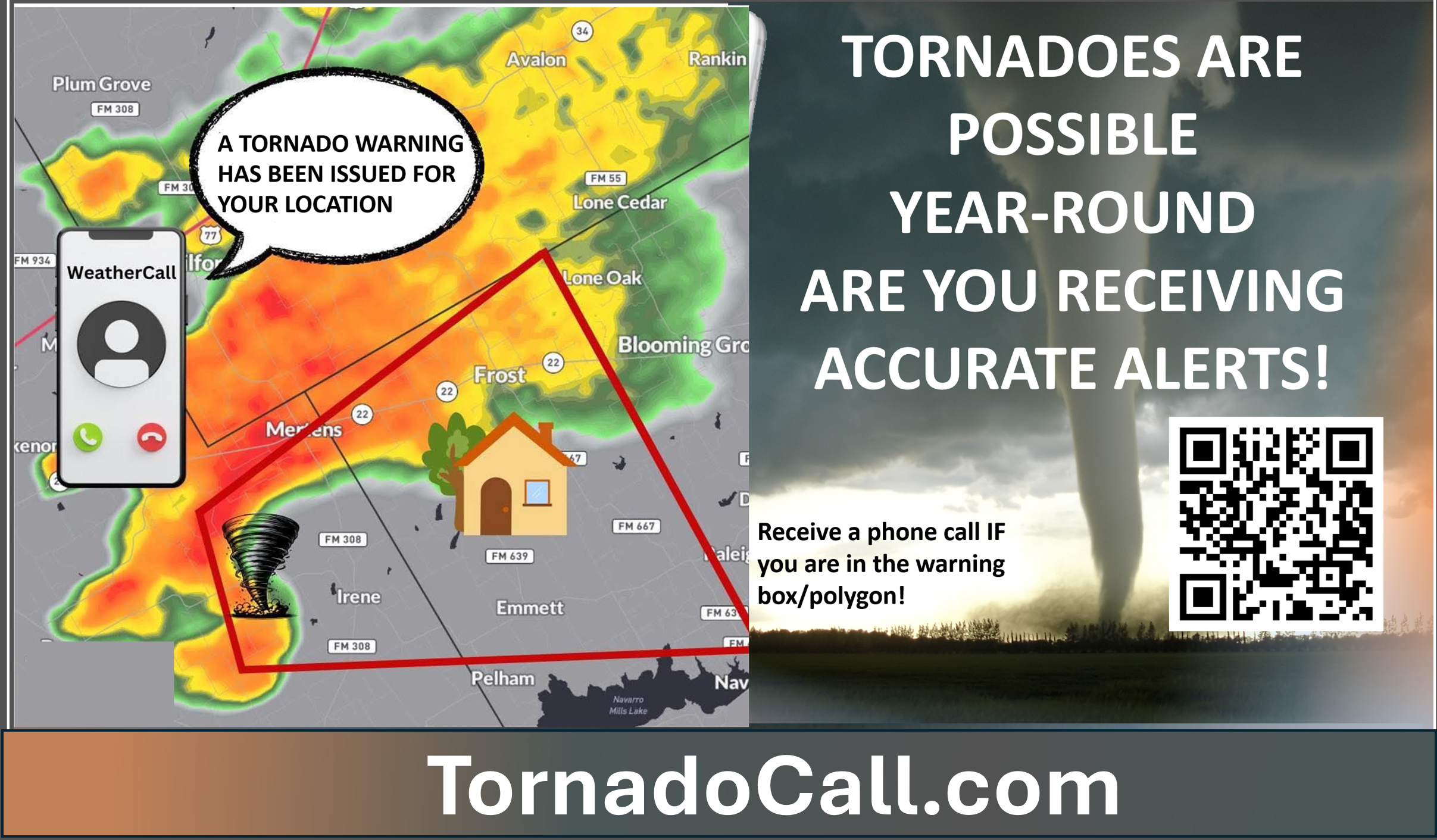
🌪️ NEW SERVICE 🌪️ I have partnered with WeatherCall to bring you an added layer of protection.
WeatherCall will call your cell phone or home number if your home is in a tornado or severe thunderstorm warning. It only calls you if your home is inside the warning box. If you are outside the warning box, it will not disturb you.
More information on the WeatherCall subscription service is here.
www.tornadocall.com
YouTube Video
https://www.youtube.com/watch?v=ve2UY2mAkEI
What the tornado warning sounds like
https://www.youtube.com/watch?v=MXBc03tW_N0
.

.
I have some question-and-answer threads over on the Facebook page. Link to those threads CLICK HERE
Or email me at beaudodsonweather@gmail.com
..

🌪️ Seven-Day Tornado Outlook ⛈️
October 1st through October 8th
Current risk: NO
Current confidence level: High confidence in the forecast.
Comments: Tornadoes are not in the forecast.
.

Seven-Day Hazardous Weather Outlook
1. Is lightning in the forecast? MONITOR. I will monitor next Monday through Wednesday.
2. Are organized/widespread severe thunderstorms in the forecast? NO.
3. Is flash flooding in the forecast? NO.
4. Will non-thunderstorm winds top 40 mph? NO.
5. Will temperatures rise above 90 degrees? SCATTERED. A few spots could hit the 90 mark today.
6. Will temperatures rise above 100 degrees? NO.
7. Will the heat index (feels like) rise above 100 degrees? NO.
8. Will the heat index rise above 115 degrees? NO.
9. Will the temperature fall below 32 degrees? NO.
.
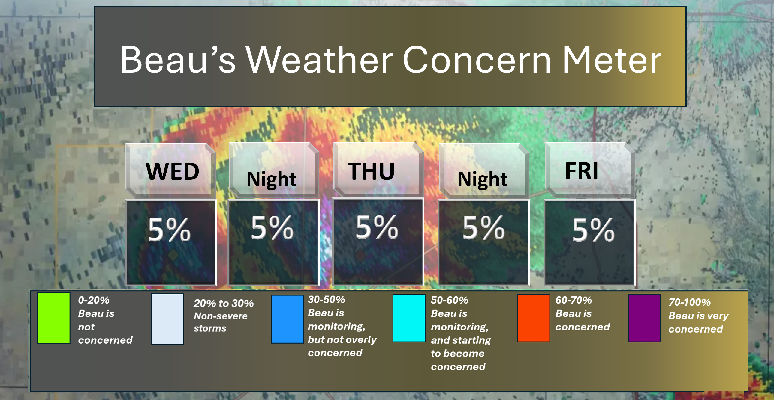
Here is the short-range concern meter.
No significant concerns.
.
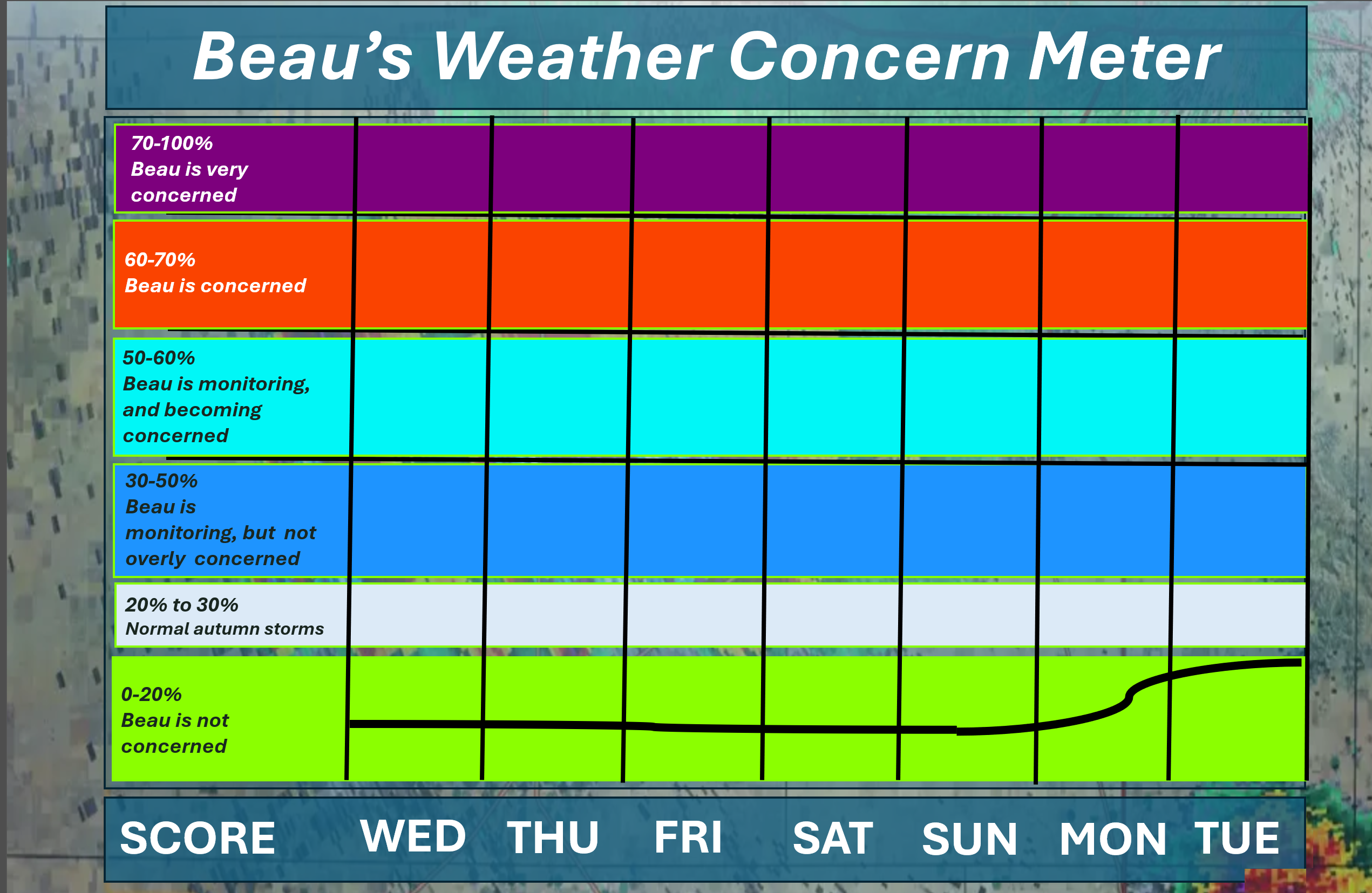
Here is the extended concern meter. This takes us through next Tuesday.
No significant concerns.
.
A quick forecast glance. Your 48-hour forecast Graphics


.
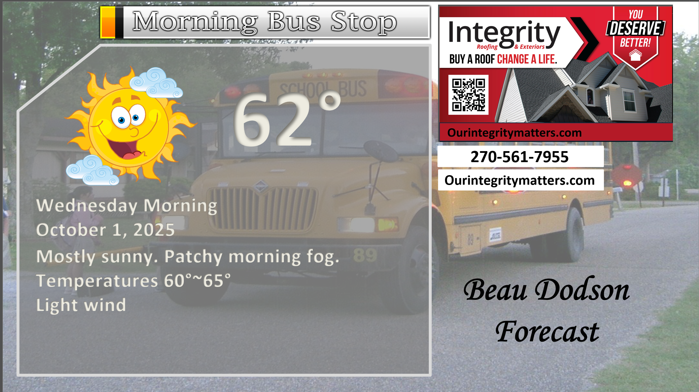
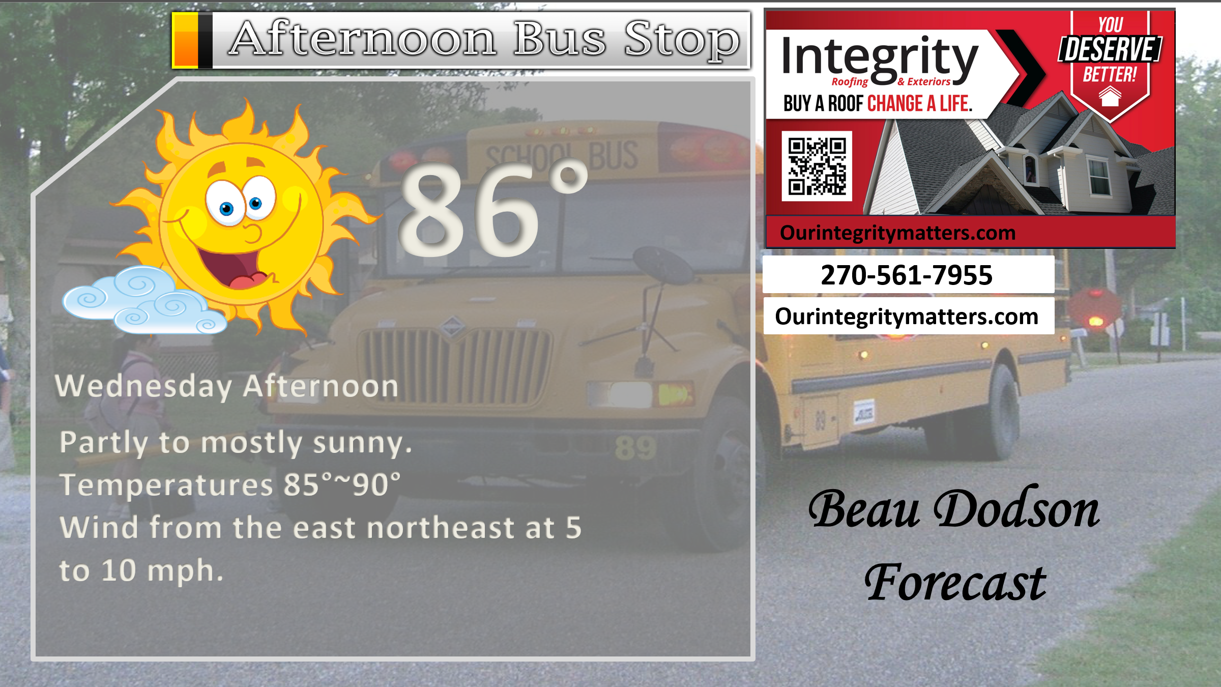
Here is your bus stop forecast.
.
This afternoon
.


Forecast discussion
- Nice/warm weather. Mostly sunny days. Clear nights.
- Above-average temperatures through the weekend.
- Slightly cooler by the weekend.
- Dry conditions through at least Sunday morning.
- Monitoring shower chances next week.
.
 .
.
.
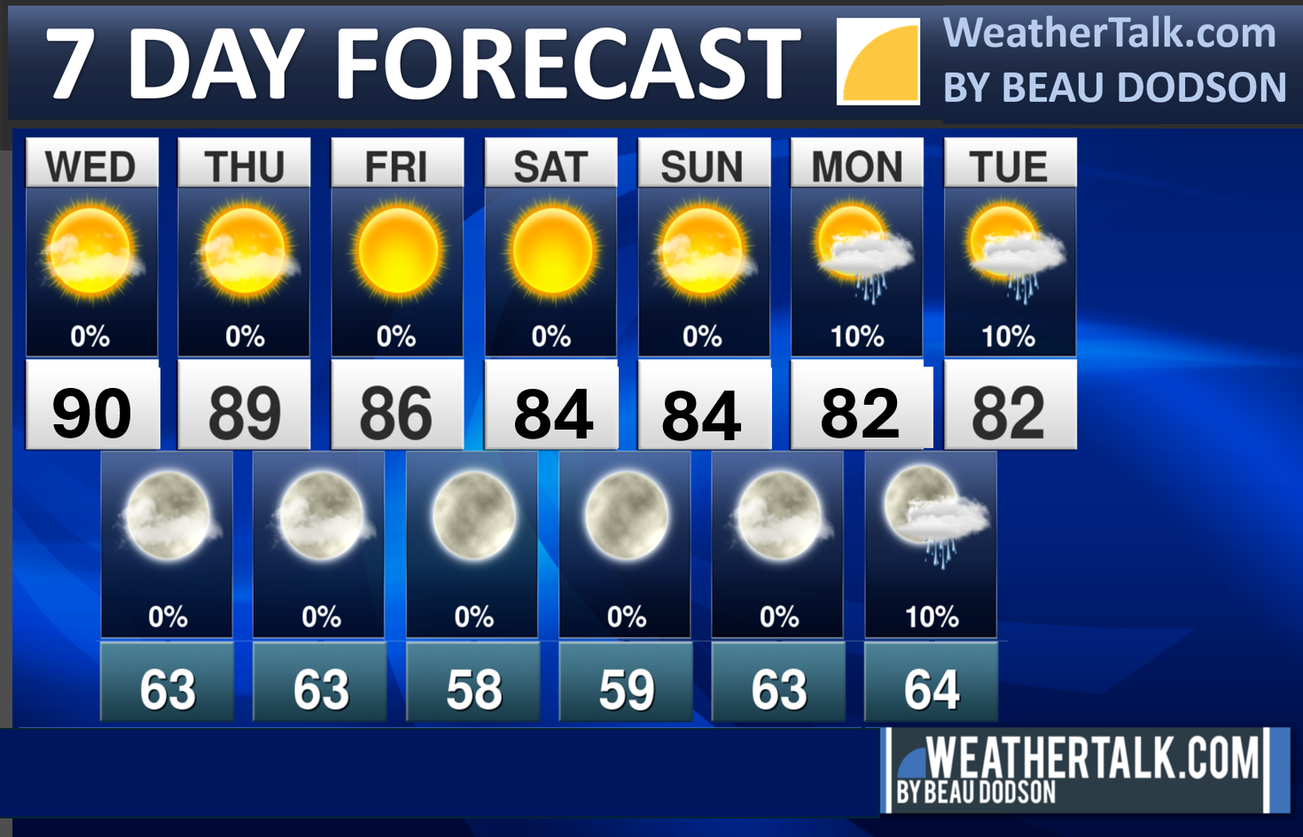
Seven-day outlook graphic.
.
Welcome to October!
No changes to the going forecast through Sunday.
It will be warm this week, with above-average temperatures expected to persist through the weekend. Temperatures will be 10 degrees above average during the day.
Then, temperatures are expected to drop slightly by this weekend and early next week. It will still be in the eighties.
Average highs for this time of the year are around 78 degrees. Average lows are around 54 degrees.
It will be dry this week. Calm weather. No concerns.
I am monitoring next Monday, Tuesday, and Wednesday for a few showers.
Winds will turn out of the south this weekend. This will bring an increase in moisture levels. That could lead to a few showers by early next week. For now, I kept Monday dry, but in future updates, I may need to add a few showers.
Overall, the October forecast is for below-average precipitation and above-average temperatures. That does not mean no cool air. It means that when you average all 31 days, it will likely result in a below-average outcome.
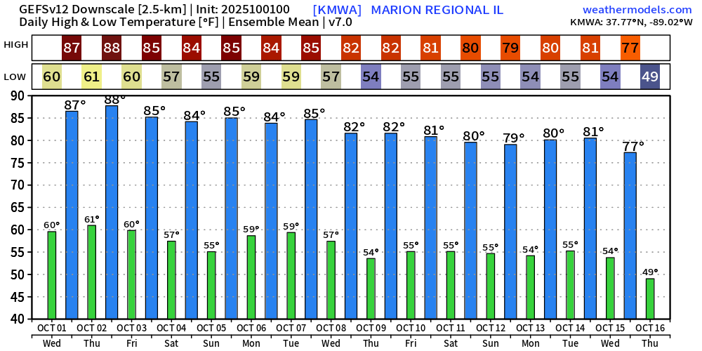
Here is what the ensembles are showing for temperatures.
Long-range GEFS ensembles temperatures. Warm.
I am watching a cold front around the 10th to 15th.

.
The timestamp (upper left) is in Zulu. 12z=7 am. 18z=1 pm. 00z=7 pm.
Double-click the animation to enlarge it.
NAM 3K model
NO RAIN
.
The timestamp (upper left) is in Zulu. 12z=7 am. 18z=1 pm. 00z=7 pm.
Double-click the animation to enlarge it.
Hrrr model
NO RAIN
.
..
.
Click here if you would like to return to the top of the page.
.Average high temperatures for this time of the year are around 78 degrees.
Average low temperatures for this time of the year are around 54 degrees.
Average precipitation during this time period ranges from 1.00″ to 1.25″
Six to Ten Day Outlook.
Blue is below average. Red is above average. The no color zone represents equal chances.
Average highs for this time of the year are in the lower 60s. Average lows for this time of the year are in the lower 40s.

Green is above average precipitation. Yellow and brown favors below average precipitation. Average precipitation for this time of the year is around one inch per week.

.

Average low temperatures for this time of the year are around 51 degrees.
Average precipitation during this time period ranges from 1.00″ to 1.25″
.
Eight to Fourteen Day Outlook.
Blue is below average. Red is above average. The no color zone represents equal chances.

Green is above average precipitation. Yellow and brown favors below average precipitation. Average precipitation for this time of the year is around one inch per week.

.
.
.
We have a new service to complement your www.weathertalk.com subscription. This does NOTreplace www.weathertalk.com It is simply another tool for you to receive severe weather information.
.
https://weathercallservices.com/beau-dodson-weather


Want to receive the daily forecast/other products on your Beau Dodson Weather app?
Did you know you have four options in your www.weathertalk.com account
You will then receive these via your Beau Dodson Weather app.
Just log into your www.weathertalk.com account
Click the NOTIFICATION SETTINGS TAB
Then, turn them on (green) and off (red)
🌪️ Number 1 is the most important one. Severe alerts, tornado alerts, and so on.
Number 2 is the daily video, blog, livestream alerts, and severe weather Facebook threads on severe days or winter storm days.
Number 3 is the daily forecast. I send that out every day during the afternoon hours. It is the seven-day forecast, hazardous weather outlook, fire outlook, and more.
Number 4 is to receive the daily video, blog, and other content on NON-severe weather days (every day without severe threats in other words)
GREEN IS ON
RED IS OFF

I am going to start going live during bigger severe weather events.
Check it out here https://www.youtube.com/user/beaudodson
Click the subscribe button (it’s a free subscription button), and it will alert you when I go live. I will also send out alerts to the app when I go live for an event.

.

Radars and Lightning Data
Interactive-city-view radars. Clickable watches and warnings.
https://wtalk.co/B3XHASFZ
Old legacy radar site (some of you like it better)
https://weatherobservatory.com/weather-radar.htm
If the radar is not updating then try another one. If a radar does not appear to be refreshing then hit Ctrl F5. You may also try restarting your browser.
Backup radar site in case the above one is not working.
https://weathertalk.com/morani
Regional Radar
https://imagery.weathertalk.com/prx/RadarLoop.mp4
** NEW ** Zoom radar with chaser tracking abilities!
ZoomRadar
If the radar is not working, then email me: Email me at beaudodson@usawx.com
.
We do have some sponsors! Check them out.
Roof damage from recent storms? Link – Click here
INTEGRITY ROOFING AND EXTERIORS!
⛈️ Roof or gutter damage from recent storms? Today’s weather is sponsored by Integrity Roofing. Check out their website at this link https://www.ourintegritymatters.com/

![]()
![]()
![]()
Make sure you have three to five ways of receiving your severe weather information.
Weather Talk is one of those ways! Now, I have another product for you and your family.

.
Want to add more products to your Beau Dodson Weather App?
Receive daily videos, weather blog updates on normal weather days and severe weather and winter storm days, your county by county weather forecast, and more!
Here is how to do add those additional products to your app notification settings!
Here is a video on how to update your Beau Dodson Weather payment.
The app is for subscribers. Subscribe at www.weathertalk.com/welcome then go to your app store and search for WeatherTalk
Subscribers, PLEASE USE THE APP. ATT and Verizon are not reliable during severe weather. They are delaying text messages.
The app is under WeatherTalk in the app store.

Apple users click here

Android users click here
.
Radars and Lightning Data
Interactive-city-view radars. Clickable watches and warnings.
https://wtalk.co/B3XHASFZ
Old legacy radar site (some of you like it better)
https://weatherobservatory.com/weather-radar.htm
If the radar is not updating then try another one. If a radar does not appear to be refreshing then hit Ctrl F5. You may also try restarting your browser.
Backup radar site in case the above one is not working.
https://weathertalk.com/morani
Regional Radar
https://imagery.weathertalk.com/prx/RadarLoop.mp4
** NEW ** Zoom radar with chaser tracking abilities!
ZoomRadar
Lightning Data (zoom in and out of your local area)
https://wtalk.co/WJ3SN5UZ
Not working? Email me at beaudodson@usawx.com
National map of weather watches and warnings. Click here.
Storm Prediction Center. Click here.
Weather Prediction Center. Click here.
.

Live lightning data: Click here.
Real time lightning data (another one) https://map.blitzortung.org/#5.02/37.95/-86.99
Our new Zoom radar with storm chases
.
.

Interactive GOES R satellite. Track clouds. Click here.
GOES 16 slider tool. Click here.
College of DuPage satellites. Click here
.

Here are the latest local river stage forecast numbers Click Here.
Here are the latest lake stage forecast numbers for Kentucky Lake and Lake Barkley Click Here.
.
.
Find Beau on Facebook! Click the banner.


 .
.