

.
I have some question-and-answer threads over on the Facebook page. Link to those threads CLICK HERE
Or email me at beaudodsonweather@gmail.com
.

🌪️ Seven-Day Tornado Outlook ⛈️
May 7th through May 13th
Current risk: Currently, we do not have tornadoes in the forecast.
I will monitor next Monday and Tuesday. I am monitoring the long range (around the 15th onward).
Current confidence level: High confidence in the current forecast.
Comment:
.

Seven-Day Hazardous Weather Outlook
1. Is lightning in the forecast? SCATTERED. Scattered lightning is possible today into Thursday evening. Another chance on Monday and Tuesday.
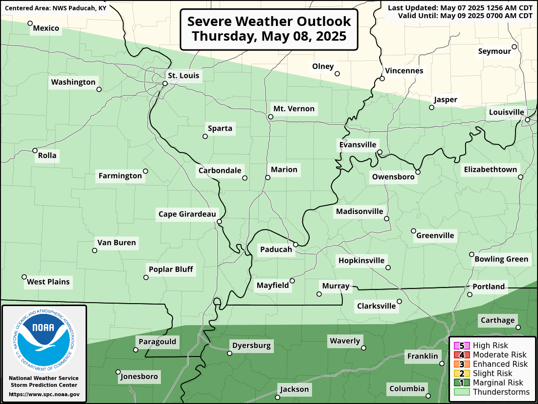
2. Are severe thunderstorms in the forecast? LOW RISK. A couple of storms could be intense on Thursday afternoon. The SPC has placed the southern part of the Bootheel and western Tennessee in a level one (lowest) risk. See graphic below.
The primary concern will be isolated gusty winds and small hail. I will monitor next Monday and Tuesday.
3. Is flash flooding in the forecast? NO.
4. Will non-thunderstorm winds top 40 mph? NO.
5. Will temperatures rise above 90 degrees? NO.
6. Will the heat index rise above 100 degrees? NO.
.
A quick forecast glance. Your 48-hour forecast Graphics


.


.


Forecast discussion.
- Mostly mild temperatures into next week. A bit warmer next week.
- Scattered showers and thunderstorms today into Thursday evening. A small chance on Friday and Saturday. Increasing chances again on Sunday, Monday, and Tuesday.
- A marginal risk of intense storms on Thursday afternoon over mainly our southern counties.
- Watching the long-range severe weather forecast.
.

.
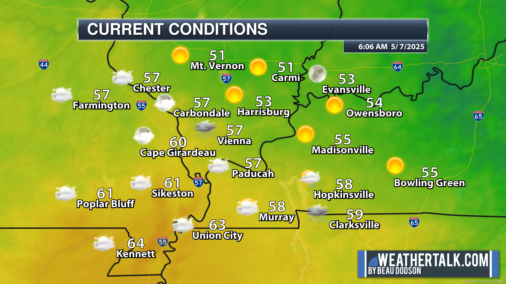
Good morning, everyone.
We are waking up to a variety of temperatures. Warmer air is approaching from the south.
Mt Vernon, Illinois, dipped down to a cool 50 degrees. Meanwhile, temperatures over portions of the Bootheel were in the mid-60s.
.
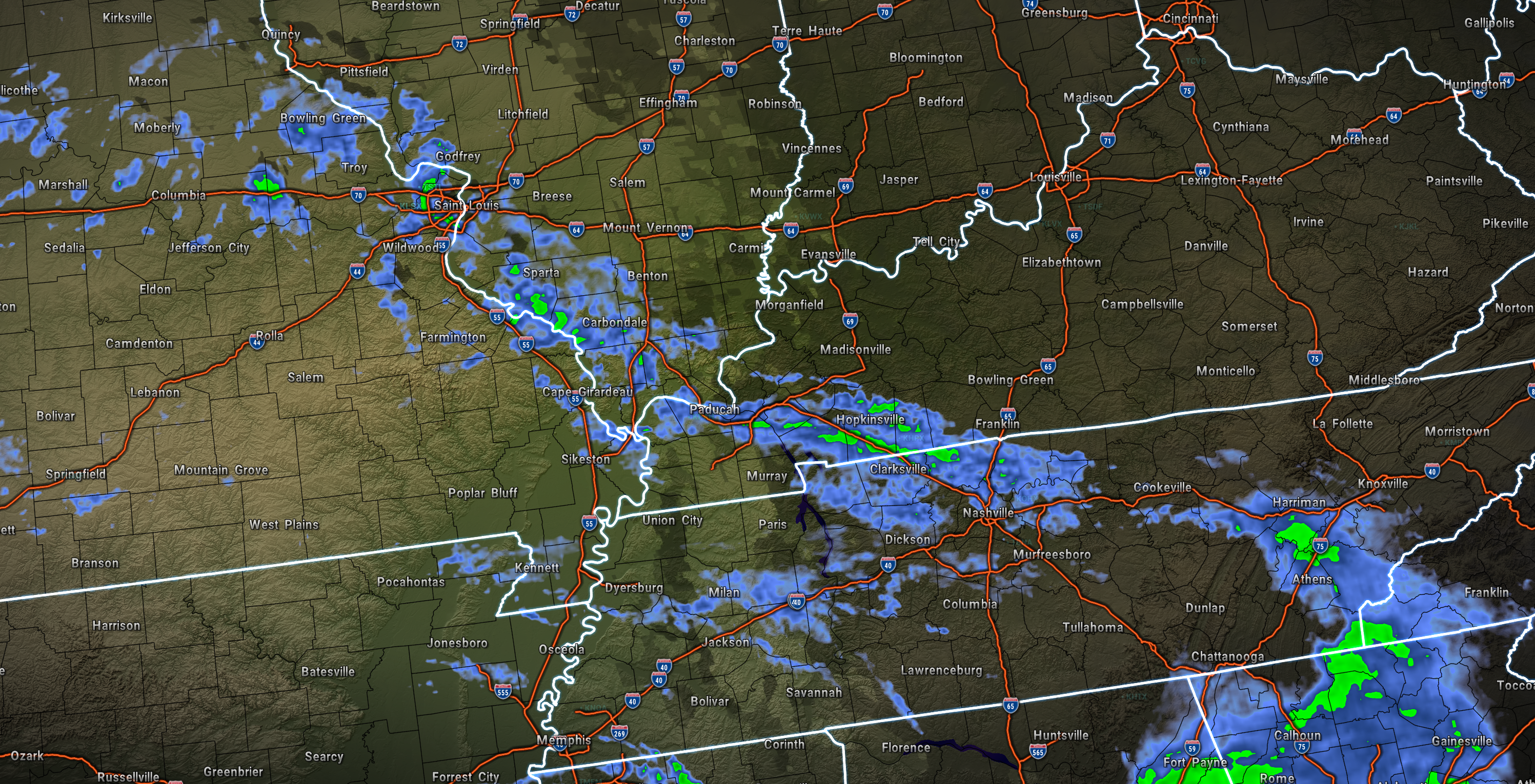
Radar showed a few showers moving northeast through the region.
6:15 AM radar
.
The weather will be unsettled today through Thursday. Another upper-level low-pressure center will push across our region. This will bring showers and thunderstorms.
Today’s activity will be scattered. Not everyone will experience showers, but there will be showers on the weather radars.
Same for tonight.
Chances for showers and thunderstorms will increase on Thursday. A few of the thunderstorms could be strong with gusty winds and hail.
For now, the SPC has a risk across the Missouri Bootheel and western Tennessee.
If instability is a bit higher, then they could move that northward just a tad.
Either way, this is not a significant severe weather outbreak/event. It is a low-end risk that a couple of storms will produce strong winds/downburst winds and nickel-sized hail. Lightning, of course.
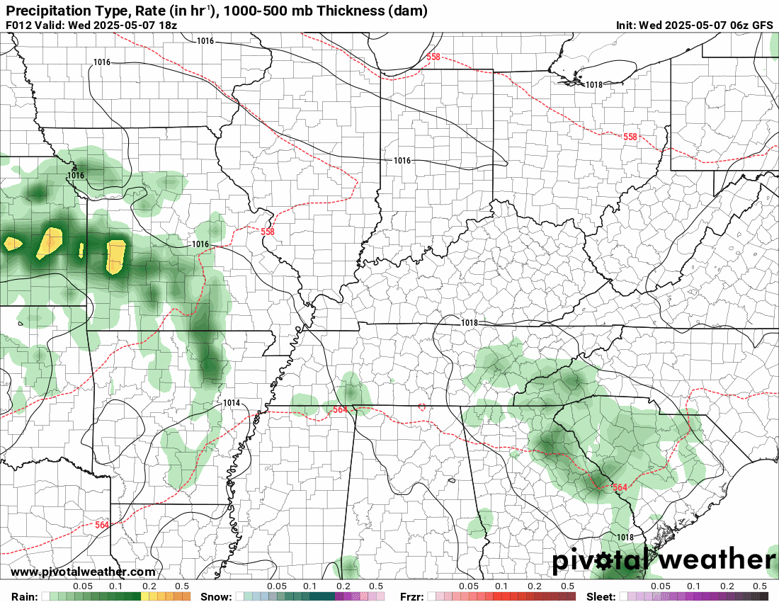
Here is the severe weather outlook for Thursday.
.
We will have a low-end chance of showers lingering into Friday and Saturday.
Yet another system will push into the region by Sunday and Monday of next week. This will bring additional showers and thunderstorms.
You can see that system on the 500 MB vorticity map. Spiralling into the region from the south southwest.
This shows you areas of lift.

.
There remain some questions about the coverage of precipitation on Sunday. For now, I left it at 30%-40%. I will need to monitor it. Some data shows higher rain probabilities.
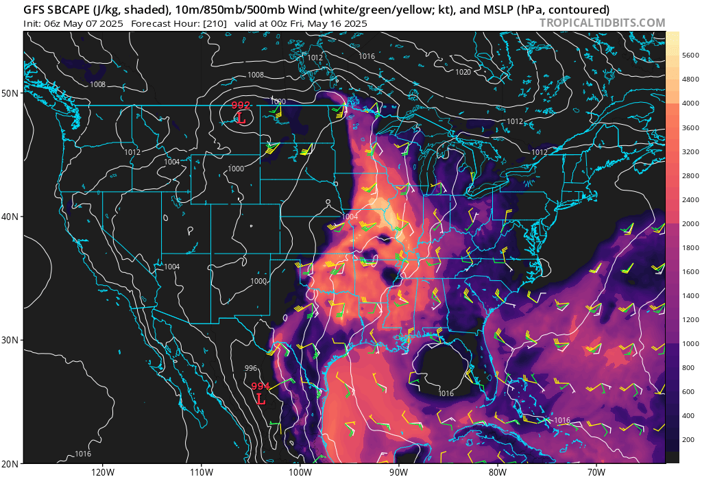
A few of the storms on Monday and Tuesday could be strong with gusty winds and nickel-sized hail. There will be more instability on Monday and Tuesday with warmer air moving into the region. I will monitor it, of course.
I continue to watch the 15th through 25th time frame. Data has been showing higher instability levels during that time frame.
Typically, May is our peak tornado season. So severe weather would not be a surprise. I will be monitoring trends.
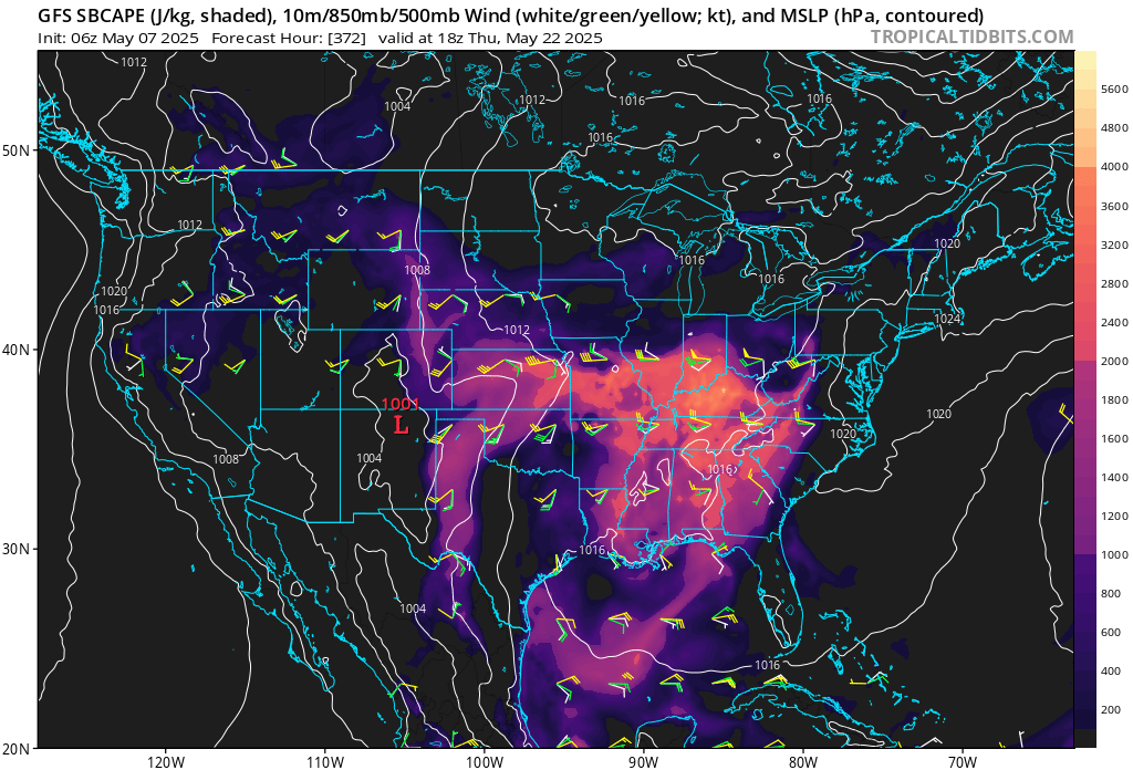
You can see that instability on the GFS model.
This is CAPE. CAPE is energy for thunderstorms to tap into.
May 15th and 16th
May 17th and 18th
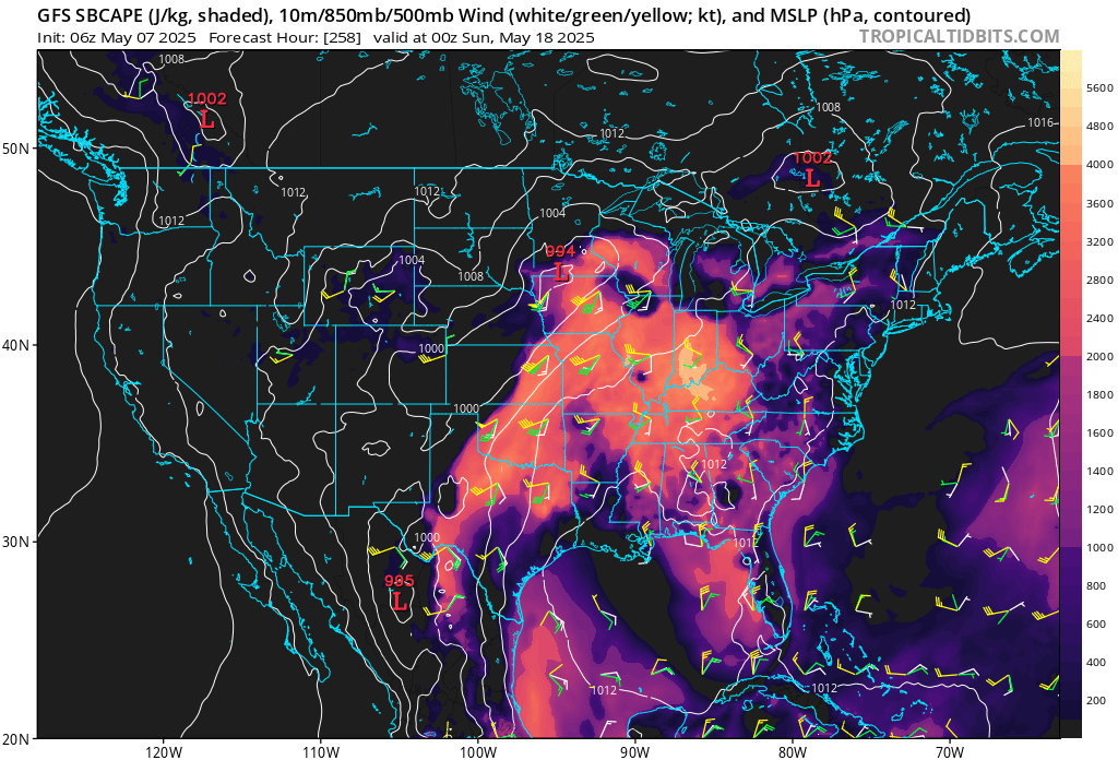
May 21st and 22nd
.

The timestamp (upper left) is in Zulu. 12z=7 am. 18z=1 pm. 00z=7 pm.
Double-click the animation to enlarge it.
GFS model.
.
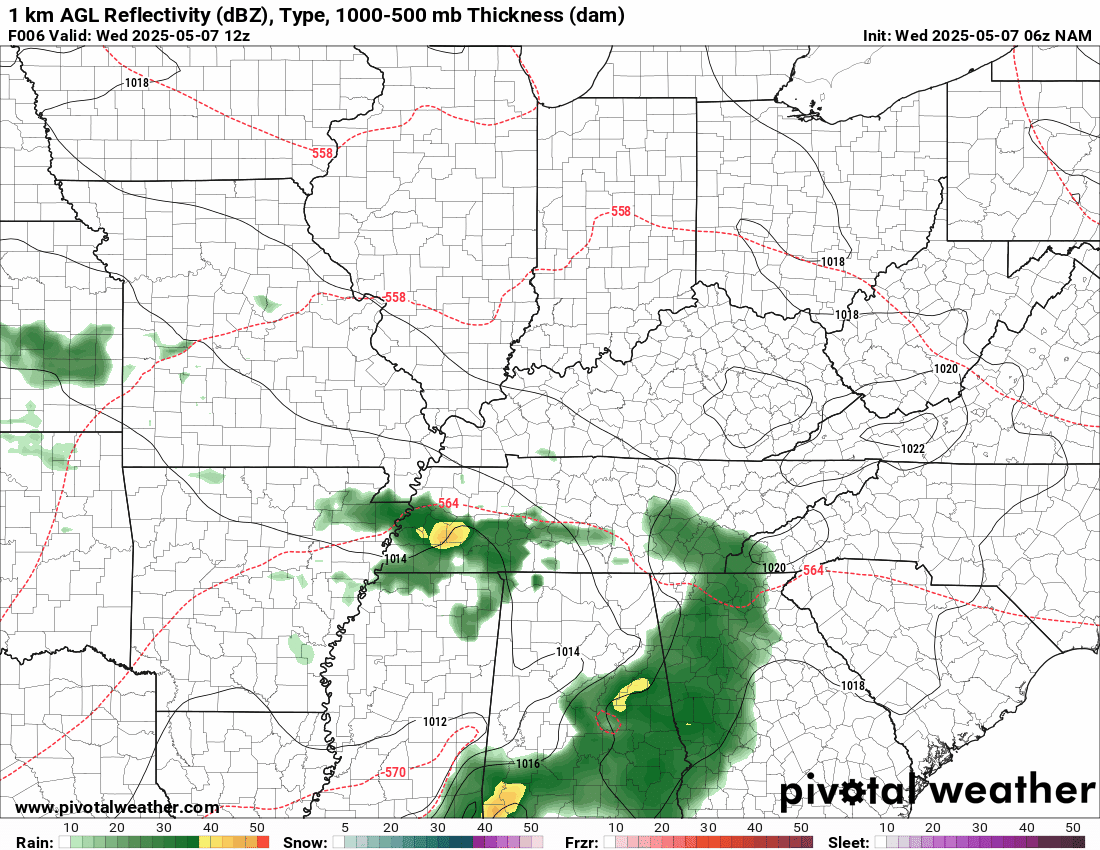
Here is the NAM model.
.
.
.
Click here if you would like to return to the top of the page.
.Average high temperatures for this time of the year are around 73 degrees.
Average low temperatures for this time of the year are around 52 degrees.
Average precipitation during this time period ranges from 1.00″ to 1.40″
Six to Ten Day Outlook.
Blue is below average. Red is above average. The no color zone represents equal chances.
Average highs for this time of the year are in the lower 60s. Average lows for this time of the year are in the lower 40s.

Green is above average precipitation. Yellow and brown favors below average precipitation. Average precipitation for this time of the year is around one inch per week.

.

Average low temperatures for this time of the year are around 55 degrees.
Average precipitation during this time period ranges from 1.20″ to 1.50″
.
Eight to Fourteen Day Outlook.
Blue is below average. Red is above average. The no color zone represents equal chances.

Green is above average precipitation. Yellow and brown favors below average precipitation. Average precipitation for this time of the year is around one inch per week.

.
.
.
We have a new service to complement your www.weathertalk.com subscription. This does NOT replace www.weathertalk.com It is simply another tool for you to receive severe weather information.
.


.

Radars and Lightning Data
Interactive-city-view radars. Clickable watches and warnings.
https://wtalk.co/B3XHASFZ
Old legacy radar site (some of you like it better)
https://weatherobservatory.com/weather-radar.htm
If the radar is not updating then try another one. If a radar does not appear to be refreshing then hit Ctrl F5. You may also try restarting your browser.
Backup radar site in case the above one is not working.
https://weathertalk.com/morani
Regional Radar
https://imagery.weathertalk.com/prx/RadarLoop.mp4
** NEW ** Zoom radar with chaser tracking abilities!
ZoomRadar
If the radar is not working, then email me: Email me at beaudodson@usawx.com
.
We do have some sponsors! Check them out.
Roof damage from recent storms? Link – Click here
INTEGRITY ROOFING AND EXTERIORS!
⛈️ Roof or gutter damage from recent storms? Today’s weather is sponsored by Integrity Roofing. Check out their website at this link https://www.ourintegritymatters.com/

![]()
![]()
![]()
Make sure you have three to five ways of receiving your severe weather information.
Weather Talk is one of those ways! Now, I have another product for you and your family.

.
Want to add more products to your Beau Dodson Weather App?
Receive daily videos, weather blog updates on normal weather days and severe weather and winter storm days, your county by county weather forecast, and more!
Here is how to do add those additional products to your app notification settings!
Here is a video on how to update your Beau Dodson Weather payment.
The app is for subscribers. Subscribe at www.weathertalk.com/welcome then go to your app store and search for WeatherTalk
Subscribers, PLEASE USE THE APP. ATT and Verizon are not reliable during severe weather. They are delaying text messages.
The app is under WeatherTalk in the app store.

Apple users click here

Android users click here
.
Radars and Lightning Data
Interactive-city-view radars. Clickable watches and warnings.
https://wtalk.co/B3XHASFZ
Old legacy radar site (some of you like it better)
https://weatherobservatory.com/weather-radar.htm
If the radar is not updating then try another one. If a radar does not appear to be refreshing then hit Ctrl F5. You may also try restarting your browser.
Backup radar site in case the above one is not working.
https://weathertalk.com/morani
Regional Radar
https://imagery.weathertalk.com/prx/RadarLoop.mp4
** NEW ** Zoom radar with chaser tracking abilities!
ZoomRadar
Lightning Data (zoom in and out of your local area)
https://wtalk.co/WJ3SN5UZ
Not working? Email me at beaudodson@usawx.com
National map of weather watches and warnings. Click here.
Storm Prediction Center. Click here.
Weather Prediction Center. Click here.
.

Live lightning data: Click here.
Real time lightning data (another one) https://map.blitzortung.org/#5.02/37.95/-86.99
Our new Zoom radar with storm chases
.
.

Interactive GOES R satellite. Track clouds. Click here.
GOES 16 slider tool. Click here.
College of DuPage satellites. Click here
.

Here are the latest local river stage forecast numbers Click Here.
Here are the latest lake stage forecast numbers for Kentucky Lake and Lake Barkley Click Here.
.
.
Find Beau on Facebook! Click the banner.


 .
.