
.

🌪️ Seven-Day Tornado Outlook ⛈️
May 5th through May 12th
Current risk: A low-level risk this afternoon and tonight. See the graphics below.
Current confidence level: Medium.
Comments: I will monitor this afternoon and tonight. Mainly over southeast Missouri and western Tennessee. Mostly along the MO/AR border. The threat should lessen as you travel into Kentucky and Illinois.
I will send out app alerts if necessary.
.

Seven-Day Hazardous Weather Outlook
1. Is lightning in the forecast? Possible. Today through Wednesday night. Another chance on Friday evening and night. Another chance on Sunday and Monday.
2. Are organized severe thunderstorms. MONITOR. A few storms could be intense this afternoon and tonight. The primary concern will be strong wind gusts and a few reports of large hail. Again, the risk is higher over southern Missouri, the Missouri Bootheel, and western Tennessee.
3. Is significant or widespread flash flooding in the forecast? UNLIKELY. If thunderstorms track over the same areas from today into tomorrow, a few areas could see ditch and small stream flooding. Common areas that have issues when heavy rain occurs.
4. Will non-thunderstorm winds top 40 mph? NO.
5. Will the temperature rise above 90 degrees? NO.
6. Is the heat index forecast to rise above 100 degrees? NO.
.
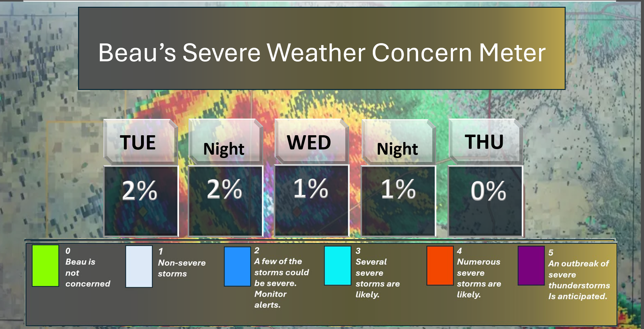
⛈️ Here is the short-range thunderstorm concern meter.
.
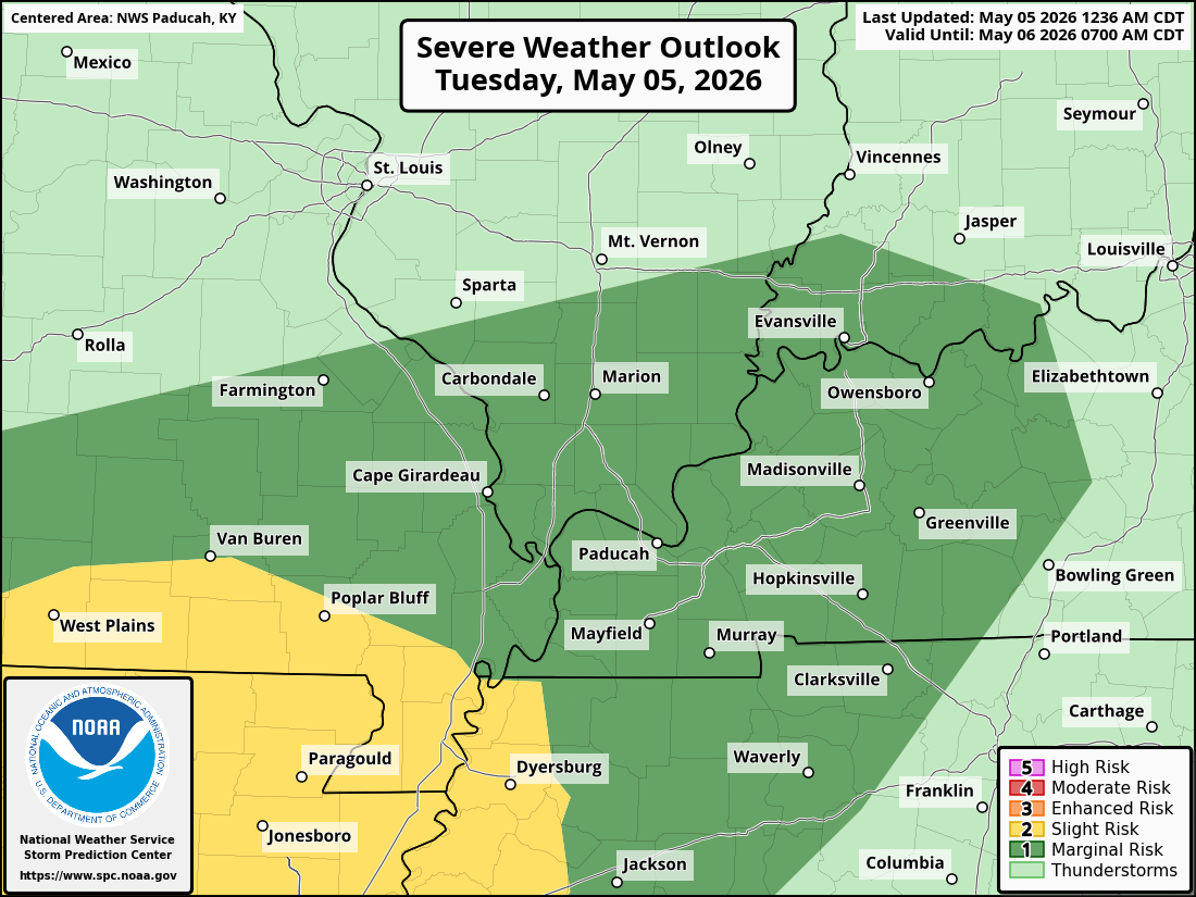
Here is today’s Storm Prediction Center’s (NOAA/NWS) severe weather Outlook.
It appears the risk is mainly across portions of southeast Missouri and western Tennessee.
Whether it reaches into Kentucky and Illinois is questionable. Instability may struggle in those areas. I will monitor it.
They did expand the dark green zone a bit farther north and east.
Here is the day one severe weather outlook.
The dark green zone is a low-level one risk. The yellow zone is a level two risk. The scale ranges from 1 to 5 (one being the lowest).
The light green zone is where thunderstorms are possible, but they should remain below severe levels.
.
Here is the damaging wind graphic. The brown zone is a low risk. The yellow zone is a slightly high-risk zone.
Damaging winds would be 60 mph winds or greater.

.
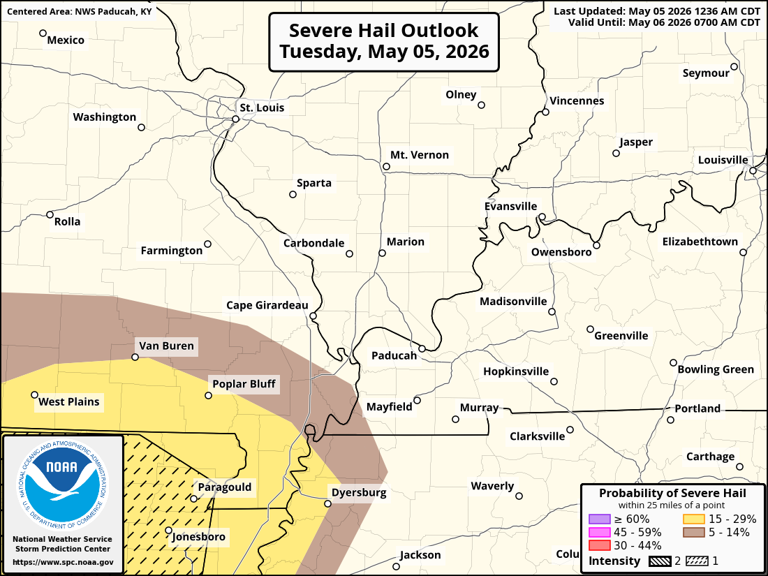
Here is the hail outlook. Severe hail is considered to be the size of quarters or larger. The hatched zone is where hail could be the size of half-dollars or larger.
.
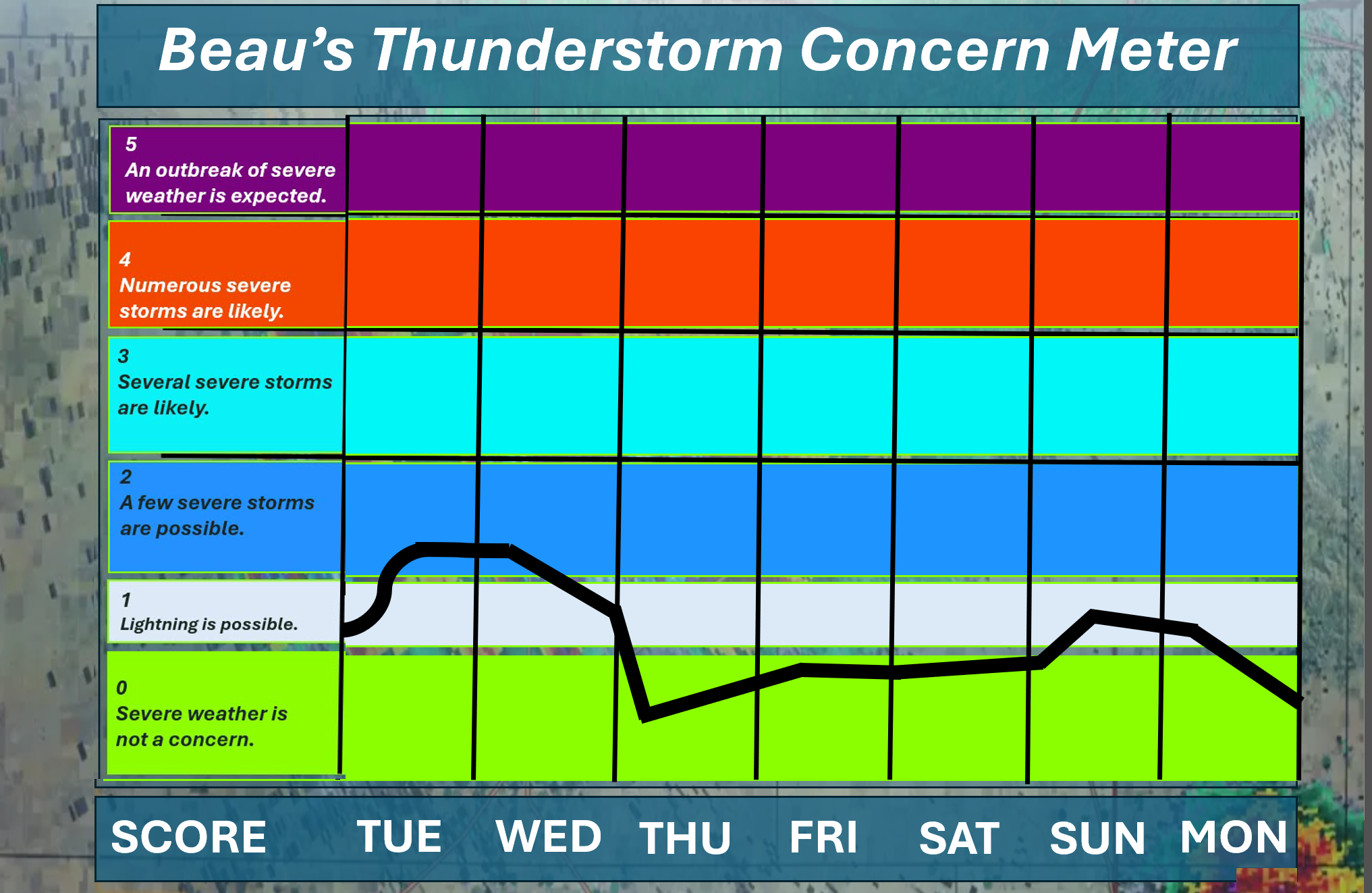
⛈️ Here is the extended thunderstorm concern meter.
.


.
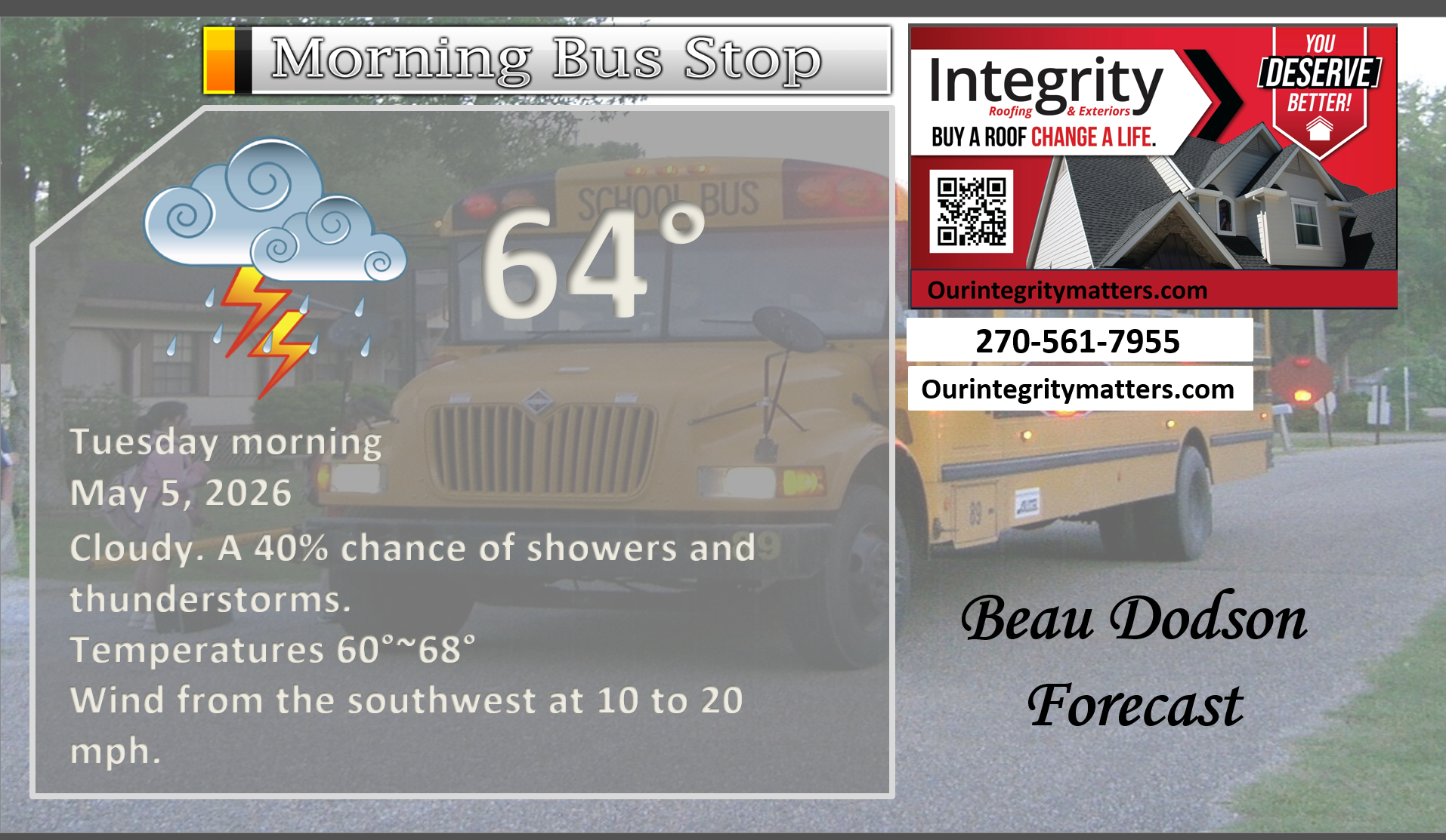
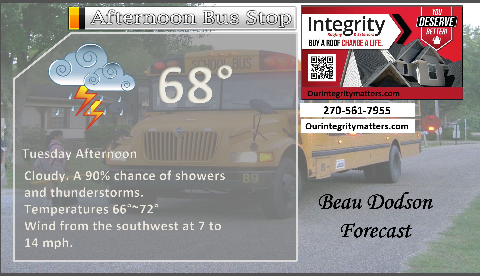
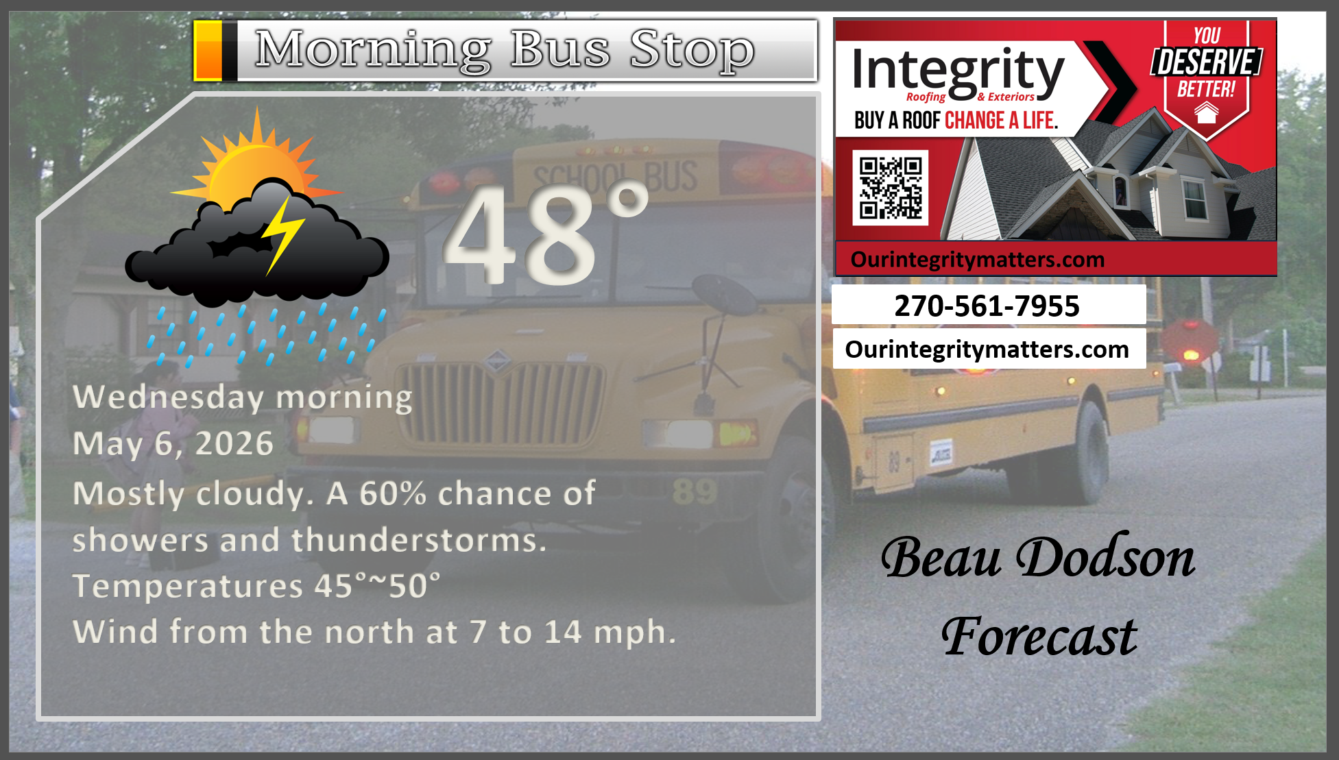
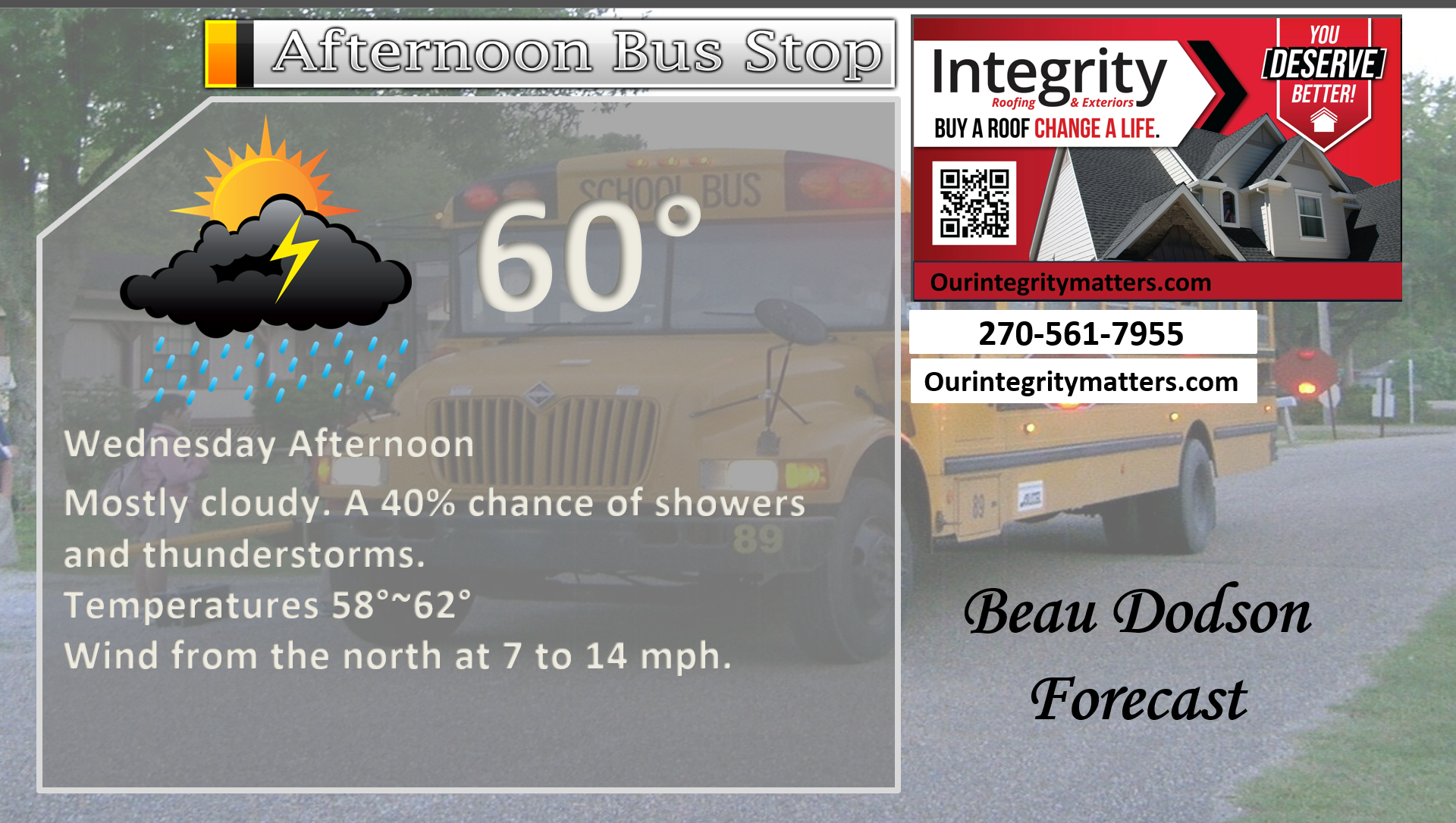
Here is your bus stop forecast
This morning
.
This afternoon
.
.
Tomorrow morning
.
Tomorrow afternoon
.
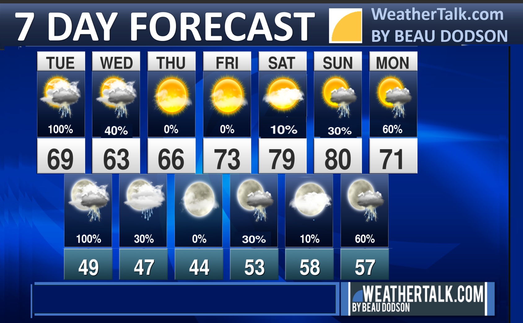
Seven-day outlook graphic.
See the video and graphics below for more details specific to your county. This is a broad-brush overview of the entire region.
.


Forecast discussion
- Unsettled weather today into tomorrow.
- There is a small risk of a few intense storms later today and tonight. Mainly over southeast Missouri and western Tennessee. The risk elsewhere is lower.
- Rainfall totals of one inch are likely across the region. Locally higher amounts are possible.
- On and off cool shots into mid-May.
 .
.
.
What is the primary weather concern today and tonight?
Numerous showers and scattered thunderstorms will move southeast across the entire region today. Rain chances will increase to 80–100% by this afternoon and evening, meaning most areas will see rain.
There is a small chance that a few storms could become strong or severe this afternoon or evening, but the better chances for severe weather are expected to stay south of our area.
Rainfall totals are expected to average between 0.80″ and 1.60″, although some areas could receive more. The rain should help improve ongoing drought conditions in the region.
.
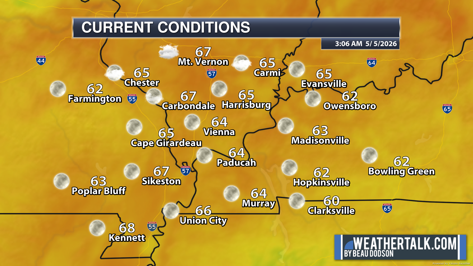
Here are the early morning current conditions. These are the 4 AM readings.
.
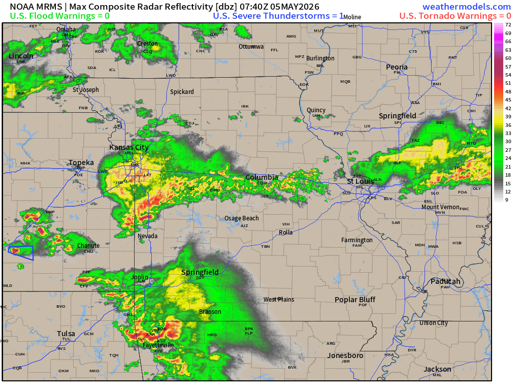
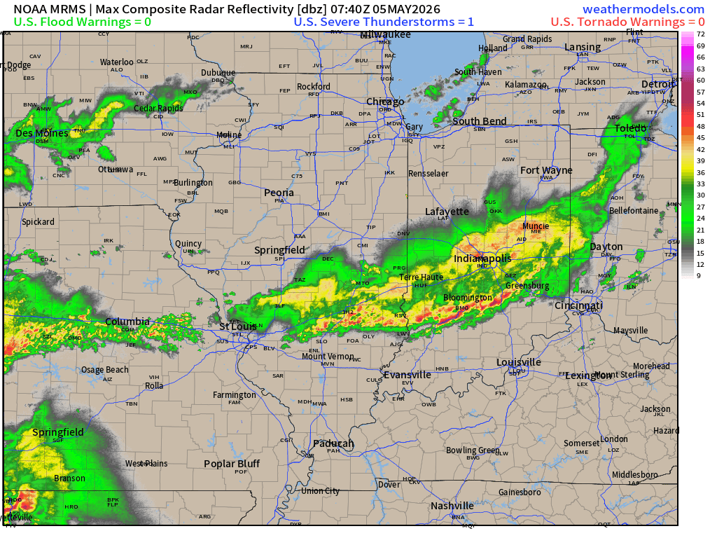
Here was the 4 AM radar animation.
You can see showers and thunderstorms moving towards our region.
All of this will push across the area later today and tonight.
.
.
A cold front will move into the area later today and pass through tonight. As it gets closer, dewpoints will increase and clouds will increase.
This front will help trigger showers and thunderstorms today and tonight.
The atmosphere may not become very unstable, which could limit how strong storms become. However, because the front will arrive during the warmest part of the day, it will still need to be watched.
A few storms could become strong, but the overall risk for severe weather appears low to marginal. Mainly across southeast Missouri and western Tennessee. Lower chances of severe weather as you travel into Kentucky and Illinois. I will monitor it, as always.
Widespread rain is expected today and tonight, with most areas receiving 0.80″ to 1.60″ of rain, and a few spots possibly getting more. If storms move over the same areas repeatedly, localized flooding could occur, but the overall flooding risk remains low.
Because of the clouds and rain, temperatures today will stay mostly in the 60s, which is much cooler than yesterday’s 80s. This will begin a cooler stretch of weather, with highs staying in the 60s through Wednesday. Overnight lows will drop into the 40s, which is also cooler than normal for this time of year.
Looking ahead, there is a small chance of rain Friday night into the weekend. A stronger weather system may bring better chances for rain late in the weekend and early next week.
Between these systems, temperatures should warm back up closer to normal, with highs returning to the 70s and possibly near 80° in southern areas this weekend.
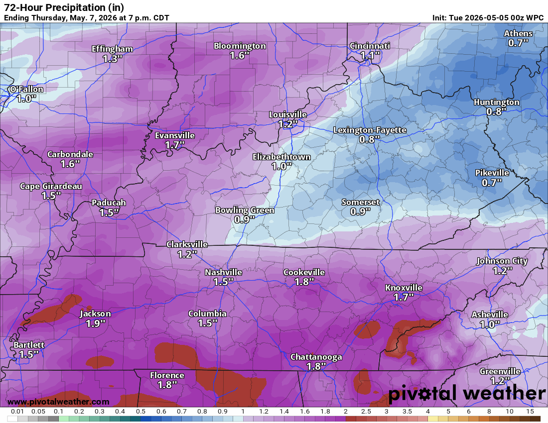
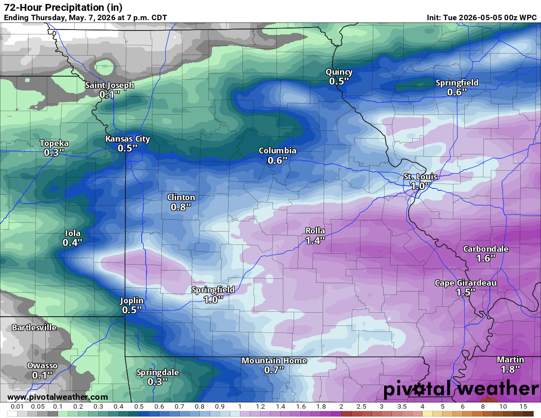
Here are the anticipated rainfall totals. As always, they will vary based on where thunderstorms occur.
Thunderstorms will enhance totals.
Double-click the image to enlarge it.
.
Looking ahead, there is a small chance of showers and thunderstorms on Friday afternoon into Friday night and a higher chance on Sunday and Monday.
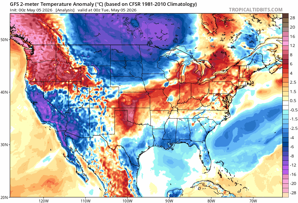
The charts show several waves of below normal temperatures into the middle of May.
A bit of a roller-coaster ride in the temperature department. Orange and red colors mean above-average temperatures.
You can see that in this animation. The blue and purple colors represent below-average temperatures.
Double-click on the animation to enlarge it.
.
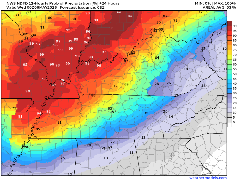
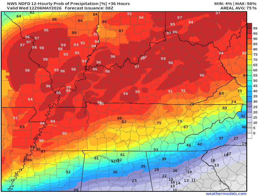
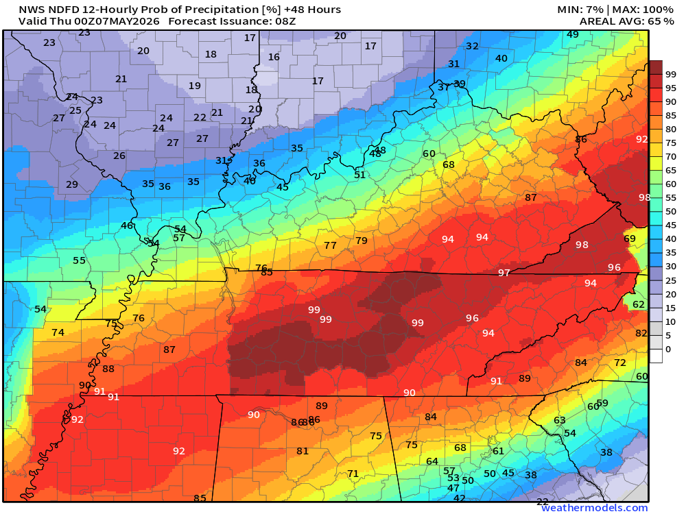
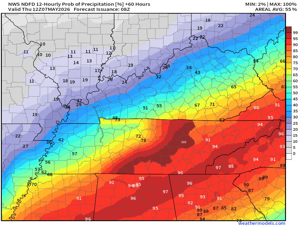
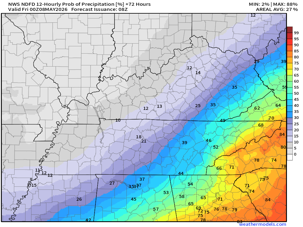
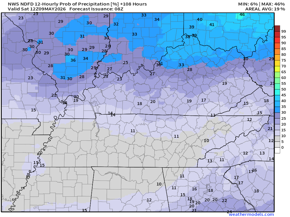
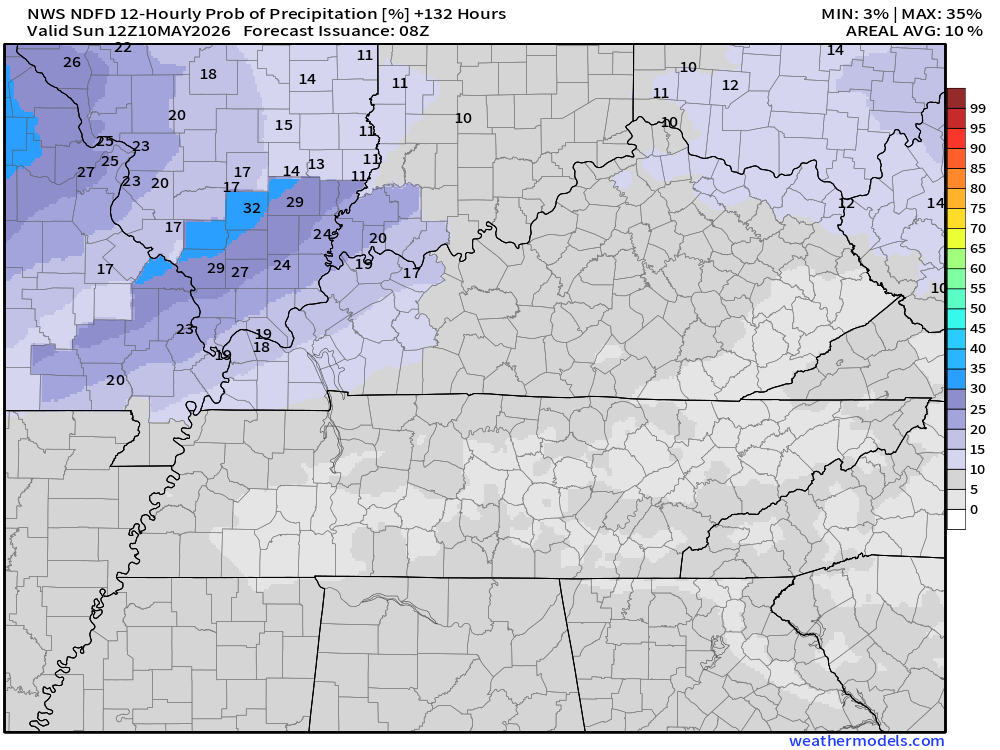
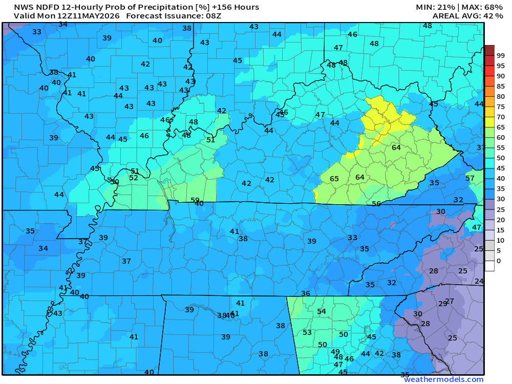
Let’s look at the rain probability maps. What is the % chance of rain?
.
7 AM Tuesday through 7 PM Tuesday.
Double-click maps to enlarge them.
.
7 PM Tuesday to 7 AM Wednesday
.
7 AM Wednesday through 7 PM Wednesday
.
7 PM Wednesday to 7 AM Thursday
.
7 AM Thursday to 7 PM Thursday
.
7 PM Friday to 7 AM Saturday
.
7 PM Saturday to 7 AM Sunday
.
7 AM Sunday to 7 PM Sunday

.
7 PM Sunday to 7 AM Monday

.
The timestamp (upper left) is in Zulu. 12z=7 am. 18z=1 pm. 00z=7 pm.
Green is rain. Yellow is moderate rain. Orange indicates locally heavy rain.
This model pops most of the storms east northeast of our region (on Thursday PM)
Double-click the animation to enlarge it.
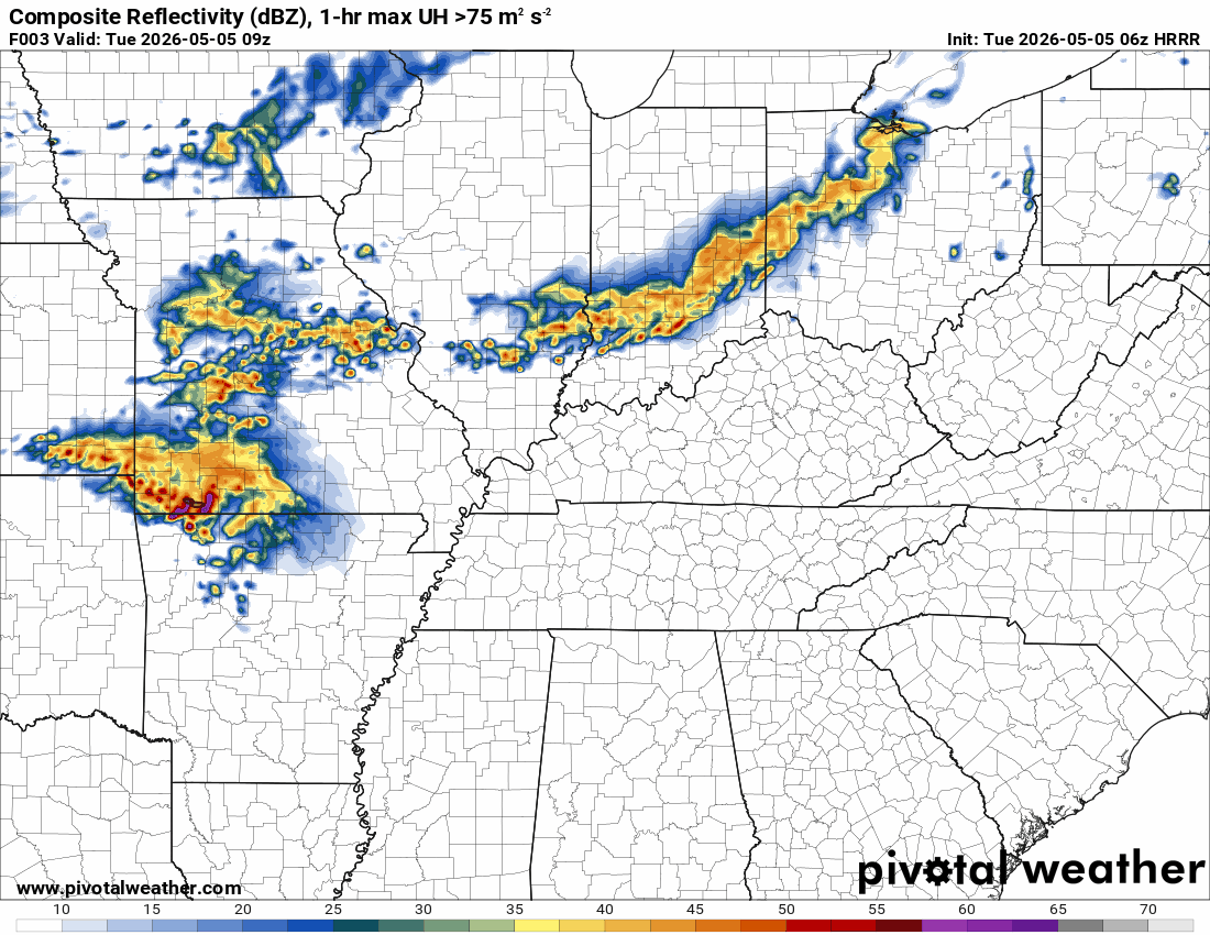
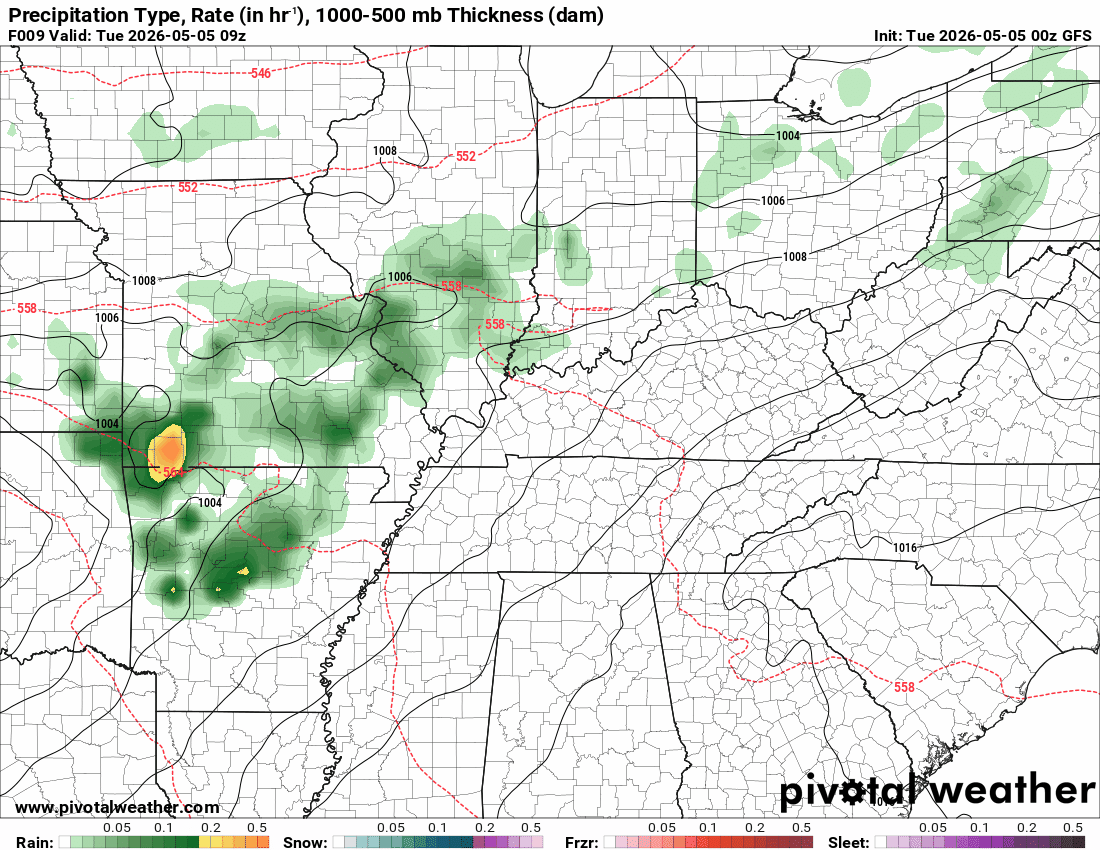
Hrrr Model
.
.
The timestamp (upper left) is in Zulu. 12z=7 am. 18z=1 pm. 00z=7 pm.
Green is rain. Yellow is moderate rain. Orange indicates locally heavy rain.
Double-click the animation to enlarge it.
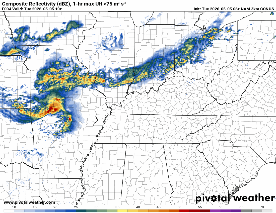
NAM 3K Model
.
The timestamp (upper left) is in Zulu. 12z=7 am. 18z=1 pm. 00z=7 pm.
Green is rain. Yellow is moderate rain. Orange indicates locally heavy rain.
Double-click the animation to enlarge it.
GFS Model
.
..
.
Click here if you would like to return to the top of the page.
.Average high temperatures for this time of the year are around 75 degrees.
Average low temperatures for this time of the year are around 52 degrees.
Average precipitation during this time period ranges from 1.00″ to 1.20″
Six to Ten Day Outlook.
Blue is below average. Red is above average. The no color zone represents equal chances.
Average highs for this time of the year are in the lower 60s. Average lows for this time of the year are in the lower 40s.

Green is above average precipitation. Yellow and brown favors below-average precipitation. Average precipitation for this time of the year is around one inch per week.

.

Average low temperatures for this time of the year are around 58 degrees.
Average precipitation during this time period ranges from 1.00″ to 1.30″
.
Eight to Fourteen Day Outlook.
Blue is below average. Red is above average. The no color zone represents equal chances.

Green is above average precipitation. Yellow and brown favors below average precipitation. Average precipitation for this time of the year is around one inch per week.

.
.
.
We have a new service to complement your www.weathertalk.com subscription. This does NOT replace www.weathertalk.com It is simply another tool for you to receive severe weather information.
.
https://weathercallservices.com/beau-dodson-weather


Want to receive the daily forecast/other products on your Beau Dodson Weather app?
Did you know you have four options in your www.weathertalk.com account
You will then receive these via your Beau Dodson Weather app.
Just log into your www.weathertalk.com account
Click the NOTIFICATION SETTINGS TAB
Then, turn them on (green) and off (red)
🌪️ Number 1 is the most important one. Severe alerts, tornado alerts, and so on.
Number 2 is the daily video, blog, livestream alerts, and severe weather Facebook threads on severe days or winter storm days.
Number 3 is the daily forecast. I send that out every day during the afternoon hours. It is the seven-day forecast, hazardous weather outlook, fire outlook, and more.
Number 4 is to receive the daily video, blog, and other content on NON-severe weather days (every day without severe threats in other words)
GREEN IS ON
RED IS OFF


Radars and Lightning Data
Interactive-city-view radars. Clickable watches and warnings.
https://wtalk.co/B3XHASFZ
Old legacy radar site (some of you like it better)
https://weatherobservatory.com/weather-radar.htm
If the radar is not updating then try another one. If a radar does not appear to be refreshing then hit Ctrl F5. You may also try restarting your browser.
Backup radar site in case the above one is not working.
https://weathertalk.com/morani
Regional Radar
https://imagery.weathertalk.com/prx/RadarLoop.mp4
** NEW ** Zoom radar with chaser tracking abilities!
ZoomRadar
If the radar is not working, then email me: Email me at beaudodson@usawx.com
.
We do have some sponsors! Check them out.
Roof damage from recent storms? Link – Click here
INTEGRITY ROOFING AND EXTERIORS!
⛈️ Roof or gutter damage from recent storms? Today’s weather is sponsored by Integrity Roofing. Check out their website at this link https://www.ourintegritymatters.com/

![]()
![]()
![]()
Make sure you have three to five ways of receiving your severe weather information.
Weather Talk is one of those ways! Now, I have another product for you and your family.

.
Want to add more products to your Beau Dodson Weather App?
Receive daily videos, weather blog updates on normal weather days and severe weather and winter storm days, your county by county weather forecast, and more!
Here is how to do add those additional products to your app notification settings!
Here is a video on how to update your Beau Dodson Weather payment.
The app is for subscribers. Subscribe at www.weathertalk.com/welcome then go to your app store and search for WeatherTalk
Subscribers, PLEASE USE THE APP. ATT and Verizon are not reliable during severe weather. They are delaying text messages.
The app is under WeatherTalk in the app store.

Apple users click here

Android users click here
.
Radars and Lightning Data
Interactive-city-view radars. Clickable watches and warnings.
https://wtalk.co/B3XHASFZ
Old legacy radar site (some of you like it better)
https://weatherobservatory.com/weather-radar.htm
If the radar is not updating then try another one. If a radar does not appear to be refreshing then hit Ctrl F5. You may also try restarting your browser.
Backup radar site in case the above one is not working.
https://weathertalk.com/morani
Regional Radar
https://imagery.weathertalk.com/prx/RadarLoop.mp4
** NEW ** Zoom radar with chaser tracking abilities!
ZoomRadar
Lightning Data (zoom in and out of your local area)
https://wtalk.co/WJ3SN5UZ
Not working? Email me at beaudodson@usawx.com
National map of weather watches and warnings. Click here.
Storm Prediction Center. Click here.
Weather Prediction Center. Click here.
.

Live lightning data: Click here.
Real time lightning data (another one) https://map.blitzortung.org/#5.02/37.95/-86.99
Our new Zoom radar with storm chases
.
.

Interactive GOES R satellite. Track clouds. Click here.
GOES 16 slider tool. Click here.
College of DuPage satellites. Click here
.

Here are the latest local river stage forecast numbers Click Here.
Here are the latest lake stage forecast numbers for Kentucky Lake and Lake Barkley Click Here.
.
.
Find Beau on Facebook! Click the banner.


 .
.