

.
I have some question-and-answer threads over on the Facebook page. Link to those threads CLICK HERE
Or email me at beaudodsonweather@gmail.com
.

🌪️ Seven-Day Tornado Outlook ⛈️
May 5th through May 11th
Current risk: There is currently no risk of tornadoes in the seven-day forecast.
Current confidence level: High confidence in the forecast.
Comment:
.

Seven-Day Hazardous Weather Outlook
1. Is lightning in the forecast? LOW CHANCE. We will have a low chance of lightning Wednesday through at least Friday.
2. Are severe thunderstorms in the forecast? NO.
3. Is flash flooding in the forecast? NO.
4. Will non-thunderstorm winds top 40 mph? NO.
5. Will temperatures rise above 90 degrees? NO.
6. Will the heat index rise above 100 degrees? NO.
.
A quick forecast glance. Your 48-hour forecast Graphics


.

.


Forecast discussion.
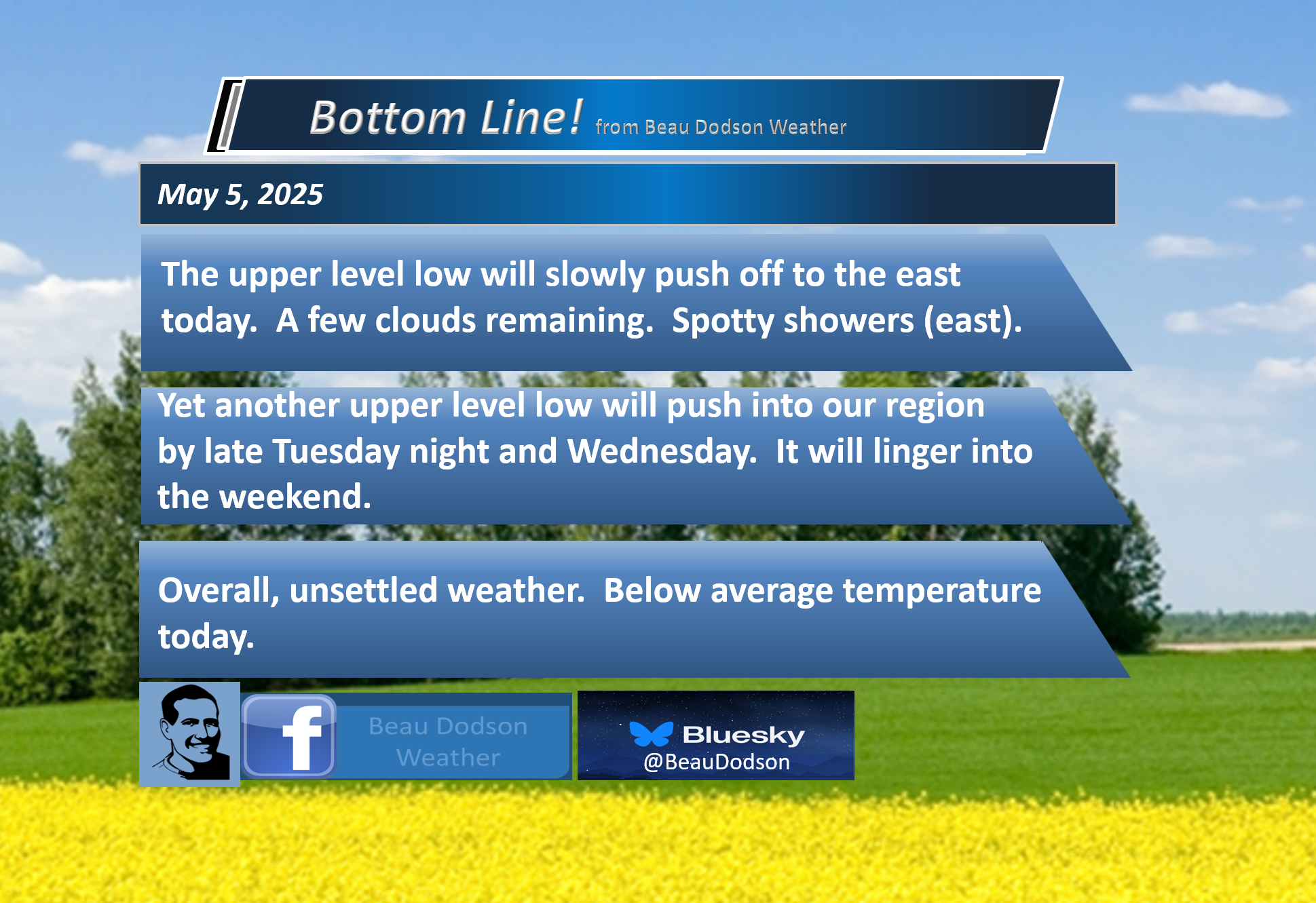
- Cool today. A few showers remain over our eastern counties.
- A slow warming trend this week.
- Another chance of showers Wednesday through Friday. For now, these appear to be low-end chances. Monitor updates.
- Temperatures Tuesday through Sunday will be near to below average, overall.
.

.
It isn’t very often in May that the weatherman can breathe easily. This is our peak time of the year for severe thunderstorms and tornadoes.
With this cool air, however, we can all relax. We aren’t going to have severe thunderstorms and tornadoes with this pattern.
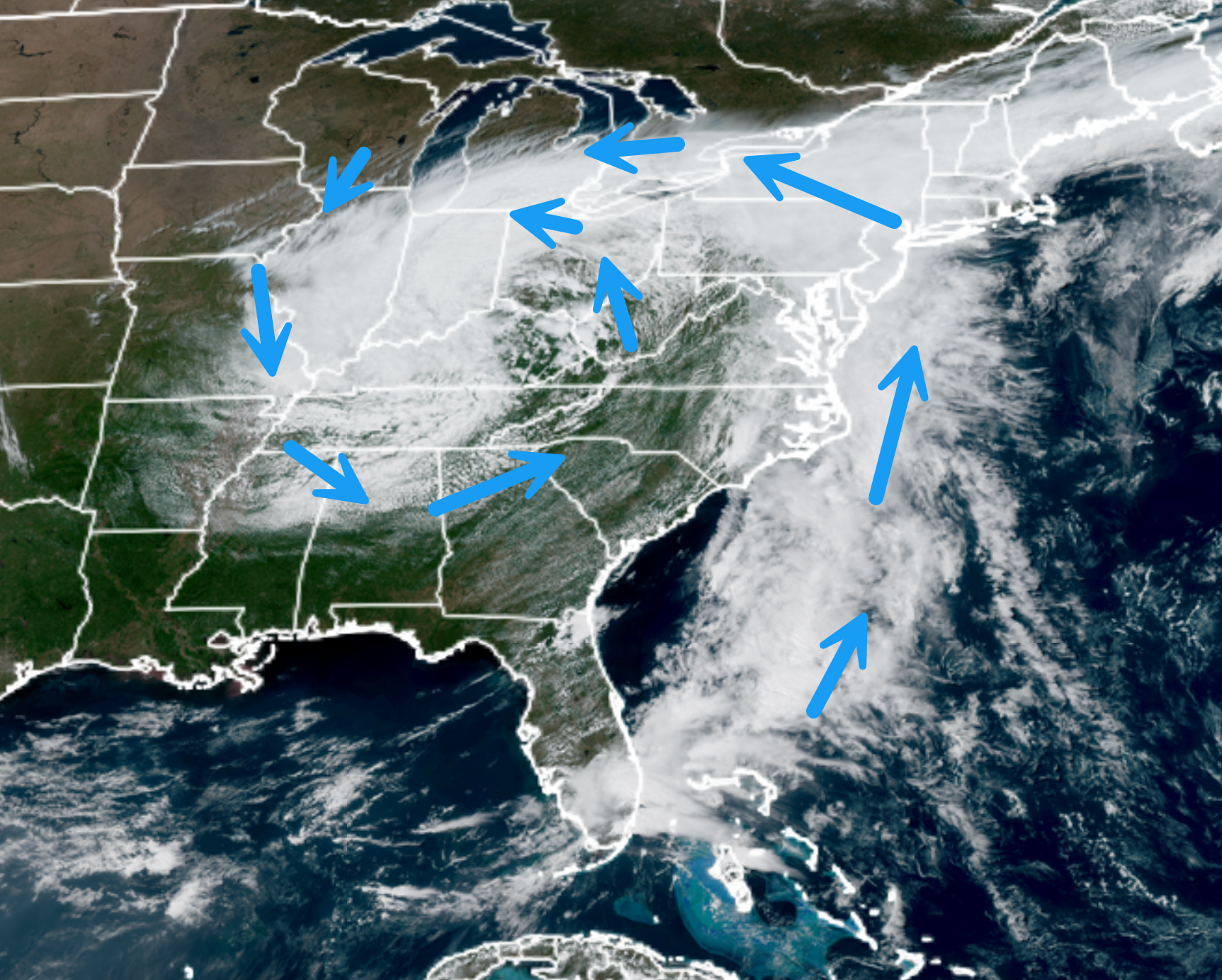
The weekend was dominated by a large upper-level cut-off low. These cut-off lows are removed from the jet stream. They tend to move slowly or not at all.
They bring daily clouds, cool temperatures, and scattered showers. That summed up the weekend for most locations.
You can see it on the visible satellite. Spinning over us all weekend. Rotating counter-clockwise.
.
That system will slowly move off to the east today.
We will still have some clouds in the region. There could still be some spotty light showers across mainly southern Illinois and western Kentucky.
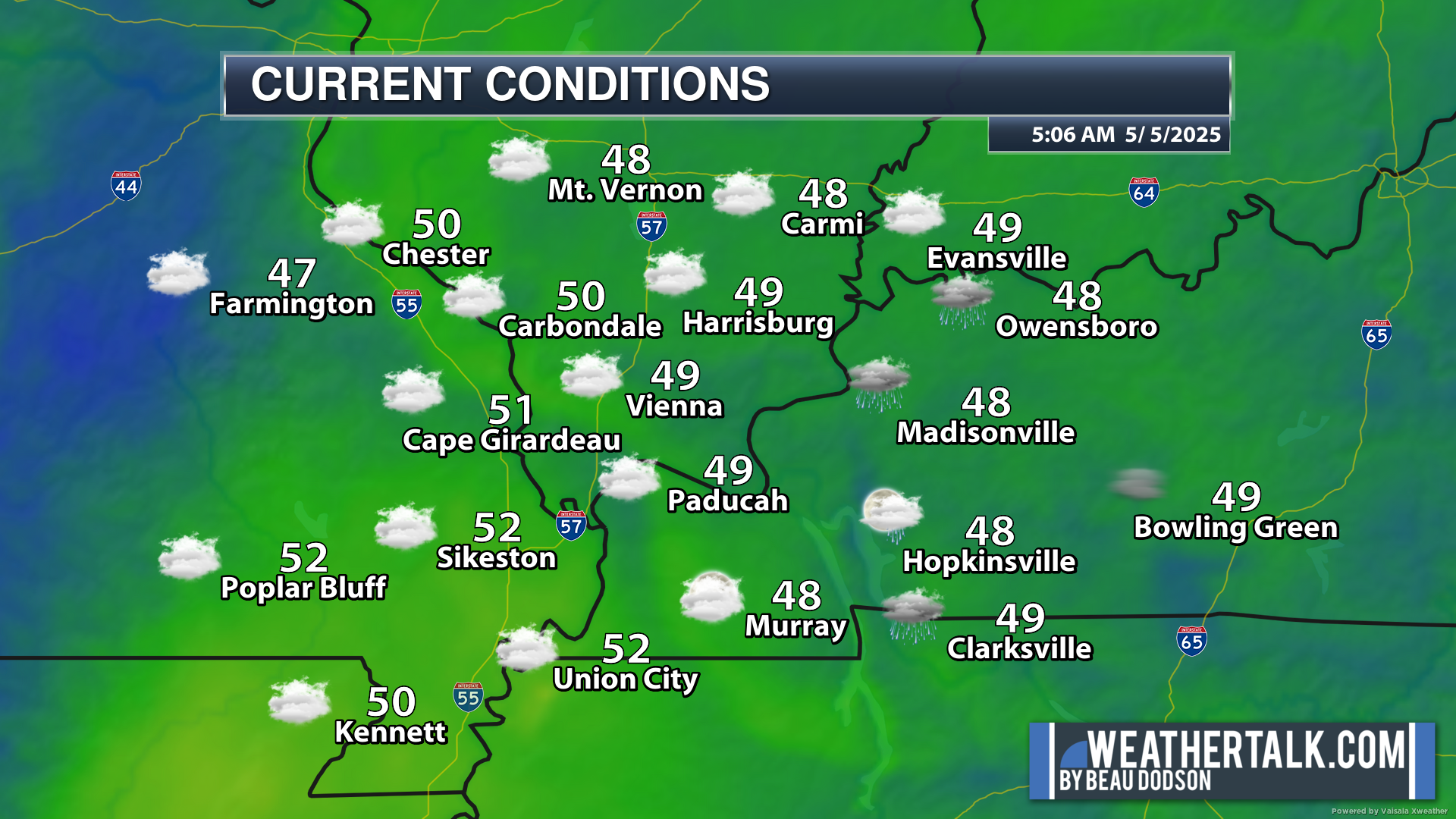
It is cool this morning. Check out the 6 am temperatures. Some locations are in the forties. For me, that is a bit chilly. However, I did sleep with my windows open!
.
Temperatures today will rise into the sixties across most of the area. Perhaps a few spots hit the 70 mark (where there is a bit more sunshine).
Temperatures will moderate into the 70s tomorrow through Friday.
Another upper-level low will find itself cut off over the lower Mississippi Valley this week. This will make for fresh forecast headaches.
A lot of meteorologists call these upper-level lows a weatherman’s woe. They are tricky to forecast. This last one was certainly a pain. Remember, at one point, the entire weekend was dry. Then, with each passing day, we had to adjust rain chances upward.
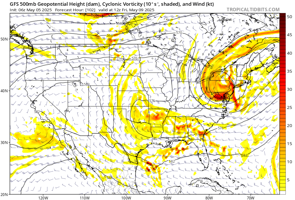
Here is the weekend cut-off on the GFS 500 MB vorticity map.
You can see it over our region.
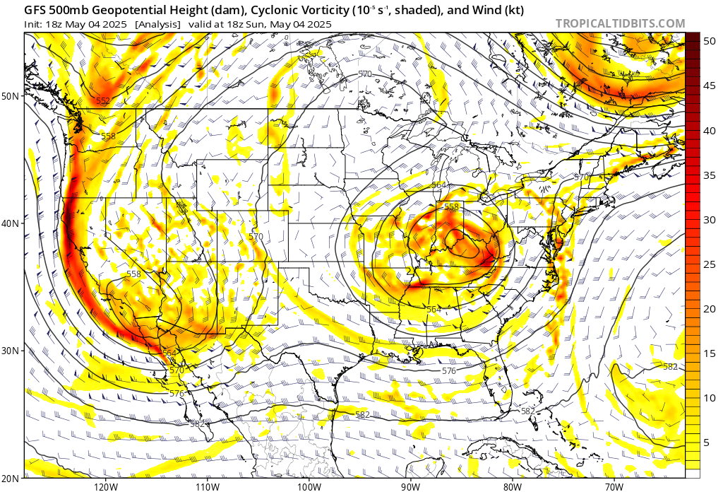
Here is what the next one looks like. Not quite as impressive as the first one.
You can also still see the first one moving off to the northeast (over New England and the northeast).
.
This next one will be centered over Arkansas.
From 24 hours ago, the chances of rain have come down just a tad.
They are looking more in line with 20% to 40% chances from Tuesday night through Friday. Maybe even Saturday.
Peak chances are currently forecast for Wednesday and Thursday.
It won’t rain all the time. It won’t rain everywhere every day. But, there will be clouds in our region this week and some scattered showers. An isolated rumble of thunder, perhaps, although lightning chances appear relatively small.
Again, no severe weather concerns.
If you have outdoor plans this week, then I would monitor updates.
.

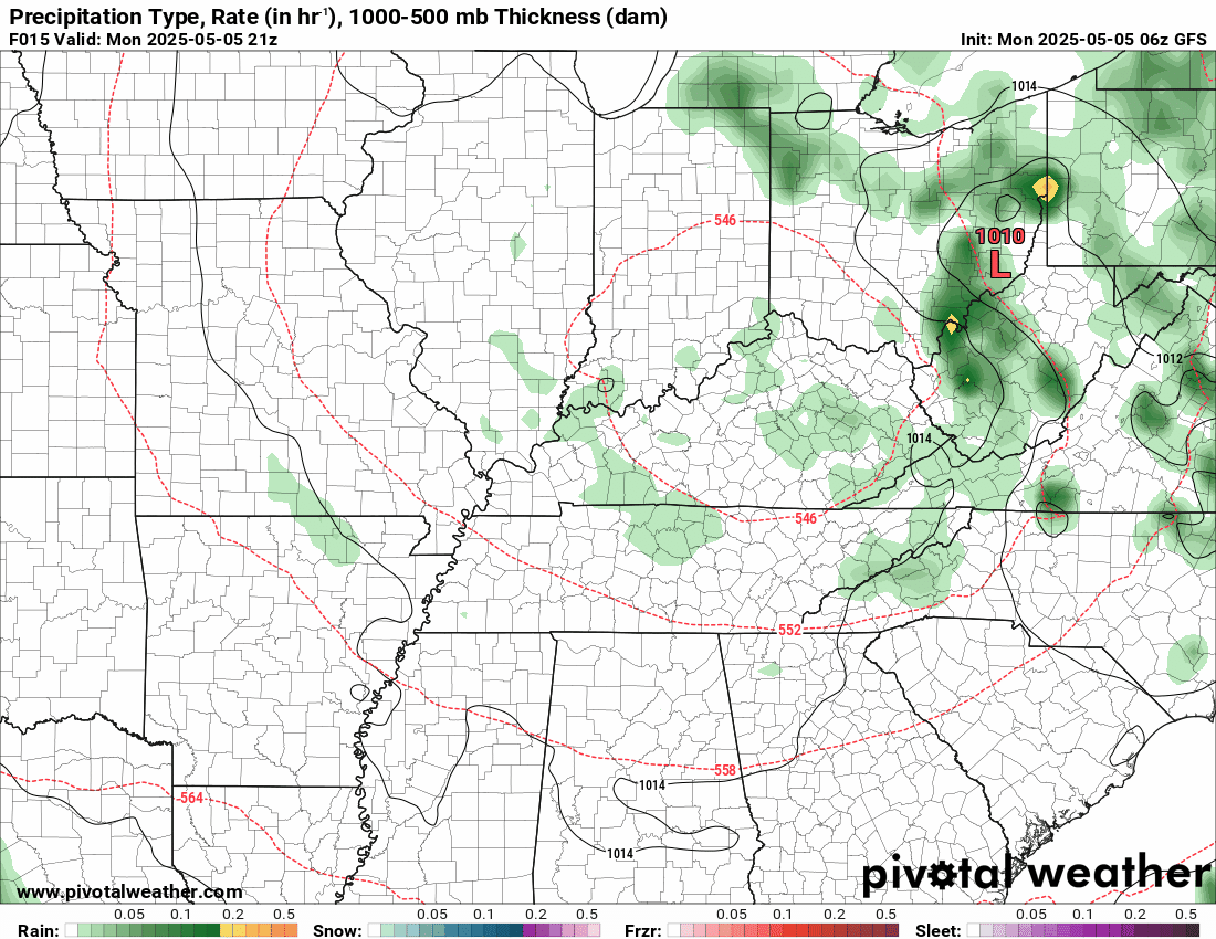
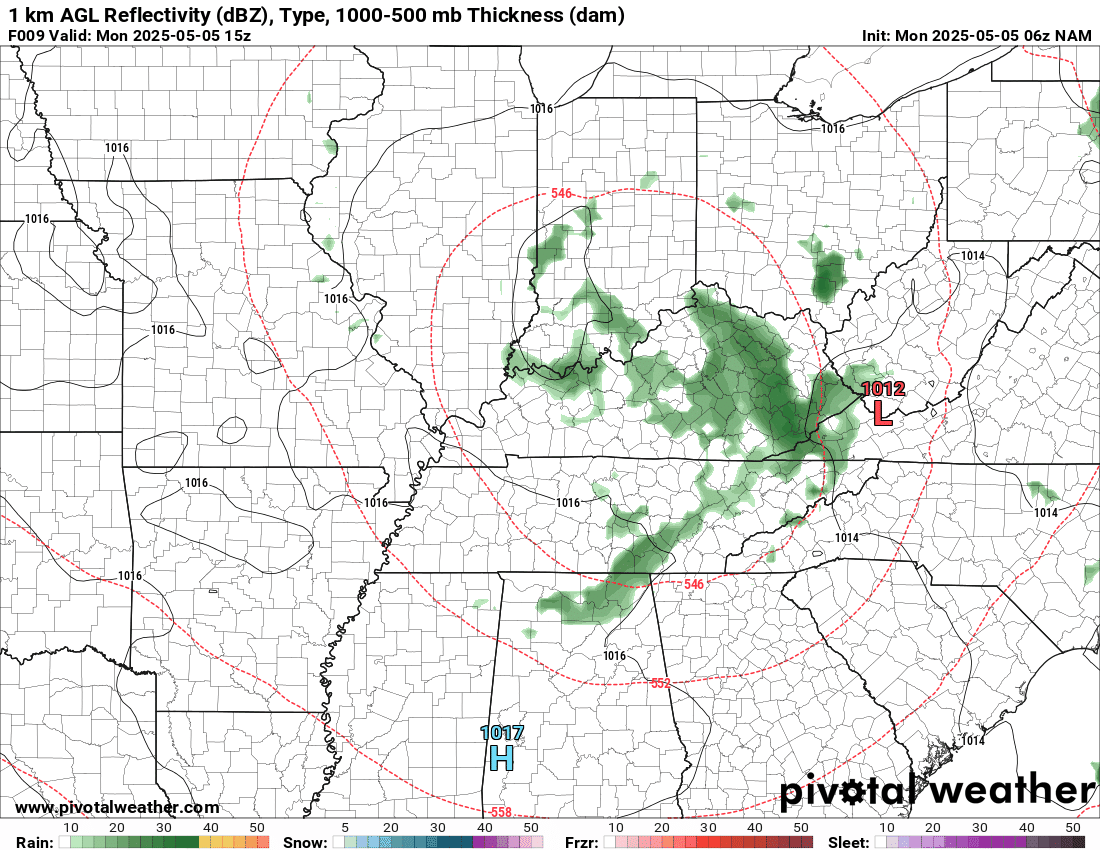
The timestamp (upper left) is in Zulu. 12z=7 am. 18z=1 pm. 00z=7 pm.
Double-click the animation to enlarge it.
GFS model.
.
Here is the NAM model.
.
.
.
Click here if you would like to return to the top of the page.
.Average high temperatures for this time of the year are around 73 degrees.
Average low temperatures for this time of the year are around 52 degrees.
Average precipitation during this time period ranges from 1.00″ to 1.40″
Six to Ten Day Outlook.
Blue is below average. Red is above average. The no color zone represents equal chances.
Average highs for this time of the year are in the lower 60s. Average lows for this time of the year are in the lower 40s.

Green is above average precipitation. Yellow and brown favors below average precipitation. Average precipitation for this time of the year is around one inch per week.

.

Average low temperatures for this time of the year are around 55 degrees.
Average precipitation during this time period ranges from 1.20″ to 1.50″
.
Eight to Fourteen Day Outlook.
Blue is below average. Red is above average. The no color zone represents equal chances.

Green is above average precipitation. Yellow and brown favors below average precipitation. Average precipitation for this time of the year is around one inch per week.

.
.
.
We have a new service to complement your www.weathertalk.com subscription. This does NOT replace www.weathertalk.com It is simply another tool for you to receive severe weather information.
.


.

Radars and Lightning Data
Interactive-city-view radars. Clickable watches and warnings.
https://wtalk.co/B3XHASFZ
Old legacy radar site (some of you like it better)
https://weatherobservatory.com/weather-radar.htm
If the radar is not updating then try another one. If a radar does not appear to be refreshing then hit Ctrl F5. You may also try restarting your browser.
Backup radar site in case the above one is not working.
https://weathertalk.com/morani
Regional Radar
https://imagery.weathertalk.com/prx/RadarLoop.mp4
** NEW ** Zoom radar with chaser tracking abilities!
ZoomRadar
If the radar is not working, then email me: Email me at beaudodson@usawx.com
.
We do have some sponsors! Check them out.
Roof damage from recent storms? Link – Click here
INTEGRITY ROOFING AND EXTERIORS!
⛈️ Roof or gutter damage from recent storms? Today’s weather is sponsored by Integrity Roofing. Check out their website at this link https://www.ourintegritymatters.com/

![]()
![]()
![]()
Make sure you have three to five ways of receiving your severe weather information.
Weather Talk is one of those ways! Now, I have another product for you and your family.

.
Want to add more products to your Beau Dodson Weather App?
Receive daily videos, weather blog updates on normal weather days and severe weather and winter storm days, your county by county weather forecast, and more!
Here is how to do add those additional products to your app notification settings!
Here is a video on how to update your Beau Dodson Weather payment.
The app is for subscribers. Subscribe at www.weathertalk.com/welcome then go to your app store and search for WeatherTalk
Subscribers, PLEASE USE THE APP. ATT and Verizon are not reliable during severe weather. They are delaying text messages.
The app is under WeatherTalk in the app store.

Apple users click here

Android users click here
.
Radars and Lightning Data
Interactive-city-view radars. Clickable watches and warnings.
https://wtalk.co/B3XHASFZ
Old legacy radar site (some of you like it better)
https://weatherobservatory.com/weather-radar.htm
If the radar is not updating then try another one. If a radar does not appear to be refreshing then hit Ctrl F5. You may also try restarting your browser.
Backup radar site in case the above one is not working.
https://weathertalk.com/morani
Regional Radar
https://imagery.weathertalk.com/prx/RadarLoop.mp4
** NEW ** Zoom radar with chaser tracking abilities!
ZoomRadar
Lightning Data (zoom in and out of your local area)
https://wtalk.co/WJ3SN5UZ
Not working? Email me at beaudodson@usawx.com
National map of weather watches and warnings. Click here.
Storm Prediction Center. Click here.
Weather Prediction Center. Click here.
.

Live lightning data: Click here.
Real time lightning data (another one) https://map.blitzortung.org/#5.02/37.95/-86.99
Our new Zoom radar with storm chases
.
.

Interactive GOES R satellite. Track clouds. Click here.
GOES 16 slider tool. Click here.
College of DuPage satellites. Click here
.

Here are the latest local river stage forecast numbers Click Here.
Here are the latest lake stage forecast numbers for Kentucky Lake and Lake Barkley Click Here.
.
.
Find Beau on Facebook! Click the banner.


 .
.