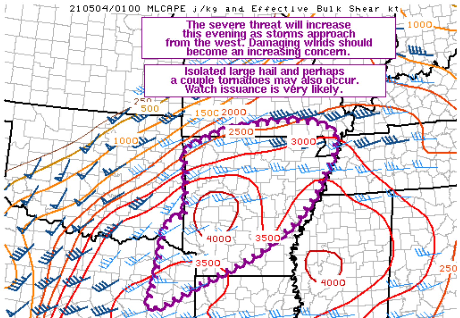
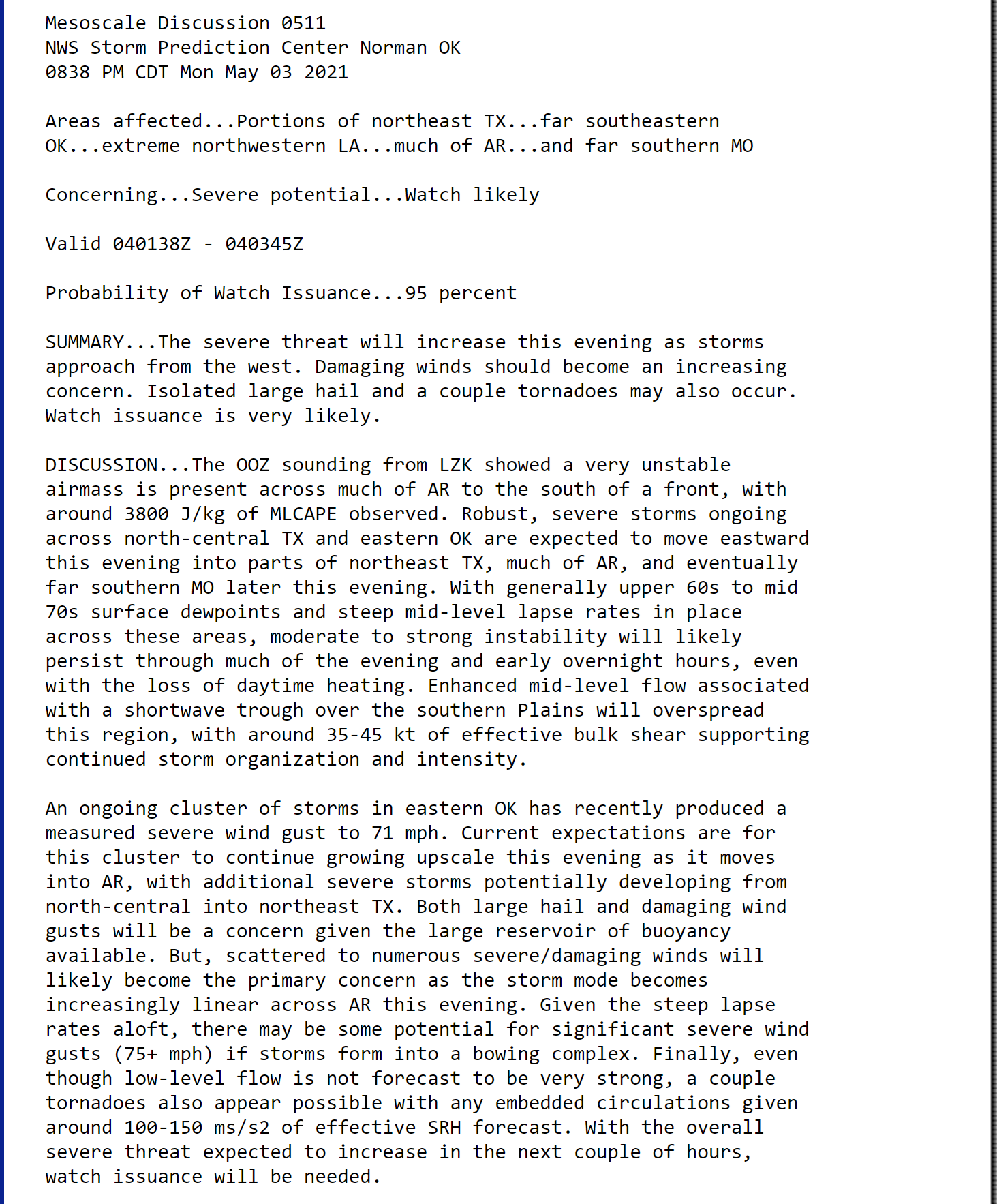
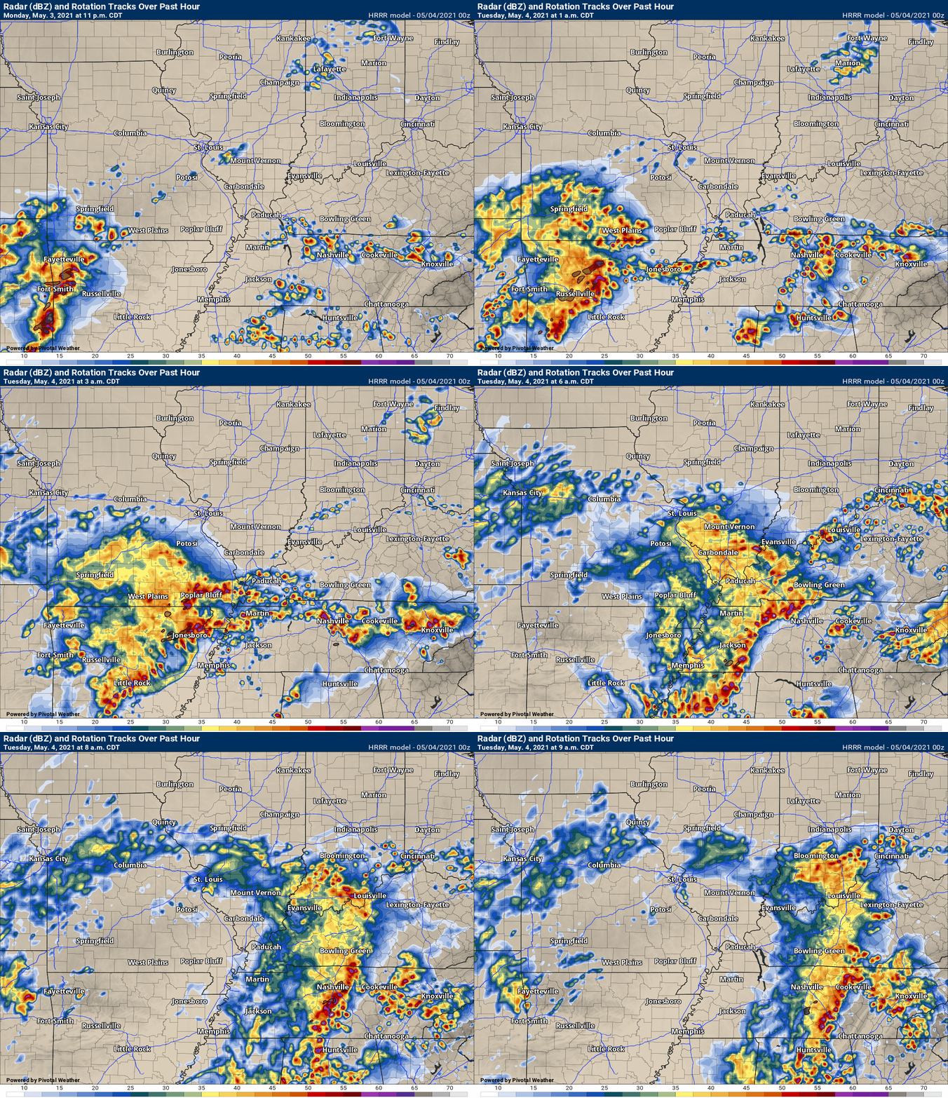
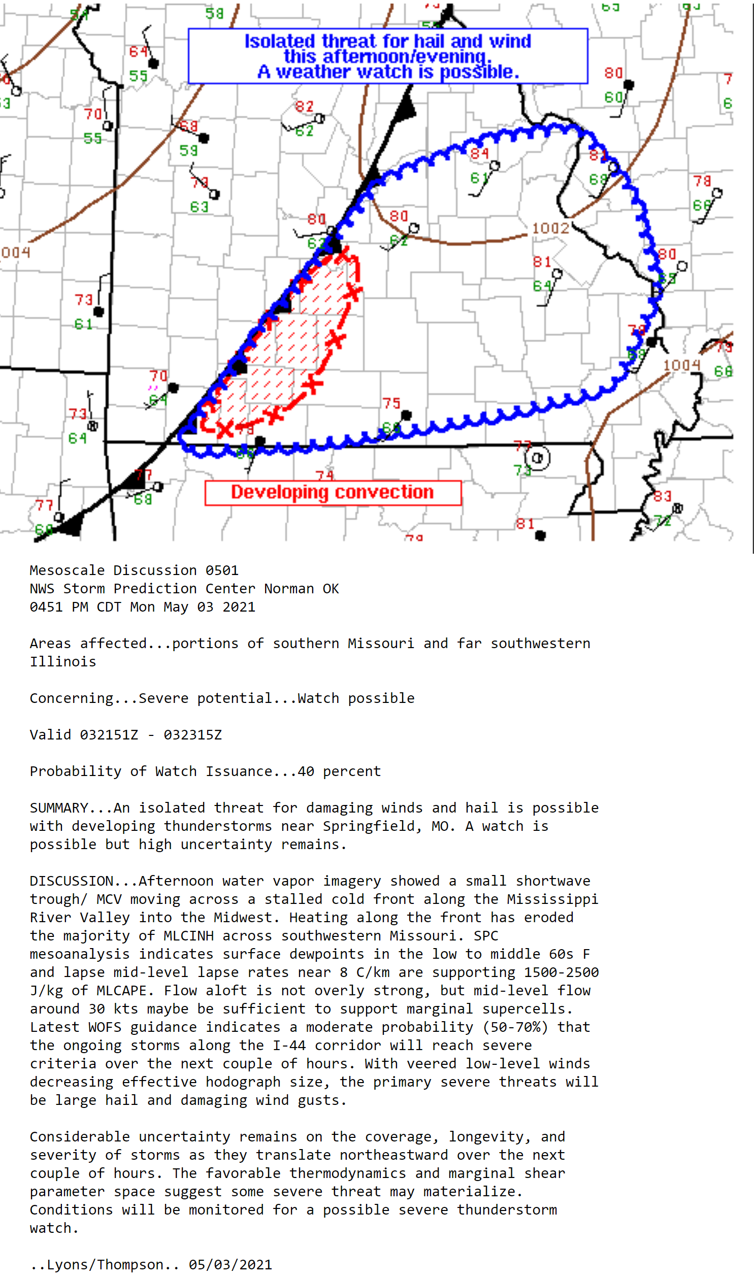
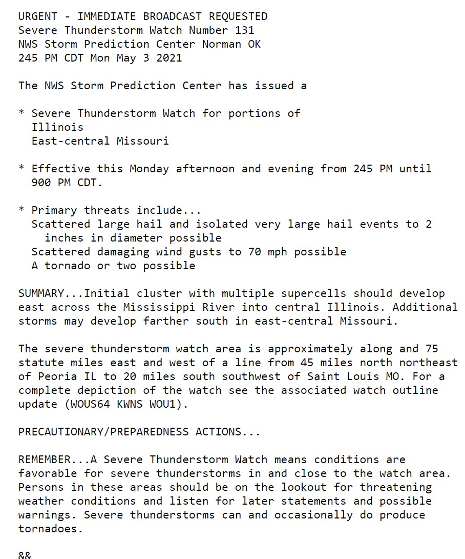
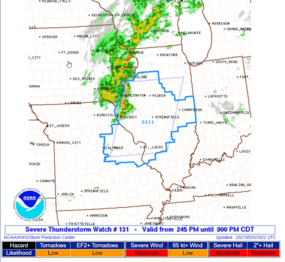
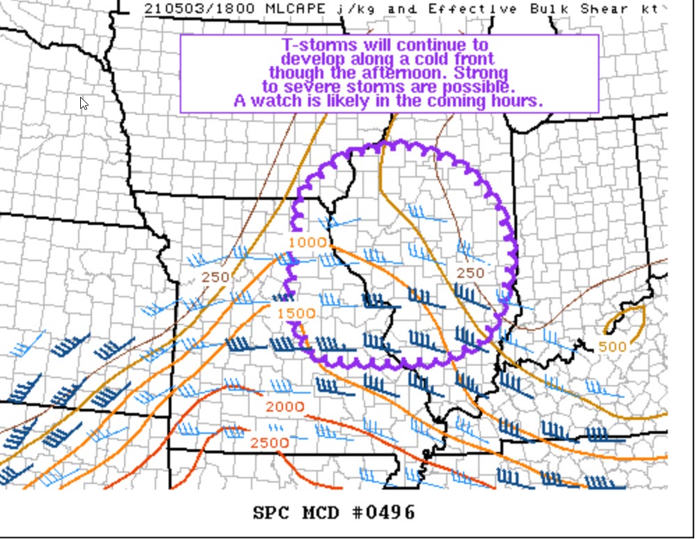
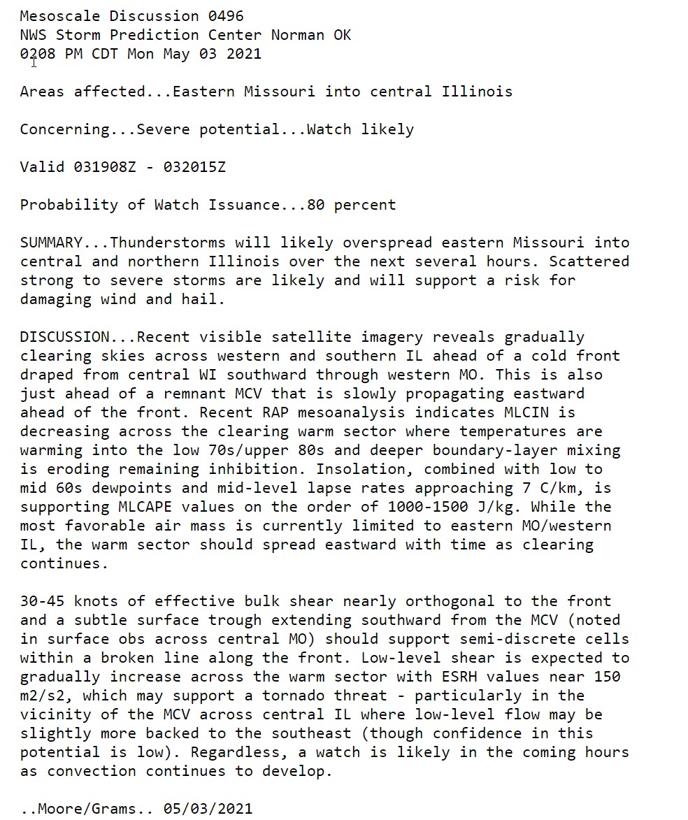
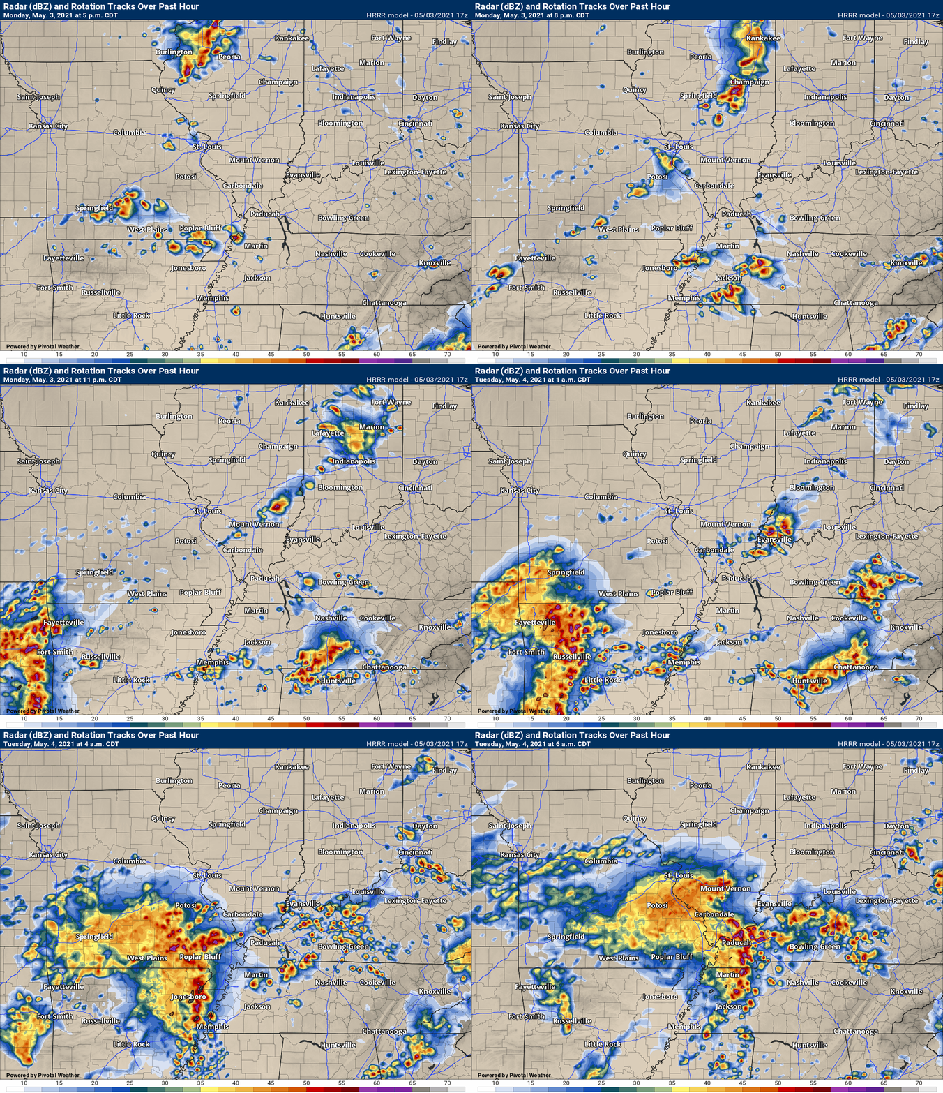
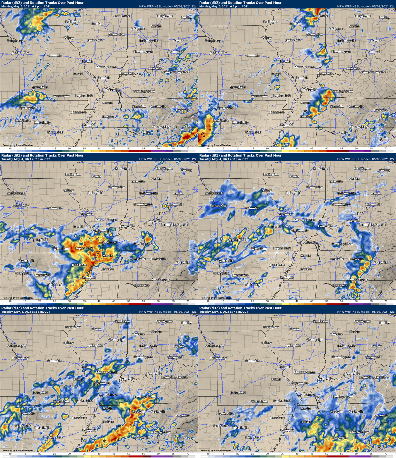
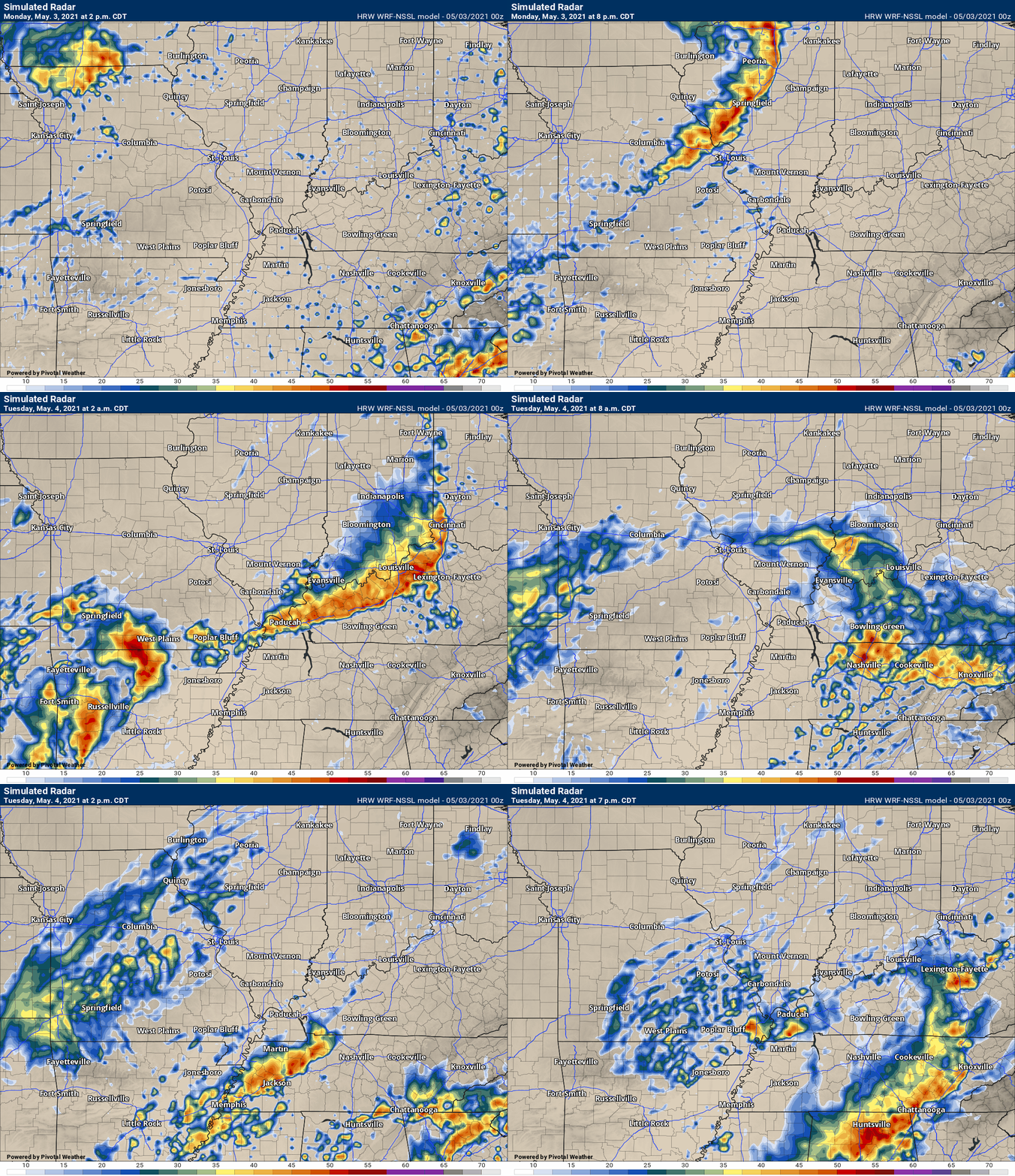
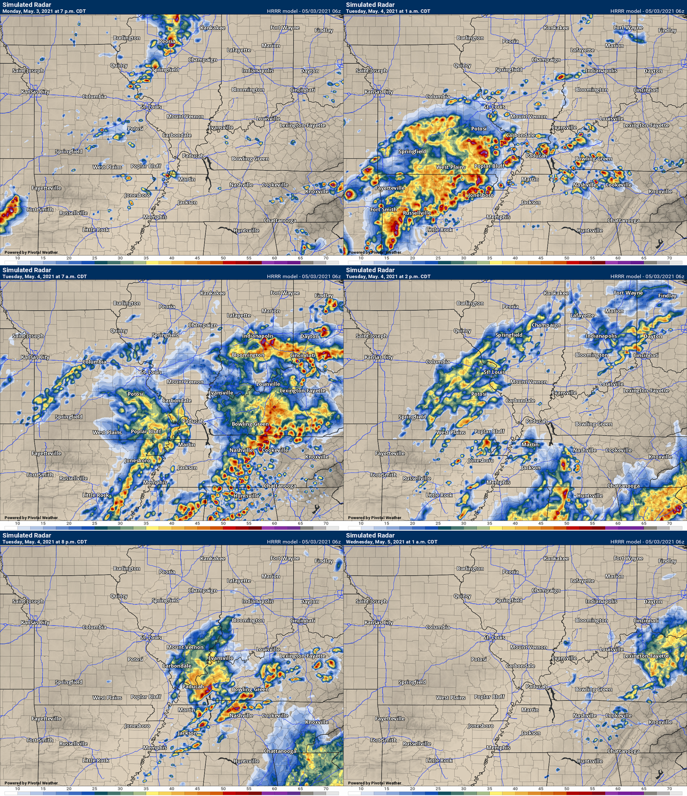
The latest update will be posted here at the top of Beau’s severe weather blog. I may delete old posts if it helps speed up the page.
Click on the words below to subscribe
.
May 3rd and 4th event.
Concerns:
Thunderstorms could become severe, especially late Monday night into early Tuesday morning. Another round late Tuesday morning and afternoon.
A lower chance of severe storms before that time.
Make sure your Beau Dodson Weather app is working.
.
Key Points
- A medium confidence forecast because of a CAP that could prevent storms from forming Monday afternoon into Tuesday morning.
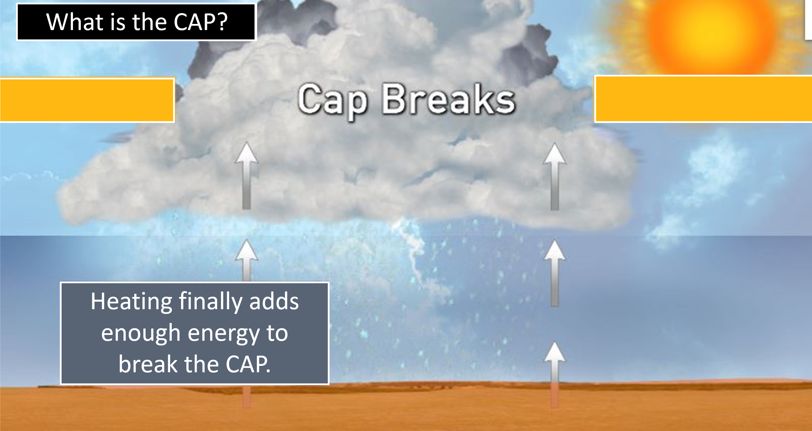
- It does now appear the CAP will break and storms will form.
- If thunderstorms do form then damaging wind and large hail will likely occur. An isolated tornado risk, as well.
- Thunderstorms will also produce torrential rain. Lightning, of course.
- It appears the greatest risk of storms may hold off until late Monday night. Storms could form before then, but the chances appear higher late Monday night into Tuesday morning.
- I added the chance of severe thunderstorms into Tuesday afternoon.
- Have your Beau Dodson Weather app on. Check it. Make sure you have not logged out of the app.
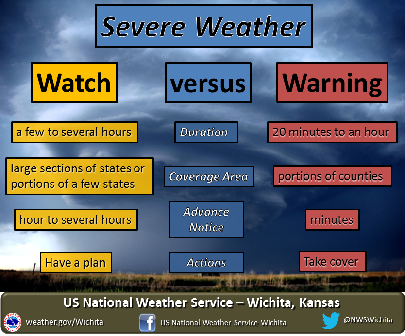
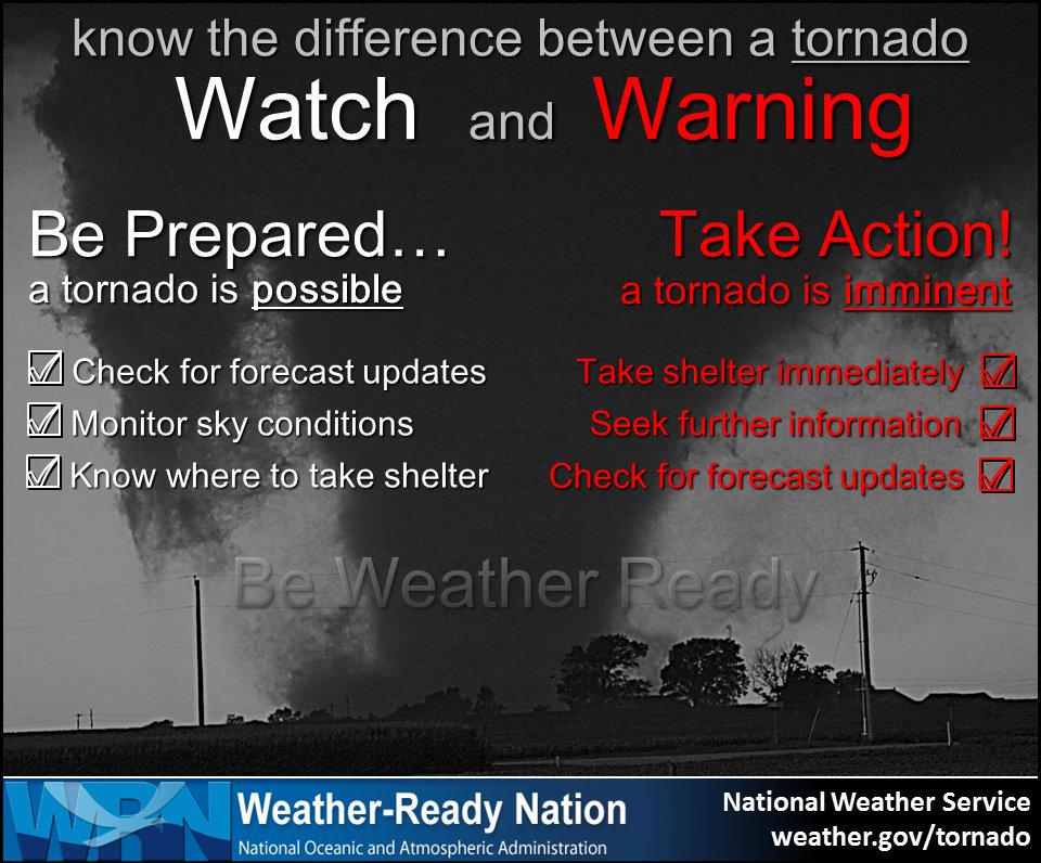
- Remember, a watch means to monitor updates. A warning means to seek shelter. A warning is a higher threat.
.
Call to action.
Monitor updated weather forecasts.
Have a safety plan.
Make sure you are using the Beau Dodson Weather Talk app. Download it from the app store. It is under Weather Talk.
The app is for subscribers (please log into your account and make sure your payment has been updated. We have a large number of declined cards and PayPal payments.
Subscribe at www.weathertalk.com/welcome then go to your app store and search for WeatherTalk.
Apple users click here. Android users click here .
.
6:15 PM
Overall, the threat of severe weather appears low. The atmosphere is unstable across the Missouri Bootheel and then along the KY/TN border.
I am monitoring thunderstorms that are moving through this area.
For now, they are below severe levels.
.
3:30 PM
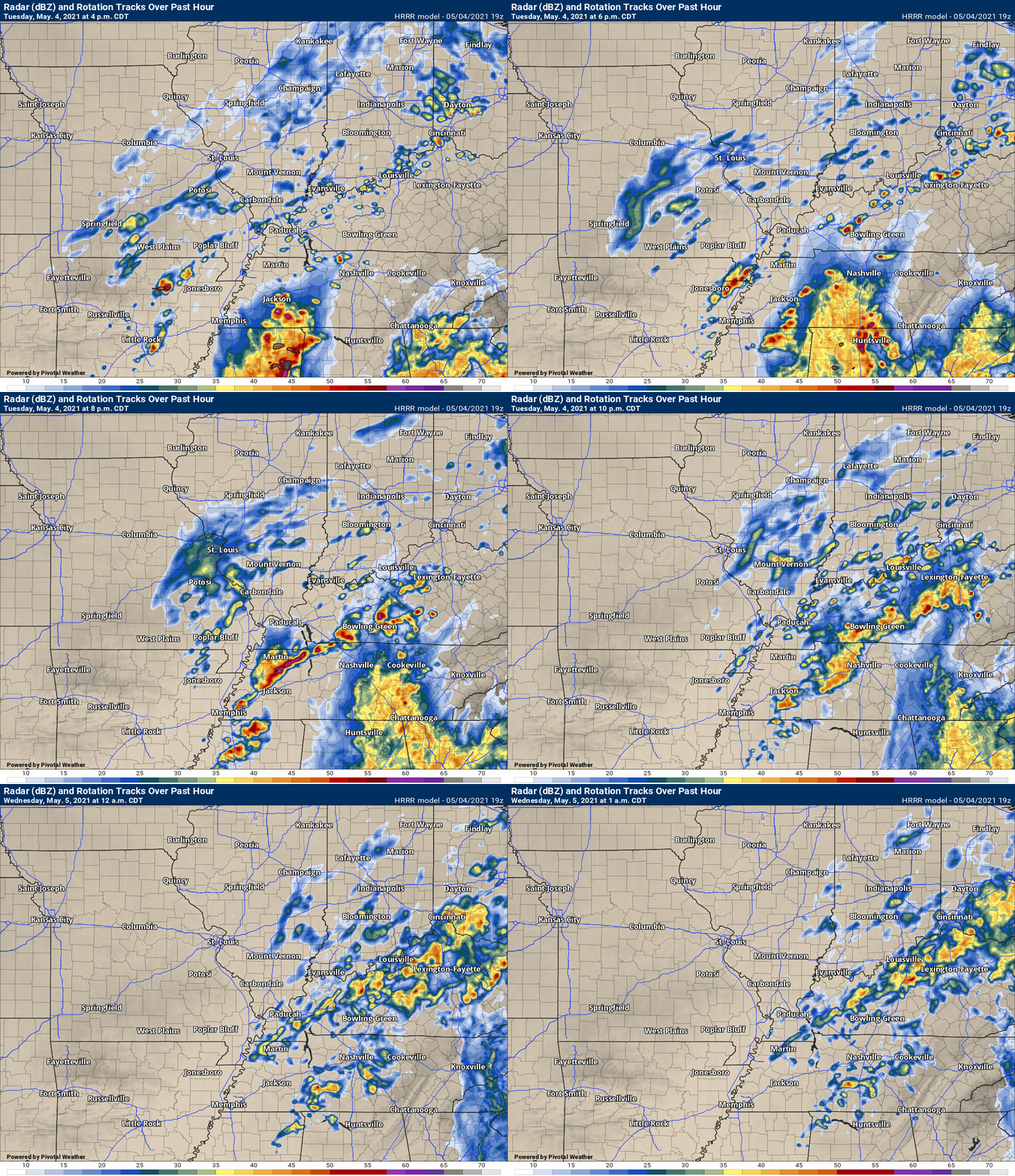
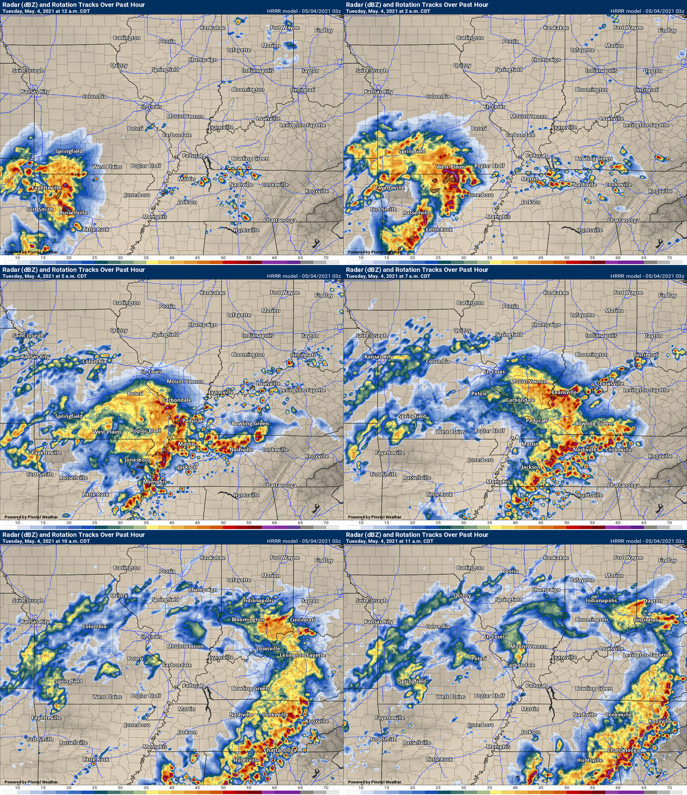
Future-cast radar. I am waiting for new storms to develop. The front is draped across the Missouri Bootheel into Kentucky and Tennessee. Storms should redevelop along the front over the next few hours.
A few of those storms could be severe with high wind and hail. This is how the Hrrr model is forecasting storms to form.
.
1:25 PM
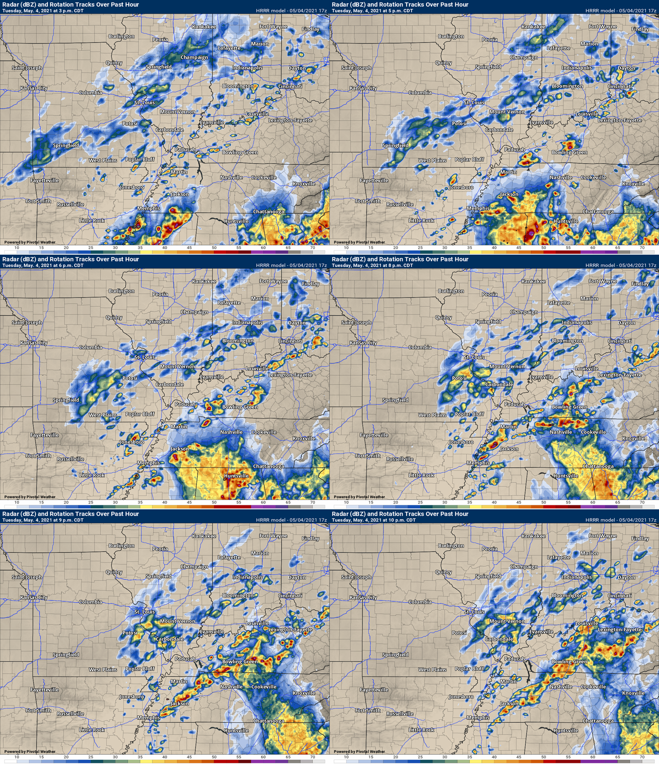
More storms will likely develop this afternoon. Some could be severe with high wind and hail.
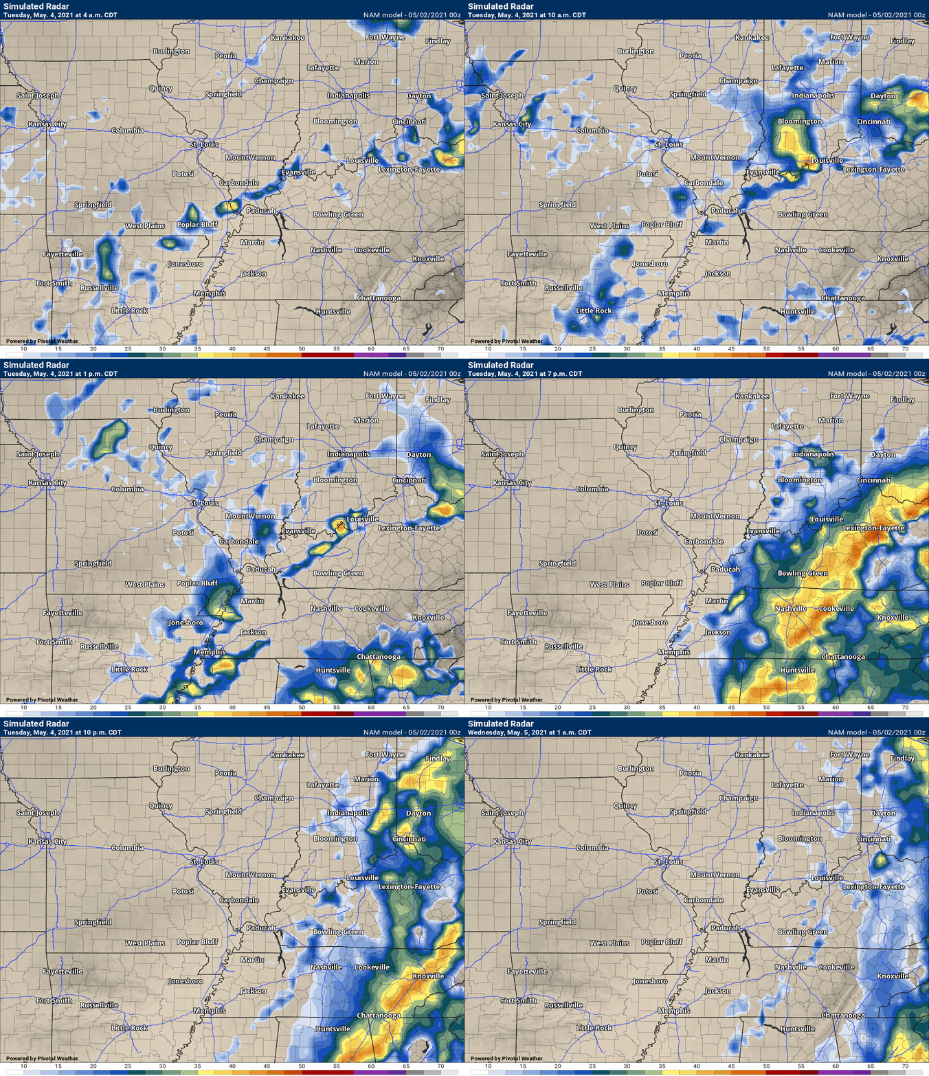
Future-cast radar. What radar MIGHT look like over the coming hours.
.
10:30 AM Update
There is quite a bit of damage across southeast Missouri and western Kentucky. Northwest Tennessee, as well. It was a stormy night for many.
The atmosphere may be able to recharge later today. That would help produce additional thunderstorms.
The main threat will be damaging wind.
There are questions about ongoing clouds. That could help the atmosphere stay a bit more stable. Additional severe weather chances aren’t a slam dunk forecast.
We will need to monitor 2 PM through 9 PM.
The risk is a bit higher across the Missouri Bootheel, western Kentucky, and northwest Tennessee.
Monitor updates.
.
5:40 AM
The threat of severe weather has ended, for now.
Additional severe storms will be possible this afternoon and evening. Mainly across western Kentucky and Tennessee.
.
5:18 AM
Radar shows the strongest area of rotation near Kirmansville, KY. This area of rotation is moving E and slightly NE at 50 mph.
The storm will move into northeast Christian County and into southern Muhlenberg/northern Todd Counties shortly.
Those in the path of this storm should seek shelter until the storm passes.
Radars and Lightning Data
Interactive local city-view radars. Clickable watches and warnings.
https://wtalk.co/B3XHASFZ
Backup radar site in case the above one is not working.
https://weathertalk.com/morani
Regional Radar
*NEW* Zoom interactive radar (with storm chaser streams)
https://wtalk.co/AVWG7GM7
Real time lightning tracker system two.
https://map.blitzortung.org/#5.02/37.95/-86.99
Lightning Data (zoom in and out of your local area)
https://wtalk.co/WJ3SN5UZ
5:15 AM
Tornado Warning [tornado: RADAR INDICATED, hail: <.75 IN] for Christian, Muhlenberg, Todd [KY] till 6:00 AM CDT …AT 514 AM CDT, A SEVERE THUNDERSTORM CAPABLE OF PRODUCING A TORNADO WAS LOCATED 8 MILES SOUTHEAST OF CROFTON, OR 12 MILES NORTHEAST OF HOPKINSVILLE, MOVING EAST AT 50 MPH.
.
5:13 AM
Intense thunderstorms continue east of LBL. These storms will move out of my forecast area over the coming hour.
4:45 AM
.
4:33 AM
Livingston, Crittenden, Webster, Hopkins, and Caldwell Counties.
A line of thunderstorms is moving through and into your counties. Some of these storms have a history of producing 50 to 60 mph wind gusts. Some wind damage will be possible with the heaviest storm cells.
Nickel size hail and heavy rain will also occur with these thunderstorms.
Storms are moving east at 50 mph.
Be weather aware as these storms move through the area.
4:29 AM
Very strong winds on radar in SE Calloway County. Moving into LBL and eventually Trigg County. Winds above 60 mph are possible.
.
4:20 AM
Henry and southeast Calloway County. Trigg County.
Another area of rotation was located south of Hazel, KY. This storm is moving E NE at 50 mph.
This is a different area of rotation than the Murray, KY storm. Seek shelter until the storm passes.
Seek shelter until this storm passes.
Interactive local city-view radars. Clickable watches and warnings.
https://wtalk.co/B3XHASFZ
.
4:16 AM
4:10 AM
Lyon, Trigg, Caldwell, and Christian Counties.
A line of severe thunderstorms is approaching from the west. The storms are moving east at 50 mph.
Some of the storms could produce wind damage over the coming hour. Short-lived tornadoes are also possible. There has been some wind damage with these thunderstorms.
Be weather aware as these storms move through the area.
Interactive local city-view radars. Clickable watches and warnings.
https://wtalk.co/B3XHASFZ
.
4:06 AM
Graves, Marshall, and Calloway Counties
Radar shows another area of rotation just east of Mayfield, Kentucky, moving E NE at 50 mph. This storm could produced short-lived tornadoes. Seek shelter until the storms pass.
Be weather aware as these storms move through the area.
Interactive local city-view radars. Clickable watches and warnings.
https://wtalk.co/B3XHASFZ
.
4 AM
BULLETIN - EAS ACTIVATION REQUESTED
TORNADO WARNING
NATIONAL WEATHER SERVICE PADUCAH KY
359 AM CDT TUE MAY 4 2021

THE NATIONAL WEATHER SERVICE IN PADUCAH HAS ISSUED A

* TORNADO WARNING FOR...
  CALLOWAY COUNTY IN WESTERN KENTUCKY...
  SOUTHEASTERN GRAVES COUNTY IN WESTERN KENTUCKY...

* UNTIL 430 AM CDT.

* AT 359 AM CDT, A SEVERE THUNDERSTORM CAPABLE OF PRODUCING A TORNADO
  WAS LOCATED NEAR LYNNVILLE, OR 15 MILES SOUTHWEST OF MURRAY, MOVING
  EAST AT 60 MPH.
.
3:54 AM
Weakley and Henry Counties.
Storms are moving through Weakley County and approaching Henry County. There has been 60 mph winds reported with these storms. There are also areas of brief rotation.
There will be pockets of high winds with this line of storms.
Be weather aware as these storms move through.
Interactive local city-view radars. Clickable watches and warnings.
https://wtalk.co/B3XHASFZ
.
3:50 AM
1 SW Gideon [New Madrid Co, MO] broadcast media reports TSTM WND DMG at 02:43 AM CDT — bedroom window blown out, power pole down, trees down.
.
3:47 AM
Hickman, Fulton, and Graves Counties.
Storms continue to move out of Hickman and Fulton Counties. Moving into Graves County, KY. This line has a history of wind damage. Power outages, as well.
There is some rotation with this line of thunderstorms. Be weather aware as the storms move through. This line may have produced a short-lived tornado as it moved through New Madrid County, MO.
Be weather aware as these storms move through the area.
Interactive local city-view radars. Clickable watches and warnings.
https://wtalk.co/B3XHASFZ
.
3:35 AM
Graves County, KY.
Radar shows high winds moving through far western Kentucky. This line of storms is approaching Graves County and will move through your area over the coming 30 minutes.
There will be pockets of high winds with this line of storms.
There has been some rotation with the storm, as well. Be alert.
Interactive local city-view radars. Clickable watches and warnings.
https://wtalk.co/B3XHASFZ
.
3:29 AM
Weakley County, TN.
Radars shows a line of thunderstorms approaching from the west. This line of storms has a history of wind damage. A few locations may record wind gusts above 55 mph.
Be weather aware as these storms move through the area.
Interactive local city-view radars. Clickable watches and warnings.
https://wtalk.co/B3XHASFZ
3:25 AM
Eastern New Madrid County, southern Mississippi Counties, Fulton, and Hickman Counties
Radar shows very high winds moving out of SE MO into far SW KY. There may be a tornado with this storm. Seek shelter until the storms pass.
Be weather aware as these storms move through the area.
Interactive local city-view radars. Clickable watches and warnings.
https://wtalk.co/B3XHASFZ
.
3:12 AM
THE NATIONAL WEATHER SERVICE IN PADUCAH HAS ISSUED A

* URBAN AND SMALL STREAM FLOOD ADVISORY FOR...
  CARLISLE COUNTY IN WESTERN KENTUCKY...
  FULTON COUNTY IN WESTERN KENTUCKY...
  HICKMAN COUNTY IN WESTERN KENTUCKY...
  MISSISSIPPI COUNTY IN SOUTHEASTERN MISSOURI...
  NEW MADRID COUNTY IN SOUTHEASTERN MISSOURI...

* UNTIL 615 AM CDT.

* AT 310 AM CDT, DOPPLER RADAR INDICATED HEAVY RAIN DUE TO
  THUNDERSTORMS. THIS WILL CAUSE URBAN AND SMALL STREAM FLOODING.
  BETWEEN 0.5 AND 1.5 INCHES OF RAIN HAVE FALLEN.

SOME LOCATIONS THAT WILL EXPERIENCE FLOODING INCLUDE...
  SIKESTON, CHARLESTON, PORTAGEVILLE, EAST PRAIRIE, NEW MADRID,
  FULTON, HICKMAN, CLINTON, LILBOURN, BARDWELL, BIG OAK TREE STATE
  PARK, TOWOSAHGY STATE HISTORIC SITE, HUNTER-DAWSON STATE HISTORIC
  SITE, MALDEN, GIDEON, MOREHOUSE, BERTRAND, PARMA, MATTHEWS AND
  MARSTON.

ADDITIONAL RAINFALL OF 0.5 TO 1.5 INCHES IS EXPECTED OVER THE AREA.
THIS ADDITIONAL RAIN WILL RESULT IN MINOR FLOODING.
.
3:03 AM
Fulton and Hickman Counties
New thunderstorms are approaching from the west. These storms are moving E NE at 50 mph.
Radar shows very strong winds in New Madrid County. These winds will soon cross the Mississippi River.
Pockets of wind damage will likely occur with these thunderstorms. Be weather aware as the storms move E NE at 50 mph.
Interactive local city-view radars. Clickable watches and warnings.
https://wtalk.co/B3XHASFZ
.
2:58 AM
Stoddard, Scott, Mississippi, New Madrid
Thunderstorms continue to move through your counties. Some of them are producing high wind and hail.
There is an area of rotation just south of Dexter, MO. I can’t rule out short lived tornadoes with this line of storms. Be weather aware as the storms move E NE at 50 mph.
Be weather aware.
Interactive local city-view radars. Clickable watches and warnings.
https://wtalk.co/B3XHASFZ
.
2:55 AM
Local Storm Report by NWS MEG: Bragg City [Pemiscot Co, MO] public reports TSTM WND DMG at 02:40 AM CDT — power lines down in bragg city.
.
2:50 AM
BULLETIN - IMMEDIATE BROADCAST REQUESTED
SEVERE THUNDERSTORM WARNING
NATIONAL WEATHER SERVICE PADUCAH KY
250 AM CDT TUE MAY 4 2021

THE NATIONAL WEATHER SERVICE IN PADUCAH HAS ISSUED A

* SEVERE THUNDERSTORM WARNING FOR...
  FULTON COUNTY IN WESTERN KENTUCKY...
  WEST CENTRAL HICKMAN COUNTY IN WESTERN KENTUCKY...
  MISSISSIPPI COUNTY IN SOUTHEASTERN MISSOURI...
  SOUTHERN SCOTT COUNTY IN SOUTHEASTERN MISSOURI...
  NEW MADRID COUNTY IN SOUTHEASTERN MISSOURI...
  STODDARD COUNTY IN SOUTHEASTERN MISSOURI...

* UNTIL 345 AM CDT.

* AT 249 AM CDT, SEVERE THUNDERSTORMS WERE LOCATED ALONG A LINE
  EXTENDING FROM 6 MILES WEST OF BLOOMFIELD TO NEAR GIDEON TO NEAR
  DEERING, MOVING EAST AT 45 MPH.

  HAZARD...60 MPH WIND GUSTS AND QUARTER SIZE HAIL.

  SOURCE...RADAR INDICATED.

  IMPACT...HAIL DAMAGE TO VEHICLES IS EXPECTED. EXPECT WIND DAMAGE
           TO ROOFS, SIDING, AND TREES.

* LOCATIONS IMPACTED INCLUDE...
  SIKESTON, DEXTER, CHARLESTON, PORTAGEVILLE, EAST PRAIRIE, NEW
  MADRID, HICKMAN, BERNIE, BLOOMFIELD, LILBOURN, MINER, TOWOSAHGY
  STATE HISTORIC SITE, BIG OAK TREE STATE PARK, HUNTER-DAWSON STATE
  HISTORIC SITE, GIDEON, MOREHOUSE, BERTRAND, PARMA, MATTHEWS AND
  MARSTON.

THIS INCLUDES THE FOLLOWING HIGHWAYS...
 INTERSTATE 57 IN MISSOURI BETWEEN MILE MARKERS 1 AND 21.
 INTERSTATE 55 BETWEEN MILE MARKERS 33 AND 74.
.
2:44 AM
.
2:33 AM
Ballard and McCracken Counties
Radar shows an area of thunderstorms moving N NE at 50 mph across Carlisle and Graves Counties. The storms could produce 60 mph wind gusts and hail. Frequent lightning and heavy rain, as well.
Be weather aware.
Interactive local city-view radars. Clickable watches and warnings.
https://wtalk.co/B3XHASFZ
.
2:22 AM
Scott County
Radar shows severe thunderstorms approaching Scott County from the south. This storm will likely impact at least the southern half of the county. Very heavy rain will occur with these storms. Wind gusts above 60 mph will also be possible. Hail, as well.
Storms are moving N NE at 50 mph. Let’s be weather aware as these storms move through the area.
Interactive local city-view radars. Clickable watches and warnings.
https://wtalk.co/B3XHASFZ
.
2:13 AM
.
2:04 AM
Mississippi and Carlisle Counties.
Radar shows an area of thunderstorms moving N NE at 50 mph across New Madrid, Stoddard, Fulton, Hickman, and southern Graves Counties. The storms could produce 60 mph wind gusts and hail. Frequent lightning and heavy rain, as well.
Interactive local city-view radars. Clickable watches and warnings.
https://wtalk.co/B3XHASFZ
.
2:02 AM
Fulton, Hickman, Carlisle, and Graves Counties.
Radar shows an area of thunderstorms moving N NE at 50 mph across Fulton, Hickman, and southern Graves Counties. The storms could produce 60 mph wind gusts and hail. Frequent lightning and heavy rain, as well.
Interactive local city-view radars. Clickable watches and warnings.
https://wtalk.co/B3XHASFZ
.
1:54 AM
Stoddard County
Radar shows an area of thunderstorms moving N NE at 50 mph across Butler and Dunklin Counties. The storms could produce 60 mph wind gusts and hail. Frequent lightning and heavy rain, as well.
Be weather aware over the coming hour as these storms move in and through Stoddard County.
Interactive local city-view radars. Clickable watches and warnings.
https://wtalk.co/B3XHASFZ
.
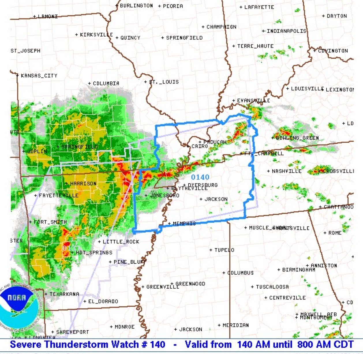
1:42 AM
Severe Thunderstorm Watch for Bollinger, Cape Girardeau, Mississippi, New Madrid, Scott, Stoddard [MO] and Ballard, Caldwell, Calloway, Carlisle, Christian, Crittenden, Fulton, Graves, Hickman, Hopkins, Livingston, Lyon, Marshall, McCracken, McLean, Muhlenberg, Todd, Trigg, Webster [KY] and Alexander, Hardin, Johnson, Massac, Pope, Pulaski, Union [IL] till 8:00 AM CDT
.
1:39 AM
Butler County
Radar shows severe thunderstorms approaching Butler County from the west and south. Very heavy rain will occur with these storms. Wind gusts above 60 mph will also be possible. Hail, as well.
Storms are moving N NE at 50 mph. Let’s be weather aware as these storms move through the area.
Interactive local city-view radars. Clickable watches and warnings.
https://wtalk.co/B3XHASFZ
.
1:37 AM
New Madrid County
Radar shows several thunderstorms capable of producing 60 MPH+ wind gusts moving into New Madrid County from Dunklin and Pemiscot Counties. Hail is also possible.
Storms are moving N NE at 50 mph. The thunderstorms have some weak rotation. Let’s be weather aware as these storms move through the area.
Interactive local city-view radars. Clickable watches and warnings.
https://wtalk.co/B3XHASFZ
.
1:35 AM
Dunklin and Pemiscot Counties.
Radar shows several thunderstorms capable of producing 60 MPH+ wind gusts. Hail, as well.
Storms are moving N NE at 50 mph. The thunderstorms have some weak rotation. Let’s be weather aware as these storms move through the area.
Interactive local city-view radars. Clickable watches and warnings.
https://wtalk.co/B3XHASFZ
.
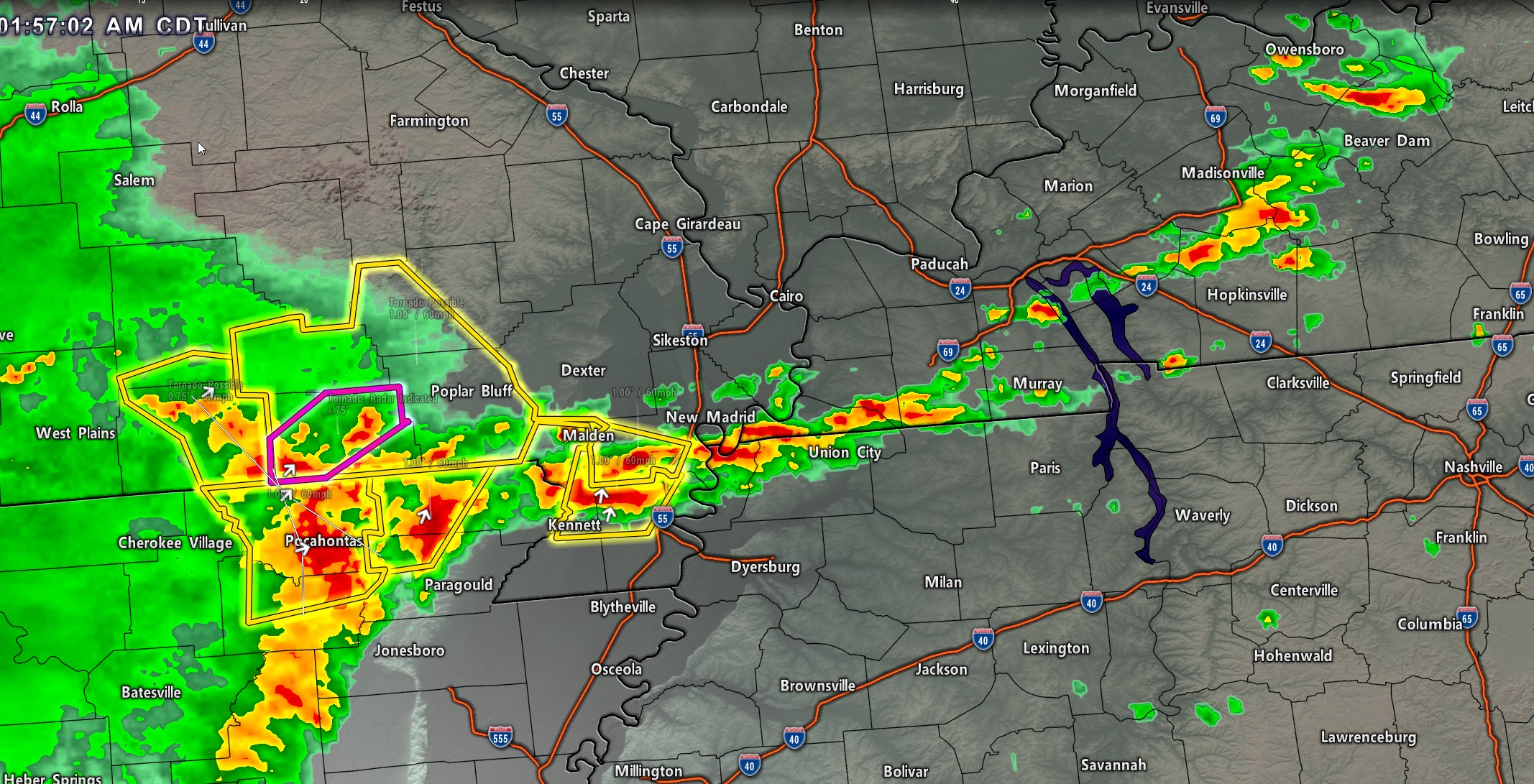
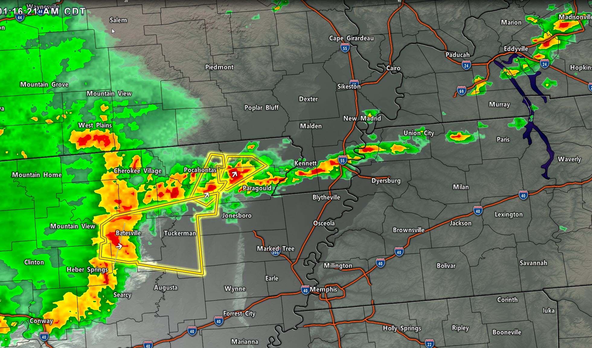
1:16 AM
I am watching storms building in NE AR and the Bootheel. Movement is NE at 50 mph.
Some of these thunderstorms are producing golf ball size hail.
.
1:10 AM
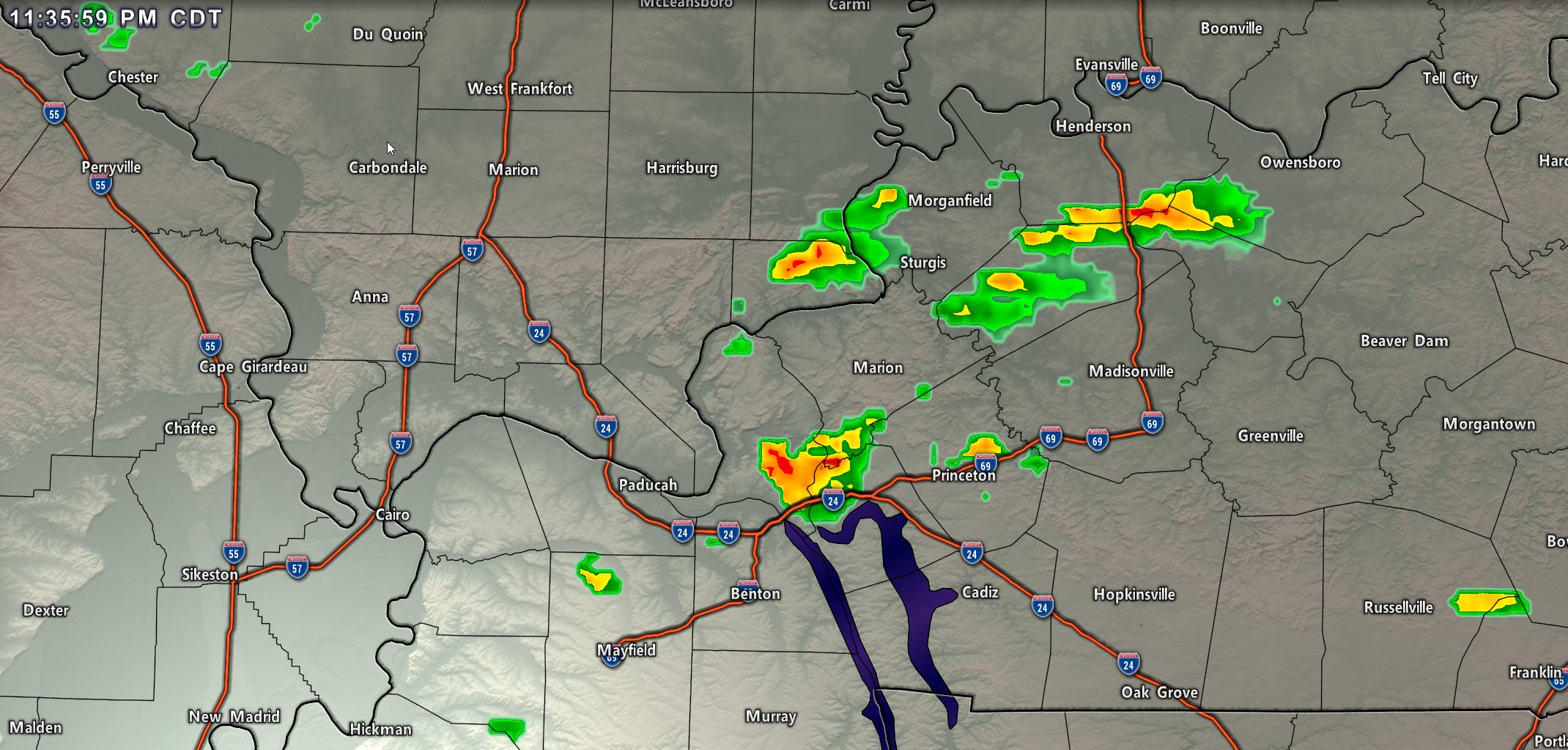
A severe thunderstorm was located near Masonville, KY. Movement is NE at 40 mph. This storm may produce 60 mph wind gusts and hail.
It will mainly impact southeastern Daviess County.
Hail core
.
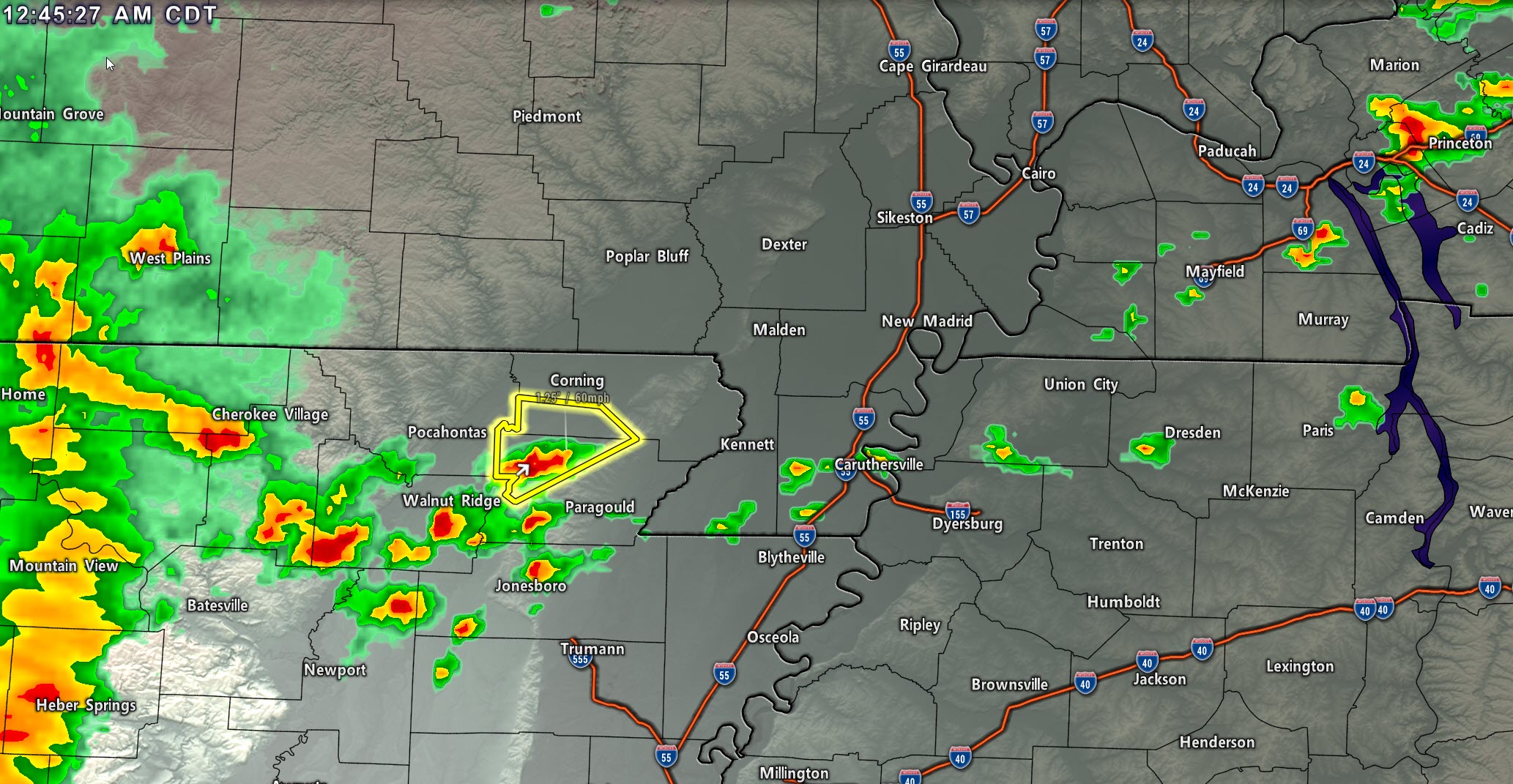
12:46 AM
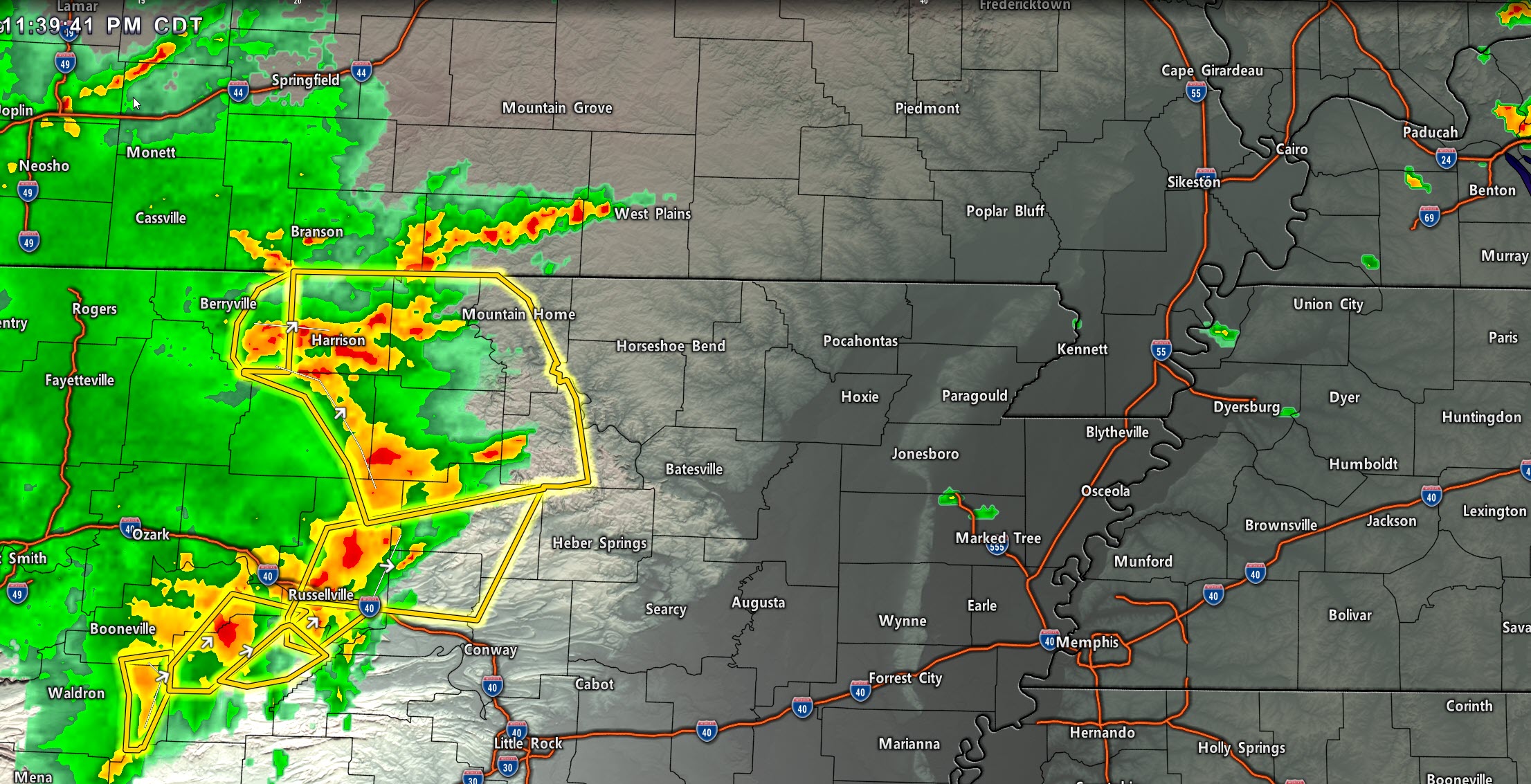
Storms are rapidly forming in northeast Arkansas. Some of these storms are already severe. They will move towards the Bootheel of Missouri and eventually northeast of there.
.
12:10 AM
Storms in western Kentucky are producing dime to nickel size hail. Several reports over the past hour.
See the radars. These storms are moving northeast. For now, they are below severe levels. I can’t rule out a severe thunderstorm warning, but the main concern will be the storms coming out of Arkansas over the coming hours.
.
11:50 PM
You can see the bow echo on the Hrrr model. Future-cast radar.
A bow echo can produce high wind.
.
11:38 PM
Here come the Arkansas storms. Moving E NE.
.
9:15 PM
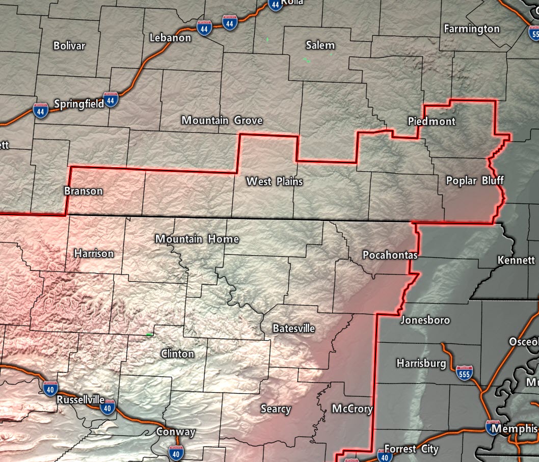
A severe thunderstorm watch is being issued for portions of southern Missouri and Arkansas. It will include Butler County (in my forecast area).
It does include Poplar Bluff. This will last until 4 AM.
.
9:00 PM Update
Click images to enlarge them
.
8:30 PM
Future-cast radar from the Hrrr model
.
6:20 PM Update
May 3, 2021. Overnight severe weather forecast.
A late night event is likely.
There could be a couple of storms over the next few hours, but the main concern will be very late tonight. That means midnight through 9 AM.
Another severe weather threat may materialize Tuesday afternoon. That will depend on what happens tonight.
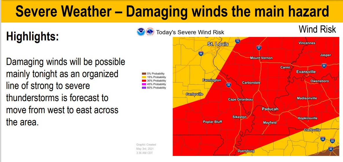
Damaging wind and perhaps isolated tornadoes will be possible with the line of thunderstorms late tonight. There could be a bow echo, which could produce wind gusts above 65 MPH.
Remember, tornado alerts are rapid-fire. That means you will receive multiple alerts as the tornado signature moves across your county (or whatever counties you chose for alerts).
Tornado and severe thunderstorm watches are likely late tonight. Warnings are likely late tonight.
My alerts may have to go out past midnight into the sunrise hours. Just be aware of that. You might want to leave your phone on.
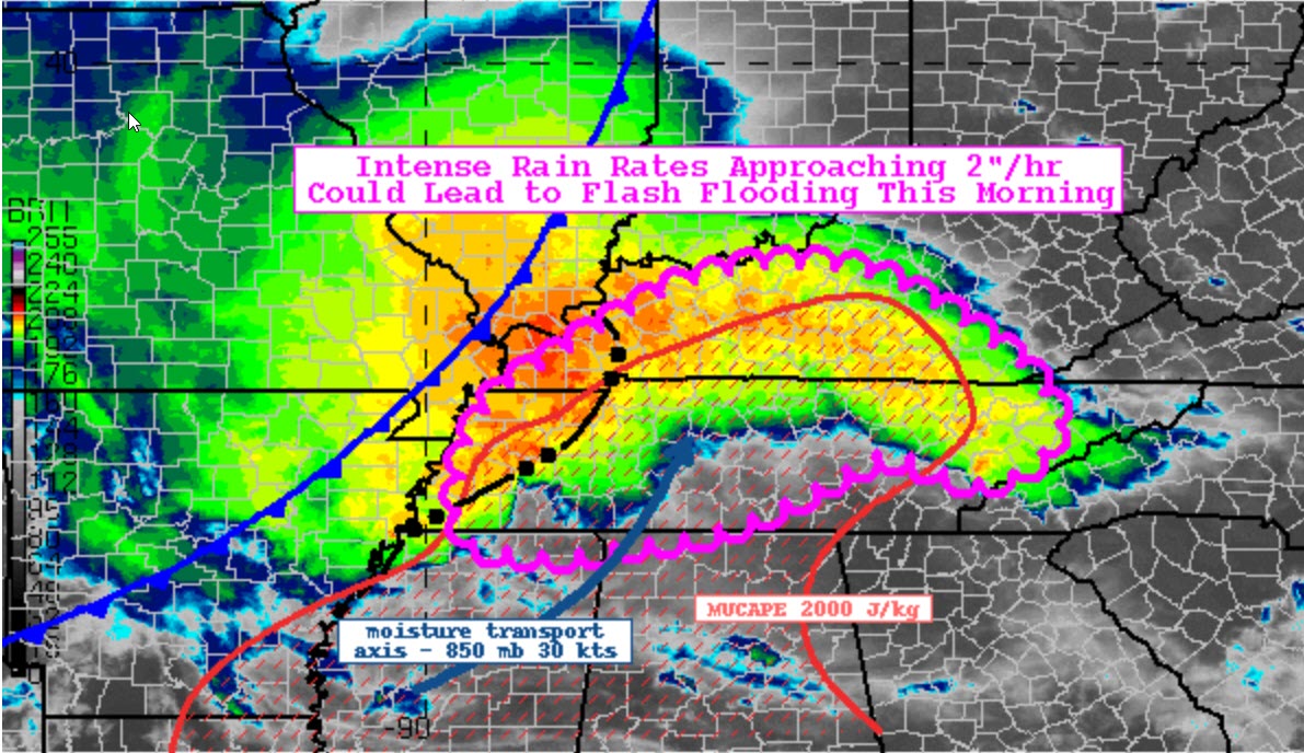
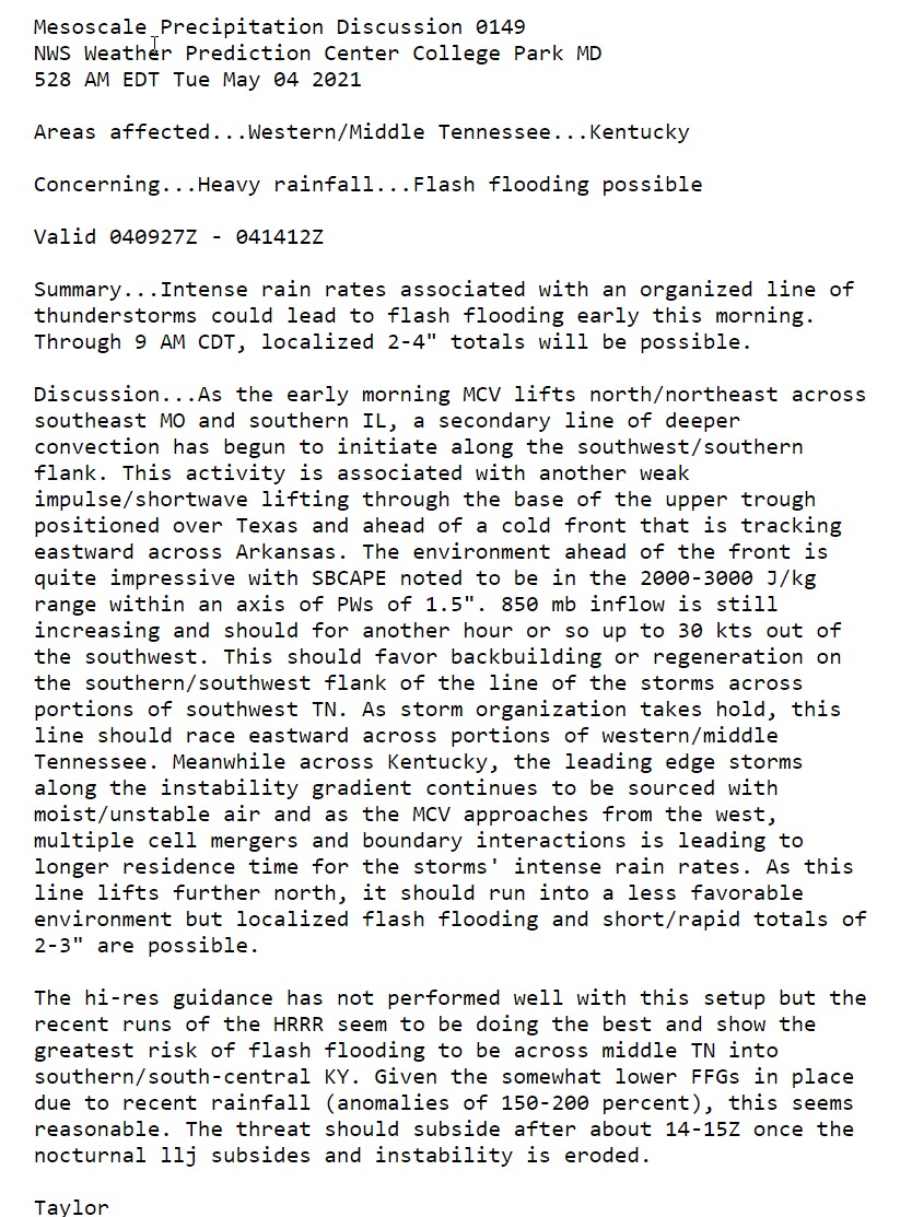
Flash flooding is possible where thunderstorms repeatedly train over the same areas.
Storm Tracking Links
Interactive local city-view radars. Clickable watches and warnings.
https://wtalk.co/B3XHASFZ
Backup radar site in case the above one is not working.
https://weathertalk.com/morani
Regional Radar
https://imagery.weathertalk.com/prx/RadarLoop.mp4
*NEW* Zoom interactive radar (with storm chaser streams)
https://wtalk.co/AVWG7GM7
Real time lightning tracker system two.
https://map.blitzortung.org/#5.02/37.95/-86.99
Lightning Data (zoom in and out of your local area)
https://wtalk.co/WJ3SN5UZ
.
5:00 PM 40% chance of a watch being issued for portions of the region.
.
4:08 PM AFD FROM THE MEMPHIS, TENNESSEE, NWS
.
3:35 PM
Area Forecast Discussion
National Weather Service Paducah KY
323 PM CDT Mon May 3 2021

.SHORT TERM...(Tonight through Tuesday night)
Issued at 323 PM CDT Mon May 3 2021

Complex convective forecast late this afternoon through Tuesday,
but the main concern continues to be late tonight. Forecast
confidence starts off low and dwindles with time.

Satellite is showing some vertical development to the cu field
from the Purchase Area westward into southeast Missouri along a
significant surface moisture gradient, and also to the west of
KSTL near a surface boundary just ahead of the cold front. We
will have to be alert for possible isolated to scattered
development in the southern cu field and also near the cold front
as it approaches our northwest periphery around midnight. The
HRRR and many other CAMs continue to push a strong bowing line
northeast across our region overnight toward 12Z, generally along
and south of the cold front and any outflows from earlier
convection.

The latest trends in the HRRR are not very bullish for convection
this afternoon and evening, but a few strong to severe storms will
be possible given the instability and increasing shear across the
region. SPC's mesoanalysis indicates 1000-2500 J/kg of SBCAPE,
effective Bulk Shear of 35-45kts, and effective SRH of 100+m2/s2.
Not sure if we could get supercells, but some level of
organization is likely if any storms can get going through early
evening. Large hail and localized damaging winds would be the main
concerns with any early evening convection.

There is some increase in potential for convection to develop
along the cold front later this evening. Any convection late this
evening, whether off the cold front, or left over diurnal
convection, would tend to become linear and dive southeast across
the area. Damaging winds would be the primary threat, but locally
heavy rainfall may be the bigger concern with this potential
scenario, especially as it loses steam over west Kentucky.

The overnight bow echo potential will be most impactful if we
don't get any significant convection in the meantime. The portion
of the area that could be effected will be limited by the cold
frontal position and any outflow boundaries. Southern portions of
southeast Missouri and the Purchase Area are the most likely areas
to experience the damaging wind potential late tonight toward
daybreak Tuesday. Tornadoes would also be possible if the bowing
line reaches our region. Another concern is the very fast movement
of the bow, as seen in the CAMs.

As for Tuesday, forecast confidence is very low given uncertainties
in boundary locations and thermodynamic and shear profiles after
tonight's convection plays out. We could see some lingering
showers/storms in the morning over the northeast half of the area,
but any regeneration may be hard to get. However, if we get any
sunshine ahead of the cold front, a few strong storms would be
possible in the afternoon, mainly over west Kentucky. Severe
weather cannot be ruled out, but until the dust settles on
tonight's event it will be very difficult to pin down. With each
round of convection that actually occurs, the flash flood
potential will increase, but it does not look overly concerning at
this time, especially given all of the uncertainty.
.
3:30 PM Update
Severe thunderstorm watch.
.
2:30 PM Update
SPC may issue a watch for portions of Missouri and Illinois. One of many to come.
.
1:30 PM Update
High resolution Hrrr model shows supercells at first with possibly hail and wind. Then, a line of severe storms late tonight. One model’s idea. It is a short-range model and usually does okay.
.
10 AM Update
Some of the data is starting to show thunderstorms developing earlier. Some storms could form after 4 PM this afternoon. If that happens, then they could be severe.
Monitor updates.
Hrrr mode. Future-cast radar.
.
6 AM Monday Update
The stage has been set for a risk of severe weather this afternoon into Tuesday afternoon.
More than one round of storms is likely.
Models are not in perfect agreement as to the exact timing of the storms.
It appears that the atmosphere will be capped this afternoon. Read further done in the blog about CAP’s.
Then, cooler air aloft and forcing moves in tonight and tomorrow. This could be a very late night event. Meaning after 11 PM.
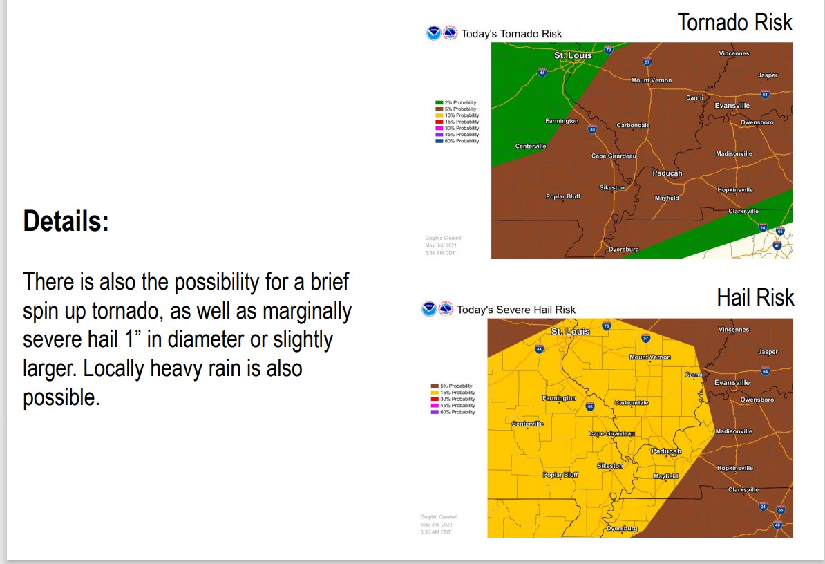
Some of these thunderstorms are likely to produce hail and damaging wind. A non-zero tornado threaet.
Any line segments or bowing could produce winds to 70 mph. Individual storms could produce hail up to the size of golf balls.
The Storm Prediction Center has our region in a level 3 out of 5 severe weather risk. An enhanced risk.
Make sure your Beau Dodson Weather app is working. Open it up. Make sure you are signed into it.
Another chance of intense thunderstorms will develop Tuesday late morning into the evening hours. This potential event will be a tad further east and perhaps include extreme south Illinois, southeast Illinois, western Kentucky, and northwest Tennessee.
We will need to monitor all of these thunderstorm chances. It is going to be a long 24 to 36 hours for meteorologists.
Stay tuned.
Future-cast radars.
What am I looking at?
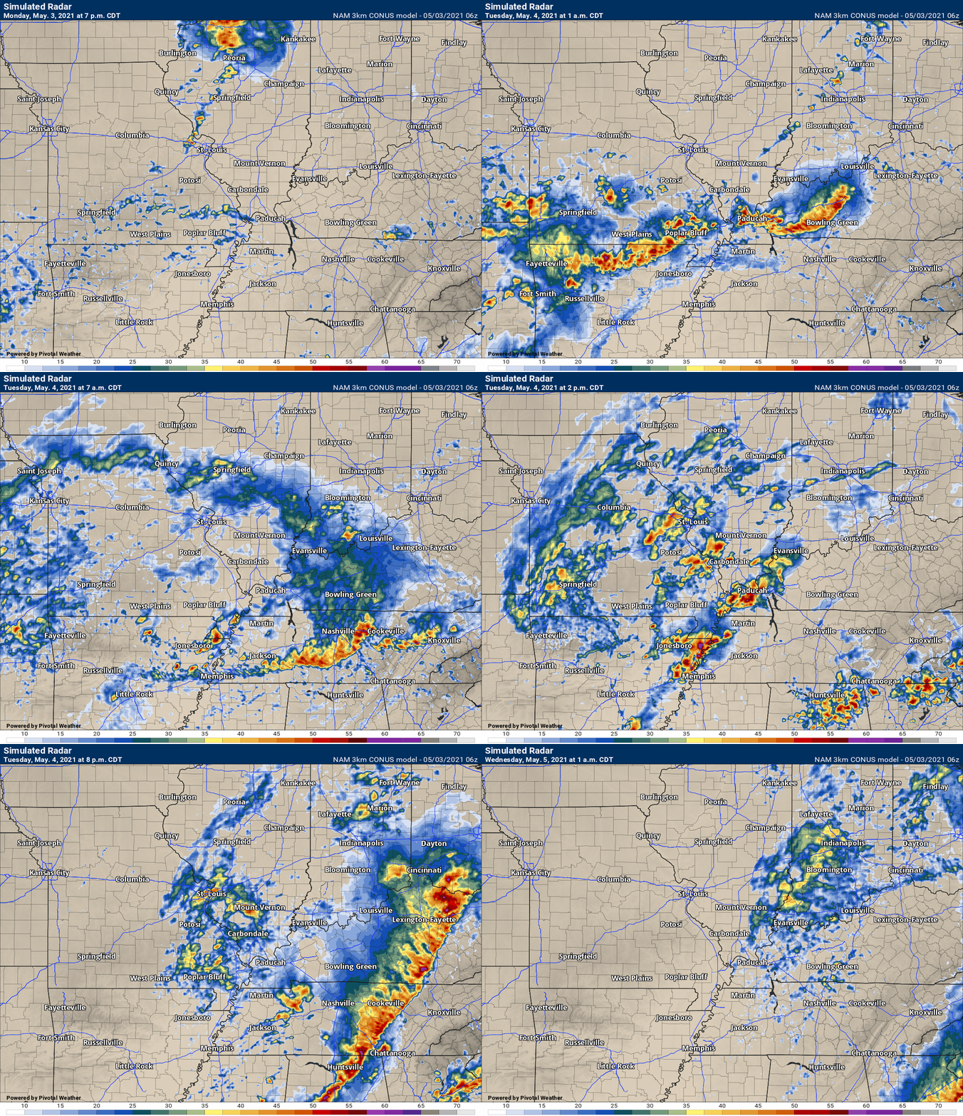
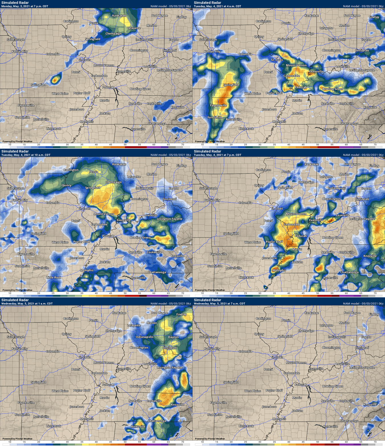
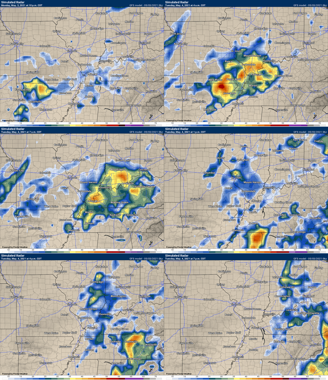
You are looking at different models. Meteorologists use many different models to forecast the weather. All models are wrong. Some are more wrong than others. Meteorologists have to make a forecast based on the guidance/models.
I show you these so you can see what the different models are showing as far as precipitation. If most of the models agree, then the confidence in the final weather forecast increases.
This animation is the Storm Prediction Center WRF model.
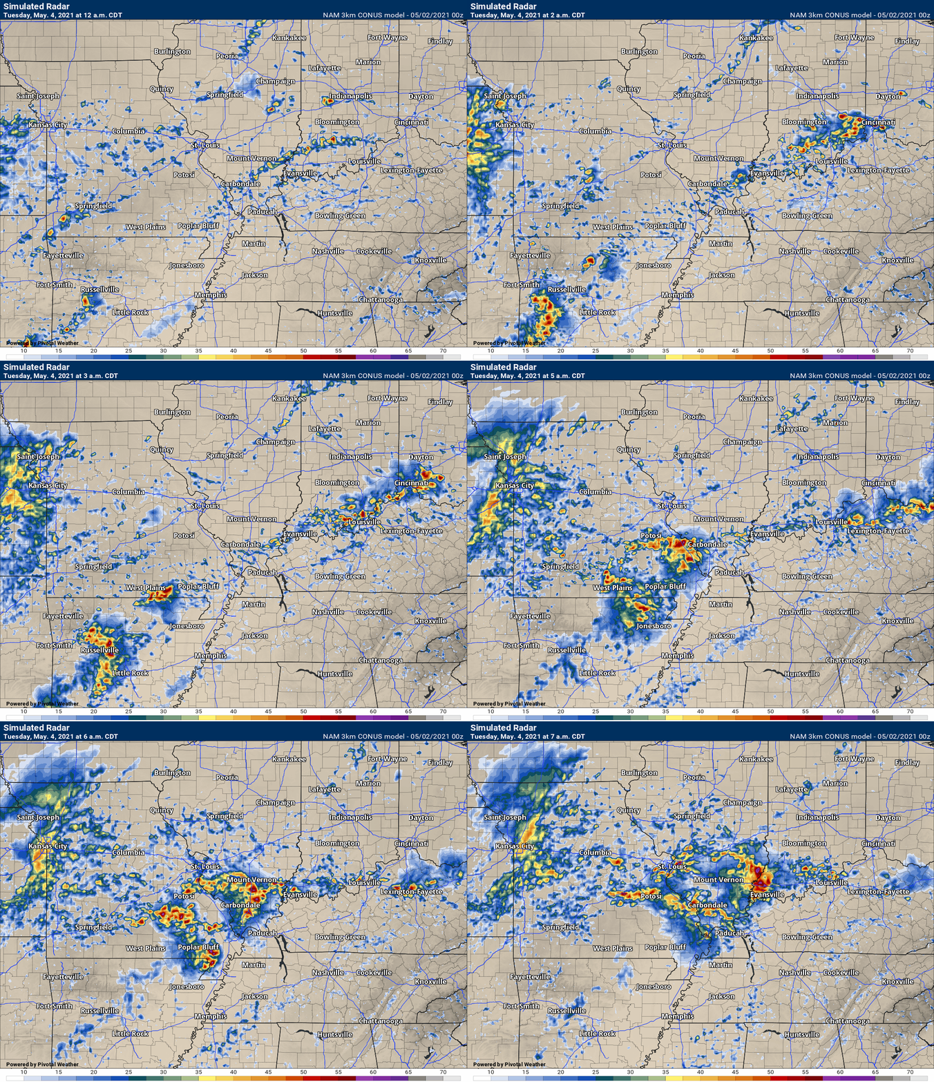
This animation shows you what radar might look like as the next system pulls through the region. It is a future-cast radar.
Time-stamp upper left. Click the animation to enlarge it.
.
This animation is the Hrrr short-range model.
.
.This animation is the 3K NAM American Model.
This animation shows you what radar might look like as the next system pulls through the region. It is a future-cast radar.
Time-stamp upper left. Click the animation to enlarge it.
.
This next animation is the lower-resolution NAM American Model.
This animation shows you what radar might look like as the system pulls through the region. It is a future-cast radar.
Time-stamp upper left. Click the animation to enlarge it.
This next animation is the GFS American Model.
This animation shows you what radar might look like as the system pulls through the region. It is a future-cast radar.
Time-stamp upper left. Click the animation to enlarge it.
.
.
10 PM Sunday night.
I am predicting that the CAP breaks Monday night into Tuesday.
Large hail and damaging wind is likely in our region. Golf ball size hail will be possible. Damaging wind gusts to 70 mph will also be a possibility.
This is the most significant event this year (severe wise). We have not had much in the way of severe weather. That may change.
It also appears that another chance of severe storms will form along a cold front late Tuesday morning into Tuesday afternoon.
That would most likely impact western Kentucky, far southern Illinois, and Tennessee.
Stay tuned for updates.
.

![]()
.Weather advice:
Monitor updates concerning the potential of severe weather Monday and Tuesday. Peak time-frame could end up after midnight Monday into early Tuesday morning. That doesn’t mean storms can’t form before then.
.
Weather Discussion
-
- Scattered showers/storms Sunday and Sunday night/Monday morning.
- A greater risk of severe thunderstorms late Monday into early Tuesday morning. Perhaps a few more Tuesday afternoon.
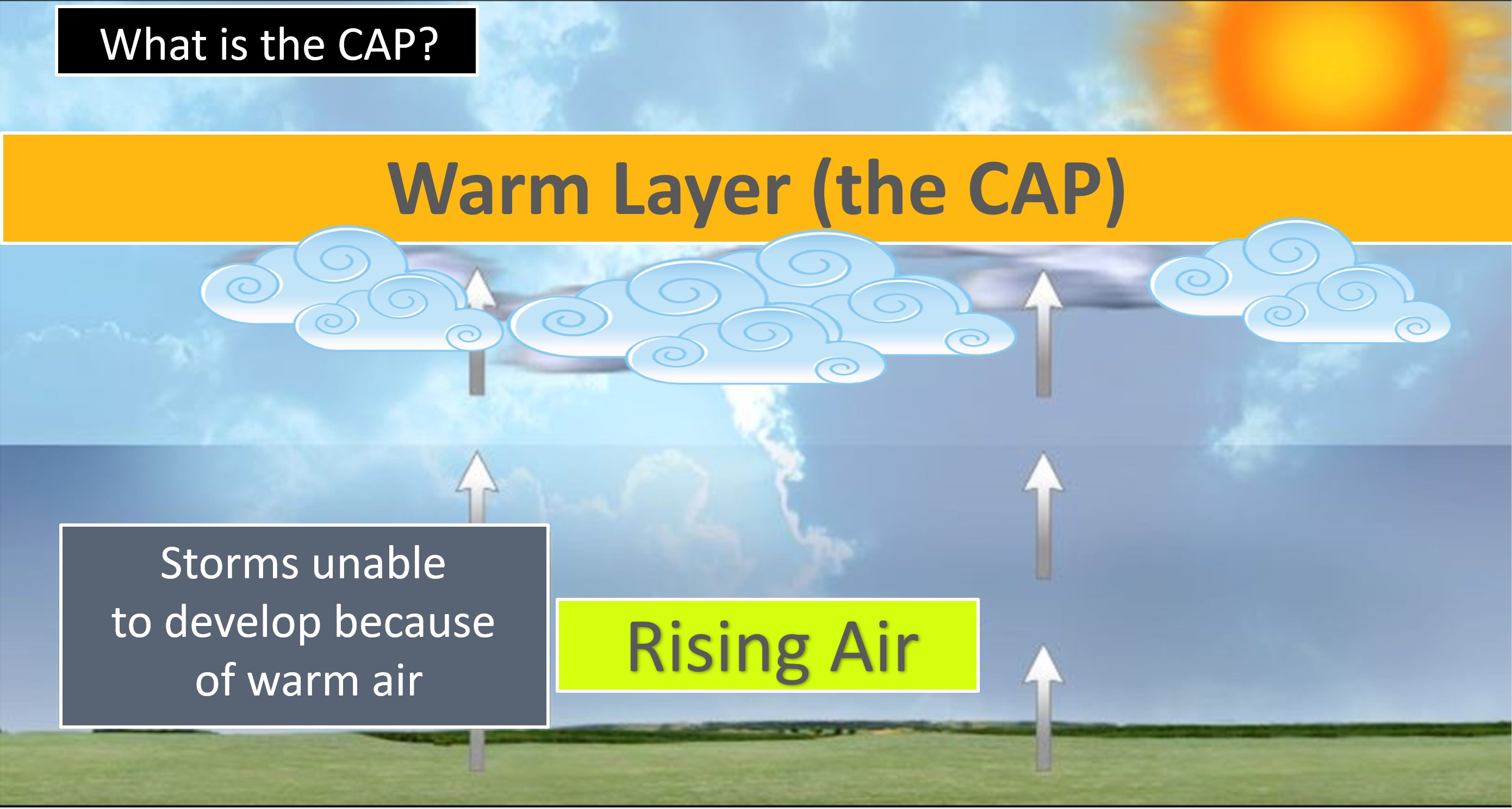
- Confidence in thunderstorms forming is very low, because of a CAP. An area of warm air aloft that could prevent storms from forming.
Good day, everyone.
We have two weather systems to deal with over the next couple of days.
The first one will move through today and tonight (Sunday). A few showers and thunderstorms. A few of the storms could be intense late Sunday night into early Monday morning.
Then, a lull.
New storms could form late Monday into Tuesday.
There will be a CAP on the atmosphere Monday afternoon and evening. This could prevent thunderstorms from forming.
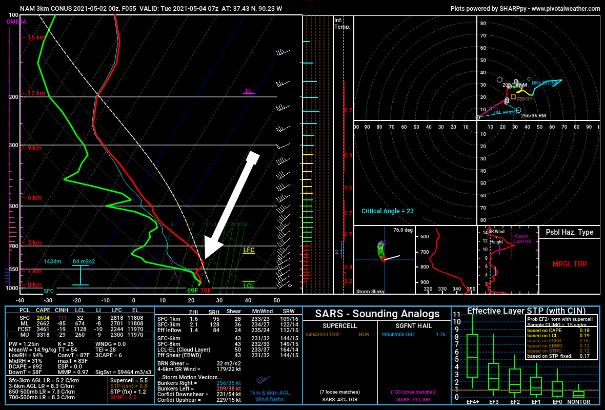
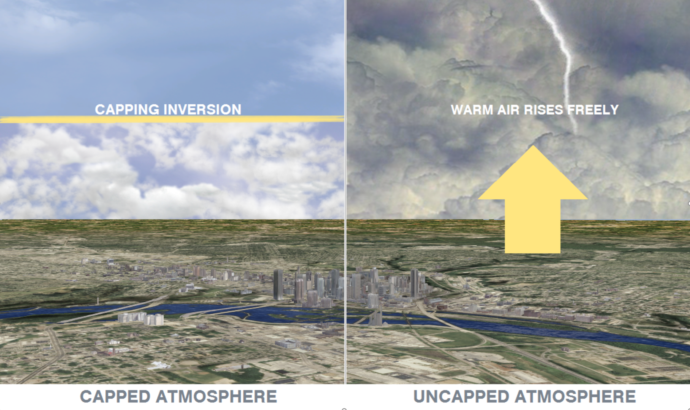
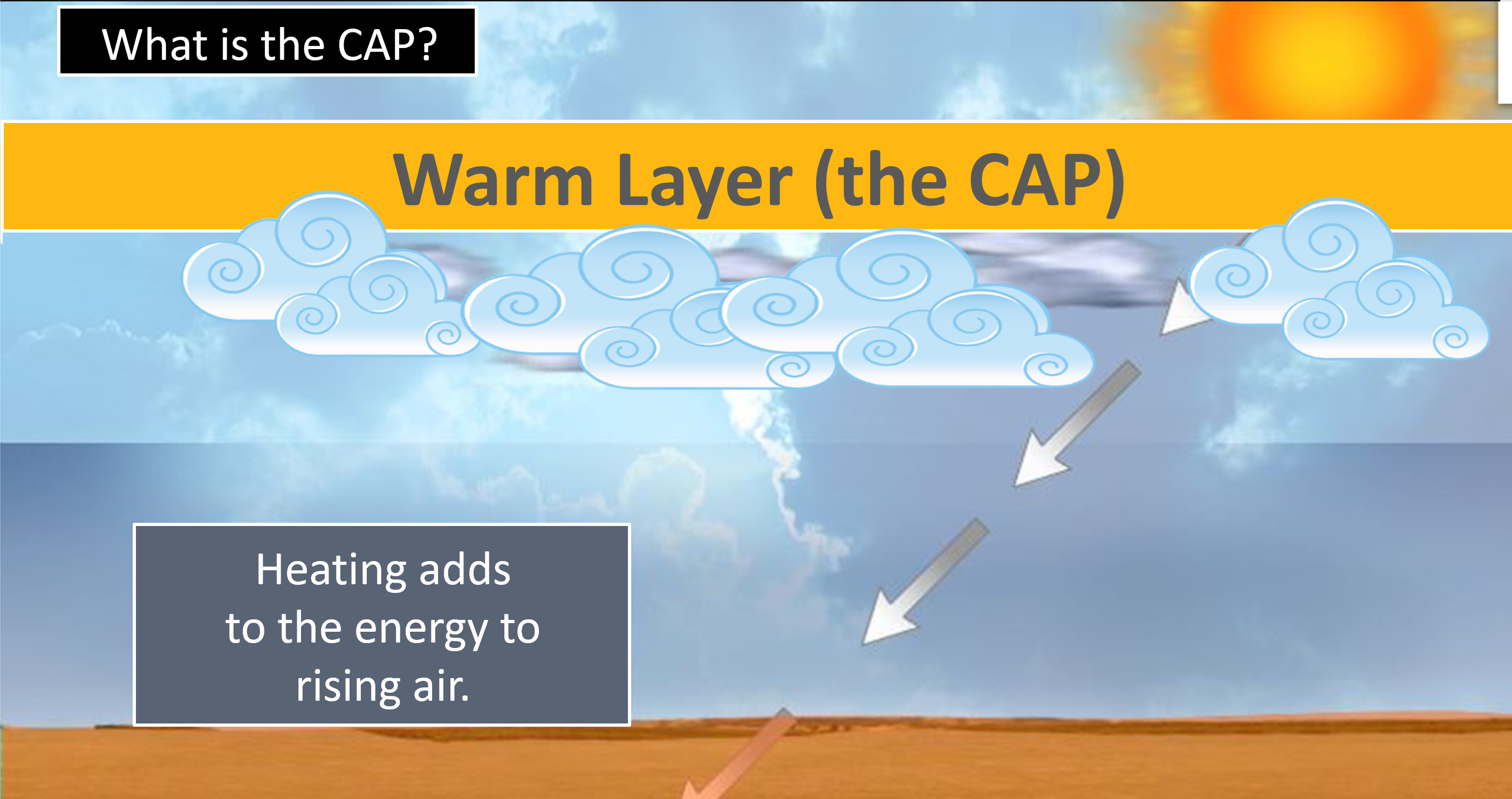
What is a CAP.
This white arrow shows you where the red line is jogging to the right. That is warm air aloft. It is keeping a lip on the atmosphere. Preventing storms from forming.
If the CAP does not break, then storms won’t form from the surface upwards. You can have storms form above the CAP, but typically they don’t produce as much severe weather. They can still produce large hail and gusty wind.
.
More information on what a CAP is.
.
.
.
This is a low confidence forecast. The atmosphere will be very unstable Monday night into early Tuesday morning. I am concerned if the CAP does break that some storms will produce 70 mph wind gusts and golf ball size hail. A low-end tornado risk, as well.
This needs to be closely monitored.
I may have to send out app messages late at night.
The cold front may linger long enough Tuesday to help produce some additional storms across western Kentucky and northwest Tennessee.
.
Today’s outlook (below).
Light green is where thunderstorms may occur but should be below severe levels.
Dark green is a level one risk. Yellow is a level two risk. Orange is a level three (enhanced) risk. Red is a level four (moderate) risk. Pink is a level five (high) risk.
One is the lowest risk. Five is the highest risk.
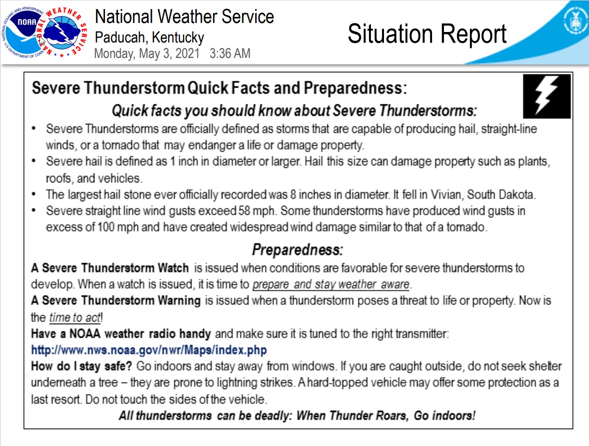
A severe storm is one that produces 58 mph wind or higher, quarter size hail, and/or a tornado.
The tan states are simply a region that SPC outlined on this particular map. Just ignore that.

The black outline is our local area.

.
Tomorrow’s severe weather outlook.

![]()
![]()
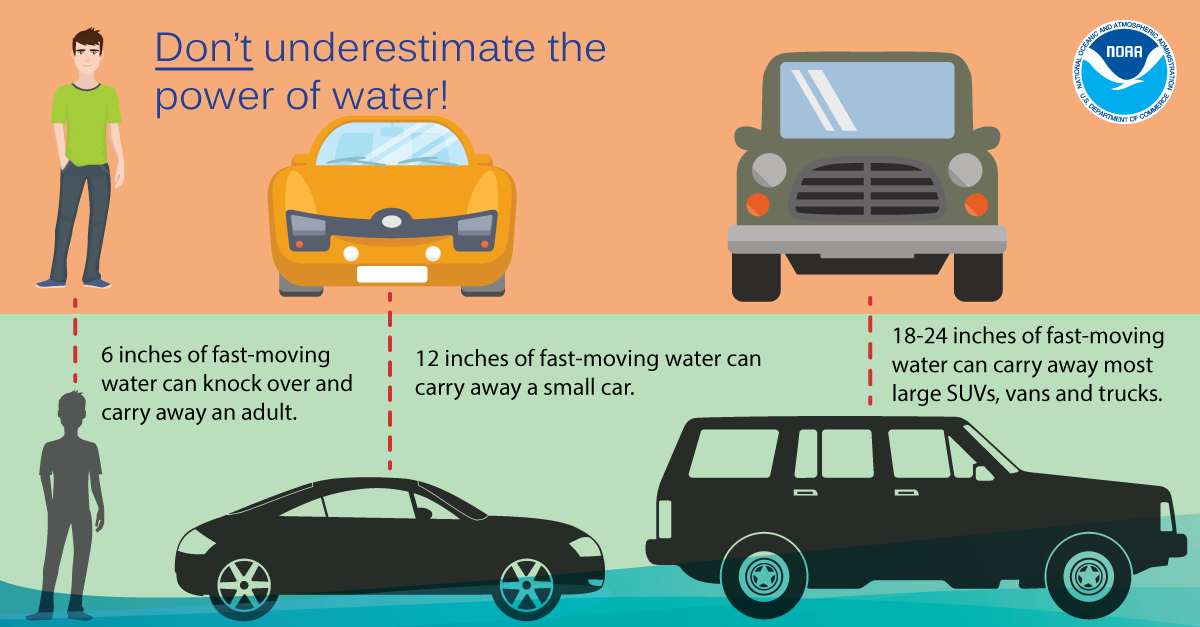
Some safety graphics.
.![]()
.

Again, as a reminder, these are models. They are never 100% accurate. Take the general idea from them.
What should I take from these?
- The general idea and not specifics. Models usually do well with the generalities.
- The time-stamp is located in the upper left corner.
- The EC European weather model is in Zulu time.
.
What am I looking at?
You are looking at different models. Meteorologists use many different models to forecast the weather. All models are wrong. Some are more wrong than others. Meteorologists have to make a forecast based on the guidance/models.
I show you these so you can see what the different models are showing as far as precipitation. If most of the models agree, then the confidence in the final weather forecast increases.
This animation shows you what radar might look like as the next system pulls through the region. It is a future-cast radar.
Time-stamp upper left. Click the animation to enlarge it.
This animation is the NAM model
.
What you need to know.
Key Points
- A low confidence forecast because of a CAP that could prevent storms from forming Monday afternoon into Tuesday morning.
- If thunderstorms do form then damaging wind and large hail will likely occur. An isolated tornado risk, as well.
- Thunderstorms will also produce torrential rain.
- It appears the greatest risk of storms may hold off until late Monday night. Storms could form before then, but the chances appear higher late Monday night into Tuesday morning.
- Have your Beau Dodson Weather app on. Check it. Make sure you have not logged out of the app.
- Remember, a watch means to monitor updates. A warning means to seek shelter. A warning is a higher threat.
.
Call to action.
Monitor updated weather forecasts.
Have a safety plan.
Make sure you are using the Beau Dodson Weather Talk app. Download it from the app store. It is under Weather Talk.
The app is for subscribers (please log into your account and make sure your payment has been updated. We have a large number of declined cards and PayPal payments.
Subscribe at www.weathertalk.com/welcome then go to your app store and search for WeatherTalk. Apple users click here. Android users click here .
.
Day one outlook.

.
Day two outlook.

.

Radar Link: Interactive local city-view radars & regional radars.
You will find clickable warning and advisory buttons on the local city-view radars.
If the radar is not updating then try another one. If a radar does not appear to be refreshing then hit Ctrl F5. You may also try restarting your browser.
Not working? Email me at beaudodson@usawx.com
Backup radar site in case the above one is not working.
https://weathertalk.com/morani
New ZOOM radar (with storm chasers)
https://wtalk.co/AVWG7GM7
Regional Radar
https://imagery.weathertalk.com/prx/RadarLoop.mp4
Lightning Data (zoom in and out of your local area)
https://wtalk.co/WJ3SN5UZ
Satellite Data
Computers and tablets. These two satellite links may not work well on cell phones.
Visible Satellite. This one is to be used during daylight only. Be sure and hit refresh once you are on the satellite page. Otherwise, the data will be old.
https://col.st/a5A0e
IR Satellite. This one shows cloud temperatures. Bright colors represent cold cloud tops. That could mean thunderstorms. Be sure and hit refresh once you are on the satellite page. Otherwise, the data will be old.
https://col.st/R2fw1
Water Vapor Satellite. This one shows mid-level moisture in the atmosphere. Be sure and hit refresh once you are on the satellite page. Otherwise, the data will be old.
https://col.st/xFVwx
.

Live lightning data: Click here.
Not receiving app/text messages?
USE THE APP. ATT and Verizon are slowing or stopping the text messages.
Make sure you have the correct app/text options turned on. Find those under the personal notification settings tab at www.weathertalk.com. Red is off. Green is on.
Subscribers, PLEASE USE THE APP. ATT and Verizon are not reliable during severe weather. They are delaying text messages.
The app is under WeatherTalk in the app store.
Apple users click here
Android users click here
.


