

.
I have some question-and-answer threads over on the Facebook page. Link to those threads CLICK HERE
Or email me at beaudodsonweather@gmail.com
.

🌪️ Seven-Day Tornado Outlook ⛈️
May 21th through May 27th
Current risk: Currently, we do not have a tornado risk.
Current confidence level: Medium confidence in the forecast.
Comment: At this time, I have kept the risk of tornadoes out of the forecast. I will monitor this weekend and next week.
.

Seven-Day Hazardous Weather Outlook
1. Is lightning in the forecast? YES. Lightning is possible over southern Missouri, the Missouri Bootheel, southwest Kentucky, and western Tennessee tonight. Dry Thursday and Friday. Lightning is possible area-wide late Friday night into at least next Tuesday night. Perhaps beyond Tuesday night.
2. Are severe thunderstorms in the forecast? Monitor. A few storms could produce hail tonight across southern Missouri into western Tennessee. A smaller chance across southwest Kentucky. I will monitor Saturday into next week.
There are no strong signals for severe weather through Sunday night. There are signals for thunderstorms. I can’t rule out adjustments in the severe weather forecast. Monitor updated forecasts over the coming day.
3. Is flash flooding in the forecast? SCATTERED RISK. On and off periods of rain into next week. With repeated rounds of thunderstorms, I can’t rule out some spotty water issues.
4. Will non-thunderstorm winds top 40 mph? NO.
5. Will temperatures rise above 90 degrees? NO.
6. Will the heat index rise above 100 degrees? NOT AT THIS TIME.
.
A quick forecast glance. Your 48-hour forecast Graphics


.

.


Forecast discussion.
- Cooler weather into the weekend. Some nights will dip into the 40s.
- We will have shower and thunderstorm chances tonight across our southern counties.
- Dry on Thursday and Friday.
- Shower and thunderstorm chances ramp back up on Friday night into next week.
- If you have weekend plans, then monitor updates.
.

.
Good morning, everyone
Well, your weatherman is tired. I bet you are, as well. Our severe weather season continues to give.
The nation is now up to over 950 tornadoes for the year. Not quite there, yet. Close.
Our region has experienced more than sixty tornadoes. The Paducah, Kentucky, NWS forecast area has had over 50 tornadoes. Add in my far NW and southern counties (outside of the Paducah, KY, NWS area), the number is over sixty.
We did have a few tornadoes yesterday. Early yesterday morning, at least one or two tornadoes touched down in southeast Missouri and southern Illinois.
One tornado struck Union and Johnson County, Illinois. Probably an EF0 or EF1. We will see what the NWS finds.
Then, we had more severe weather yesterday afternoon. Mainly hail and wind. We will have to wait and see if there were a few tornadoes in western Kentucky and western Tennessee.
The good news is that we are waking up to much nicer weather conditions this morning. Enjoy!
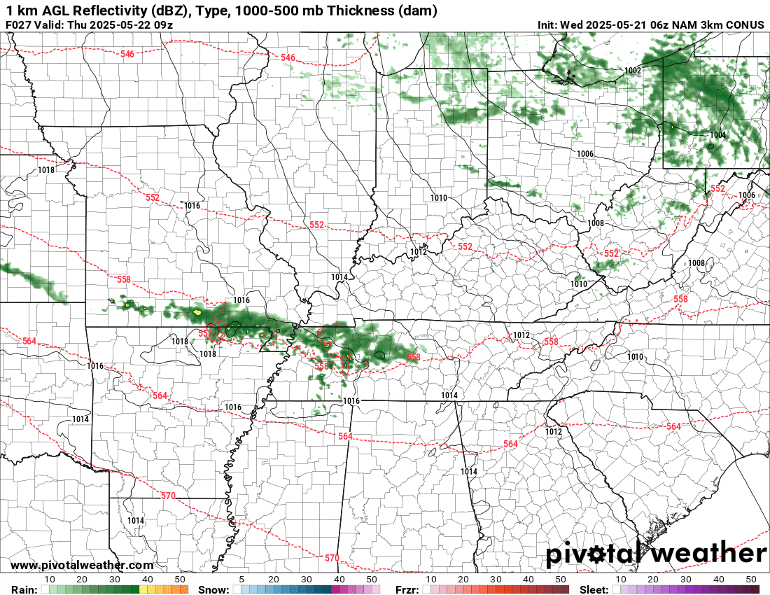
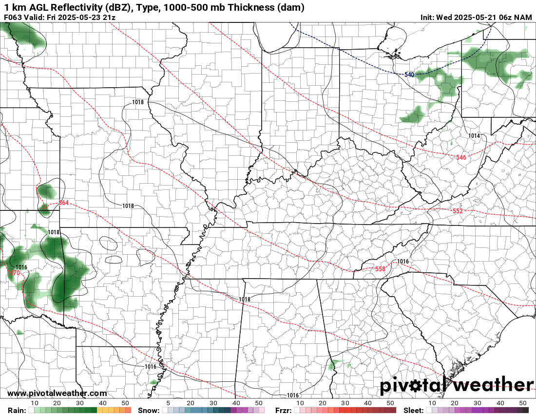
A disturbance will push northwest to southeast tonight. This will bring some showers and thunderstorms back into the region, mainly across southern Missouri and western Tennessee. It might clip western Kentucky.
Here is what the NAM model shows tonight. You can see the placement.
This will be close to accurate. It is a model, of course. But, you get the general idea for tonight.
.
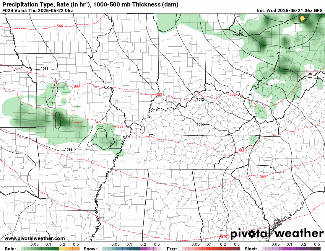
A few of the storms could produce hail. There is a small risk of large hail. The worst of that event may stay off to our south and southwest. I will monitor it.
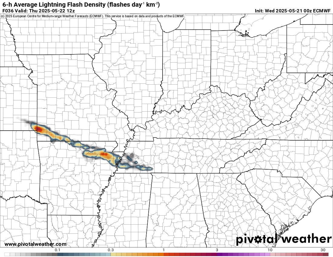
The EC future-cast lightning keeps it a bit farther south and west late tonight. We are on the cool side of the boundary.
.
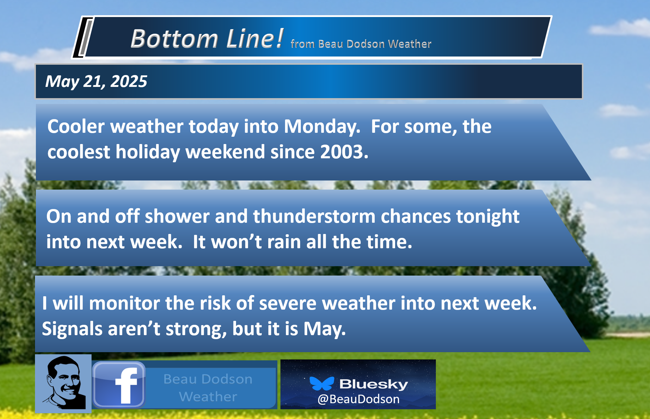
It will be cooler today into early next week.
Perhaps one of the coolest Memorial Day weekends in quite a few years.
Highs will be in the 60s and lower 70s, for the most part.
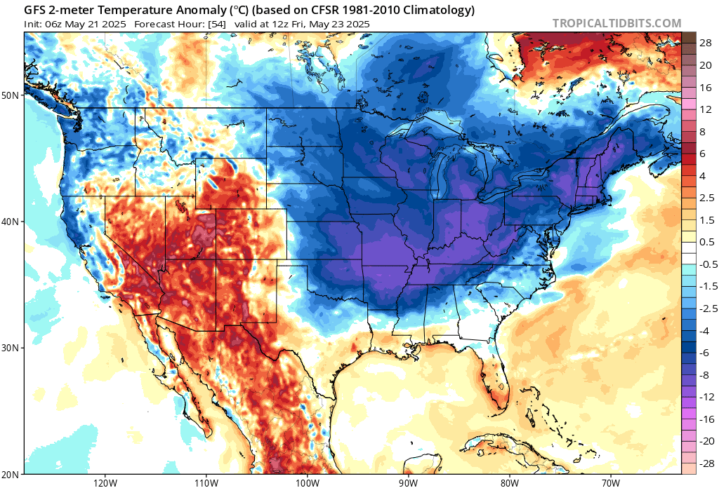
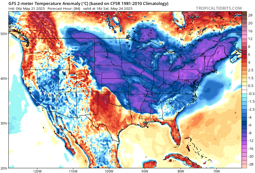
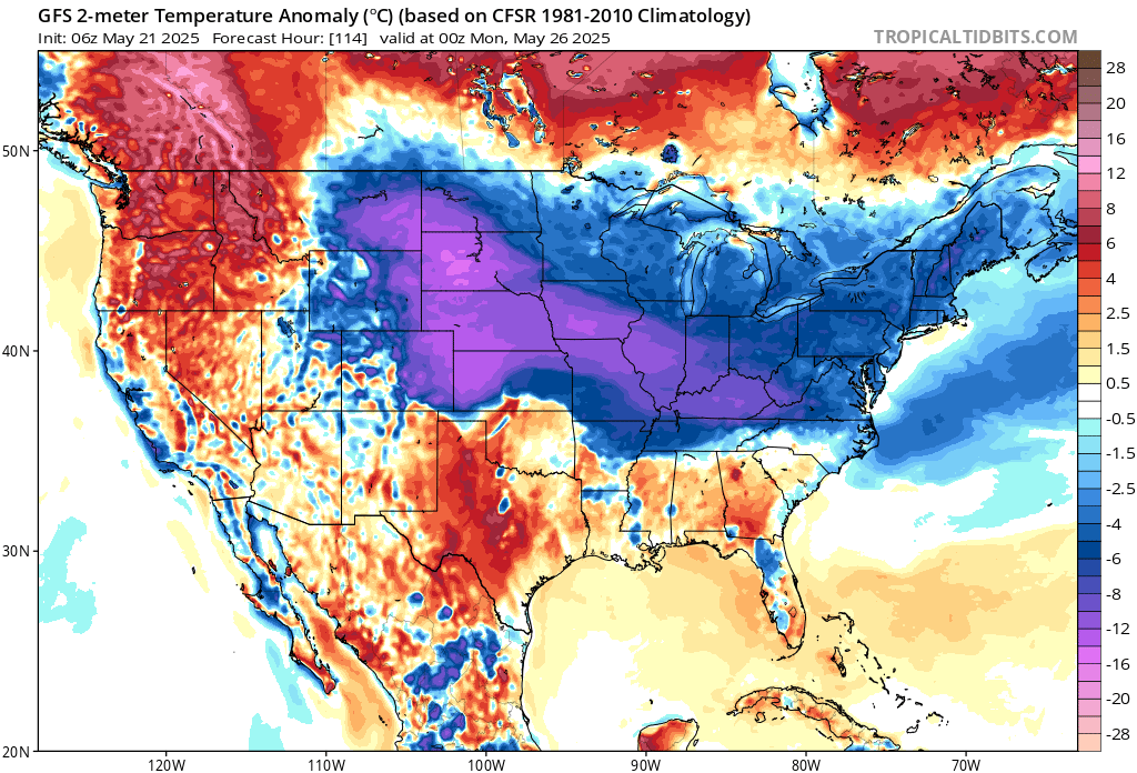
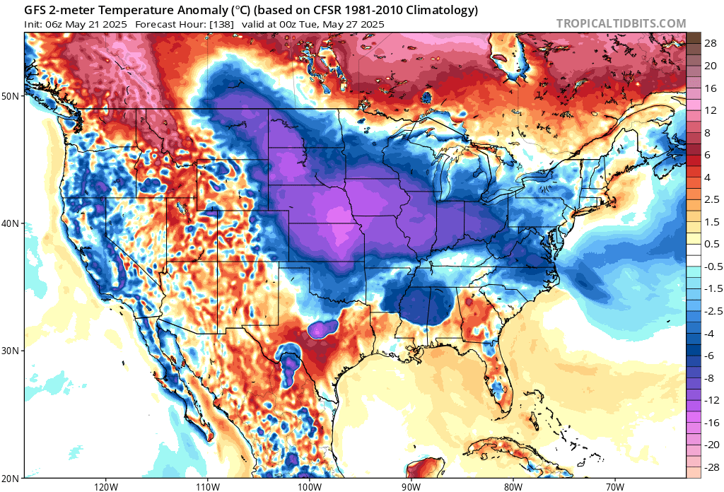
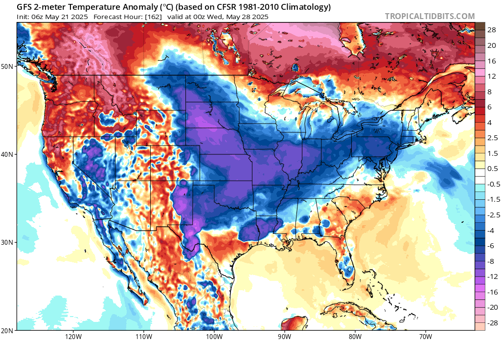
Check out these temperature anomaly maps. The blue and pink are below to well below average temperatures.
They show you how many degrees below average temperatures will be. Normal highs for this time of the year are around 80 degrees. Normal lows are around 60 degrees.
Thursday’s temperature anomalies
Friday’s temperature anomalies
.
Saturday’s temperature anomalies
.
Sunday’s temperature anomalies
.
Monday’s temperature anomalies
.
Tuesday’s temperature anomalies
.
The bottom line is that it will be cooler than usual.
If you have outdoor plans this weekend, then monitor updated forecasts. Showers and thunderstorms will be an issue Friday night into next week.
It will not rain all the time, but there will be periods of precipitation.
If you have outdoor plans, then monitor updated forecasts.
There are some questions about Saturday’s forecast. Some data keeps the higher rain chances out of our region. Other data, hits us directly.
Have a plan B, in case it rains.
It does appear rain chances will be higher Saturday night into Sunday night.
Some of the rain could be locally heavy.
There are no strong signals for severe weather Friday night through Sunday night.
It is spring. It is May. I will be monitoring the severe weather risks. If there are adjustments, then I will let you know through the app.
Precipitation chances are likely to continue into Monday and Tuesday of next week. Perhaps beyond.
I am monitoring late May and early June for additional severe weather concerns.
.

The timestamp (upper left) is in Zulu. 12z=7 am. 18z=1 pm. 00z=7 pm.
Double-click the animation to enlarge it.
NAM model.
.
Here is the GFS model
.
.
.
Click here if you would like to return to the top of the page.
.Average high temperatures for this time of the year are around 80 degrees.
Average low temperatures for this time of the year are around 60 degrees.
Average precipitation during this time period ranges from 1.00″ to 1.40″
Six to Ten Day Outlook.
Blue is below average. Red is above average. The no color zone represents equal chances.
Average highs for this time of the year are in the lower 60s. Average lows for this time of the year are in the lower 40s.

Green is above average precipitation. Yellow and brown favors below average precipitation. Average precipitation for this time of the year is around one inch per week.

.

Average low temperatures for this time of the year are around 60 degrees.
Average precipitation during this time period ranges from 1.20″ to 1.50″
.
Eight to Fourteen Day Outlook.
Blue is below average. Red is above average. The no color zone represents equal chances.

Green is above average precipitation. Yellow and brown favors below average precipitation. Average precipitation for this time of the year is around one inch per week.

.
.
.
We have a new service to complement your www.weathertalk.com subscription. This does NOTreplace www.weathertalk.com It is simply another tool for you to receive severe weather information.
.


.

Radars and Lightning Data
Interactive-city-view radars. Clickable watches and warnings.
https://wtalk.co/B3XHASFZ
Old legacy radar site (some of you like it better)
https://weatherobservatory.com/weather-radar.htm
If the radar is not updating then try another one. If a radar does not appear to be refreshing then hit Ctrl F5. You may also try restarting your browser.
Backup radar site in case the above one is not working.
https://weathertalk.com/morani
Regional Radar
https://imagery.weathertalk.com/prx/RadarLoop.mp4
** NEW ** Zoom radar with chaser tracking abilities!
ZoomRadar
If the radar is not working, then email me: Email me at beaudodson@usawx.com
.
We do have some sponsors! Check them out.
Roof damage from recent storms? Link – Click here
INTEGRITY ROOFING AND EXTERIORS!
⛈️ Roof or gutter damage from recent storms? Today’s weather is sponsored by Integrity Roofing. Check out their website at this link https://www.ourintegritymatters.com/

![]()
![]()
![]()
Make sure you have three to five ways of receiving your severe weather information.
Weather Talk is one of those ways! Now, I have another product for you and your family.

.
Want to add more products to your Beau Dodson Weather App?
Receive daily videos, weather blog updates on normal weather days and severe weather and winter storm days, your county by county weather forecast, and more!
Here is how to do add those additional products to your app notification settings!
Here is a video on how to update your Beau Dodson Weather payment.
The app is for subscribers. Subscribe at www.weathertalk.com/welcome then go to your app store and search for WeatherTalk
Subscribers, PLEASE USE THE APP. ATT and Verizon are not reliable during severe weather. They are delaying text messages.
The app is under WeatherTalk in the app store.

Apple users click here

Android users click here
.
Radars and Lightning Data
Interactive-city-view radars. Clickable watches and warnings.
https://wtalk.co/B3XHASFZ
Old legacy radar site (some of you like it better)
https://weatherobservatory.com/weather-radar.htm
If the radar is not updating then try another one. If a radar does not appear to be refreshing then hit Ctrl F5. You may also try restarting your browser.
Backup radar site in case the above one is not working.
https://weathertalk.com/morani
Regional Radar
https://imagery.weathertalk.com/prx/RadarLoop.mp4
** NEW ** Zoom radar with chaser tracking abilities!
ZoomRadar
Lightning Data (zoom in and out of your local area)
https://wtalk.co/WJ3SN5UZ
Not working? Email me at beaudodson@usawx.com
National map of weather watches and warnings. Click here.
Storm Prediction Center. Click here.
Weather Prediction Center. Click here.
.

Live lightning data: Click here.
Real time lightning data (another one) https://map.blitzortung.org/#5.02/37.95/-86.99
Our new Zoom radar with storm chases
.
.

Interactive GOES R satellite. Track clouds. Click here.
GOES 16 slider tool. Click here.
College of DuPage satellites. Click here
.

Here are the latest local river stage forecast numbers Click Here.
Here are the latest lake stage forecast numbers for Kentucky Lake and Lake Barkley Click Here.
.
.
Find Beau on Facebook! Click the banner.


 .
.