.
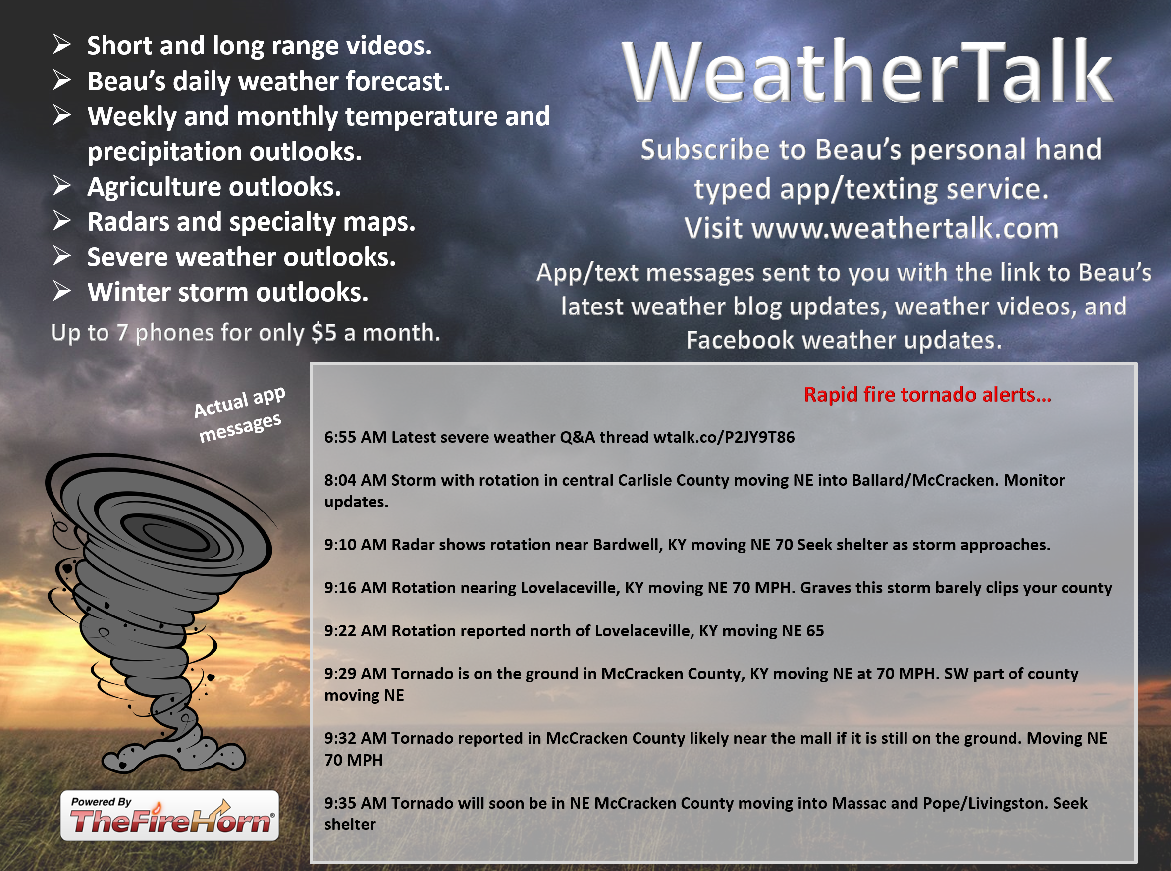
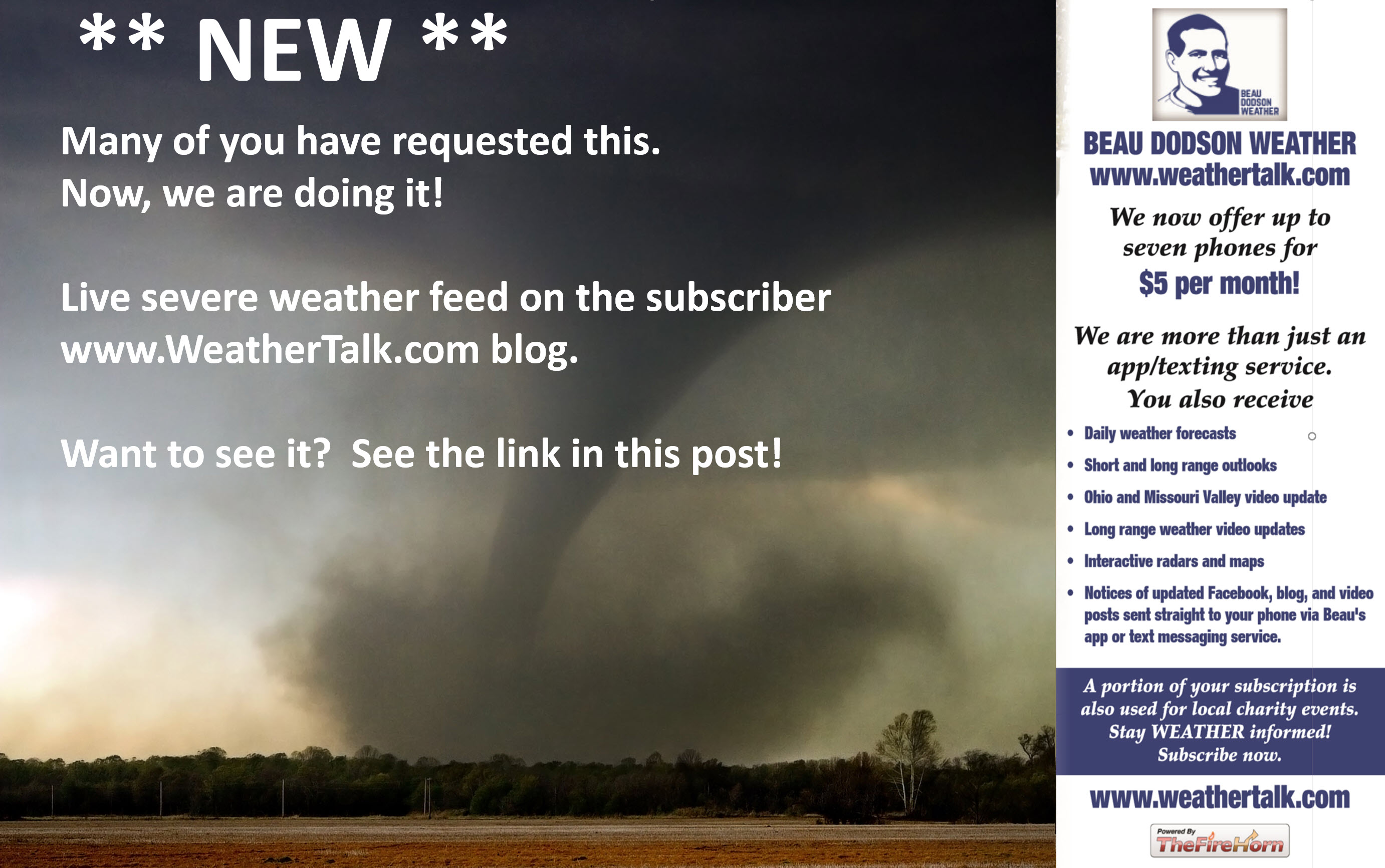
WeatherTalk monthly operating costs can top $4000.00. Your $5 subscription helps pay for those costs. I work for you.
The $5 will allow you to register up to seven phones!
For $5 a month you can receive the following. You may choose to receive these via your WeatherTalk app or regular text messaging.
Severe weather app/text alerts from my keyboard to your app/cell phone. These are hand typed messages from me to you. During tornado outbreaks, you will receive numerous app/text messages telling you exactly where the tornado is located.
.
- Daily forecast app/texts from my computer to your app/cell phone.
- Social media links sent directly to your app/cell phone. When I update the blog, videos, or Facebook you will receive the link.
- AWARE emails. These emails keep you well ahead of the storm. They give you several days of lead time before significant weather events.
- Direct access to Beau via text and email. Your very own personal meteorologist. I work for you!
- Missouri and Ohio Valley centered video updates
- Long-range weather videos
- Week one, two, three and four temperature and precipitation outlooks.
Monthly outlooks. - Your subscription also will help support several local charities.
.
Would you like to subscribe? Subscribe at www.beaudodsonweather.com

- Click one of the links below to take you directly to each section.
- Go to storm tracking tools. Radars, lightning, & satellite.
- Go to today’s forecast
- Go to the city-view graphic-casts
- Go to the severe weather outlook
- Go to the weather forecast discussion
- Go to the model future-cast radars
- Go to videos
- Go to weeks one, two, three, and four temperature & precipitation graphics
- Go to spring and summer outlooks.
- Go to Weatherbrains
- View our community charity work. Your subscription dollars help support these causes.
- County maps. I made a page with county maps. Some of you requested this.
Do you have questions or suggestions? If so, please email me. Beaudodson@usawx.com

Subscribe at www.weathertalk.com
.
Subscribers, PLEASE USE THE APP. ATT and Verizon are not reliable during severe weather. They are delaying text messages.
The app is under Beau Dodson Weather in the app store.

Apple users click here

Android users click here


Saturday: Monitor updates. Some storms are likely late Saturday afternoon and Saturday night. Some storms could be intense.
Sunday: Monitor updates. We will have thunderstorms on Sunday. Some could be intense.
Monday: No.
Tuesday: Monitor. Storms are possible.
Wednesday: Monitor. Storms may linger into Wednesday.
Thursday: No
Friday: No
Saturday: No
.

- Damp/wet ground conditions.
- River flooding continues in many areas. Low-land flooding.

Click here if you would like to return to the top of the page
.

Saturday through Monday
- Is lightning in the forecast? Yes. Lightning is likely late this afternoon over southeast Missouri. The lightning risk will spread eastward tonight into Sunday.
- Is severe weather in the forecast? Monitor updates. Intense storms are possible Saturday night into Sunday morning. A few storms could be severe. A few severe storms are possible Sunday afternoon over southern Illinois and perhaps portions of western Kentucky. Monitor updates.
* The NWS officially defines severe weather as 58 mph wind or great, 1″ hail or larger, and/or tornadoes - Is flash flooding in the forecast? Monitor. Storms will produce heavy rain. Isolated flooding issues may develop.
.

Tuesday through Saturday
- Is lightning in the forecast? Yes. Lightning is likely Tuesday and Tuesday night. Monitor Wednesday’s forecast.
- Is severe weather in the forecast? Monitor. A few storms could be intense on Tuesday, Tuesday night, and Wednesday. Monitor updates.
* The NWS officially defines severe weather as 58 mph wind or great, 1″ hail or larger, and/or tornadoes - Is flash flooding in the forecast? Low risk. I am monitoring Tuesday into Wednesday for locally heavy rain.
.

.
* The Missouri Bootheel includes Dunklin, New Madrid, and Pemiscot Counties
* Northwest Kentucky includes Daviess, Henderson, McLean Union, and Webster Counties
County Maps: Click Here
.
.
3. Look for the words LIVE LINK IS ACTIVE
.
Have there been any changes in the forecast over the last 24 hours?
I pushed up the arrival time of thunderstorms tonight.
.
What changes might occur in the forecast?
There are questions surrounding the Sunday afternoon forecast. Will storms redevelop? That will need to be closely monitored. Storms could be intense.
.
May 18, 2019
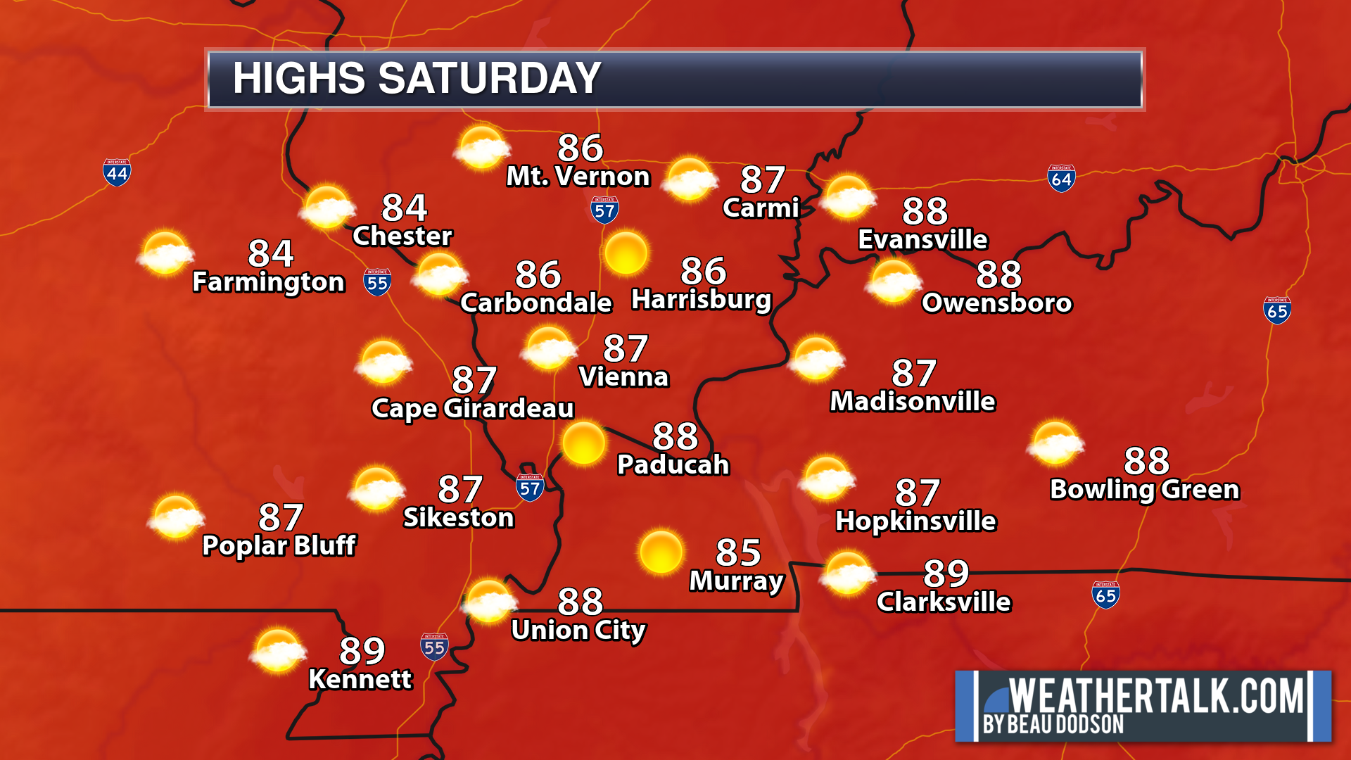
Saturday’s Forecast: Mostly sunny. Windy Some increase in clouds during the afternoon. A slight chance of thunderstorms before 6 PM as you move towards Poplar Bluff and the Bootheel of Missouri. Warm and humid.
My confidence in the forecast verifying: High (80% confidence in the forecast))
Temperature range: MO Bootheel 86° to 88° SE MO 84° to 88° South IL 84° to 86° Northwest KY (near Indiana border) 84° to 86° West KY 86° to 88° NW TN 86° to 88°
Wind direction and speed: South and southwest wind at 15 to 30 with gusts to 40 mph
Wind chill or heat index (feels like) temperature forecast: 88° to 94°
What is the chance/probability of precipitation? MO Bootheel 20% Southeast MO 20% IL 0% Northwest KY (near Indiana border) 0% Western KY 0% NW TN 0%
Note, what does the % chance actually mean? A 20% chance of rain does not mean it won’t rain. It simply means most areas will remain dry.
Coverage of precipitation: None for most of the area. A few late afternoon storms possible near Poplar Bluff and the Bootheel of Missouri.
What impacts are anticipated from the weather? Windy. A chance of lightning and heavy rain near Poplar Bluff and Missouri Bootheel late in the afternoon.
Should I cancel my outdoor plans? No, but check radars late in the day over southeast Missouri.
UV Index: 10 Very high
Sunrise: 5:44 AM
.
Saturday night Forecast: Showers and thunderstorms developing over southeast Missouri, southwest Illinois, far western Kentucky, and northwest Tennessee between 6 PM and midnight. Then, a chance of showers and thunderstorms area-wide after midnight. How far east the before midnight storms travel will need to be monitored. Some storms will produce frequent lightning, heavy rain, gusty winds, and a few could become severe.
My confidence in the forecast verifying: Medium (60% confidence in the forecast)
Temperature range: MO Bootheel 64° to 68° SE MO 64° to 68° South IL 64° to 68° Northwest KY (near Indiana border) 64° to 68° West KY 64° to 68° NW TN 65° to 70°
Wind direction and speed: South and southwest 8 to 16 mph and gusty.
Wind chill or heat index (feels like) temperature forecast: 65° to 70°
What is the chance/probability of precipitation? MO Bootheel 80% Southeast MO 80% IL 60% Northwest KY (near Indiana border) 60% Western KY 70% NW TN 70%
Note, what does the % chance actually mean? A 20% chance of rain does not mean it won’t rain. It simply means most areas will remain dry
Coverage of precipitation: Numerous
What impacts are anticipated from the weather? Heavy rain. Lightning. Some storms could produce high wind and hail, especially over southeast Missouri. Elsewhere, monitor.
Should I cancel my outdoor plans? Those with evening activities over southeast Missouri, southwest Illinois, far western Kentucky, and western Tennessee should monitor radars and updates.
Sunset: 8:00 PM
Moonrise: 7:56 PM
The phase of the moon: Full Moon
Moonset: 5:49 AM
.
.
May 19, 2019
Sunday’s Forecast: Morning clouds. Some scattered morning showers and thunderstorms are possible. Precipitation ending mid to late morning. A few storms may redevelop during the afternoon hours. Storms could locally be intense.
My confidence in the forecast verifying: Medium (50% confidence in the forecast))
Temperature range: MO Bootheel 78° to 82° SE MO 78° to 84° South IL 78° to 82° Northwest KY (near Indiana border) 78° to 82° West KY 78° to 82° NW TN 78° to 82°
Wind direction and speed: South and southwest wind at 15 to 30 mph and gusty.
Wind chill or heat index (feels like) temperature forecast: 80° to 84°
What is the chance/probability of precipitation? MO Bootheel 60% Southeast MO 60% IL 60% Northwest KY (near Indiana border) 60% Western KY 60% NW TN 60%
Note, what does the % chance actually mean? A 20% chance of rain does not mean it won’t rain. It simply means most areas will remain dry.
Coverage of precipitation: Most numerous during the morning hours. A few additional storms possible Sunday afternoon.
What impacts are anticipated from the weather? Some storms could be intense. Monitor updates. Lightning and gusty wind will be the main concern. I will monitor the hail and tornado threat.
Should I cancel my outdoor plans? Have a plan B and then monitor updates/radars.
UV Index: 6 to 7 High
Sunrise: 5:43 AM
.
Sunday night Forecast: Partly cloudy. An evening thunderstorm possible.
My confidence in the forecast verifying: Medium (60% confidence in the forecast)
Temperature range: MO Bootheel 54° to 58° SE MO 54° to 58° South IL 54° to 58° Northwest KY (near Indiana border) 54° to 58° West KY 54° to 58° NW TN 54° to 58°
Wind direction and speed: West and northwest at 6 to 12 mph
Wind chill or heat index (feels like) temperature forecast: 53° to 56°
What is the chance/probability of precipitation? MO Bootheel 10% Southeast MO 10% IL 30% Northwest KY (near Indiana border) 30% Western KY 30% NW TN 30%
Note, what does the % chance actually mean? A 20% chance of rain does not mean it won’t rain. It simply means most areas will remain dry
Coverage of precipitation: Ending from west to east. A few scattered thunderstorms
What impacts are anticipated from the weather? Some intense storms are possible early in the evening. This would mainly be over our eastern counties.
Should I cancel my outdoor plans? No, but monitor radars.
Sunset: 8:00 PM
Moonrise: 9:00 PM
The phase of the moon: Waning Gibbous
Moonset: 6:28 AM
.
.
May 20, 2019
Monday’s Forecast: Morning clouds with showers and thunderstorms. A lull in the rain. Warm and breezy. A chance of redevelopment Sunday afternoon. Some storms could be intense. Monitor updates.
My confidence in the forecast verifying: Medium (60% confidence in the forecast))
Temperature range: MO Bootheel 78° to 82° SE MO 74° to 78° South IL 74° to 78° Northwest KY (near Indiana border) 74° to 78° West KY 76° to 80° NW TN 78° to 82°
Wind direction and speed: North becoming east at 5 to 10 mph
Wind chill or heat index (feels like) temperature forecast: 74° to 78°
What is the chance/probability of precipitation? MO Bootheel 0% Southeast MO 0% IL 0% Northwest KY (near Indiana border) 0% Western KY 0% NW TN 0%
Note, what does the % chance actually mean? A 20% chance of rain does not mean it won’t rain. It simply means most areas will remain dry.
Coverage of precipitation: Most likely none
What impacts are anticipated from the weather? Most likely none
Should I cancel my outdoor plans? No
UV Index: 9 Very high
Sunrise: 5:42 AM
.
Monday night Forecast: A few evening clouds. Otherwise, mostly clear. Increasing clouds over southeast Missouri after midnight with a slight chance of a thunderstorm.
My confidence in the forecast verifying: Medium (60% confidence in the forecast)
Temperature range: MO Bootheel 58° to 62° SE MO 58° to 62° South IL 56° to 60° Northwest KY (near Indiana border) 56° to 60° West KY 55° to 60° NW TN 60° to 62°
Wind direction and speed: East at 6 to 12 mph
Wind chill or heat index (feels like) temperature forecast: 54° to 58°
What is the chance/probability of precipitation? MO Bootheel 10% Southeast MO 10% IL 10% Northwest KY (near Indiana border) 0% Western KY 0% NW TN 0%
Note, what does the % chance actually mean? A 20% chance of rain does not mean it won’t rain. It simply means most areas will remain dry
Coverage of precipitation: None over most of the area. Isolated after midnight over southeast Missouri.
What impacts are anticipated from the weather? None for most. Slight chance of lightning after midnight over southeast Missouri.
Should I cancel my outdoor plans? No
Sunset: 8:01 PM
Moonrise: 10:01 PM
The phase of the moon: Waning Gibbous
Moonset: 7:11 AM
.
Tuesday: Medium confidence. Partly to mostly cloudy with scattered showers and thunderstorms. Chance of storms will be 40% during the day and 60% at night. High temperatures in the lower to middle 80s. Low temperatures in the middle to upper 60s. South 10 to 20 mph.
.
Wednesday: Medium confidence. Partly cloudy with scattered showers and thunderstorms. Chance of storms will be 40% to 50% during the day and 30% at night. High temperatures in the middle 80s. Low temperatures in the middle to upper 60s. South winds at 10 to 20 mph and gusty.
.
Thursday: High confidence. Partly to mostly sunny. High temperatures in the middle to upper 80s. Low temperatures in the upper 60s. South winds at 7 to 14 mph
.
.
Learn more about the UV index readings. Click here.
.
.
Graphic-cast
.Click here if you would like to return to the top of the page
** These graphic-forecasts may vary a bit from my forecast above **
CAUTION: I have these graphics set to auto-update on their own. Make sure you read my hand-typed forecast above.
During active weather check my handwritten forecast.
.
Missouri


.
Illinois


.
Kentucky


.
Tennessee


.
This will be updated at 8 AM
.

The National Weather Service defines a severe thunderstorm as one that produces quarter size hail or larger, 58 mph winds or greater, and/or a tornado.
.
Saturday: Severe storms are not anticipated during the day. Thunderstorm chances will increase west to east tonight. Some storms could be severe over southeast Missouri. The risk is lower as you move east. We should all monitor updates tonight.
Sunday: Scattered storms are possible Sunday morning. A second round of scattered storms may develop during the afternoon. Monitor updates. A few storms could again be intense.
Monday: Severe storms are not anticipated.
Tuesday: Thunderstorms may again develop on Tuesday and Tuesday night. Monitor updates. Some storms could be intense.
Wednesday: Storms may linger into Wednesday although confidence is lower.
Thursday: Severe storms are not anticipated.
Friday: Severe storms are not anticipated.
.
Click here if you would like to return to the top of the page
.
Numerous value-added severe weather graphics.
Click to enlarge
Subscribe at www.weathertalk.com
.
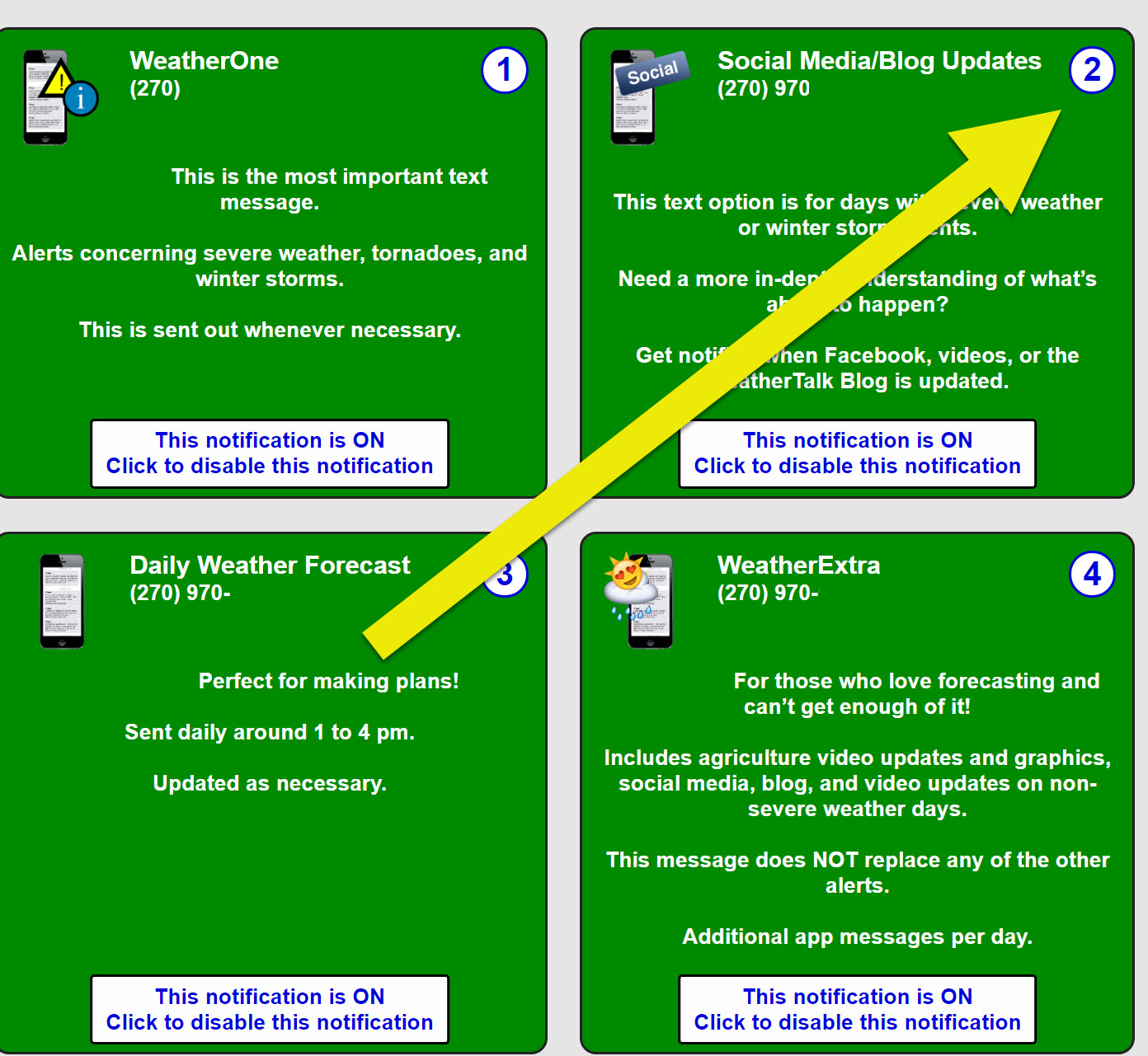
Be sure and have WeatherOne turned on in your WeatherTalk accounts. That is the one for winter storms, ice storms, and severe weather.
Log into your www.weathertalk.com
Click the personal notification settings tab.
Turn on WeatherOne. Green is on. Red is off.

.

Here is the latest graphic from the WPC/NOAA.
.
24-hour precipitation outlook.
.

.
Here is the seven-day precipitation forecast. This includes day one through seven.

- Warm and windy today.
- Increasing chances of showers and thunderstorms this evening into Sunday.
- Another round of storms Tuesday and Wednesday.
.
Current conditions.

.
Click here if you would like to return to the top of the page
.
 .
.
May temperature and precipitation outlook
Subscribe at www.weathertalk.com
Precipitation
Subscribe at www.weathertalk.com
.
![]()
.
Storm Tracking Links

Radar Link: Interactive local city-view radars & regional radars.
You will find clickable warning and advisory buttons on the local city-view radars.
If the radar is not updating then try another one. If a radar does not appear to be refreshing then hit Ctrl F5. You may also try restarting your browser.
Not working? Email me at beaudodson@usawx.com
National map of weather watches and warnings. Click here.
Storm Prediction Center. Click here.
Weather Prediction Center. Click here.
I will likely start the live blog feed later today and will keep it going overnight (if severe storms form or are possible).
What is the live feed?
.
3. Look for the words LIVE LINK IS ACTIVE
First, we have strong and gusty winds today. These are gradient winds. What are gradient winds? These winds are considered non-thunderstorm winds. They are produced by rising and falling barometric pressure readings. They are also caused by strong low level winds aloft. These winds can be tapped into and brought down to the surface.
Winds of 20 to 40 mph will be possible today.
High temperatures today will top out in the 85 to 90-degree range! Dew points will be in the 60s. It will feel warm and humid.
.
Thunderstorm outlook.
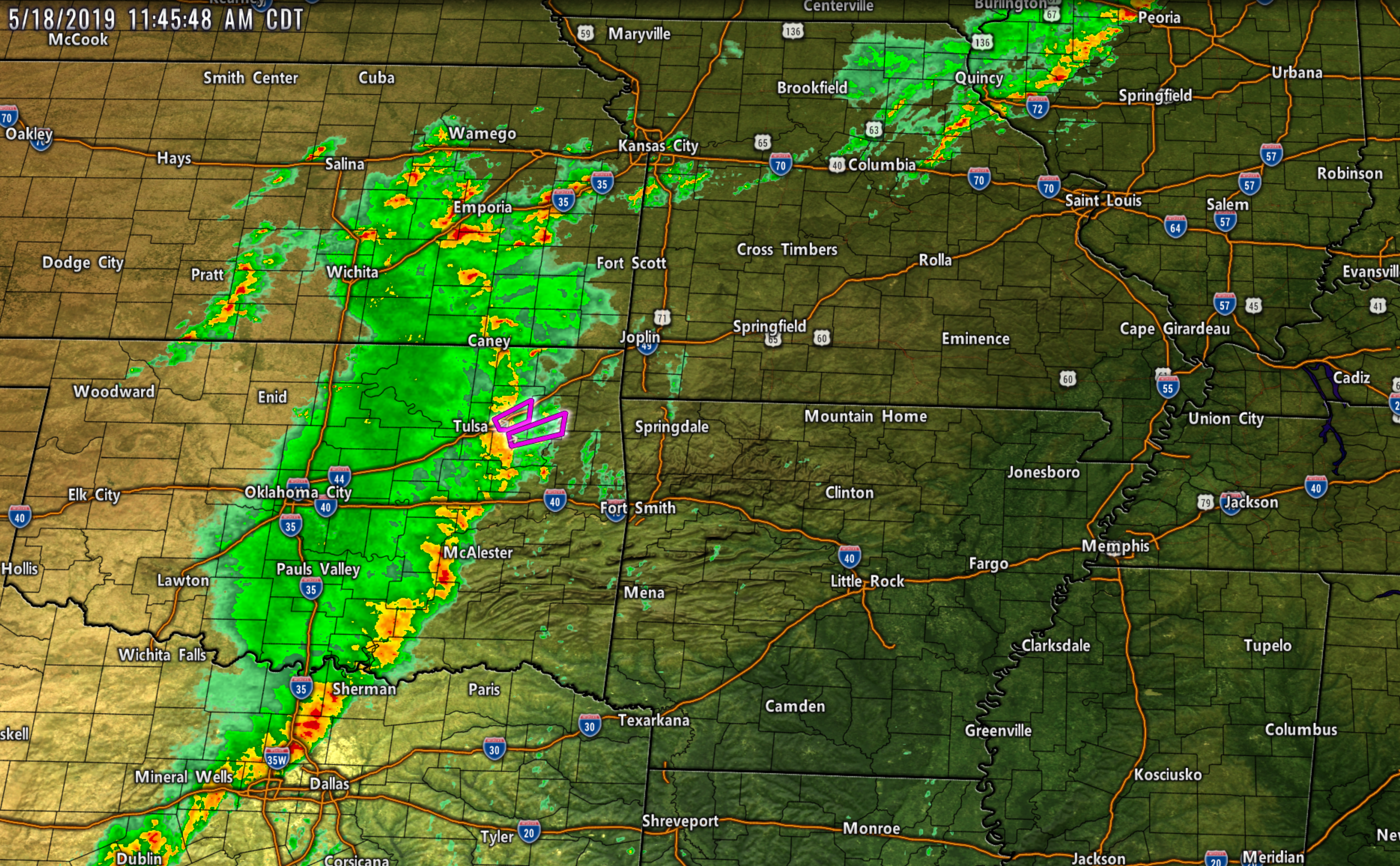
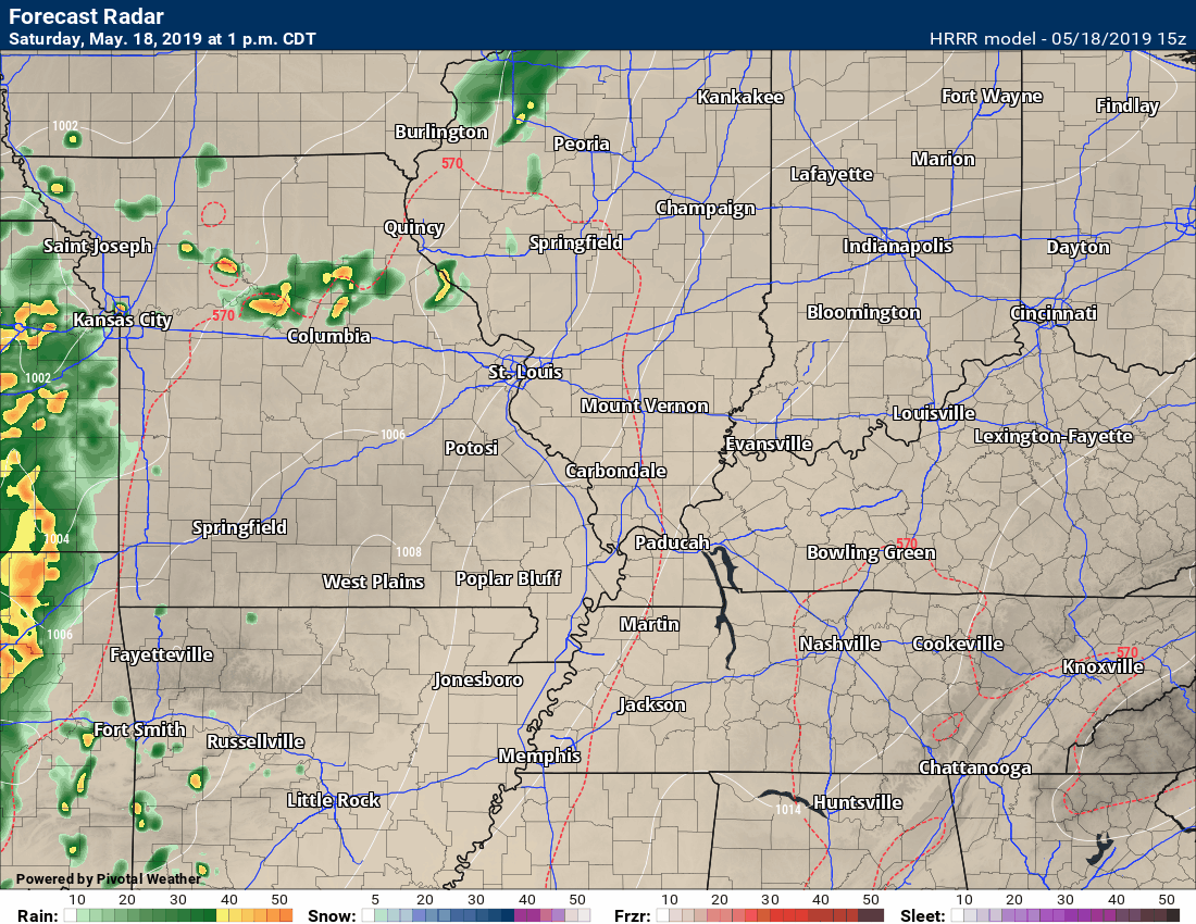
As of this typing (12:20 PM), the weather radar looked like this.
You can see a line of showers and thunderstorms in Kansas, Oklahoma, and Texas.
This line of thunderstorms will continue to move east/northeast into the afternoon and evening hours.
There is a chance that some of the storms could be severe as they move into our western counties. Our western counties would be near Poplar Bluff and down into the Bootheel.
Whether storms remain severe (as they move further east) is still a question.
The Storm Prediction Center (see above) has outlined portions of our region for a risk of severe weather later today and tonight.
Remember, a watch means to monitor updates. A WARNING means to seek shelter. A warning means to take action.
The best advice is to go about your business and monitor updated radars and forecasts.
Click images to enlarge them.
.
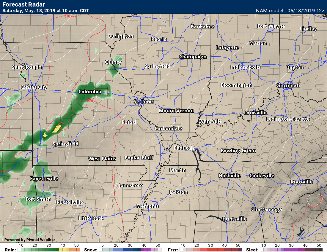
As you can see, future-cast radars have mixed ideas on how much of this activity survives into the overnight hours. See the future-cast radars below.
In addition to this initial round of showers and thunderstorms, we may have another band or two of showers and storms form after midnight.
All of this muddles tomorrow morning’s forecast.
If we have widespread clouds and shower/storm activity before tomorrow afternoon then the risk of severe weather decreases tomorrow afternoon.
At this point, it is something I am monitoring. The best advice is to monitor updates tomorrow. I will, of course, be sending out app notifications.
Monday now appears to be shaping up dry. That dry weather should last into Monday night.
Another system moves into the region on Tuesday and Tuesday night. This system will produce additional showers and thunderstorms Tuesday into Wednesday. Some of those storms could be intense. Thus, monitor updates.
We are in peak tornado season. Of course, we can have tornadoes year-round. We typically see a peak in April, May, and June. Then again in late October and November.
There will be some spin in the atmosphere over the next 24 to 36 hours. Thus, monitor updated information.
 .
.
Click here if you would like to return to the top of the page
.
Again, as a reminder, these are models. They are never 100% accurate. Take the general idea from them.
.
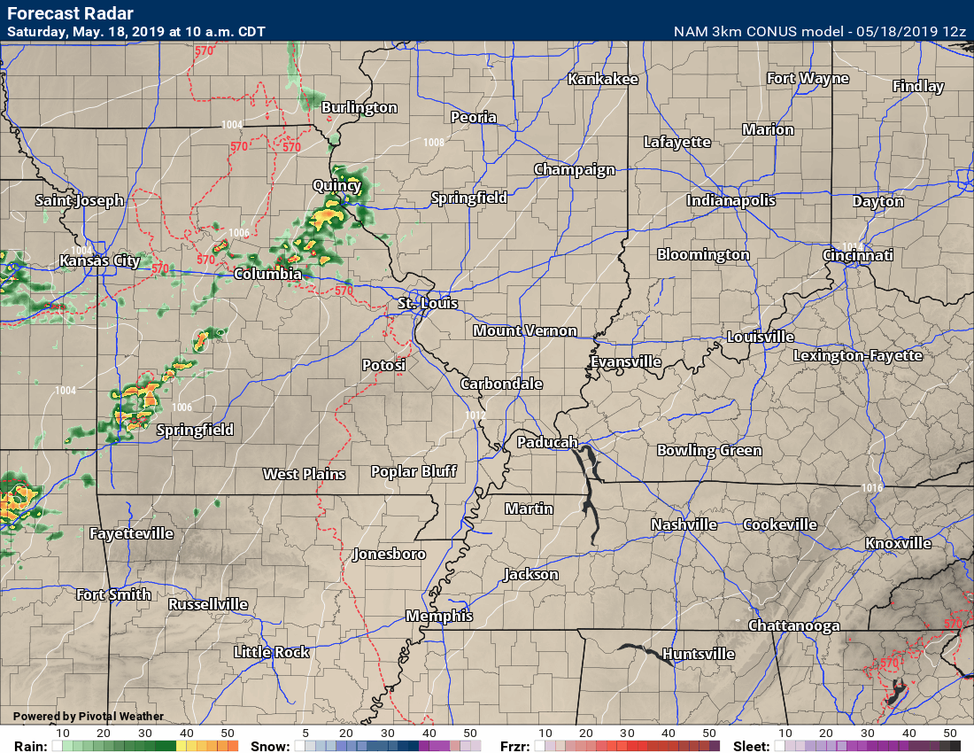
Here is the lower resolution NAM model and then the higher resolution NAM 3K below it.
Timestamp upper left.
Click the animations to enlarge them.
.
Click the animations to enlarge them.
.
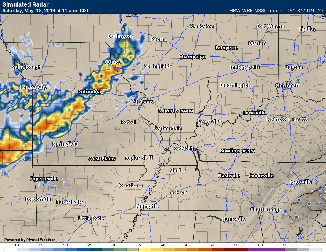
Here is the high-resolution WRF model guidance.
Click the animations to enlarge them.
.
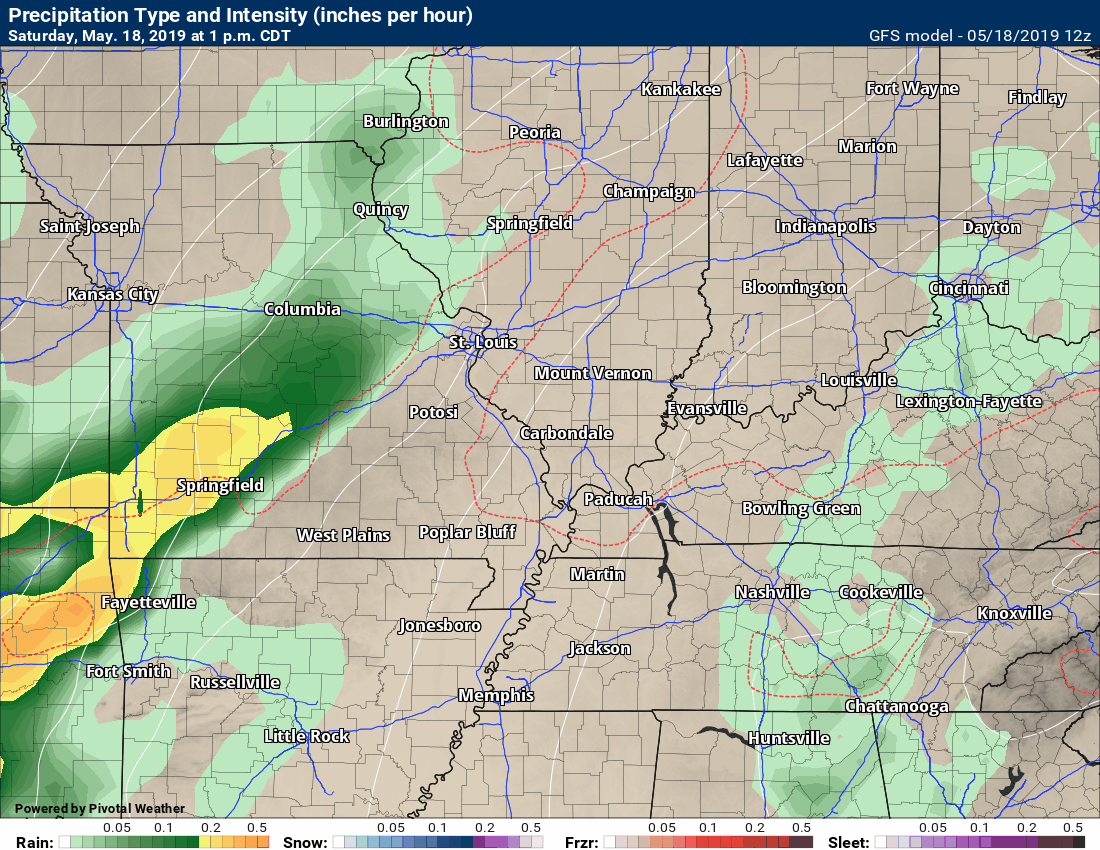
Here is the high-resolution Hrrr model guidance.
Click the animations to enlarge them.
.
Looking even further out. The GFS is a long-range model.
The GFS model is a lower resolution model. It makes the rain coverage appear larger.
The models above are higher resolution models.
Timestamp upper left. Click the animation to enlarge it.
.
These maps update several times a day. Occasionally, in between updates, you may see a duplicate day or one out of sync.
Forty-eight-hour temperature outlook.


.
.

Click here if you would like to return to the top of the page
These are bonus videos.
I pay BAMwx to help with videos.
They do not currently have a Kentucky/Tennessee specific video.
This product is for subscribers of WeatherTalk
Subscribe at www.weathertalk.com
The Ohio Valley video
.

This product is for subscribers of WeatherTalk
Subscribe at www.weathertalk.com


This product is for subscribers of WeatherTalk
Subscribe at www.weathertalk.com
.

This product is for subscribers of WeatherTalk
Subscribe at www.weathertalk.com
.
This product is for subscribers of WeatherTalk
Subscribe at www.weathertalk.com
.
Precipitation outlook
This product is for subscribers of WeatherTalk
Subscribe at www.weathertalk.com
.
Preliminary summer outlook
This product is for subscribers of WeatherTalk
Subscribe at www.weathertalk.com
.
.
Radar Link: Interactive local city-view radars & regional radars.
You will find clickable warning and advisory buttons on the local city-view radars.
If the radar is not updating then try another one. If a radar does not appear to be refreshing then hit Ctrl F5. You may also try restarting your browser.
Not working? Email me at beaudodson@usawx.com
National map of weather watches and warnings. Click here.
Storm Prediction Center. Click here.
Weather Prediction Center. Click here.
.

Live lightning data: Click here.
.

Interactive GOES R satellite. Track clouds. Click here.
GOES 16 slider tool. Click here.
College of Dupage satellites. Click here
.

Here are the latest local river stage forecast numbers Click Here.
Here are the latest lake stage forecast numbers for Kentucky Lake and Lake Barkley Click Here.
.
Did you know that you can find me on Twitter? Click here to view my Twitter weather account.

.
Not receiving app/text messages?
- Make sure you have the correct app/text options turned on. Do that under the personal notification settings tab at www.weathertalk.com. Red is off. Green is on.
- USE THE APP. Verizon and ATT have been throttling text messages. The app receives the same messages instantly. Texts can take longer. Please, use the app. It is under Beau Dodson Weather in the app stores.


WeatherBrains Episode 693
.
Tonight’s guest WeatherBrain is the Warning Coordination Meteorologist at the NWS Office in Memphis, TN. He is a 31-year veteran of the NWS, and worked at offices in west Texas, north Texas, and Phoenix AZ before moving to Memphis. He received his Bachelors Degree in Meteorology from Florida State, and his Masters from the University of Oklahoma. He has focused on severe storms and storm spotter training throughout his career, and has helped develop spotter training materials that were and are used nationwide. Gary Woodall, welcome to WeatherBrains!
Tonight’s second guest WeatherBrain is a graduating senior from the University of Oklahoma’s School of Meteorology. She is Oklahoma Weather Labs Director of Operations and a Senior Representative to the OU School of Meteorology Student Affairs Committee. Also, she is Deputy Director of the New Student Mentoring Program and a member of the OU Nightly Weather Team. Leah Hill, welcome to WeatherBrains!
Other discussions in this weekly podcast include topics like:
- What role does social media play in severe weather events?
- How should the NWS word severe weather warnings and statements?
- POD/FAR emphasis
- Issues with the general public not being able to find themselves on a map
- The Astronomy Report from Tony Rice
- and more!
.
.
Previous episodes can be viewed by clicking here.
.
Find Beau on Facebook! Click the banner.

.
Find Beau on Twitter! Share your weather photos! @beaudodson

.
Click here to go to the top of the page
Did you know that a portion of your monthly subscription helps support local charity projects? Not a subscriber? Becoming one at www.weathertalk.com
You can learn more about those projects by visiting the Shadow Angel Foundation website and the Beau Dodson News website.
