
.

.
I have some question-and-answer threads over on the Facebook page. Link to those threads CLICK HERE
Or email me at beaudodsonweather@gmail.com
.
I will be off work tomorrow. I have a medical and travel day. The next blog update will be on Tuesday.
.

.

🌪️ Seven-Day Tornado Outlook ⛈️
March 9th through March 15th.
Current risk: POSSIBLE. Friday into Saturday. I will fine-tune the timing over the coming days.
Current confidence level: LOW. The event is still several days away.
Comment: My primary concern is a system that arrives on Friday and Saturday. Some of the thunderstorms could be severe. It is still a bit early for certainties and details. Thus, monitor updates over the coming days. The Storm Prediction Center/NOAA has already outlined our region for a risk. See below.
.
.
Seven-Day Hazardous Weather Outlook
1. Is lightning in the forecast? YES. A few storms are possible from Wednesday afternoon into Thursday. Thunderstorms are likely on Friday and Saturday.
2. Are severe thunderstorms in the forecast? POSSIBLE. A few thunderstorms on Wednesday PM/Thursday could produce pea to dime-size hail (that is sub-severe).
Severe thunderstorms are possible on Friday and Saturday. Perhaps centered on Friday night. This event is several days away. Monitor updates.
3. Is flash flooding in the forecast? NOT AT THIS TIME. Some data shows a flash flood risk on Friday night/Saturday. Confidence in that scenario is low. For now, the system might be too progressive to produce widespread issues. I am closely monitoring it. If the system slows down, then the flash flood risk will increase.
4. Will non-thunderstorm winds top 40 mph? MONITOR. Gusty winds are possible on Friday and Saturday. Similar to last week’s wind event.
5. Will temperatures drop below 10 degrees? NO.
6. Will the wind chill dip below 0 degrees? NO.
7. Is measurable snow and/or sleet in the forecast? NO.
8. Is freezing rain/ice in the forecast? NO.
.
A quick forecast glance. Your 48-hour forecast Graphics


.

.


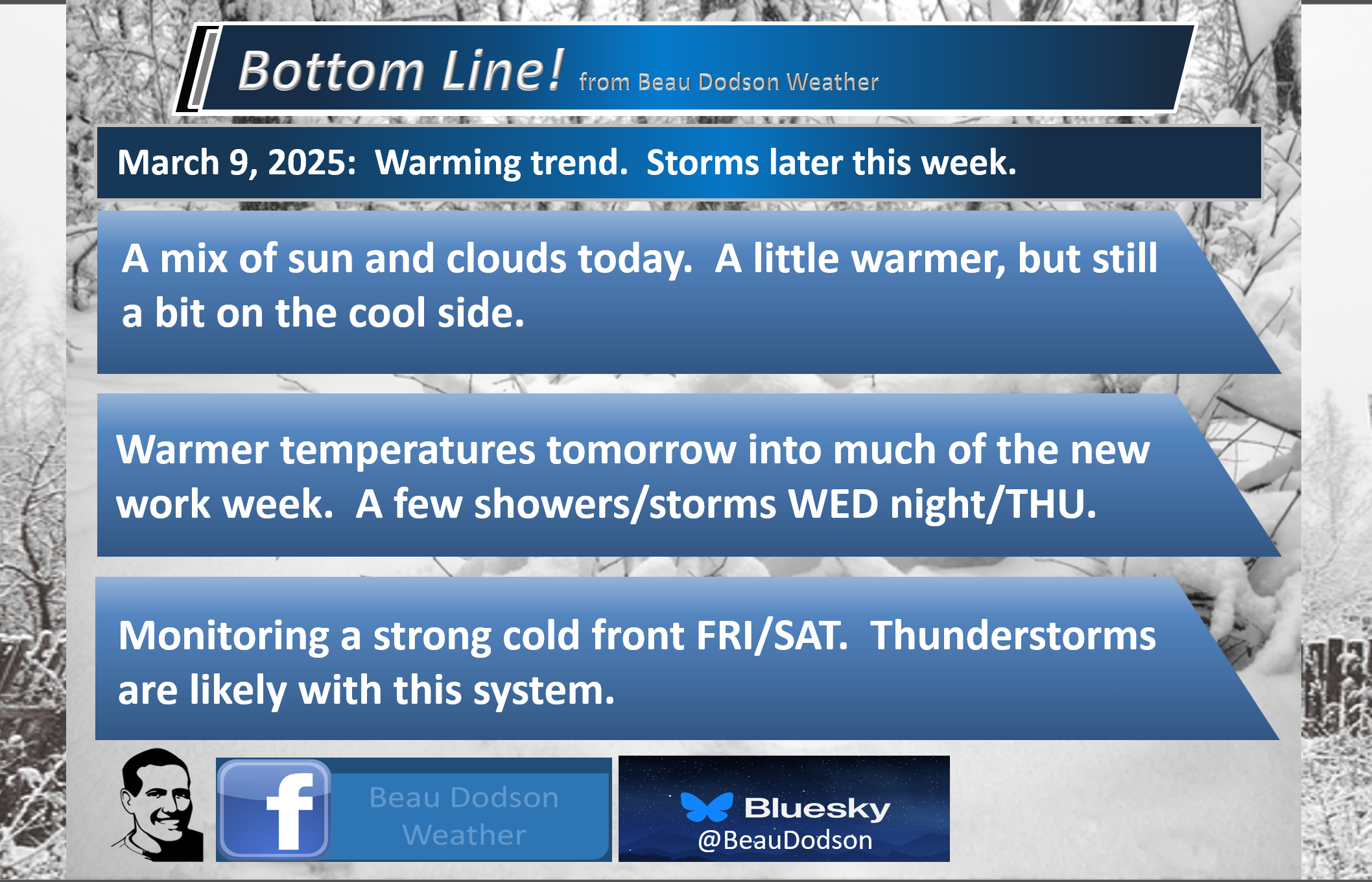
Forecast discussion.
- A mix of sun and clouds today. Clearing as we move through the day (for those waking up to clouds).
- A warming trend tomorrow into much of the new work week.
- A few showers and thunderstorms on Wednesday afternoon into Thursday.
- A stronger system arrives on Friday and Saturday. Thunderstorms are likely with that system. Some could be intense.
.

.
Good morning, everyone.
Monday is a travel day for me. I will be off from work.
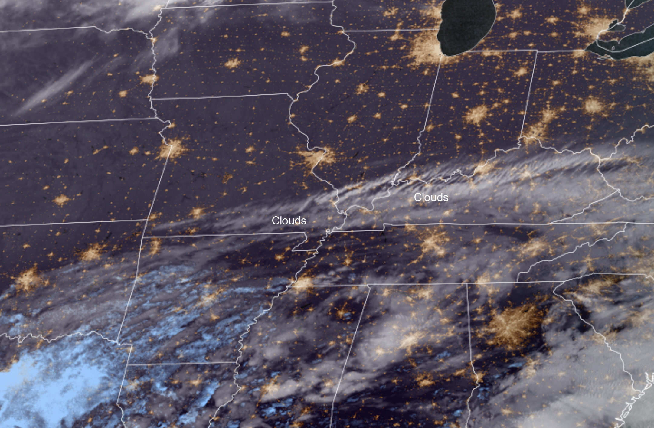
We have some clouds in the region this morning.
You can see those on the NOAA satellite. Sunshine north and south of those clouds.
.
The clouds should clear as we move through the day.
It will be cool today. High temperatures will mostly be in the 50s.
It will be warmer tomorrow into much of the new work week. Tomorrow’s highs will rise into the 60s. That will feel nice.
We will see temperatures in the 70s this week! Especially from Tuesday to Friday.
Friday could even deliver temperatures in the mid to upper 70s! That will occur ahead of a strong cold front. Strong southerly winds will push warm, moist air northward.
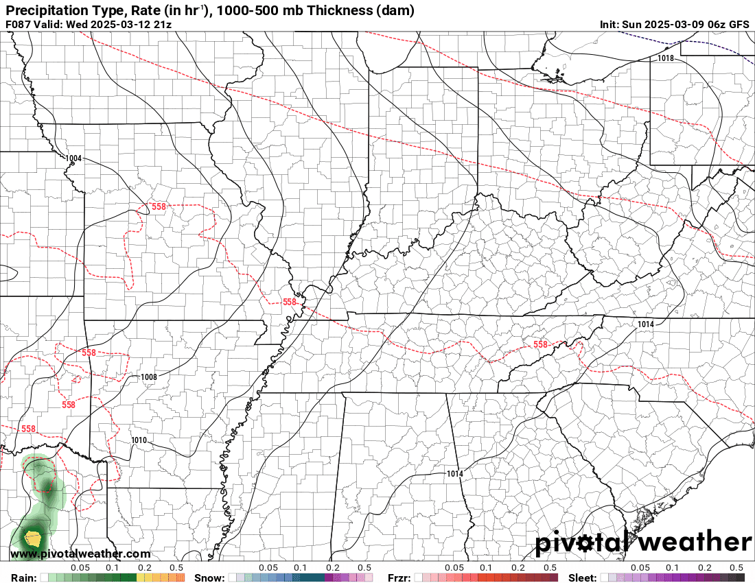
A weak system will pass through our region on Wednesday and Thursday. This will bring a few showers and thunderstorms. The primary concern with thunderstorms is lightning, and a few reports of dime-sized hail. We are currently not expecting severe weather.
Here is the future-cast radar for the mid-week event. Double-click the animation to enlarge it.
.
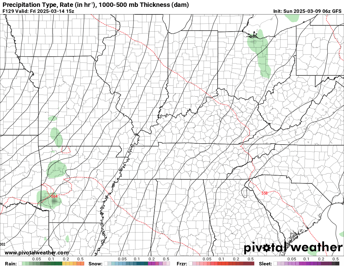
A much stronger storm system will develop on Friday and Saturday. This will be one to watch.
That system will be a blizzard across portions of the plains. It will bring widespread showers and thunderstorms to our region. We can’t rule out severe weather, but since it is still six days away, confidence in the magnitude of severe weather remains low.
This system has plenty of moisture to work with. Higher dew points than the last system. There is more instability than in the previous system. Very strong wind fields aloft. That means strong wind shear. All of those ingredients are a concern when it comes to severe weather.
Here is the GFS model showing the late-week system.
.
I can’t rule out severe thunderstorms.
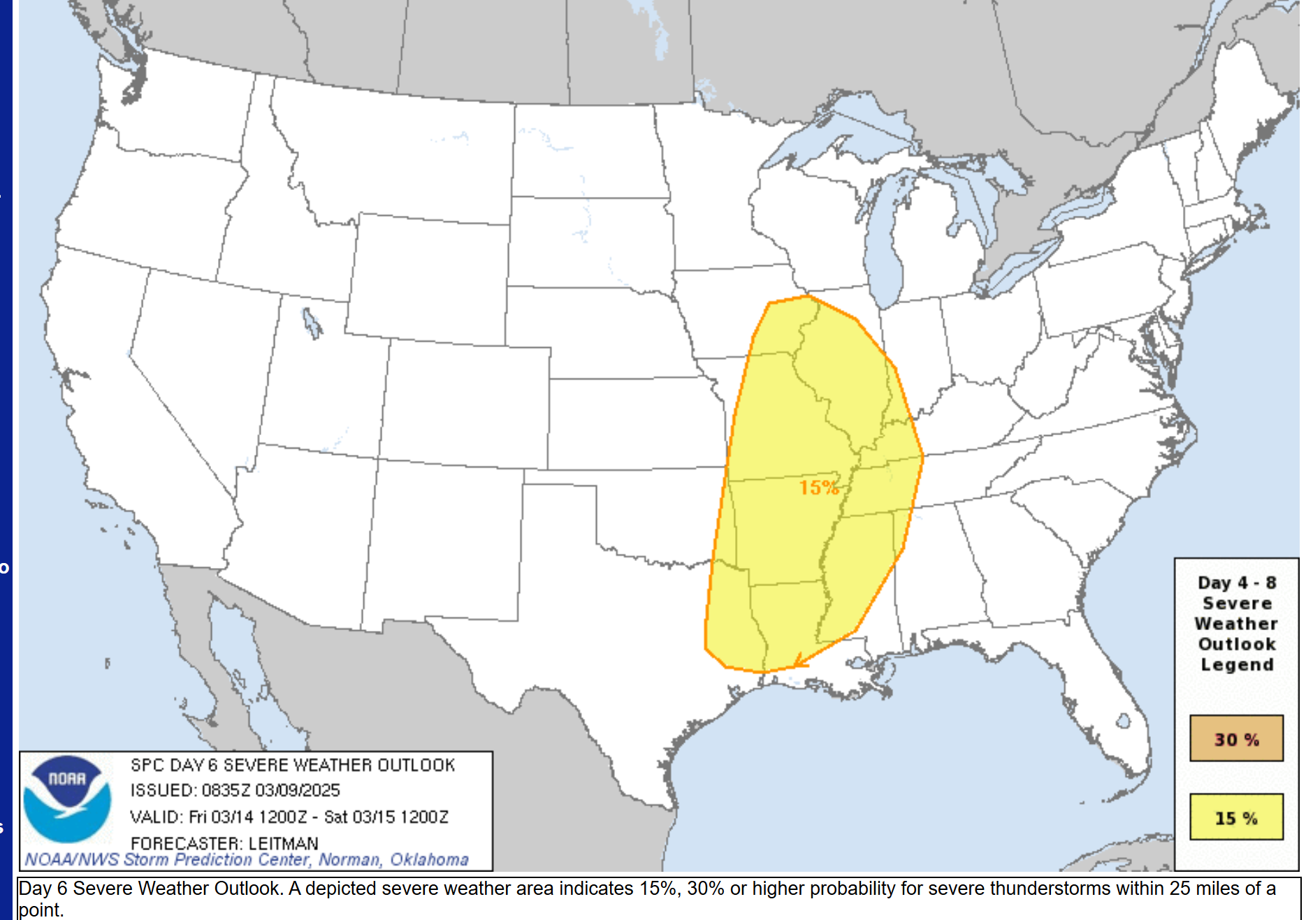
The Storm Prediction Center/NOAA has already outlined our region for a risk of severe weather on Friday afternoon into Saturday morning.
A rather large area. Extending from Iowa to Texas and Louisiana. Confidence in severe weather with this event is higher than the last one. Remember, in the previous event, the SPC had us at risk, as well. The severe weather during that event was mostly to our south.
Here is the severe weather outlook for the Friday/Saturday event.
.
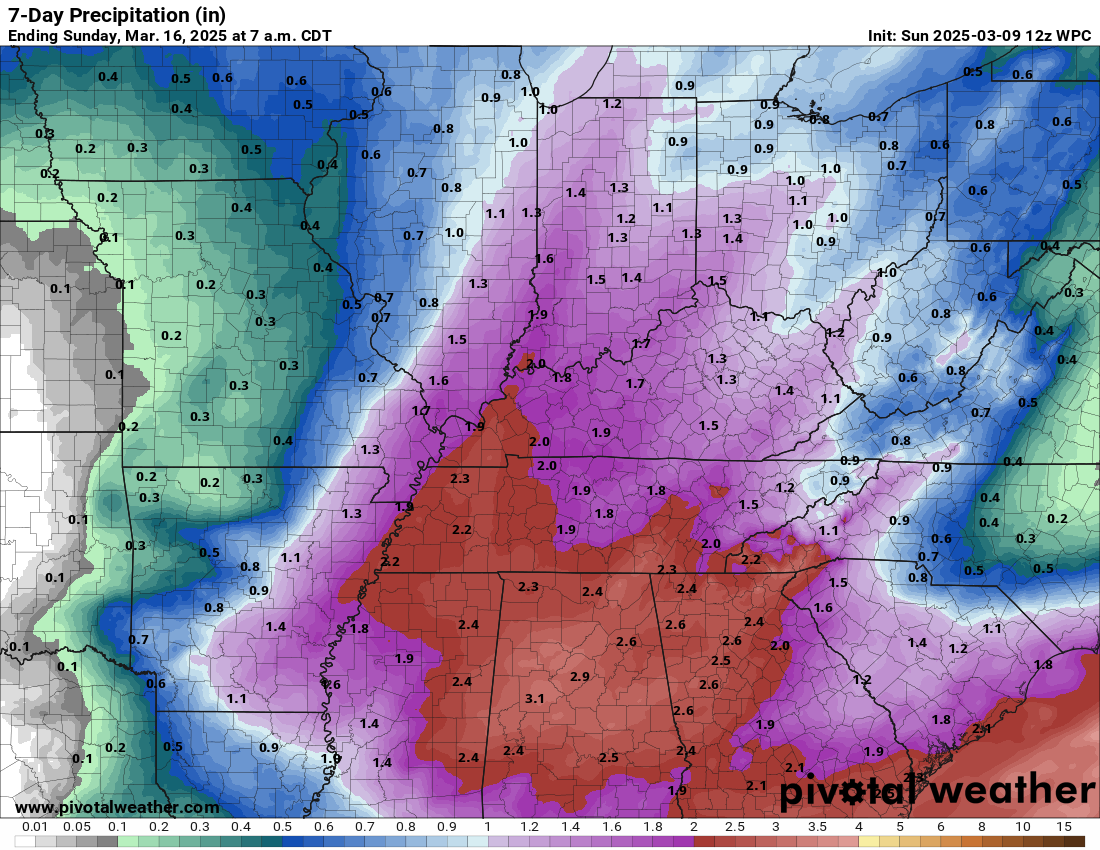
Rainfall amounts from that system could be locally heavy. Some data slows the front. If that happens, then rainfall totals will be higher. Double-click on this image to enlarge it.
Most of this would fall on Friday afternoon into Saturday morning. That is my current forecast.
.
I will be closely monitoring that weekend system. I will know quite a bit more as we move through the week.
Monitor updates. Make sure you have three to five ways of receiving severe weather information.
Your Beau Dodson Weather app is one of those ways.
Don’t forget that I have partnered with Weather Call, as well.
They will call your phone when you are in a warning. This is great for overnight tornado outbreaks.
.
.

Here is the Hrrr future-cast radar.
Double-click the animation to enlarge it.
The timestamp (upper left) is in Zulu. 12z=6 am. 18z=12 pm. 00z=6 pm.
\
.
.
.
.

Radars and Lightning Data
Interactive-city-view radars. Clickable watches and warnings.
https://wtalk.co/B3XHASFZ
Old legacy radar site (some of you like it better)
https://weatherobservatory.com/weather-radar.htm
If the radar is not updating then try another one. If a radar does not appear to be refreshing then hit Ctrl F5. You may also try restarting your browser.
Backup radar site in case the above one is not working.
https://weathertalk.com/morani
Regional Radar
https://imagery.weathertalk.com/prx/RadarLoop.mp4
** NEW ** Zoom radar with chaser tracking abilities!
ZoomRadar
If the radar is not working, then email me: Email me at beaudodson@usawx.com
.
We do have some sponsors! Check them out.
Connected and Protected.
They Specialize in Audio, Video, Networking, Security, Cameras, Electrical, New Construction, Remodels, and retrofitting Jobs. Experience the future of smart living and unmatched security with Connected & Protected Solutions today.
Link – Click here

.
Roof damage from recent storms? Link – Click here
INTEGRITY ROOFING AND EXTERIORS!
⛈️ Roof or gutter damage from recent storms? Today’s weather is sponsored by Integrity Roofing. Check out their website at this link https://www.ourintegritymatters.com/

![]()
![]()

.
Click here if you would like to return to the top of the page.
.Average high temperatures for this time of the year are around 50 degrees.
Average low temperatures for this time of the year are around 30 degrees.
Average precipitation during this time period ranges from 0.90″ to 1.20″
Six to Ten Day Outlook.
Blue is below average. Red is above average. The no color zone represents equal chances.
Average highs for this time of the year are in the lower 60s. Average lows for this time of the year are in the lower 40s.

Green is above average precipitation. Yellow and brown favors below average precipitation. Average precipitation for this time of the year is around one inch per week.

.

Average low temperatures for this time of the year are around 31degrees.
Average precipitation during this time period ranges from 0.90″ to 1.20″
.
Eight to Fourteen Day Outlook.
Blue is below average. Red is above average. The no color zone represents equal chances.

Green is above average precipitation. Yellow and brown favors below average precipitation. Average precipitation for this time of the year is around one inch per week.

.
![]()
Make sure you have three to five ways of receiving your severe weather information.
Weather Talk is one of those ways! Now, I have another product for you and your family.

.
.
https://weathercallservices.com/beau-dodson-weather


Want to add more products to your Beau Dodson Weather App?
Receive daily videos, weather blog updates on normal weather days and severe weather and winter storm days, your county by county weather forecast, and more!
Here is how to do add those additional products to your app notification settings!
Here is a video on how to update your Beau Dodson Weather payment.
The app is for subscribers. Subscribe at www.weathertalk.com/welcome then go to your app store and search for WeatherTalk
Subscribers, PLEASE USE THE APP. ATT and Verizon are not reliable during severe weather. They are delaying text messages.
The app is under WeatherTalk in the app store.

Apple users click here

Android users click here
.
Radars and Lightning Data
Interactive-city-view radars. Clickable watches and warnings.
https://wtalk.co/B3XHASFZ
Old legacy radar site (some of you like it better)
https://weatherobservatory.com/weather-radar.htm
If the radar is not updating then try another one. If a radar does not appear to be refreshing then hit Ctrl F5. You may also try restarting your browser.
Backup radar site in case the above one is not working.
https://weathertalk.com/morani
Regional Radar
https://imagery.weathertalk.com/prx/RadarLoop.mp4
** NEW ** Zoom radar with chaser tracking abilities!
ZoomRadar
Lightning Data (zoom in and out of your local area)
https://wtalk.co/WJ3SN5UZ
Not working? Email me at beaudodson@usawx.com
National map of weather watches and warnings. Click here.
Storm Prediction Center. Click here.
Weather Prediction Center. Click here.
.

Live lightning data: Click here.
Real time lightning data (another one) https://map.blitzortung.org/#5.02/37.95/-86.99
Our new Zoom radar with storm chases
.
.

Interactive GOES R satellite. Track clouds. Click here.
GOES 16 slider tool. Click here.
College of DuPage satellites. Click here
.

Here are the latest local river stage forecast numbers Click Here.
Here are the latest lake stage forecast numbers for Kentucky Lake and Lake Barkley Click Here.
.
.
Find Beau on Facebook! Click the banner.


 .
.