
.

.
I have some question-and-answer threads over on the Facebook page. Link to those threads CLICK HERE
Or email me at beaudodsonweather@gmail.com
.

Seven-Day Tornado Outlook ⛈️
March 7th through March 13th.
RISK LEVEL: MONITOR.
Confidence: LOW.
Comment: I am watching a system around the 13th and another one around the 15th. It is too soon to know if severe weather will be a concern. Monitor updates.
.
.
Seven-Day Hazardous Weather Outlook
1. Is lightning in the forecast? POSSIBLE. I am monitoring next Wednesday, Thursday, and Friday/Saturday.
2. Are severe thunderstorms in the forecast? MONITOR. I am monitoring next Wednesday and Thursday. I am watching another system next Friday and Saturday.
3. Is flash flooding in the forecast? NO.
4. Will non-thunderstorm winds top 40 mph? NO.
5. Will temperatures drop below 10 degrees? NO.
6. Will the wind chill dip below 0 degrees? NO.
7. Is measurable snow and/or sleet in the forecast? NO.
8. Is freezing rain/ice in the forecast? NO.
.
A quick forecast glance. Your 48-hour forecast Graphics


.

.


Forecast discussion.
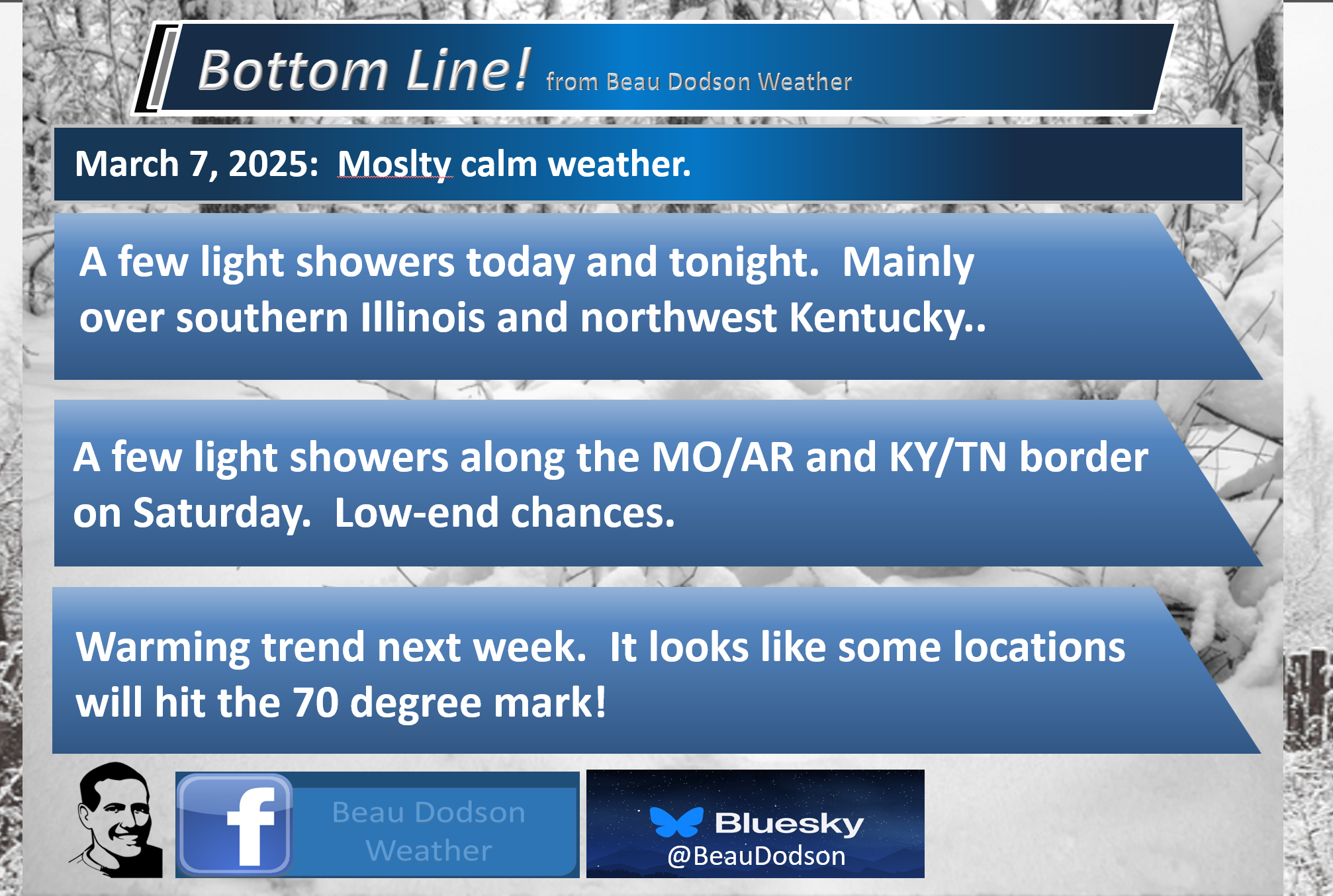
- A few light showers in the region today and tomorrow. A mix of sun and clouds today and tomorrow.
- Warmer next week.
- Monitoring the chance of showers and thunderstorms next Wednesday and Thursday.
- I’m watching a bigger system around the 15th.
.

Good morning, everyone!
A week cold front will push into the region today with clouds and isolated showers. Gusty winds, at times.
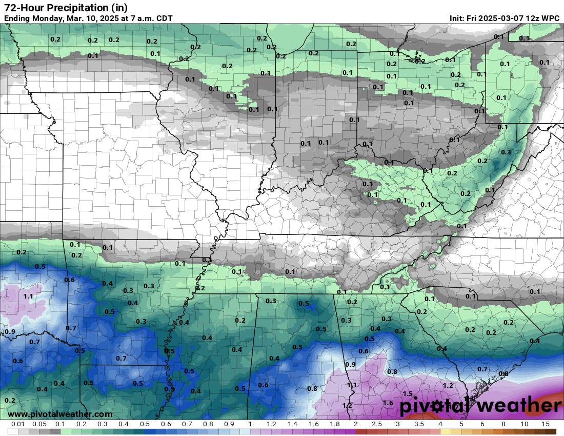
Peak rain chances will be across southern Illinois and northwest Kentucky. Rainfall totals of 0.00″ to 0.10″ are anticipated. Many areas may remain dry.
The official rainfall forecast shows very little.
.
This front does not have a lot of moisture to work with.
A few showers are possible along the MO/AR and KY/TN border on Saturday, as well. Anything that does fall will be light. I have low-end rain chances. A mix of sun and clouds today into tomorrow.
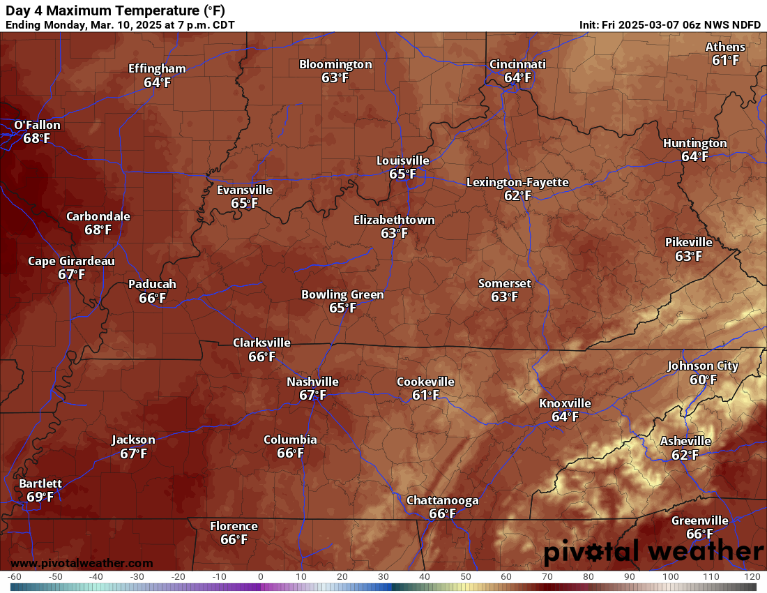
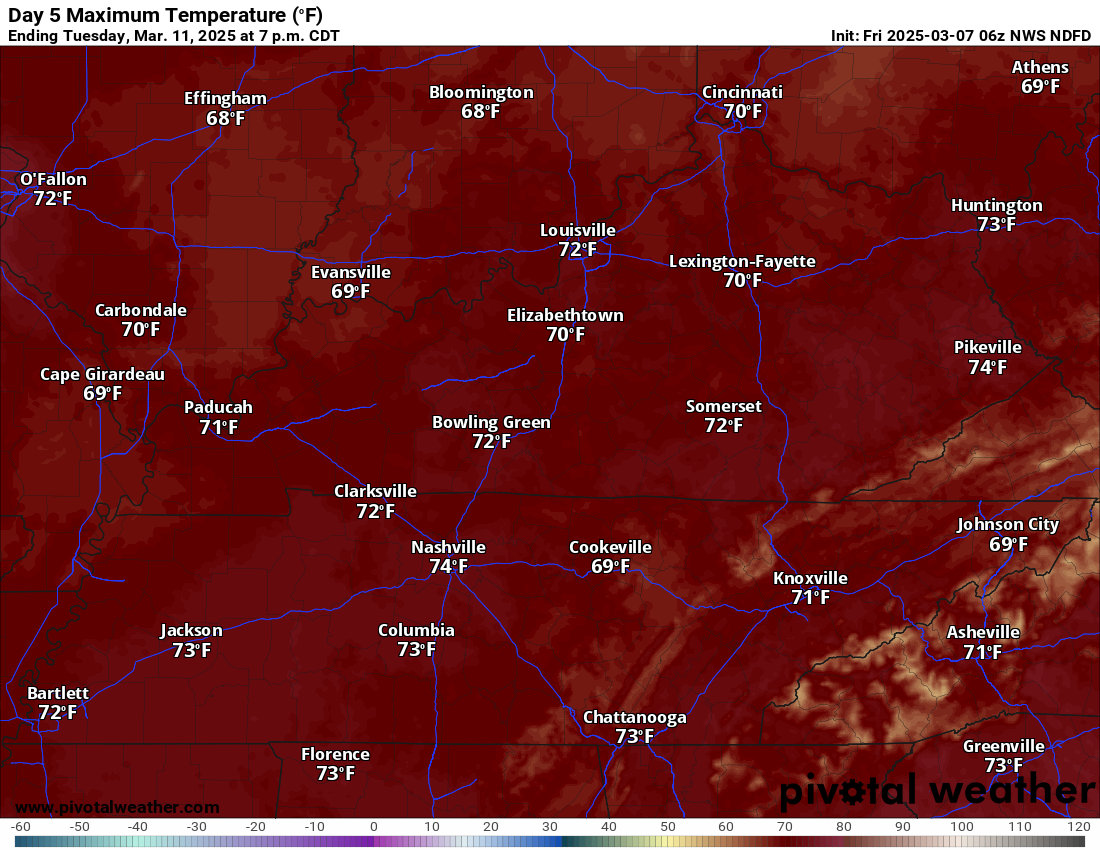
A slow warming trend begins on Sunday, which will take us into next week.
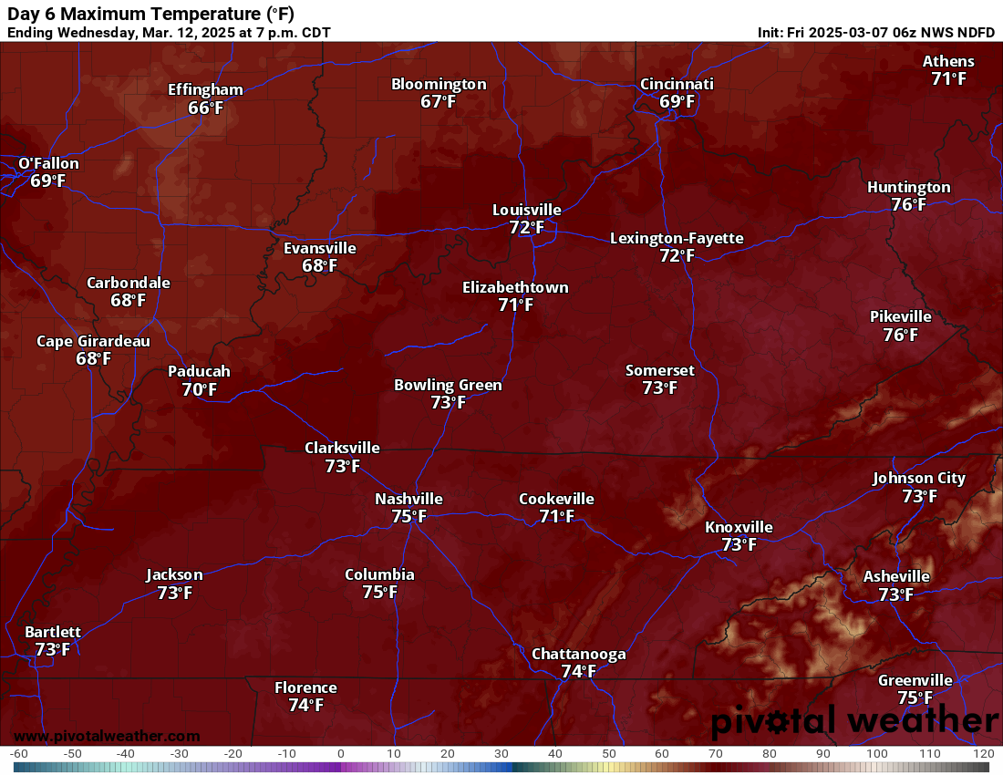
As a matter of fact, a few 70s are possible as early as Tuesday! A few showers by Wednesday.
Monday high temperatures

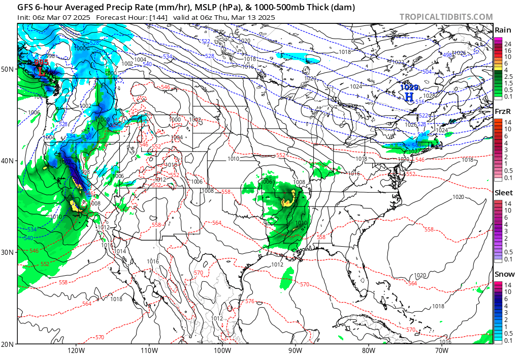
.I am watching another system next Wednesday and Thursday. Another one next weekend (around the 15th). The one next Wednesday may pass just to our south. There remain questions on the track.The Wednesday/Thursday low-pressure center could pass just to our south. Severe weather will not be a concern if the low tracks to our south.
.
The one on the 15th/16th looks like another windbag with gusty winds and rapidly falling and rising barometric pressure.
The one around the 15th will have a deep area of low pressure. The low will pass to our north, placing us in the warm sector. We will need to monitor the risk of storms. It’s too soon to know if severe weather is a concern.
If it occludes too fast, the severe weather threat will be minimal. Similar to the system we just experienced (with the gust winds).
Occluded fronts usually indicate that the parent weather system has reached its mature stage and is decaying (decreasing in intensity).
Those black lines are isobars. Isobars are equal lines of Barometric pressure. When they are tightly packed together, then gust winds are usually the result.
I will be monitoring it.

Stay tuned.
.

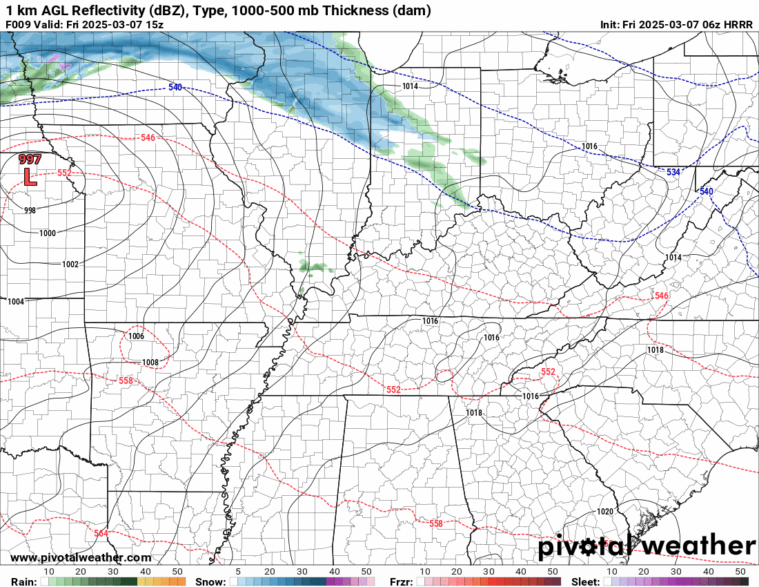
Here is the Hrrr future-cast radar.
Double-click the animation to enlarge it.
The timestamp (upper left) is in Zulu. 12z=6 am. 18z=12 pm. 00z=6 pm.
\
.
.
.
.

Radars and Lightning Data
Interactive-city-view radars. Clickable watches and warnings.
https://wtalk.co/B3XHASFZ
Old legacy radar site (some of you like it better)
https://weatherobservatory.com/weather-radar.htm
If the radar is not updating then try another one. If a radar does not appear to be refreshing then hit Ctrl F5. You may also try restarting your browser.
Backup radar site in case the above one is not working.
https://weathertalk.com/morani
Regional Radar
https://imagery.weathertalk.com/prx/RadarLoop.mp4
** NEW ** Zoom radar with chaser tracking abilities!
ZoomRadar
If the radar is not working, then email me: Email me at beaudodson@usawx.com
.
We do have some sponsors! Check them out.
Connected and Protected.
They Specialize in Audio, Video, Networking, Security, Cameras, Electrical, New Construction, Remodels, and retrofitting Jobs. Experience the future of smart living and unmatched security with Connected & Protected Solutions today.
Link – Click here

.
Roof damage from recent storms? Link – Click here
INTEGRITY ROOFING AND EXTERIORS!
⛈️ Roof or gutter damage from recent storms? Today’s weather is sponsored by Integrity Roofing. Check out their website at this link https://www.ourintegritymatters.com/

![]()
![]()

.
Click here if you would like to return to the top of the page.
.Average high temperatures for this time of the year are around 50 degrees.
Average low temperatures for this time of the year are around 30 degrees.
Average precipitation during this time period ranges from 0.90″ to 1.20″
Six to Ten Day Outlook.
Blue is below average. Red is above average. The no color zone represents equal chances.
Average highs for this time of the year are in the lower 60s. Average lows for this time of the year are in the lower 40s.

Green is above average precipitation. Yellow and brown favors below average precipitation. Average precipitation for this time of the year is around one inch per week.

.

Average low temperatures for this time of the year are around 31degrees.
Average precipitation during this time period ranges from 0.90″ to 1.20″
.
Eight to Fourteen Day Outlook.
Blue is below average. Red is above average. The no color zone represents equal chances.

Green is above average precipitation. Yellow and brown favors below average precipitation. Average precipitation for this time of the year is around one inch per week.

.
![]()
Make sure you have three to five ways of receiving your severe weather information.
Weather Talk is one of those ways! Now, I have another product for you and your family.

.
.
https://weathercallservices.com/beau-dodson-weather


Want to add more products to your Beau Dodson Weather App?
Receive daily videos, weather blog updates on normal weather days and severe weather and winter storm days, your county by county weather forecast, and more!
Here is how to do add those additional products to your app notification settings!
Here is a video on how to update your Beau Dodson Weather payment.
The app is for subscribers. Subscribe at www.weathertalk.com/welcome then go to your app store and search for WeatherTalk
Subscribers, PLEASE USE THE APP. ATT and Verizon are not reliable during severe weather. They are delaying text messages.
The app is under WeatherTalk in the app store.

Apple users click here

Android users click here
.
Radars and Lightning Data
Interactive-city-view radars. Clickable watches and warnings.
https://wtalk.co/B3XHASFZ
Old legacy radar site (some of you like it better)
https://weatherobservatory.com/weather-radar.htm
If the radar is not updating then try another one. If a radar does not appear to be refreshing then hit Ctrl F5. You may also try restarting your browser.
Backup radar site in case the above one is not working.
https://weathertalk.com/morani
Regional Radar
https://imagery.weathertalk.com/prx/RadarLoop.mp4
** NEW ** Zoom radar with chaser tracking abilities!
ZoomRadar
Lightning Data (zoom in and out of your local area)
https://wtalk.co/WJ3SN5UZ
Not working? Email me at beaudodson@usawx.com
National map of weather watches and warnings. Click here.
Storm Prediction Center. Click here.
Weather Prediction Center. Click here.
.

Live lightning data: Click here.
Real time lightning data (another one) https://map.blitzortung.org/#5.02/37.95/-86.99
Our new Zoom radar with storm chases
.
.

Interactive GOES R satellite. Track clouds. Click here.
GOES 16 slider tool. Click here.
College of DuPage satellites. Click here
.

Here are the latest local river stage forecast numbers Click Here.
Here are the latest lake stage forecast numbers for Kentucky Lake and Lake Barkley Click Here.
.
.
Find Beau on Facebook! Click the banner.


 .
.