

Radars and Lightning Data
Interactive-city-view radars. Clickable watches and warnings.
https://wtalk.co/B3XHASFZ
Old legacy radar site (some of you like it better)
https://weatherobservatory.com/weather-radar.htm
If the radar is not updating then try another one. If a radar does not appear to be refreshing then hit Ctrl F5. You may also try restarting your browser.
Backup radar site in case the above one is not working.
https://weathertalk.com/morani
Regional Radar
https://imagery.weathertalk.com/prx/RadarLoop.mp4
Zoom National Radar
ZoomRadar
.

.
I have some question-and-answer threads over on the Facebook page. Link to those threads CLICK HERE
Or email me at beaudodsonweather@gmail.com
.

🌪️ Seven-Day Tornado Outlook ⛈️
March 28th through April 4th
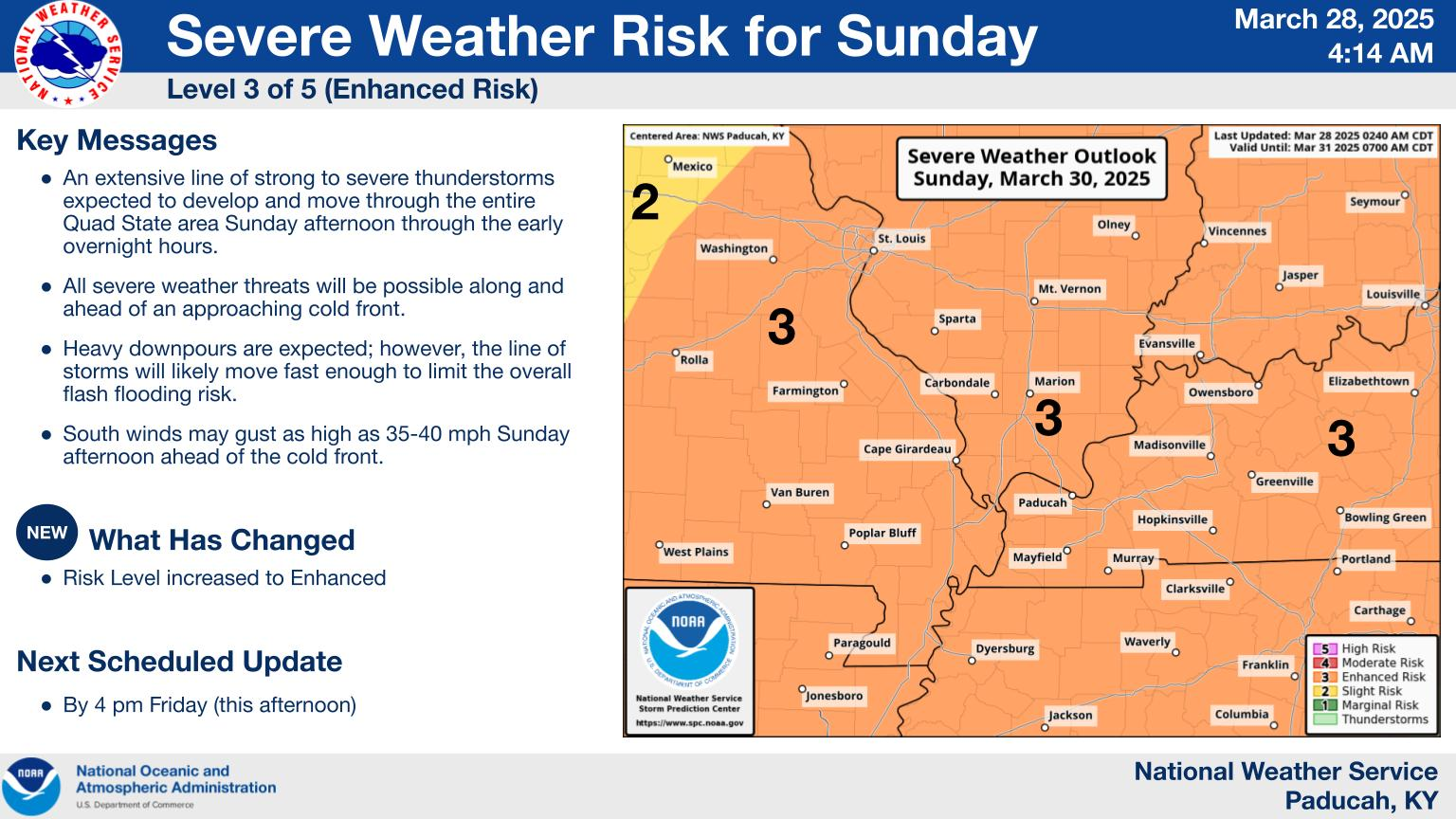
Current risk: YES. There is a risk of tornadoes on Sunday afternoon and Sunday night. I am monitoring next Wednesday and Wednesday night. I am monitoring Sunday 12 PM to Monday 2 AM. Perhaps centered on 3 PM to 2 AM. I will fine-tune the timing as fresh data arrives today.
Current confidence level: MEDIUM.
Comment: Data continues to increase the risk of severe weather on Sunday. Confidence is increasing that our region will experience severe thunderstorms with very large hail, damaging wind, and even tornadoes.
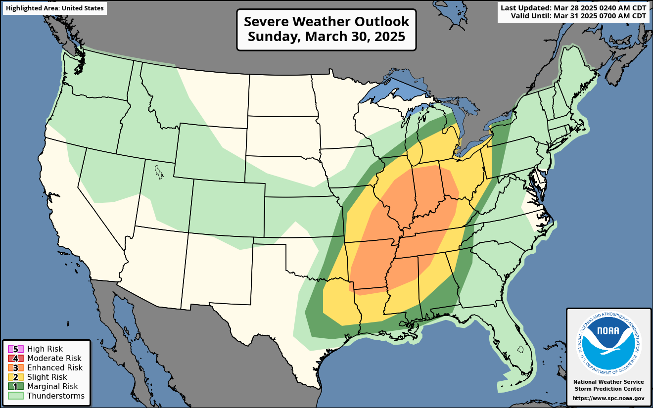
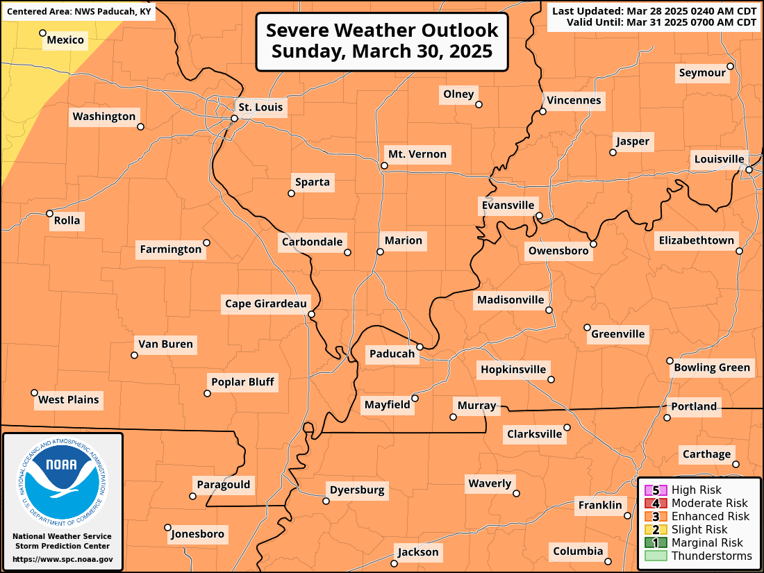
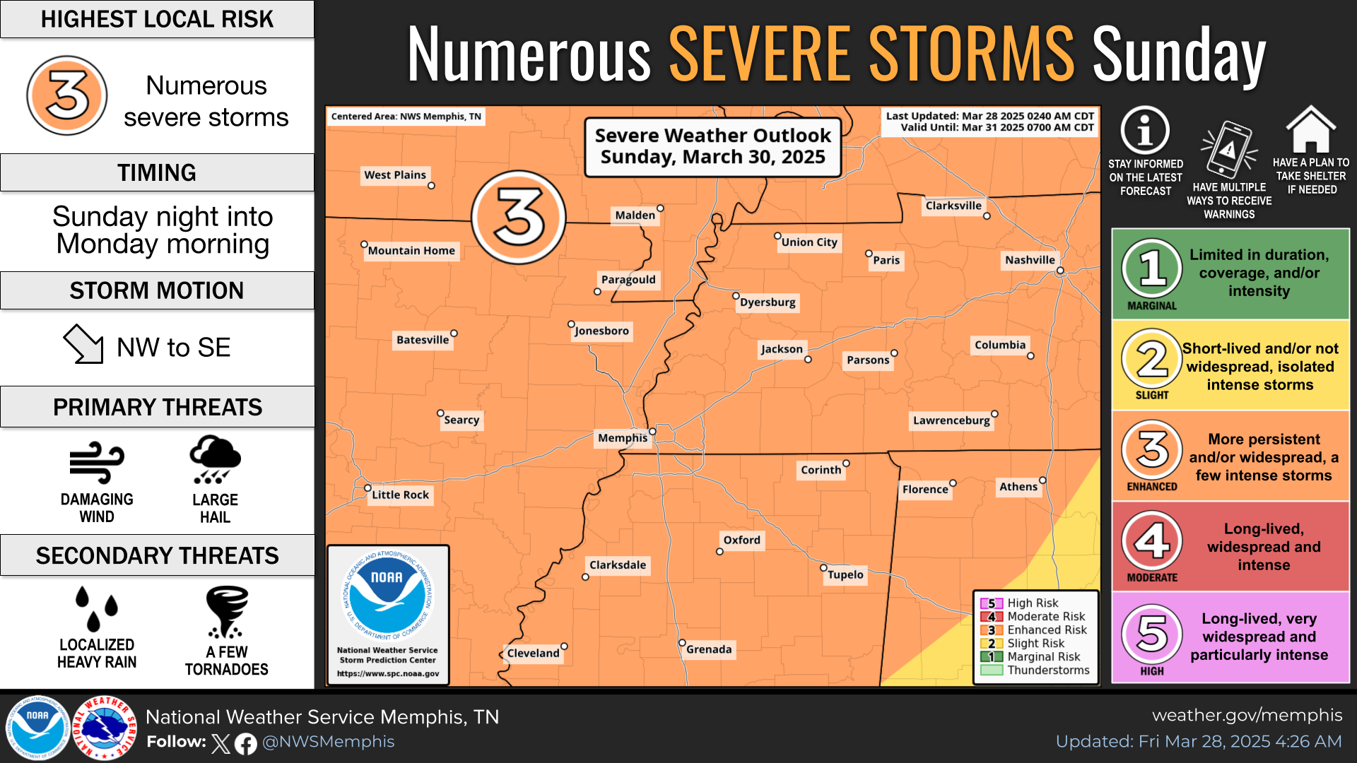
The Storm Prediction Center has outlined a large level three severe weather risk zone.
If you have outdoor plans on Sunday, then monitor the latest forecasts.
.
All of our region is in a level three risk. The levels range from one to five. Five being the highest.
.
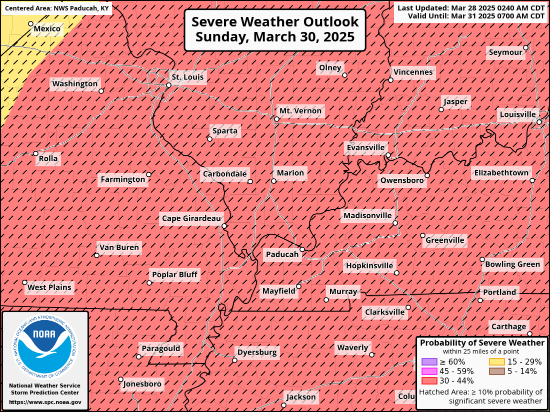
The red-hatched zone means significant severe weather is possible.
Golf ball+ size hail, 70 mph wind gusts, and even a tornado.
.
From the Paducah, Kentucky, NWS (NOAA)
.
This is from the Memphis, Tennessee, NWS (NOAA)
.

Seven-Day Hazardous Weather Outlook
1. Is lightning in the forecast? YES. Lightning is possible from Friday night into Sunday night. Another chance next Wednesday.
2. Are severe thunderstorms in the forecast? YES. There is a risk of severe weather on Sunday afternoon and night. Another risk arrives next Wednesday.
3. Is flash flooding in the forecast? LOW RISK. Some isolated issues are possible on Sunday. I will monitor next Wednesday.
4. Will non-thunderstorm winds top 40 mph? NO.
5. Will temperatures rise above 90 degrees? NO.
6. Will the heat index rise above 100 degrees? NO.
.
A quick forecast glance. Your 48-hour forecast Graphics


.

.


Forecast discussion.
- Mild temperatures through Sunday. Gusty winds. Cooler temperatures on Monday and Tuesday.
- A few sprinkles today. A mix of sun and clouds.
- Increasing chances of showers and thunderstorms tonight into Saturday. Have a plan B if you have outdoor activities.
- Severe thunderstorms are likely Sunday afternoon and night. Be weather-aware.
- Another chance of severe weather next Wednedsay.
.

.
Good morning, everyone.
The primary topic is the severe weather event on Sunday.
First, we will have a mix of sun and clouds today. Isolated light showers are possible. Warm and windy. Winds may gust above 30 mph from time to time.
Shower chances ramp up late tonight.
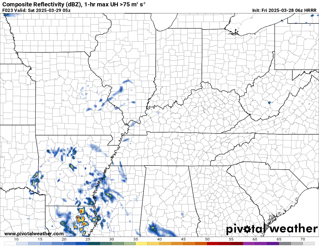
Widespread showers and thunderstorms are anticipated on Saturday. If you have outdoor plans, then monitor the weather radars. Have a plan B.
It may not rain all day in one spot, but there will be rain on the radars most of the day. A few non-severe thunderstorms, as well.
.

The timestamp (upper left) is in Zulu. 12z=6 am. 18z=12 pm. 00z=6 pm.
Double-click the animation to enlarge it.
This is the Hrrr model. This shows you the Saturday showers and thunderstorms.
Double-click the animation to enlarge it.
.
Severe Weather Concerns Are Increasing on Sunday afternoon and night
We are now within 48 to 72 hours of this severe weather event. I am ramping up the language.
Make sure you have three or more ways of receiving severe weather information.
There remain some questions about wind fields on Sunday, but the overall forecast continues to ramp up concerns.
The ingredients appear to be coming together for a risk of large hail, damaging wind, and tornadoes.
Some of the hail could reach golf ball size or larger. Wind gusts above 70 mph are possible, as well. There will also be a tornado risk.
The Storm Prediction Center (NOAA) has increased our risk to level three. It could rise to a level four. Either way, severe thunderstorms are likely on Sunday afternoon and night.
I am monitoring Sunday 12 PM to Monday 2 AM. Perhaps centered on 3 PM to 2 AM. I will fine-tune the timing as fresh data arrives today.
Be prepared Sunday afternoon and night for severe weather.
Review your storm safety plans with your family. Then, monitor updates.
Rainfall totals through Monday. Thunderstorms can enhance rain totals.
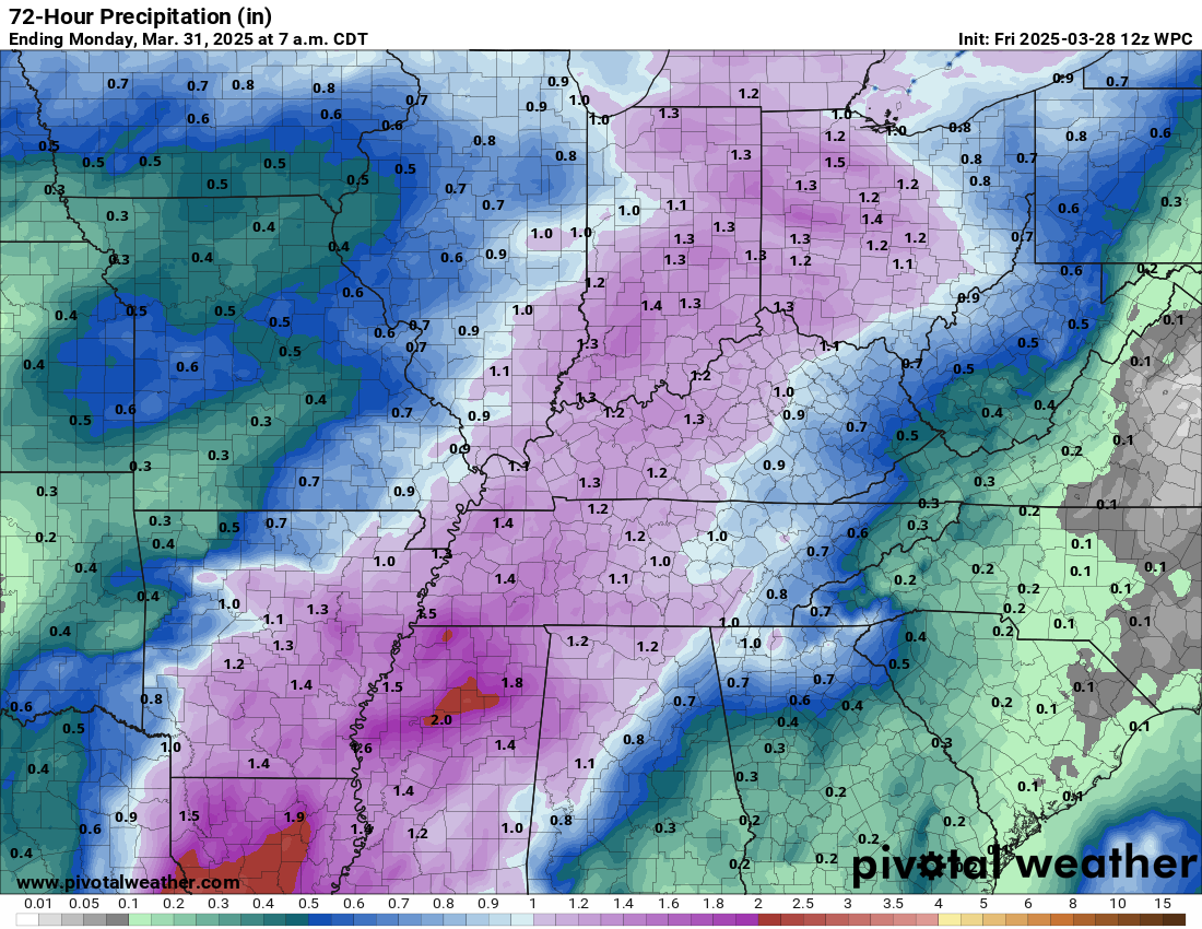
Another round of storms will likely impact the region next Wednesday. I can’t rule out severe thunderstorms. Let’s worry about that after we get past Sunday’s event.
Monitor updates.

.
Click here if you would like to return to the top of the page.
.Average high temperatures for this time of the year are around 62 degrees.
Average low temperatures for this time of the year are around 40 degrees.
Average precipitation during this time period ranges from 0.90″ to 1.20″
Six to Ten Day Outlook.
Blue is below average. Red is above average. The no color zone represents equal chances.
Average highs for this time of the year are in the lower 60s. Average lows for this time of the year are in the lower 40s.

Green is above average precipitation. Yellow and brown favors below average precipitation. Average precipitation for this time of the year is around one inch per week.

.

Average low temperatures for this time of the year are around 42 degrees.
Average precipitation during this time period ranges from 0.90″ to 1.20″
.
Eight to Fourteen Day Outlook.
Blue is below average. Red is above average. The no color zone represents equal chances.

Green is above average precipitation. Yellow and brown favors below average precipitation. Average precipitation for this time of the year is around one inch per week.

.
.
.
We have a new service to complement your www.weathertalk.com subscription. This does NOT replace www.weathertalk.com It is simply another tool for you to receive severe weather information.
.


.
Radars and Lightning Data
Interactive-city-view radars. Clickable watches and warnings.
https://wtalk.co/B3XHASFZ
Old legacy radar site (some of you like it better)
https://weatherobservatory.com/weather-radar.htm
If the radar is not updating then try another one. If a radar does not appear to be refreshing then hit Ctrl F5. You may also try restarting your browser.
Backup radar site in case the above one is not working.
https://weathertalk.com/morani
Regional Radar
https://imagery.weathertalk.com/prx/RadarLoop.mp4
** NEW ** Zoom radar with chaser tracking abilities!
ZoomRadar
If the radar is not working, then email me: Email me at beaudodson@usawx.com
.
We do have some sponsors! Check them out.
Roof damage from recent storms? Link – Click here
INTEGRITY ROOFING AND EXTERIORS!
⛈️ Roof or gutter damage from recent storms? Today’s weather is sponsored by Integrity Roofing. Check out their website at this link https://www.ourintegritymatters.com/

![]()
![]()
![]()
Make sure you have three to five ways of receiving your severe weather information.
Weather Talk is one of those ways! Now, I have another product for you and your family.

.
Want to add more products to your Beau Dodson Weather App?
Receive daily videos, weather blog updates on normal weather days and severe weather and winter storm days, your county by county weather forecast, and more!
Here is how to do add those additional products to your app notification settings!
Here is a video on how to update your Beau Dodson Weather payment.
The app is for subscribers. Subscribe at www.weathertalk.com/welcome then go to your app store and search for WeatherTalk
Subscribers, PLEASE USE THE APP. ATT and Verizon are not reliable during severe weather. They are delaying text messages.
The app is under WeatherTalk in the app store.

Apple users click here

Android users click here
.
Radars and Lightning Data
Interactive-city-view radars. Clickable watches and warnings.
https://wtalk.co/B3XHASFZ
Old legacy radar site (some of you like it better)
https://weatherobservatory.com/weather-radar.htm
If the radar is not updating then try another one. If a radar does not appear to be refreshing then hit Ctrl F5. You may also try restarting your browser.
Backup radar site in case the above one is not working.
https://weathertalk.com/morani
Regional Radar
https://imagery.weathertalk.com/prx/RadarLoop.mp4
** NEW ** Zoom radar with chaser tracking abilities!
ZoomRadar
Lightning Data (zoom in and out of your local area)
https://wtalk.co/WJ3SN5UZ
Not working? Email me at beaudodson@usawx.com
National map of weather watches and warnings. Click here.
Storm Prediction Center. Click here.
Weather Prediction Center. Click here.
.

Live lightning data: Click here.
Real time lightning data (another one) https://map.blitzortung.org/#5.02/37.95/-86.99
Our new Zoom radar with storm chases
.
.

Interactive GOES R satellite. Track clouds. Click here.
GOES 16 slider tool. Click here.
College of DuPage satellites. Click here
.

Here are the latest local river stage forecast numbers Click Here.
Here are the latest lake stage forecast numbers for Kentucky Lake and Lake Barkley Click Here.
.
.
Find Beau on Facebook! Click the banner.


 .
.