
Click one of the links below to take you directly to that section
![]()
![]()
![]()
![]()
![]()
![]()
![]()
.

.
Seven Day Hazardous Weather Outlook
Interactive-city-view radars. Clickable watches and warnings.
https://wtalk.co/B3XHASFZ
If the radar is not updating then try another one. If a radar does not appear to be refreshing then hit Ctrl F5. You may also try restarting your browser.
Backup radar site in case the above one is not working.
https://weathertalk.com/morani
Regional Radar
https://imagery.weathertalk.com/prx/RadarLoop.mp4
** NEW ** Zoom radar with chaser tracking abilities!
ZoomRadar
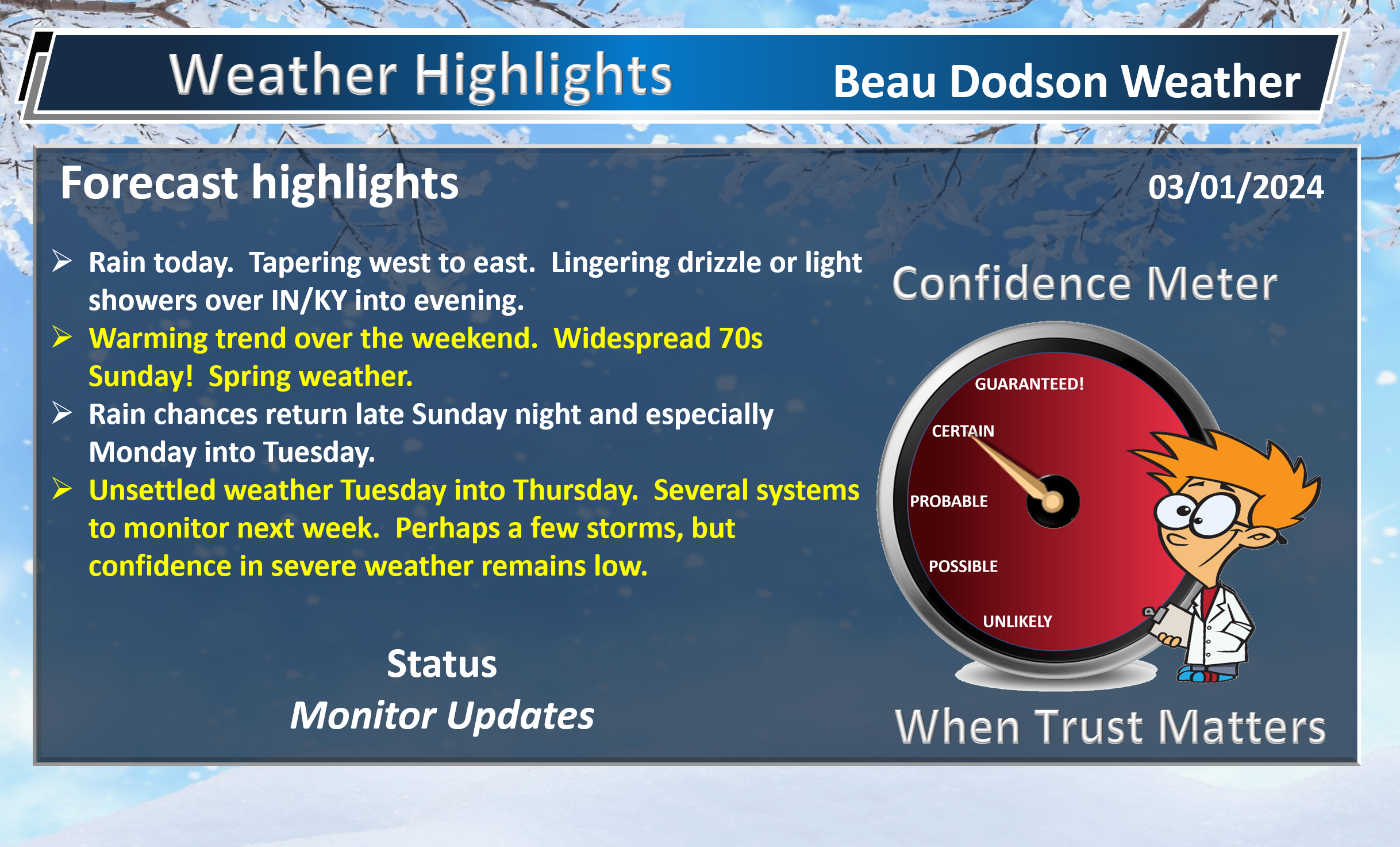
1. Is lightning in the forecast? YES. Lightning is possible Monday, Tuesday, and Wednesday of next week.
2. Are severe thunderstorms in the forecast? MONITOR. At this time, there are no severe weather threats. I will need to monitor next week as we will have several systems moving through the region. If the atmosphere is a bit more unstable, then a low end severe risk could materialize. Monitor updates.
3. Is flash flooding in the forecast? NOT AT THIS TIME. I will monitor next week. Several rain events will be possible.
4. Will non-thunderstorm winds top 40 mph? NOT AT THIS TIME.
5. Will the heat index exceed 100 degrees? NO.
6. Will the wind chill dip below 10 degrees? NO.
7. Is measurable snow and/or sleet in the forecast? NO.
8. Is freezing rain/ice in the forecast? NO.
Freezing rain is rain that falls and instantly freezes on objects such as trees and power lines Freezing fog possible, as well.
.

Fire weather risk level.
Friday and Friday night: 3. Very low risk.
Saturday and Saturday night: 4. Low risk.
Sunday: 5. Medium risk.
Fire Weather Discussion
Some light precipitation is expected late tonight and Friday. Otherwise, it will be rather humid with light winds and poor dispersion. South winds will increase through the weekend, and as temperatures climb back into the 70s Sunday, humidity levels may drop down near 40%. It will be quite mild and humid next week, with multiple chances of wetting rains.
A Haines Index of 6 means a high potential for an existing fire to become large or exhibit erratic fire behavior, 5 means medium potential, 4 means low potential, and anything less than 4 means very low potential.
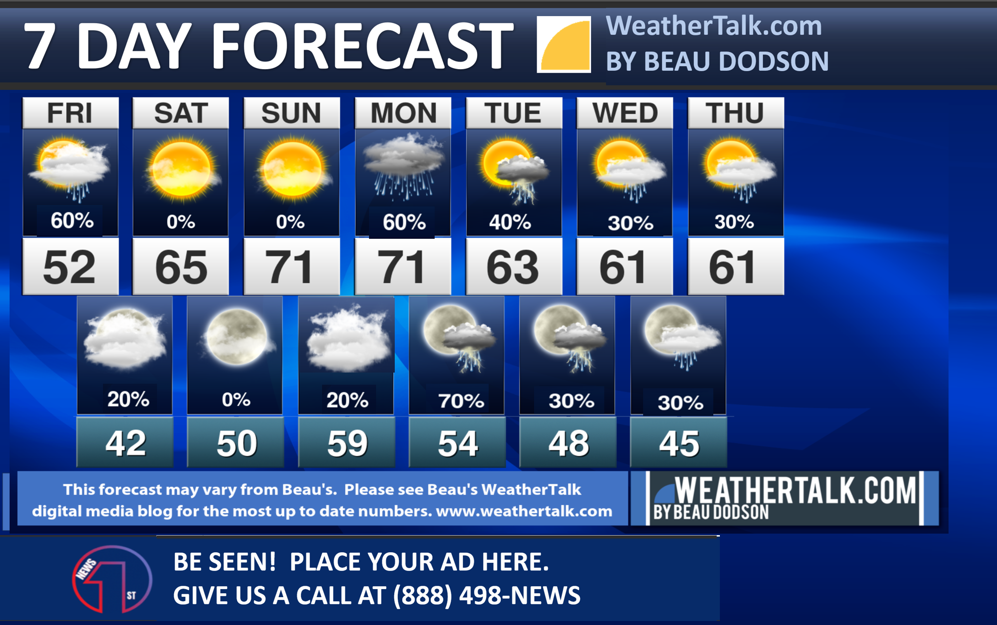
Seven-day forecast for southeast Missouri, southern Illinois, western Kentucky, and western Tennessee.
This is a BLEND for the region. Scroll down to see the region by region forecast.
.

THE FORECAST IS GOING TO VARY FROM LOCATION TO LOCATION. Scroll down to see your local forecast details.
48-hour forecast Graphics


.
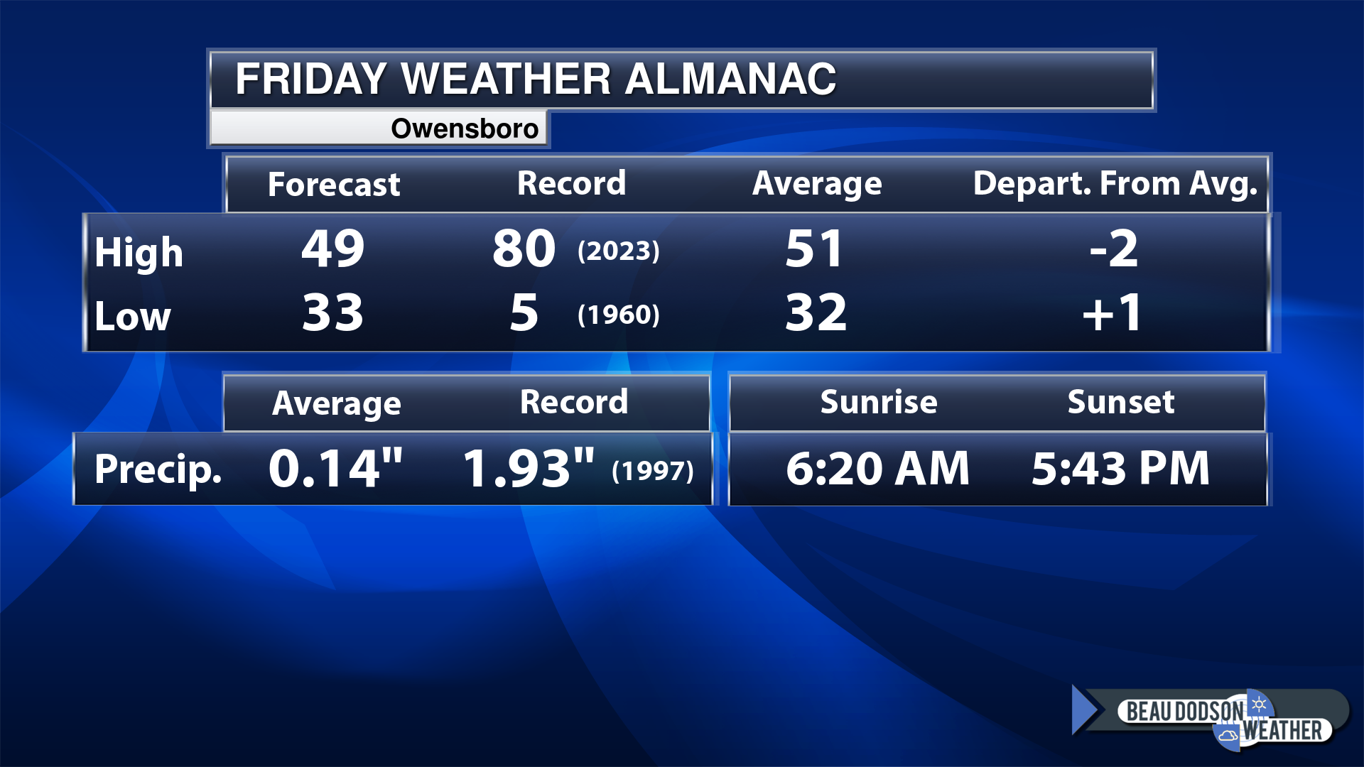
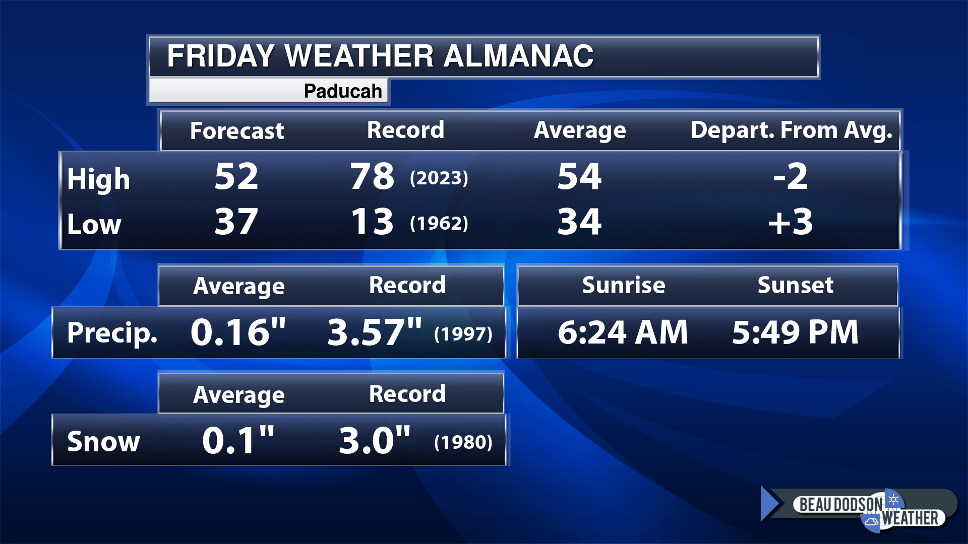
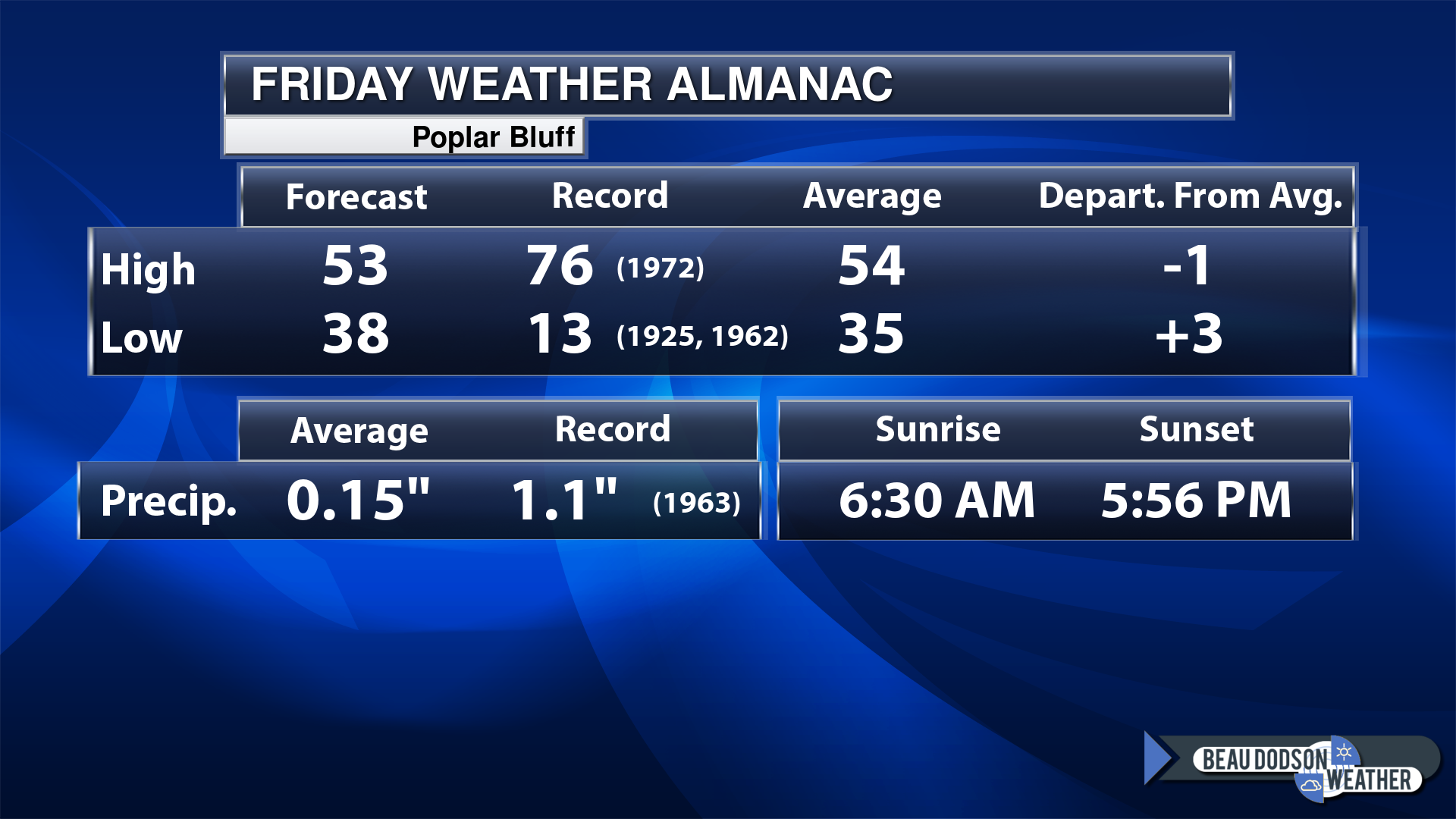
Today’s Local Almanacs (for a few select cities). Your location will be comparable.
Note, the low is this morning’s low and not tomorrows.
The forecast temperature shows you today’s expected high and this morning’s low.
The graphic shows you the record high and record low for today. It shows you what year that occurred, as well.
It then shows you what today’s average temperature is.
It shows you the departures (how may degrees above or below average temperatures will be ).
It shows you the average precipitation for today. Average comes from thirty years of rain totals.
It also shows you the record rainfall for the date and what year that occurred.
The sunrise and sunset are also shown.

![]()
.
.
Friday Forecast: Cloudy. Rain this morning. Rain tapering off west to east as the day wears on. Lingering showers and drizzle into the afternoon over southeast IL and western KY. Cool temperatures with clouds and rain. Rain may be mixed with snow and sleet over portions of SE MO and south IL.
What is the chance of precipitation?
Far northern southeast Missouri ~ 90%
Southeast Missouri ~ 60%
The Missouri Bootheel ~ 40%
I-64 Corridor of southern Illinois ~ 90%
Southern Illinois ~ 60%
Extreme southern Illinois (southern seven counties) ~ 100%
Far western Kentucky (Purchase area) ~ 100%
The Pennyrile area of western KY ~ 100%
Northwest Kentucky (near Indiana border) ~ 70%
Northwest Tennessee ~ 60%
Coverage of precipitation: Numerous early and then tapering west to east
Timing of the precipitation: Any given point of time. More likely before 1 PM vs after 1 PM.
Far northern southeast Missouri ~ 48° to 52°
Southeast Missouri ~ 48° to 52°
The Missouri Bootheel ~ 50° to 52°
I-64 Corridor of southern Illinois ~ 48° to 52°
Southern Illinois ~ 50° to 52°
Extreme southern Illinois (southern seven counties) ~ 50° to 52°
Far western Kentucky ~ 50° to 52°
The Pennyrile area of western KY ~ 50° to 52°
Northwest Kentucky (near Indiana border) ~ 50° to 52°
Northwest Tennessee ~ 50° to 52°
Winds will be from this direction: South 7 to 14 mph
Wind chill or heat index (feels like) temperature forecast: 44° to 48°
What impacts are anticipated from the weather? Wet roadways.
Should I cancel my outdoor plans? Have a plan B the first half of the day. Rain is likely.
UV Index: 2. Low.
Sunrise: 6:25AM
Sunset: 5:50 PM .
.
Friday Night Forecast: Decreasing clouds. Any remaining showers will end. Patchy fog and drizzle possible.
What is the chance of precipitation?
Far northern southeast Missouri ~ 0%
Southeast Missouri ~ 0%
The Missouri Bootheel ~ 0%
I-64 Corridor of southern Illinois ~ 0%
Southern Illinois ~ 20%
Extreme southern Illinois (southern seven counties) ~ 20%
Far western Kentucky (Purchase area) ~ 30%
The Pennyrile area of western KY ~ 30%
Northwest Kentucky (near Indiana border) ~ 30%
Northwest Tennessee ~ 20%
Coverage of precipitation: Widely scattered (mainly E NE)
Timing of the precipitation: Ending before 9 PM
Temperature range:
Far northern southeast Missouri ~ 34° to 38°
Southeast Missouri ~ 38° to 42°
The Missouri Bootheel ~ 40° to 44°
I-64 Corridor of southern Illinois ~ 36° to 38°
Southern Illinois ~ 40° to 42°
Extreme southern Illinois (southern seven counties) ~ 42° to 44°
Far western Kentucky ~ 42° to 45°
The Pennyrile area of western KY ~ 42° to 45°
Northwest Kentucky (near Indiana border) ~ 42° to 45°
Northwest Tennessee ~ 43° to 46°
Winds will be from this direction: South southwest at 7 to 14 mph.
Wind chill or heat index (feels like) temperature forecast: 30° to 42°
What impacts are anticipated from the weather? Wet roadways and lower visibility in fog.
Should I cancel my outdoor plans?
Moonrise: 11:58PM
Moonset: 9:10 AM
The phase of the moon: Waning Gibbous
.
Saturday Forecast: Some morning clouds. Becoming mostly sunny. Nice. Warmer.
What is the chance of precipitation?
Far northern southeast Missouri ~ 0%
Southeast Missouri ~ 0%
The Missouri Bootheel ~ 0%
I-64 Corridor of southern Illinois ~ 0%
Southern Illinois ~ 0%
Extreme southern Illinois (southern seven counties) ~ 0%
Far western Kentucky (Purchase area) ~ 0%
The Pennyrile area of western KY ~ 0%
Northwest Kentucky (near Indiana border) ~ 0%
Northwest Tennessee ~ 0%
Coverage of precipitation:
Timing of the precipitation:
Far northern southeast Missouri ~ 63° to 66°
Southeast Missouri ~ 63° to 66°
The Missouri Bootheel ~ 63° to 66°
I-64 Corridor of southern Illinois ~ 63° to 66°
Southern Illinois ~ 63° to 66°
Extreme southern Illinois (southern seven counties) ~ 63° to 66°
Far western Kentucky ~ 63° to 66°
The Pennyrile area of western KY ~ 63° to 66°
Northwest Kentucky (near Indiana border) ~ 63° to 66°
Northwest Tennessee ~ 63° to 66°
Winds will be from this direction: South 8 to 16 mph.
Wind chill or heat index (feels like) temperature forecast: 60° to 65°
What impacts are anticipated from the weather?
Should I cancel my outdoor plans?
UV Index: 5. Moderate.
Sunrise: 6:24 AM
Sunset: 5:51 PM .
.
Saturday Night Forecast: Partly cloudy. Not as cold.
What is the chance of precipitation?
Far northern southeast Missouri ~ 0%
Southeast Missouri ~ 0%
The Missouri Bootheel ~ 0%
I-64 Corridor of southern Illinois ~ 0%
Southern Illinois ~ 0%
Extreme southern Illinois (southern seven counties) ~ 0%
Far western Kentucky (Purchase area) ~ 0%
The Pennyrile area of western KY ~ 0%
Northwest Kentucky (near Indiana border) ~ 0%
Northwest Tennessee ~ 0%
Coverage of precipitation:
Timing of the precipitation:
Temperature range:
Far northern southeast Missouri ~ 46° to 50°
Southeast Missouri ~ 46° to 50°
The Missouri Bootheel ~ 46° to 50°
I-64 Corridor of southern Illinois ~ 46° to 50°
Southern Illinois ~ 46° to 50°
Extreme southern Illinois (southern seven counties) ~ 46° to 50°
Far western Kentucky ~ 46° to 50°
The Pennyrile area of western KY ~ 46° to 50°
Northwest Kentucky (near Indiana border) ~ 46° to 50°
Northwest Tennessee ~ 46° to 50°
Winds will be from this direction: South 10 to 25 mph. Gusty.
Wind chill or heat index (feels like) temperature forecast: 42° to 50°
What impacts are anticipated from the weather?
Should I cancel my outdoor plans?
Moonrise:
Moonset: 9:43 AM
The phase of the moon: Waning Gibbous
.
Sunday Forecast: Partly to mostly sunny. Very mild for early March. Windy.
What is the chance of precipitation?
Far northern southeast Missouri ~ 0%
Southeast Missouri ~ 0%
The Missouri Bootheel ~ 0%
I-64 Corridor of southern Illinois ~ 0%
Southern Illinois ~ 0%
Extreme southern Illinois (southern seven counties) ~ 0%
Far western Kentucky (Purchase area) ~ 0%
The Pennyrile area of western KY ~ 0%
Northwest Kentucky (near Indiana border) ~ 0%
Northwest Tennessee ~ 0%
Coverage of precipitation:
Timing of the precipitation:
Far northern southeast Missouri ~ 73° to 76°
Southeast Missouri ~ 74° to 78°
The Missouri Bootheel ~ 74° to 78°
I-64 Corridor of southern Illinois ~ 73° to 76°
Southern Illinois ~ 73° to 76°
Extreme southern Illinois (southern seven counties) ~ 73° to 76°
Far western Kentucky ~ 73° to 76°
The Pennyrile area of western KY ~ 73° to 76°
Northwest Kentucky (near Indiana border) ~ 73° to 76°
Northwest Tennessee ~ 74° to 78°
Winds will be from this direction: South 15 to 30 mph.
Wind chill or heat index (feels like) temperature forecast: 73° to 76°
What impacts are anticipated from the weather?
Should I cancel my outdoor plans?
UV Index: 5. Moderate.
Sunrise: 6:23 AM
Sunset: 5:52 PM .
.
Sunday Night Forecast: Becoming cloudy. Mild for early March. A slight chance of a few showers moving in from Arkansas and Tennessee. Moving north northeast.
What is the chance of precipitation?
Far northern southeast Missouri ~ 10%
Southeast Missouri ~ 10%
The Missouri Bootheel ~ 20%
I-64 Corridor of southern Illinois ~ 10%
Southern Illinois ~ 10%
Extreme southern Illinois (southern seven counties) ~ 20%
Far western Kentucky (Purchase area) ~ 20%
The Pennyrile area of western KY ~ 20%
Northwest Kentucky (near Indiana border) ~ 20%
Northwest Tennessee ~ 20%
Coverage of precipitation: Widely scattered
Timing of the precipitation: After 3 AM.
Temperature range:
Far northern southeast Missouri ~ 54° to 58°
Southeast Missouri ~ 54° to 58°
The Missouri Bootheel ~ 54° to 58°
I-64 Corridor of southern Illinois ~ 54° to 58°
Southern Illinois ~ 54° to 58°
Extreme southern Illinois (southern seven counties) ~ 54° to 58°
Far western Kentucky ~ 54° to 58°
The Pennyrile area of western KY ~ 54° to 58°
Northwest Kentucky (near Indiana border) ~ 54° to 58°
Northwest Tennessee ~ 54° to 58°
Winds will be from this direction: South 10 to 25 mph. Gusty.
Wind chill or heat index (feels like) temperature forecast: 52° to 54°
What impacts are anticipated from the weather?
Should I cancel my outdoor plans?
Moonrise: 1:03 AM
Moonset: 10:24 AM
The phase of the moon: Last Quarter
.
Click here if you would like to return to the top of the page.

-
- Rain tapers off later today. Patchy drizzle this evening and fog.
- Warm Saturday and Sunday. Sunday will feature widespread 70s! Spring is in the air.
- Multiple rain chances Sunday night into the middle of next week.
- Some thunderstorms are possible, but for now the severe risk appears low (for Monday into Thursday). But, monitor updates in case something changes. Esp in the long range.
Weather advice:
Do you have any suggestions or comments? Email me at beaudodson@usawx.com
Make sure you have three to five ways of receiving your severe weather information.
.
Beau’s Forecast Discussion
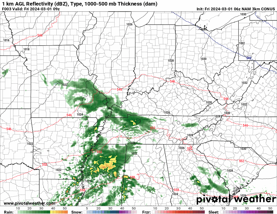
Good wet morning!
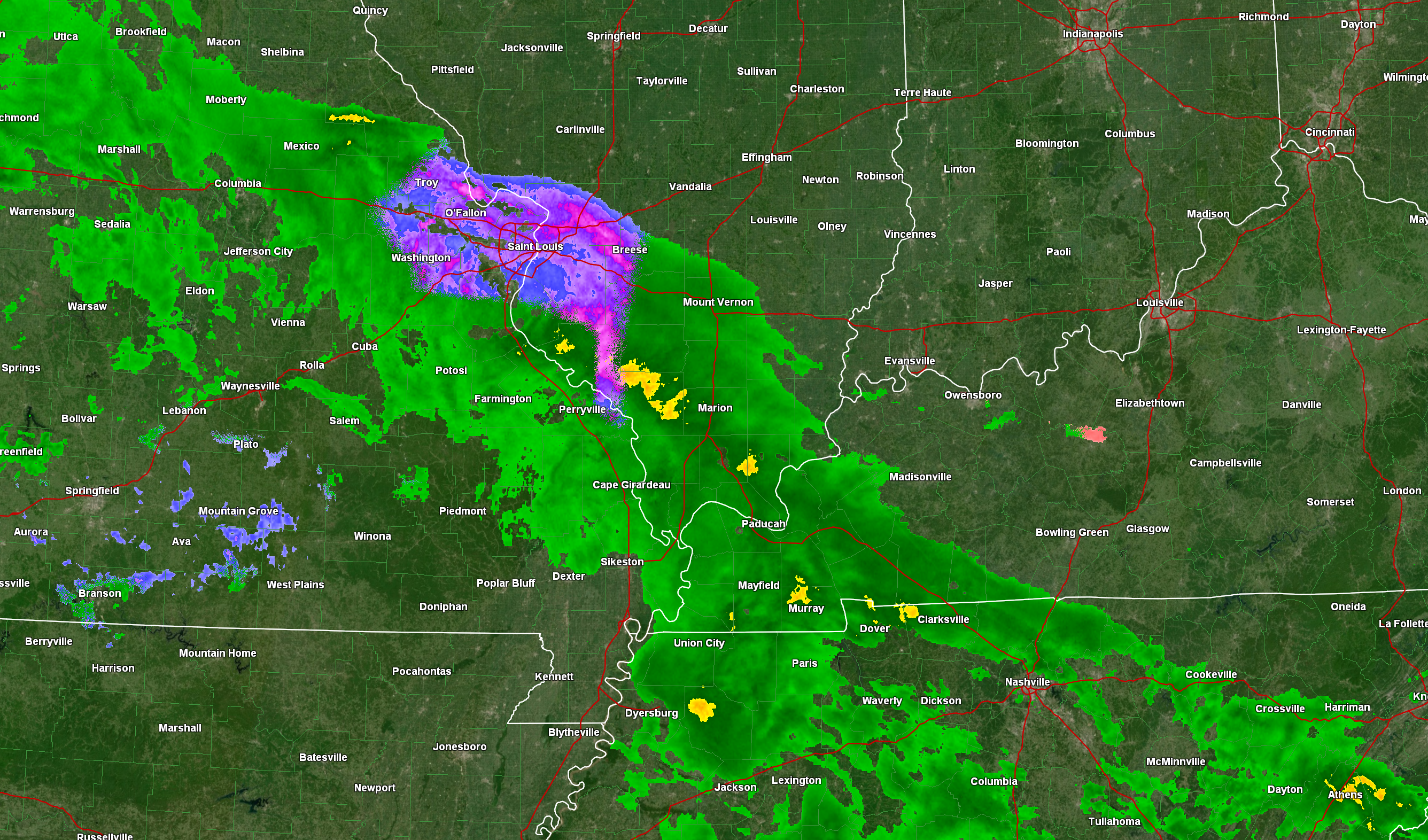
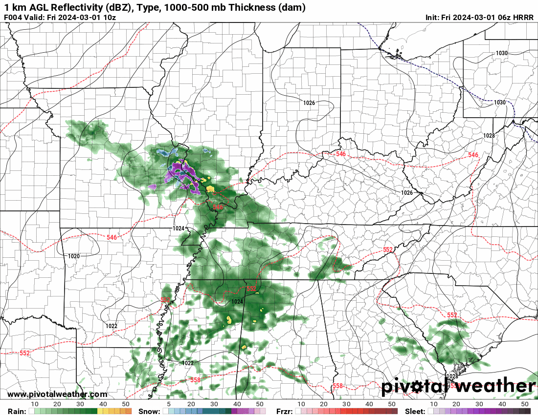
Radar at 4 am was covered in rain. The rain was moving northeast. As you can see the rain has already ended over portions of southeast Missouri.
The rain will taper southwest to northeast as we move through the morning hours. Rain will linger into the evening over southeast Illinois and western Kentucky. Especially our eastern counties.
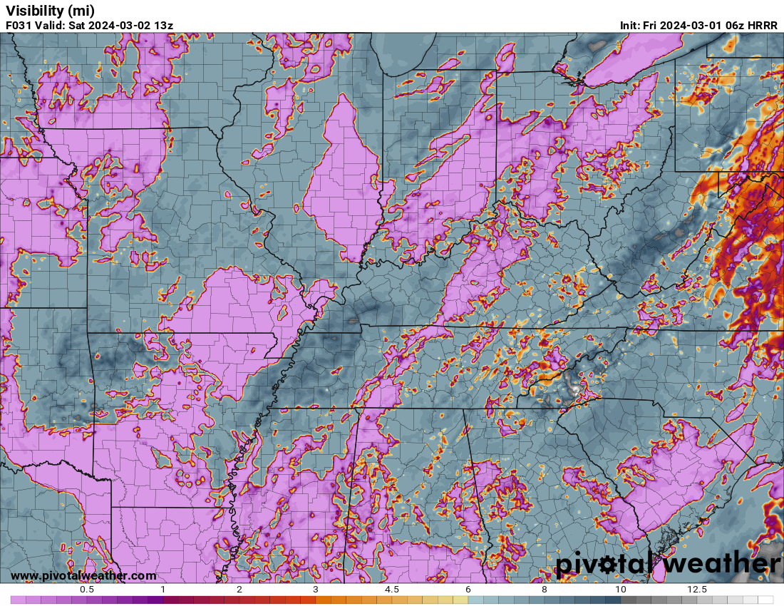
Patchy fog tonight, as well. Rain totals will be light (see graphic below).
Clouds will linger today, as well.
Patchy fog tonight with low visibility.
You can see that fog on this visibility graphic.
Saturday and Sunday is when spring returns. As a matter of fact, you can expect widespread 70s by Sunday. It is going to feel nice.
Gusty winds will develop Saturday and Sunday. Gusts by Sunday could approach 30 mph. Perhaps a bit higher if we have quite a bit of sunshine.
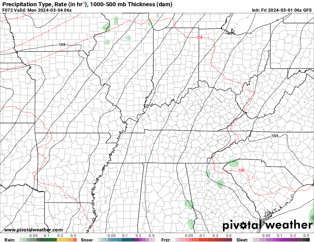
Several systems will bring increasing rain chances Monday into Wednesday of next week. Perhaps beyond. It looks to be unsettled.
Rain totals with the Monday system will be a bit heavier. Some towns could exceed an inch of rain Monday into Tuesday.
There are some questions about the % potential of rain Tuesday night into Friday of next week. A fast moving jet stream flow could mean several more low pressure centers will bring clouds and rain. Thunderstorms, as well.
Although the GFS and EC models are quite busy, there are questions about the track of the systems and intensity. The biggest question centers around severe thunderstorms.
The atmosphere will be somewhat unstable Monday, but not extreme. I could see an argument to be made for a marginal level one severe weather risk. Let’s keep an eye on it. The concern would be a few reports of damaging wind.
I will monitor beyond Monday. Stay tuned and check back often. It is that time of the year (although any time of the year seems an issue these days).
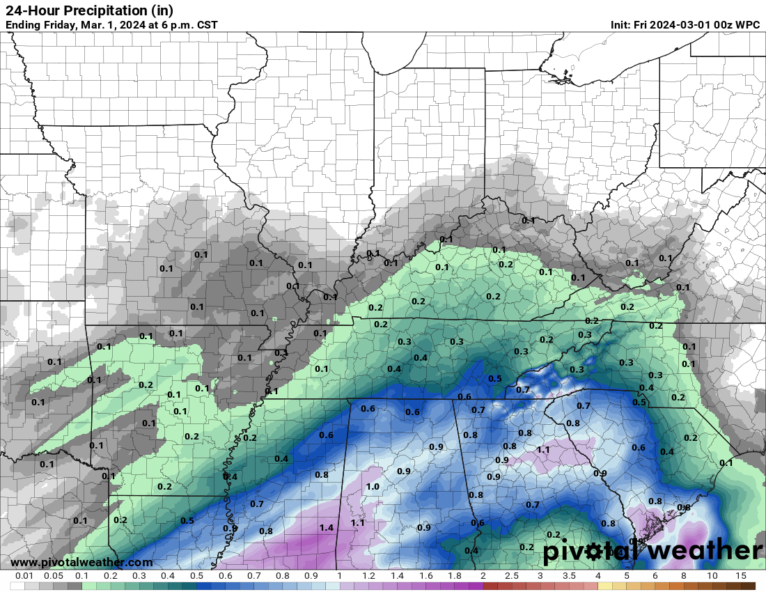
Rainfall totals today will be light. Not much.
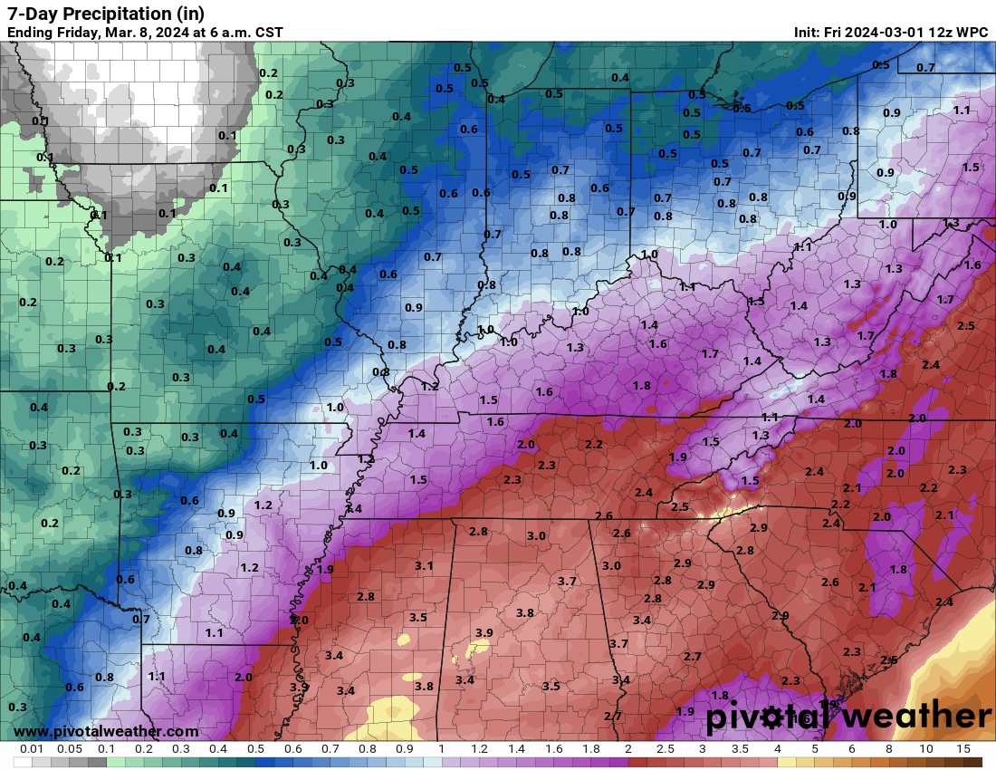
Rainfall through day seven. As you can see, some moderate rain is possible as we move into next week. Perhaps locally heavy. We will need to watch the potential of thunderstorms mixed in with the rain. That would enhance rain totals.
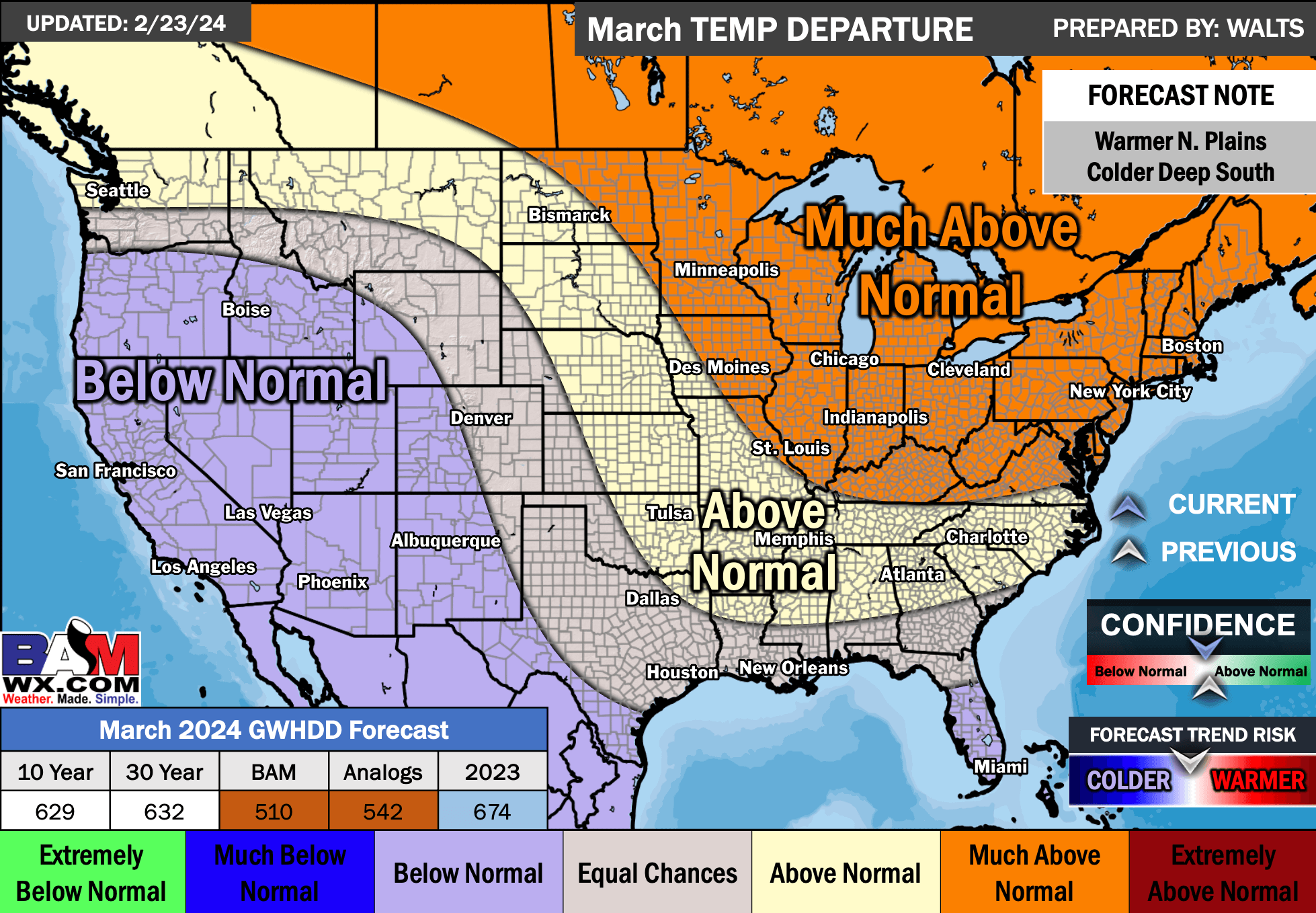
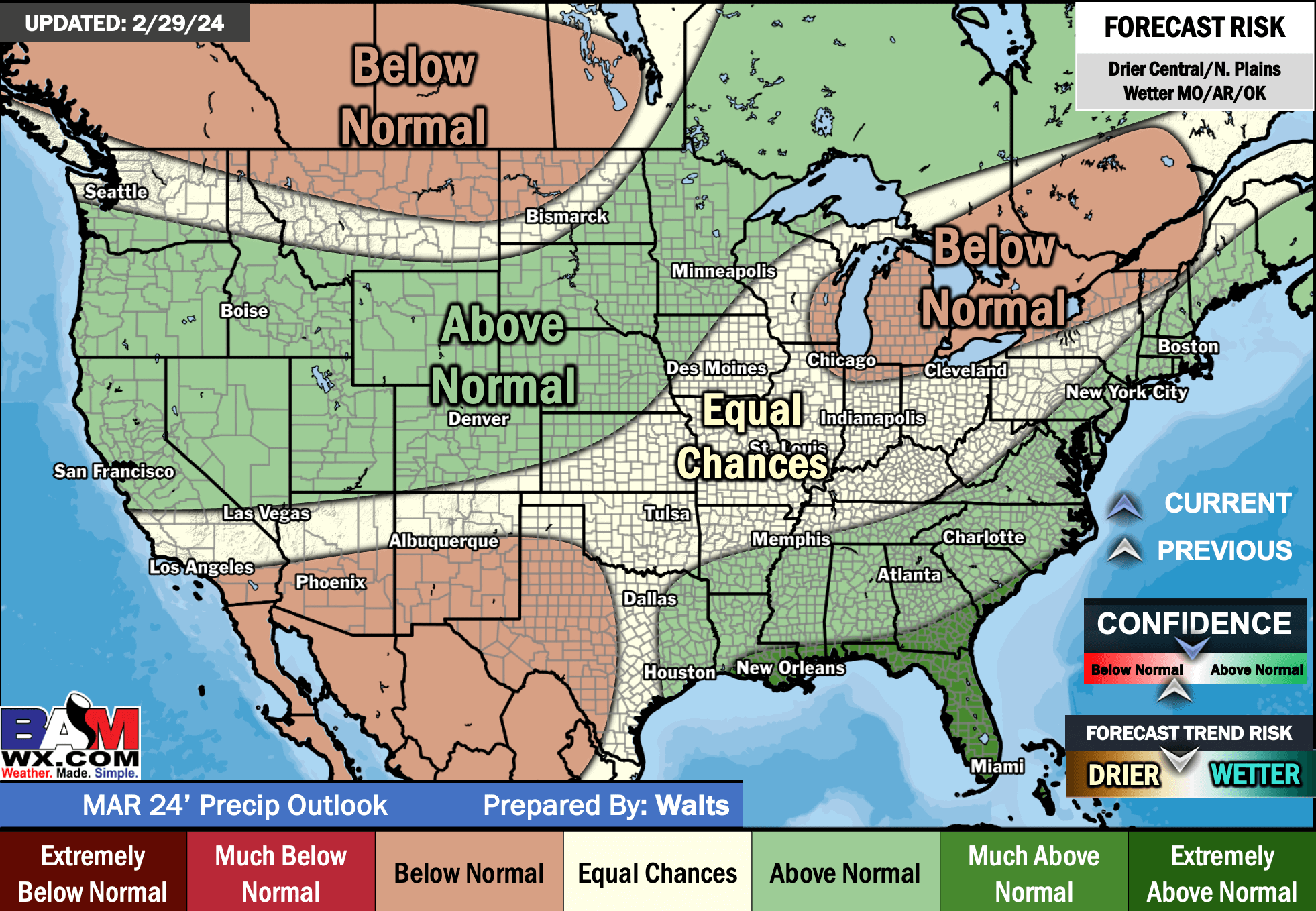
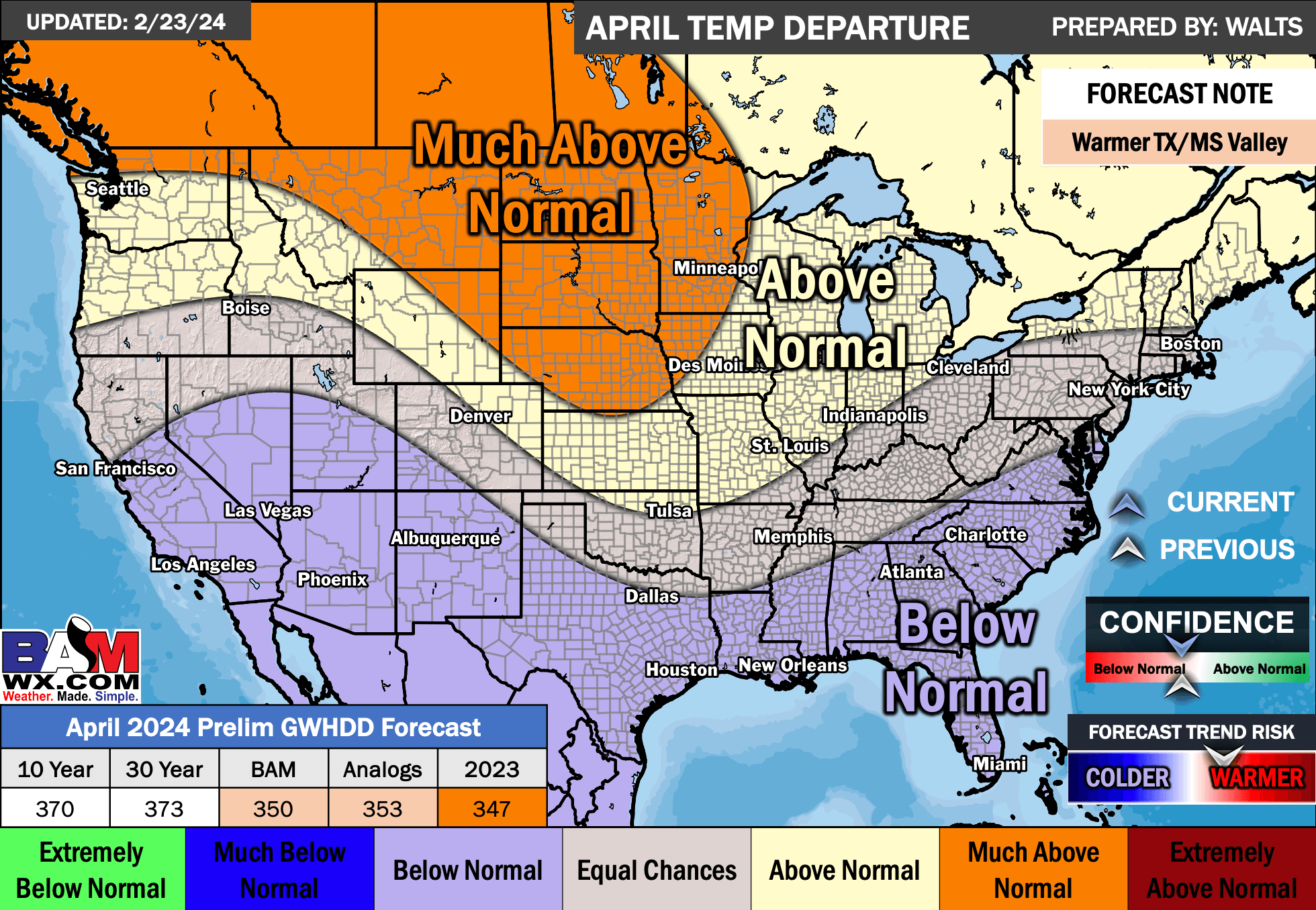
Updated Seasonal Outlooks have been posted by the long range team
March Temperature Outlook
March Precipitation Outlook
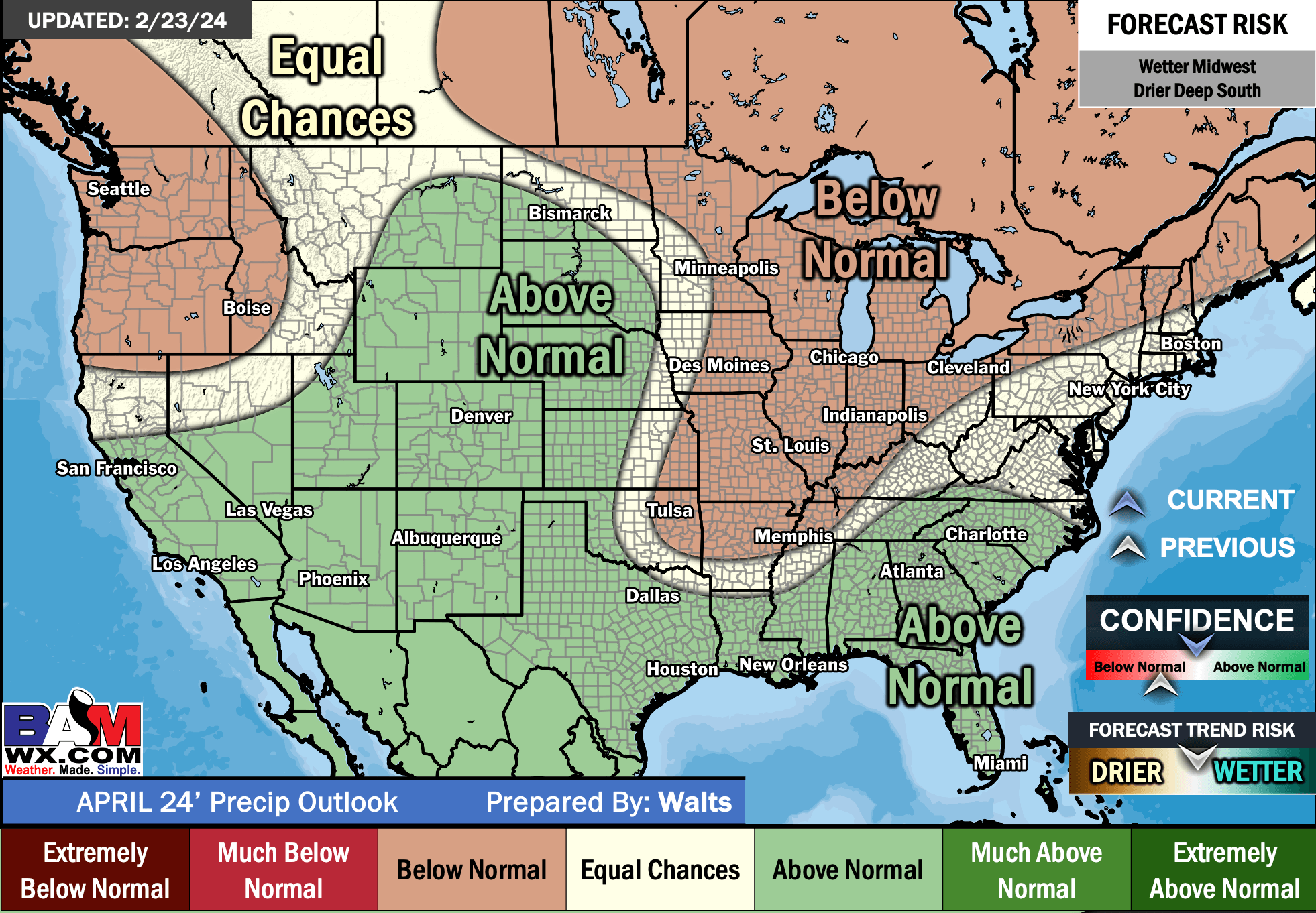
April Temperature Outlook
April Precipitation Outlook
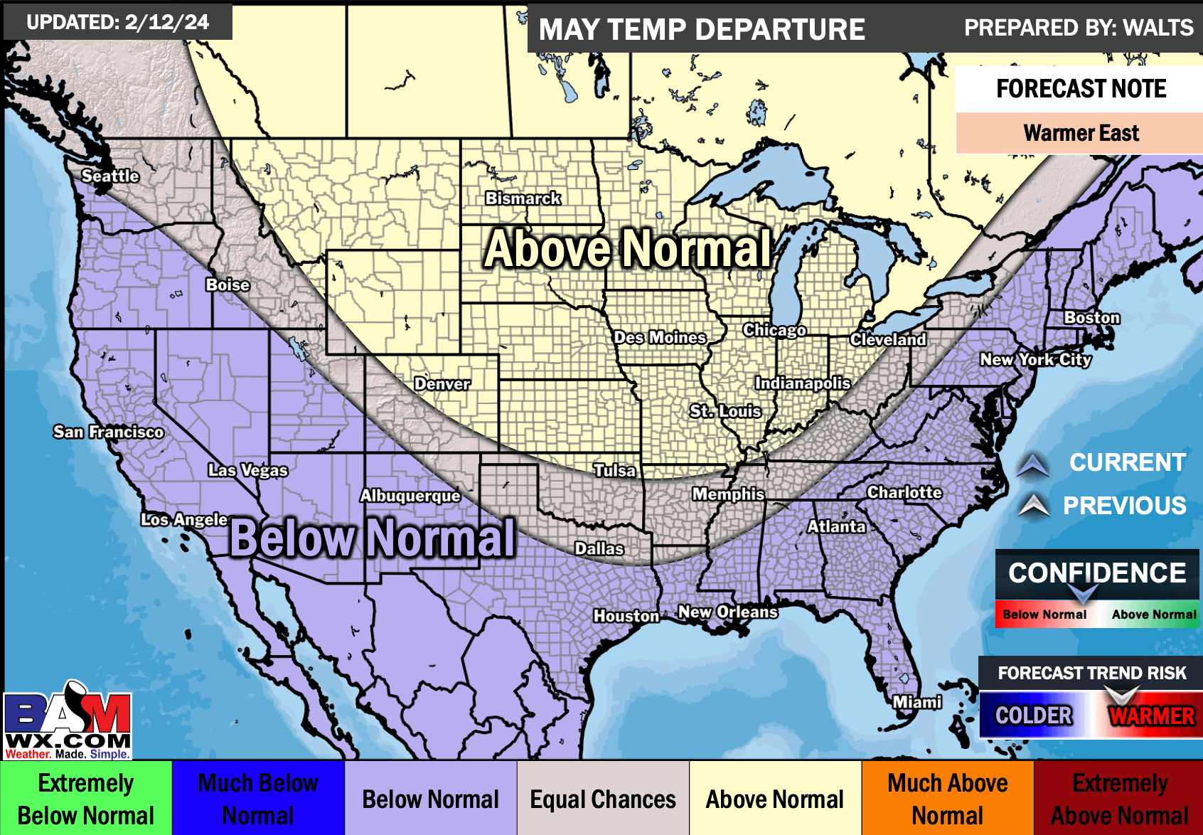
May Temperature Outlook
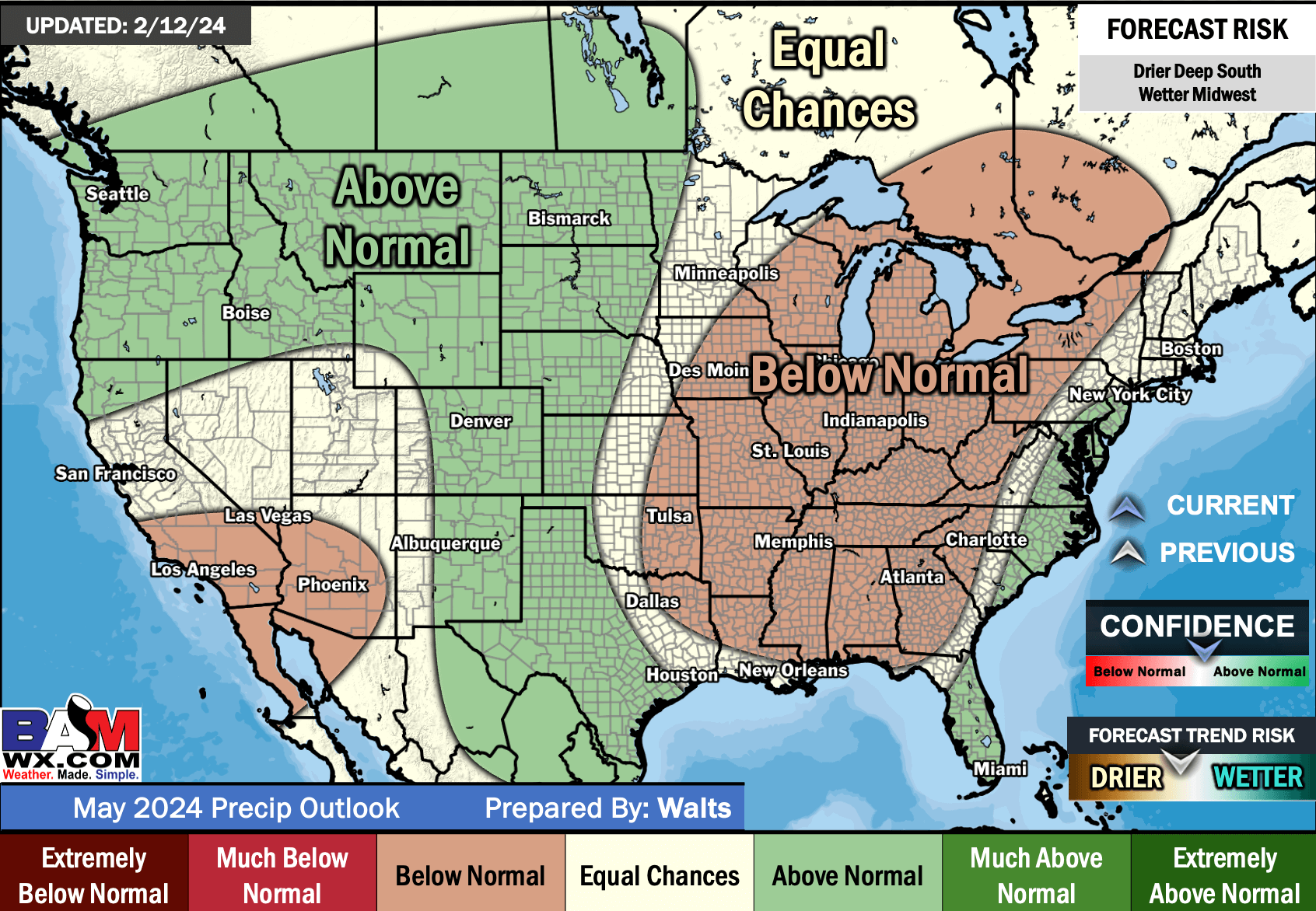
May Precipitation Outlook
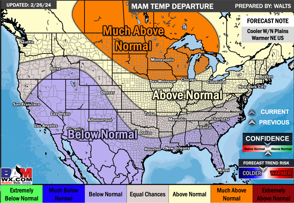
March, April, and May Temperature Outlook
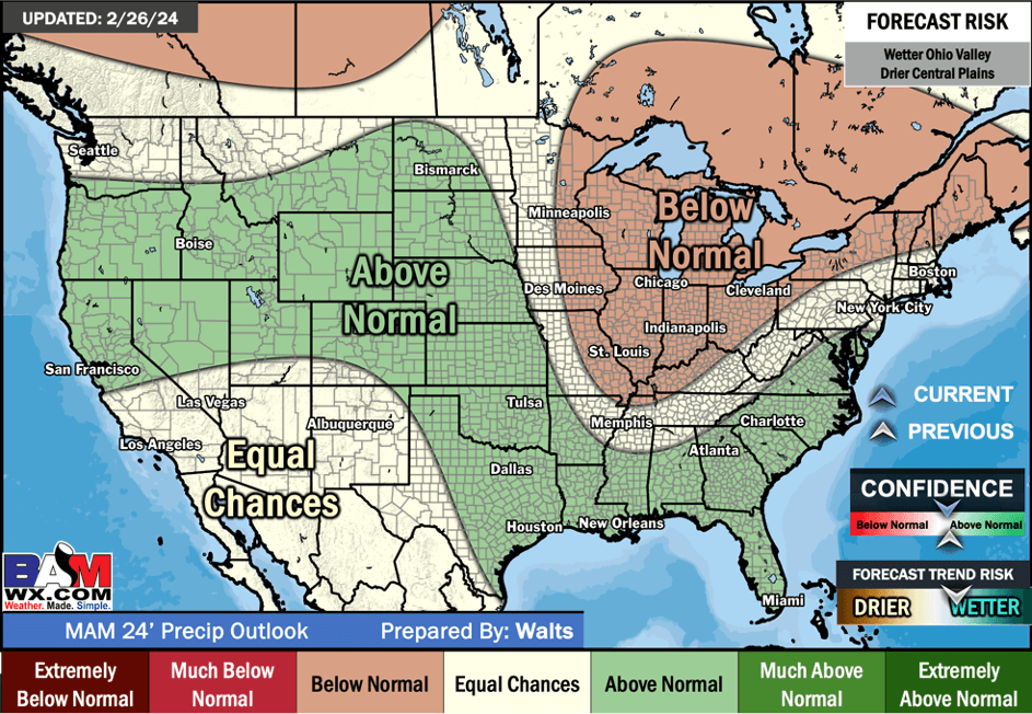
March, April, and May Precipitation Outlook
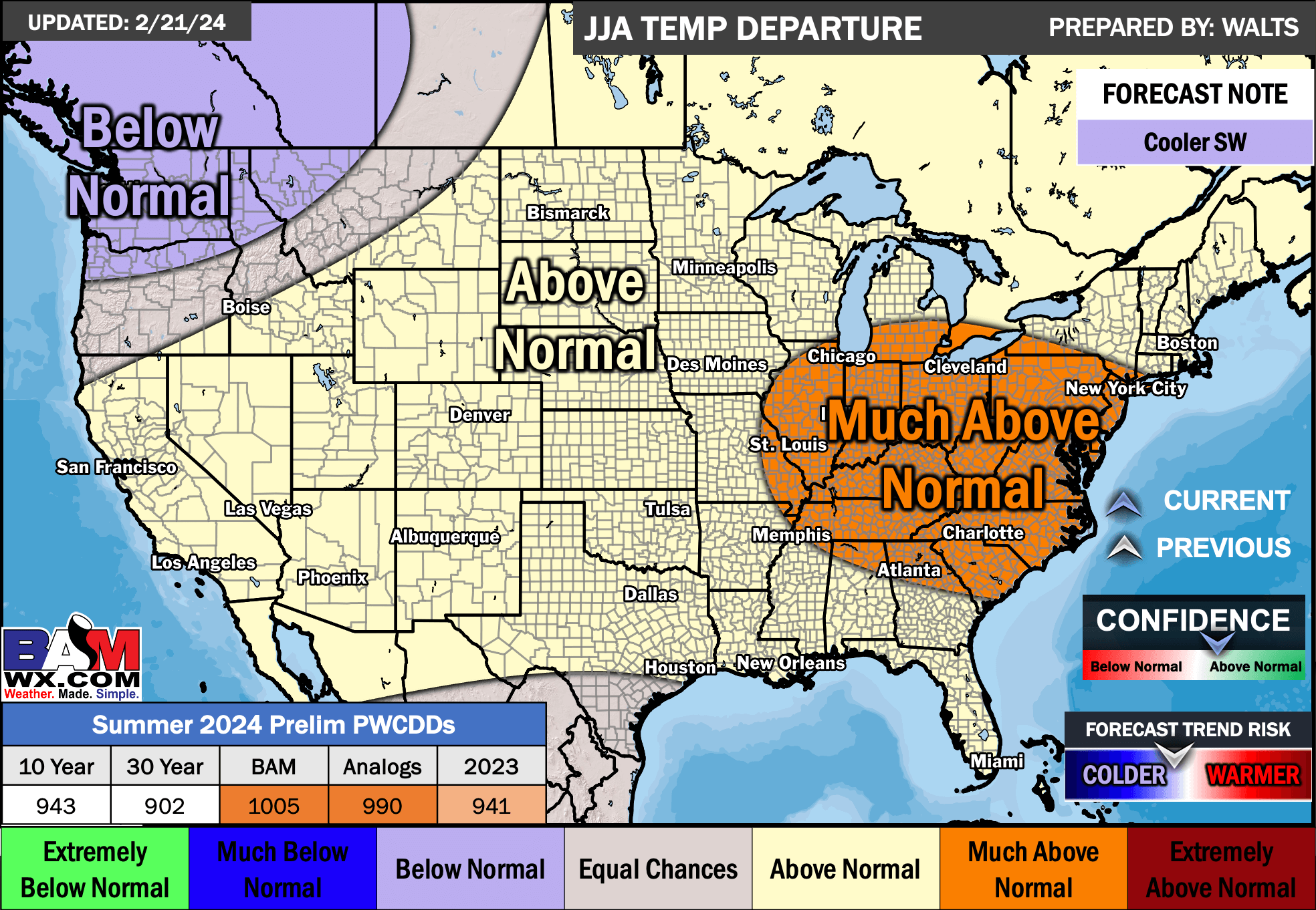
June, July, and August Temperature Outlook
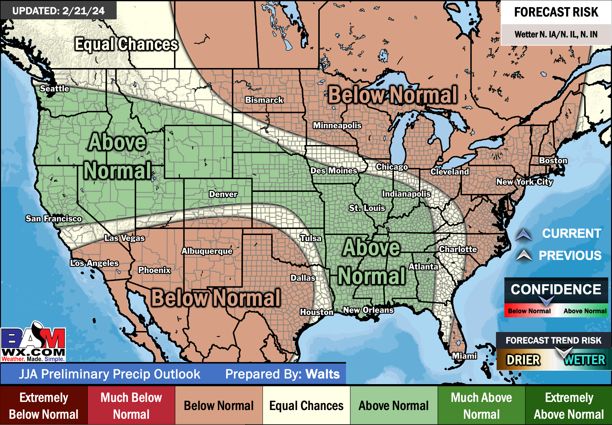
June, July, and August Precipitation Outlook
![]()
.
Click here if you would like to return to the top of the page.
This outlook covers southeast Missouri, southern Illinois, western Kentucky, and far northwest Tennessee.

.
Today’s Storm Prediction Center’s Severe Weather Outlook
Light green is where thunderstorms may occur but should be below severe levels.
Dark green is a level one risk. Yellow is a level two risk. Orange is a level three (enhanced) risk. Red is a level four (moderate) risk. Pink is a level five (high) risk.
One is the lowest risk. Five is the highest risk.
A severe storm is one that produces 58 mph wind or higher, quarter size hail, and/or a tornado.
Explanation of tables. Click here.

.
Tornado Probability Outlook

.
Large Hail Probability Outlook

.
High wind Probability Outlook

.
Tomorrow’s severe weather outlook.

.
Day Three Severe Weather Outlook

.

.
The images below are from NOAA’s Weather Prediction Center.
24-hour precipitation outlook..
 .
.
.
48-hour precipitation outlook.
. .
.
![]()
_______________________________________
.

Click here if you would like to return to the top of the page.
Again, as a reminder, these are models. They are never 100% accurate. Take the general idea from them.
What should I take from these?
- The general idea and not specifics. Models usually do well with the generalities.
- The time-stamp is located in the upper left corner.
.
What am I looking at?
You are looking at computer model data. Meteorologists use many different models to forecast the weather.
Occasionally, these maps are in Zulu time. 12z=7 AM. 18z=1 PM. 00z=7 PM. 06z=1 AM
Green represents light rain. Dark green represents moderate rain. Yellow and orange represent heavier rain.
.
This animation is the HRRR Model.
Occasionally, these maps are in Zulu time. 12z=6 AM. 18z=12 PM. 00z=6 PM. 06z=12 AM
Double click images to enlarge them. Blue is snow. Pink is a wintry mix. Green is rain.
.
This animation is the NAM 3Z Model.
Occasionally, these maps are in Zulu time. 12z=6 AM. 18z=12 PM. 00z=6 PM. 06z=12 AM
Double click images to enlarge them.
.
This animation is the GFS Model.
Green is rain. Yellow and orange are heavier rain. Pink is a wintry mix. Blue is snow. Dark blue is heavier snow.
Occasionally, these maps are in Zulu time. 12z=6 AM. 18z=12 PM. 00z=6 PM. 06z=12 AM
Double click images to enlarge them.
.
This animation is the EC Model.
Green is rain. Yellow and orange are heavier rain. Pink is a wintry mix. Blue is snow. Dark blue is heavier snow.
Occasionally, these maps are in Zulu time. 12z=6 AM. 18z=12 PM. 00z=6 PM. 06z=12 AM
Double click images to enlarge them.
..![]()

.
Click here if you would like to return to the top of the page.
.Average high temperatures for this time of the year are around 51 degrees.
Average low temperatures for this time of the year are around 31 degrees.
Average precipitation during this time period ranges from 0.50″ to 1.00″
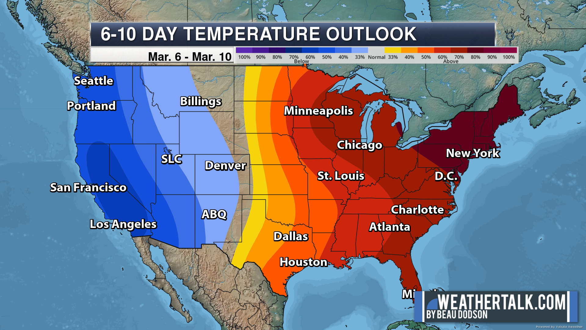
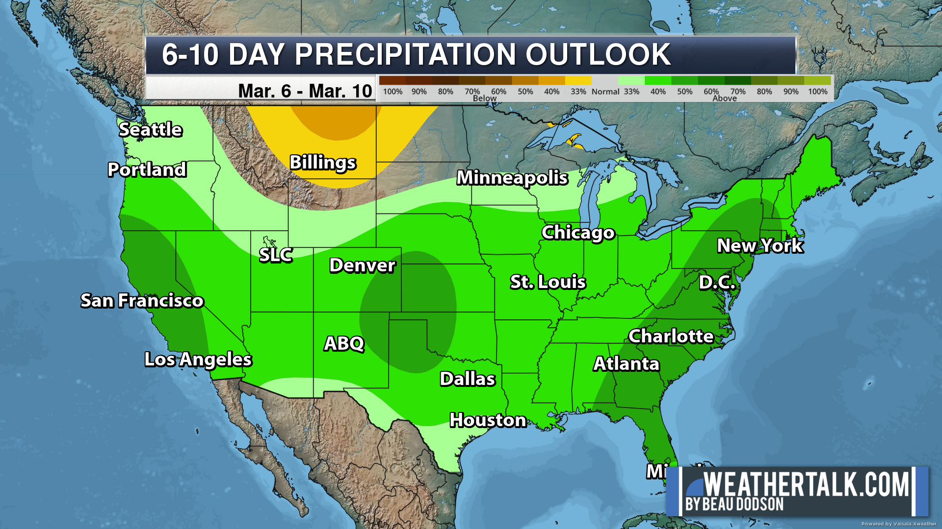
Six to Ten Day Outlook.
Blue is below average. Red is above average. The no color zone represents equal chances.
Average highs for this time of the year are in the lower 60s. Average lows for this time of the year are in the lower 40s.
Green is above average precipitation. Yellow and brown favors below average precipitation. Average precipitation for this time of the year is around one inch per week.
.

Average low temperatures for this time of the year are around 32 degrees.
Average precipitation during this time period ranges from 0.50″ to 1.00″
.
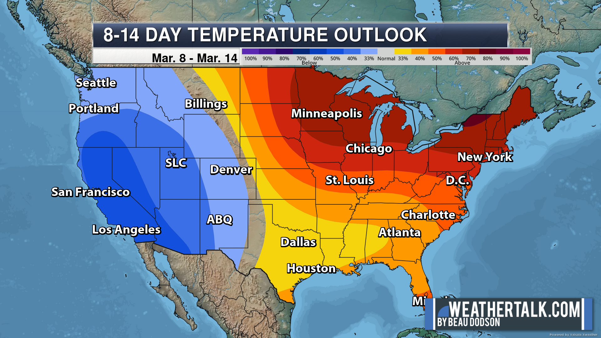
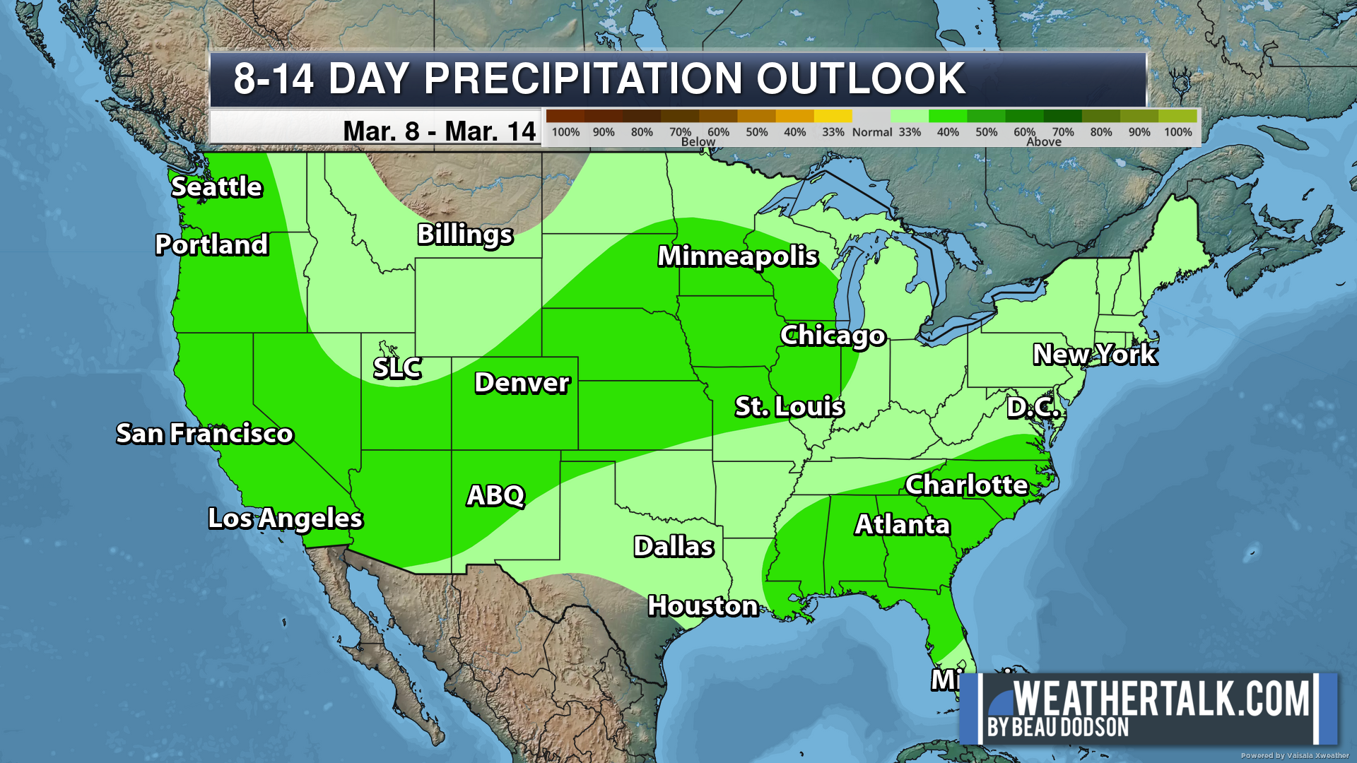
Eight to Fourteen Day Outlook.
Blue is below average. Red is above average. The no color zone represents equal chances.
Green is above average precipitation. Yellow and brown favors below average precipitation. Average precipitation for this time of the year is around one inch per week.
.
![]()
The app is for subscribers. Subscribe at www.weathertalk.com/welcome then go to your app store and search for WeatherTalk
Subscribers, PLEASE USE THE APP. ATT and Verizon are not reliable during severe weather. They are delaying text messages.
The app is under WeatherTalk in the app store.

Apple users click here

Android users click here
.

Radars and Lightning Data
Interactive-city-view radars. Clickable watches and warnings.
https://wtalk.co/B3XHASFZ
If the radar is not updating then try another one. If a radar does not appear to be refreshing then hit Ctrl F5. You may also try restarting your browser.
Backup radar site in case the above one is not working.
https://weathertalk.com/morani
Regional Radar
https://imagery.weathertalk.com/prx/RadarLoop.mp4
** NEW ** Zoom radar with chaser tracking abilities!
ZoomRadar
Lightning Data (zoom in and out of your local area)
https://wtalk.co/WJ3SN5UZ
Not working? Email me at beaudodson@usawx.com
National map of weather watches and warnings. Click here.
Storm Prediction Center. Click here.
Weather Prediction Center. Click here.
.

Live lightning data: Click here.
Real time lightning data (another one) https://map.blitzortung.org/#5.02/37.95/-86.99
Our new Zoom radar with storm chases
.
.

Interactive GOES R satellite. Track clouds. Click here.
GOES 16 slider tool. Click here.
College of DuPage satellites. Click here
.

Here are the latest local river stage forecast numbers Click Here.
Here are the latest lake stage forecast numbers for Kentucky Lake and Lake Barkley Click Here.
.
.
Find Beau on Facebook! Click the banner.


 .
.