Click on the words below to subscribe
Storm Tracking Links
Interactive local city-view radars. Clickable watches and warnings.
https://wtalk.co/B3XHASFZ
Backup radar site in case the above one is not working.
https://weathertalk.com/morani
Regional Radar
https://imagery.weathertalk.com/prx/RadarLoop.mp4
*NEW* Zoom interactive radar (with storm chaser streams)
https://wtalk.co/AVWG7GM7
Real time lightning tracker system two.
https://map.blitzortung.org/#5.02/37.95/-86.99
Lightning Data (zoom in and out of your local area)
https://wtalk.co/WJ3SN5UZ
The app is for www.weathertalk.com subscribers. Subscriber first and then download the app.
Apple users click here. Android users click here.
What you need to know
Key Points
- A few storms could be severe Friday night into Saturday afternoon.
- The highest risk will be draped across the Missouri Bootheel, Kentucky, and Tennessee. A lesser risk across southeast Missouri and southern Illinois.
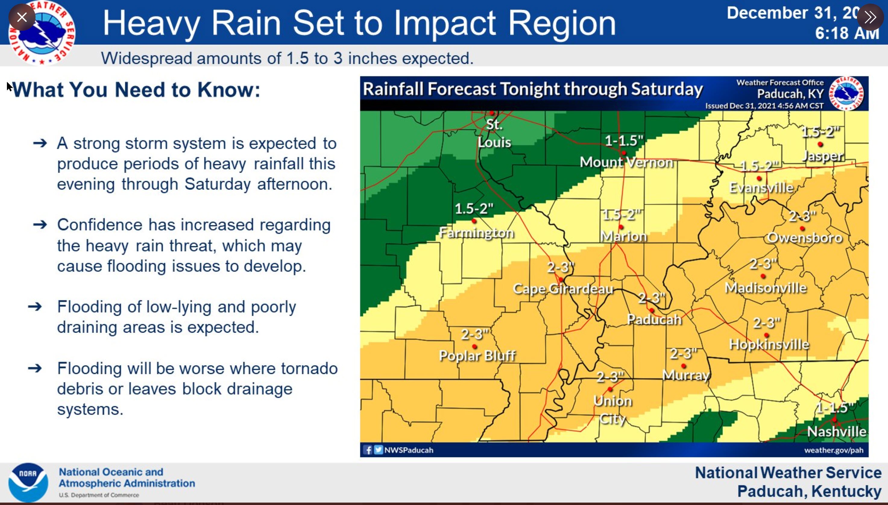
- A flood watch is in effect area-wide through Saturday. Rain totals of one to three inches will be possible.
- Have your Beau Dodson Weather app on. Check it. Make sure you have not logged out of the app.
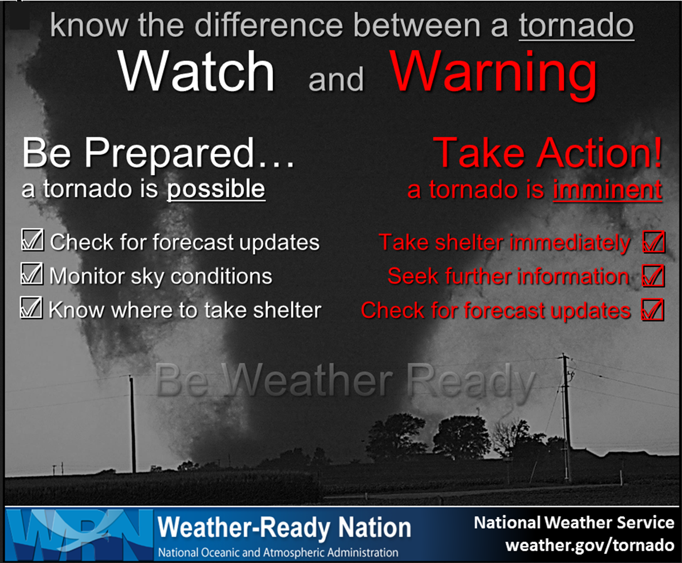
- Remember, a watch means to monitor updates. A warning means to seek shelter. A warning is a higher threat and means to seek shelter immediately. Severe weather may occur in or near your location.
.

Here is Facebooks’ Severe Weather Q&A threads.
Link https://www.facebook.com/beaudodsonweather
The latest update will be posted here at the top of Beau’s severe weather blog.
.
11:37 AM
The tornado warned cell has moved out of Todd County and the tornado warning has now expired.
.
11:30 AM
Tornado Warning
National Weather Service Paducah KY
1129 AM CST Sat Jan 1 2022
The National Weather Service in Paducah has issued a
* Tornado Warning for…
Southeastern Todd County in south central Kentucky…
* Until 1145 AM CST.
* At 1128 AM CST, a severe thunderstorm capable of producing a
tornado was located near Guthrie, or 10 miles south of Elkton,
moving northeast at 65 mph.
HAZARD…Tornado.
SOURCE…Radar indicated rotation.
IMPACT…Flying debris will be dangerous to those caught without
shelter. Mobile homes will be damaged or destroyed.
Damage to roofs, windows, and vehicles will occur. Tree
damage is likely.
* This tornadic thunderstorm will remain over mainly rural areas of
southeastern Todd County, including the following locations…
Allensville.
.
11:17 AM
Tornado Warning
National Weather Service Paducah KY
1116 AM CST Sat Jan 1 2022
The National Weather Service in Paducah has issued a
* Tornado Warning for…
Southeastern Todd County in south central Kentucky…
* Until 1130 AM CST.
* At 1116 AM CST, a severe thunderstorm capable of producing a
tornado was located near Guthrie, or 7 miles south of Elkton,
moving east at 60 mph.
.
11:14 AM
.
11:10 AM
Christian and Todd Counties
The severe threat has now ended in Christian County.
The severe thunderstorm continues to move through southern Todd County. Continue to be weather aware as this thunderstorms pushes across the county.
This storm could produce a brief tornado in southern Todd County. Seek shelter if you are in the path of these thunderstorms.
Be weather aware. These storms have a history of producing high winds.
.
10:53 AM
Christian and Todd Counties
Radar shows severe thunderstorms moving into and through southern Christian County. Movement is northeast at 55 mph.
Radar also shows rotation with a storm approaching the county line from Montgomery County, Tennessee.
This storm could produce a brief tornado. Seek shelter if you are in the path of these thunderstorms.
Be weather aware. These storms have a history of producing high winds.
.
10:46 AM
Severe Thunderstorm Warning
National Weather Service Paducah KY
1047 AM CST Sat Jan 1 2022
The National Weather Service in Paducah has issued a
* Severe Thunderstorm Warning for…
Southeastern Christian County in south central Kentucky…
Southern Todd County in south central Kentucky…
* Until 1130 AM CST.
* At 1046 AM CST, severe thunderstorms were located along a line
extending from near Fort Campbell to 10 miles east of Big Rock,
moving northeast at 60 mph.
HAZARD…60 mph wind gusts.
SOURCE…Radar indicated.
IMPACT…Expect damage to roofs, siding, and trees.
.
10:43 AM
10:43 AM CST Sat Jan 1 2022
Christian and Todd Counties
Radar shows new thunderstorms moving into the southern portion of Christian County. They are moving northeast out of Tennessee.
These thunderstorms are intense and could produce strong and gusty wind, very heavy rain, and lightning.
Be weather aware. These storms have a history of producing high winds.
.
10:41 AM
10:41 AM CST Sat Jan 1 2022
Tornado warning has expired for Todd County, Kentucky.
Additional thunderstorms are possible before the cold front pushes further east.
Stay weather aware.
.
10:35 AM
Tornado warning continues for east-central Todd County until 11 am.
At 10:34 radar showed a severe thunderstorm with rotation near Elkton, moving east at 45 mph.
Seek shelter if you are in the path of this possible tornado.
.
10:28 AM
1028 AM CST SAT JAN 1 2022

THE NATIONAL WEATHER SERVICE IN PADUCAH HAS ISSUED A

* TORNADO WARNING FOR...
  CENTRAL TODD COUNTY IN SOUTH CENTRAL KENTUCKY...

* UNTIL 1100 AM CST.

* AT 1027 AM CST, A SEVERE THUNDERSTORM CAPABLE OF PRODUCING A
  TORNADO WAS LOCATED NEAR ELKTON, MOVING EAST AT 45 MPH.

  HAZARD...TORNADO.

  SOURCE...RADAR INDICATED ROTATION.

  IMPACT...FLYING DEBRIS WILL BE DANGEROUS TO THOSE CAUGHT WITHOUT
           SHELTER. MOBILE HOMES WILL BE DAMAGED OR DESTROYED.
           DAMAGE TO ROOFS, WINDOWS, AND VEHICLES WILL OCCUR.  TREE
           DAMAGE IS LIKELY.

* THIS TORNADIC THUNDERSTORM WILL REMAIN OVER MAINLY RURAL AREAS OF
  CENTRAL TODD COUNTY, INCLUDING THE FOLLOWING LOCATIONS... EVERETT
  AND JUSTICE.
.
10:25 AM
A tornado struck Hopkinsville, Kentucky.
Here are some damage photographs
https://www.facebook.com/whopradio/photos/pcb.5033226753377944/5033223570044929
10:07 AM
Christian and Todd Counties
Radar shows intense thunderstorms across the central/southern/eastern portion of Christian County and another cell in northern Todd County.
A tornado is possible with these thunderstorms. Seek shelter until storms exit your area.
There have been reports of wind damage in Christian County.
Be weather aware as thunderstorms move east/northeast at 55 mph.
Interactive local city-view radars. Clickable watches and warnings.
https://wtalk.co/B3XHASFZ
.
10 AM
.
Muhlenberg County
Radar shows intense thunderstorms across the southern portion of the county. There have been some wind damage reports in Christian County.
Be weather aware as thunderstorms move east/northeast at 55 mph.
Seek shelter if you feel threatened by a storm.
Interactive local city-view radars. Clickable watches and warnings.
https://wtalk.co/B3XHASFZ
.
7:30 AM
Some good news this morning.
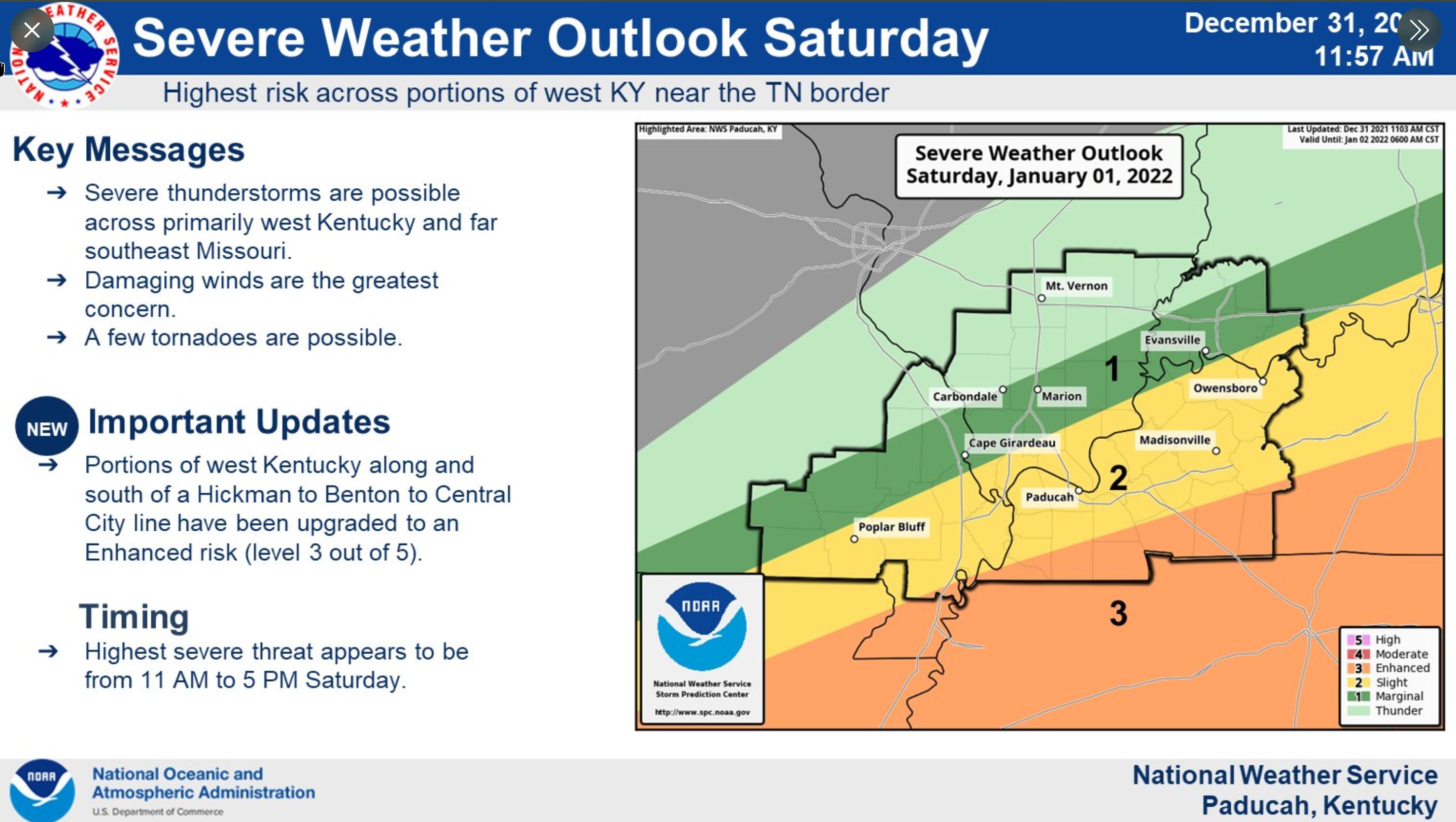
Rain cooled air has lessened the risk of severe weather today over much of the region.
The Storm Prediction Center has held onto at least some risk for our southeastern counties.
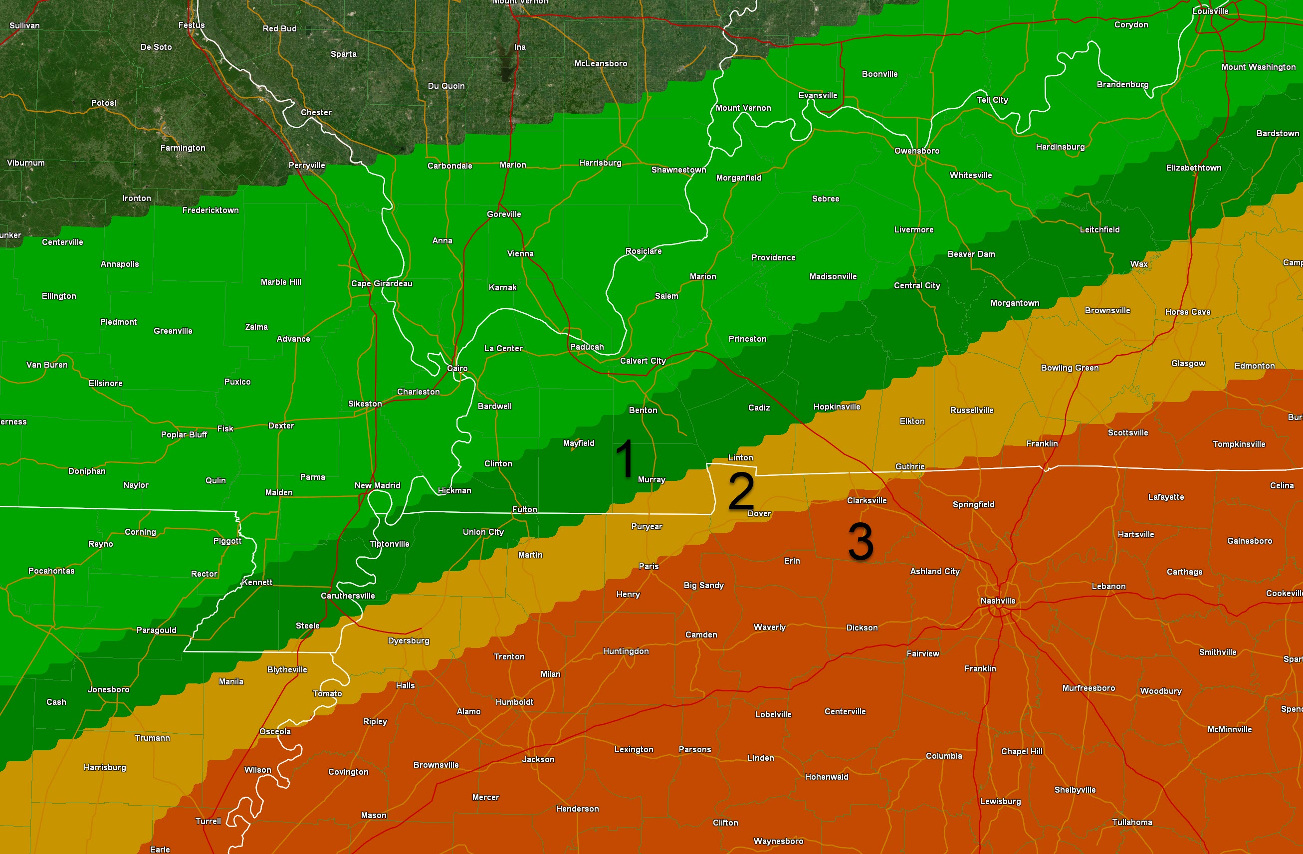
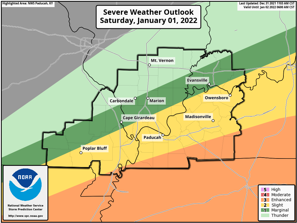
Light green represents sub-severe storms. No severe risk. Some locally heavy rain.
Dark green represents a level one risk. That is the lowest risk of severe weather.
They have pushed the level 2 and 3 risk further southeast. The level three risk is now out of my area completely.
There could be additional shifts if the rain continues. That would be great news and would bring an end to this severe weather event.
We do still have to deal with the rain. Locally heavy rain possible today. Avoid flooded roadways.
.
3:15 AM
Severe Thunderstorm Warning
The National Weather Service in Paducah has issued a
* Severe Thunderstorm Warning for…
Southeastern Christian County in south central Kentucky…
Todd County in south central Kentucky…
* Until 345 AM CST.
* At 315 AM CST, severe thunderstorms were located along a line
extending from 9 miles northeast of Hopkinsville to Pembroke to
near Fort Campbell, moving northeast at 55 mph.
Damaging wind is the main concern with this thunderstorm.
.
2:45 AM
.
Okay, regrouping here.
.
Our first patch of severe thunderstorms and tornado warned cells have weakened some over the past 20 minutes.
.
Warnings have currently expired (severe and tornado).
.
Flash flood warnings are likely tonight/today. Avoid flooded roadways.
.
Some serious flash flooding will be possible in some counties.
.
There may still be some severe thunderstorm warnings into the morning hours.
.
I believe the risk is a bit lower now than it has been over the past three hours.
.
Storms are lining out west to east and training over the same area. This represents a heavy rain threat.
.
Occasionally, some of these storms could bow outward and produce high winds.
.
The hail threat the rest of tonight should be low.
.
The tornado risk through 7 AM should be low.
.
We had that one supercell in NW TN that produced a possible tornado over the past hour or so.
.
That one has weakened.
.
We need to monitor another round of possible severe weather later this morning into this afternoon.
.
So, if you want to go to bed then leave your phones on, leave your weather radios on, and have a way to receive severe weather bulletins.
.
That is the latest update.
.
Avoid flooded roadways.
.
2:32 AM
Henry County
Eastern Calloway and southern Trigg County
The tornado warned thunderstorm has weakened some. There is no longer rotation with it.
There may still be high winds with this storm in eastern Calloway County and eastern Henry County.
The storms is moving into Trigg County, as well.
The main concern will be heavy rain, lightning, and perhaps some reports of 55 to 60 mph wind gusts.
Radars https://weatherobservatory.com/radar_paducah.htm
.
2:30 AM
Storm in Henry County has weakened. The tornado threat is likely over from that storm.
High winds still possible with the line of storms moving through eastern Calloway County and Henry County.
This storm will eventually push into Trigg County, as well.
Main concern will be strong wind gusts and heavy rain.
.
2:15 AM
Southern New Madrid County
Northern Lake County
Fulton County
Radar shows a severe thunderstorm near Peach Orchard in northern Pemiscot County. This storm is moving east/northeast at 55 mph.
This storm may produce damaging wind and hail. There is also some rotation in the storm.
.
2:05 AM
New severe thunderstorm moving into northern Dunklin and Pemiscot Counties.
.
2:02 AM
Weakley County
The severe thunderstorm has exited Weakly County. There may be additional thunderstorms overnight, but this particular storm threat has left your county.
.
Graves County
The severe thunderstorm is about to exit Graves County. There may be additional thunderstorms overnight, but this particular storm is about to leave your county.
The threat from this storm will then end.
.
1:57 AM
Eastern Weakley, northern Henry County
Southeast Graves County and Calloway County
Trigg County
Radar showed a possible tornado near Parmersville, TN. There is strong rotation with this storm.
The storm is moving northeast at 55 mph.
A tornado may be on the ground, at this time.
Kentucky counties be prepared, as well. This storm will eventually be tracking into Kentucky.
.
1:53 AM
Southeast Graves, Southern Marshall, and Calloway Counties.
A severe thunderstorm is approaching from Weakley County, Tennessee. This storm has a history of large hail and wind damage.
The storm has also occasionally been rotating and there is currently a tornado warning in Weakley and northern Henry Counties.
If the rotation continues then it may move into extreme southeast Graves County and Calloway County.
Hail and damaging wind are likely with this storm. Monitor the tornado threat, as well.
Radars https://weatherobservatory.com/radar_paducah.htm
.
1:43 AM
Weakley and northwest Henry Counties
Calloway County should also be on alert.
Radar shows a severe thunderstorm northeast of Martin, Tennessee. There is large hail with this storm and straight line winds.
Radar also shows a possible tornado northeast of Martin, Tennessee. This possible tornado is moving northeast at 55 mph.
Seek shelter if you are in the path of this storm.
Calloway County should be monitoring this storm, as well.
Radars https://weatherobservatory.com/radar_paducah.htm
.
1:39 AM
THE NATIONAL WEATHER SERVICE IN PADUCAH HAS ISSUED A

* FLASH FLOOD WARNING FOR...
  CALLOWAY COUNTY IN WESTERN KENTUCKY...
  SOUTHERN GRAVES COUNTY IN WESTERN KENTUCKY...
  SOUTHEASTERN MARSHALL COUNTY IN WESTERN KENTUCKY...
  TRIGG COUNTY IN WESTERN KENTUCKY...

* UNTIL 745 AM CST SATURDAY.
.
1:31 AM
Weakley and northwest Henry Counties
Radar shows a severe thunderstorm near Martin, Tennessee. There is large hail with this storm and straight line winds.
There has occasionally been rotation with this thunderstorms. Let’s be weather aware as it moves northeast at 55 mph.
Radars https://weatherobservatory.com/radar_paducah.htm
.
1:27 AM
Large hail moving towards Martin, TN. Could be golf ball size.
.
1:18 AM
Obion, Weakley, and northwest Henry Counties
Radar shows a severe thunderstorm in south-central Obion County.
This storm may produce ping-pong size hail. It is moving northeast at 55 mph.
Winds may also gust up to 60 mph.
Be weather aware as this storm moves northeast.
Radars https://weatherobservatory.com/radar_paducah.htm
.
12:50 AM
Lake and Obion Counties
Radar shows some rotation northwest of Dyersburg, Tennessee. This is moving northeast at 55 mph.
Wind gusts to 60 mph and quarter size hail will be possible with this line of thunderstorms.
Be weather aware as this storm moves northeast. There is some rotation with it.
Radars https://weatherobservatory.com/radar_paducah.htm
.
12:20 AM
Southeast Dunklin
Pemiscot County
Lake and Obion Counties
A line of severe thunderstorms stretched from northeast Pemiscot County southwest into southeastern Dunklin County. This line of storms was moving northeast at 50 mph.
Wind gusts to 60 mph and quarter size hail will be possible with this line of thunderstorms.
Radars https://weatherobservatory.com/radar_paducah.htm
.
12:00 AM
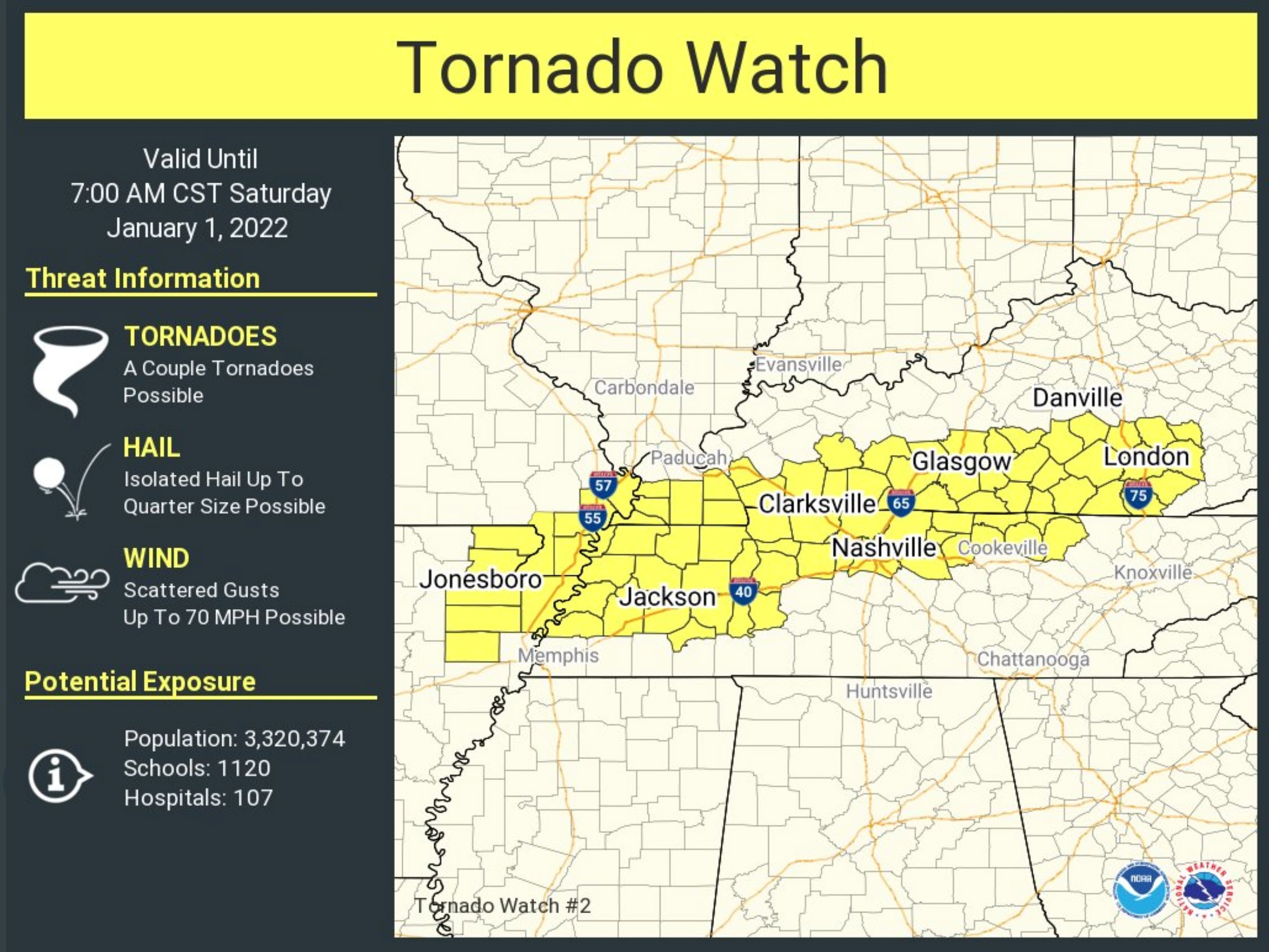
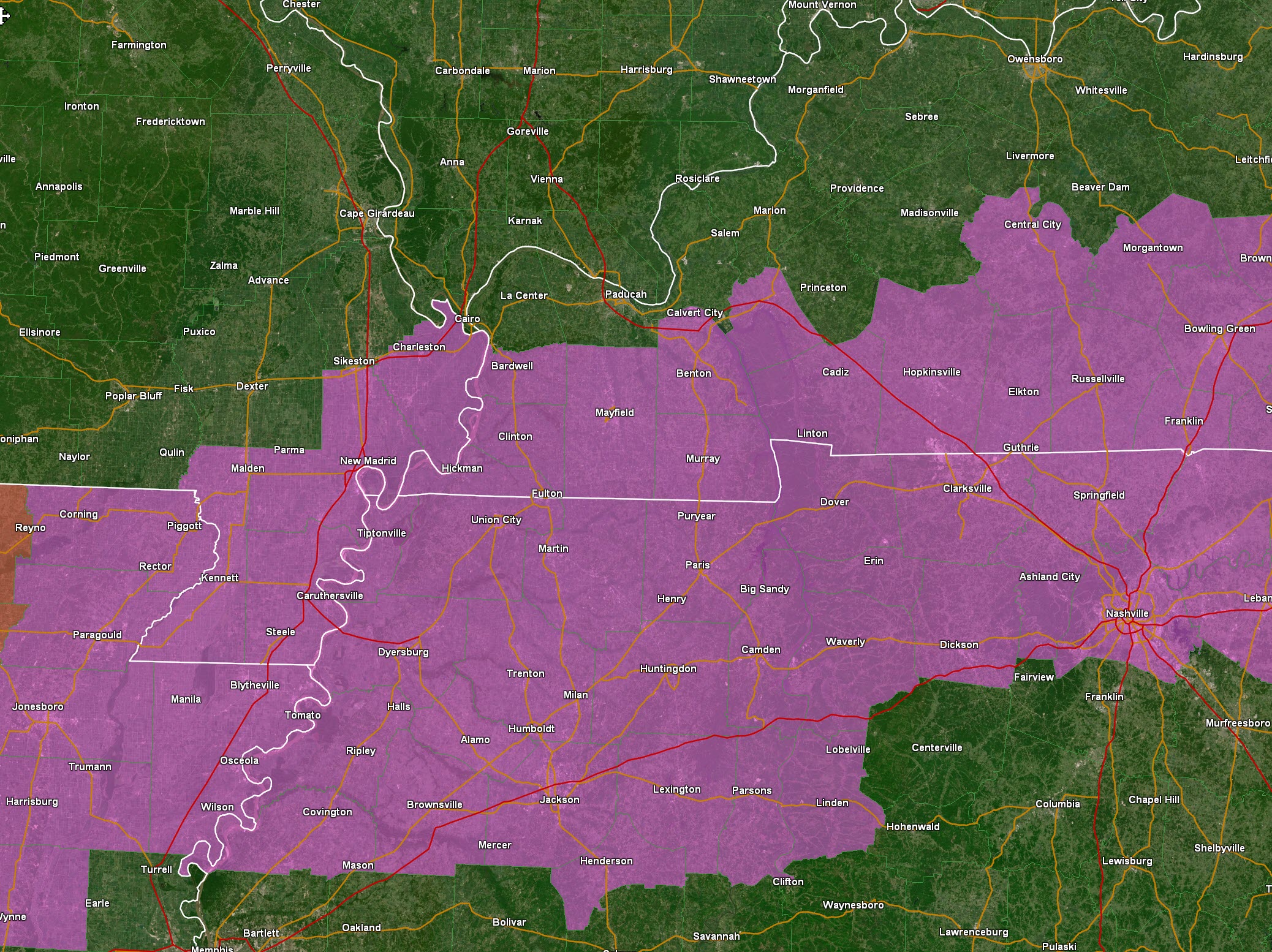
A tornado watch has been issued until 7 AM for portions of the region.
THE NATIONAL WEATHER SERVICE HAS ISSUED TORNADO WATCH 2 IN EFFECT
UNTIL 7 AM CST SATURDAY FOR THE FOLLOWING AREAS

IN KENTUCKY THIS WATCH INCLUDES 11 COUNTIES

IN WESTERN KENTUCKY

CALLOWAY              CARLISLE              CHRISTIAN
FULTON                GRAVES                HICKMAN
LYON                  MARSHALL              MUHLENBERG
TODD                  TRIGG

IN MISSOURI THIS WATCH INCLUDES 2 COUNTIES

IN SOUTHEAST MISSOURI

MISSISSIPPI
NEW MADRID
DUNKLIN
PEMISCOT

THIS INCLUDES THE CITIES OF BARDWELL, BENTON, CADIZ, CHARLESTON,
CLINTON, EDDYVILLE, ELKTON, GREENVILLE, HICKMAN, HOPKINSVILLE,
MAYFIELD, MURRAY, AND NEW MADRID.

IN TENNESSEE THIS WATCH INCLUDES 16 COUNTIES

IN WEST TENNESSEE

BENTON                CARROLL               CHESTER
CROCKETT              DECATUR               DYER
GIBSON                HAYWOOD               HENDERSON
HENRY                 LAKE                  LAUDERDALE
MADISON               OBION                 TIPTON
WEAKLEY

THIS INCLUDES THE CITIES OF ALAMO, BLYTHEVILLE, BROWNSVILLE,
CAMDEN, CARUTHERSVILLE, CORNING, COVINGTON, DECATURVILLE,
DRESDEN, DYERSBURG, HARRISBURG, HENDERSON, HUMBOLDT, HUNTINGDON,
JACKSON, JONESBORO, KENNETT, LEXINGTON, MARTIN, MILAN, PARAGOULD,
PARIS, PARSONS, PIGGOTT, RIPLEY TN, TIPTONVILLE, UNION CITY,
AND WYNNE.
5:30 PM
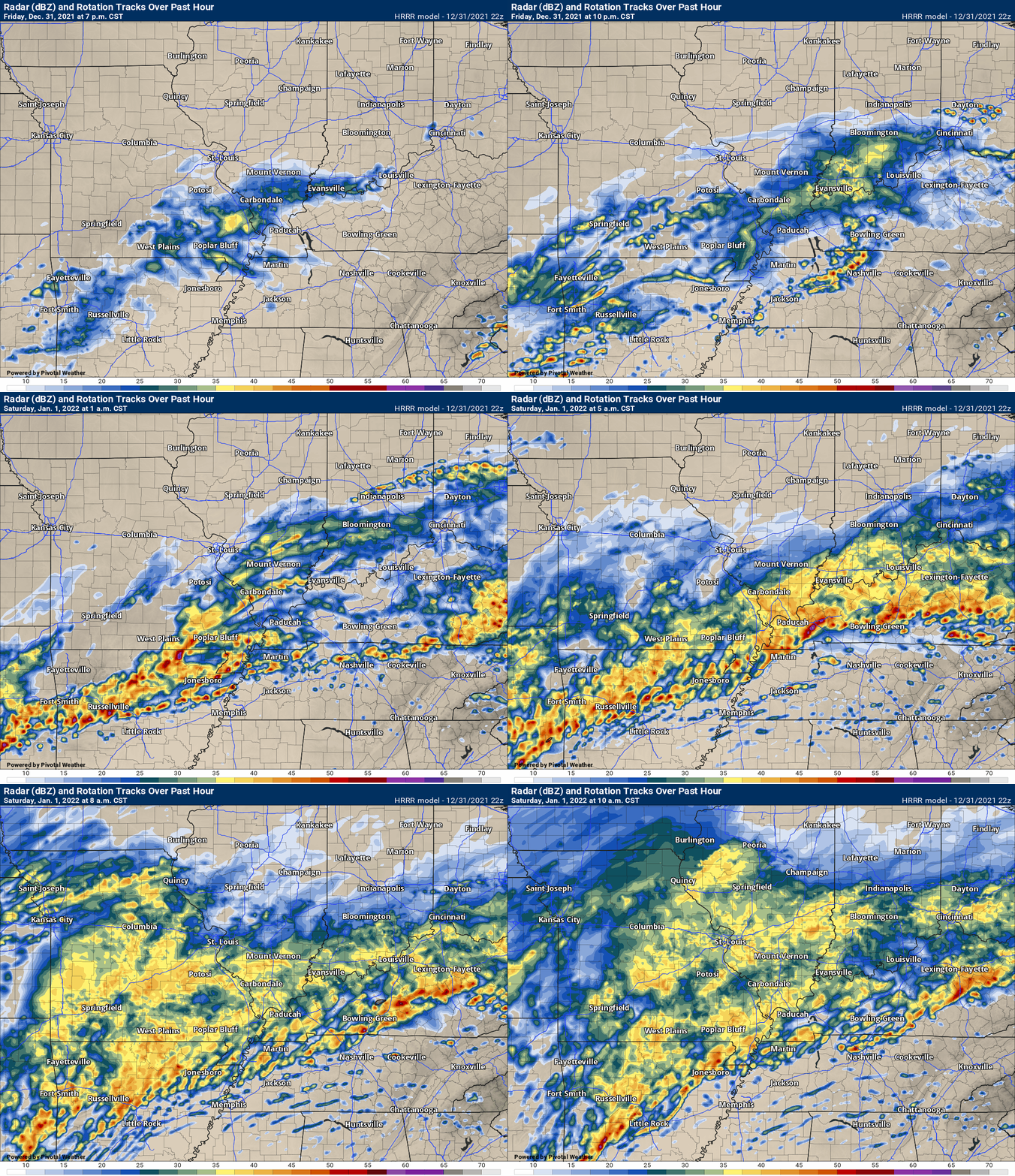
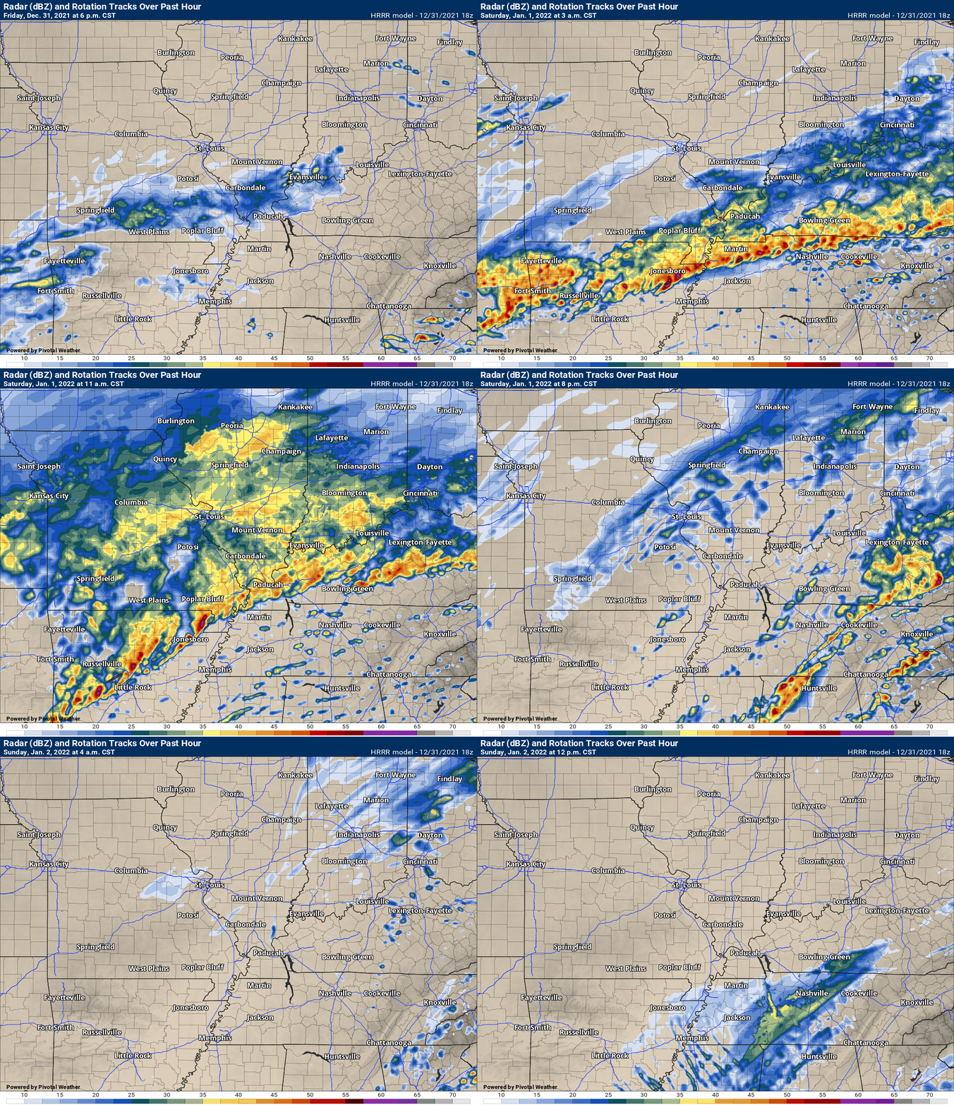
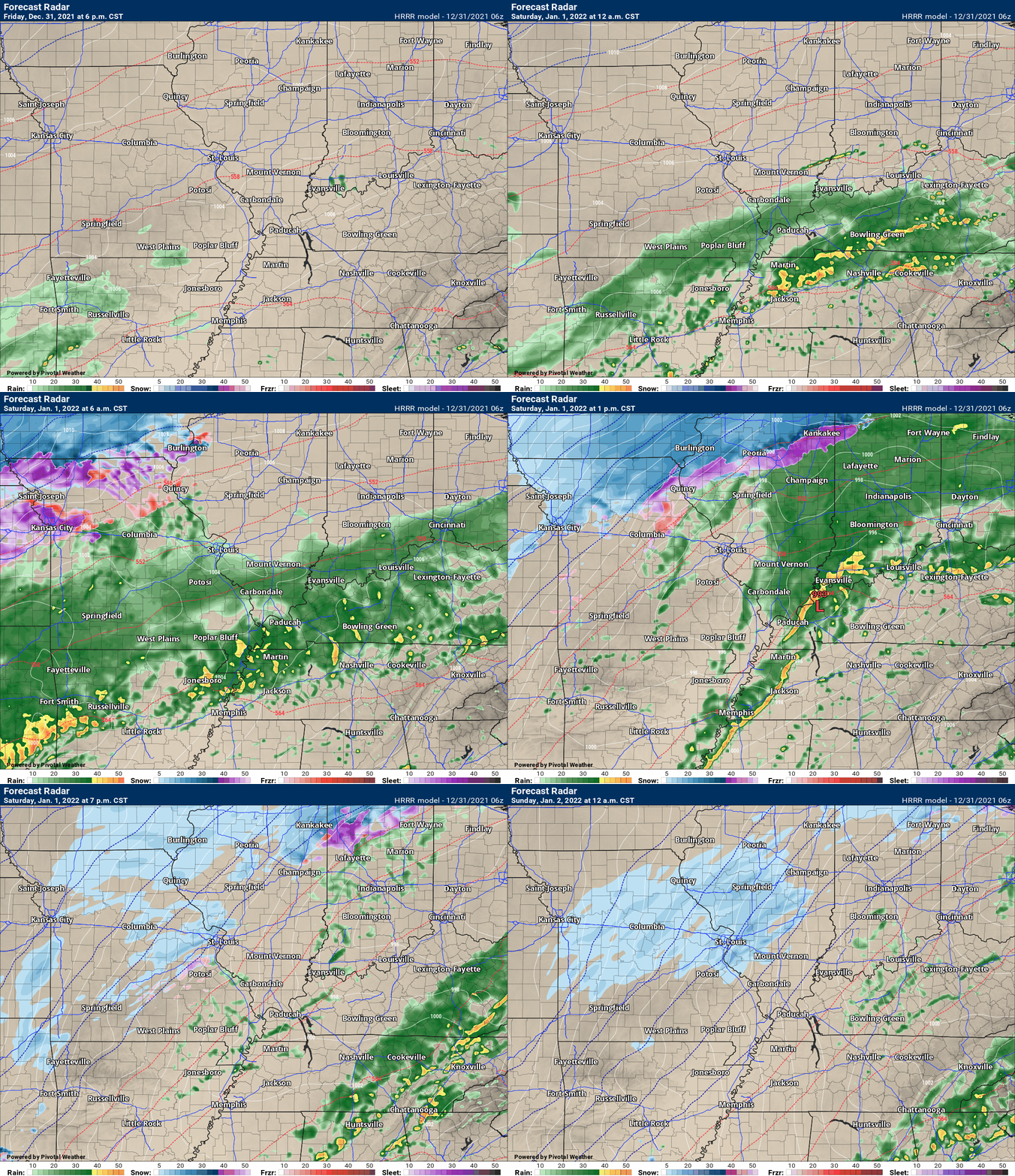
Latest Hrrr model future-cast radar.
Double-click to enlarge the animation.
You can see bands of showers and thunderstorms will rapidly develop tonight and continue into tomorrow.
Rain rates of over an inch an hour will be possible, at times.
There will also be a risk of a few storms becoming severe later tonight into tomorrow morning (and afternoon).
One time-frame of concern will be around 2AM to 7 AM.
5:30 PM
No significant changes to the going forecast.
Heavy rain is likely tonight into tomorrow.
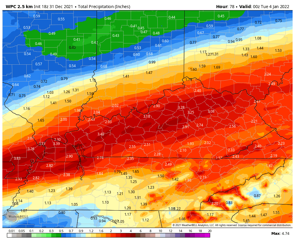
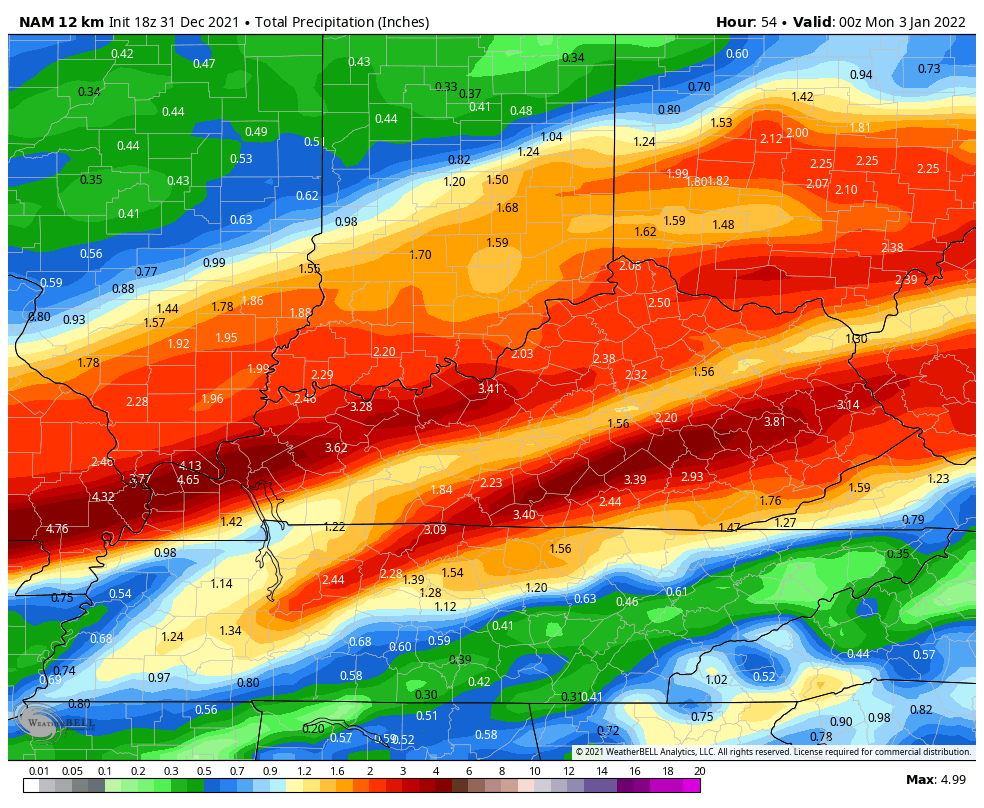
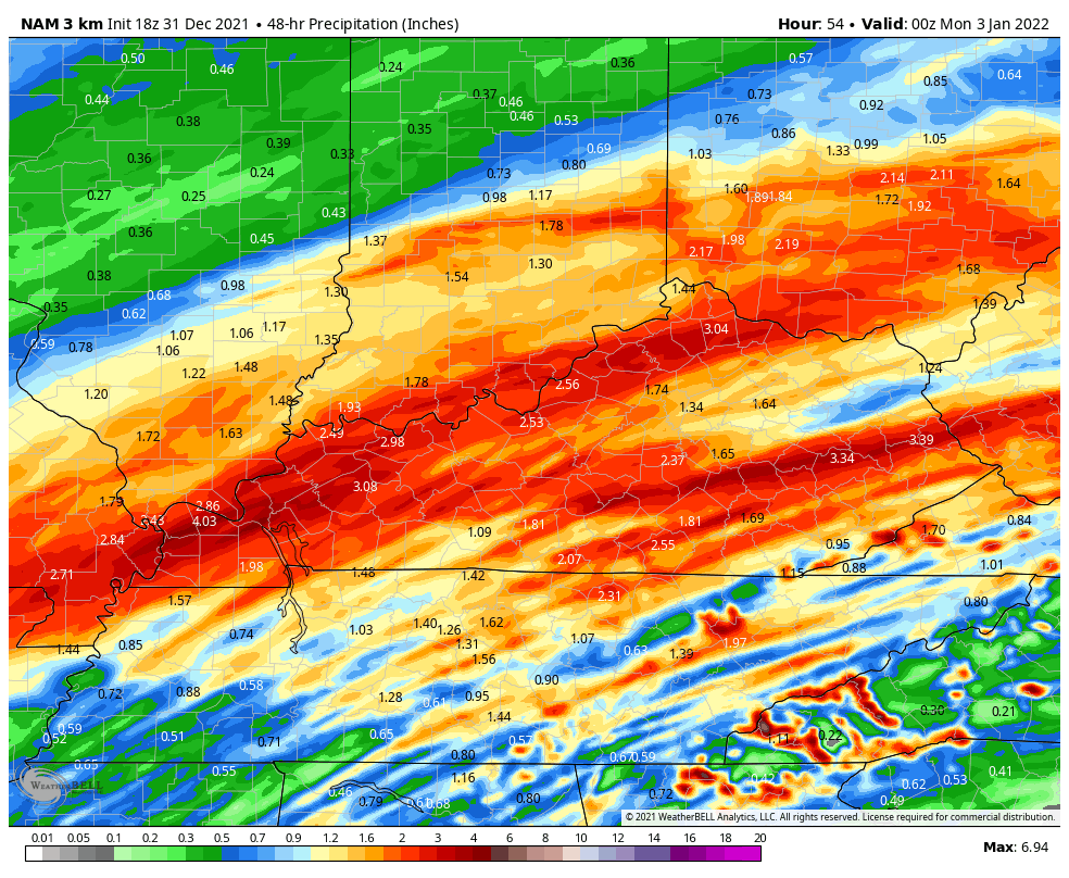
Here are the latest models and WPC forecast for rain totals.
As you can see, some big totals are possible.
WPC/NOAA forecast. Updated.
NAM 12 KM Model
NAM 3K Model
2:15 PM
Here is the latest Hrrr model future-cast radar. You can see rounds of showers and thunderstorms developing mainly tonight into tomorrow afternoon.
The Saturday late morning and afternoon storms have the highest chance of producing severe weather.
.
12:15 PM
Double click to enlarge images.
.
12 PM update
The latest day two severe weather outlook has shifted the level three threat zone northward by a few counties.
Remember, it does not matter which color zone severe weather occurs in. Severe weather is severe weather. Whether that happens in the level one zone or level three zone.
The primary concern will be damaging wind gusts and perhaps short-lived tornadoes.
Locally heavy rain is likely with this event.
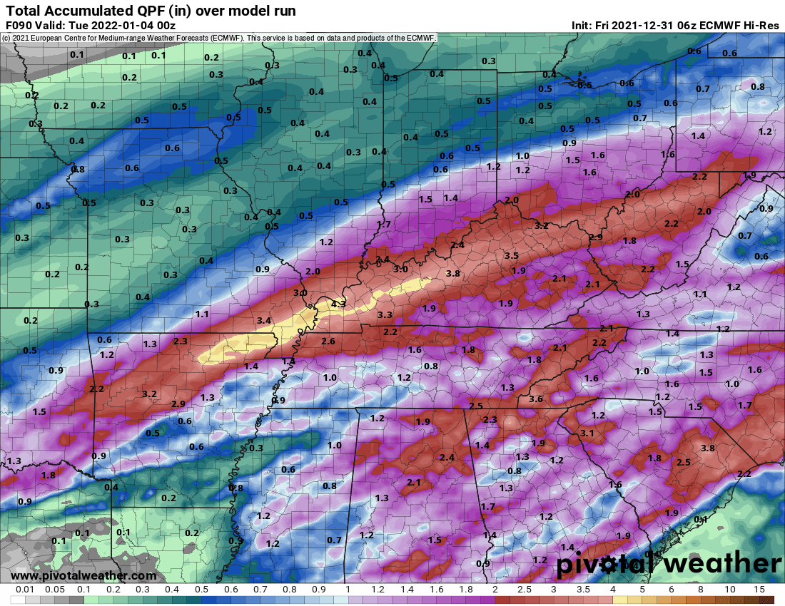
The EC model dumps a lot of rain in our region. One to two inches is likely with pockets of greater than two inches possible.
Double click to enlarge images.
.
.
10 AM update
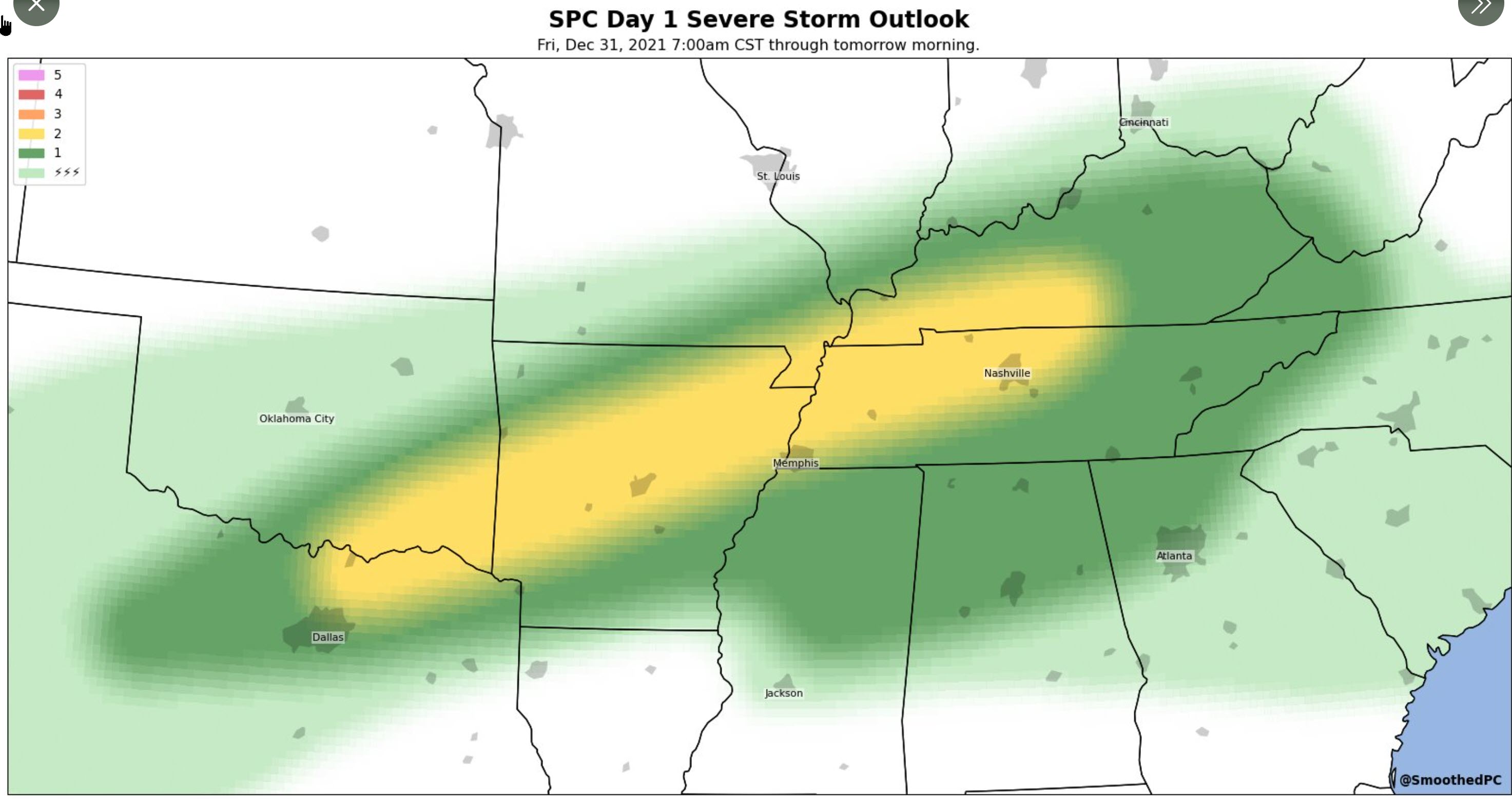
Here is the current SPC severe weather outlook. Light green is sub-severe storms. Dark green is a level one risk (lowest). Yellow is a level two risk. The main concern will be tonight after midnight.
.
8 AM update
** Severe thunderstorms are possible late Friday night into Saturday afternoon **
** The risk appears to be higher Saturday vs Friday night **
** Locally heavy rain could cause some flooding issues **
.
.
Tonight through Saturday afternoon.
Thunderstorms will develop tonight. A few of the storms could produce locally heavy rain, lightning, and gusty winds. There is a chance of a few short-lived tornadoes, as well. The tornado risk appears to be higher Saturday vs tonight.
The concern tonight will likely be after 11 PM.
There remain some differences in the model guidance as to where the area of low pressure will track. The key to the severe weather forecast is the track of an area of low pressure.
If the low tracks further north then the severe weather risk will be higher. If the low tracks further south then the risk won’t be quite as high.
For now, I am monitoring trends in the guidance.
The risk of severe weather will be higher over Kentucky and Tennessee vs Missouri and Illinois.
The time-frame of highest concern will likely be 10 AM Saturday through 4 PM Saturday. The risk is lower before that time-frame.
The primary concern will be damaging wind gusts in excess of 50 mph. There is also a chance of short-lived tornadoes. We call these QLCS tornadoes. They typically form within a line of thunderstorms.
The December 10th tornado was a long-tracked supercell tornado. This event does not look like December 10th.
QLCS tornadoes tend to last a few minutes. They tend to be EF0 and EF1 in strength.
QLCS tornadoes are a bit difficult to issue warnings on, because they develop so fast and dissipate just as fast.
Be aware of rapidly changing weather conditions tonight and Saturday. I know it is a holiday weekend and everyone will be busier than usual.
Have multiple ways of receiving severe weather information. Not just my weather app. Have other ways, as well. All technology can fail. Thus, having more than one source will help keep you safe.
Remember, a WATCH means to monitor updates. You don’t have to change your behavior for a watch. Be prepared.
A WARNINGis more serious. A WARNINGmeans severe weather is imminent in or near your location. A WARNING means to seek shelter.
.
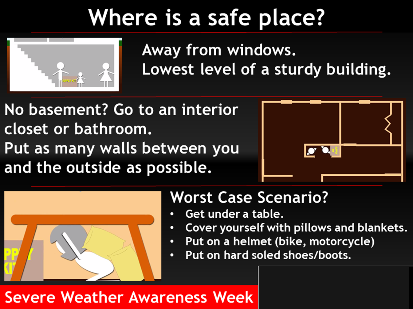
Where is a safe place to hide when tornadoes threaten your location.
.

Click here if you would like to return to the top of the page.
Again, as a reminder, these are models. They are never 100% accurate. Take the general idea from them.
What should I take from these?
- The general idea and not specifics. Models usually do well with the generalities.
- The time-stamp is located in the upper left corner.
- The EC European weather model is in Zulu time.
.
What am I looking at?
You are looking at different models. Meteorologists use many different models to forecast the weather. All models are wrong. Some are more wrong than others. Meteorologists have to make a forecast based on the guidance/models.
I show you these so you can see what the different models are showing as far as precipitation. If most of the models agree, then the confidence in the final weather forecast increases.
You can see my final forecast at the top of the page.
.
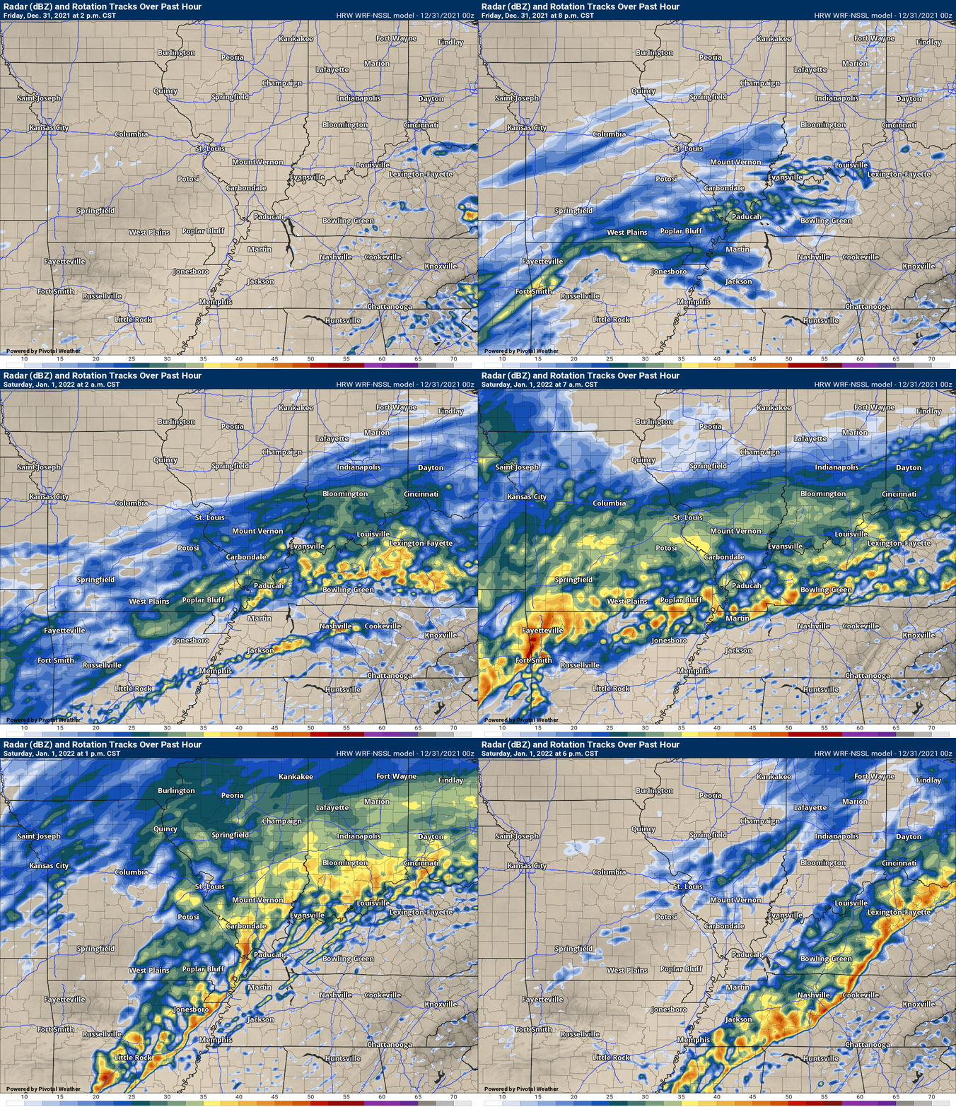
This animation is the Storm Prediction Center WRF model.
This animation shows you what radar might look like as the next system pulls through the region. It is a future-cast radar.
Time-stamp upper left. Click the animation to enlarge it.
.
This animation is the Hrrr short-range model.
This animation shows you what radar might look like as the next system pulls through the region. It is a future-cast radar.
Time-stamp upper left. Click the animation to enlarge it.
.
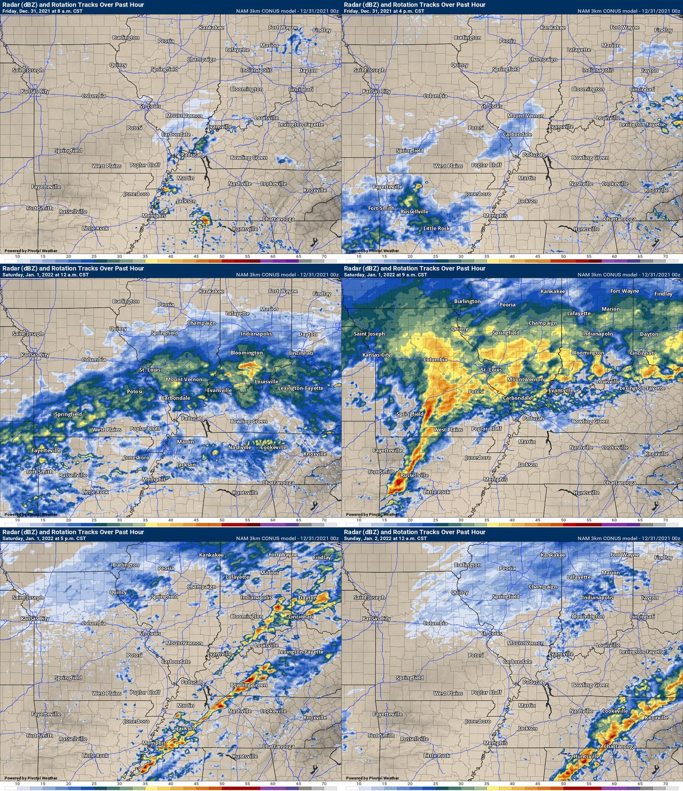
.This animation is the higher-resolution 3K NAM American Model.
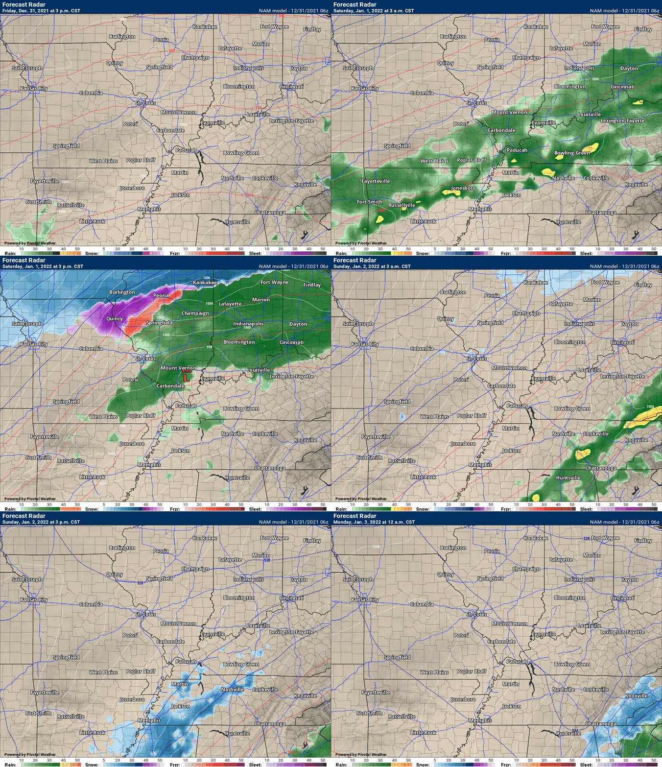
This next animation is the lower-resolution NAM American Model.
This animation shows you what radar might look like as the system pulls through the region. It is a future-cast radar.
Time-stamp upper left. Click the animation to enlarge it.
.
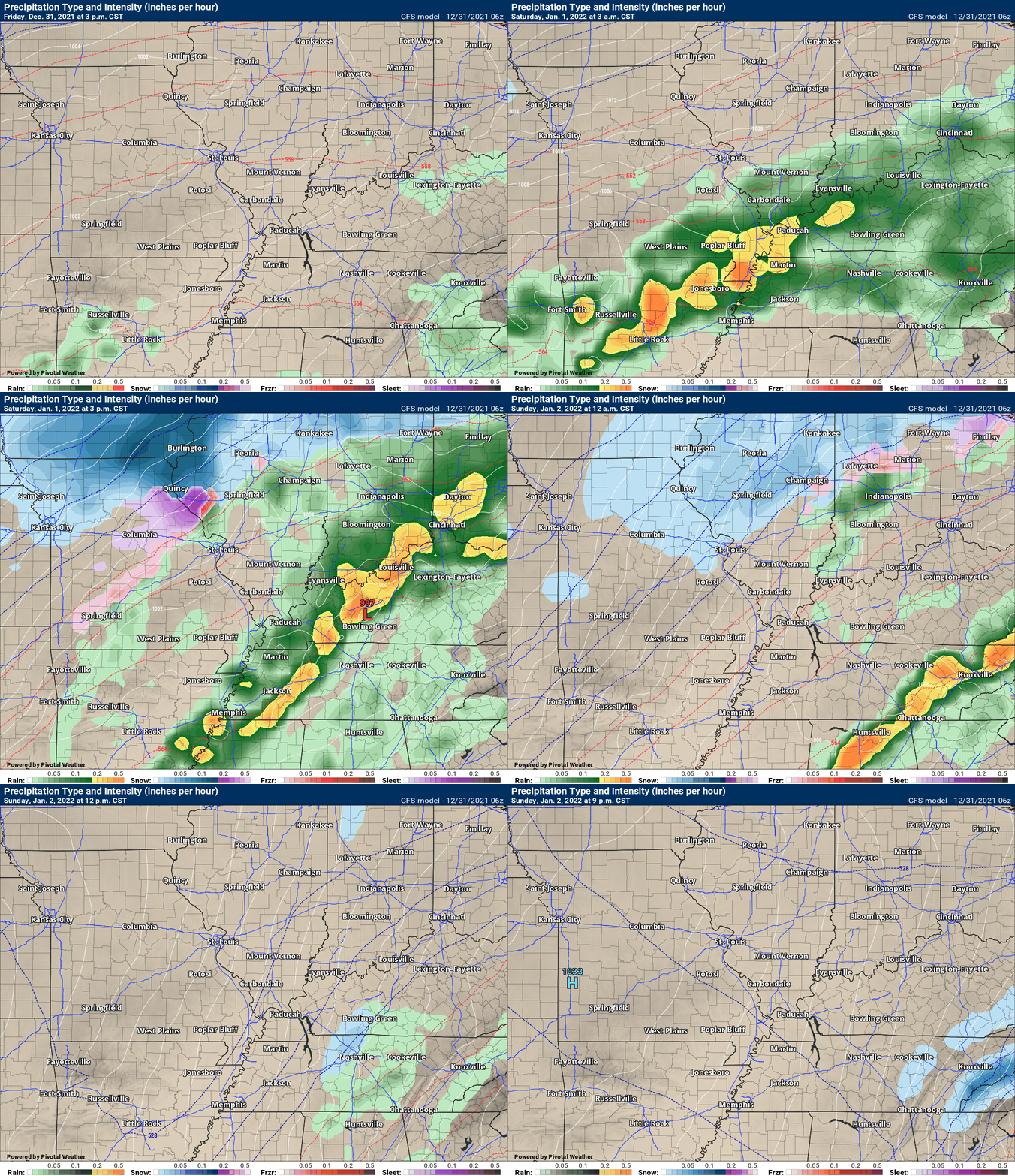
This next animation is the GFS American Model.
This animation shows you what radar might look like as the system pulls through the region. It is a future-cast radar.
Time-stamp upper left. Click the animation to enlarge it.
.
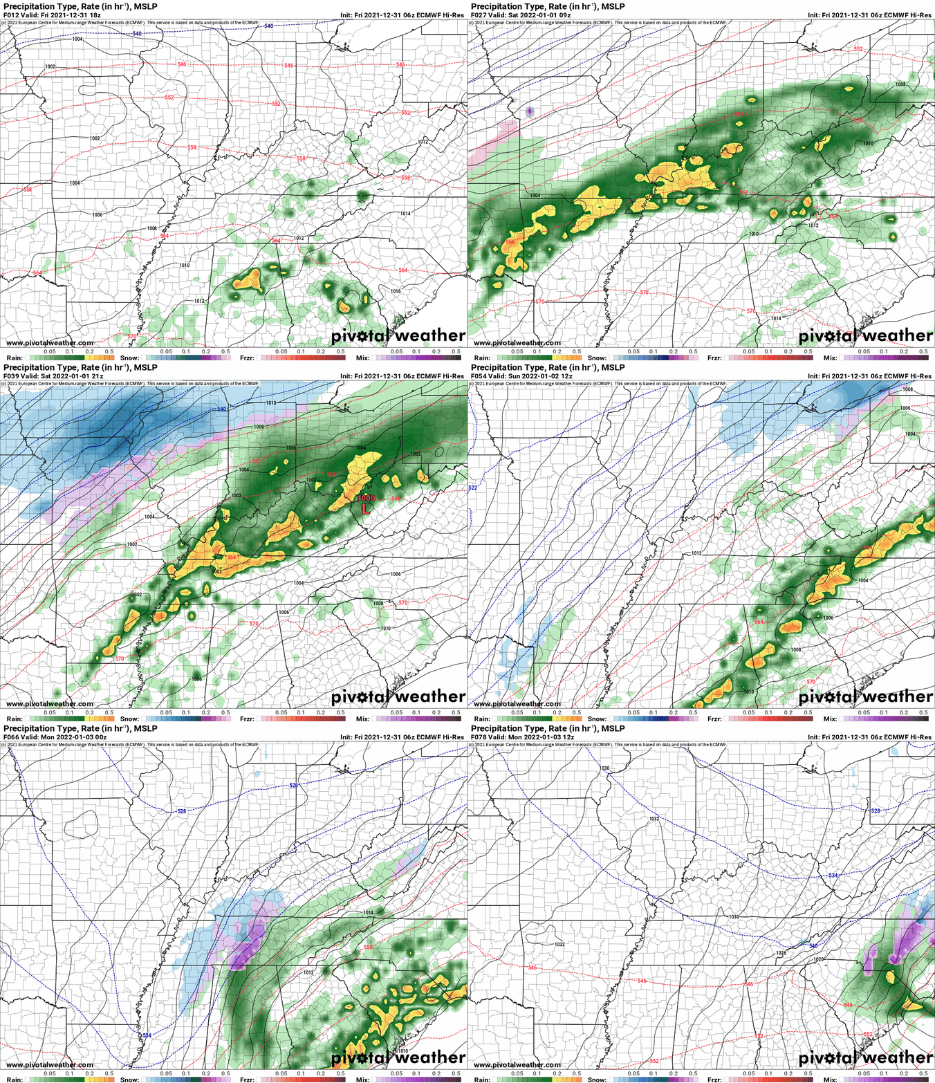
This next animation is the EC European Weather model.
This animation shows you what radar might look like as the system pulls through the region. It is a future-cast radar.
Time-stamp upper left. Click the animation to enlarge it.
Time is in Zulu. 12z=6 AM. 18z=12 PM. 00z=6 PM.
![]()
Today’s severe weather outlook from the Storm Prediction Center (below).
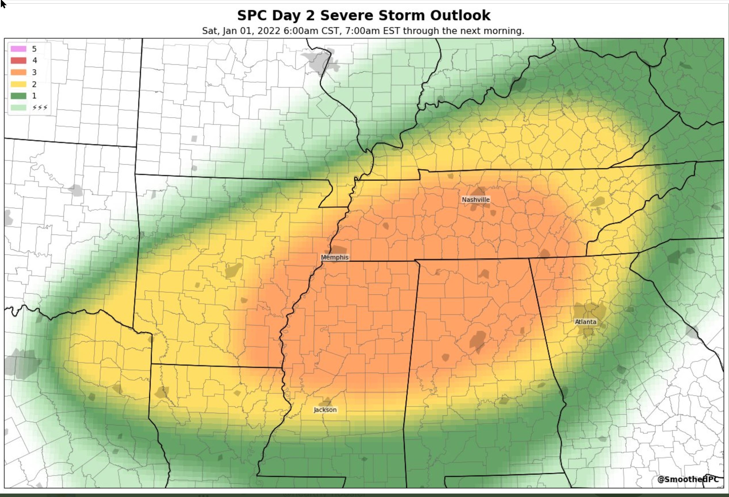
Light green is where thunderstorms may occur but should be below severe levels.
Dark green is a level one risk. Yellow is a level two risk. Orange is a level three (enhanced) risk. Red is a level four (moderate) risk. Pink is a level five (high) risk.
One is the lowest risk. Five is the highest risk.
A severe storm is one that produces 58 mph wind or higher, quarter size hail, and/or a tornado.
The tan states are simply a region that SPC outlined on this particular map. Just ignore that.

The black outline is our local area.

.
Tomorrow’s severe weather outlook.

.
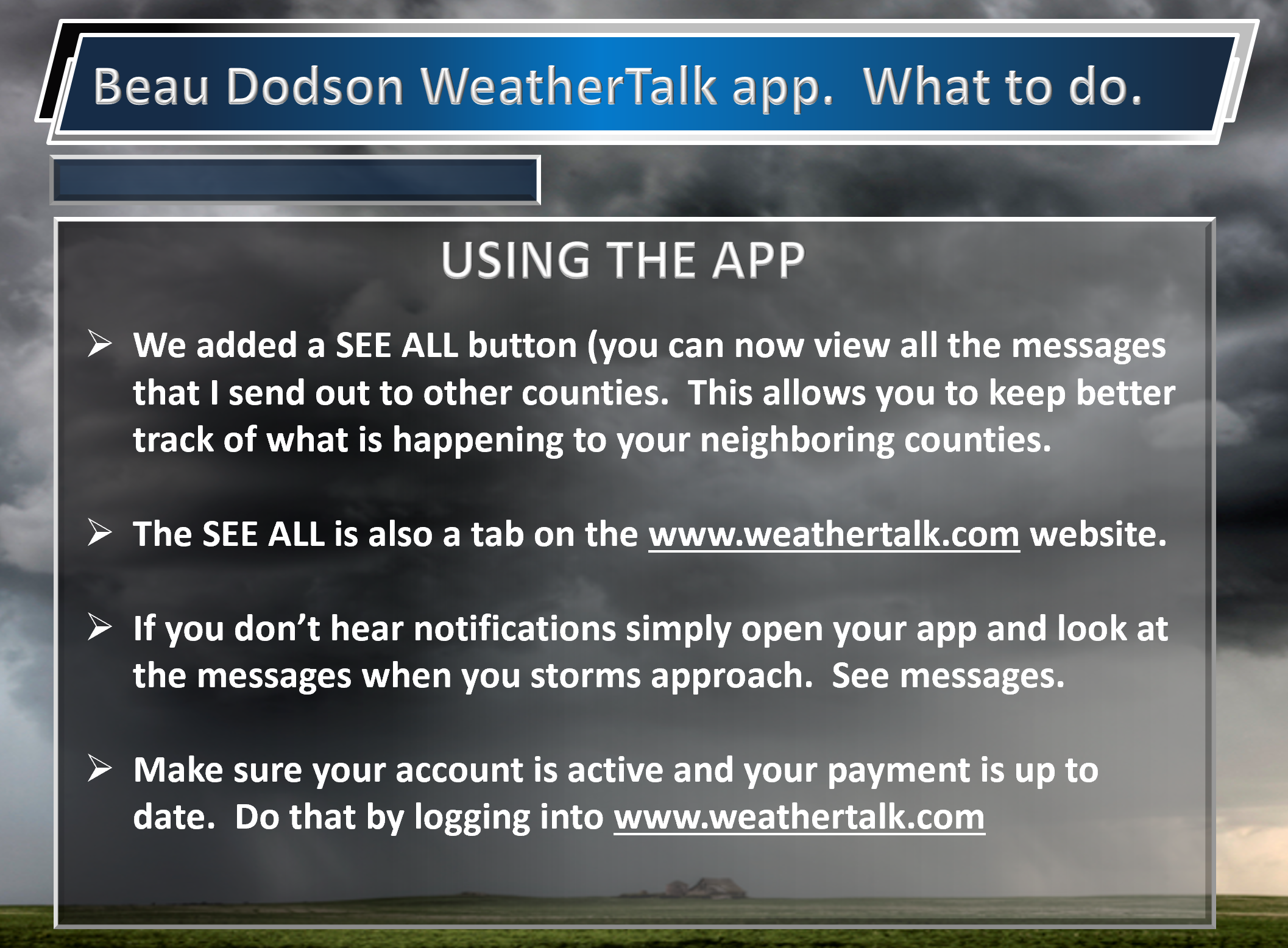
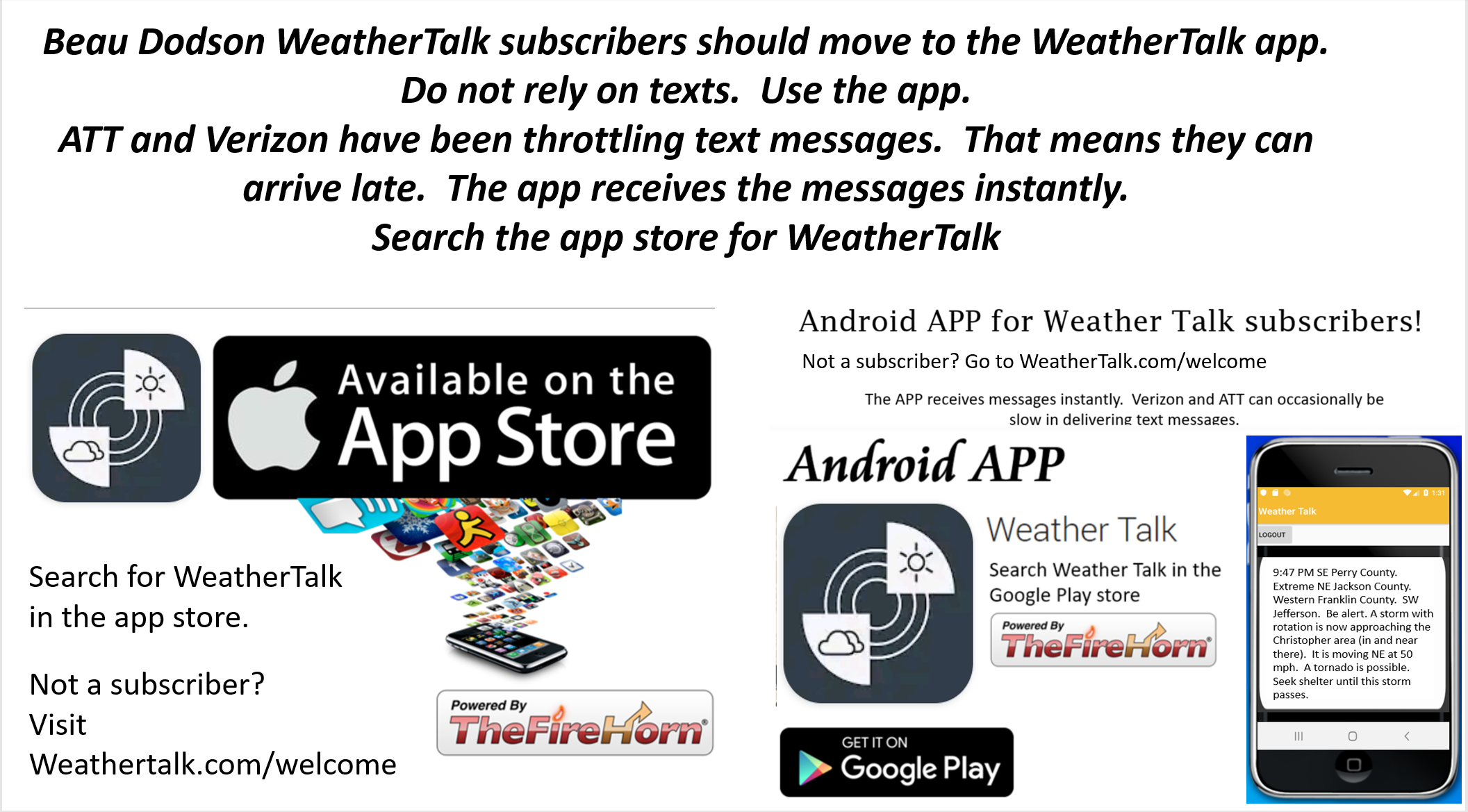
SUBSCRIBERS: Download the WeatherTalk app to keep abreast of my latest information.
The app is for subscribers. Subscribe at www.weathertalk.com/welcome then go to your app store and search for WeatherTalk
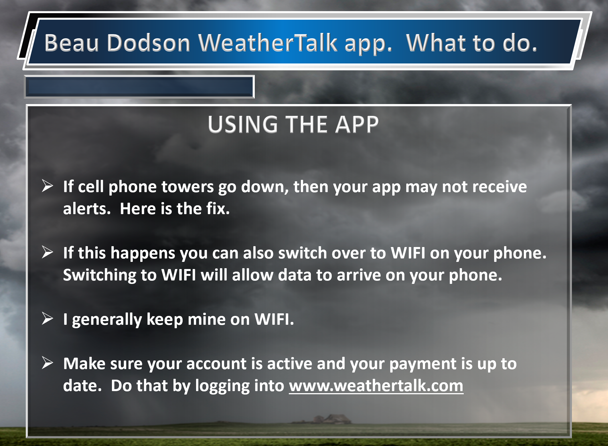
Subscribers, PLEASE USE THE APP. ATT and Verizon are not reliable during severe weather. They are delaying text messages.
The app is under WeatherTalk in the app store.
Apple users click here
Android users click here
![]()
![]()
.

Radar Link: Interactive local city-view radars & regional radars.
You will find clickable warning and advisory buttons on the local city-view radars.
If the radar is not updating then try another one. If a radar does not appear to be refreshing then hit Ctrl F5. You may also try restarting your browser.
Not working? Email me at beaudodson@usawx.com
Backup radar site in case the above one is not working.
https://weathertalk.com/morani
New ZOOM radar (with storm chasers)
https://wtalk.co/AVWG7GM7
Regional Radar
https://imagery.weathertalk.com/prx/RadarLoop.mp4
Lightning Data (zoom in and out of your local area)
https://wtalk.co/WJ3SN5UZ
Satellite Data
Computers and tablets. These two satellite links may not work well on cell phones.
Visible Satellite. This one is to be used during daylight only. Be sure and hit refresh once you are on the satellite page. Otherwise, the data will be old.
https://col.st/a5A0e
IR Satellite. This one shows cloud temperatures. Bright colors represent cold cloud tops. That could mean thunderstorms. Be sure and hit refresh once you are on the satellite page. Otherwise, the data will be old.
https://col.st/R2fw1
Water Vapor Satellite. This one shows mid-level moisture in the atmosphere. Be sure and hit refresh once you are on the satellite page. Otherwise, the data will be old.
https://col.st/xFVwx
.

Live lightning data: Click here.
Not receiving app/text messages?
Log in and out of your app.
USE THE APP. ATT and Verizon are slowing or stopping the text messages. Move to the app (not texts).
Make sure you have the correct app/text options turned on. Find those under the personal notification settings tab at www.weathertalk.com. Red is off. Green is on.
Subscribers, PLEASE USE THE APP. ATT and Verizon are not reliable during severe weather. They are delaying text messages.
The app is under WeatherTalk in the app store.
Apple users click here
Android users click here
.


