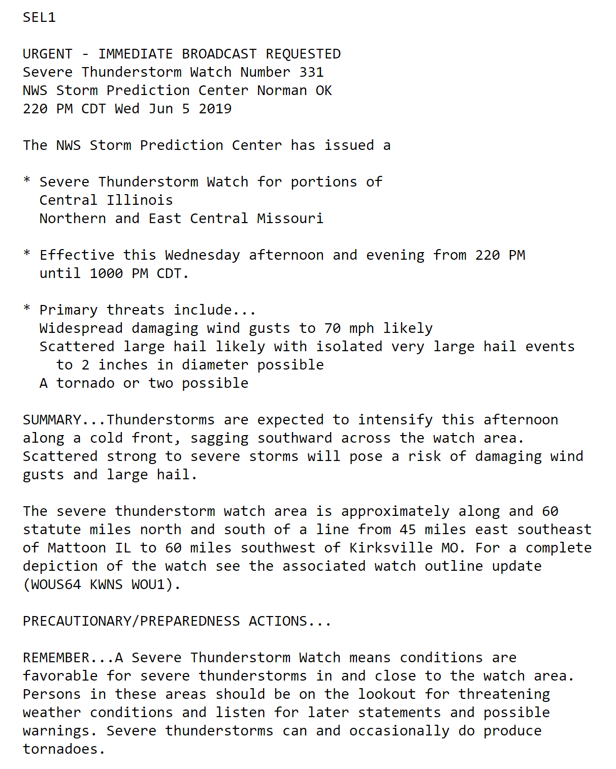
June 4, 2019
BEGIN LIVE BLOG
.
County Maps: Click Here
FACEBOOK Q&A LINK
CLICK HERE
Live-interactive radars: Click here
Regional radar link: Click here
Live lightning data: Click here.
Additional storm tracking tools can be found at the bottom of the page.
.
.
10:00 PM
Storms continue to move southward. The risk of severe storms the rest of tonight is low.
Heavy rain is the main concern. If storms train over the same area then very heavy rain will occur.
Additional storms are possible tomorrow into the weekend.
9:00 PM

.
8:50 PM
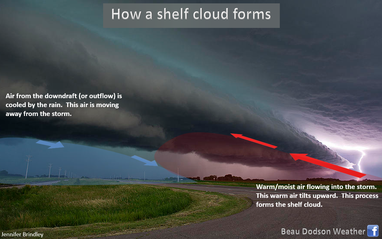
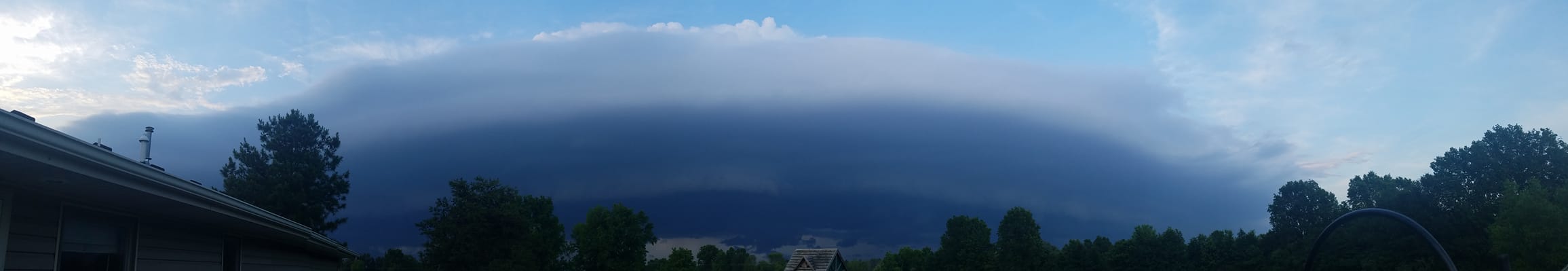
Many of you are seeing shelf clouds. These are caused by rain-cooled air surging forward into the warm/moist air.
Gusty winds accompany them. Rain is behind them.
Ashley Dial took this photograph along the Franklin/Williamson County line in southern Illinois.

.
7:25 PM
Storms slowly moving southward through and into Randolph, Perry, Jefferson, Franklin, Hamilton, and Wayne. Torrential rain could cause flooding. Isolated 50 mph wind gusts, as well.
County Maps: Click Here
.
7:23 PM
NWS issues Areal Flood Advisory for Jefferson [IL] till 10:15 PM CDT
.
7:10 PM
The line of storms is beginning to shift southward a bit faster.
The main concern will be torrential rain, frequent lightning, and gusty winds. Small hail, as well.
Some severe thunderstorm warnings are possible.
Live-interactive radars: Click here
.
6:41 PM
Heavy storms in Jefferson County, Illinois. These storms are slowly been moving southward. Flash flooding is a concern as the storms are produced one to three inches of rain per hour.
Live radar
http://weatherobservatory.com/radar_mtver.htm

.
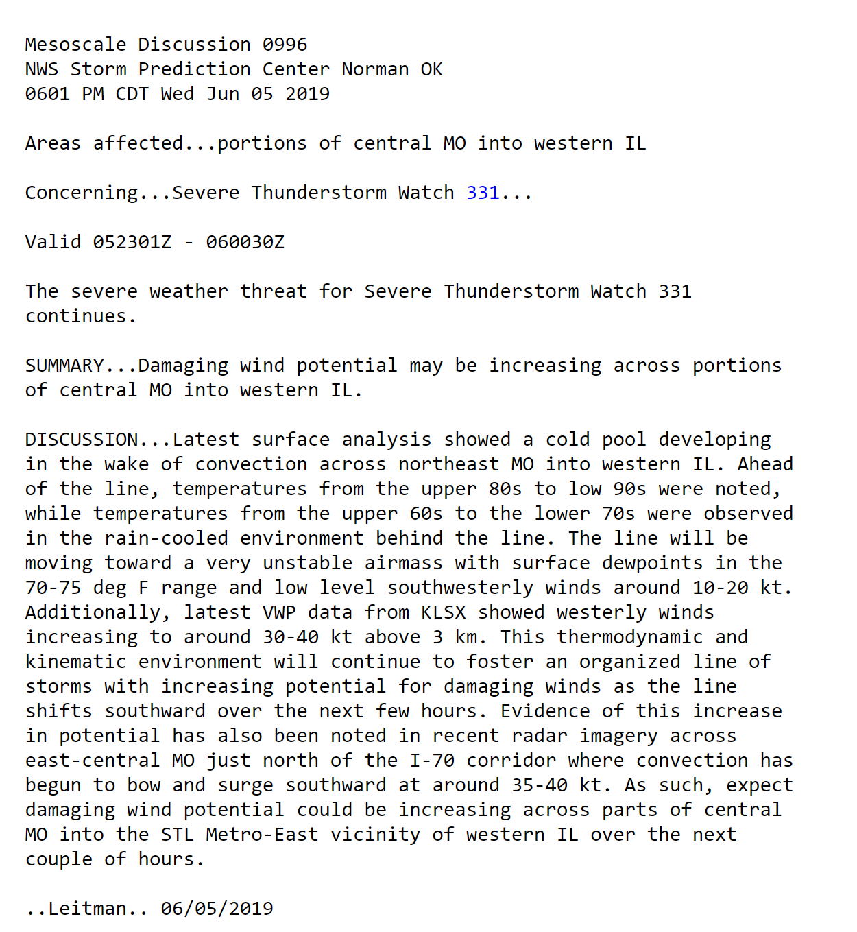
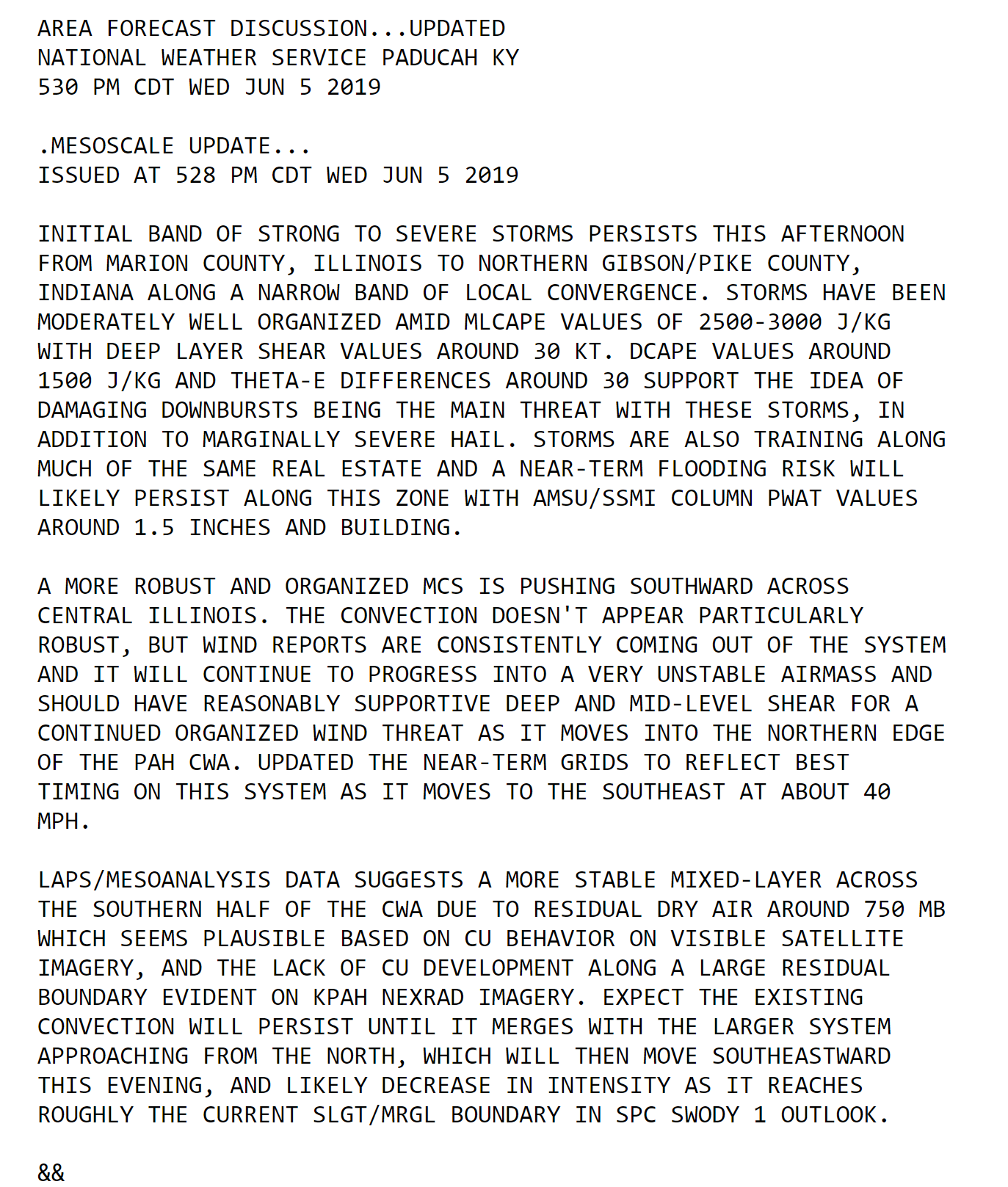
6:06 PM
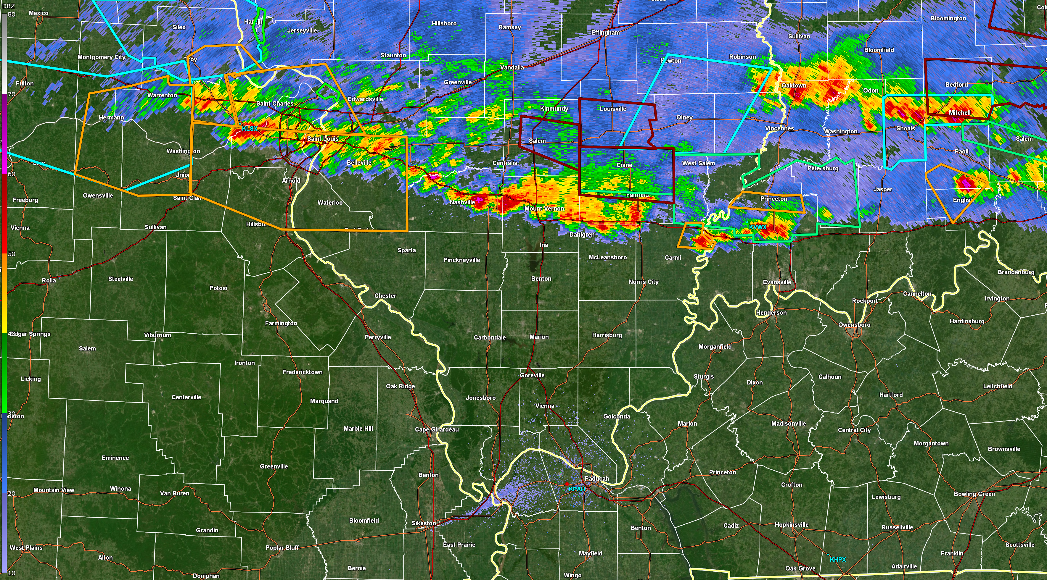
Line of severe storms across Missouri, Illinois, and Indiana. Slowly moving southward.
Regional radar link https://imagery.weathertalk.com/prx/RadarLoop.mp4
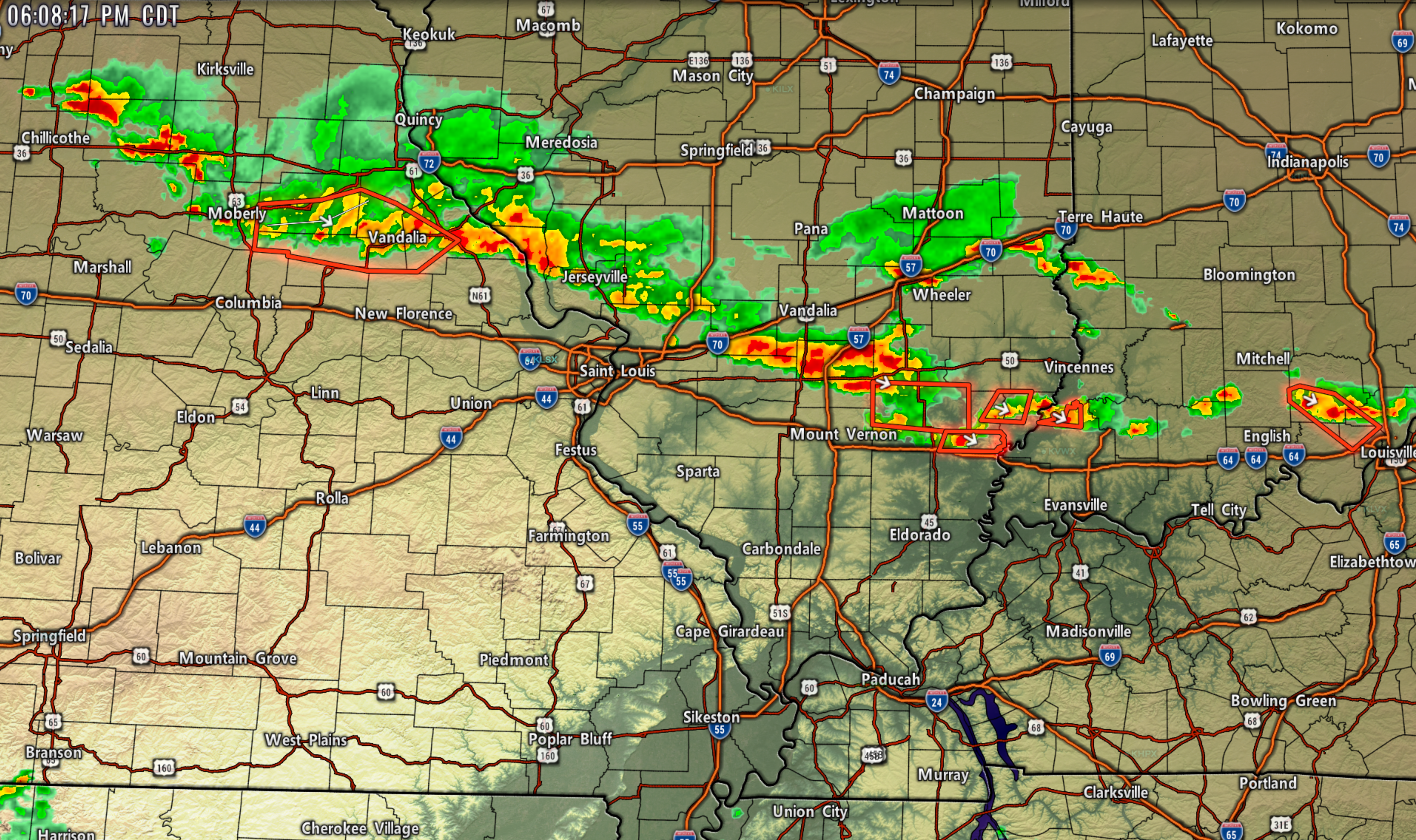
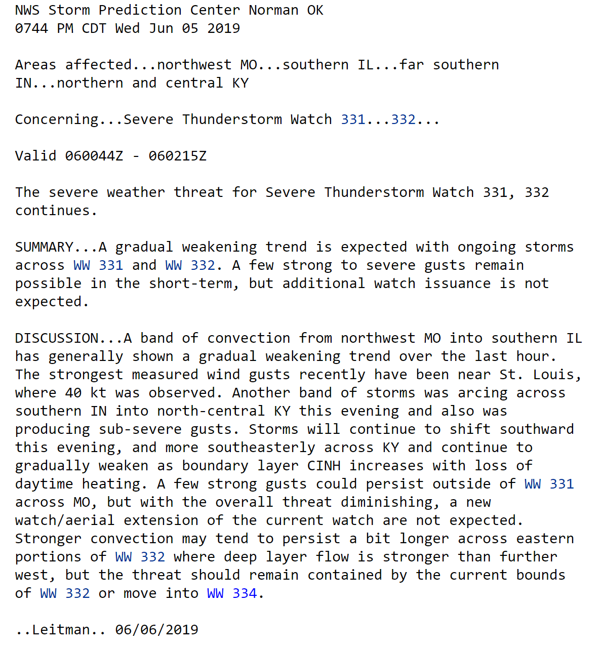
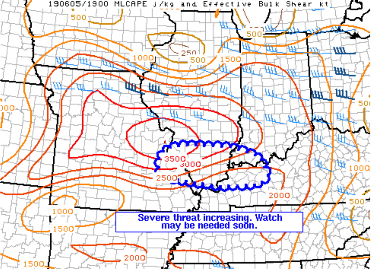
Here is an updated discussion concerning the storms moving towards St Louis and then moving southeast from there.
Click images to enlarge.
.
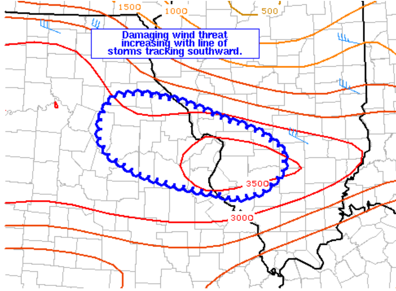
5:32 PM
Mesoscale update concerning the next few hours.
.
4:52 PM
Local Storm Report by NWS Paducah: 8 NW Johnsonville, Illinois [Wayne Co, IL] trained spotter reports TSTM WND GST of E60 MPH at 04:45 PM CDT
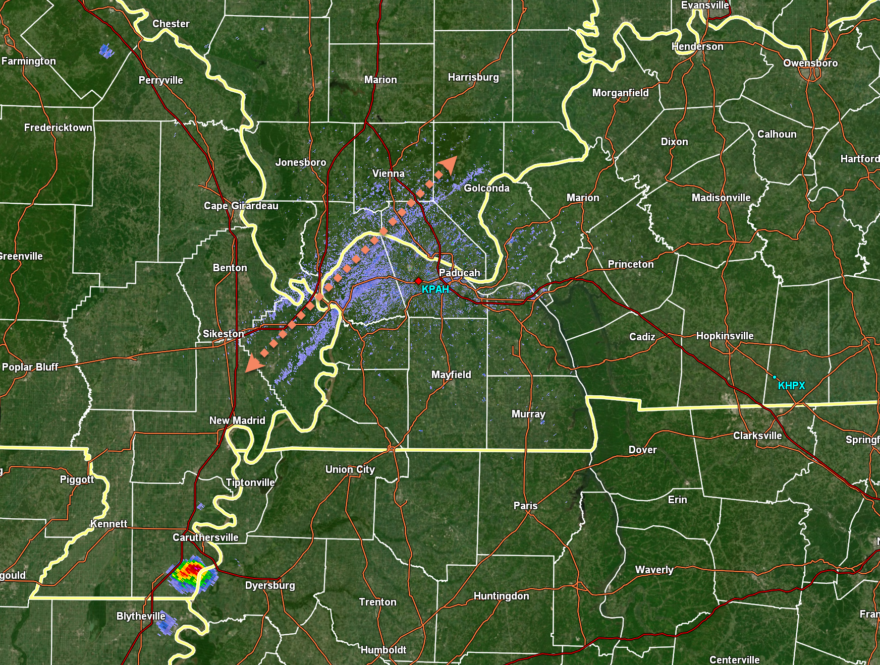
I am monitoring a boundary on the radar. Sometimes these boundaries can be the focal point of new storm development.
You can see it here on the Paducah, Kentucky, NWS radar.
Also, notice one storm in the Missouri Bootheel.
.
4:22 PM
Jefferson County. I am watching storms just to your north. Very slowly moving S SE. Once they arrive they could produce hail and high wind. Monitor updates.
.
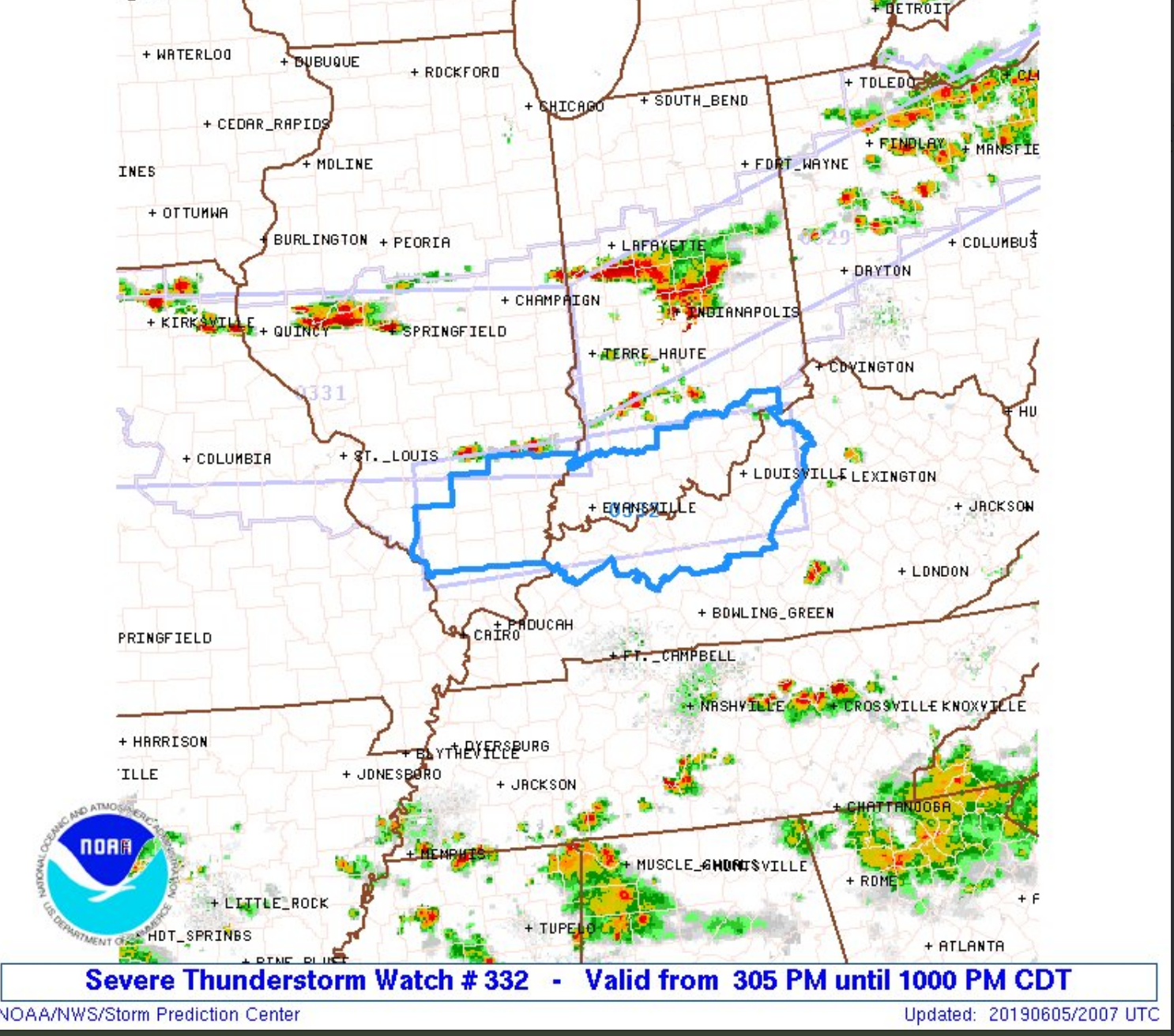
3:36 PM
Severe thunderstorm watch box
Click on images and text to enlarge
.
A second watch box is located off the west/northwest.
That does include Randolph County, Illinois, in my forecast zone.

.
.
3:11 PM
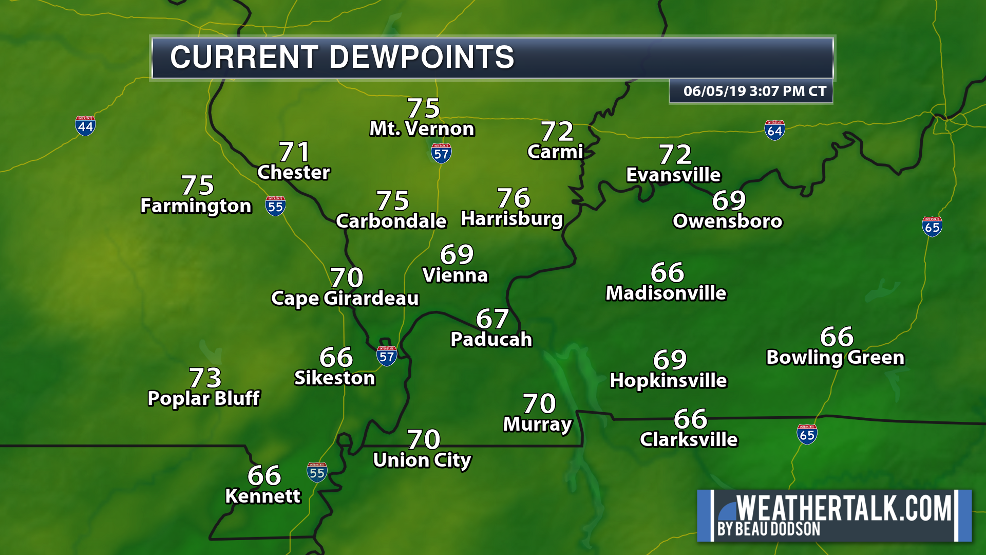
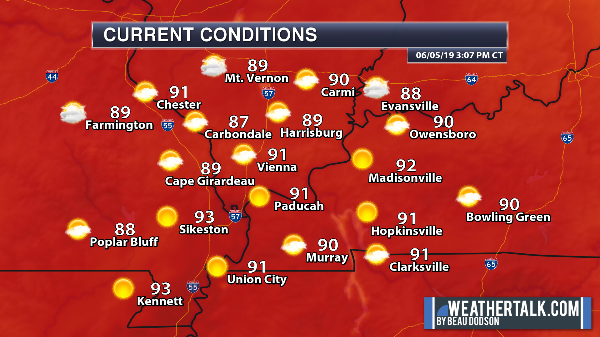
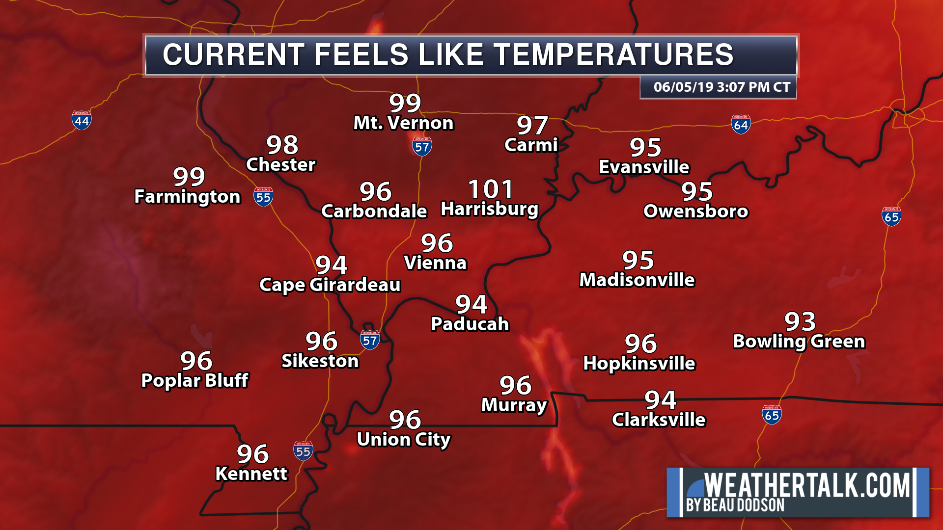
It is hot and muggy across the region. We have summer like dew point temperatures. Some locations are above 100 on the heat index scale.
This is providing plenty of fuel for the development of thunderstorms over the coming hours. The main concern will be across the northern half of southeast Missouri, the northern two-thirds of southern Illinois, and northwest Kentucky.
Areas to the south should closely monitor updates, as well.
Scroll down for additional posts.
Current dew points
.
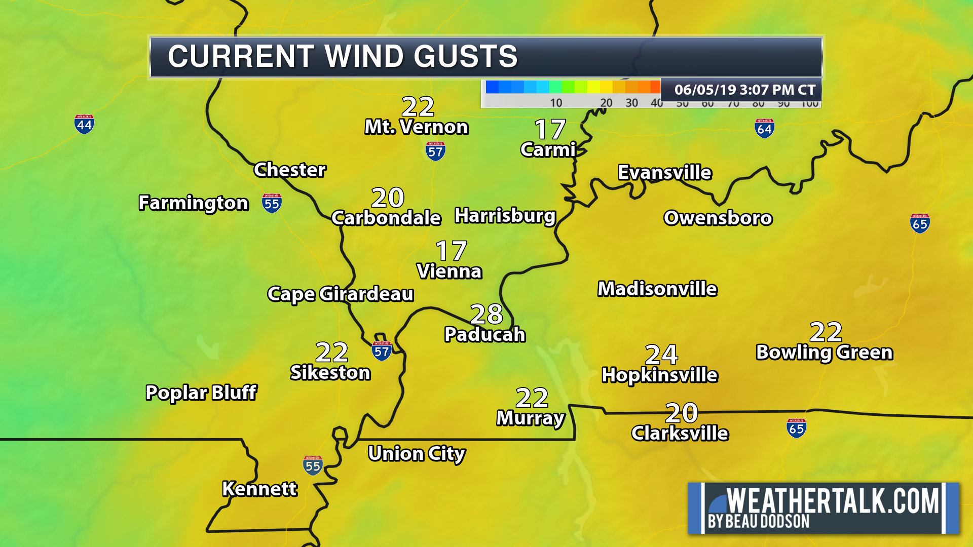
Current temperatures
.
Current feels like temperature
.
Current wind gusts
.
Radar

.
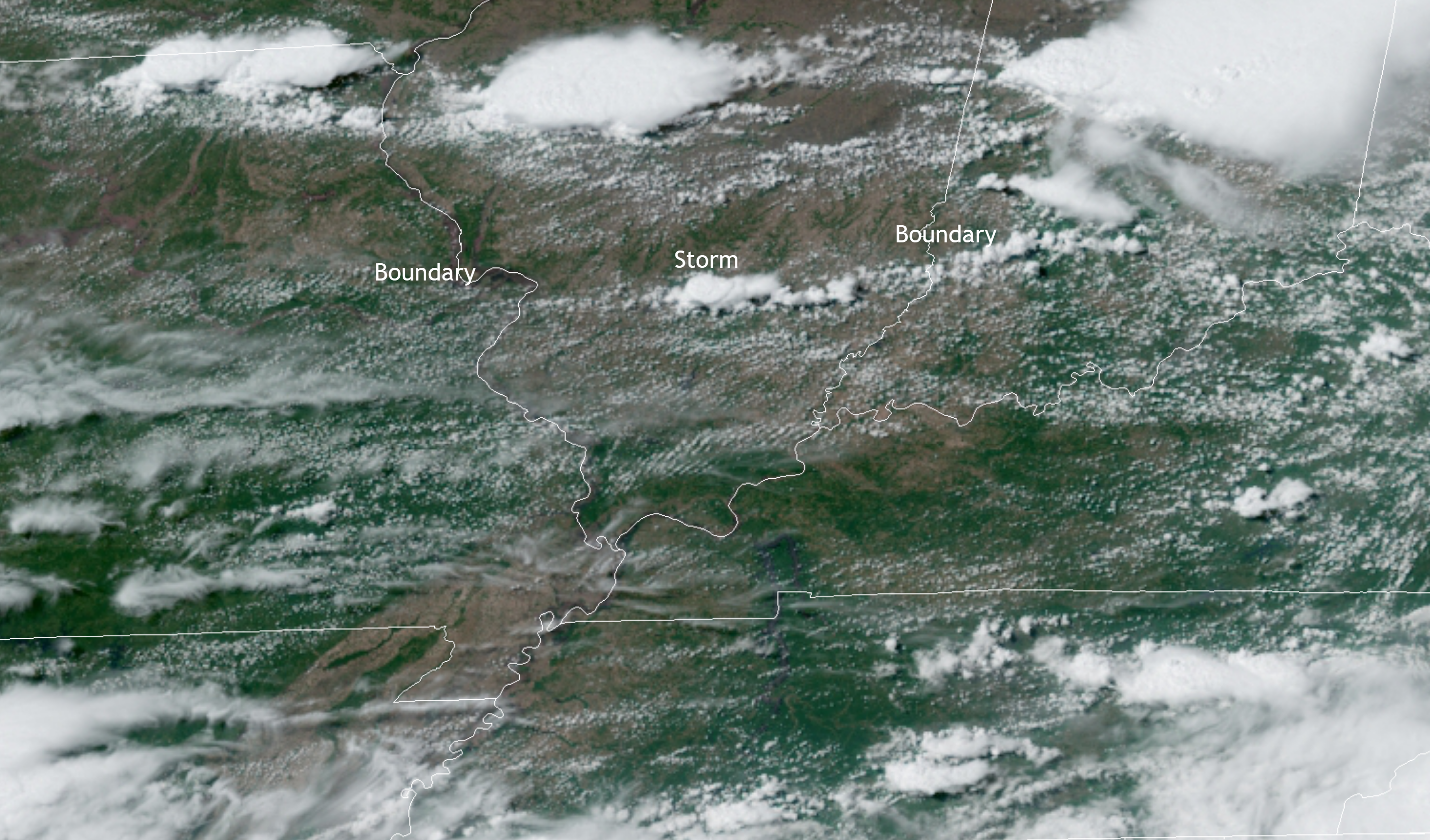
Satellite
Cumulus clouds bubbling up. Thunderstorms. One north of Mt Vernon, IL. It already has a severe thunderstorm warning on it.
.
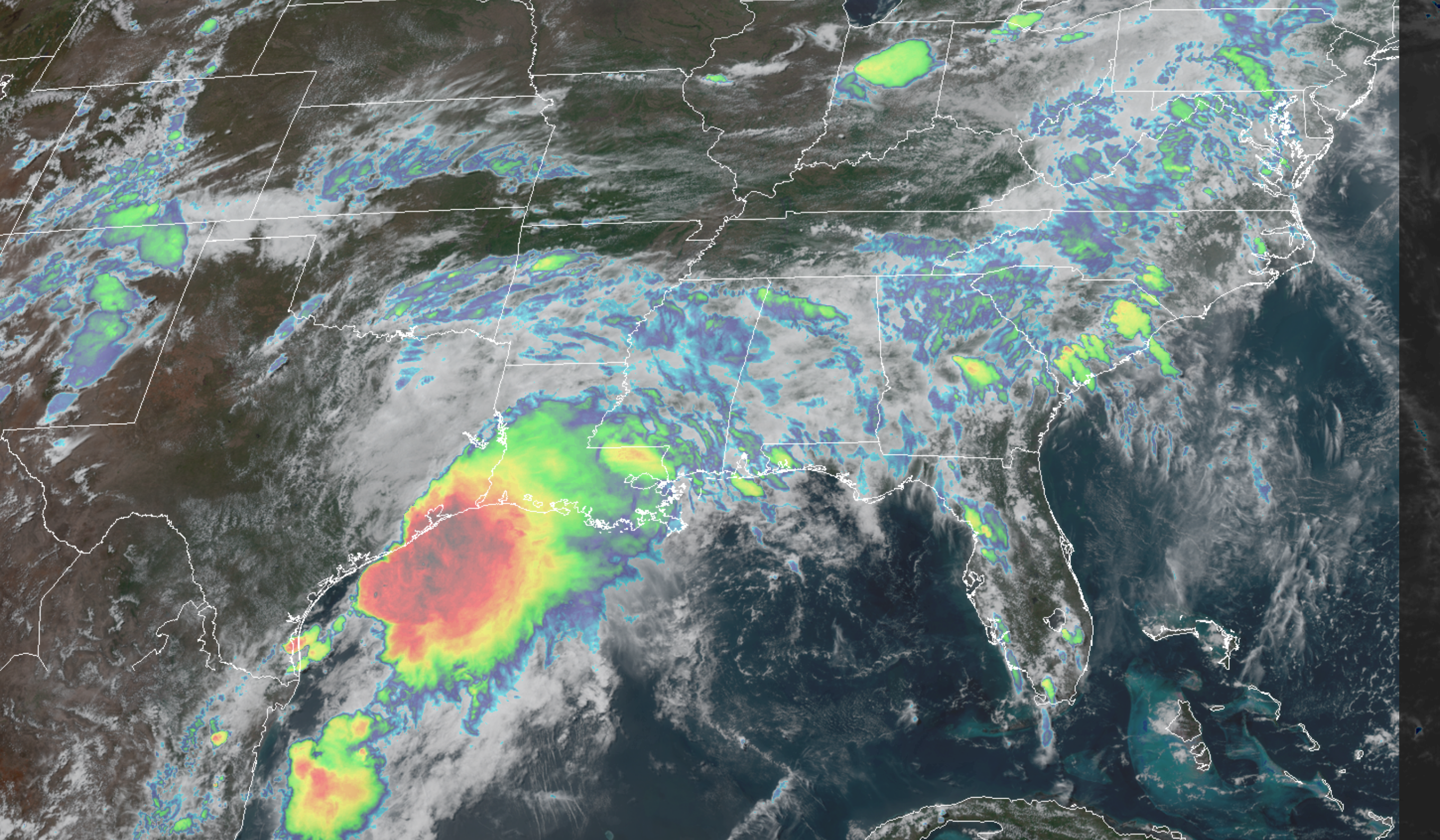
Gulf of Mexico tropical feature
That blog of moisture will increase our PWAT numbers over the coming days. Tremendous amount of moisture in the atmosphere. That spells locally heavy rain.
Slow moving storms can produce one to three inches per hour.
.
.
.
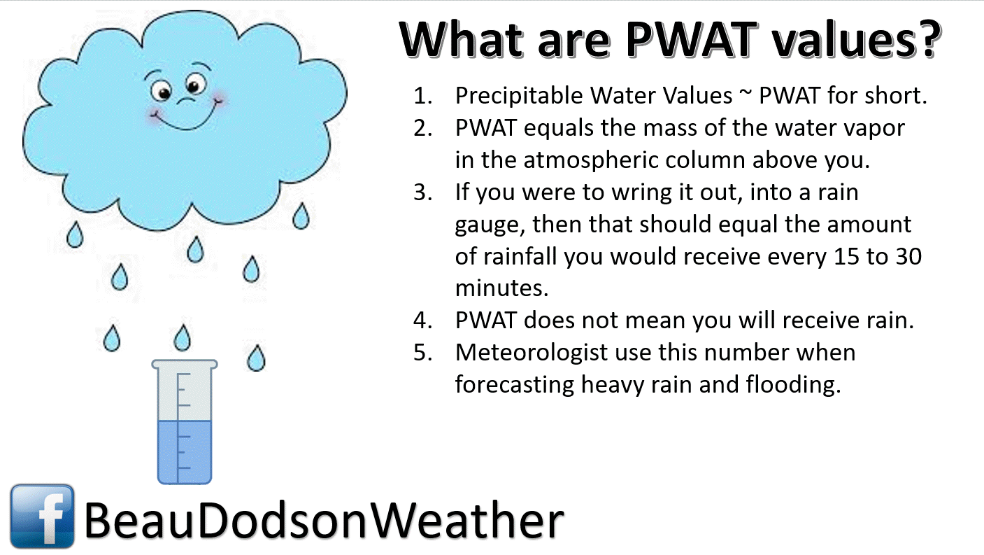
Tonight’s PWAT values will be extreme for this time of the year. Top of the chart.
That will make shower and thunderstorms prolific rain producers. Tropical-like.

.
.
3:10 PM
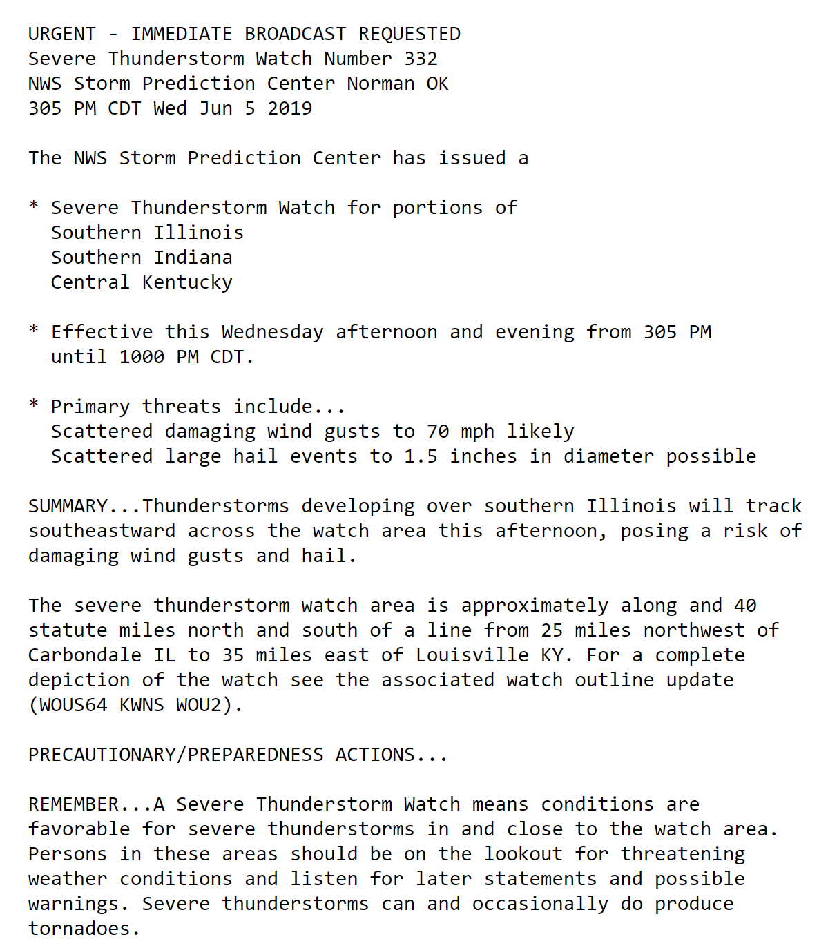
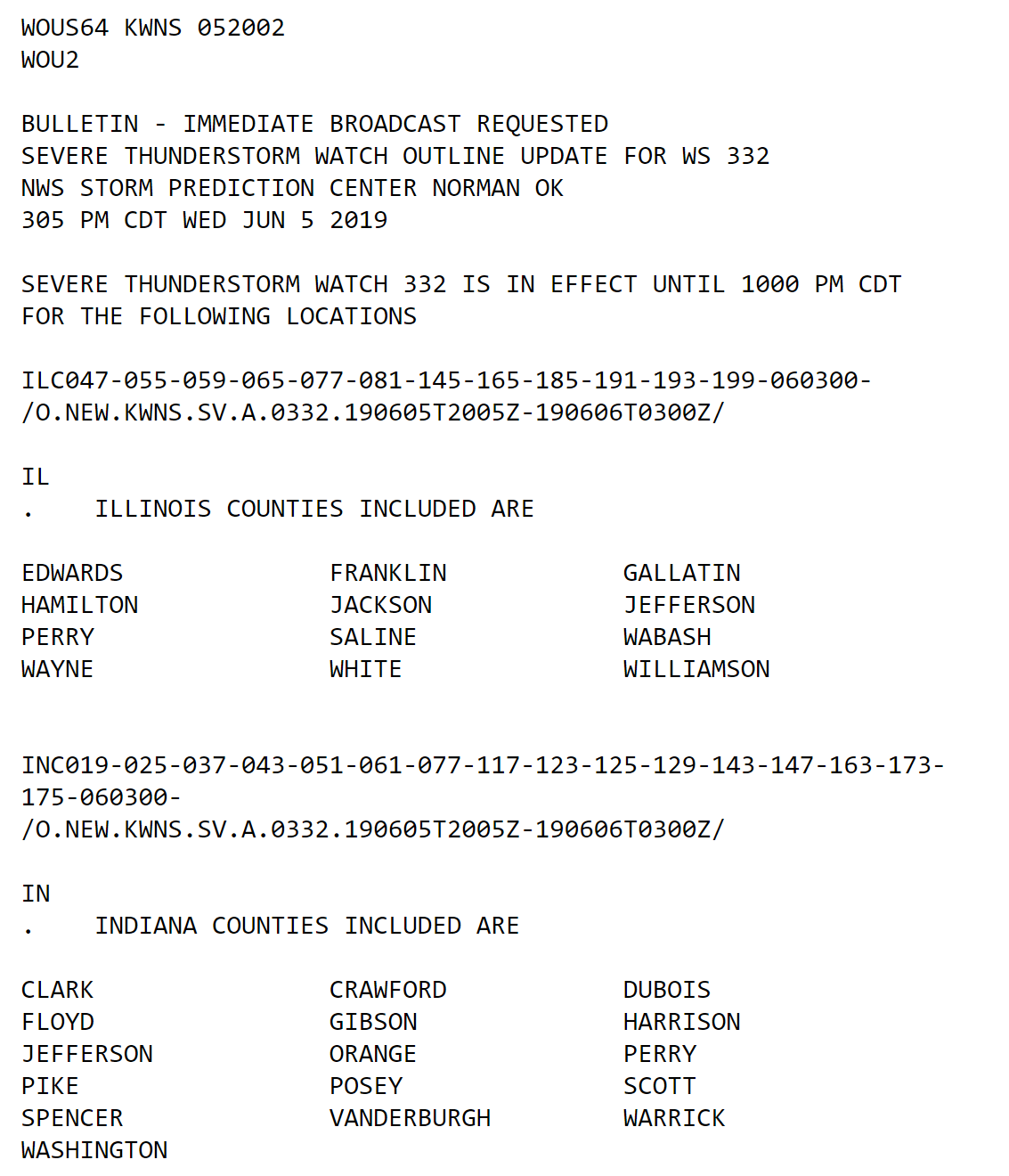
The Storm Prediction Center may issue a severe thunderstorm watch for parts of the area.
Here is their new discussion.
SPC discussion

.
.
2:55 PM
Good evening, everyone.
We have a risk of severe weather into tonight.
The main concern will be the northern half of southeast Missouri, much of southern Illinois, and northwest Kentucky.
A few storms could produce large hail, damaging wind gusts, frequent cloud to ground lightning, and torrential rain. The tornado risk is low, but it is not a zero risk.
A line of storms is forming across portions of northeastern Missouri into central Illinois, and Indiana.
This line of storms will sag southward as we move through the coming hours and into tonight.
Scattered thunderstorms may last well into the night. There will be some weakening as we push deeper into the overnight hours.
As the thunderstorms move below severe levels, there will still be a risk of heavy rain.
Thunderstorms, in this extremely moist atmosphere, could produce one to three inches per hour. This could cause flash flooding.
Your storm tracking tools can be found above and then scroll down for additional links.
I will post updates, as necessary.
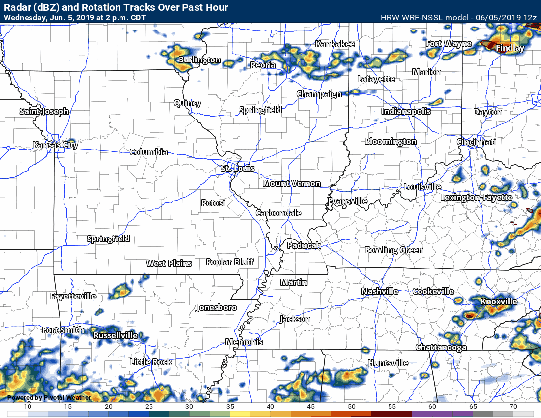
Here is the Hrrr model guidance future-cast radar. What it believes radar will look like over the coming hours.
Keep in mind, this is a model. Models are not perfect.
Notice the bulk of the storms are located across our northern counties.

.
Here is the SPC WRF model guidance. Another model.
Notice how the line peaks across our northern counties.
.
Not receiving app/text messages?
Make sure you have the correct app/text options turned on. Find those under the personal notification settings tab at www.weathertalk.com. Red is off. Green is on.
Subscribers, PLEASE USE THE APP. ATT and Verizon are not reliable during severe weather. They are delaying text messages.
The app is under Beau Dodson Weather in the app store.

Apple users click here

Android users click here
.

.

.
* The Missouri Bootheel includes Dunklin, New Madrid, and Pemiscot Counties
* Northwest Kentucky includes Daviess, Henderson, McLean Union, and Webster Counties
County Maps: Click Here
.
.
Today’s outlook (below).
Light green is where thunderstorms may occur but should be below severe levels.
Dark green is a level one risk. Yellow is a level two risk. Orange is a level three (enhanced) risk. Red is a level four (moderate) risk. Pink is a level five (high) risk.
One is the lowest risk. Five is the highest risk.
Light green is not assigned a number. Light green is where storms may occur but should be below severe levels.
A severe storm is one that produces 60 mph winds or higher, quarter size hail, and/or a tornado. One or more of those is defined as a severe thunderstorm.

The black outline is our local area.

.
Tomorrow’s outlook.
Light green is where thunderstorms may occur but should be below severe levels.
Dark green is a level one risk. Yellow is a level two risk. Orange is a level three (enhanced) risk. Red is a level four (moderate) risk. Pink is a level five (high) risk.
One is the lowest risk. Five is the highest risk. Light green is not assigned a number.


.
.
Here is the latest graphic from the WPC/NOAA.
24-hour precipitation outlook.
.

.
48-hour precipitation outlook.
.
.
.
72-hour precipitation outlook.
.

.
Days one through seven added together. Seven-day rainfall totals.

.

Radar Link: Interactive local city-view radars & regional radars.
You will find clickable warning and advisory buttons on the local city-view radars.
If the radar is not updating then try another one. If a radar does not appear to be refreshing then hit Ctrl F5. You may also try restarting your browser.
Not working? Email me at beaudodson@usawx.com
National map of weather watches and warnings. Click here.
Storm Prediction Center. Click here.
Weather Prediction Center. Click here.
.

Live lightning data: Click here.
.

Interactive GOES R satellite. Track clouds. Click here.
GOES 16 slider tool. Click here.
College of Dupage satellites. Click here
.

Here are the latest local river stage forecast numbers Click Here.
Here are the latest lake stage forecast numbers for Kentucky Lake and Lake Barkley Click Here.
.
Did you know that you can find me on Twitter? Click here to view my Twitter weather account.

.

.
Who do you trust for your weather information and who holds them accountable?
I have studied the weather in our region since the late 1970s. I have 40 years of experience in observing our regions weather patterns.
My degree is in Broadcast Meteorology from Mississippi State University and a Bachelor of Science (BS).
I am an NOAA Weather-Ready Nation Ambassador. I am the Meteorologist for McCracken County rescue squad. When asked, I assist Ballard and Massac Counties, as well.
I own and operate the Southern Illinois Weather Observatory and WeatherTalk LLC.
There is a lot of noise on the internet. Over time you should learn who to trust for your weather information.
My forecast philosophy is simple and straight forward.
- Communicate in simple terms
- To be as accurate as possible within a reasonable time frame before an event
- Interact with you on Twitter, Facebook, and the blog
- Minimize the “hype” that you might see on television or through other weather sources
- Push you towards utilizing wall-to-wall LOCAL TV coverage during severe weather events
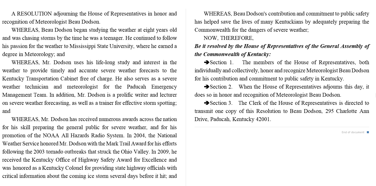
I am a recipient of the Mark Trail Award, WPSD Six Who Make A Difference Award, Kentucky Colonel, and the Caesar J. Fiamma” Award from the American Red Cross.
In 2009 I was presented with the Kentucky Office of Highway Safety Award.
I was recognized by the Kentucky House of Representatives for my service to the State of Kentucky leading up to several winter storms and severe weather outbreaks.
If you click on the image below you can read the Kentucky House of Representatives Resolution.
.
.
Previous episodes can be viewed by clicking here.
.
Find Beau on Facebook! Click the banner.

.
Find Beau on Twitter! Share your weather photos! @beaudodson

.
Did you know that a portion of your monthly subscription helps support local charity projects? Not a subscriber? Becoming one at www.weathertalk.com
You can learn more about those projects by visiting the Shadow Angel Foundation website and the Beau Dodson News website.
