June 21, 2019
BEGIN LIVE BLOG
.

Live lightning data: Click here.

Radar Link: Interactive local city-view radars & regional radars.
.
County Maps: Click Here
.
FACEBOOK Q&A LINK
CLICK HERE
.
Live-interactive radars: Click here
Regional radar link: Click here
.
Live lightning data: Click here.
.
Additional storm tracking tools can be found at the bottom of the page.
.
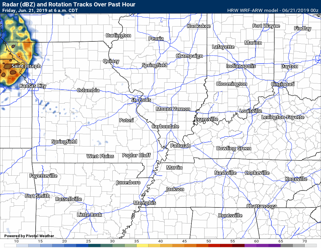
6;15 AM
Storms this morning are producing heavy rain, gusty winds, and lightning.
Radar Link: Interactive local city-view radars & regional radars.
.
9 PM
Friday night/Saturday morning Facebook Q&A
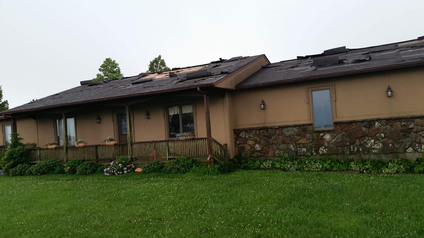
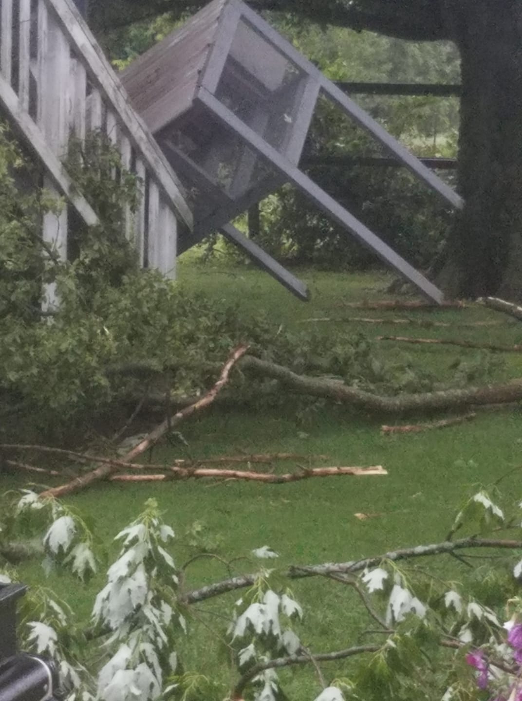
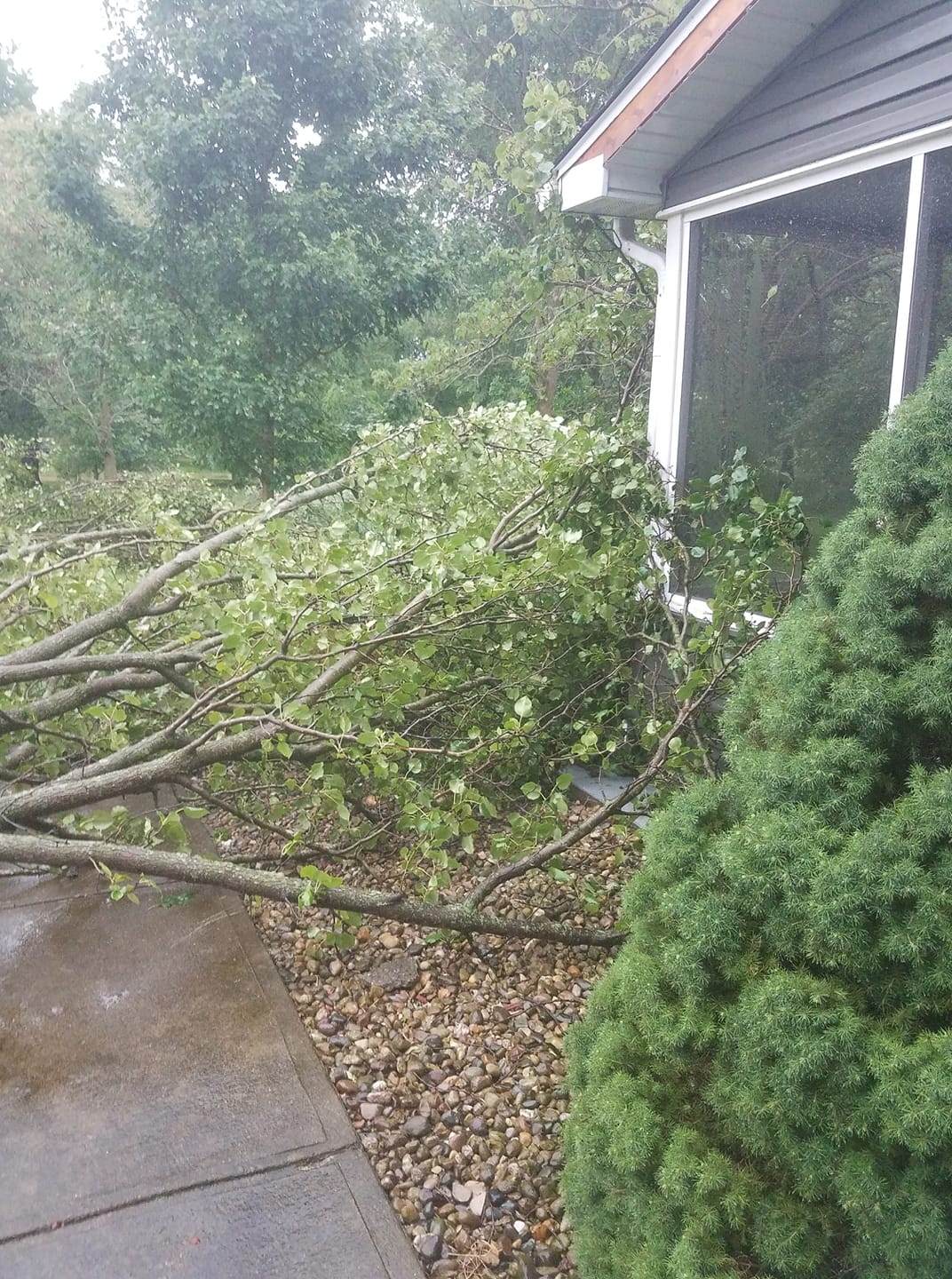
Some damage photos
Dustin Bryant photographer.
NW of Chaffee, Missouri.
North of Herrin, IL on Freeman Spur Blacktop. Lesley Restivo photographer.

—-
Magan McGrew took this photograph.
Paducah, KY.

7:30 PM
Severe threat has ended for the region, for now.
I am monitoring a possible thunderstorm complex late tonight into early Saturday morning.
At this time, the severe risk appears small, but not zero.
I will keep an eye on it. I will keep the live blog active.
.
7:28 PM
Severe threat has ended for Todd County.
7:09 PM
Local Storm Report by NWS PAH: 2 S Ullin, IL [Pulaski Co, IL] broadcast media reports thunderstorm wind damage at 04:45 PM CDT — *** 1 fatal *** one person was killed when a tree fell onto a car on Old Highway 51.
7:08 PM
We had a tornado alert on this storm well in advance.
Here is one storm report.
Local Storm Report by NWS PAH: 6 NE Herndon [Christian Co, KY] emergency manager reports thunderstorm wind damage at 06:42 PM CDT — significant damage to a house on locus grove road. time estimated.
7:07 PM
Todd County. There is still some potential of a tornado in southern Todd County. Stay sheltered. Rotation is weaker.
6:50 PM
Christian and Todd. A report of a possible tornado seen on a tower cam south of Hopkinsville. Stay sheltered as this storm moves east at 35 mph.
6:46 PM
Christian and Todd. Storm with a possible tornado near or south of Hopkinsville continues to move east at 35 mph. Stay sheltered if you are in the path of this storm.
.
6:38 PM
Christian County. Tornado likely. Seek shelter. Tracking a poss tornado west of Casky, KY. Another NW of Herndon, KY. Moving east.
.
6:33 PM
Teresa Vance took this photograph of a large hail stone near Barlow, KY earlier tonight.

.
6:33 PM
Radar shows a possible tornado northwest of Herndon, KY in Christian County. Seek shelter. Moving east.
.
6:18 PM
Hopkins, Trigg, Christian, Todd, and Muhlenberg. Storms continue to track through your area and into your area. Seek shelter as there have been numerous reports of 70 to 75+ mph winds with these storms today.
.
6:13 PM
Trigg. Rotation west of Cadiz. Let’s be alert and prepared to seek shelter. Storms are moving east.
.
6:00 PM
Calloway, Weakley, Henry. Radar shows widespread 60 to 75 mph winds moving into and through your area. Seek shelter until this storm passes.
.
5:56 PM
Some of the storms are producing golf ball size hail, as well. I have been focussing on the wind but hail is possible.
.
5:54 PM
Marshall and Calloway Storms are moving in and through. Winds of 70 mph are possible. Locally higher. This will cause damage. Seek shelter as storms approach.
.
5:44 PM
Trigg, Christian, Muhlenberg, and Todd. Be aware storms approaching from the W NW have a long history of wind damage. If they hold together they will also impact your counties.
.
5:41 PM
Numerous reports of damage in the region. Storms have produced widespread tree damage.
Structural damage in some areas.
These storms mean business.
.
5:32 PM
McLean County. Intense storms continue. Winds above 70 mph are possible in some locations. Be aware.
.
5:30 PM
Graves. Radar shows multiple pockets of 70+ MPH wind moving into and through the county. Be prepared for wind damage in some locations.
.
5:28 PM
Large tree down on 28th between Jefferson and the Family Dollar store in Paducah.
Semi over on I24.
.
5:20 PM
Radar shows a possible tornado near Brookport. Near the Ohio River. Seek shelter. Movement east.
.
5:19 PM
Massac, Pope, McCracken, Livingston Be aware these storms could also produce short lived tornadoes. Be prepared to seek shelter.
.
5:15 PM
Daviess County. A powerful storm is moving through your county. 70+ mph winds possible. Hail and flash flooding. Seek shelter until this storm passes. Large storm.
.
5:14 PM
I am receiving numerous reports of wind damage with these thunderstorms. Seek shelter until the storms pass.
Winds of 70+ mph are possible with the most intense storms.
.
5:13 PM
Saline, Gallatin, Pope, & Hardin. Remain alert as new storms move through your area. Damaging winds are possible.
.
5:11 PM
Marshall, Calloway, Henry. Storms are approaching from the west with a history of wind damage. Be prepared to seek shelter if they maintain strength.
.
5:09 PM
These storms mean business. Damage is likely in some areas with winds above 70 mph.
Carlisle County. Storm in the western part of county moving E SE has some rotation. Seek shelter until the storm passes.
.
5:00 PM
Dunklin, Pemiscot, Lake, and Obion. Storms approaching from the NW will produce pockets of wind damage, hail, and very heavy rain. Be weather aware over the coming hour.
.
5:00 PM
Williamson, Johnson, Saline, Pope. Be aware sometimes storms of this size can produce short-lived tornadoes. Be weather aware.
.
4:56 PM
Union, Johnson, Williamson, Saline, Pope be aware some of these storms are producing 70 mph wind gusts.
Dangerous storms.
.
4:55 PM
Lyon, Caldwell, Hopkins, McLean. Storms approaching from the west could produce 65 mph winds. Torrential rain and hail, as well. Lightning. Be aware.
.
4:45 PM
Hickman, Fulton, and Graves. Storms approaching from the northwest are producing damaging wind. Let’s be aware over the coming hour+.
Ballard, McCracken, Carlisle. Storms are approaching from the west/northwest. Some of these storms could produce pockets of damaging wind, torrential rain, lightning, and small hail. Be aware.
Live radars http://weatherobservatory.com/weather-radar.htm

.
4:44 PM
Massac County. Storms are approaching from the west/northwest. Some of these storms could produce pockets of damaging wind, torrential rain, lightning, and small hail. Be aware.
Live radars http://weatherobservatory.com/weather-radar.htm
.
4:42 PM
Northern Dunklin, New Madrid, Mississippi Storms approaching from the W NW could produce pockets of wind damage. Torrential rain, lightning, and small hail, as well.
.
4:37 PM
Power outages in Butler, Bollinger, Perry, and Cape Girardeau Counties in southeast Missouri.
Local Storm Report by NWS PAH: 1 WSW Cape Girardeau [Cape Girardeau Co, MO] public reports TSTM WND DMG at 04:25 PM CDT — 60 mph wind gust. Broken tree limbs and roof shingle damage.
4:37 PM
Far northern Livingston County. Intense storms could produce isolated wind damage. Additional storms will impact more of the county later this evening. Be aware.
.
4:28 PM
Daviess and Webster. Heavy storms approaching from the west. Some could produce isolated damaging wind gusts. Flash flooding, as well. Lightning and small hail.
Alexander and Pulaski. Storms approaching from the W NW could produce pockets of damaging wind gusts, lightning, torrential rain, and small hail.
.
4:26 PM
Flash Flood Warning for Jackson County [IL] till 10:15 PM CDT
.
4:21 PM
Southern Perry County, IL. Jackson County, IL. A large storm is moving into Jackson County. This storm could produce 70 mph wind gusts, nickel size hail, and flash flooding. Moving east/northeast at 50. Seek shelter.
.
4:18 PM
Perryville, MO. Tree and power line damage.
.
4:09 PM
Flash flood update. Some flooding possible.

.
4:05 PM
Butler, Stoddard, and Scott. Storms approaching from the NW will likely produce pockets of 55+ MPH wind gusts. Torrential rain/lightning. Isolated small hail, as well.
Live radars http://weatherobservatory.com/weather-radar.htm
.
4:00 PM
Union and Henderson Counties, KY. Storms over the coming one to two hours could produce isolated damaging wind. Be aware. Lightning/torrential rain. Small hail.
Live radars http://weatherobservatory.com/weather-radar.htm
.
3:56 PM
Pope and Hardin. Storms developing in your counties could produce isolated damaging wind gusts. Be aware.
Live radar http://weatherobservatory.com/radar_cape.htm
.
3:41 PM
Bollinger and Cape G Storms are approaching. Some could produce damaging wind gusts. Be aware.
This storm in southeast Missouri is a beast.
Dangerous storm.
Live radar
http://weatherobservatory.com/radar_cape.htm
.
3:38 PM
We have received reports of high wind in Hamilton County. Gusts around 60 mph.
Any of the storms today could produce high wind gusts.
There are going to be numerous warnings this afternoon. Most of those warnings will be for damaging wind gusts.
Isolated tornadoes are possible. A few reports of hail, as well.
Torrential rain. There is a lot of moisture in the atmosphere.
Lightning is a concern for outdoor activities.
.
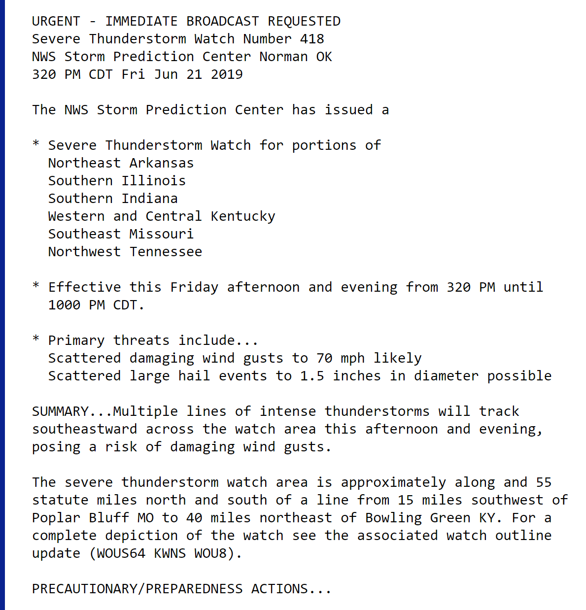
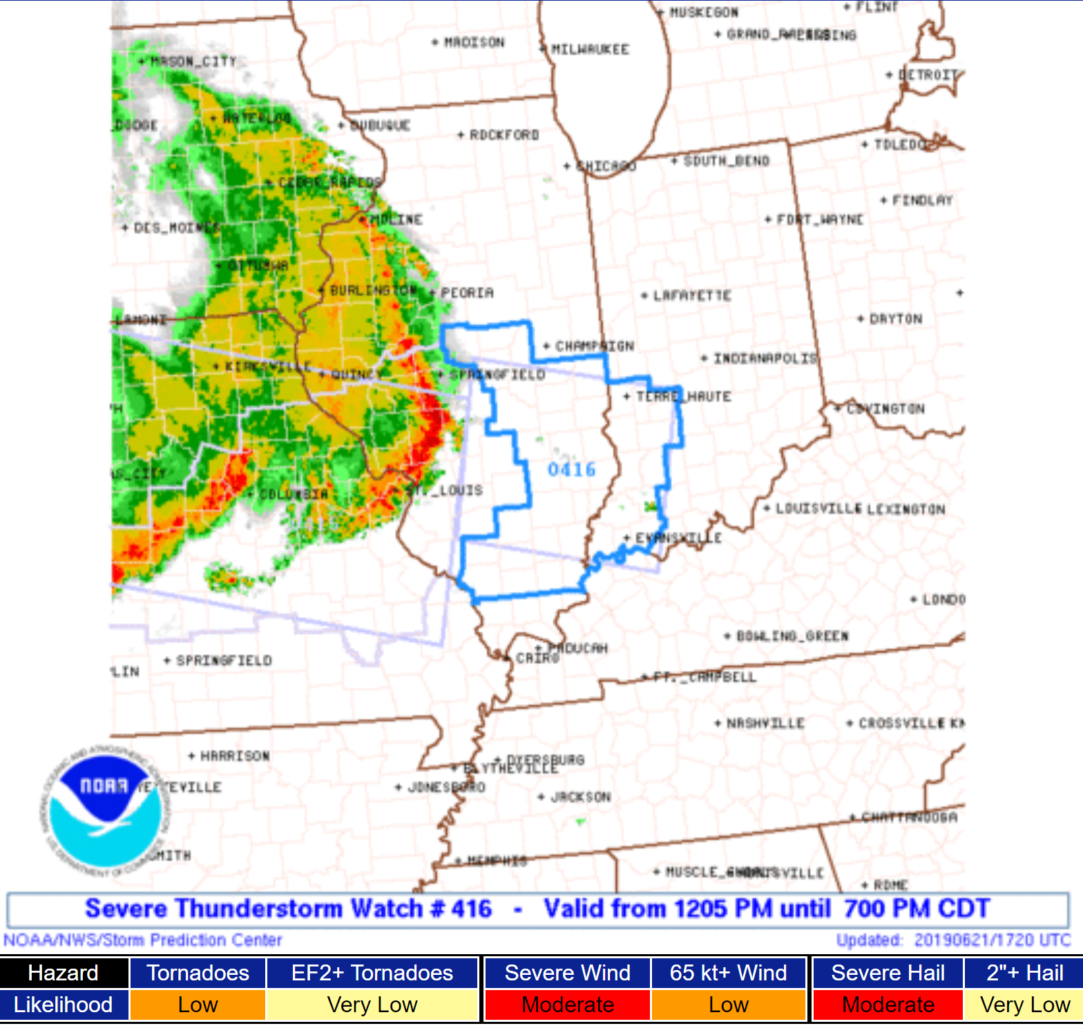
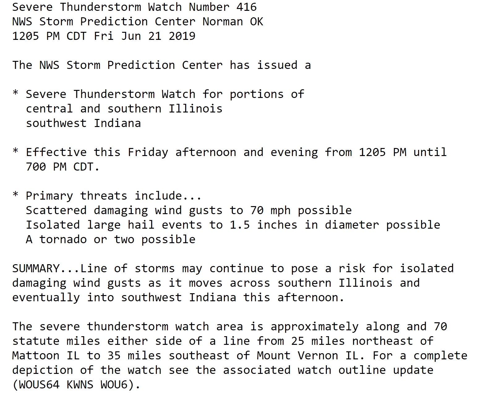
3;24 PM
Here is the newest severe thunderstorm watch.

.
3:17 PM
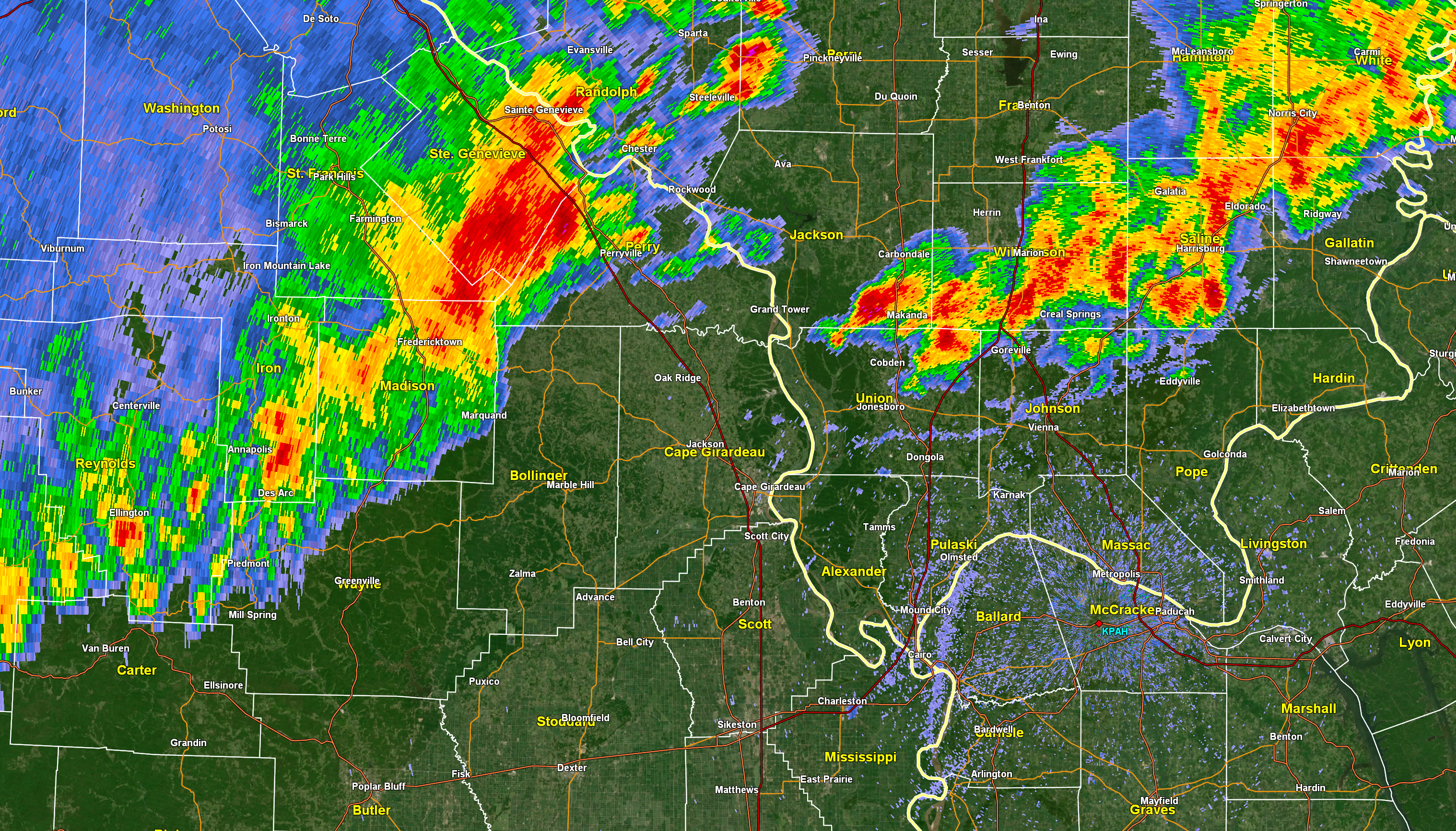
St. Genevieve & Perry, MO, Randolph, IL. Storms moving into and through your county over the coming hour could produce damaging wind. Small hail, as well. Be aware.
.
3:15 PM
Union and Johnson. Storms are moving into and through your counties. Damaging wind is a concern with the most intense storms. Be aware as storms approach.
.
3:00 PM
Jackson, Williamson, Saline, and Gallatin. Storms moving into and through your area could produce pockets of 55+ mph wind gusts. Be aware over the coming hours. Small hail.
.
2:53 PM
The Storm Prediction Center has updated their severe weather outlook.
They are likely going to issue a new watch.
Here are their latest thoughts.
Damaging wind remains the main concern.
.
2:21 PM
Randolph, Perry, Jefferson, Franklin, Hamilton, White. Line of storms moving through and into these counties. A few reports of 55+ MPH winds are possible. Small hail.
.
2:00 PM
.
12:47 PM
Satellite is impressive.
This is an MCS. A complex of thunderstorms. Two, actually.
.
12:35 PM
.

.
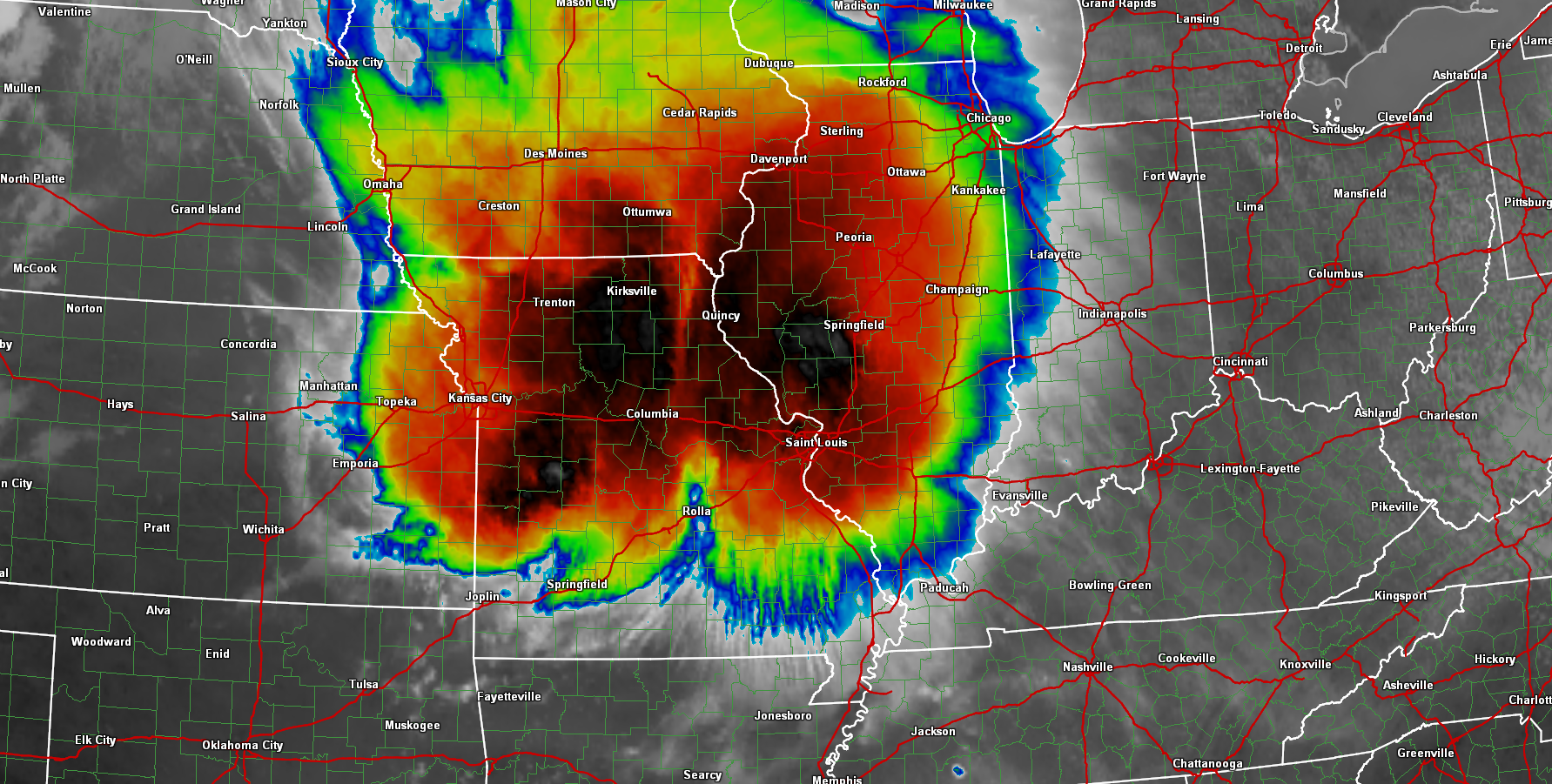
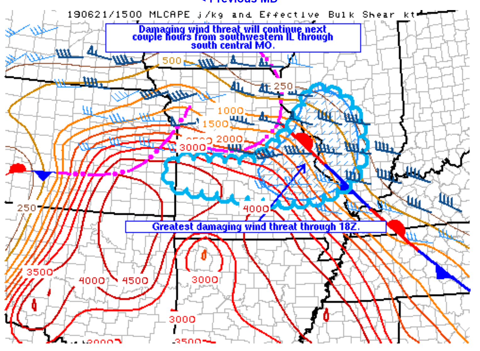
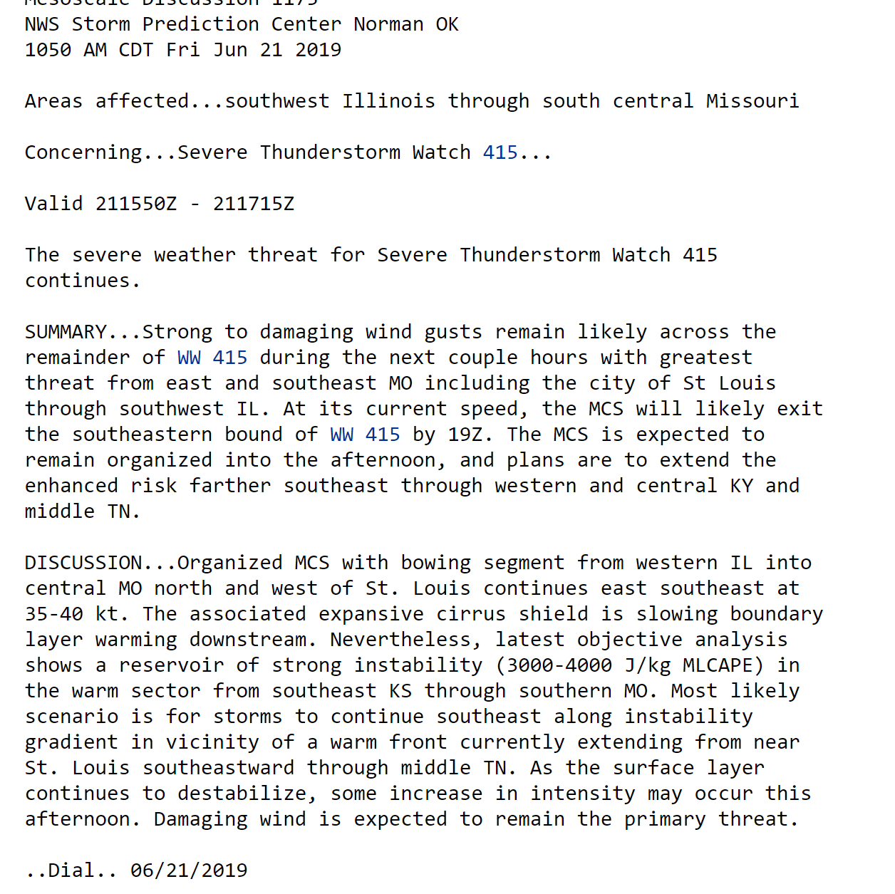
A line of intense thunderstorms continues to track east/southeast into our the local area.
There are currently two lines of thunderstorms.
One line has been producing damaging wind. That is the one near St Louis.
You can see the newest severe thunderstorm watch below. This is in addition to the other watch.
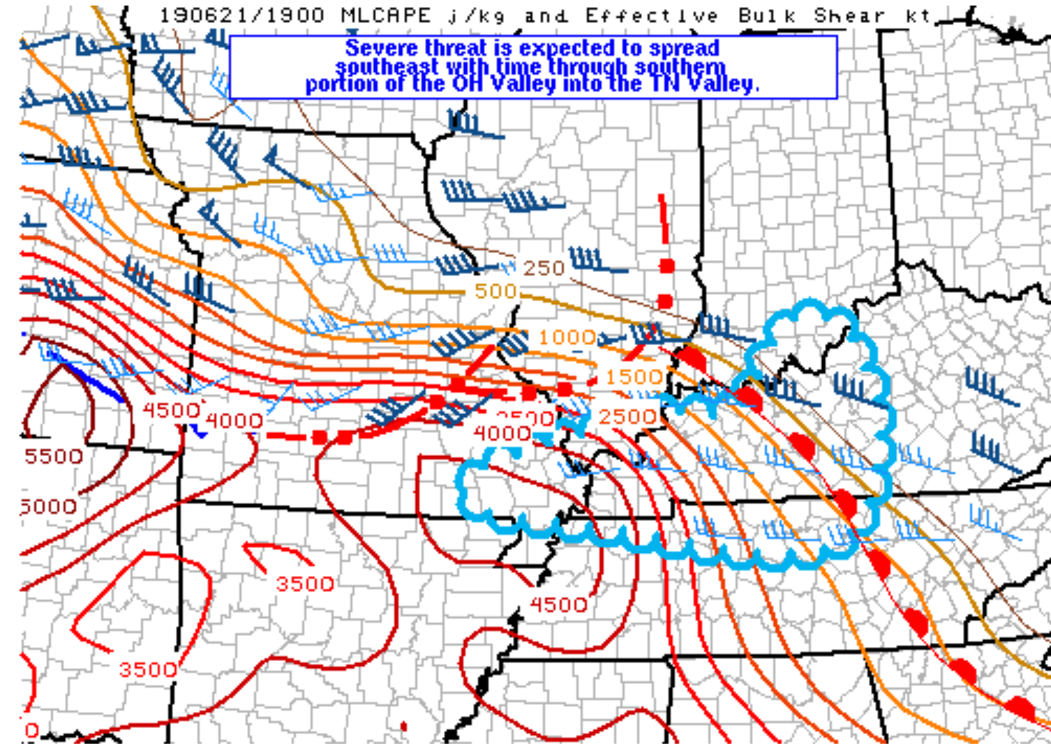
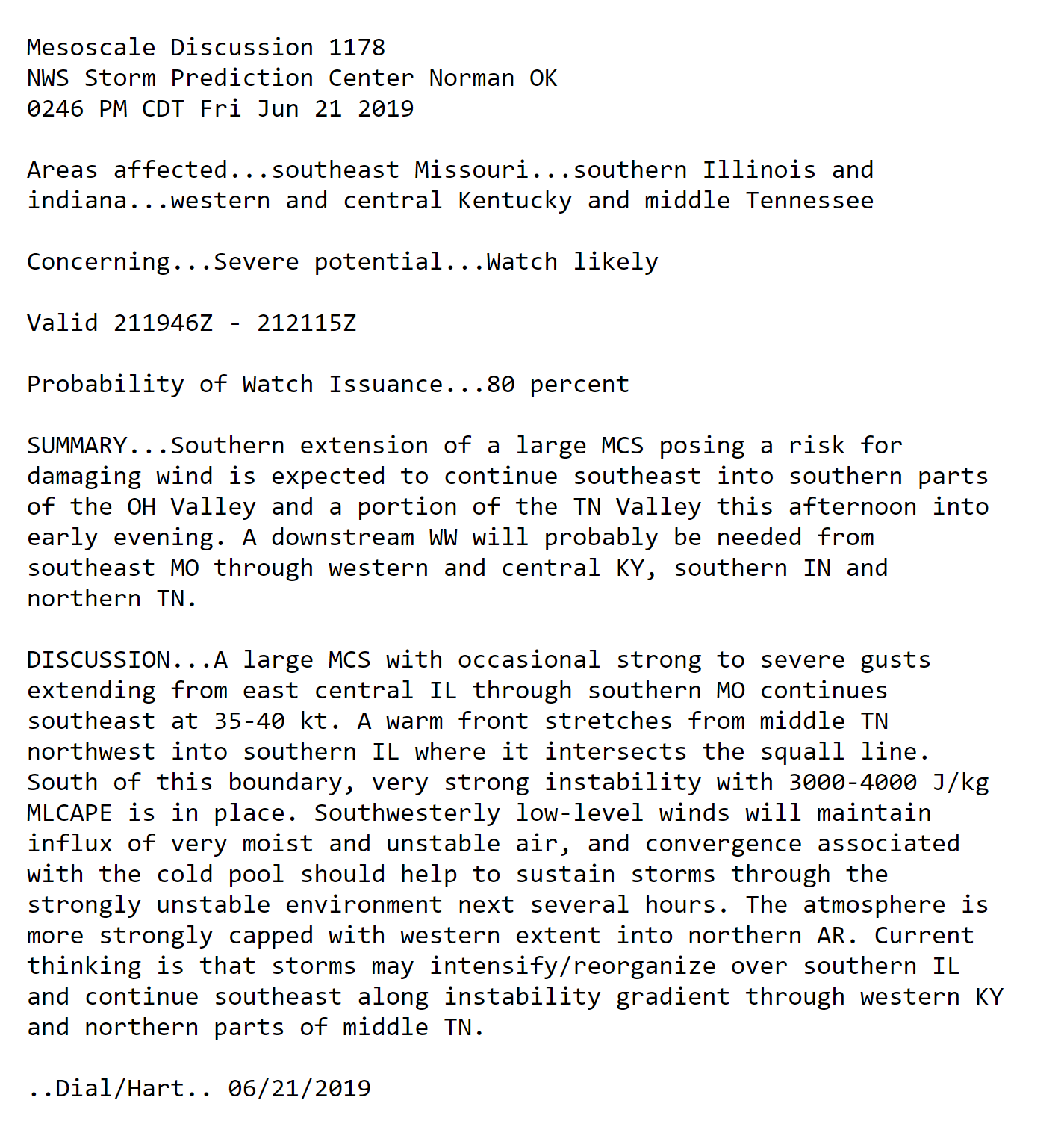
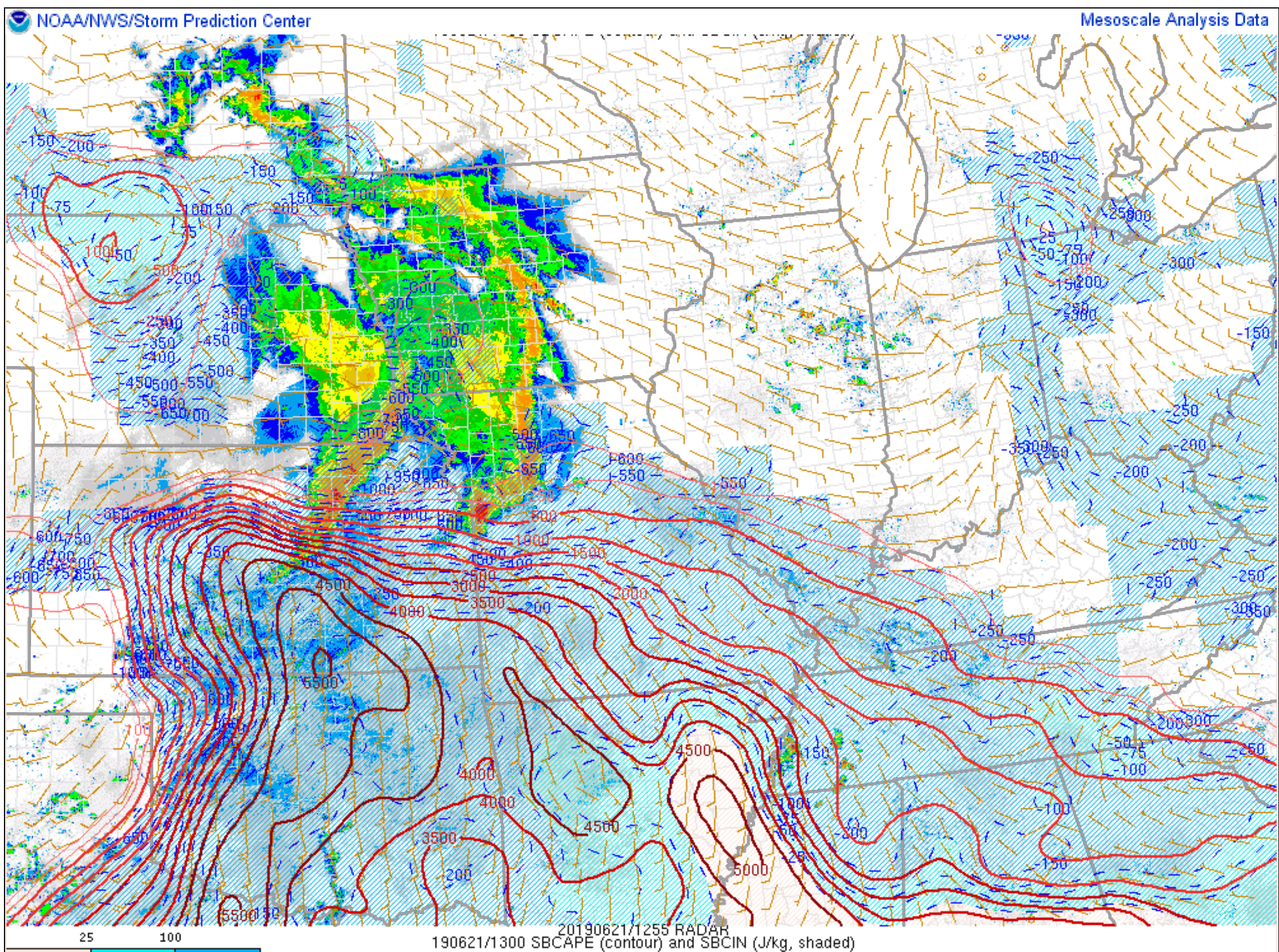
The second line of thunderstorms is across central Missouri to southwest Missouri. This line is moving southward into an extremely unstable air-mass. It too can produce damaging wind.
CAPE values of 3000 to 5000+ are being observed over southern Missouri.
Wind shear over southern Missouri is weak but we have the cool pool behind the storms that is helping to enhance its southward movement.
Thunderstorms will be with us into the afternoon and evening hours.
These storms will likely remain intense into this evening as they move into our local area. Additional watches and warnings are likely.
Monitor the latest updates.
CAPE values.
CAPE is energy that thunderstorms tap into. There are extreme numbers over portions of our region. The Storm Prediction Center Meso-analysis page is even showing 6000 readings. That is extreme.
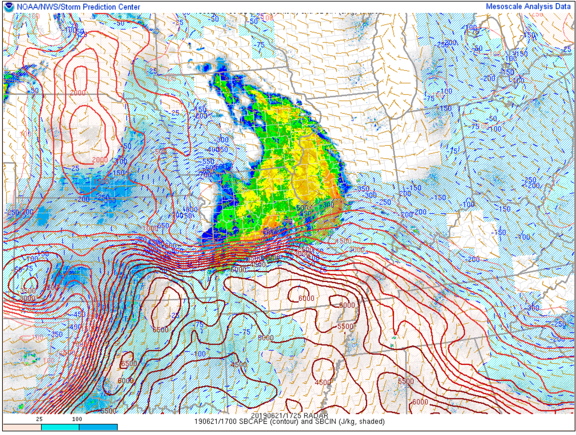
Lift index values indicate unstable air, as well.
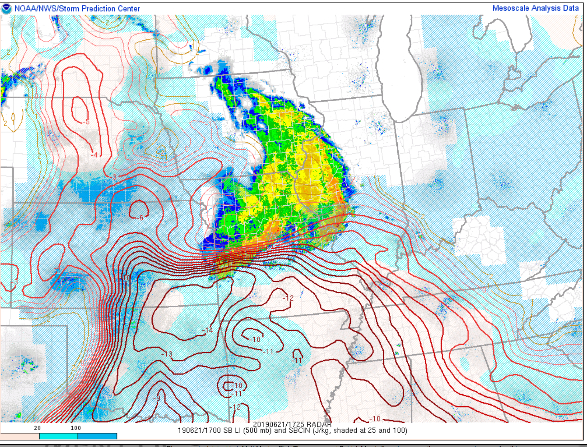
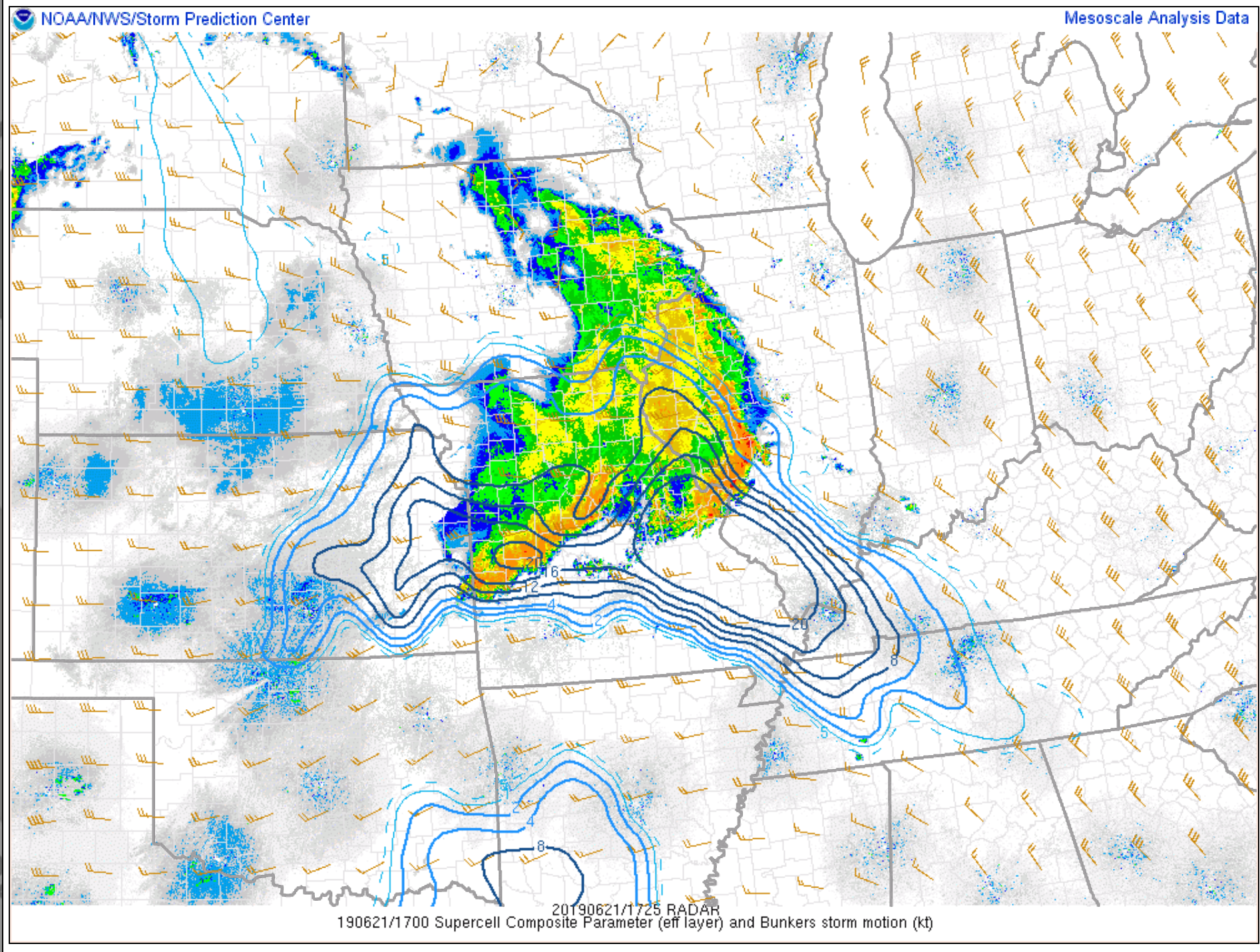
The SPC supercell composite is showing high numbers over portions of our local area.
One more indicator that we may have severe storms.
.
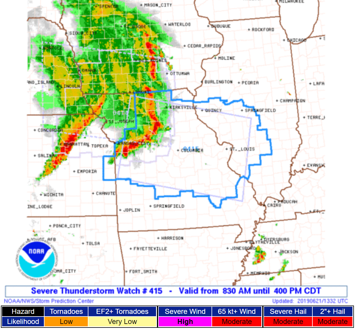
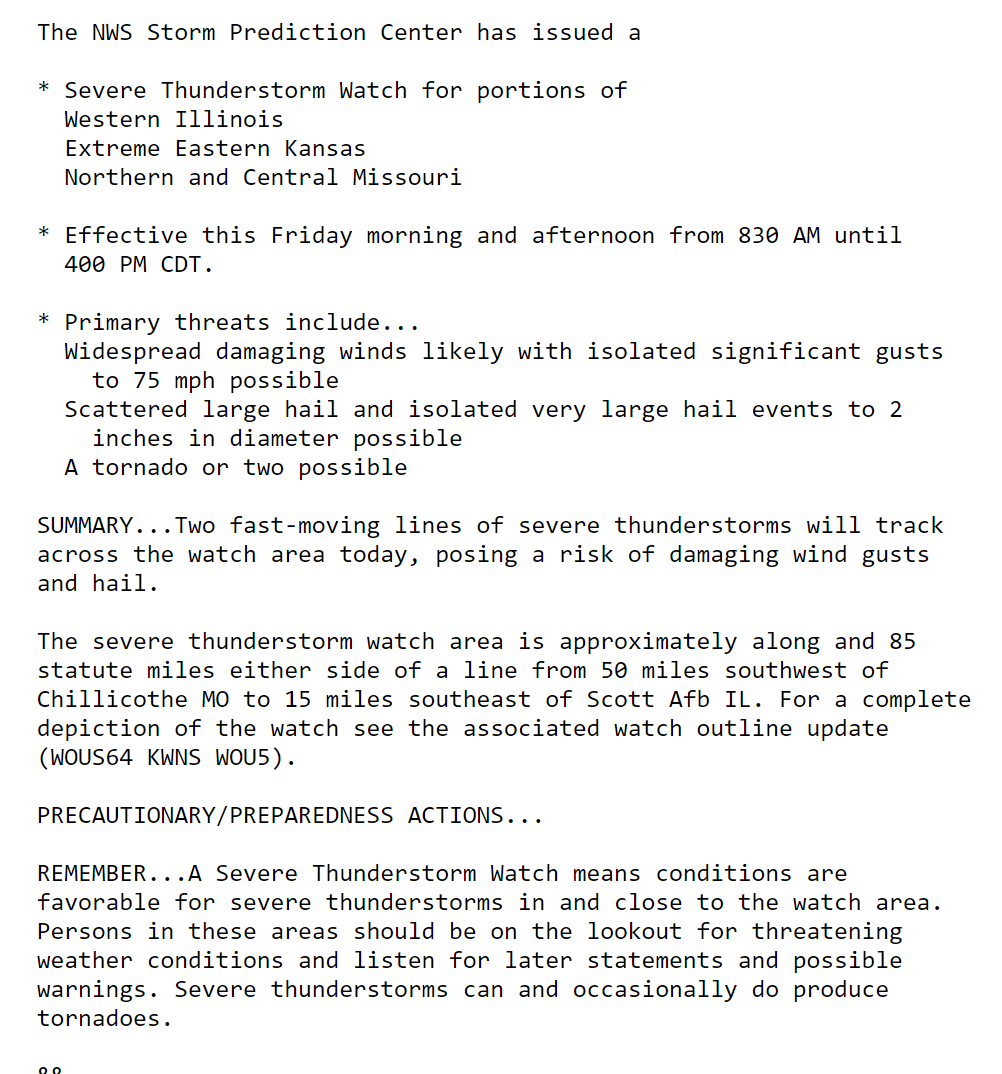
11:55 AM
Severe thunderstorm watch has been extended east.
.
Here is the older watch
.
11:50 AM
Severe Thunderstorm Watch for Edwards, Franklin, Gallatin, Hamilton, Jackson, Jefferson, Perry, Saline, Wabash, Wayne, White, Williamson [IL] and Gibson, Pike, Posey, Vanderburgh, Warrick [IN] till 7:00 PM CDT
Storm Prediction Center comments.
The line continues to move east/southeast.
The line remains intense but has weakened some.
We will have to see what happens over the next couple of hours.
Some severe thunderstorm warnings are certainly possible over portions of the region.

.
.
10:00 AM
I am going to analyze some data.
I will post again around 11 AM.
Please monitor updates moving forward. I am concerned about damaging wind along the leading edge of the squall line.
.
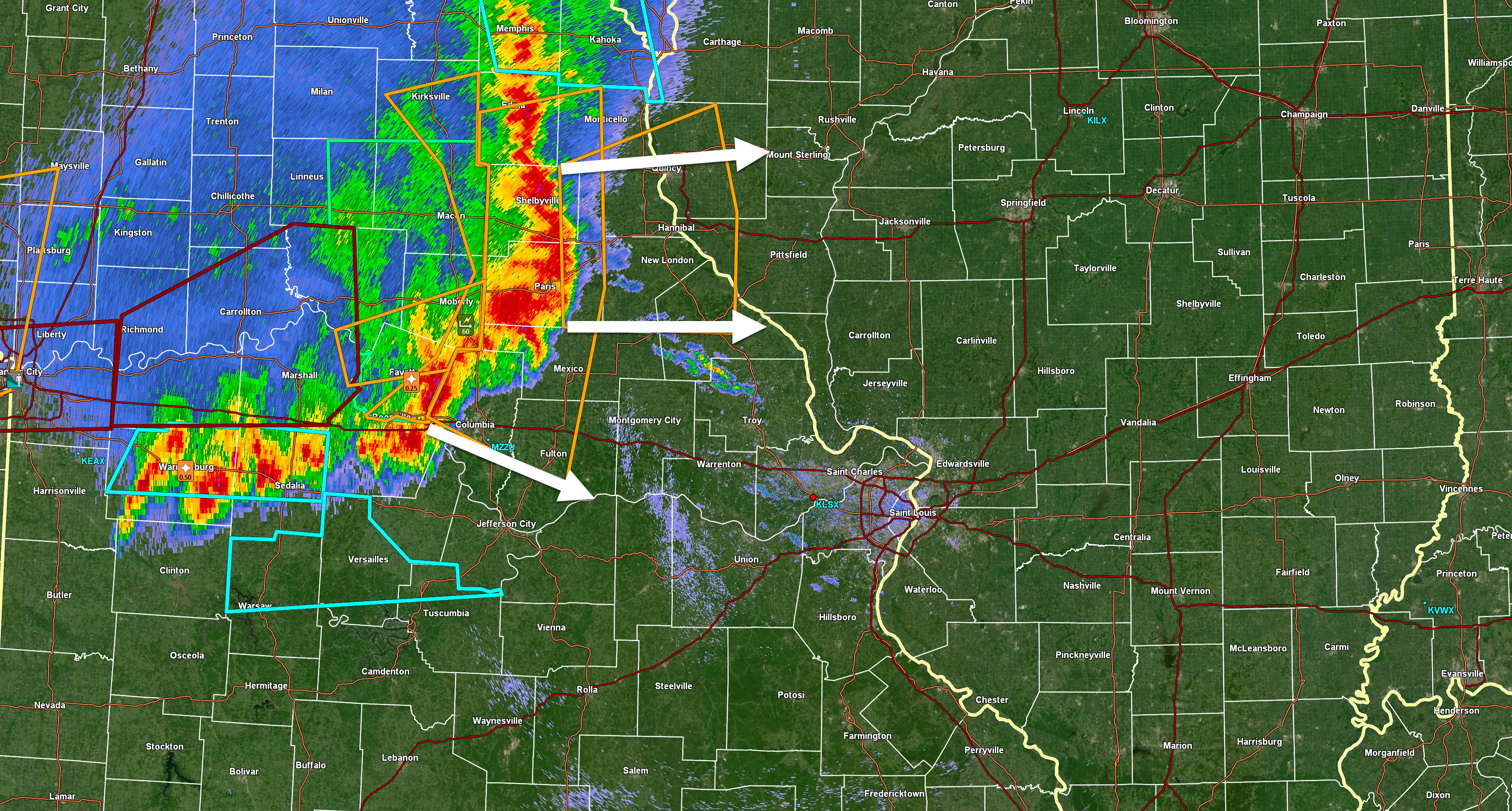
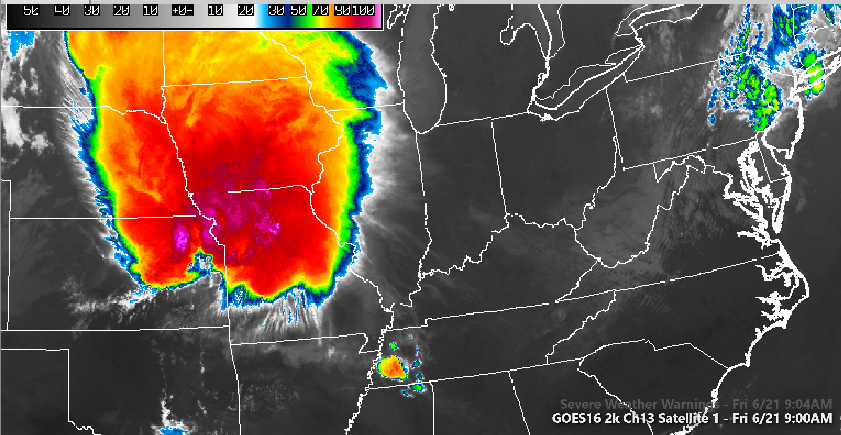
9:45 AM
Notice the last warning is pointed eastward vs southeast. We will need to monitor this.
Radar image. Orange boxes are severe thunderstorm warnings.
The blue box is a significant weather advisory (sub-severe).
.
9:30 AM
Storms continue to rapidly move southeast. They are moving at speeds of 55 mph.
If the bow turns east then the line will shift eastward, as well. Let’s monitor the next few hours.
There has been some slight turn to the east over the last 15 minutes.
Damaging wind is being reported with the bowing line of storms. When storms bow outward they tend to produce damaging wind gusts. Isolated tornadoes can also occur along the leading edge of the bow.
.
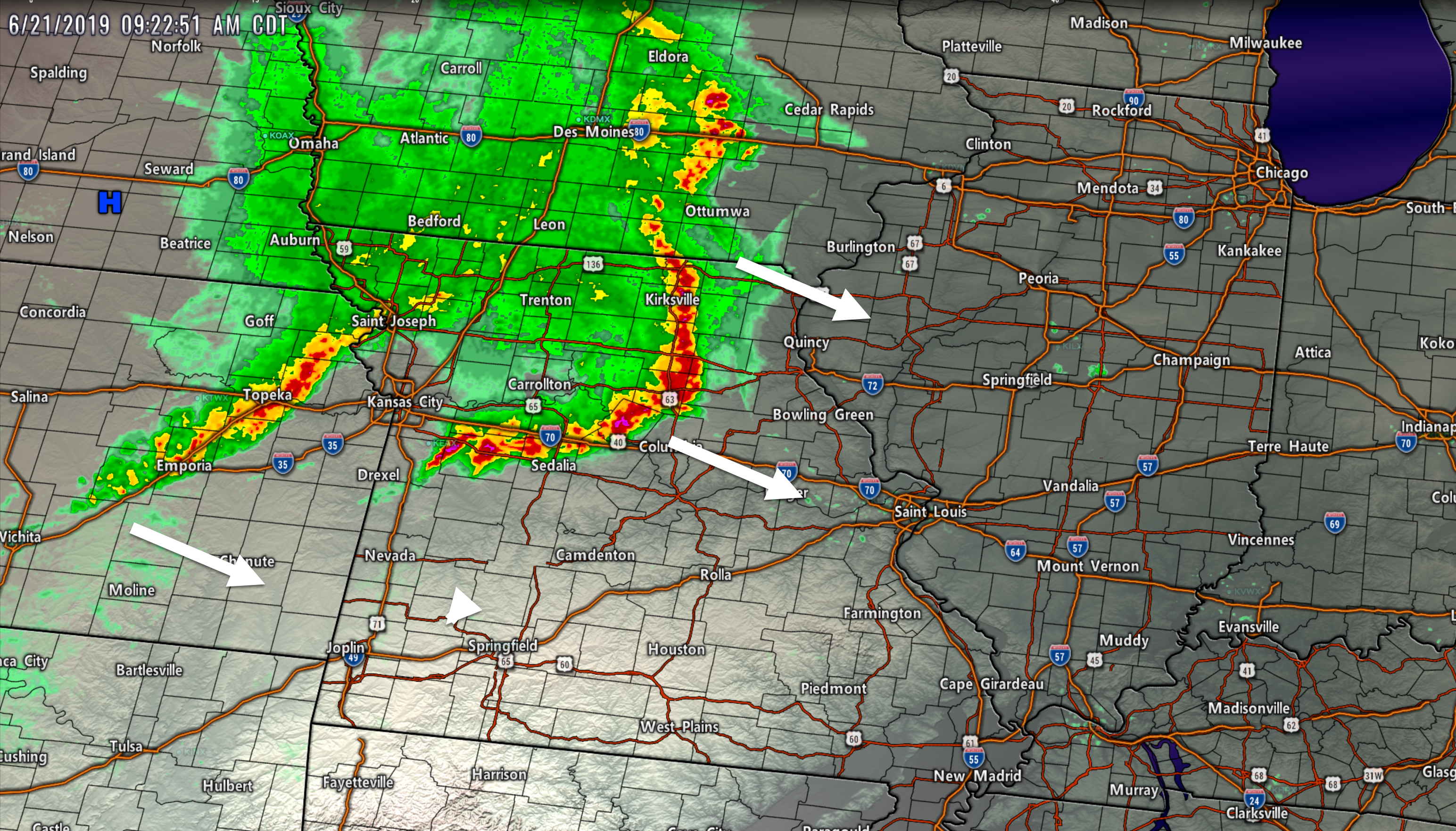
8:45 AM
Here is the IR satellite view.
Those red colors are very cold cloud tops. In other words, thunderstorms.
See this view yourself by click here. Hit refresh once there. That will show you the latest image.
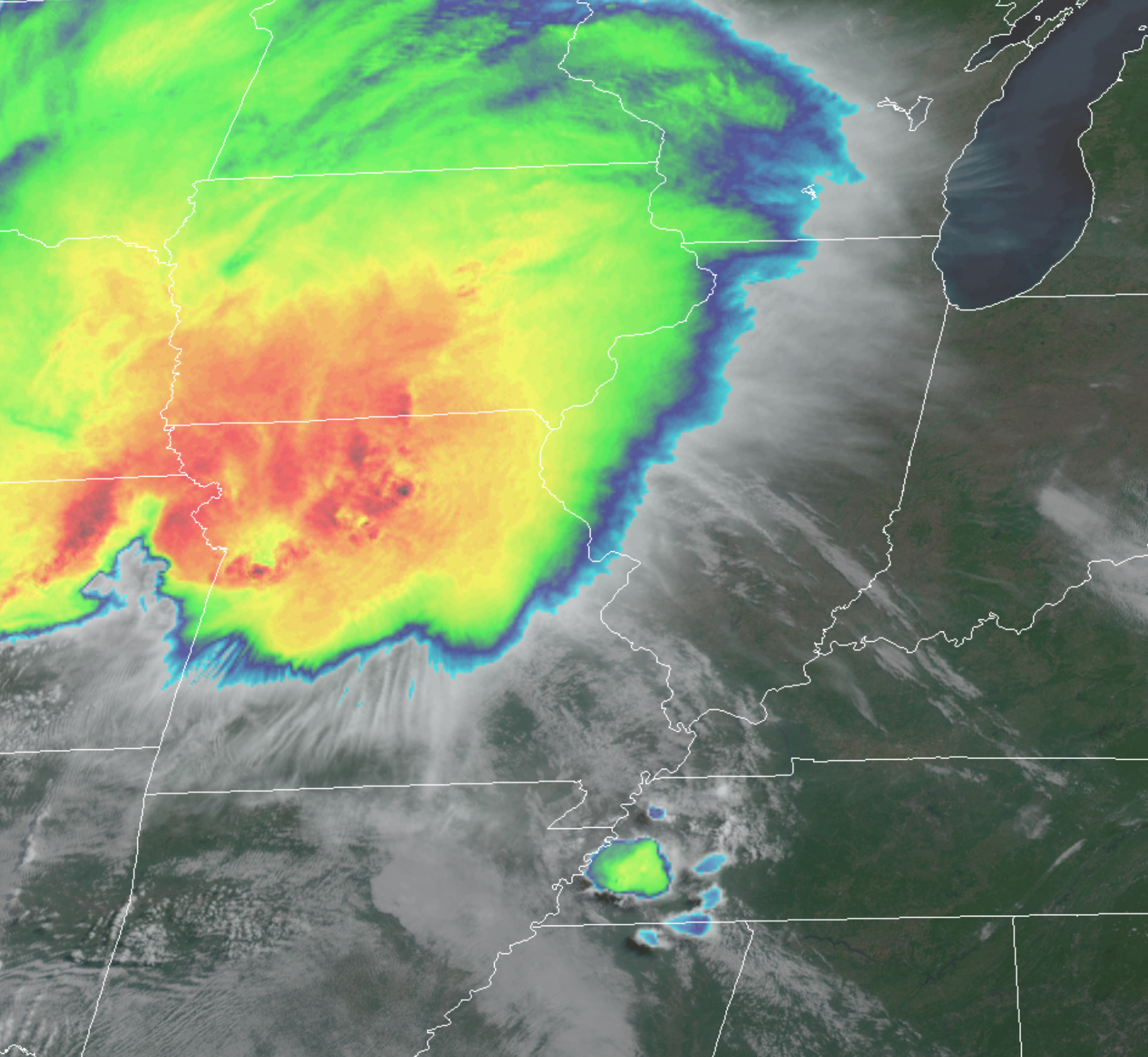
Another view from one of my weather software packages. This is an MCS. Mesoscale Convective System.
.
8:30 AM
A severe thunderstorm watch has been issued for portions of the region.
Click images to enlarge.
.
8:00 AM

.
Click here if you would like to return to the top of the page
.
These are bonus videos for subscribers.
I pay BAMwx to help with videos.
They do not currently have a Kentucky/Tennessee specific video.
The Ohio Valley video does capture our region.
.
Ohio Valley video
.

The Missouri Valley
.
** Severe Thunderstorms Likely **
Today’s regular blog update has been posted, as well. Link https://wtalk.co/4PWUDBZQ
.
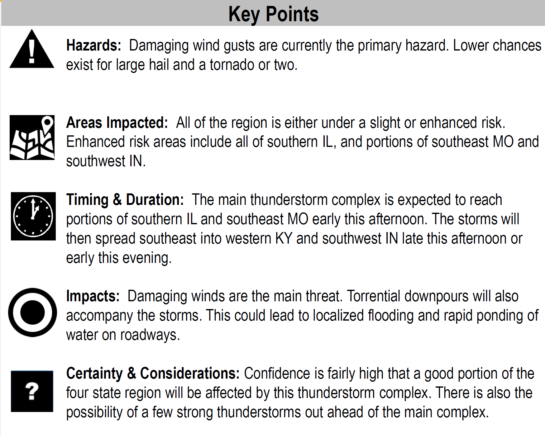
KEY MESSAGE
- Do not rely on WeatherTalk text messages (use the app). USE THE Beau Dodson WeatherTalk App. The app receives the same messages but instantly.
- A line of severe storms is tracking towards the area from northwest Kansas.
- The line will move east/southeast into this afternoon.
- Some of the thunderstorms will produce damaging wind, hail, torrential rain, frequent lightning, and even an isolated rain-wrapped tornado.
- Monitor updates today. Severe weather watches and warnings are likely.
- Wiespread/high-end severe weather is possible with wind gusts above 70 mph. Major tree damage anticipated.
- This is a potentially dangerous weather situation.
- It is possible we have more than one round of storms today into Saturday.
- Flash flooding is possible if storms train over the same area.
.
Track the storms below.
Radar Link: Interactive local city-view radars & regional radars.
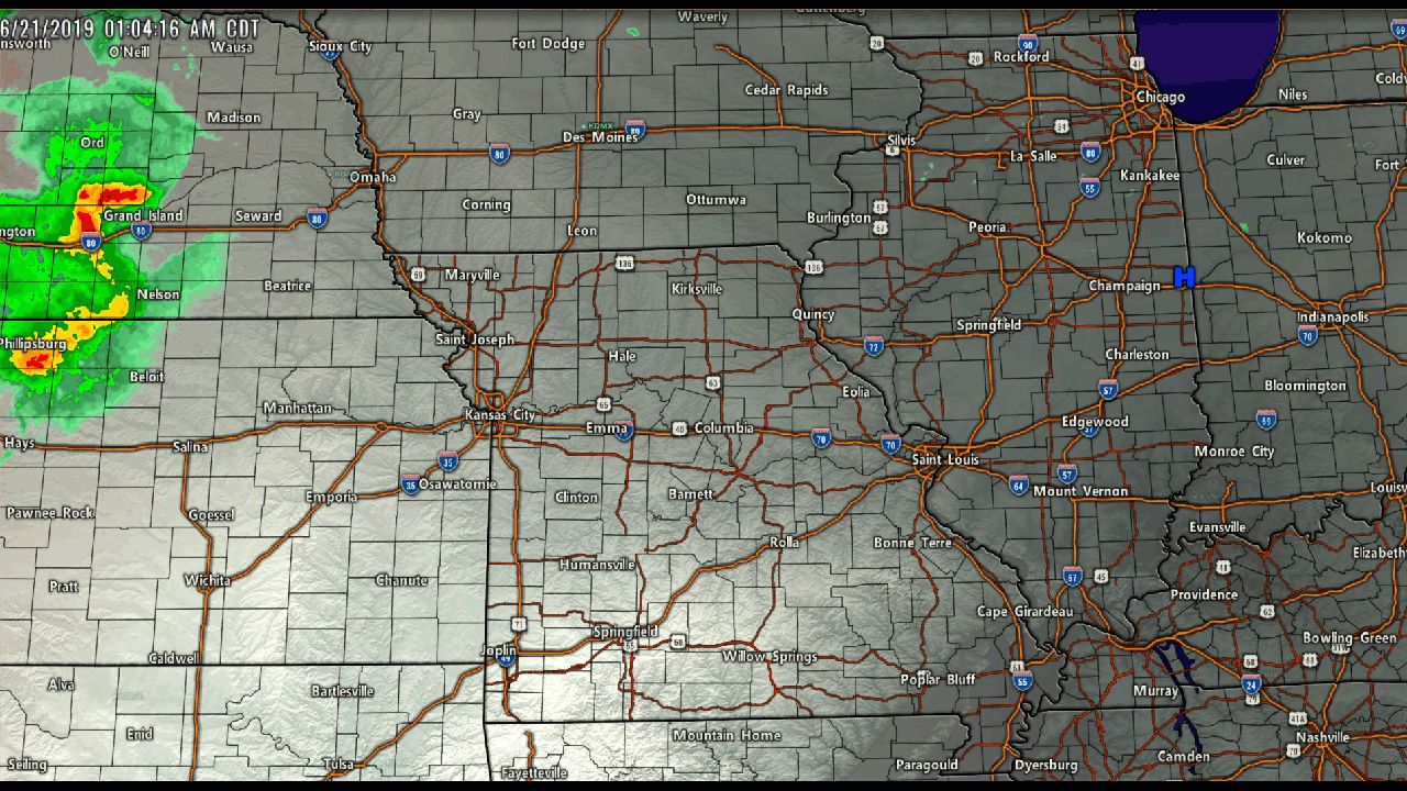
Here is a GIF that I made showing you the severe line of thunderstorms as it tracked eastward overnight.
This animation ends around 8 AM. See the link above for fresh radar data.
Click the image to enlarge.
.
The Storm Prediction Center has upgraded us to an enhanced risk of severe thunderstorms. That is a level three out of five risk. Five being the highest risk.
They will update this again around 11:30 AM.

.
Remember, a watch means to go about your business and monitor updates. A warning means to move to a safe place of shelter until the storm passes.

.
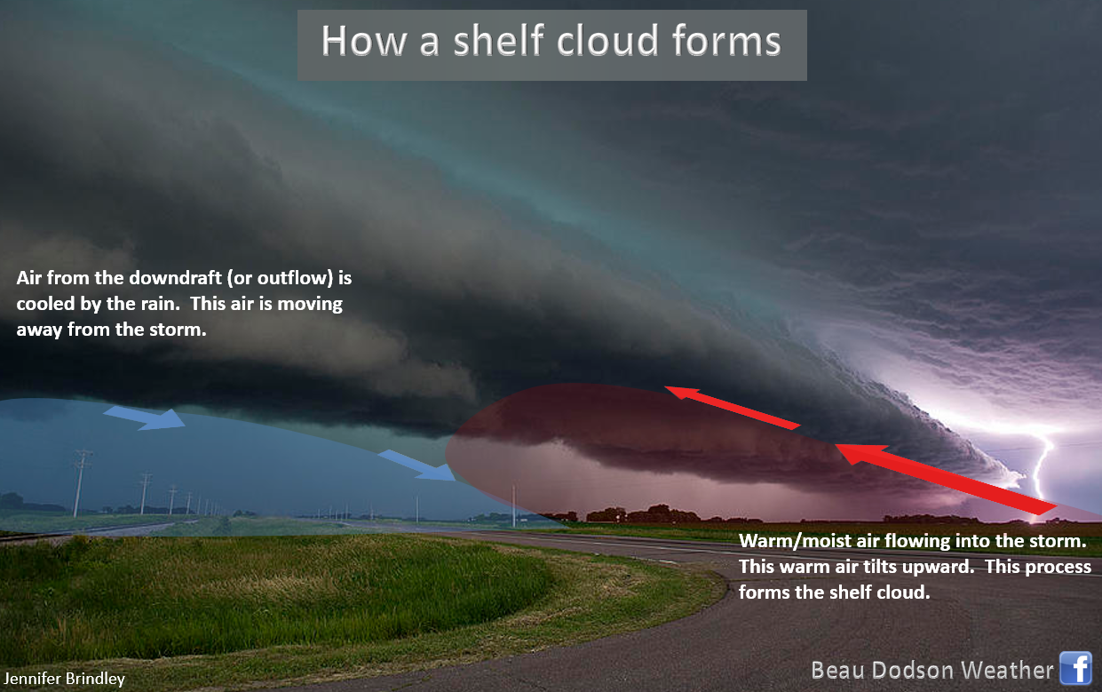
You will likely see a lot of shelf clouds today.
.
Make sure that you have not logged out of your app, accidentally. Open your app. Make sure it is active and receiving data.
Speaking of the app, use the app and not the texts. Texts can be delayed by ATT and Verizon. The app is instant. Use the app.
We have more heavy thunderstorms in the forecast.
Remember, this is what the model believes will happen. Models are never exact.
The model of choice today is this one here.
.
As you can see, a band of severe storms is forecast to push into the region later this morning and will last into the afternoon. It will move east and southeast. Additional storms are possible late tonight.
Very high winds are possible in this unstable atmosphere. Damage to trees and roofs are likely. Isolated tornadoes could also cause damage, esp in Kentucky.
.
Monitor updates. I will be on top of the situation. I will be sending out app messages as necessary.
Let’s take a look at a couple of maps.
Click maps to enlarge.
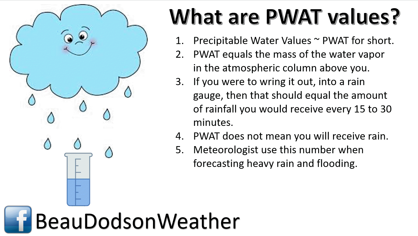
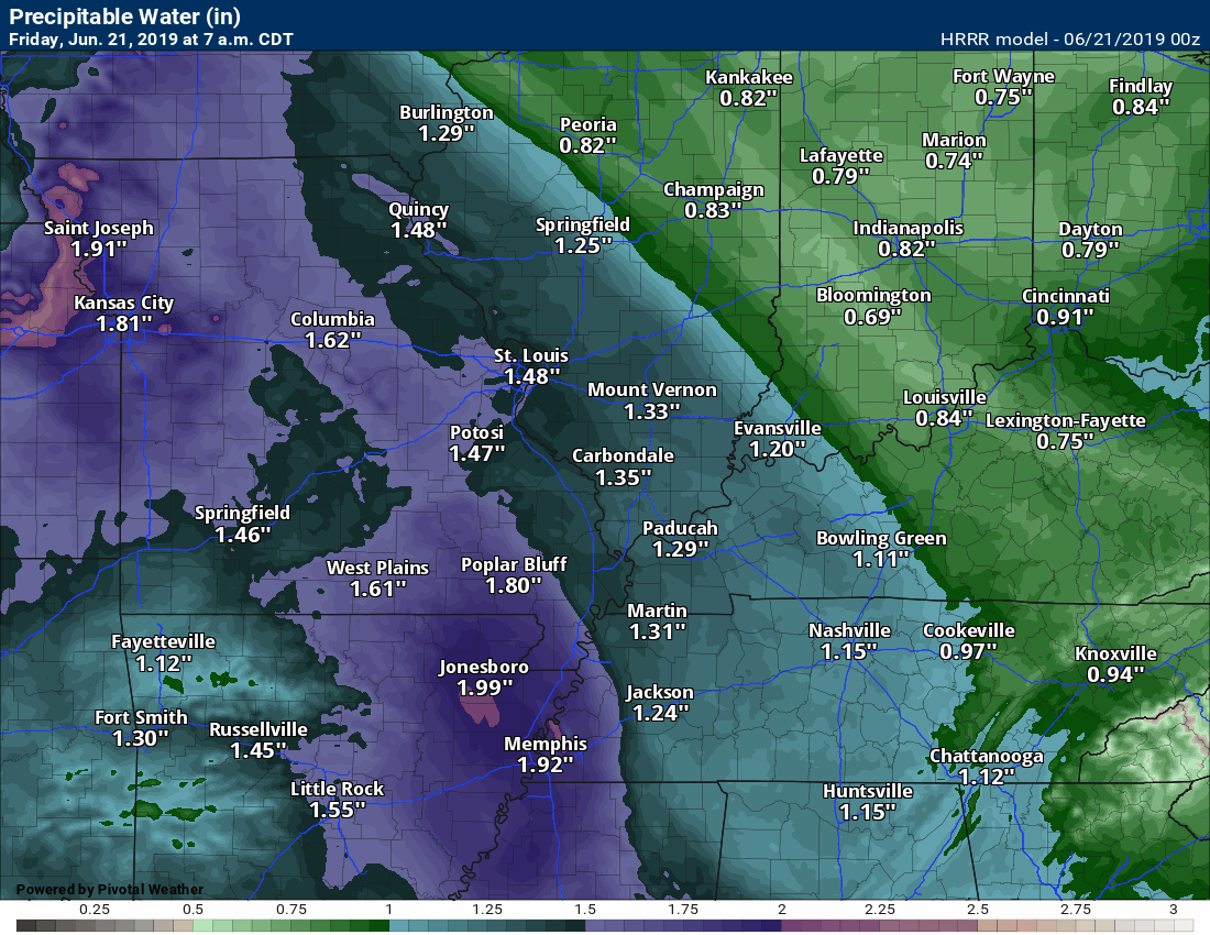
This is the PWAT value map. Very high numbers in the dark green zone.

.
CAPE values early this morning are already high.
Typically, these events track along the CAPE boundary. That would mean the complex of storms will push into our region.
CAPE is a measure of instability/energy. Storms tap into the CAPE.
.
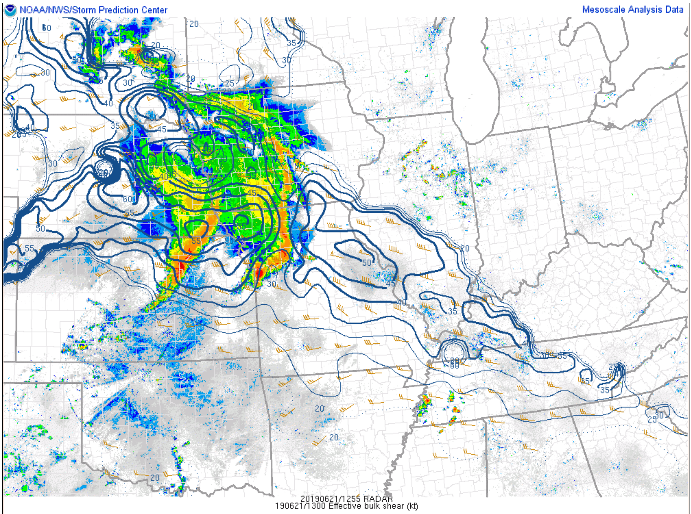
Here is the wind shear map. Wind shear is the increase of wind speed with height or changing of direction with height.
You can see the wind shear map here.
Notice how the wind shear also follows the gradient of CAPE? Another signal for what direction this system might track.
.
Portions of the region have experienced flash flooding over the past week. Some locations received three to five inches of rain in two to three hours on Sunday.
Additional heavy rain totals fell after that time-period.
The pattern remains unchanged. Periodic episodes of showers and heavy thunderstorms. This is going to continue into next week.
PWAT values remain high. Today we are looking at PWAT values of 1.6 to 1.9″. Those are tropical numbers. Just one more reason it feels so muggy outside.
High PWAT values are a signal for torrential tropical-like downpours. You can pick up 1.5″ to 2.5″ of rain in an hour. If a couple of thunderstorms train over the same area then flash flooding occurs.
.
.
Dew point temperatures will be on the miserable side of the index. Muggy.
.
Additional storm tracking quick links
STORM TRACKING TOOLS
Interactive city-view radars
http://weatherobservatory.com/weather-radar.htm
Clickable watches and warnings can be viewed on the local city-view interactive radars (link above). Be sure and turn on the warnings above the local radars.
A new regional radar we offer
https://imagery.weathertalk.com/prx/RadarLoop.mp4
Lightning data
https://wtalk.co/7QT7WHKU
Watches/warnings
https://imagery.weathertalk.com/prx/SevereAlerts.png
Infrared satellite
https://imagery.weathertalk.com/prx/IRSatelliteLoop.mp4
Visible satellite
Current conditions
https://imagery.weathertalk.com/prx/CurrentConditions.png
Current heat index or wind chill
https://imagery.weathertalk.com/prx/CurrentFeelsLike.png
Wind speed
https://imagery.weathertalk.com/prx/CurrentWindSpeed.png
Wind gust
https://imagery.weathertalk.com/prx/CurrentWindGust.png
Beau Dodson Weather App!
Have you downloaded the Beau Dodson Weather app?
Move to the app and do not depend on the text messages. The app receives the exact same messages but faster.
ATT and Verizon have been throttling the speed of texts.
The app receives them instantly.
Apple users: Beau Dodson Weather App
https://itunes.apple.com/us/app/id1190136514
Android users: Beau Dodson Weather App
https://play.google.com/store/apps/details?id=com.weathertalk.beaudodsonweather.android
.
Today’s SPC severe weather outlook (below).
Light green is where thunderstorms may occur but should be below severe levels.
Dark green is a level one risk. Yellow is a level two risk. Orange is a level three (enhanced) risk. Red is a level four (moderate) risk. Pink is a level five (high) risk.
One is the lowest risk. Five is the highest risk.
Light green is not assigned a number. Light green is where storms may occur but should be below severe levels.
A severe storm is one that produces 60 mph winds or higher, quarter size hail, and/or a tornado. One or more of those is defined as a severe thunderstorm.

The black outline is our local area.
.
Not receiving app/text messages?
Make sure you have the correct app/text options turned on. Find those under the personal notification settings tab at www.weathertalk.com. Red is off. Green is on.
Subscribers, PLEASE USE THE APP. ATT and Verizon are not reliable during severe weather. They are delaying text messages.
The app is under Beau Dodson Weather in the app store.

Apple users click here

Android users click here
.

.

.
.
Today’s outlook (below).
Light green is where thunderstorms may occur but should be below severe levels.
Dark green is a level one risk. Yellow is a level two risk. Orange is a level three (enhanced) risk. Red is a level four (moderate) risk. Pink is a level five (high) risk.
One is the lowest risk. Five is the highest risk.
Light green is not assigned a number. Light green is where storms may occur but should be below severe levels.
A severe storm is one that produces 60 mph winds or higher, quarter size hail, and/or a tornado. One or more of those is defined as a severe thunderstorm.
The black outline is our local area.
.
Tomorrow’s outlook.
Light green is where thunderstorms may occur but should be below severe levels.
Dark green is a level one risk. Yellow is a level two risk. Orange is a level three (enhanced) risk. Red is a level four (moderate) risk. Pink is a level five (high) risk.
One is the lowest risk. Five is the highest risk. Light green is not assigned a number.


.
.
Here is the latest graphic from the WPC/NOAA.
24-hour precipitation outlook.
.

.
48-hour precipitation outlook.
.
.
.
72-hour precipitation outlook.
.

.
Days one through seven added together. Seven-day rainfall totals.

.
Radar Link: Interactive local city-view radars & regional radars.
You will find clickable warning and advisory buttons on the local city-view radars.
If the radar is not updating then try another one. If a radar does not appear to be refreshing then hit Ctrl F5. You may also try restarting your browser.
Not working? Email me at beaudodson@usawx.com
National map of weather watches and warnings. Click here.
Storm Prediction Center. Click here.
Weather Prediction Center. Click here.
.
Live lightning data: Click here.
.

Interactive GOES R satellite. Track clouds. Click here.
GOES 16 slider tool. Click here.
College of Dupage satellites. Click here
.

Here are the latest local river stage forecast numbers Click Here.
Here are the latest lake stage forecast numbers for Kentucky Lake and Lake Barkley Click Here.
.
Did you know that you can find me on Twitter? Click here to view my Twitter weather account.

.

.
Who do you trust for your weather information and who holds them accountable?
I have studied the weather in our region since the late 1970s. I have 40 years of experience in observing our regions weather patterns.
My degree is in Broadcast Meteorology from Mississippi State University and a Bachelor of Science (BS).
I am an NOAA Weather-Ready Nation Ambassador. I am the Meteorologist for McCracken County rescue squad. When asked, I assist Ballard and Massac Counties, as well.
I own and operate the Southern Illinois Weather Observatory and WeatherTalk LLC.
There is a lot of noise on the internet. Over time you should learn who to trust for your weather information.
My forecast philosophy is simple and straight forward.
- Communicate in simple terms
- To be as accurate as possible within a reasonable time frame before an event
- Interact with you on Twitter, Facebook, and the blog
- Minimize the “hype” that you might see on television or through other weather sources
- Push you towards utilizing wall-to-wall LOCAL TV coverage during severe weather events
I am a recipient of the Mark Trail Award, WPSD Six Who Make A Difference Award, Kentucky Colonel, and the Caesar J. Fiamma” Award from the American Red Cross.
In 2009 I was presented with the Kentucky Office of Highway Safety Award.
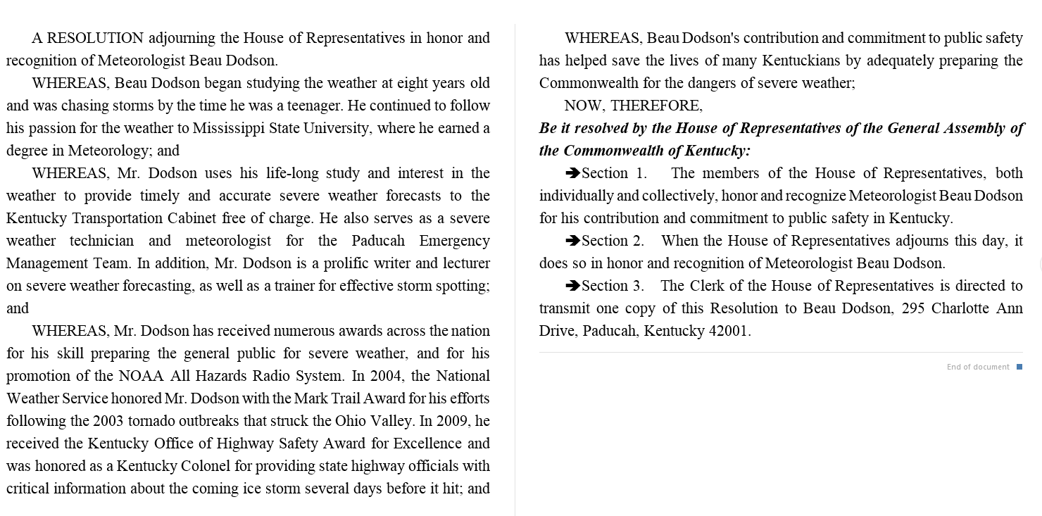
I was recognized by the Kentucky House of Representatives for my service to the State of Kentucky leading up to several winter storms and severe weather outbreaks.
If you click on the image below you can read the Kentucky House of Representatives Resolution.
.
.
Previous episodes can be viewed by clicking here.
.
Find Beau on Facebook! Click the banner.

.
Find Beau on Twitter! Share your weather photos! @beaudodson

.
Did you know that a portion of your monthly subscription helps support local charity projects? Not a subscriber? Becoming one at www.weathertalk.com
You can learn more about those projects by visiting the Shadow Angel Foundation website and the Beau Dodson News website.
