

.
I have some question-and-answer threads over on the Facebook page. Link to those threads CLICK HERE
Or email me at beaudodsonweather@gmail.com
.

🌪️ Seven-Day Tornado Outlook ⛈️
June 19th through June 25th
Current risk: None.
Current confidence level: High confidence in the forecast.
Comment: No tornado threats.
.

Seven-Day Hazardous Weather Outlook
1. Is lightning in the forecast? LOW RISK. There is a low risk of lightning Monday through Wednesday. For the most part, the forecast is currently hot and dry.
2. Are severe thunderstorms in the forecast? NO.
3. Is flash flooding in the forecast? NO.
4. Will non-thunderstorm winds top 40 mph? NO.
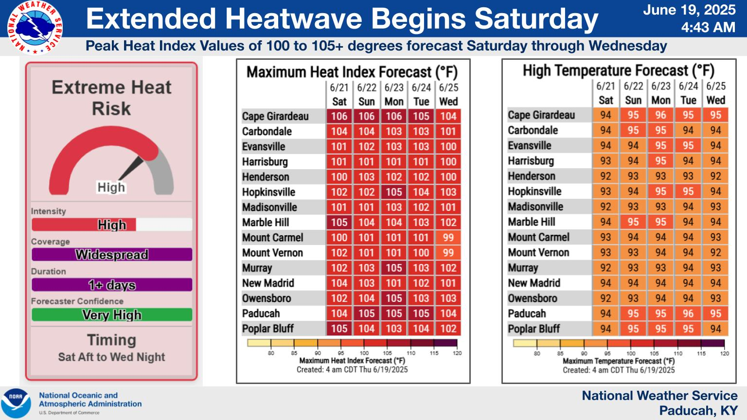
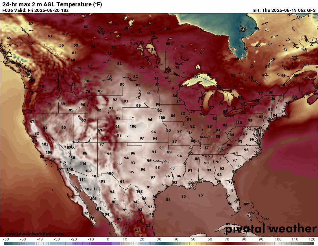
5. Will temperatures rise above 90 degrees? YES. Temperatures may reach 90°F or higher Friday into much of next week.
6. Will the heat index rise above 100 degrees? YES. Heat index values are expected to approach and exceed 100 degrees this weekend into next week. Use caution in the heat.
Double click on this graphic to enlarge it. Notice the heat index values.
.
The heat index factors in both the actual air temperature and the amount of moisture in the air (relative humidity).
.
Perceived Temperature:
High humidity makes it harder for the body to cool itself through sweating, so the perceived temperature is higher than the actual temperature.
.
Heat-Related Illnesses:
When the heat index is high, the risk of heat-related illnesses, such as heat cramps, heat exhaustion, and heat stroke, increases, especially with prolonged exposure to the heat or physical activity.
.
Shade vs. Sunlight:
The heat index is typically calculated for shaded areas. Exposure to direct sunlight can further increase the perceived temperature.
.
A quick forecast glance. Your 48-hour forecast Graphics


.

.


Forecast discussion.
- Here comes summer.
- Hot and muggy weather Friday into much of next week.
- High heat index values are expected tomorrow and into next week.
- A small chance of isolated storms next Tuesday through Thursday. For now, rain chances are at 20% or less.
.

Good day, everyone
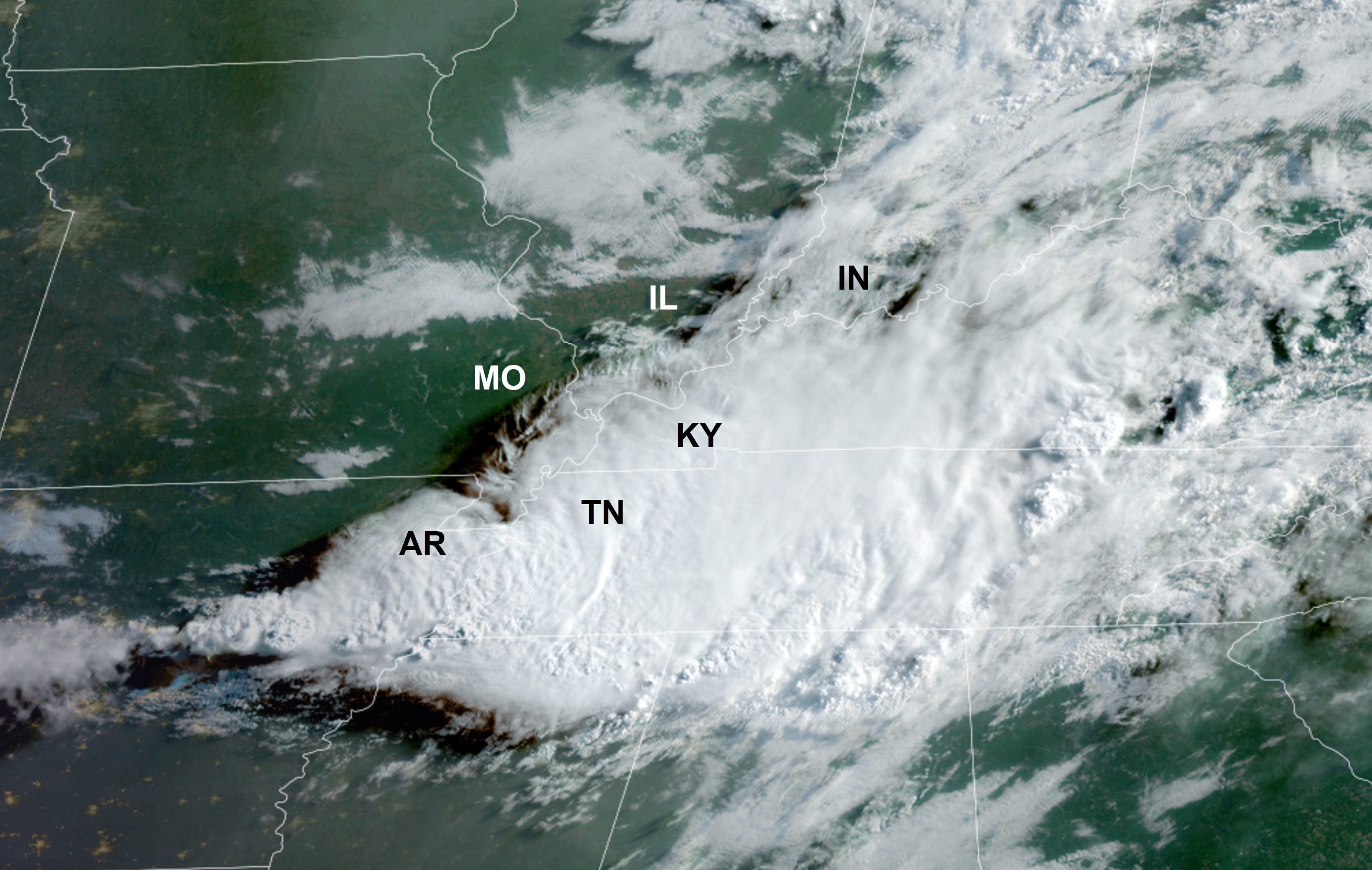
It was a stormy 24 hours. We experienced several severe thunderstorms yesterday afternoon and night.
There were reports of quarter-sized hail and 70+ mph wind gusts. There was some damage in southern Illinois and western Kentucky. Northwest Tennessee, as well.
Thankfully, the extent of the damage was limited. All in all, about what was anticipated.
Not everyone experienced storms. That is not uncommon during the summer months.
The wet pattern is finally coming to an end.
A few showers are lingering in the region this morning, but those are winding down and moving southeast.
Much of the region will be dry today. A bit humid. Some lingering clouds.
Here is the 7:00 a.m. satellite view.
You can see the clearing to our north and west. That will slowly move eastward.
No weather concerns (rainwise) Friday through early next week.
The weather concern will be the heat.
Our first summer heatwave will begin on Friday and will linger into much of next week.
We are expecting widespread 90s Friday through at least next Wednesday.
Heat index values will jump above 100 degrees during the afternoon hours.
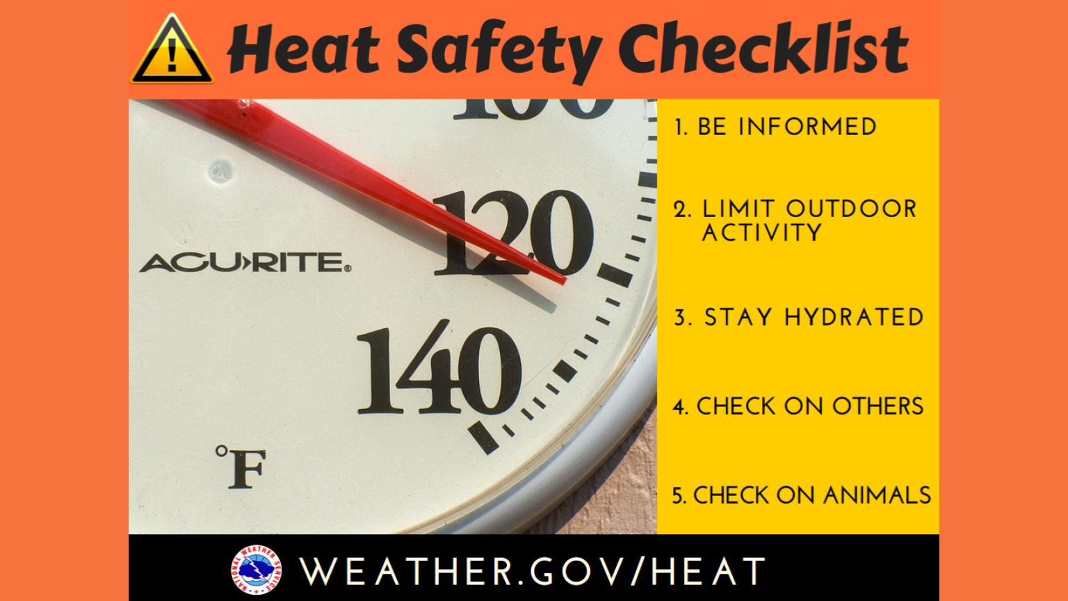
Not ideal outdoor weather for those without air conditioning or those who have to work in the heat.
Take standard summer heat precautions.
Rain chances will be less than 10% Friday through Tuesday. They may increase to around 20% by next Wednesday and Thursday.
Double-click the animation to enlarge it. Here is the GFS high temperature animation through next week.
A prolonged period of heat and humidity.
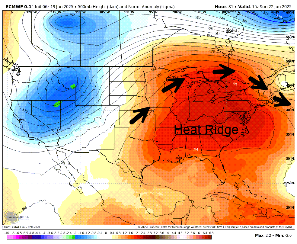
The reason for the heat will be a ridge. A ridge typically means heat during the summer months.
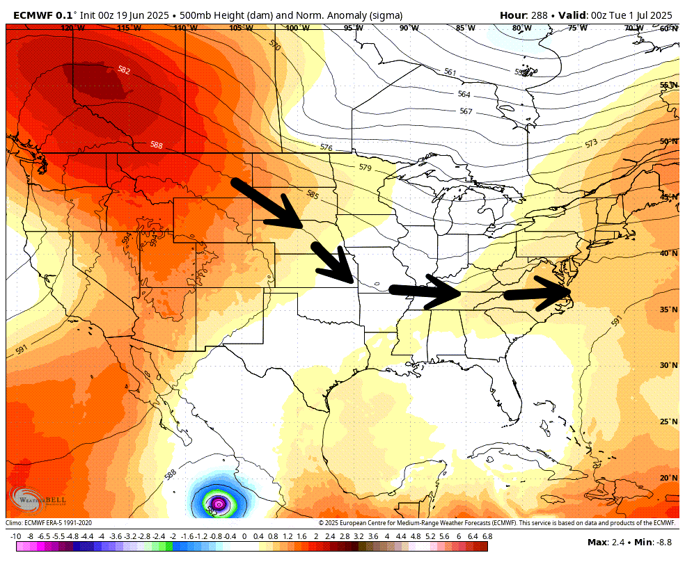
Sunday’s 500 mb upper air map. Jetstream flow.
Next Tuesday’s map
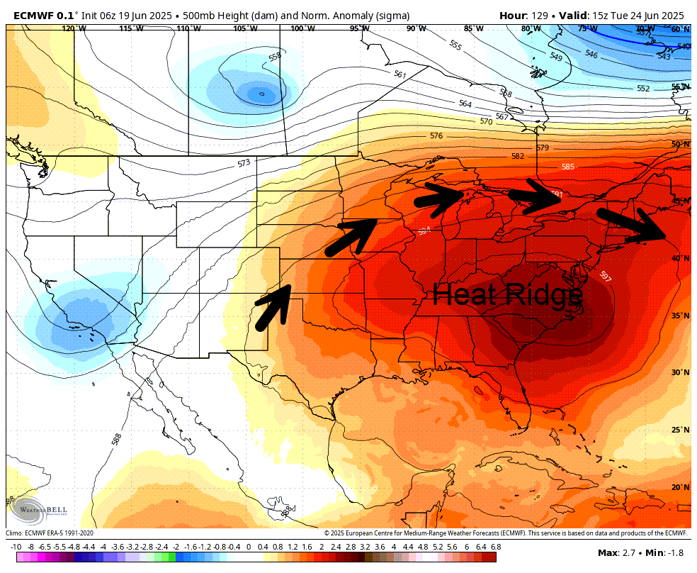
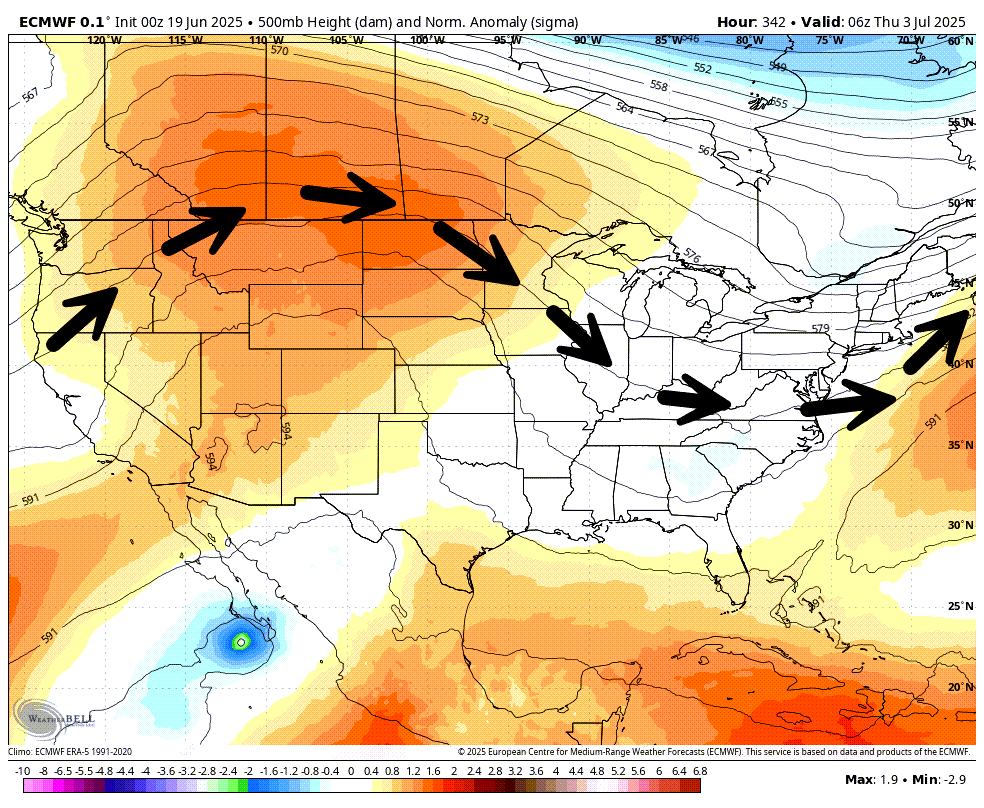
How long does the ridge linger? That is the biggest question.
The EC breaks it down around the end of the month. That would mean higher chances of rain. Long way off. I will monitor trends.
When the ridge breaks down, then northwest flow can develop. Northwest flow can bring showers and thunderstorms.
July 1st. Jetstream flow.
July 3rd
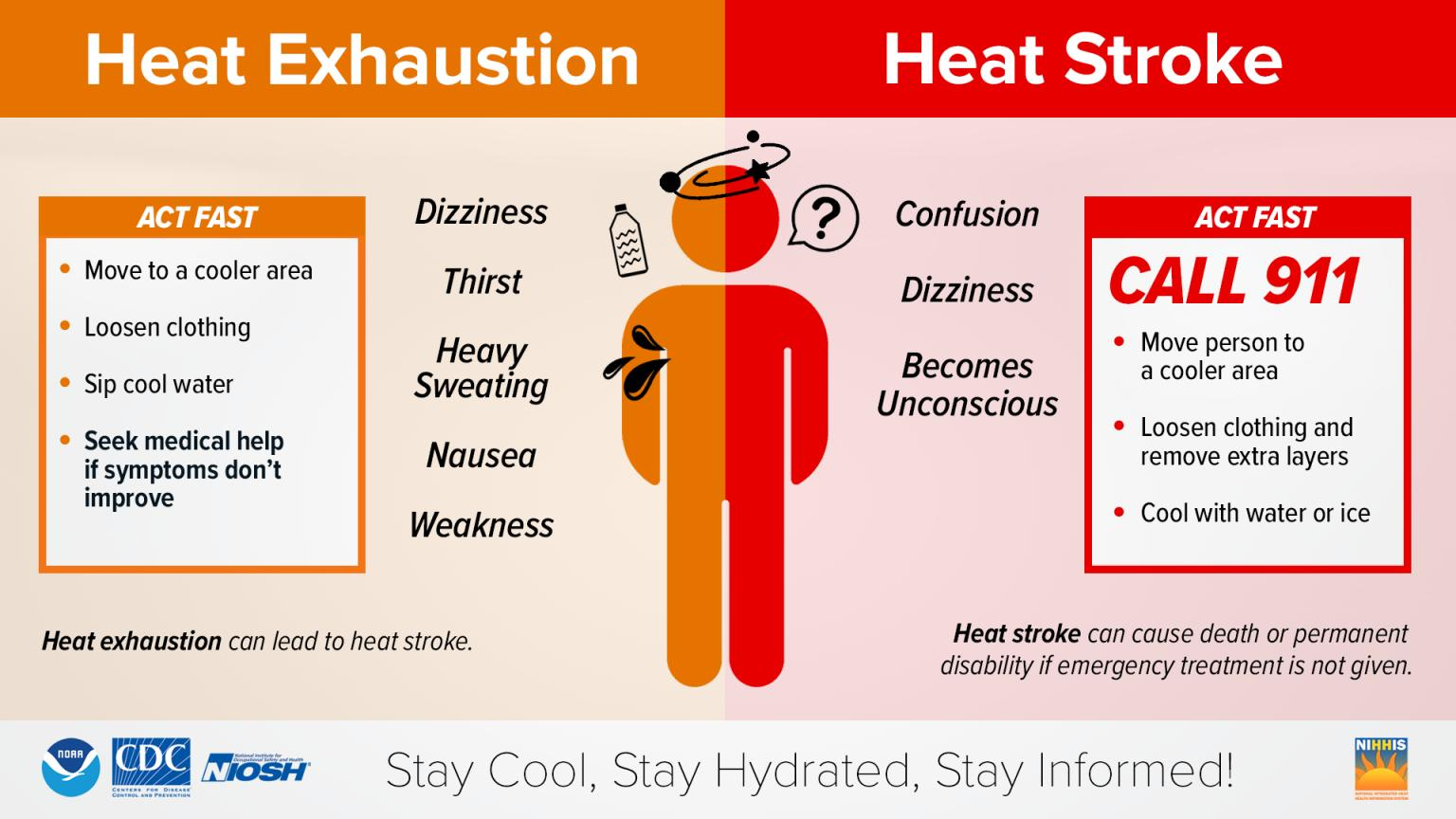
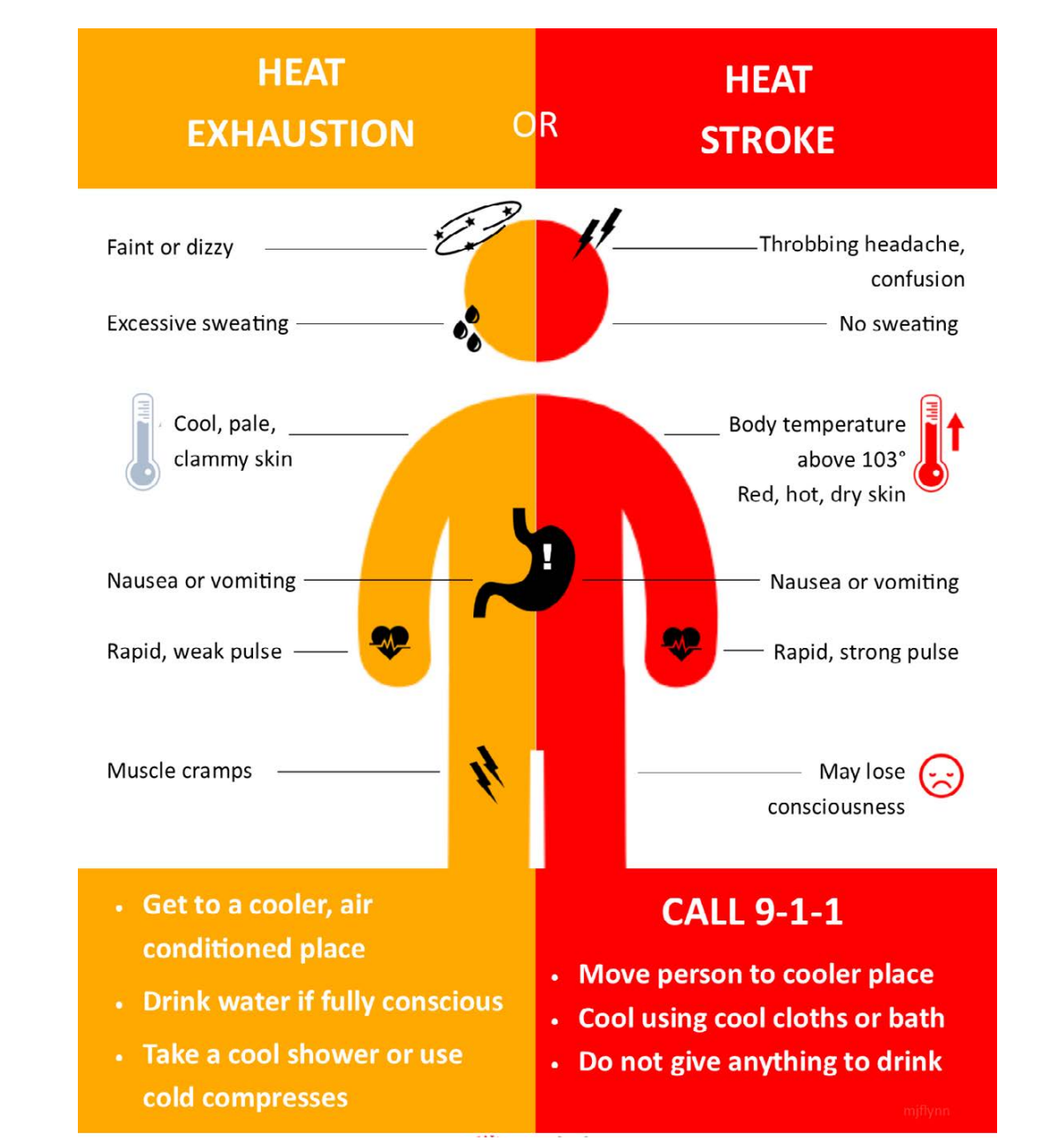
Know the signs of heat illness.
.

The timestamp (upper left) is in Zulu. 12z=7 am. 18z=1 pm. 00z=7 pm.
Double-click the animation to enlarge it.
Hrrr model
Rain is not anticipated.
.
NAM 3K model..
The timestamp (upper left) is in Zulu. 12z=7 am. 18z=1 pm. 00z=7 pm.
Rain is not anticipated.
..
.
Click here if you would like to return to the top of the page.
.Average high temperatures for this time of the year are around 86 degrees.
Average low temperatures for this time of the year are around 65 degrees.
Average precipitation during this time period ranges from 1.00″ to 1.40″
Six to Ten Day Outlook.
Blue is below average. Red is above average. The no color zone represents equal chances.
Average highs for this time of the year are in the lower 60s. Average lows for this time of the year are in the lower 40s.

Green is above average precipitation. Yellow and brown favors below average precipitation. Average precipitation for this time of the year is around one inch per week.

.

Average low temperatures for this time of the year are around 65 degrees.
Average precipitation during this time period ranges from 1.20″ to 1.50″
.
Eight to Fourteen Day Outlook.
Blue is below average. Red is above average. The no color zone represents equal chances.

Green is above average precipitation. Yellow and brown favors below average precipitation. Average precipitation for this time of the year is around one inch per week.

.
.
.
We have a new service to complement your www.weathertalk.com subscription. This does NOTreplace www.weathertalk.com It is simply another tool for you to receive severe weather information.
.
https://weathercallservices.com/beau-dodson-weather


I am going to start going live during bigger severe weather events.
Check it out here https://www.youtube.com/user/beaudodson
Click the subscribe button (it’s a free subscription button), and it will alert you when I go live. I will also send out alerts to the app when I go live for an event.

.

Radars and Lightning Data
Interactive-city-view radars. Clickable watches and warnings.
https://wtalk.co/B3XHASFZ
Old legacy radar site (some of you like it better)
https://weatherobservatory.com/weather-radar.htm
If the radar is not updating then try another one. If a radar does not appear to be refreshing then hit Ctrl F5. You may also try restarting your browser.
Backup radar site in case the above one is not working.
https://weathertalk.com/morani
Regional Radar
https://imagery.weathertalk.com/prx/RadarLoop.mp4
** NEW ** Zoom radar with chaser tracking abilities!
ZoomRadar
If the radar is not working, then email me: Email me at beaudodson@usawx.com
.
We do have some sponsors! Check them out.
Roof damage from recent storms? Link – Click here
INTEGRITY ROOFING AND EXTERIORS!
⛈️ Roof or gutter damage from recent storms? Today’s weather is sponsored by Integrity Roofing. Check out their website at this link https://www.ourintegritymatters.com/

![]()
![]()
![]()
Make sure you have three to five ways of receiving your severe weather information.
Weather Talk is one of those ways! Now, I have another product for you and your family.

.
Want to add more products to your Beau Dodson Weather App?
Receive daily videos, weather blog updates on normal weather days and severe weather and winter storm days, your county by county weather forecast, and more!
Here is how to do add those additional products to your app notification settings!
Here is a video on how to update your Beau Dodson Weather payment.
The app is for subscribers. Subscribe at www.weathertalk.com/welcome then go to your app store and search for WeatherTalk
Subscribers, PLEASE USE THE APP. ATT and Verizon are not reliable during severe weather. They are delaying text messages.
The app is under WeatherTalk in the app store.

Apple users click here

Android users click here
.
Radars and Lightning Data
Interactive-city-view radars. Clickable watches and warnings.
https://wtalk.co/B3XHASFZ
Old legacy radar site (some of you like it better)
https://weatherobservatory.com/weather-radar.htm
If the radar is not updating then try another one. If a radar does not appear to be refreshing then hit Ctrl F5. You may also try restarting your browser.
Backup radar site in case the above one is not working.
https://weathertalk.com/morani
Regional Radar
https://imagery.weathertalk.com/prx/RadarLoop.mp4
** NEW ** Zoom radar with chaser tracking abilities!
ZoomRadar
Lightning Data (zoom in and out of your local area)
https://wtalk.co/WJ3SN5UZ
Not working? Email me at beaudodson@usawx.com
National map of weather watches and warnings. Click here.
Storm Prediction Center. Click here.
Weather Prediction Center. Click here.
.

Live lightning data: Click here.
Real time lightning data (another one) https://map.blitzortung.org/#5.02/37.95/-86.99
Our new Zoom radar with storm chases
.
.

Interactive GOES R satellite. Track clouds. Click here.
GOES 16 slider tool. Click here.
College of DuPage satellites. Click here
.

Here are the latest local river stage forecast numbers Click Here.
Here are the latest lake stage forecast numbers for Kentucky Lake and Lake Barkley Click Here.
.
.
Find Beau on Facebook! Click the banner.


 .
.