

.
I have some question-and-answer threads over on the Facebook page. Link to those threads CLICK HERE
Or email me at beaudodsonweather@gmail.com
I am going to start going live during bigger severe weather events.
Check it out here https://www.youtube.com/user/beaudodson
Click the subscribe button (it’s a free subscription button), and it will alert you when I go live. I will also send out alerts to the app when I go live for an event.

.

🌪️ Seven-Day Tornado Outlook ⛈️
June 16th through June 22nd
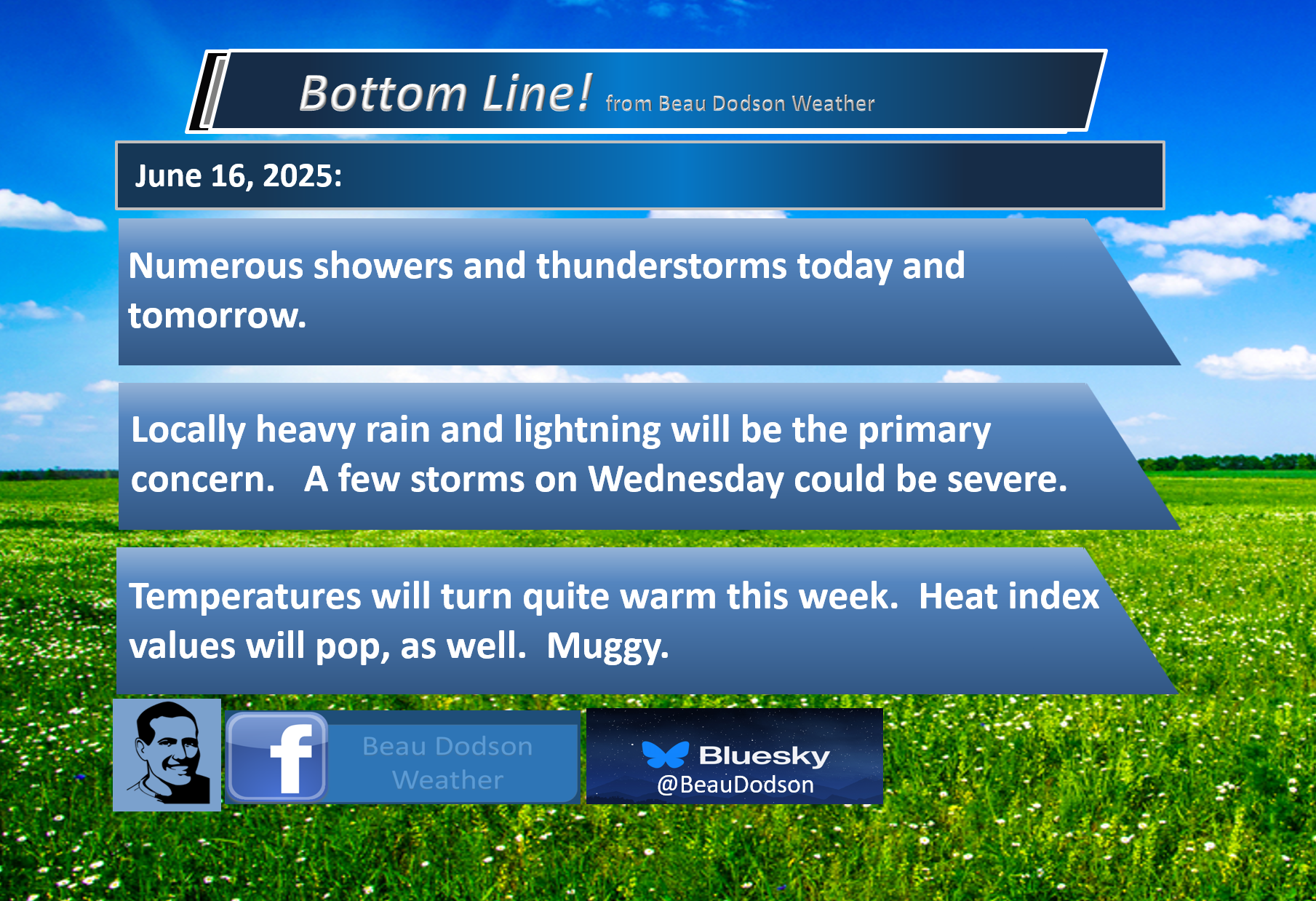
Current risk: LOW RISK OF TORNADOES.
Current confidence level: High confidence in the forecast.
Comment: The risk of tornadoes is low. A few thunderstorms could be severe on Wednesday/Wednesday night. Currently, the primary concern is damage from wind and hail. The risk of tornadoes is small.
.

Seven-Day Hazardous Weather Outlook
1. Is lightning in the forecast? YES. Lightning is possible today through Thursday. The risk of lightning Friday through Sunday is small. If lightning threatens, move indoors.
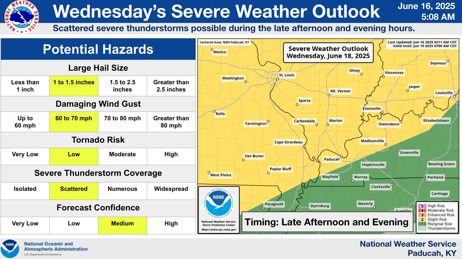
2. Are severe thunderstorms in the forecast? YES. A stronger storm system will bring a chance of severe weather to the region on Wednesday/Wednesday night. The primary concern is large hail and damaging wind gusts.
Most likely during the afternoon and evening.
The Storm Prediction Center has outlined our region in a level one and two risk zone.
.
Also, thunderstorms during the summer months can produce isolated, damaging wind gusts. Downburst winds. This can occur with little or no warning.
.
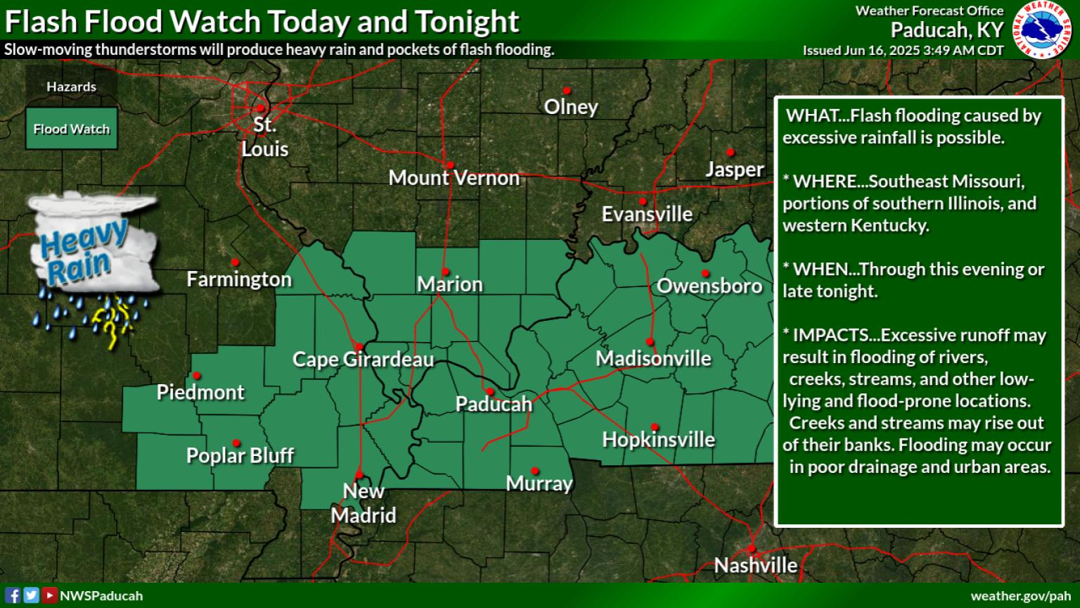
3. Is flash flooding in the forecast? SCATTERED. Locally heavy thunderstorms are likely today into Wednesday. Some storms could produce torrential downpours. There will be plenty of moisture in the atmosphere. Thunderstorms will tap into that moisture and produce heavy downpours. A few reports of flash flooding will be possible.
The NWS has issued a flash flood watch for today and a portion of tonight.
.
4. Will non-thunderstorm winds top 40 mph? NO.
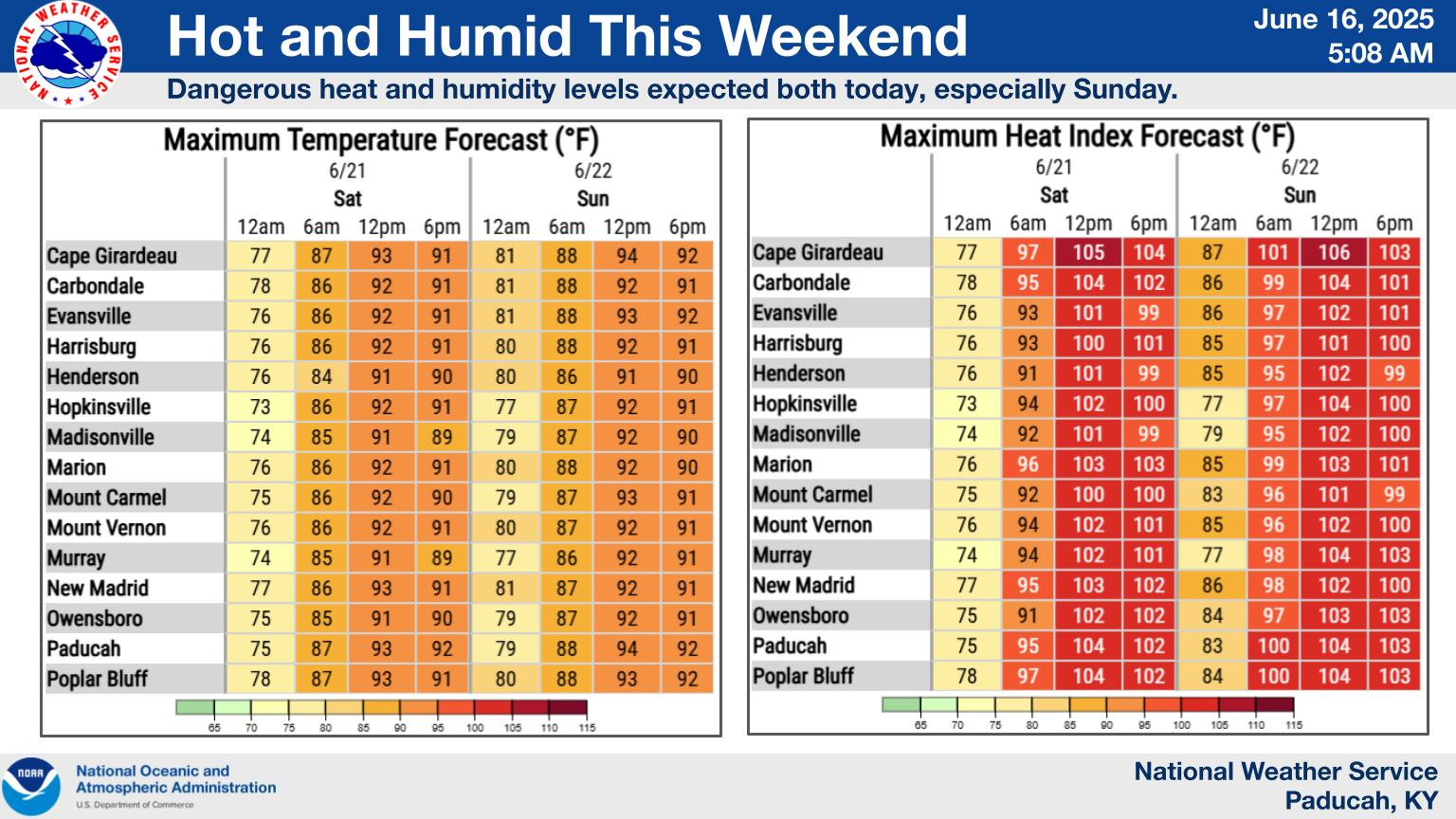
5. Will temperatures rise above 90 degrees? YES. Temperatures may reach 90°F or higher tomorrow and into the weekend. Peak heating is expected to occur on Friday, Saturday, and Sunday.
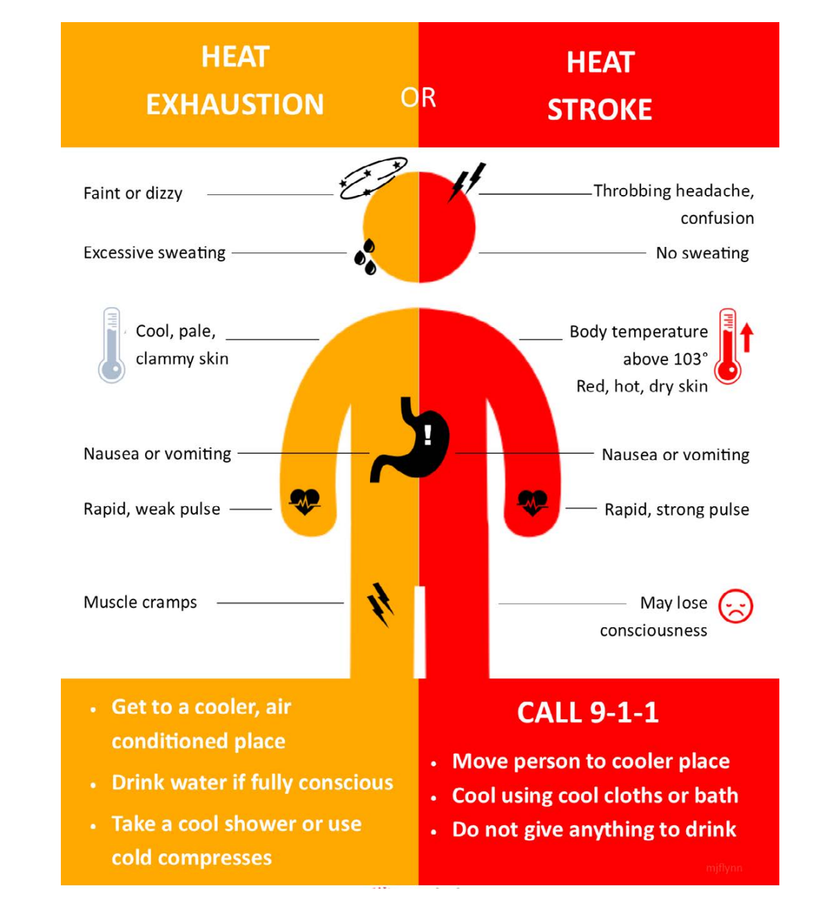
6. Will the heat index rise above 100 degrees? YES. Heat index values are expected to approach and exceed 100 degrees this weekend. Use caution in the heat.
Double click on this graphic to enlarge it. Notice the Saturday and Sunday heat index values.
-
Temperature and Humidity:The heat index factors in both the actual air temperature and the amount of moisture in the air (relative humidity).
-
Perceived Temperature:High humidity makes it harder for the body to cool itself through sweating, so the perceived temperature is higher than the actual temperature.
-
Heat-Related Illnesses:When the heat index is high, the risk of heat-related illnesses, such as heat cramps, heat exhaustion, and heat stroke, increases, especially with prolonged exposure to the heat or physical activity.
-
Shade vs. Sunlight:The heat index is typically calculated for shaded areas. Exposure to direct sunlight can further increase the perceived temperature.
.
A quick forecast glance. Your 48-hour forecast Graphics


.

.


Forecast discussion.
- More showers and thunderstorms.
- Locally heavy rain downpours. Lightning, as well.
- A stronger system is expected to bring a threat of severe weather to the region on Wednesday/Wednesday night.
- Hot and muggy this weekend. It should finally be mostly dry Friday through Sunday. Tiny storm chances.
.

I hope you had a nice weekend. Rain or shine. Seems we can’t shake the weekend rain events.
The good news is that this coming weekend is expected to be dry and hot. Muggy, as well. Swimming pool weather for some? Looks that way.
A couple of systems will pass through our region today and tomorrow. Each one will bring a round of showers and thunderstorms.
One round is moving through this morning. Another round is expected to move through this afternoon and evening.
Each round could bring locally heavy rain. There is plenty of moisture in the atmosphere. Thunderstorms will tap into that moisture and produce heavy tropical downpours.
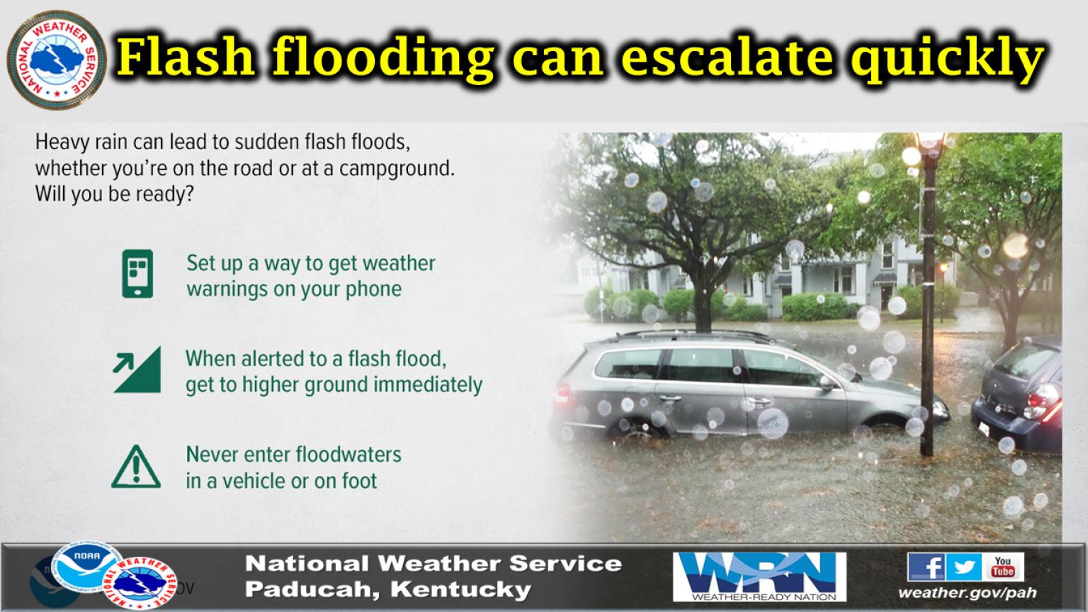
Rainfall totals in a few spots could reach three (or more) inches. Slow-moving thunderstorms can produce one to three inches of rain in an hour or less. This could result in localized flash flooding. Thus, the NWS has issued a flash flood watch for today and tonight.
Avoid flooded roadways, as always.
A stronger summer storm system will push into the region on Wednesday and Wednesday evening.
This system will produce scattered thunderstorms. Some of the thunderstorms could produce damaging wind gusts and large hail. Most likely quarter size. Perhaps slightly higher in the most intense thunderstorms.
Wind shear will be modest, but sufficient for severe weather.
We are in a level one and two severe weather risk for mainly Wednesday afternoon and evening.
At this time, the tornado risk appears low, but perhaps not zero. Any time you have severe thunderstorms, you have to monitor the tornado threat, as well.
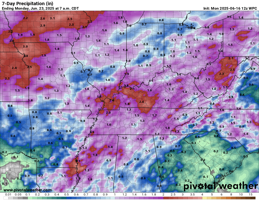
Rainfall totals this week will vary GREATLY. Typical for the summer. Generally, many areas will pick up 0.50″ to 1.00″ of rain through Thursday. Then, some locations will receive more than three inches. Slow-moving thunderstorms can produce large rain differences from county to county.
Double click on this graphic to enlarge it.
Rain chances will be lower on Thursday, Friday, Saturday, and Sunday. I hope it stays dry from Friday through Sunday. Perhaps a 10% chance or less of thunderstorms.
It will be hot and muggy Friday into Sunday. Highs will pop above 90 degrees in many locations. Heat index values of 95 to 105 degrees are likely.
A summer weekend!

Know the signs of heat illness.
.
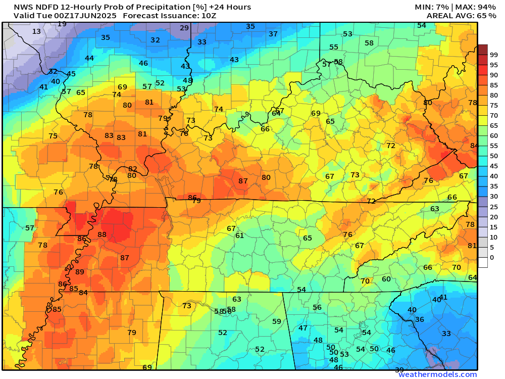
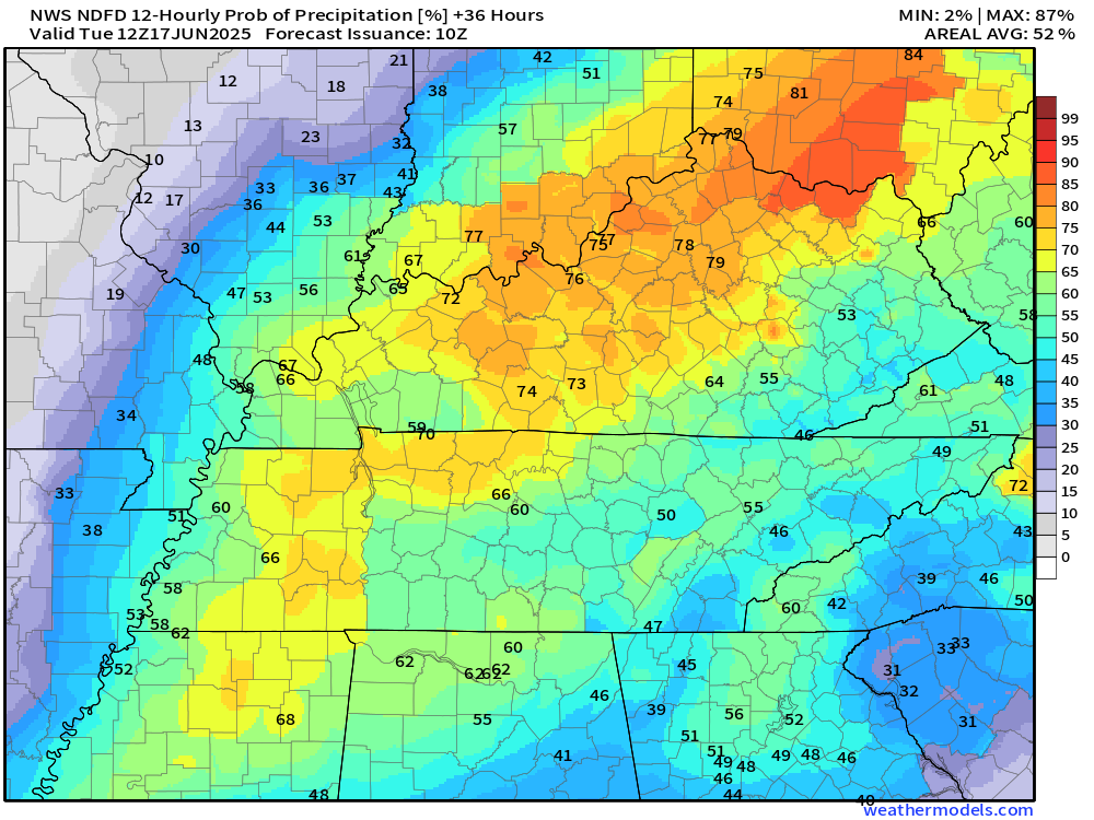
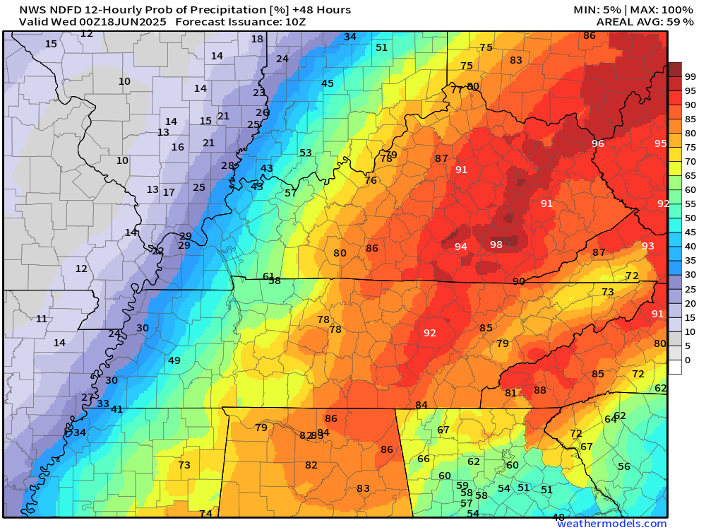
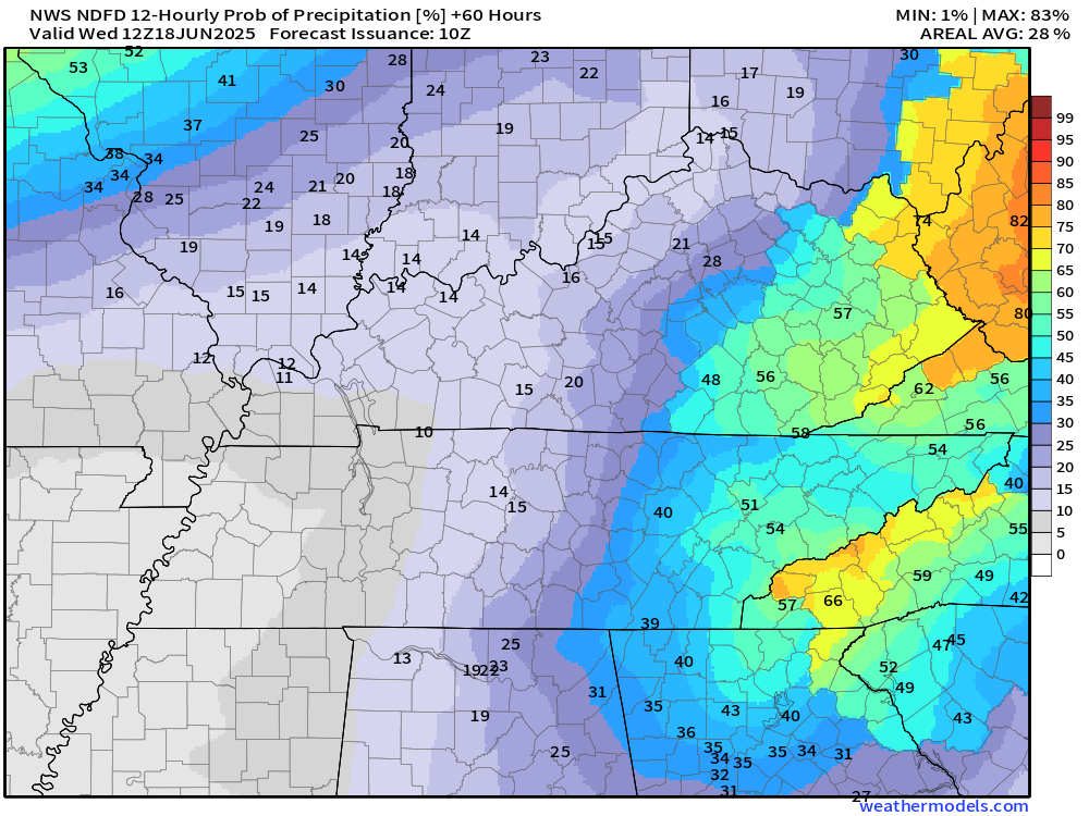
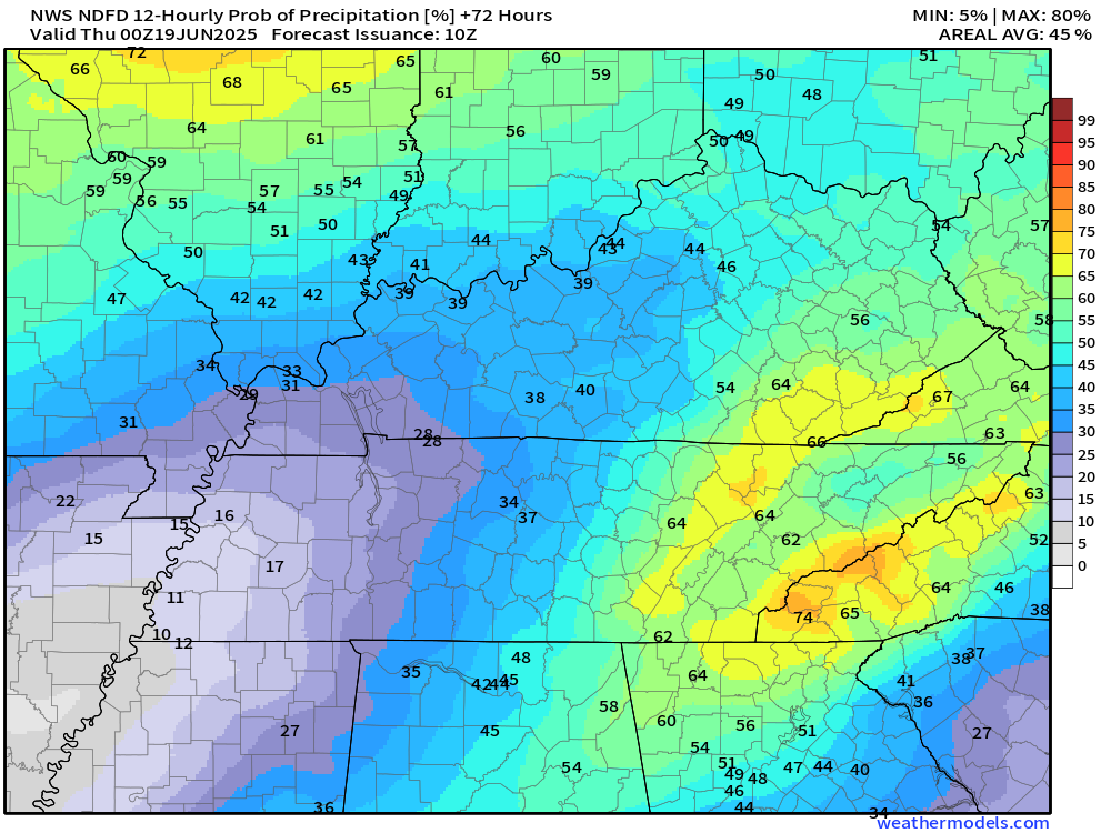
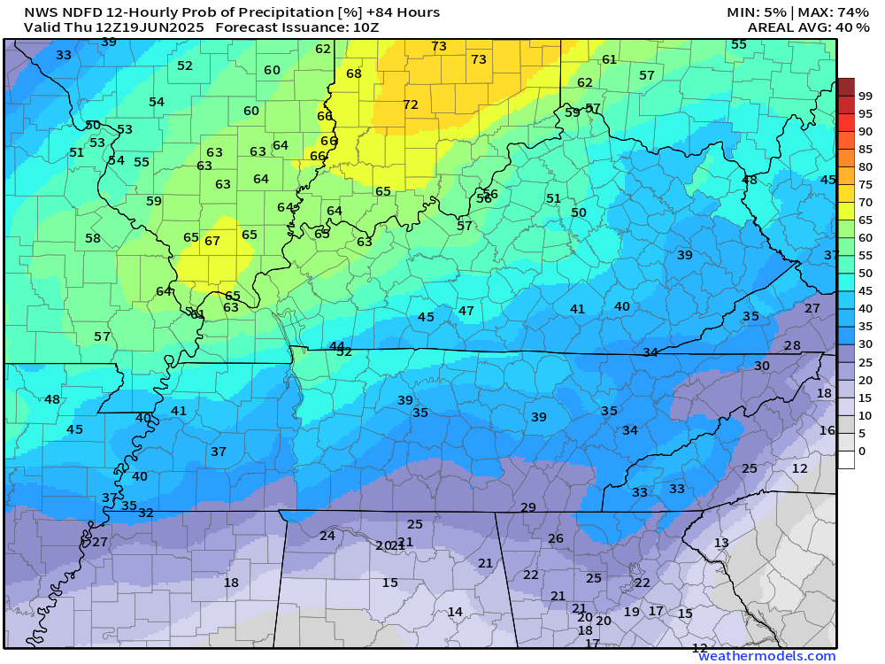
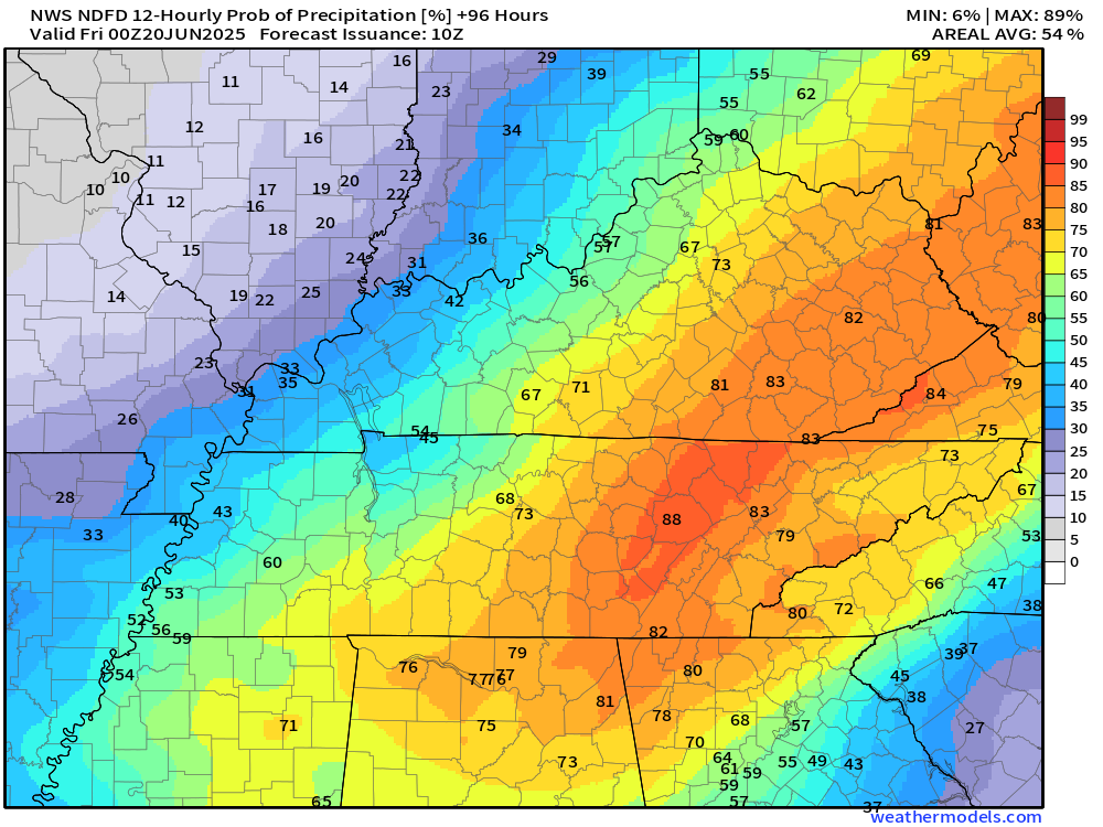
Let’s examine the guidance rainfall probabilities.
What is the rainfall probability for each 12 hour period (day and night).
This will give you a general idea for planning purposes.
Monday (7 AM to 7 PM)
.
Monday night (7 pm to 7 AM)
.
Tuesday (7 AM to 7 PM)
.
Tuesday night (7 PM to 7 AM)
.
Wednedsay (7 AM to 7 PM)
.
Wednesday night (7 PM to 7 AM)
.
Thursday (7 AM to 7 PM)
.

The timestamp (upper left) is in Zulu. 12z=7 am. 18z=1 pm. 00z=7 pm.
Double-click the animation to enlarge it.
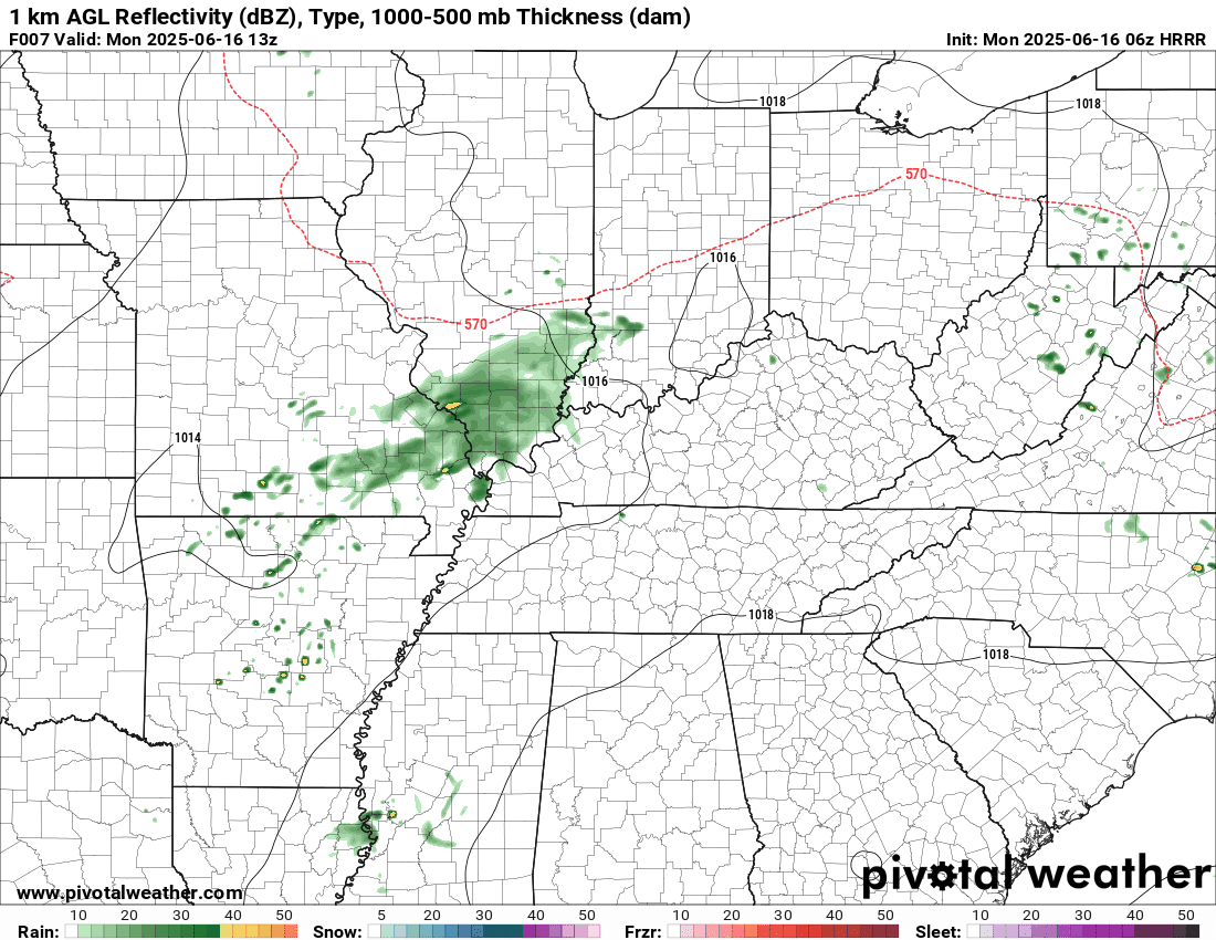
Hrrr model
.
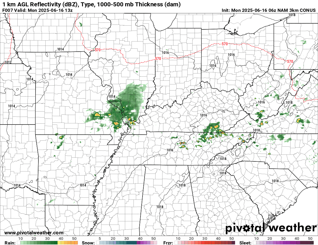
NAM 3K model..
The timestamp (upper left) is in Zulu. 12z=7 am. 18z=1 pm. 00z=7 pm.
..
.
Click here if you would like to return to the top of the page.
.Average high temperatures for this time of the year are around 83 degrees.
Average low temperatures for this time of the year are around 62 degrees.
Average precipitation during this time period ranges from 1.00″ to 1.40″
Six to Ten Day Outlook.
Blue is below average. Red is above average. The no color zone represents equal chances.
Average highs for this time of the year are in the lower 60s. Average lows for this time of the year are in the lower 40s.

Green is above average precipitation. Yellow and brown favors below average precipitation. Average precipitation for this time of the year is around one inch per week.

.

Average low temperatures for this time of the year are around 63 degrees.
Average precipitation during this time period ranges from 1.20″ to 1.50″
.
Eight to Fourteen Day Outlook.
Blue is below average. Red is above average. The no color zone represents equal chances.

Green is above average precipitation. Yellow and brown favors below average precipitation. Average precipitation for this time of the year is around one inch per week.

.
.
.
We have a new service to complement your www.weathertalk.com subscription. This does NOTreplace www.weathertalk.com It is simply another tool for you to receive severe weather information.
.


.

Radars and Lightning Data
Interactive-city-view radars. Clickable watches and warnings.
https://wtalk.co/B3XHASFZ
Old legacy radar site (some of you like it better)
https://weatherobservatory.com/weather-radar.htm
If the radar is not updating then try another one. If a radar does not appear to be refreshing then hit Ctrl F5. You may also try restarting your browser.
Backup radar site in case the above one is not working.
https://weathertalk.com/morani
Regional Radar
https://imagery.weathertalk.com/prx/RadarLoop.mp4
** NEW ** Zoom radar with chaser tracking abilities!
ZoomRadar
If the radar is not working, then email me: Email me at beaudodson@usawx.com
.
We do have some sponsors! Check them out.
Roof damage from recent storms? Link – Click here
INTEGRITY ROOFING AND EXTERIORS!
⛈️ Roof or gutter damage from recent storms? Today’s weather is sponsored by Integrity Roofing. Check out their website at this link https://www.ourintegritymatters.com/

![]()
![]()
![]()
Make sure you have three to five ways of receiving your severe weather information.
Weather Talk is one of those ways! Now, I have another product for you and your family.

.
Want to add more products to your Beau Dodson Weather App?
Receive daily videos, weather blog updates on normal weather days and severe weather and winter storm days, your county by county weather forecast, and more!
Here is how to do add those additional products to your app notification settings!
Here is a video on how to update your Beau Dodson Weather payment.
The app is for subscribers. Subscribe at www.weathertalk.com/welcome then go to your app store and search for WeatherTalk
Subscribers, PLEASE USE THE APP. ATT and Verizon are not reliable during severe weather. They are delaying text messages.
The app is under WeatherTalk in the app store.

Apple users click here

Android users click here
.
Radars and Lightning Data
Interactive-city-view radars. Clickable watches and warnings.
https://wtalk.co/B3XHASFZ
Old legacy radar site (some of you like it better)
https://weatherobservatory.com/weather-radar.htm
If the radar is not updating then try another one. If a radar does not appear to be refreshing then hit Ctrl F5. You may also try restarting your browser.
Backup radar site in case the above one is not working.
https://weathertalk.com/morani
Regional Radar
https://imagery.weathertalk.com/prx/RadarLoop.mp4
** NEW ** Zoom radar with chaser tracking abilities!
ZoomRadar
Lightning Data (zoom in and out of your local area)
https://wtalk.co/WJ3SN5UZ
Not working? Email me at beaudodson@usawx.com
National map of weather watches and warnings. Click here.
Storm Prediction Center. Click here.
Weather Prediction Center. Click here.
.

Live lightning data: Click here.
Real time lightning data (another one) https://map.blitzortung.org/#5.02/37.95/-86.99
Our new Zoom radar with storm chases
.
.

Interactive GOES R satellite. Track clouds. Click here.
GOES 16 slider tool. Click here.
College of DuPage satellites. Click here
.

Here are the latest local river stage forecast numbers Click Here.
Here are the latest lake stage forecast numbers for Kentucky Lake and Lake Barkley Click Here.
.
.
Find Beau on Facebook! Click the banner.


 .
.