
I am going to try to streamline the blog. Centered on the most important aspects of the forecast.
.

Key Messages
🌡️ Hot and Humid Today.
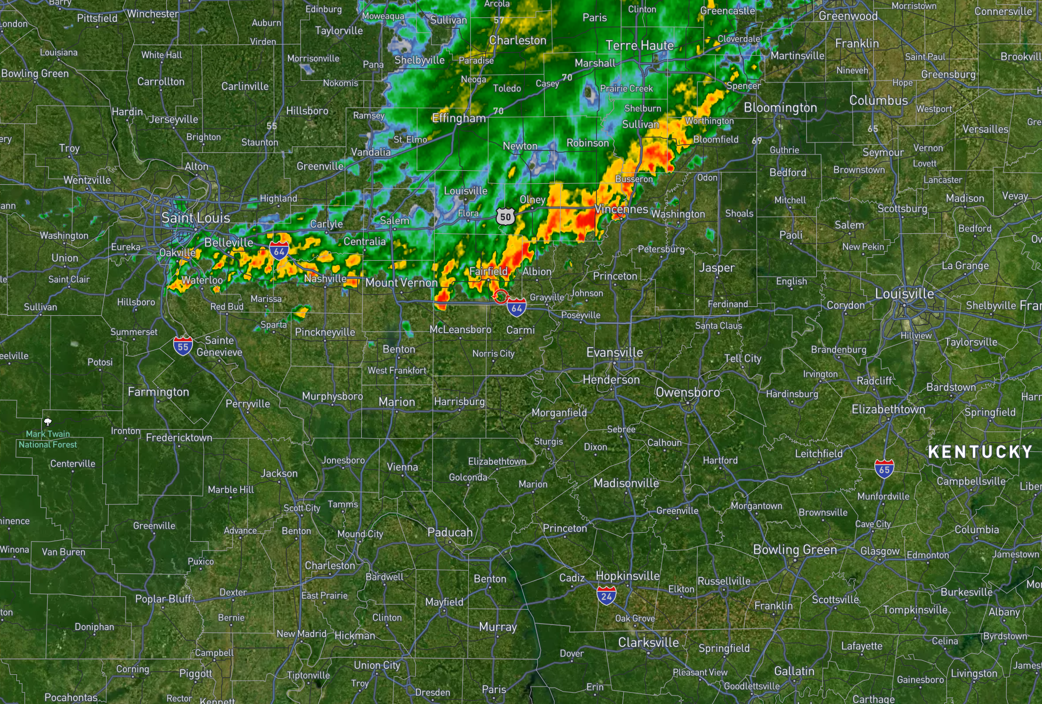
There is a dying line of showers and thunderstorms over my northern counties this morning (5:30 AM). See the radar links below.
Here is what the 5:30 AM radar looked like. This was moving east and a little southeast. It should rapidly weaken this morning.
Double-click images to enlarge them.
Beau Dodson’s Live Weather Radars and Live Lightning Data
Beau’s Weather Radars (local interactive radars)
https://beaudodsonweather.com/weather-radars/
Regional Radar
https://imagery.weathertalk.com/prx/RadarLoop.mp4
Zoom National Interactive Radar
https://wtalk.co/AVWG7GM7
.
Another hot day. A few clouds this morning over my northern counties. Perhaps even a shower early this morning, as well (see above).
You can see those clouds on the 5 AM satellite view. The white area represents clouds (northern counties).
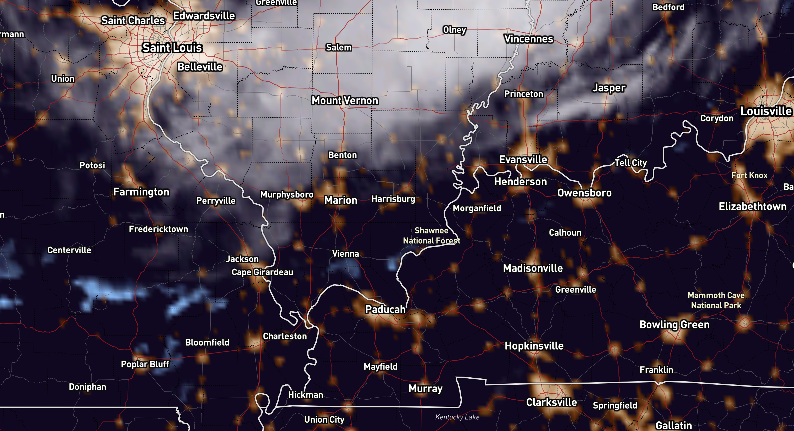
.
⛵ There is a lake wind advisory in effect today. Gusty southerly winds. Boaters use care.
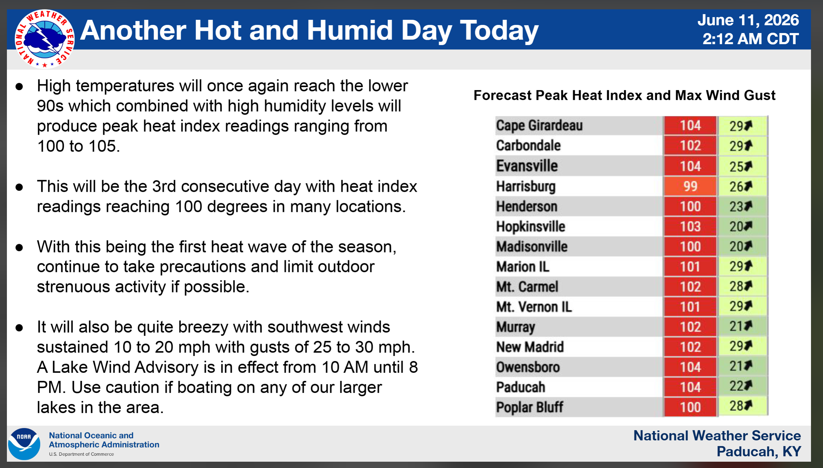
Afternoon temperatures will climb above 90 degrees, and when combined with high humidity, it will feel like 100 to 105 degrees at times!
A little relief is expected on Friday after a cold front moves through. Stay cool. Take breaks if you must work outside, as always.
Here are the anticipated heat index values for this afternoon. Double-click to enlarge this graphic.
.
⛈️ Thunderstorms Return Tonight into Friday Morning
⛵ There is a lake wind advisory in effect today. Winds will gust from the south at over 20 mph. Boaters should use extra care.
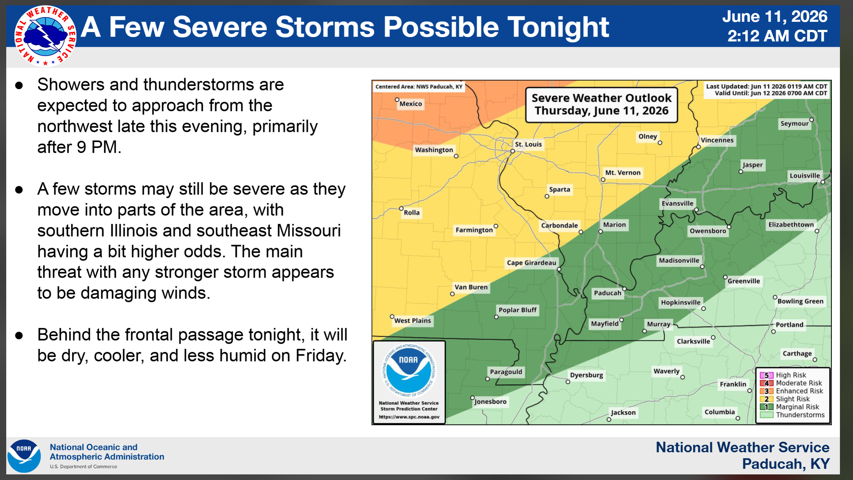
A cold front approaching from the northwest will bring another round of showers and thunderstorms tonight into Friday morning. Some storms could become strong, with strong wind gusts and heavy downpours.
By the time the line reaches extreme southern Illinois, the Missouri Bootheel, western Kentucky, and northwest Tennessee, it should be quite a bit weaker. Some areas farther south could even miss out on the rain altogether. This will depend on just how fast it weakens. See the future-cast radars further down in this weather blog update.
Overall, I am not overly concerned about the risk of severe weather. The line should be dying. There could still be strong winds with the storms. Mainly over southeast Missouri and southern Illinois. Especially the northern portions of those areas.
Perhaps a warning or two if the line holds together a bit more than anticipated. As always, monitor your Beau Dodson Weather App for alerts. I will send out an update or two later today.
Here is the current severe weather outlook for tonight. The yellow zone is a level two out of five severe weather risk. The dark green is the level one out of five threat zone. The scale ranges from one (low) to five (highest).
The light green is where storms are possible but likely to remain below severe limits.
Again, I am not overly concerned at this point.
.
Friday will feel much more comfortable as cooler, drier air moves into the region and humidity levels drop.
.
🌧️ Wet Pattern Returns Later This Weekend
Humid conditions return Saturday afternoon and may continue into Sunday. Another round of showers and thunderstorms is likely Saturday into Saturday night, with some rain possibly lingering through part of Sunday. A few stronger storms could bring heavy rainfall and localized flash flooding.
.
🌤️ Looking Ahead
A few showers may remain on Monday. Chances will be diminishing.
Dry Monday night through Wednesday.
Early next week is expected to be cooler and less humid. There is a 70 to 90 percent chance that dew points stay below 60 degrees on Monday and Tuesday, making it feel much more comfortable. However, warmer and more humid weather is expected to return later next week.
Dew points are what make it feel muggy outside. Dew points in the 50s would feel amazing for this time of the year.
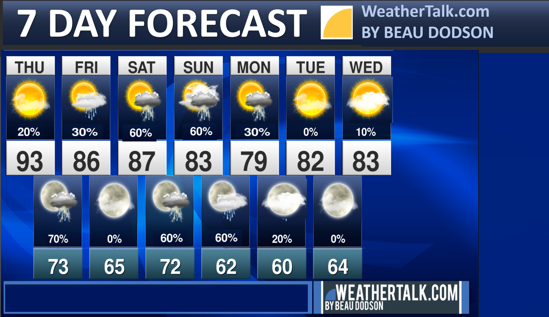
Forecast at a Glance
Today
- A few clouds this morning and perhaps even a shower over my far northern counties.
- Hot and humid
- Highs above 90°
- Heat index 100–105° 🌡️
⛈️ Thursday Night & Early Friday Morning
- Shower and thunderstorm chances increase tonight. And then they will diminish from northwest to southeast on Friday morning.
- Some storms could be strong tonight.
- Gusty winds and heavy rain are possible. Lightning, of course.
Friday morning through Saturday morning
- Drier conditions are anticipated during this time period.
- A bit less muggy. A bit cooler.
Saturday Afternoon Through Monday
- Humidity returns.
- Multiple chances for showers and thunderstorms.
- Heavy rainfall and localized flooding possible. Mainly on Saturday afternoon into Sunday.
Monday night through Wednesday
Nicer conditions. A bit cooler and less humid.
.

.

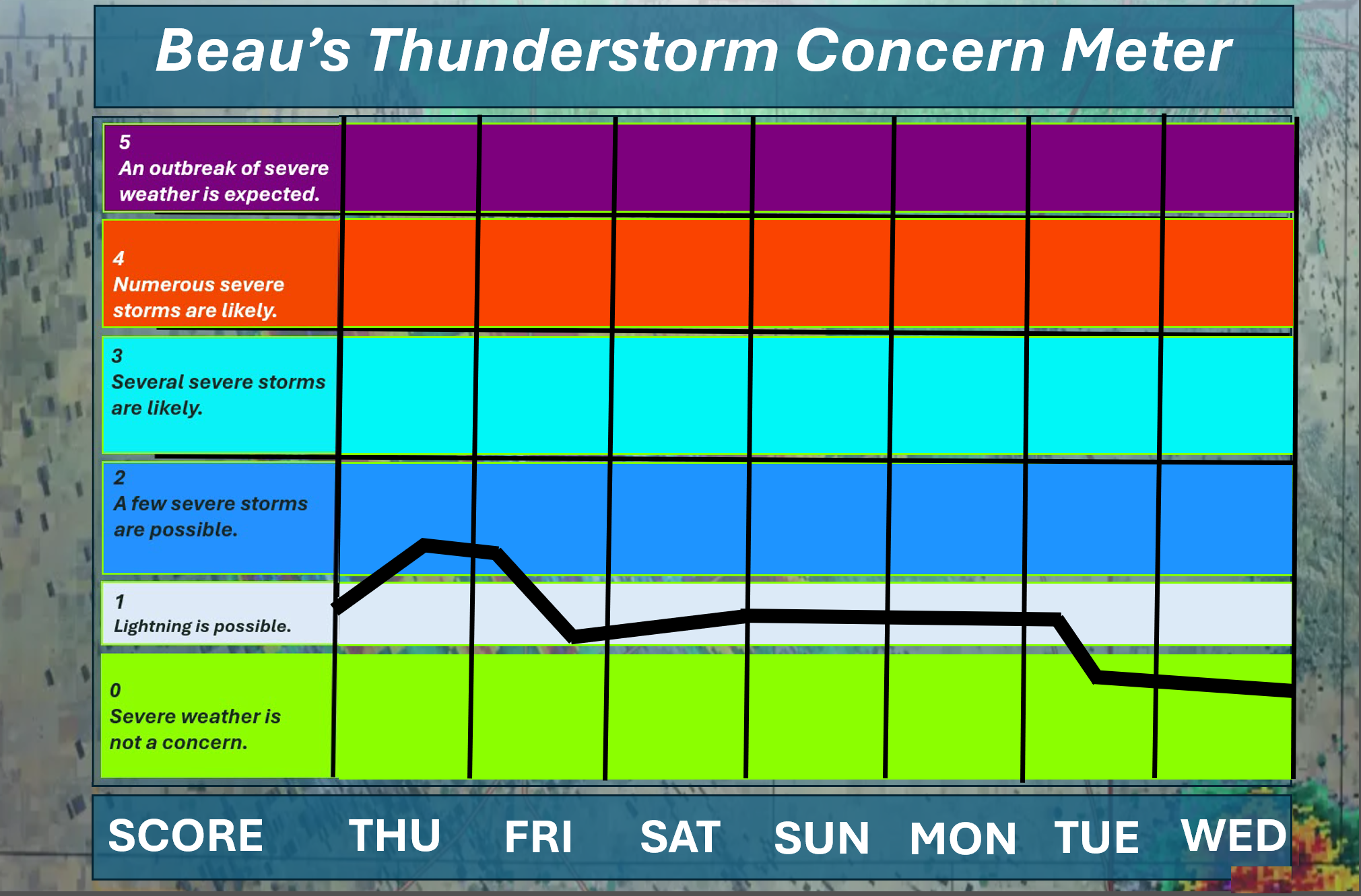
🌪️ Seven-Day Tornado and Severe Weather Outlook ⛈️
June 11th through June 17th
A severe thunderstorm is defined as a storm that produces 58 mph wind gusts and quarter-sized hail or larger.
Current severe weather risk: LOW RISK, OVERALL. I am monitoring tonight’s thunderstorms. I am mainly watching the northern portions of southeast Missouri and the northern portions of southern Illinois. I will keep an eye on trends. A line of storms will approach from the north northwest and move southeast. That line of storms should be weakening as it moves across the region. Monitor updates.
I am also monitoring Saturday afternoon through Sunday. Some of the thunderstorms could produce strong and gusty winds, heavy rain, and frequent lightning. I can’t rule out a few severe thunderstorm warnings.
Here is my thunderstorm concern meter.
.
Current tornado risk: NOT ANTICIPATED. Tornadoes are not anticipated at this time.
Current confidence level in the tornado forecast: Medium.
.

Seven-Day Hazardous Weather Outlook
1. Is lightning in the forecast? YES. A chance of lightning tonight into early next week. Peak chances will be tonight. Most of Friday and Friday night will be lightning-free (low chance). Another peak on Saturday afternoon through Sunday night. Scattered lightning on Monday.
2. Is significant or widespread flash flooding in the forecast? ISOLATED ISSUES. Widespread issues are currently not anticipated.
I will monitor tonight’s thunderstorms. Locally heavy rain could occur where the storms track. Additional locally heavy rain arrives on Saturday and Sunday.
Some localized issues are possible. Areas where thunderstorms repeatedly train over the same area could experience issues.
3. Will non-thunderstorm winds top 40 mph? NO.
4. Will the temperature rise above 90 degrees? YES. A chance of 90 degrees today. Areas with clouds may be a bit lower.
5. Is the heat index forecast to rise above 100 degrees? POSSIBLE. Today. Heat index values will reach the upper nineties and possibly exceed 100 degrees. Areas with clouds may be a bit lower.
6. Is the heat index forecast to rise above 110 degrees? NO.
Your body responds to the heat index. The heat index is more important than the actual temperature. More information about the heat index: Click here.
.


.
Seven-day outlook graphic.
This is a broad-brush overview of the entire region.
* Scroll down to see your local city rain probability maps.
.

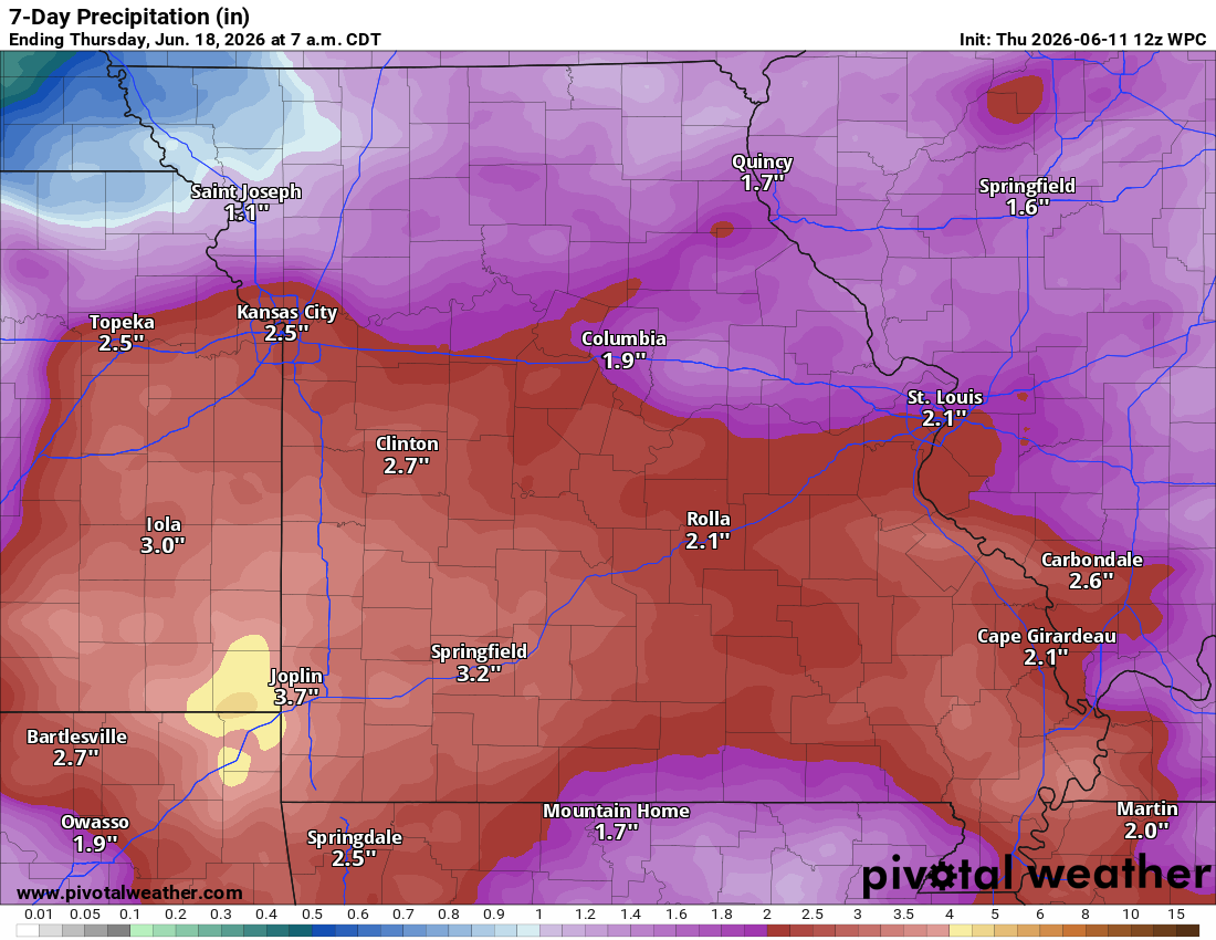
Let’s Look At The Seven-Day Rainfall Totals Forecast
General rainfall total maps for today through next Tuesday morning. This will mainly occur from tonight into Monday afternoon.
* As is typical for late spring, totals will vary greatly. Thunderstorms can double your rainfall totals. Keep that in mind.
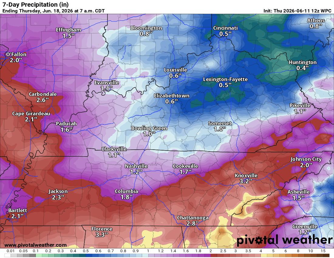
Western view (Missouri and southwest Illinois)
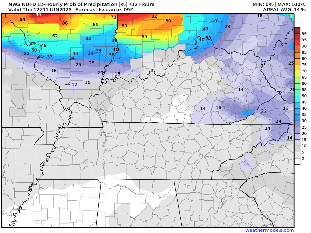
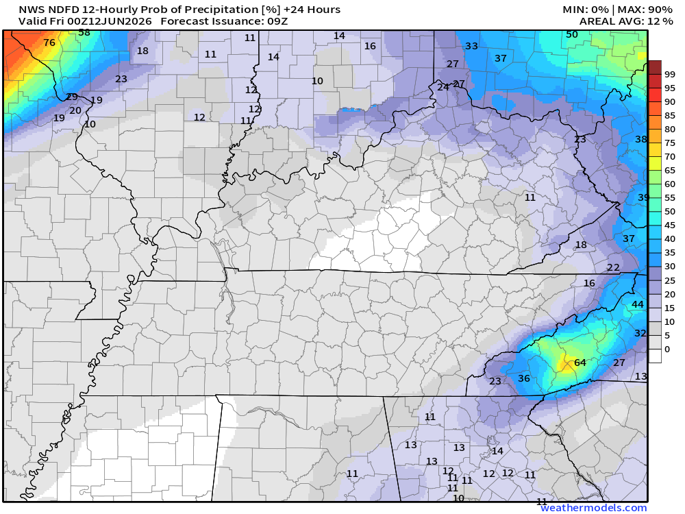
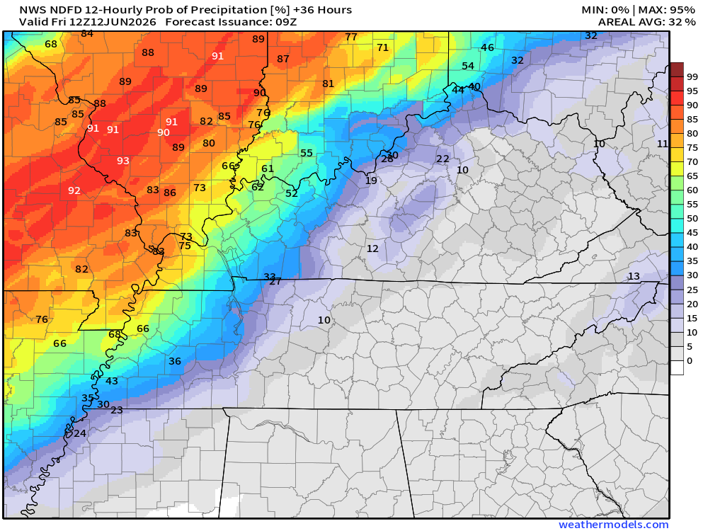
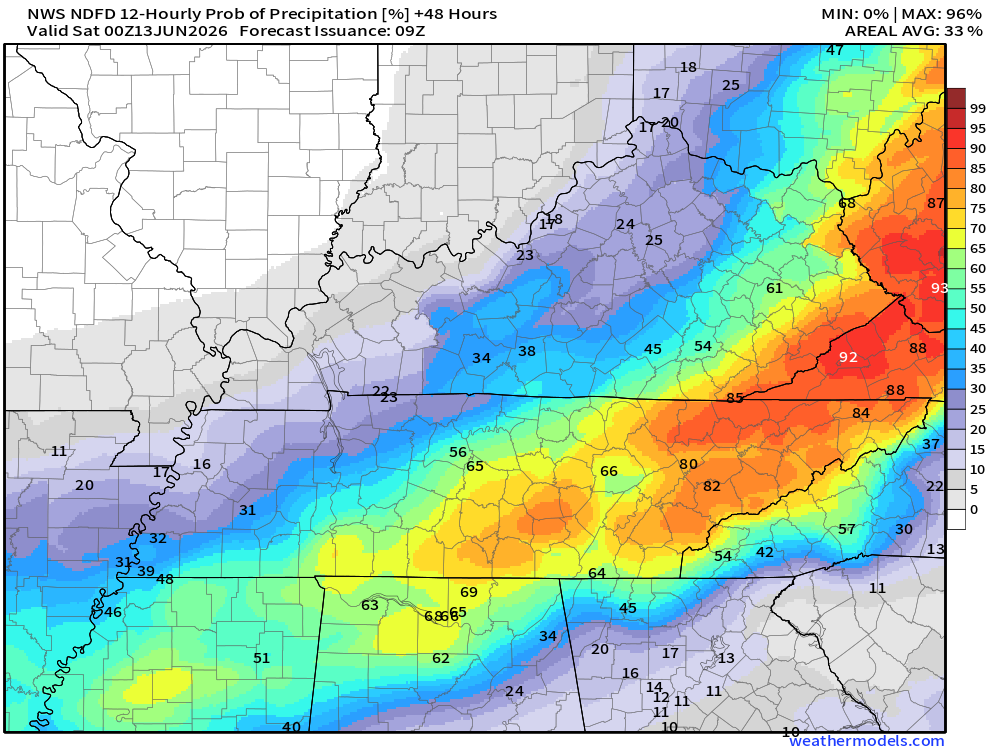
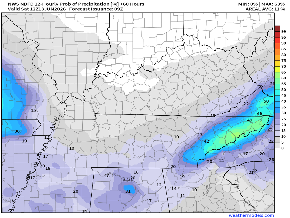
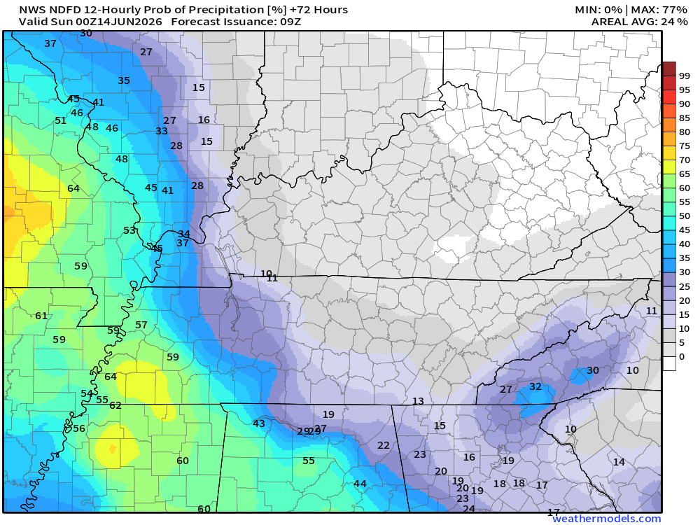
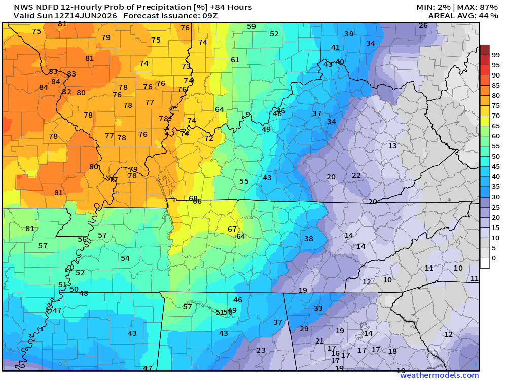
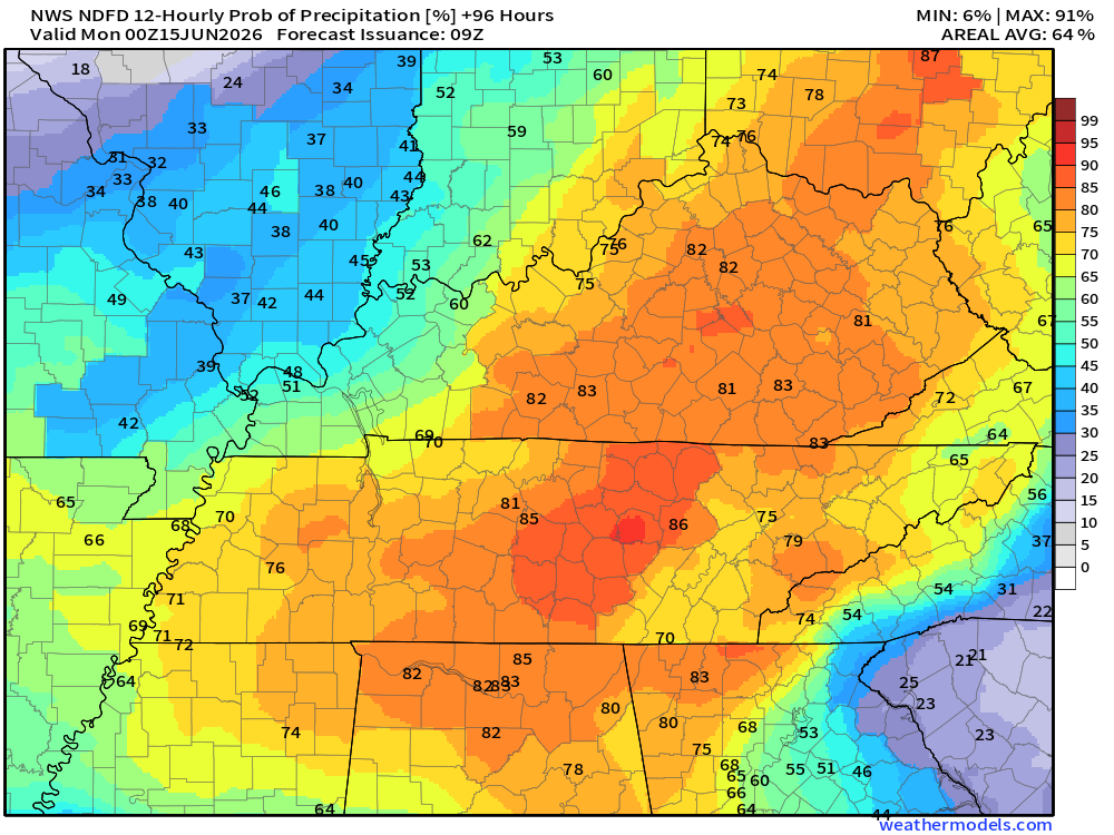
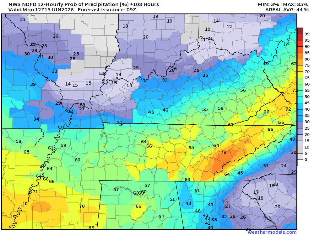
Let’s look at the five-day rain probability maps. What is the % chance of rain?
These maps are broken down into 12-hour time periods.
* Remember, a 20% chance of rain during the summer months does not mean that it will not rain. It means there will be a few thunderstorms on the radar.
Double-click maps to enlarge them.
.

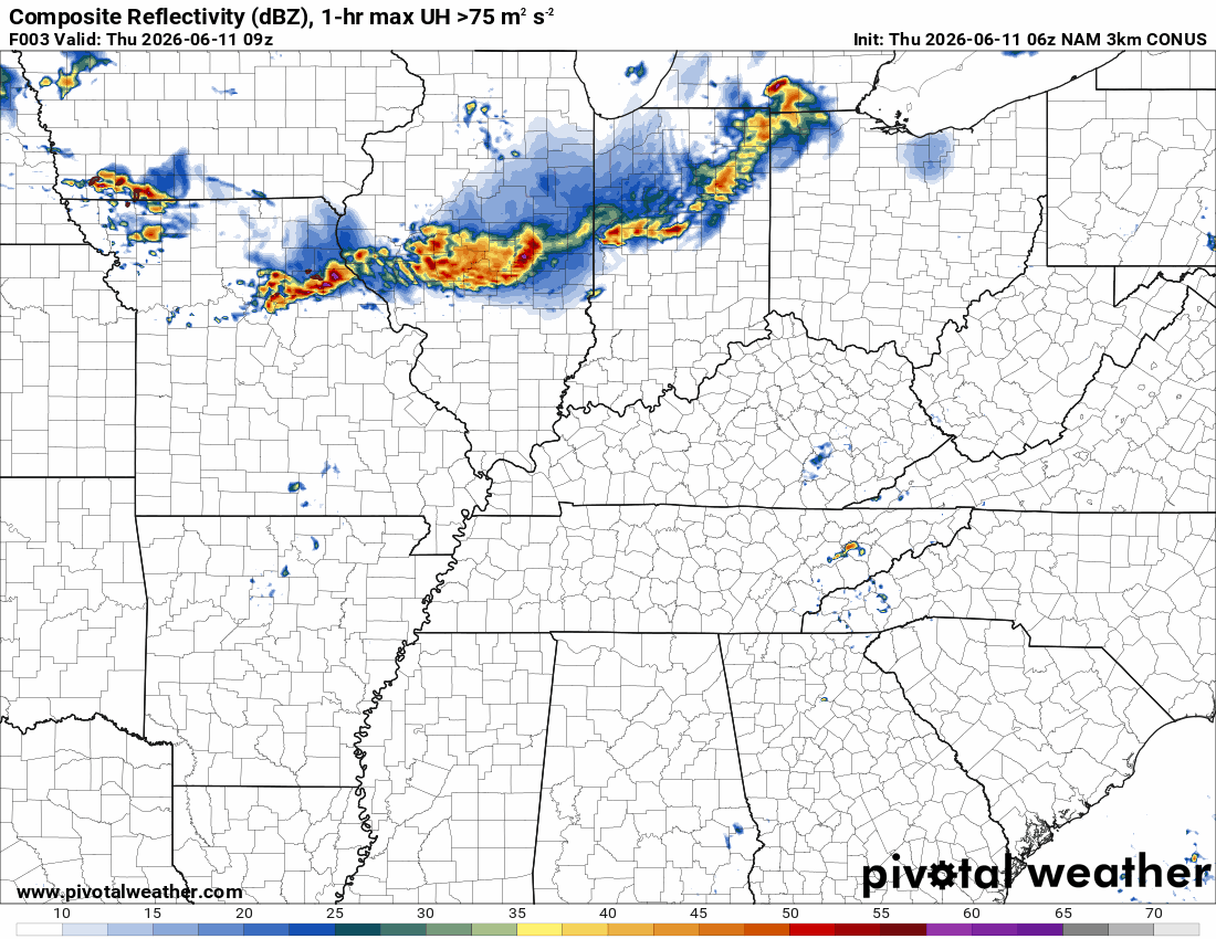
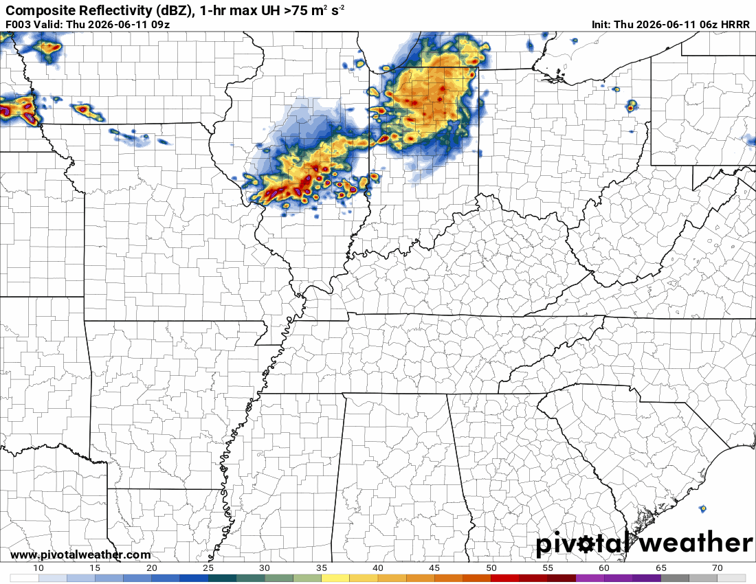
Green is rain. Yellow is moderate rain. Orange indicates locally heavy rain.
Double-click the animation to enlarge it.
![]()
* Future-cast radars are rarely exactly right. Take the general idea from this animation. These models do their best to forecast where precipitation will develop and move. In the end, they are a model.
The timestamp (upper left) is in Zulu. 12z=7 am. 18z=1 pm. 00z=7 pm.
NAM 3K Model
.
Hrrr
..
.
Click here if you would like to return to the top of the page.
.Average high temperatures for this time of the year are around 86 degrees.
Average low temperatures for this time of the year are around 65 degrees.
Average precipitation during this time period ranges from 1.00″ to 1.20″
Six to Ten Day Outlook.
Blue is below average. Red is above average. The no color zone represents equal chances.
Average highs for this time of the year are in the lower 60s. Average lows for this time of the year are in the lower 40s.

Green is above average precipitation. Yellow and brown favors below-average precipitation. Average precipitation for this time of the year is around one inch per week.

.

Live Radars and Lightning Data
Interactive-city-view radars. Clickable watches and warnings.
https://wtalk.co/B3XHASFZ
Regional Radar
https://imagery.weathertalk.com/prx/RadarLoop.mp4
** NEW ** Zoom radar with chaser tracking abilities!
ZoomRadar
Lightning Data (zoom in and out of your local area)
https://wtalk.co/WJ3SN5UZ
.

Average low temperatures for this time of the year are around 65 degrees.
Average precipitation during this time period ranges from 1.00″ to 1.30″
.
Eight to Fourteen Day Outlook.
Blue is below average. Red is above average. The no color zone represents equal chances.

Green is above average precipitation. Yellow and brown favors below average precipitation. Average precipitation for this time of the year is around one inch per week.

.
Radars and Lightning Data
Interactive-city-view radars. Clickable watches and warnings.
https://wtalk.co/B3XHASFZ
Old legacy radar site (some of you like it better)
https://weatherobservatory.com/weather-radar.htm
If the radar is not updating then try another one. If a radar does not appear to be refreshing then hit Ctrl F5. You may also try restarting your browser.
Backup radar site in case the above one is not working.
https://weathertalk.com/morani
Regional Radar
https://imagery.weathertalk.com/prx/RadarLoop.mp4
** NEW ** Zoom radar with chaser tracking abilities!
ZoomRadar
Lightning Data (zoom in and out of your local area)
https://wtalk.co/WJ3SN5UZ
Not working? Email me at beaudodson@usawx.com

Live lightning data: Click here.
Real time lightning data (another one) https://map.blitzortung.org/#5.02/37.95/-86.99
.
.
We have a new service to complement your www.weathertalk.com subscription. This does NOT replace www.weathertalk.com It is simply another tool for you to receive severe weather information.
.
https://weathercallservices.com/beau-dodson-weather


Want to receive the daily forecast/other products on your Beau Dodson Weather app?
Did you know you have four options in your www.weathertalk.com account
You will then receive these via your Beau Dodson Weather app.
Just log into your www.weathertalk.com account
Click the NOTIFICATION SETTINGS TAB
Then, turn them on (green) and off (red)
🌪️ Number 1 is the most important one. Severe alerts, tornado alerts, and so on.
Number 2 is the daily video, blog, livestream alerts, and severe weather Facebook threads on severe days or winter storm days.
Number 3 is the daily forecast. I send that out every day during the afternoon hours. It is the seven-day forecast, hazardous weather outlook, fire outlook, and more.
Number 4 is to receive the daily video, blog, and other content on NON-severe weather days (every day without severe threats in other words)
GREEN IS ON
RED IS OFF

Want to add more products to your Beau Dodson Weather App?
Receive daily videos, weather blog updates on normal weather days and severe weather and winter storm days, your county by county weather forecast, and more!
Here is how to do add those additional products to your app notification settings!
The app is for subscribers. Subscribe at www.weathertalk.com/welcome then go to your app store and search for WeatherTalk
Subscribers, PLEASE USE THE APP. ATT and Verizon are not reliable during severe weather. They are delaying text messages.
The app is under WeatherTalk in the app store.

Apple users click here

Android users click here