.
Click one of the links below to take you directly to that section.
Do you have any suggestions or comments? Email me at beaudodson@usawx.com
.
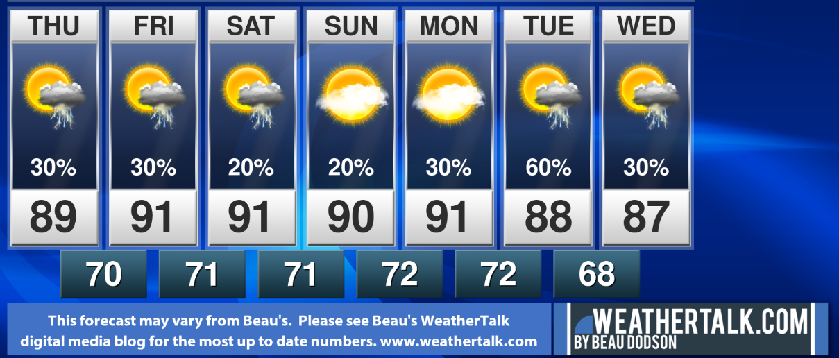
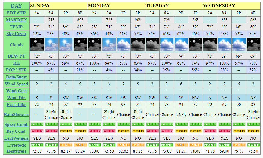
7-day forecast for southeast Missouri, southern Illinois, western Kentucky, and western Tennessee.
This is a blend for the region. See the detailed region by region forecast further down in this post.
.


.

.
Thursday through Thursday.
1. Is lightning in the forecast? Yes. Daily chances.
2. Are severe thunderstorms in the forecast? Lower end risk. Typical summer thunderstorms. Down-burst wind will be the primary concern. If a thunderstorm line or complex forms then damaging wind chances will increase.
* The NWS officially defines a severe thunderstorm as a storm with 58 mph wind or greater, 1″ hail or larger, and/or tornadoes
3. Is flash flooding in the forecast? Yes. Slow moving storms will produce heavy rain. Pockets of flash flooding may occur.
4. Will there be a chance of a frost or freeze? No.
5. Will the heat index exceed 100 degrees? Yes. Heat index values from 100 to 105 (locally higher) are likely outside of cloudy areas. These numbers will mainly be Saturday and Sunday. Otherwise, mid to upper 90s today through Friday.
..
.
July 23, 2020
How confident am I that this days forecast will verify? High confidence
Thursday Forecast: Partly cloudy. A chance of thunderstorms developing. Hot and humid.
What is the chance of precipitation? MO ~ 30% to 40% IL ~ 40% KY ~ 40% TN ~ 30%
Temperature range: MO Bootheel 90° to 94° SE MO 88° to 92° South IL 88° to 92° Northwest KY (near Indiana border) 88° to 92° West KY 88° to 92° NW TN 88° to 92°
Wind direction and speed: South and southwest at 5 to 10 mph
Wind chill or heat index (feels like) temperature forecast: 95° to 100°
Coverage of precipitation: Scattered to perhaps numerous
What impacts are anticipated from the weather? Heat. Wet roadways and lightning, Locally heavy rain could cause some brief flash flooding. Isolated wind damage. Gusty wind near storms. High heat index values. Use care.
Should I cancel my outdoor plans? No, but monitor updates and radars
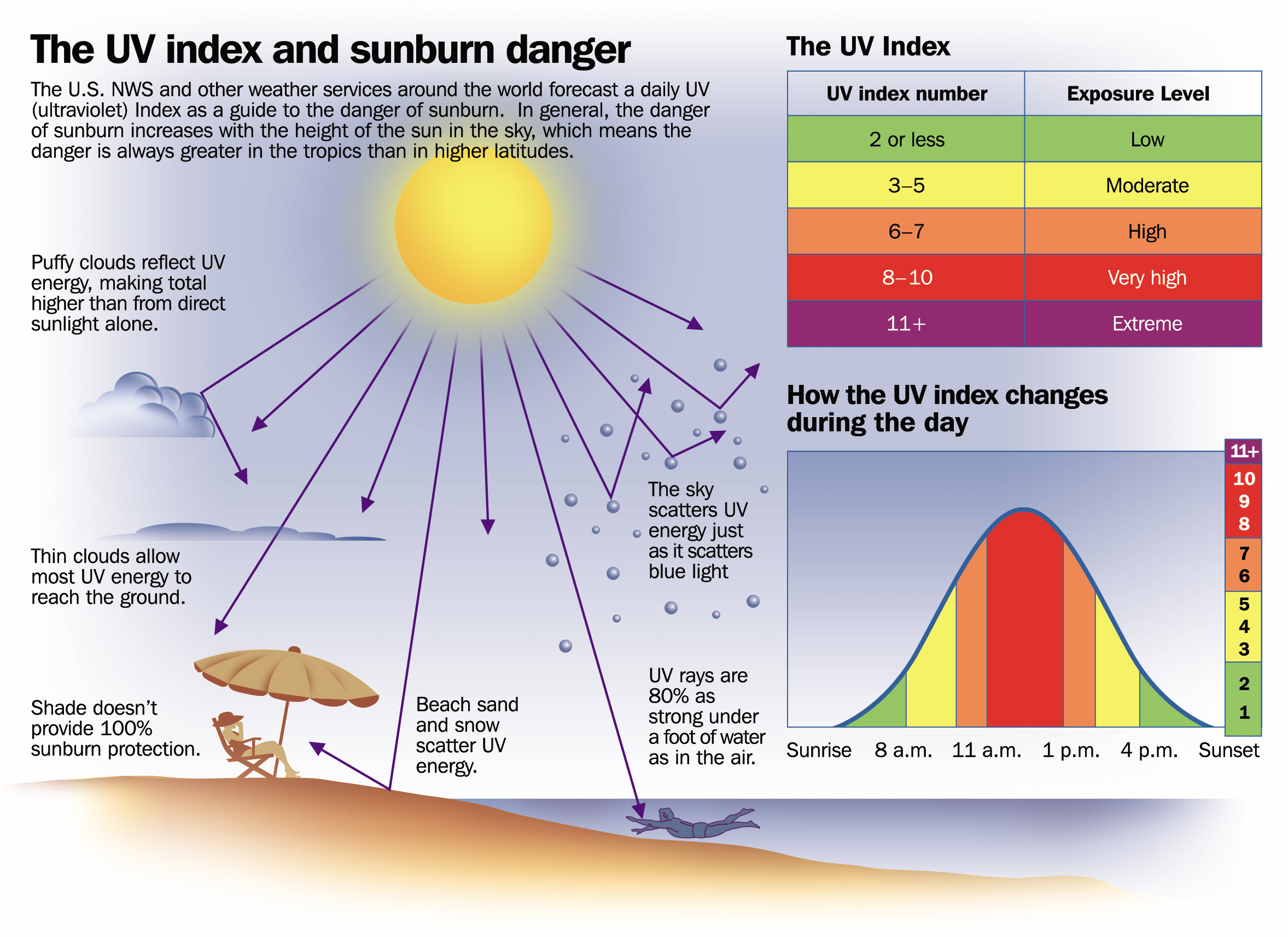
UV Index: 11. Very high.
Sunrise: 5:53 AM
Sunset: 8:10 PM
.
Thursday night Forecast: Partly cloudy. A slight chance of thunderstorms.
What is the chance of precipitation? MO ~ 20% IL ~ 20% KY ~ 20% TN ~ 20%
Temperature range: MO Bootheel 70° to 72° MO 70° to 72° South IL 68° to 72° Northwest KY (near Indiana border) 70° to 72° West KY 70° to 72° NW TN 70° to 74°
Wind direction and speed: Light wind
Wind chill or heat index (feels like) temperature forecast: 68° to 74°
Coverage of precipitation: Isolated
What impacts are anticipated from the weather? Wet roadways. Lightning. Heavy rain where thunderstorms occur.
Should I cancel my outdoor plans? No, but monitor updates and radars
Moonrise: 8:56 AM
Moonset: 10:35 PM
The phase of the moon: Waxing Crescent
.
July 24, 2020
How confident am I that this days forecast will verify? High confidence
Friday Forecast: Partly to mostly sunny. Scattered thunderstorms. Hot and humid.
What is the chance of precipitation? MO ~ 30% IL ~ 40% KY ~ 40% TN ~ 30%
Temperature range: MO Bootheel 88° to 92° SE MO 88° to 92° South IL 88° to 92° Northwest KY (near Indiana border) 88° to 92° West KY 88° to 92° NW TN 88° to 92°
Wind direction and speed: Light south wind
Wind chill or heat index (feels like) temperature forecast: 95° to 100°
Coverage of precipitation: Scattered
What impacts are anticipated from the weather? Heat. Wet roadways and lightning, Locally heavy rain could cause some brief flash flooding. Isolated wind damage. Gusty wind near storms. High heat index values. Use care.
Should I cancel my outdoor plans? No, but monitor updates and radars
UV Index: 11. Very high.
Sunrise: 5:53 AM
Sunset: 8:10 PM
.
Friday night Forecast: Partly cloudy. An isolated thunderstorm. Warm. Humid.
What is the chance of precipitation? MO ~ 20% IL ~ 20% KY ~ 20% TN ~ 20%
Temperature range: MO Bootheel 72° to 75° MO 72° to 75° South IL 72° to 74° Northwest KY (near Indiana border) 72° to 74° West KY 72° to 74° NW TN 72° to 75°
Wind direction and speed: Southeast at 3 to 6 mph
Wind chill or heat index (feels like) temperature forecast: 70° to 75°
Coverage of precipitation: Isolated
What impacts are anticipated from the weather? Humid. Wet roadways. Lightning. Heavy rain where thunderstorms occur.
Should I cancel my outdoor plans? No, but monitor updates and radars
Moonrise: 10:07 AM
Moonset: 11:07 PM
The phase of the moon: Waxing Crescent
.
July 25, 2020
How confident am I that this days forecast will verify? High confidence
Saturday Forecast: Mostly sunny. Hot and muggy. Isolated thunderstorms.
What is the chance of precipitation? MO ~ 20% IL ~ 20% KY ~ 20% TN ~ 20%
Temperature range: MO Bootheel 90° to 94° SE MO 90° to 94° South IL 88° to 94° Northwest KY (near Indiana border) 90° to 94° West KY 90° to 94° NW TN 92° to 95°
Wind direction and speed: South at 4 to 8 mph
Wind chill or heat index (feels like) temperature forecast: 98° to 105°
Coverage of precipitation: Isolated
What impacts are anticipated from the weather? Heat. Isolated wet roadways and lightning, Isolated heavy rain could cause some brief flash flooding. Isolated wind damage. Gusty wind near storms. High heat index values. Use care.
Should I cancel my outdoor plans? No, but monitor updates and radars
UV Index: 11. Very high.
Sunrise: 5:54 AM
Sunset: 8:09 PM
.
Saturday night Forecast: A few evening clouds. Clearing. Any evening storms will come to an end. Warm. Humid.
What is the chance of precipitation? MO ~ 10% IL ~ 10% KY ~ 10% TN ~ 10%
Temperature range: MO Bootheel 70° to 75° MO 70° to 74° South IL 70° to 74° Northwest KY (near Indiana border) 70° to 74° West KY 70° to 74° NW TN 70° to 75°
Wind direction and speed: South at 4 to 8 mph
Wind chill or heat index (feels like) temperature forecast: 70° to 75°
Coverage of precipitation: Isolated
What impacts are anticipated from the weather? Humid. Isolated wet roadways. Isolated lightning.
Should I cancel my outdoor plans? No, but monitor updates and radars
Moonrise: 11:16 AM
Moonset: 11:38 PM
The phase of the moon: Waxing Crescent
.
July 26, 2020
How confident am I that this days forecast will verify? High confidence
Sunday Forecast: Mostly sunny. Isolated thunderstorms. Hot and humid.
What is the chance of precipitation? MO ~ 20% IL ~ 20% KY ~ 20% TN ~ 20%
Temperature range: MO Bootheel 90° to 94° SE MO 90° to 94° South IL 90° to 94° Northwest KY (near Indiana border) 90° to 94° West KY 90° to 94° NW TN 92° to 95°
Wind direction and speed: South at 5 to 10 mph
Wind chill or heat index (feels like) temperature forecast: 100° to 105°
Coverage of precipitation: Isolated
What impacts are anticipated from the weather? Heat. Isolated wet roadways and lightning. High heat index values. Use care.
Should I cancel my outdoor plans? No, but monitor updates and radars
UV Index: 11. Very high.
Sunrise: 5:55 AM
Sunset: 8:08 PM
.
Sunday night Forecast: Mostly clear. Warm and muggy. A slight chance of thunderstorms.
What is the chance of precipitation? MO ~ 20% IL ~ 20% KY ~ 20% TN ~ 20%
Temperature range: MO Bootheel 73° to 76° MO 73° to 76° South IL 73° to 76° Northwest KY (near Indiana border) 73° to 76° West KY 73° to 76° NW TN 73° to 76°
Wind direction and speed: South at 4 to 8 mph
Wind chill or heat index (feels like) temperature forecast: 73° to 76°
Coverage of precipitation: Isolated
What impacts are anticipated from the weather? Isolated wet roadways and lightning.
Should I cancel my outdoor plans? No, but monitor updates and radars
Moonrise: 12:26 PM
Moonset: 12:01 AM
The phase of the moon: Waxing Crescent
.
July 27, 2020
How confident am I that this days forecast will verify? Medium confidence
Monday Forecast: Mostly sunny. Widely scattered thunderstorms. Hot and humid.
What is the chance of precipitation? MO ~ 30% IL ~ 30% KY ~ 20% TN ~ 20%
Temperature range: MO Bootheel 90° to 94° SE MO 90° to 94° South IL 90° to 94° Northwest KY (near Indiana border) 90° to 94° West KY 90° to 94° NW TN 92° to 95°
Wind direction and speed: South at 5 to 10 mph
Wind chill or heat index (feels like) temperature forecast: 98° to 104°
Coverage of precipitation: Widely scattered
What impacts are anticipated from the weather? Heat. Wet roadways and lightning, Locally heavy rain could cause some brief flash flooding. Isolated wind damage. Gusty wind near storms. High heat index values. Use care.
Should I cancel my outdoor plans? No, but monitor updates and radars
UV Index: 11. Very high.
Sunrise: 5:56 AM
Sunset: 8:07 PM
.
Monday night Forecast: Partly cloudy. Isolated thunderstorms. Warm and humid.
What is the chance of precipitation? MO ~ 20% IL ~ 20% KY ~ 20% TN ~ 20%
Temperature range: MO Bootheel 73° to 76° MO 72° to 74° South IL 72° to 74° Northwest KY (near Indiana border) 72° to 74° West KY 73° to 76° NW TN 73° to 76°
Wind direction and speed: Southwest at 4 to 8 mph
Wind chill or heat index (feels like) temperature forecast: 70° to 75°
Coverage of precipitation: Isolated
What impacts are anticipated from the weather? Humid. Wet roadways. Lightning. Heavy rain where thunderstorms occur.
Should I cancel my outdoor plans? No, but monitor updates and radars
Moonrise: 1:34 PM
Moonset: 12:10 AM
The phase of the moon: First Quarter
.
July 28, 2020
How confident am I that this days forecast will verify? Medium confidence
Tuesday Forecast: Partly sunny. Thunderstorms developing.
What is the chance of precipitation? MO ~ 50% IL ~ 50% KY ~ 50% TN ~ 50%
Temperature range: MO Bootheel 88° to 92° SE MO 88° to 92° South IL 88° to 92° Northwest KY (near Indiana border) 88° to 92° West KY 88° to 92° NW TN 88° to 92°
Wind direction and speed: South at 5 to 10 mph
Wind chill or heat index (feels like) temperature forecast: 88° to 94°
Coverage of precipitation: Scattered to numerous
What impacts are anticipated from the weather? Wet roadways and lightning, Locally heavy rain could cause some brief flash flooding. Isolated wind damage. Gusty wind near storms.
Should I cancel my outdoor plans? No, but monitor updates and radars
UV Index: 10. Very high.
Sunrise: 5:57 AM
Sunset: 8:06 PM
.
Tuesday night Forecast: Mostly cloudy with a chance of thunderstorms.
What is the chance of precipitation? MO ~ 40% IL ~ 40% KY ~ 40% TN ~ 40%
Temperature range: MO Bootheel 68° to 72° MO 66° to 72° South IL 66° to 72° Northwest KY (near Indiana border) 66° to 72° West KY 66° to 72° NW TN 66° to 72°
Wind direction and speed: South at 5 to 10 mph
Wind chill or heat index (feels like) temperature forecast: 66° to 72°
Coverage of precipitation: Scattered
What impacts are anticipated from the weather? Humid. Wet roadways. Lightning. Heavy rain where thunderstorms occur.
Should I cancel my outdoor plans? No, but monitor updates and radars
Moonrise: 2:44 PM
Moonset: 12:43 AM
The phase of the moon: Waxing Gibbous
.
July 29, 2020
How confident am I that this days forecast will verify? Medium confidence
Wednesday Forecast: Partly sunny. Thunderstorms developing. Not as hot.
What is the chance of precipitation? MO ~ 50% IL ~ 50% KY ~ 50% TN ~ 50%
Temperature range: MO Bootheel 84° to 88° SE MO 84° to 88° South IL 84° to 88° Northwest KY (near Indiana border) 84° to 88° West KY 84° to 88° NW TN 84° to 88°
Wind direction and speed: Northwest at 5 to 10 mph
Wind chill or heat index (feels like) temperature forecast: 86° to 92°
Coverage of precipitation: Scattered to numerous
What impacts are anticipated from the weather? Wet roadways and lightning, Locally heavy rain could cause some brief flash flooding. Isolated wind damage. Gusty wind near storms.
Should I cancel my outdoor plans? No, but monitor updates and radars
UV Index: 10. Very high.
Sunrise: 5:57 AM
Sunset: 8:05 PM
.
Wednesday night Forecast: Mostly cloudy with a chance of thunderstorms.
What is the chance of precipitation? MO ~ 40% IL ~ 40% KY ~ 40% TN ~ 40%
Temperature range: MO Bootheel 68° to 72° MO 65° to 70° South IL 65° to 70° Northwest KY (near Indiana border) 65° to 70° West KY 66° to 72° NW TN 66° to 72°
Wind direction and speed: Northwest at 5 mph
Wind chill or heat index (feels like) temperature forecast: 66° to 72°
Coverage of precipitation: Scattered
What impacts are anticipated from the weather? Humid. Wet roadways. Lightning. Heavy rain where thunderstorms occur.
Should I cancel my outdoor plans? No, but monitor updates and radars
Moonrise: 3:53 PM
Moonset: 1:20 AM
The phase of the moon: Waxing Gibbous
.
What is the UV index?
.

.
- Highs in the upper 80s to middle 90s this week. Heat concerns.
- Locally heavy rain will be the primary concern.
.
Click to enlarge the graphics.
Remember, this is an average across our local area. The county by county will vary. See the detailed forecast above for each area.
Click graphics to enlarge them.
.
.
![]()
![]()
Graphic-cast
Click here if you would like to return to the top of the page.
Illinois
During active weather check my handwritten forecast towards the top of the page.

.
Kentucky
During active weather check my handwritten forecast towards the top of the page.


.

.

.
Tennessee
During active weather check my handwritten forecast towards the top of the page.

.
.
Today through July 27th: Scattered summer thunderstorms today. A few storms Friday and then isolated storms Saturday and Sunday.
Thunderstorm chances increase again Monday night through Wednesday. Fingers crossed for those who need rain.
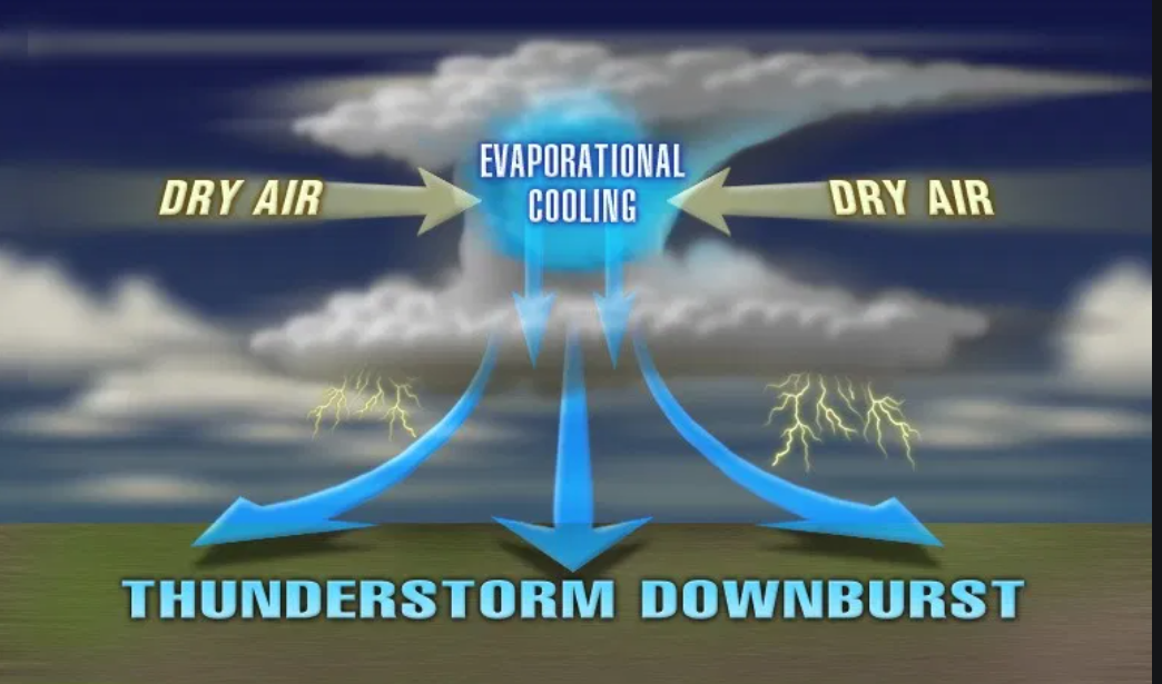
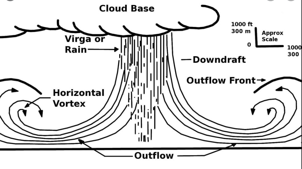
Some of the thunderstorms will produce torrential rain, frequent lightning, strong and gusty wind, and dime size hail. There is a chance of a few damaging wind reports, as well.
Down-burst wind will be the primary concern.
Down-burst winds are not uncommon during July.
Today’s outlook (below).
Light green is where thunderstorms may occur but should be below severe levels.
Dark green is a level one risk. Yellow is a level two risk. Orange is a level three (enhanced) risk. Red is a level four (moderate) risk. Pink is a level five (high) risk.
One is the lowest risk. Five is the highest risk.
A severe storm is one that produces 58 mph wind or higher, quarter size hail, and/or a tornado.
The tan states are simply a region that SPC outlined on this particular map. Just ignore that.

The black outline is our local area.

.
Tomorrow’s severe weather outlook.

.

.
The images below are from the WPC. Their totals are a bit lower than our current forecast. I wanted to show you the comparison.
24-hour precipitation outlook.
.
 .
.
48-hour precipitation outlook.
.
.
72-hour precipitation outlook.
.
![]()

![]()
..
Weather advice:
Updated July 23, 2020
Thunderstorms will produce lightning and heavy rain/strong wind. If you have outdoor plans then you will want to check the weather radars.
Muggy weather. Use care when working outdoors, as always.
Don’t leave pets, children, or adults in hot cars. Cars can rapidly heat to above 115 degrees in this kind of weather. Use common sense, as always.
Download the Beau Dodson Weather Talk app from the app store. Search for Weather Talk by the Fire Horn. Download it. Install it. It is for subscribers. Not a subscriber? Go to www.weathertalk.com/welcome
.
Weather Discussion
-
- Thunderstorm chances.
- Heat and high dew points = muggy air.
- Hot weekend.
- Some good news for next week? Perhaps.
.
No real change to the going forecast discussion.
Another hot and muggy day. Highs in the upper 80s to around 90 with heat index values ranging from 94 to 98 and locally 100 degrees.
Scattered thunderstorms are already dotting radar. That will continue and increase during peak heating hours. Not everyone will see rain today. Same as recent days.
Once again feast or famine. Some locations will pick up a quick one to three+ inches of rain. Other locations will remain dry.
If you have lived in this region for any period of time you will realize that this is how our summers typically unfold.
A few of the thunderstorms could produce isolated damaging wind, as well. Same as recent days.
Flash flooding is likely with the slower moving thunderstorm cells. Frequent cloud to ground lightning, of course. Again, typical summer thunderstorms.
.
Clouds and scattered thunderstorms will make for a difficult temperature forecast. You can shave several degrees off the high temperature where clouds are thicker.
For the most part, highs will top out in the 86 to 92 degree range. Heat index values will range from 95 to 102 today and tomorrow and then pop to 100 to 105 over the weekend.
Speaking of the weekend!
Friday will deliver at least widely scattered thunderstorms. Thunderstorm activity become more and more isolated Friday night through Sunday.
Temperatures will also inch upward over the weekend with widespread actual temperatures in the lower 90s and heat index values of 100 to 105. Locally higher.
Peak heating will be 2 PM through 6 PM. Use care, as always.
Some good news next week? Perhaps.
Guidance indicates a cold front will slip southward into our region Monday night and stall out. That would mean a chance of showers and thunderstorms Monday night into at least Wednesday.
I will keep an eye on the tropical activity in the Gulf of Mexico, as well. That could throw more moisture our way. For now, that is not the forecast. I am simply monitoring it.
Thankfully, if this front does move into our region it will mean somewhat lower temperatures (80s vs 90s) and a chance of more rain. Some of us still need rain.
It would be nice to keep the shower and thunderstorm chances going. We don’t want a flash drought (which some are border-line in already).
Know the signs of heat illness.
.

.
![]()
.
 .
.
Click here if you would like to return to the top of the page.
Again, as a reminder, these are models. They are never 100% accurate. Take the general idea from them.
What should I take from these?
- The general idea and not specifics. Models usually do well with the generalities.
- The time-stamp is located in the upper left corner.
.
What am I looking at?
You are looking at different models. Meteorologists use many different models to forecast the weather. All models are wrong. Some are more wrong than others. Meteorologists have to make a forecast based on the guidance/models.
I show you these so you can see what the different models are showing as far as precipitation. If most of the models agree, then the confidence in the final weather forecast increases.
.
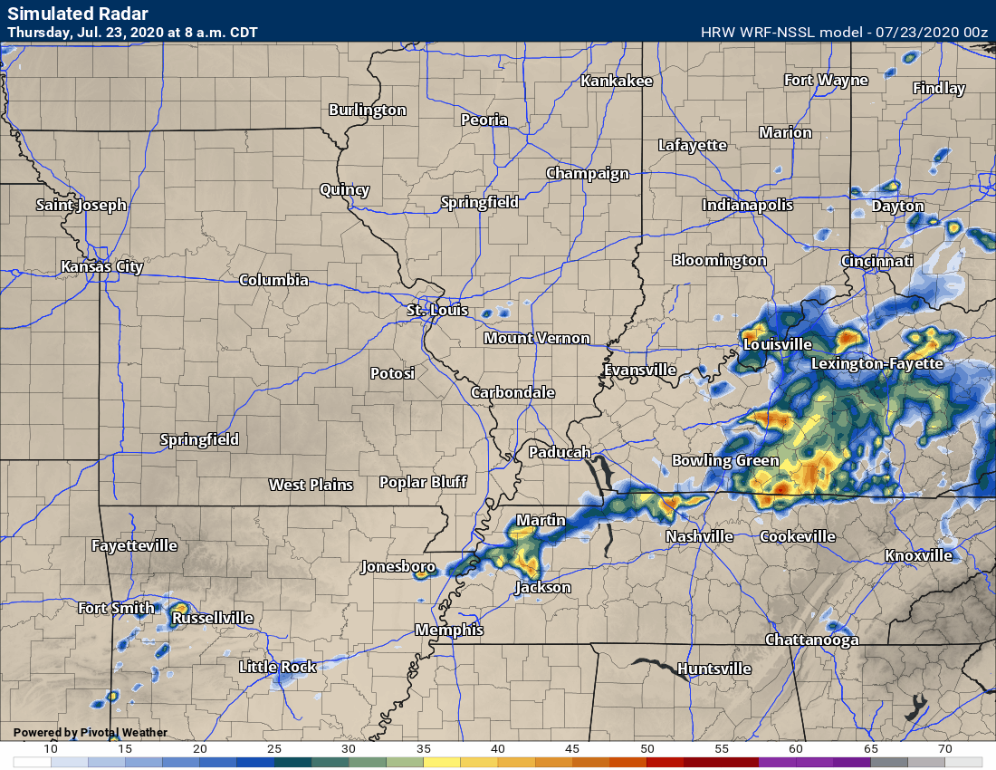
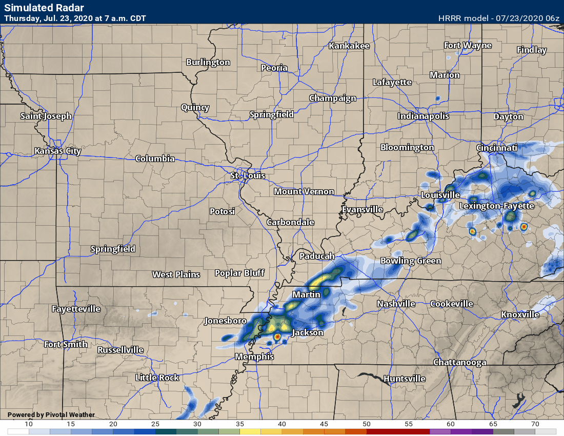
This animation is the Hrrr model.
This animation shows you what radar might look like as the next system pulls through the region. It is a future-cast radar.
Green is rain. Blue is snow. Pink and red represent sleet and freezing rain.
Time-stamp upper left. Click the animation to enlarge it.
Models handle afternoo
.
This animation is the SPC WRF model.
This animation shows you what radar might look like as the next system pulls through the region. It is a future-cast radar.
Green is rain. Blue is snow. Pink and red represent sleet and freezing rain.
Time-stamp upper left. Click the animation to enlarge it.
Models handle afternoon and evening thunderstorms poorly. Keep that in mind.
.
This animation is the 3K American Model.
This animation shows you what radar might look like as the next system pulls through the region. It is a future-cast radar.
Green is rain. Blue is snow. Pink and red represent sleet and freezing rain.
Time-stamp upper left. Click the animation to enlarge it.
Models handle afternoon and evening thunderstorms poorly. Keep that in mind.
.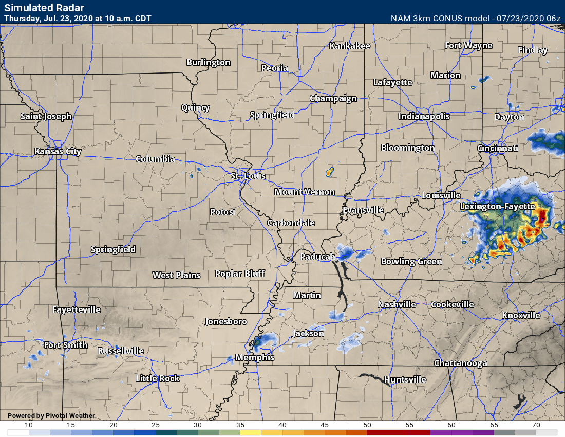
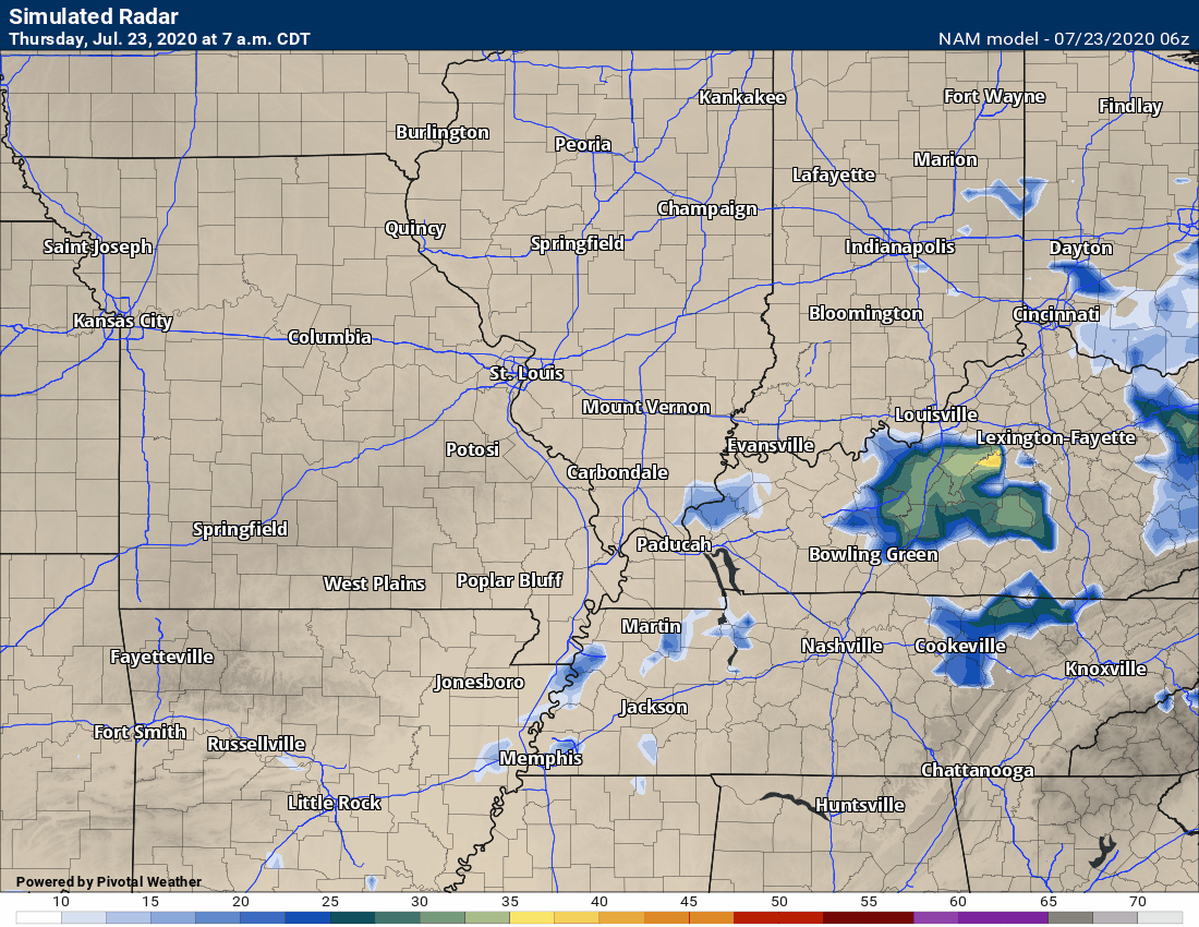
This next animation is the NAM American Model.
This animation shows you what radar might look like as the system pulls through the region. It is a future-cast radar.
Green is rain. Blue is snow. Pink and red represent sleet and freezing rain.
Time-stamp upper left. Click the animation to enlarge it.
Models handle afternoon and evening thunderstorms poorly. Keep that in mind.
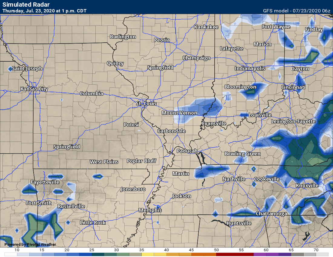
This next animation is the GFS American Model.
This animation shows you what radar might look like as the system pulls through the region. It is a future-cast radar.
Green is rain. Blue is snow. Pink and red represent sleet and freezing rain.
Time-stamp upper left. Click the animation to enlarge it.
Models handle afternoon and evening thunderstorms poorly. Keep that in mind.
![]()
.

.
Click here if you would like to return to the top of the page.
.
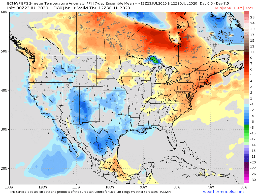
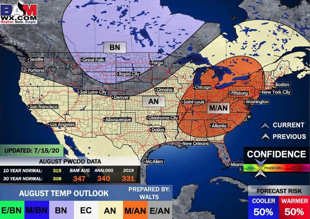
Average high temperatures for this time of the year are around 89 degrees.
Average low temperatures for this time of the year are around 69 degrees.
Average precipitation during this time period ranges from 0.60″ to 0.90″
Yellow and orange colors are above average temperatures. Red is much above average. Light blue and blue are below-average temperatures. Green to purple colors represents much below-average temperatures.
This outlook covers July 23rd through July 29th
Click on the image to expand it.
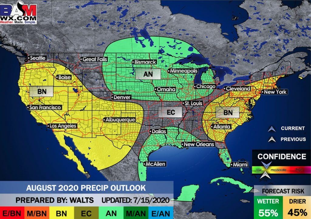
.
The precipitation forecast is PERCENT OF AVERAGE. Brown is below average. Green is above average. Blue is much above average.
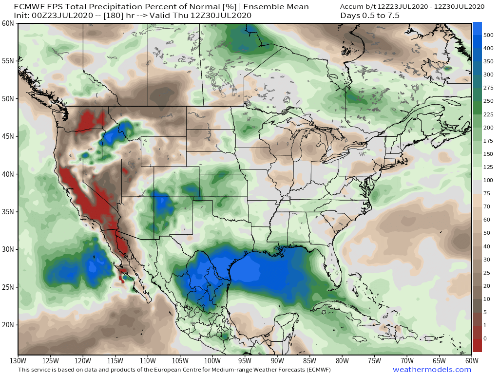

Average low temperatures for this time of the year are around 68 degrees
Average precipitation during this time period ranges from 0.60″ to 0.90″
.
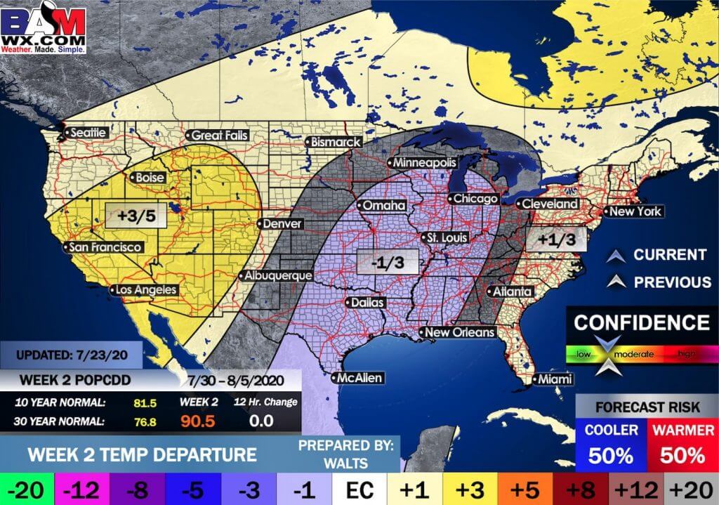
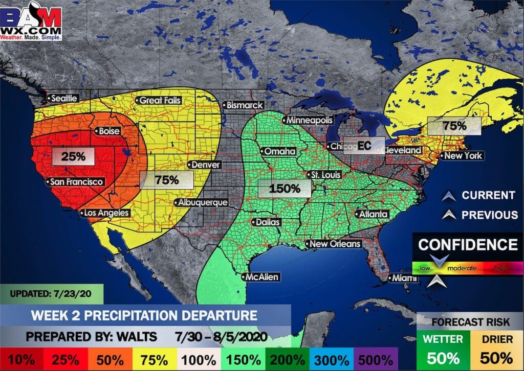
This outlook covers July 30th through August 5th
Click on the image to expand it.
.
The precipitation forecast is PERCENT OF AVERAGE. For example, if your average rainfall is 1.00″ and the graphic shows 25%, then that would mean 0.25″ of rain is anticipated.
.

EC = Equal chances of above or below average
BN= Below average
M/BN = Much below average
AN = Above average
M/AN = Much above average
E/AN = Extremely above average
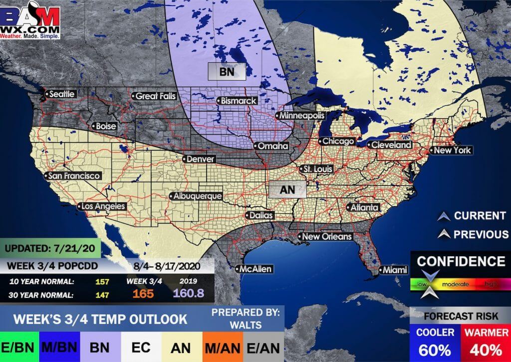
Average low temperatures for this time of the year are around 69 degrees
Average precipitation during this time period ranges from 1.20″ to 1.60″
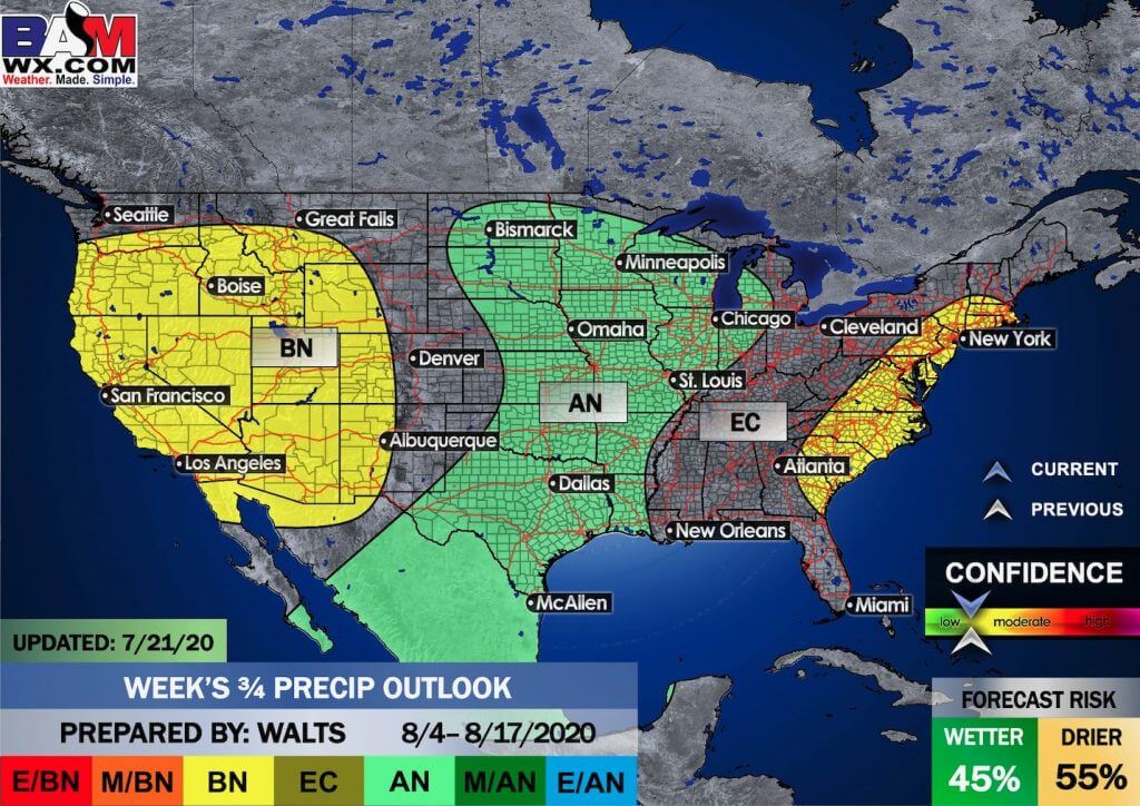
This outlook covers August 4th through August 17th
.
Precipitation outlook
 1
1
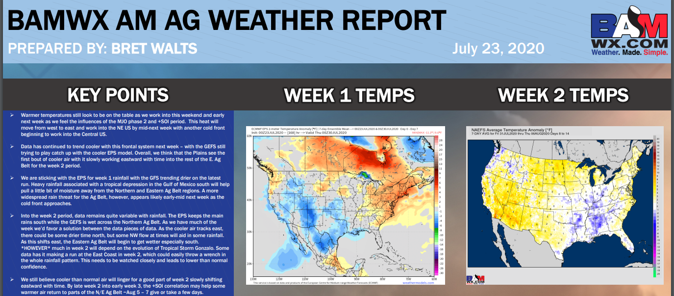
LONG RANGE DISCUSSION
Key Points: This was written by the BAMwx team. I don’t edit it.
Click to enlarge all of the images below
These graphics are updated Monday through Friday between 8:30 AM and 9:30 AM.
NOTE: These may not be updated on Saturday and Sunday.
Click the image below to enlarge it.
.
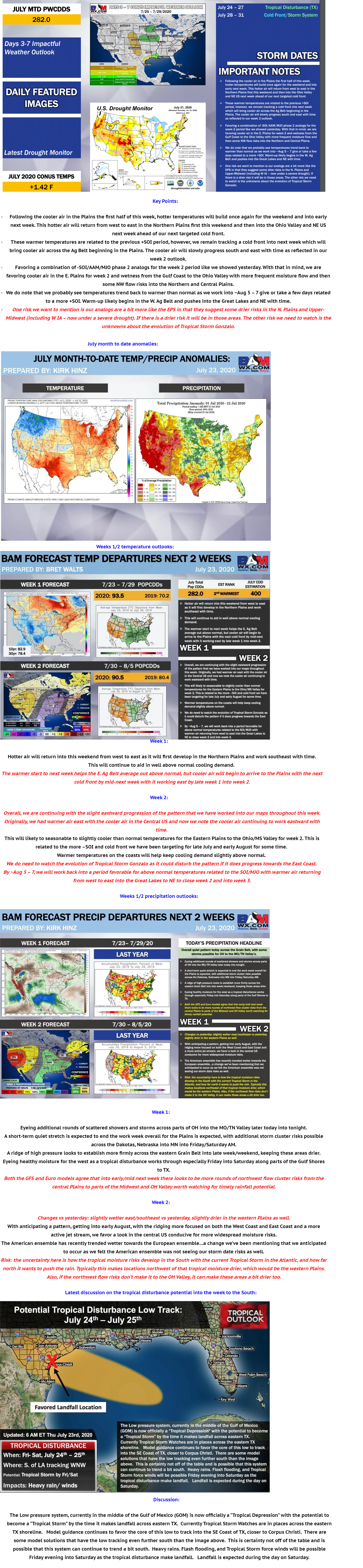
Summer outlook
Click to enlarge it. Then, you can read it better.
June through August
Temperature departures
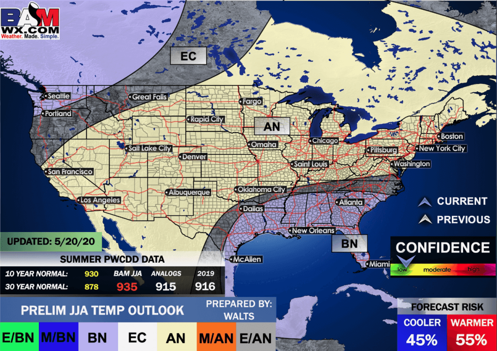
Precipitation
,
Click on the images to enlarge them
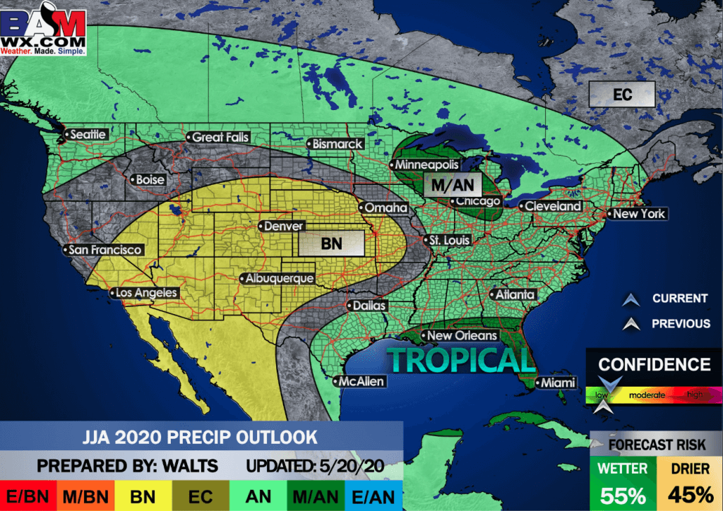
July Precipitation

Click on the images to enlarge them
.
![]()

Great news! The videos are now found in your Weathertalk app and on the WeatherTalk website.
These are bonus videos for subscribers.
The app is for subscribers. Subscribe at www.weathertalk.com/welcome then go to your app store and search for WeatherTalk
Subscribers, PLEASE USE THE APP. ATT and Verizon are not reliable during severe weather. They are delaying text messages.
The app is under WeatherTalk in the app store.

Apple users click here

Android users click here
.

Radar Link: Interactive local city-view radars & regional radars.
You will find clickable warning and advisory buttons on the local city-view radars.
If the radar is not updating then try another one. If a radar does not appear to be refreshing then hit Ctrl F5. You may also try restarting your browser.
Not working? Email me at beaudodson@usawx.com
National map of weather watches and warnings. Click here.
Storm Prediction Center. Click here.
Weather Prediction Center. Click here.
.

Live lightning data: Click here.
.

Interactive GOES R satellite. Track clouds. Click here.
GOES 16 slider tool. Click here.
College of Dupage satellites. Click here
.

Here are the latest local river stage forecast numbers Click Here.
Here are the latest lake stage forecast numbers for Kentucky Lake and Lake Barkley Click Here.
.
.
Find Beau on Facebook! Click the banner.


 .
.