.
Click one of the links below to take you directly to that section
![]()
![]()
![]()
![]()
![]()
![]()
![]()
Do you have any suggestions or comments? Email me at beaudodson@usawx.com
.
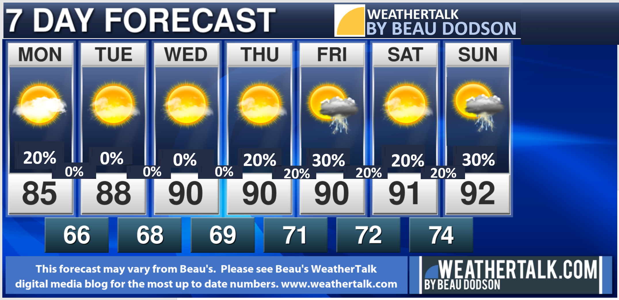
7-day forecast for southeast Missouri, southern Illinois, western Kentucky, and western Tennessee.
This is a BLEND for the region. See the detailed region by region forecast further down in this post.
THE FORECAST IS GOING TO VARY FROM LOCATON TO LOCATION.
SEE THE DAILY DETAILS (REGION BY REGION) FURTHER DOWN IN THIS BLOG UPDATE.
48-hour forecast


.

.
Monday to Monday
1. Is lightning in the forecast? Yes. A small chance today along the AR/MO and KY/TN border areas. Isolated thunderstorms Thursday. Scattered Friday. Isolated Saturday and scattered Sunday.
2. Are severe thunderstorms in the forecast? Not at this time.
The NWS officially defines a severe thunderstorm as a storm with 58 mph wind or greater, 1″ hail or larger, and/or tornadoes
3. Is flash flooding in the forecast? Not at this time.
4. Will the heat index top 100 degrees? No.
5. Will the wind chill dip below 10 degrees above zero? No.
6. Will there be accumulating snow and ice in the forecast? No.
.

July 19, 2021
How confident am I that this days forecast will verify? High confidence
Monday Forecast: Partly to mostly sunny. A chance of an isolated shower or thunderstorm over far southeast Missouri, western Kentucky and northwest Tennessee. The chances are higher the further south you travel vs areas to the north. The boundary has pushed southward over the past 24 hours.
What is the chance of precipitation? MO Bootheel ~ 30% / SE MO ~ 20% / I-64 Corridor South IL ~ 10% / South IL ~ 20% / West KY ~ 30% / NW KY (near Indiana border) ~ 20% / NW TN ~ 30%
Coverage of precipitation: Widely scattered over mainly our southern counties
Timing of the rain: Any given point of time
Temperature range: MO Bootheel 82° to 85° / SE MO 84° to 86° / South IL 84° to 86° / Northwest KY (near Indiana border) 84° to 86° / West KY 84° to 86° / NW TN 82° to 85°
Wind direction and speed: East northeast 5 to 10 mph
Wind chill or heat index (feels like) temperature forecast: 82° to 88°
What impacts are anticipated from the weather? Wet roadways. Lightning.
Should I cancel my outdoor plans? No. Check the weather radars.
UV Index: 10. Very high
Sunrise: 5:50 AM
Sunset: 8:13 PM
.
Monday night Forecast: Mostly clear. Mild. Patchy fog.
What is the chance of precipitation? MO Bootheel ~ 0% / SE MO ~ 0% / I-64 Corridor South IL ~ 0% / South IL ~ 0% / West KY ~ 0% / NW KY (near Indiana border) ~ 0% / NW TN ~ 0%
Coverage of precipitation:
Timing of the rain:
Temperature range: MO Bootheel 64° to 68° / SE MO 64° to 68° / South IL 64° to 68° / Northwest KY (near Indiana border) 64° to 68° / West KY 64° to 68° / NW TN 64° to 68°
Wind direction and speed: Light north northeast wind.
Wind chill or heat index (feels like) temperature forecast: 64° to 68°
What impacts are anticipated from the weather? None
Should I cancel my outdoor plans? No
Moonrise: 3:58 PM
Moonset: 1:30 AM
The phase of the moon: Waxing Gibbous
.
July 20, 2021
How confident am I that this days forecast will verify? High confidence
Tuesday Forecast: Mostly sunny. A few passing clouds. Warm.
What is the chance of precipitation? MO Bootheel ~ 0% / SE MO ~ 0% / I-64 Corridor South IL ~ 0% / South IL ~ 0% / West KY ~ 0% / NW KY (near Indiana border) ~ 0% / NW TN ~ 0%
Coverage of precipitation:
Timing of the rain:
Temperature range: MO Bootheel 85° to 90° / SE MO 85° to 90° / South IL 85° to 90° / Northwest KY (near Indiana border) 85° to 90° / West KY 85° to 90° / NW TN 85° to 90°
Wind direction and speed: North northeast 5 to 10 mph
Wind chill or heat index (feels like) temperature forecast: 85° to 90°
What impacts are anticipated from the weather? None
Should I cancel my outdoor plans? No
UV Index: 10. Very high
Sunrise: 5:50 AM
Sunset: 8:13 PM
.
Tuesday night Forecast: Mostly clear. Mild.
What is the chance of precipitation? MO Bootheel ~ 0% / SE MO ~ 0% / I-64 Corridor South IL ~ 0% / South IL ~ 0% / West KY ~ 0% / NW KY (near Indiana border) ~ 0% / NW TN ~ 0%
Coverage of precipitation:
Timing of the rain:
Temperature range: MO Bootheel 66° to 68° / SE MO 66° to 68° / South IL 66° to 68° / Northwest KY (near Indiana border) 66° to 68° / West KY 66° to 68° / NW TN 66° to 70°
Wind direction and speed: Northerly winds 5 to 10 mph
Wind chill or heat index (feels like) temperature forecast: 66° to 70°
What impacts are anticipated from the weather? None
Should I cancel my outdoor plans? No
Moonrise: 5:11 PM
Moonset: 2:10 AM
The phase of the moon: Waxing Gibbous
.
July 21, 2021
How confident am I that this days forecast will verify? High confidence
Wednesday Forecast: Mostly sunny. Warm.
What is the chance of precipitation? MO Bootheel ~ 0% / SE MO ~ 0% / I-64 Corridor South IL ~ 0% / South IL ~ 0% / West KY ~ 0% / NW KY (near Indiana border) ~ 0% / NW TN ~ 0%
Coverage of precipitation:
Timing of the rain:
Temperature range: MO Bootheel 85° to 90° / SE MO 85° to 90° / South IL 85° to 90° / Northwest KY (near Indiana border) 85° to 90° / West KY 85° to 90° / NW TN 85° to 90°
Wind direction and speed: Northerly at 5 mph
Wind chill or heat index (feels like) temperature forecast: 85° to 90°
What impacts are anticipated from the weather? None
Should I cancel my outdoor plans? No
UV Index: 10. Very high
Sunrise: 5:51 AM
Sunset: 8:12 PM
.
Wednesday night Forecast: Mostly clear. Mild.
What is the chance of precipitation? MO Bootheel ~ 0% / SE MO ~ 0% / I-64 Corridor South IL ~ 0% / South IL ~ 0% / West KY ~ 0% / NW KY (near Indiana border) ~ 0% / NW TN ~ 0%
Coverage of precipitation:
Timing of the rain:
Temperature range: MO Bootheel 66° to 70° / SE MO 66° to 70° / South IL 66° to 70° / Northwest KY (near Indiana border) 66° to 70° / West KY 66° to 70° / NW TN 66° to 70°
Wind direction and speed:
Wind chill or heat index (feels like) temperature forecast: 66° to 70°
What impacts are anticipated from the weather? None
Should I cancel my outdoor plans? No
Moonrise: 6:23 PM
Moonset: 2:58 AM
The phase of the moon: Waxing Gibbous
.
July 22, 2021
How confident am I that this days forecast will verify? High confidence
Thursday Forecast: Partly sunny. Hot. A slight chance of a thunderstorm.
What is the chance of precipitation? MO Bootheel ~ 20% / SE MO ~ 20% / I-64 Corridor South IL ~ 20% / South IL ~ 20% / West KY ~ 20% / NW KY (near Indiana border) ~ 20% / NW TN ~ 30%
Coverage of precipitation: Isolated to widely scattered
Timing of the rain: After 12 PM
Temperature range: MO Bootheel 88° to 92° / SE MO 88° to 92° / South IL 88° to 92° / Northwest KY (near Indiana border) 88° to 92° / West KY 88° to 92° / NW TN 88° to 92°
Wind direction and speed: South southwest 5 to 10 mph
Wind chill or heat index (feels like) temperature forecast: 90° to 94°
What impacts are anticipated from the weather? Isolated wet roadways. Lightning.
Should I cancel my outdoor plans? No. Check the weather radars.
UV Index: 10. Very high
Sunrise: 5:52 AM
Sunset: 8:11 PM
.
Thursday night Forecast: Partly cloudy. A slight chance of a shower or thunderstorm.
What is the chance of precipitation? MO Bootheel ~ 20% / SE MO ~ 10% / I-64 Corridor South IL ~ 10% / South IL ~ 10% / West KY ~ 10% / NW KY (near Indiana border) ~ 10% / NW TN ~ 10%
Coverage of precipitation: Isolated
Timing of the rain: Any given point of time.
Temperature range: MO Bootheel 66° to 70° / SE MO 66° to 70° / South IL 66° to 70° / Northwest KY (near Indiana border) 66° to 70° / West KY 66° to 70° / NW TN 66° to 70°
Wind direction and speed: South southwest wind 5 mph
Wind chill or heat index (feels like) temperature forecast: 66° to 72°
What impacts are anticipated from the weather? None for most. Isolated wet roadway. Isolated lightning.
Should I cancel my outdoor plans? No. Check the radars.
Moonrise: 7:27 PM
Moonset: 3:55 AM
The phase of the moon: Waxing Gibbous
.
July 23, 2021
How confident am I that this days forecast will verify? Medium confidence
Friday Forecast: Partly sunny. Hot. A slight chance of showers and thunderstorms.
What is the chance of precipitation? MO Bootheel ~ 30% / SE MO ~ 30% / I-64 Corridor South IL ~ 30% / South IL ~ 30% / West KY ~ 40% / NW KY (near Indiana border) ~ 40% / NW TN ~ 40%
Coverage of precipitation: Scattered
Timing of the rain: Any given point of time. Highest coverage during the PM hours vs the AM hours.
Temperature range: MO Bootheel 88° to 92° / SE MO 88° to 92° / South IL 88° to 92° / Northwest KY (near Indiana border) 88° to 92° / West KY 88° to 92° / NW TN 88° to 92°
Wind direction and speed: Southwest 6 to 12 mph
Wind chill or heat index (feels like) temperature forecast: 88° to 94°
What impacts are anticipated from the weather? Wet roadways. Lightning.
Should I cancel my outdoor plans? No. Check the weather radars.
UV Index: 10. Very high
Sunrise: 5:53 AM
Sunset: 8:11 PM
.
Friday night Forecast: Mostly clear. Warm. A thunderstorm is possible.
What is the chance of precipitation? MO Bootheel ~ 20% / SE MO ~ 20% / I-64 Corridor South IL ~ 20% / South IL ~ 20% / West KY ~ 20% / NW KY (near Indiana border) ~ 20% / NW TN ~ 20%
Coverage of precipitation: Scattered
Timing of the rain: Mainly before 12 AM
Temperature range: MO Bootheel 68° to 72° / SE MO 66° to 72° / South IL 66° to 72° / Northwest KY (near Indiana border) 66° to 72° / West KY 66° to 72° / NW TN 66° to 72°
Wind direction and speed: South southwest 5 mph
Wind chill or heat index (feels like) temperature forecast: 66° to 70°
What impacts are anticipated from the weather? Wet roadways. Lightning.
Should I cancel my outdoor plans? No. Check the radars.
Moonrise: 8:23 PM
Moonset: 5:01 AM
The phase of the moon: Full
.
July 24, 2021
How confident am I that this days forecast will verify? Medium confidence
Saturday Forecast: Partly to mostly sunny. Hot. A slight chance of a shower or thunderstorm.
What is the chance of precipitation? MO Bootheel ~ 20% / SE MO ~ 20% / I-64 Corridor South IL ~ 20% / South IL ~ 20% / West KY ~ 20% / NW KY (near Indiana border) ~ 20% / NW TN ~ 20%
Coverage of precipitation: Widely scattered
Timing of the rain: Mostly during the afternoon
Temperature range: MO Bootheel 88° to 94° / SE MO 88° to 94° / South IL 88° to 94° / Northwest KY (near Indiana border) 88° to 94° / West KY 88° to 94° / NW TN 88° to 94°
Wind direction and speed: South southwest 6 to 12 mph
Wind chill or heat index (feels like) temperature forecast: 90° to 95°
What impacts are anticipated from the weather? Isolated wet roadways. Isolated lightning. Locally heavy downpours where thunderstorms occur.
Should I cancel my outdoor plans? No. Check the radars.
UV Index: 10. Very high
Sunrise: 5:54 AM
Sunset: 8:10 PM
.
Saturday night Forecast: Partly cloudy. A slight chance of a thunderstorm.
What is the chance of precipitation? MO Bootheel ~ 20% / SE MO ~ 20% / I-64 Corridor South IL ~ 20% / South IL ~ 20% / West KY ~ 20% / NW KY (near Indiana border) ~ 20% / NW TN ~ 20%
Coverage of precipitation: Widely scattered
Timing of the rain: Mostly before midnight
Temperature range: MO Bootheel 72° to 75° / SE MO 72° to 74° / South IL 72° to 74° / Northwest KY (near Indiana border) 72° to 74° / West KY 72° to 74° / NW TN 72° to 74°
Wind direction and speed: South southwest 4 to 8 mph
Wind chill or heat index (feels like) temperature forecast: 72° to 74°
What impacts are anticipated from the weather? Wet roadways. Lightning.
Should I cancel my outdoor plans? No. Check the weather radars.
Moonrise: 9:08 PM
Moonset: 6:11 AM
The phase of the moon: Full
.
July 25, 2021
How confident am I that this days forecast will verify? Medium confidence
Sunday Forecast: Partly cloudy. A chance of showers and thunderstorms. Warm and humid.
What is the chance of precipitation? MO Bootheel ~ 30% / SE MO ~ 30% / I-64 Corridor South IL ~ 30% / South IL ~ 30% / West KY ~ 30% / NW KY (near Indiana border) ~ 30% / NW TN ~ 30%
Coverage of precipitation: Widely scattered
Timing of the rain: Mostly during the afternoon
Temperature range: MO Bootheel 88° to 94° / SE MO 88° to 94° / South IL 88° to 94° / Northwest KY (near Indiana border) 88° to 94° / West KY 88° to 94° / NW TN 88° to 94°
Wind direction and speed: South southwest 6 to 12 mph
Wind chill or heat index (feels like) temperature forecast: 92° to 96°
What impacts are anticipated from the weather? Wet roadways. Lightning. Locally heavy downpours where thunderstorms occur.
Should I cancel my outdoor plans? No. Check the radars.
UV Index: 10. Very high
Sunrise: 5:54 AM
Sunset: 8:09 PM
.
Sunday night Forecast: Partly cloudy. A chance of a shower or thunderstorm.
What is the chance of precipitation? MO Bootheel ~ 20% / SE MO ~ 20% / I-64 Corridor South IL ~ 20% / South IL ~ 20% / West KY ~ 20% / NW KY (near Indiana border) ~ 20% / NW TN ~ 20%
Coverage of precipitation: Widely scattered
Timing of the rain: Mostly before midnight.
Temperature range: MO Bootheel 68° to 72° / SE MO 66° to 72° / South IL 66° to 72° / Northwest KY (near Indiana border) 66° to 72° / West KY 66° to 72° / NW TN 66° to 72°
Wind direction and speed: South southwest 5 to 10 mph
Wind chill or heat index (feels like) temperature forecast: 70° to 72°
What impacts are anticipated from the weather? Wet roadways. Lightning.
Should I cancel my outdoor plans? No. Check the weather radars.
Moonrise: 9:45 PM
Moonset: 7:21 AM
The phase of the moon: Waning Gibbous
.
.

These graphics are changed out between 10:00 AM and 11:00 AM (Monday through Friday only)
Double click on the images to enlarge them.
Click the images to enlarge them.
CLICK IMAGES TO ENLARGE THEM
![]()
![]()
Graphic-cast
Click here if you would like to return to the top of the page.
Illinois
During active weather check my handwritten forecast towards the top of the page.

.
Kentucky
During active weather check my handwritten forecast towards the top of the page.


.

.

.
.Tennessee
During active weather check my handwritten forecast towards the top of the page.

.
.
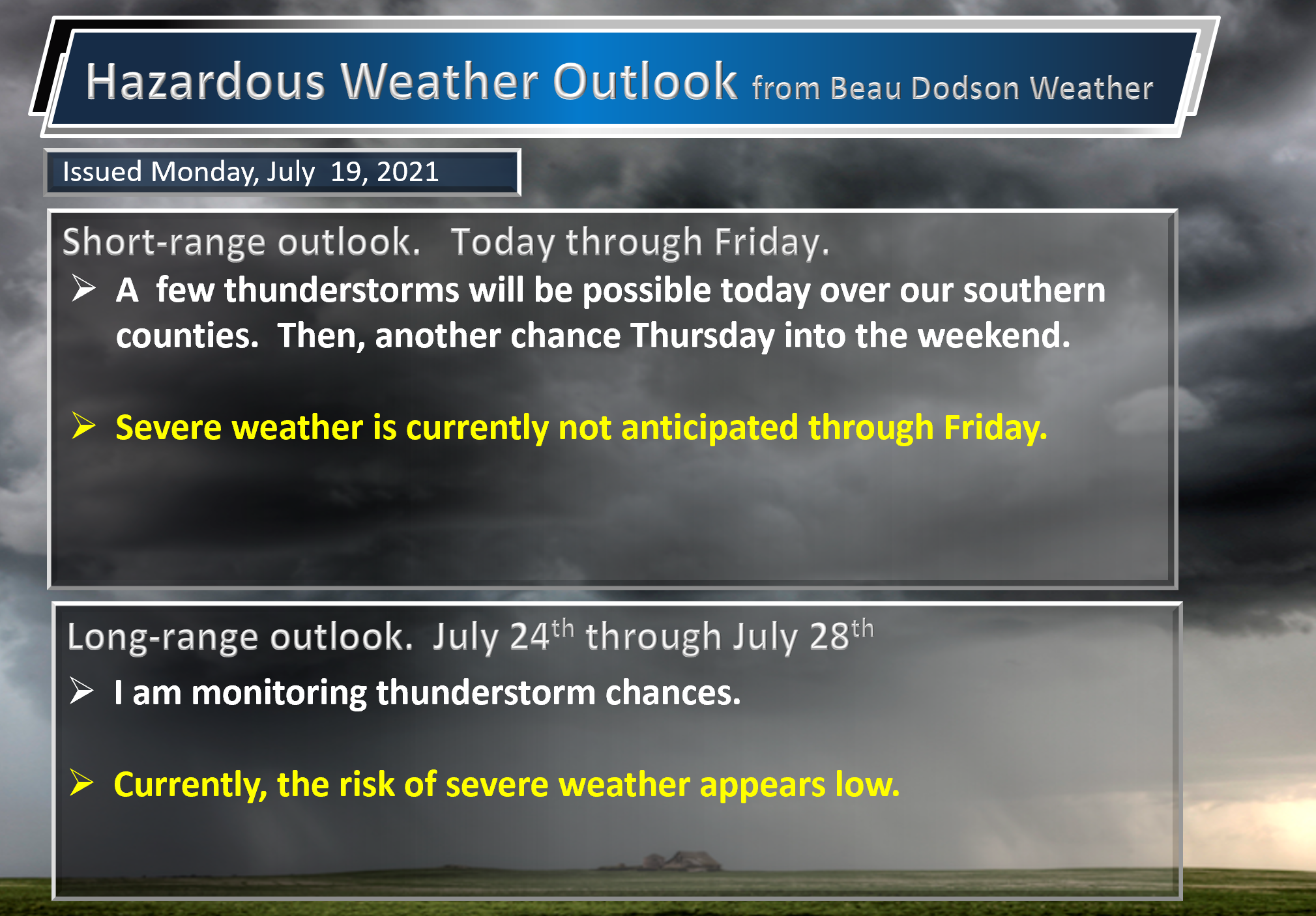
Today through July 26th: Currently, I am not forecasting severe weather through Sunday. As always, monitor updates.

.
Today’s outlook (below).
Light green is where thunderstorms may occur but should be below severe levels.
Dark green is a level one risk. Yellow is a level two risk. Orange is a level three (enhanced) risk. Red is a level four (moderate) risk. Pink is a level five (high) risk.
One is the lowest risk. Five is the highest risk.
A severe storm is one that produces 58 mph wind or higher, quarter size hail, and/or a tornado.
The tan states are simply a region that SPC outlined on this particular map. Just ignore that.

The black outline is our local area.

.
Tomorrow’s severe weather outlook.

.

.
The images below are from the WPC. Their totals are a bit lower than our current forecast. I wanted to show you the comparison.
24-hour precipitation outlook.
.
 .
.
48-hour precipitation outlook.
.
.
72-hour precipitation outlook.
.
.
![]()
![]()

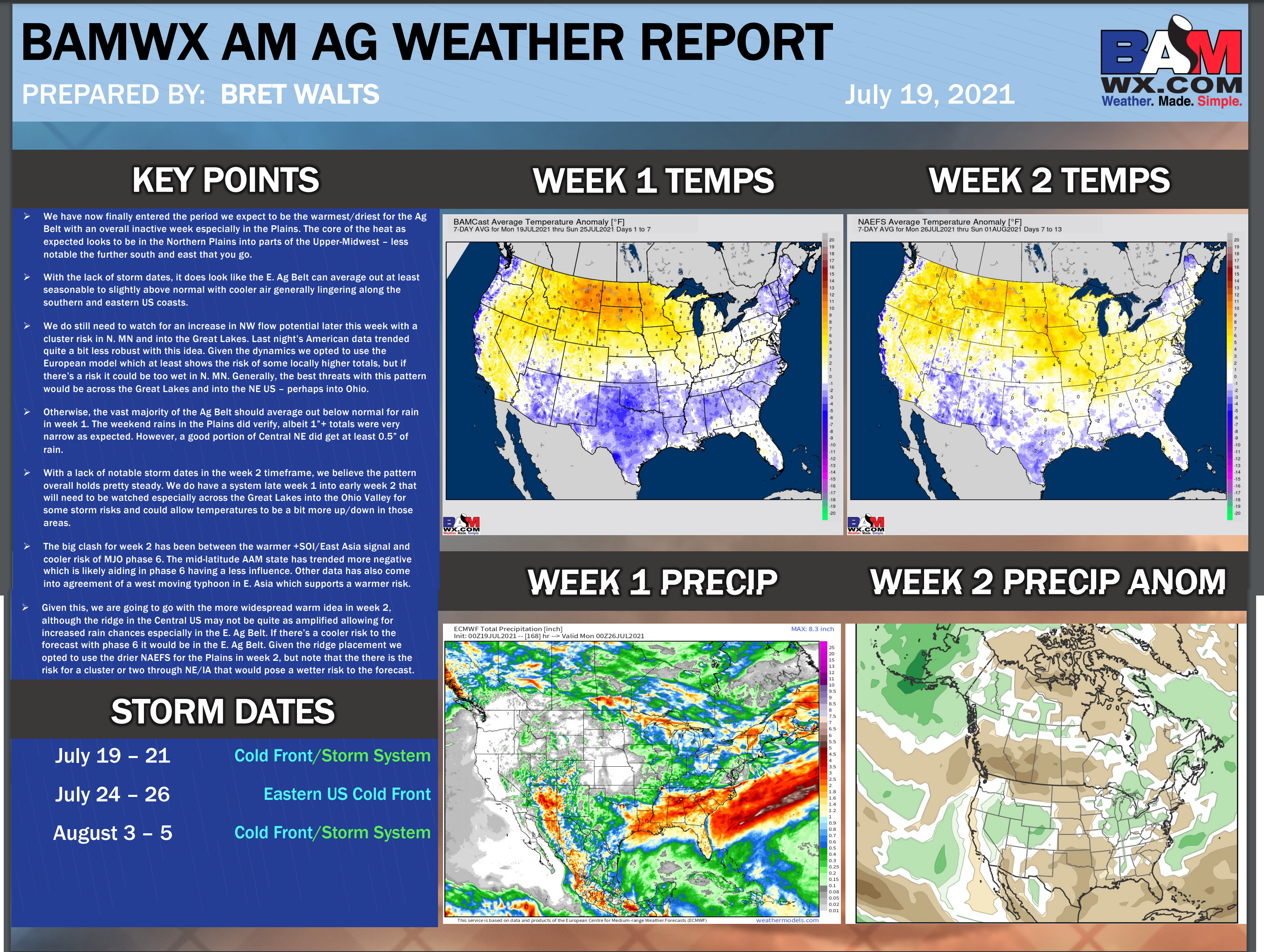
Weather Discussion
-
- Fairly calm weather over the coming days.
- Monitoring shower/thunderstorm chances today, Thursday, Friday, Saturday, and Sunday.
.
Weather advice:
Avoid flooded roadways. We still have rivers rising from the recent heavy rain.
Weather Discussion
I am back from vacation! Thank you for your patience.
We have a frontal boundary draped across our southern counties. This front was the reason we had extremely heavy rain over the last few days. There were some counties in southern Illinois, western Kentucky, southeast Missouri, and northwest Tennessee that picked up one to ten+ inches of rain! Incredible rain totals.
Check out some of these 24 to 48 hour totals. near Cape Girardeau. Over six inches! Click image to enlarge it.
Most of this fell Sunday.
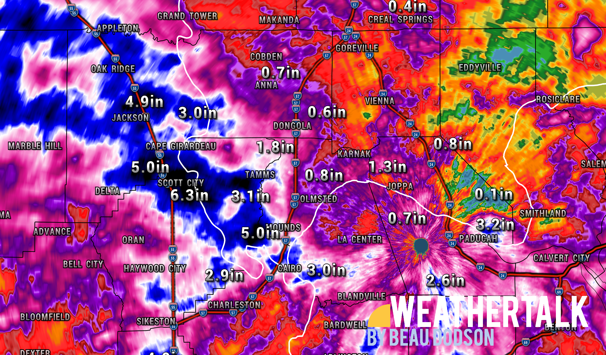
I have measured over 7.30″ of rain at The Weather Observatory in Massac County, Illinois, since June 29th. At least that was drawn out. Unlike many locations over the last few days.
Flash flooding killed at least one person in southern Illinois. A woman who had her car swept into the waters.
A few scattered showers and thunderstorms will be possible today along the Missouri and Arkansas and Kentucky and Tennessee state lines. The chances decrease as you travel further north. The chance is not zero further north, just lower.
The frontal boundary will finally push southward tonight and that should bring an end to showers and thunderstorms.
That leaves Tuesday and Wednesday drier. Decent days. It will be warm but nothing exceptional.
The atmosphere will become increasingly moist as we move into Thursday and the weekend. I have a low chance of showers and thunderstorms Thursday and then a bit higher chance Friday. Lower again Saturday and then a bit higher Sunday.
Those are a lot of details this far out. If the boundary location chances Thursday through Sunday then the % chances will need adjusting. Just keep that in mind. I would not cancel any weekend plans. I would monitor updates, as always.
.
.

Click here if you would like to return to the top of the page.
Again, as a reminder, these are models. They are never 100% accurate. Take the general idea from them.
What should I take from these?
- The general idea and not specifics. Models usually do well with the generalities.
- The time-stamp is located in the upper left corner.
- The EC European weather model is in Zulu time.
.
What am I looking at?
You are looking at different models. Meteorologists use many different models to forecast the weather. All models are wrong. Some are more wrong than others. Meteorologists have to make a forecast based on the guidance/models.
I show you these so you can see what the different models are showing as far as precipitation. If most of the models agree, then the confidence in the final weather forecast increases.
You can see my final forecast at the top of the page.
.
This animation is the Storm Prediction Center WRF model.
This animation shows you what radar might look like as the next system pulls through the region. It is a future-cast radar.
Time-stamp upper left. Click the animation to enlarge it.
.
.
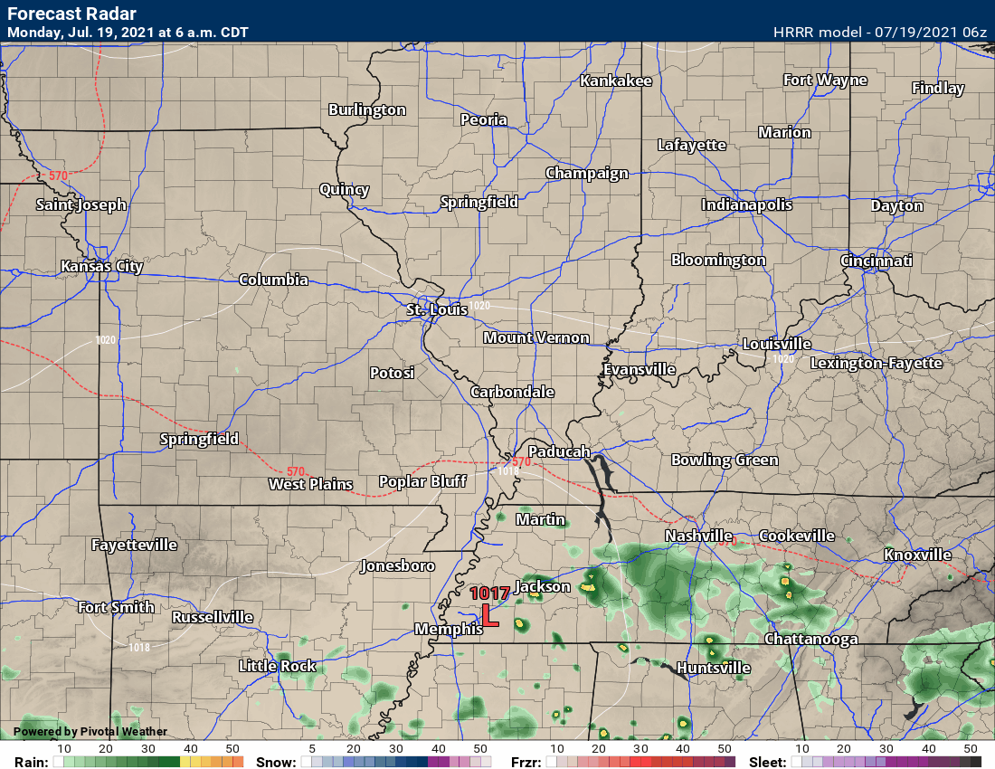
This animation is the Hrrr short-range model.
This animation shows you what radar might look like as the next system pulls through the region. It is a future-cast radar.
Time-stamp upper left. Click the animation to enlarge it.
.
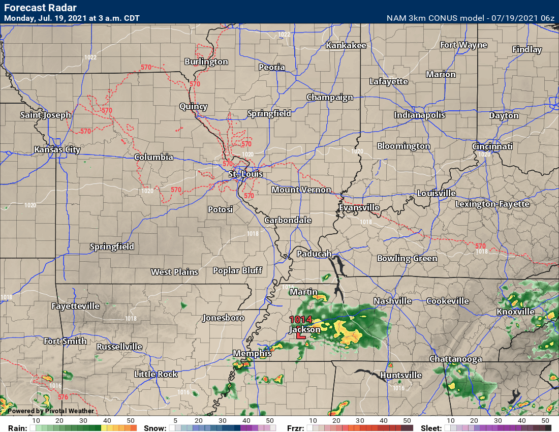
.This animation is the higher-resolution 3K NAM American Model.
This animation shows you what radar might look like as the next system pulls through the region. It is a future-cast radar.
Time-stamp upper left. Click the animation to enlarge it.
.
This next animation is the lower-resolution NAM American Model.
This animation shows you what radar might look like as the system pulls through the region. It is a future-cast radar.
Time-stamp upper left. Click the animation to enlarge it.
.
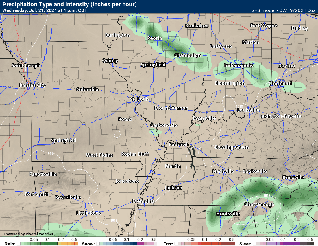
This next animation is the GFS American Model.
This animation shows you what radar might look like as the system pulls through the region. It is a future-cast radar.
Time-stamp upper left. Click the animation to enlarge it.
Longer range GFS
.
This next animation is the EC European Weather model.
This animation shows you what radar might look like as the system pulls through the region. It is a future-cast radar.
Time-stamp upper left. Click the animation to enlarge it.
Long range
.
.![]()
.

.
Click here if you would like to return to the top of the page.
.
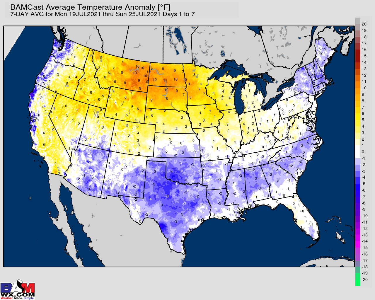
Average high temperatures for this time of the year are around 88 degrees.
Average low temperatures for this time of the year are around 68 degrees.
Average precipitation during this time period ranges from 1.00″ to 1.20″
Yellow and orange colors are above average temperatures. Red is much above average. Light blue and blue are below-average temperatures. Green to purple colors represents much below-average temperatures.
This outlook covers July 19th through July 25th
Click on the image to expand it.
.
The precipitation forecast is PERCENT OF AVERAGE. Brown is below average. Green is above average. Blue is much above average.
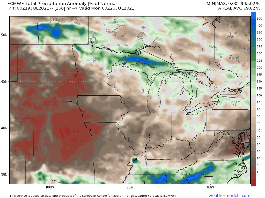

Average low temperatures for this time of the year are around 68 degrees
Average precipitation during this time period ranges from 1.00″ to 1.30″
.
This outlook covers July 26th through August 1st
Click on the image to expand it.
The precipitation forecast is PERCENT OF AVERAGE. Brown is below average. Green is above average. Blue is much above average.

.

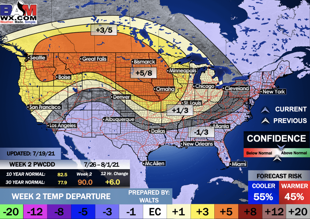
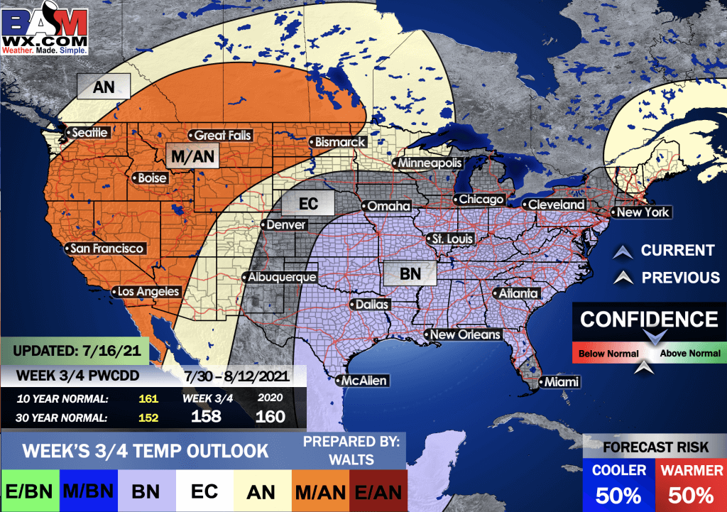
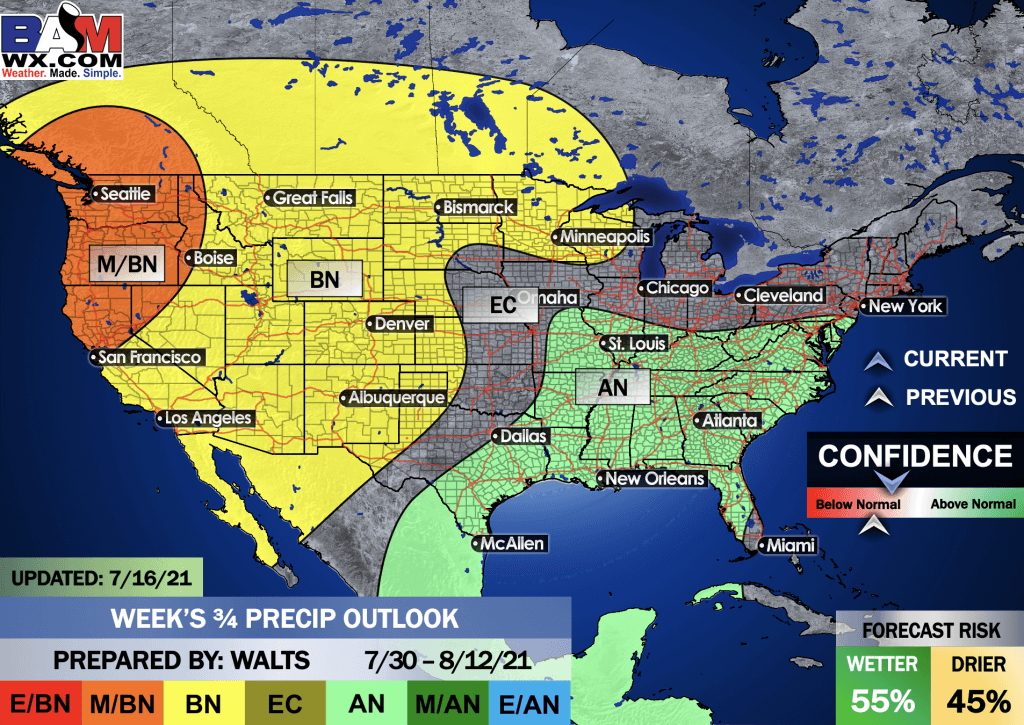
EC = Equal chances of above or below average
BN= Below average
M/BN = Much below average
AN = Above average
M/AN = Much above average
E/AN = Extremely above average
Average low temperatures for this time of the year are around 68 degrees
Average precipitation during this time period ranges from 1.80″ to 2.10″
This outlook covers July 30th through August 12th
.
Precipitation outlook
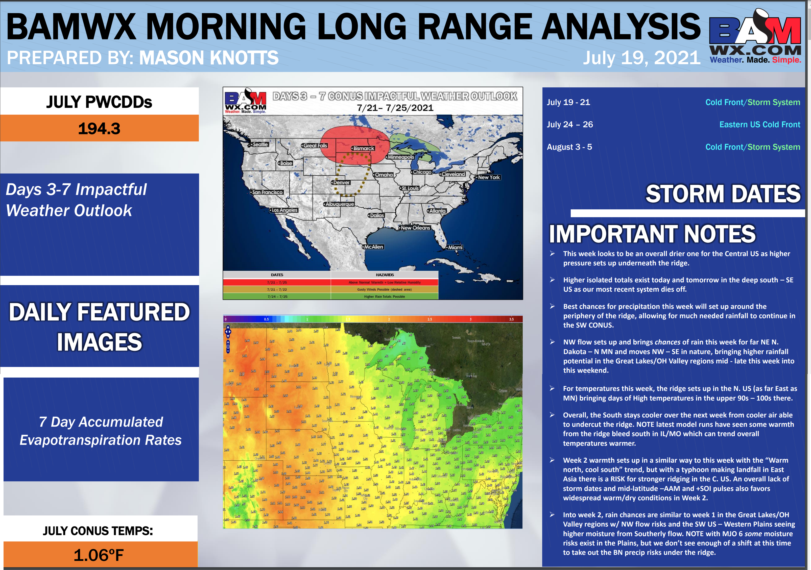
LONG RANGE DISCUSSION
Key Points: This was written by the BAMwx team. I don’t edit it.
Temperature departures
Preliminary outlooks
E/BN extremely below normal.
M/BN is much below normal
EC equal chances
AN above normal
M/AN much above normal
E/AN extremely above normal.
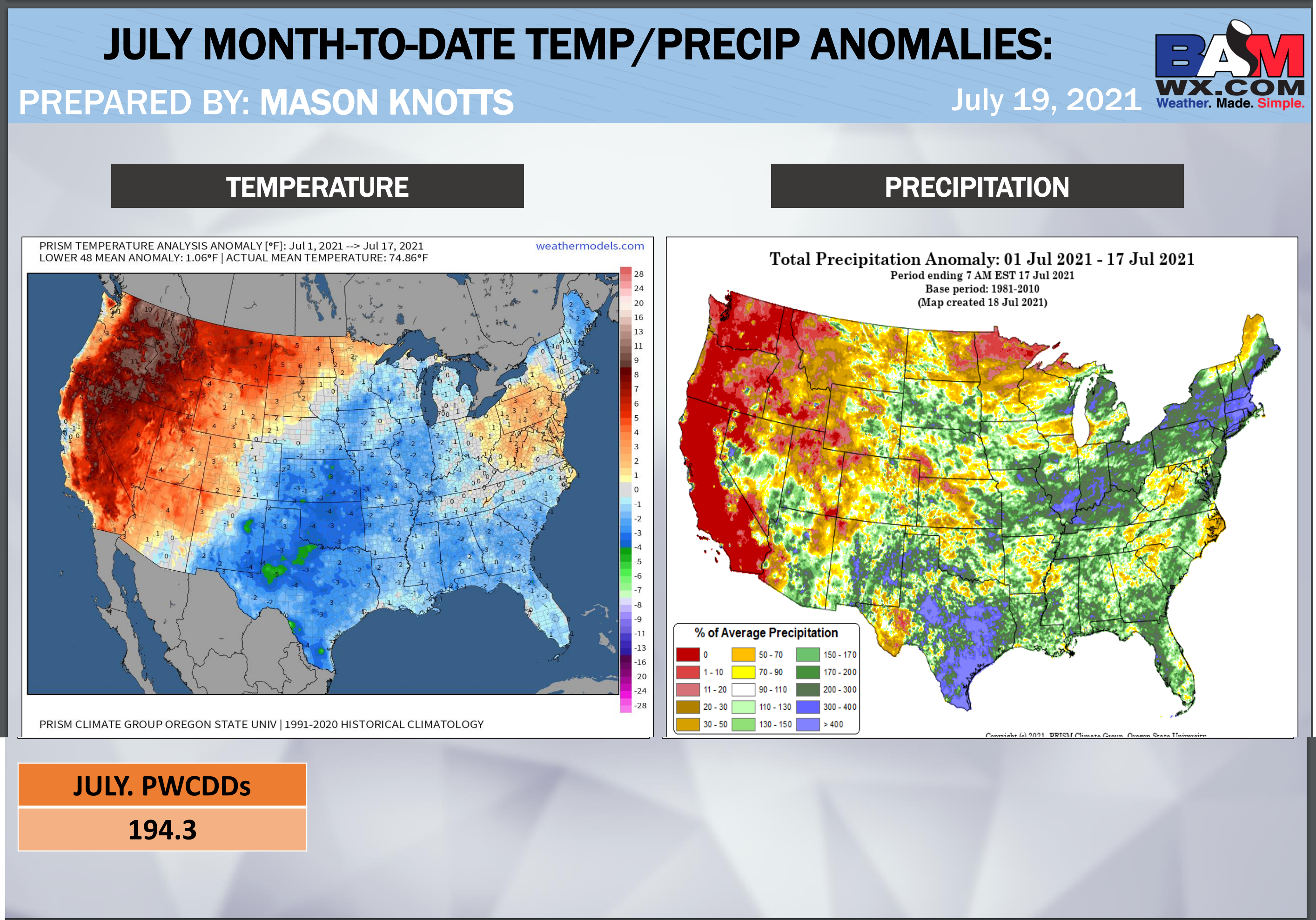
July Temperature Outlook
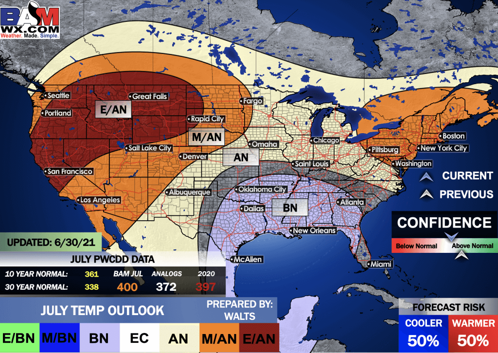
July precipitation outlook
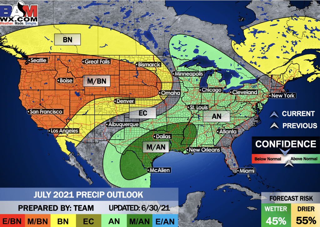
.
Preliminary outlooks
E/BN extremely below normal.
M/BN is much below normal
EC equal chances
AN above normal
M/AN much above normal
E/AN extremely above normal.
August Temperature Outlook
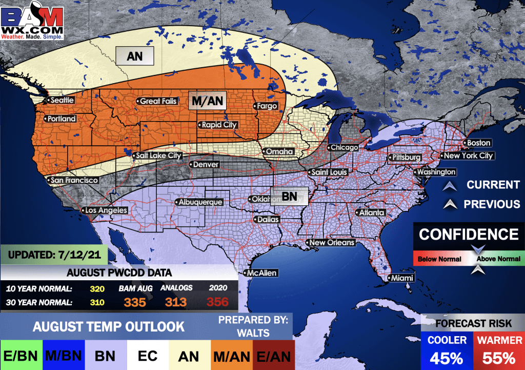
August precipitation outlook
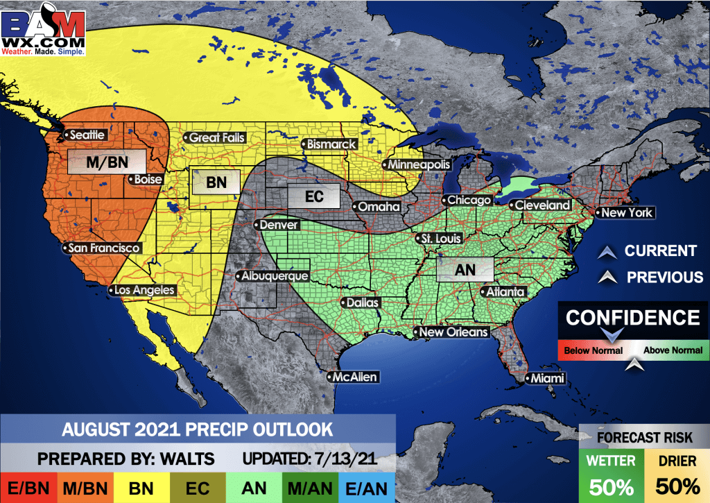
.
Preliminary outlooks
E/BN extremely below normal.
M/BN is much below normal
EC equal chances
AN above normal
M/AN much above normal
E/AN extremely above normal.
September Temperature Outlook
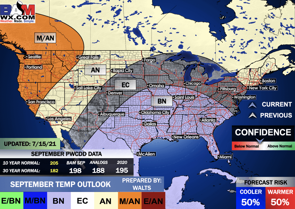
September precipitation outlook
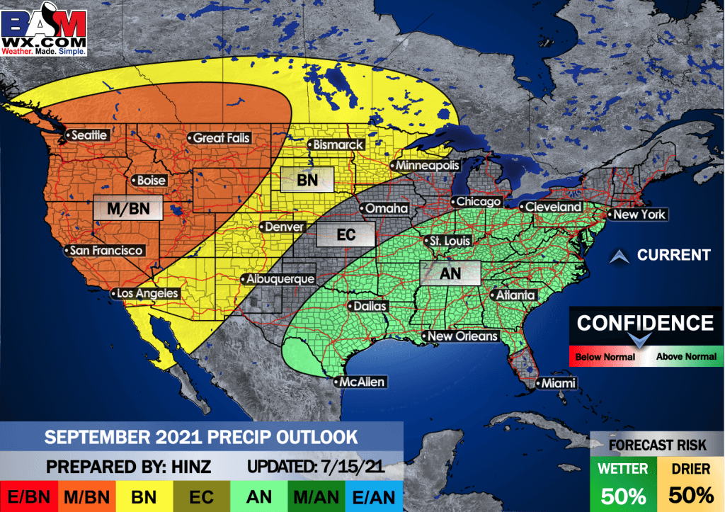
.
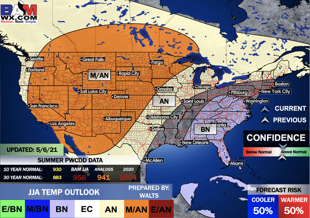
Summer Outlook
E/BN extremely below normal.
M/BN is much below normal
EC equal chances
AN above normal
M/AN much above normal
E/AN extremely above normal.
June, July, and August Temperature Outlook
.
E/BN extremely below normal.
M/BN is much below normal
EC equal chances
AN above normal
M/AN much above normal
E/AN extremely above normal.
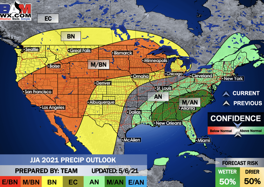
June, July, and August Precipitation Outlook
.
![]()

Great news! The videos are now found in your Weathertalk app and on the WeatherTalk website.
These are bonus videos for subscribers.
The app is for subscribers. Subscribe at www.weathertalk.com/welcome then go to your app store and search for WeatherTalk
Subscribers, PLEASE USE THE APP. ATT and Verizon are not reliable during severe weather. They are delaying text messages.
The app is under WeatherTalk in the app store.

Apple users click here

Android users click here
.

Radars and Lightning Data
Interactive-city-view radars. Clickable watches and warnings.
https://wtalk.co/B3XHASFZ
If the radar is not updating then try another one. If a radar does not appear to be refreshing then hit Ctrl F5. You may also try restarting your browser.
Backup radar site in case the above one is not working.
https://weathertalk.com/morani
Regional Radar
https://imagery.weathertalk.com/prx/RadarLoop.mp4
** NEW ** Zoom radar with chaser tracking abilities!
ZoomRadar
Lightning Data (zoom in and out of your local area)
https://wtalk.co/WJ3SN5UZ
Not working? Email me at beaudodson@usawx.com
National map of weather watches and warnings. Click here.
Storm Prediction Center. Click here.
Weather Prediction Center. Click here.
.

Live lightning data: Click here.
Real time lightning data (another one) https://map.blitzortung.org/#5.02/37.95/-86.99
Our new Zoom radar with storm chases
.
.

Interactive GOES R satellite. Track clouds. Click here.
GOES 16 slider tool. Click here.
College of Dupage satellites. Click here
.

Here are the latest local river stage forecast numbers Click Here.
Here are the latest lake stage forecast numbers for Kentucky Lake and Lake Barkley Click Here.
.
.
Find Beau on Facebook! Click the banner.


 .
.