

.
I have some question-and-answer threads over on the Facebook page. Link to those threads CLICK HERE
Or email me at beaudodsonweather@gmail.com
..

🌪️ Seven-Day Tornado Outlook ⛈️
January 5th through January 11th
Current risk: Monitor updates.
Current confidence level: Medium confidence.
Comments: I am monitoring Thursday into Friday. A strong cold front will bring showers and thunderstorms back to the region. Some of the thunderstorms could be strong. See the severe weather graphic below.
It is still a bit early to know if severe weather will be a concern.
Monitor updated forecasts over the coming days.
.

Seven-Day Hazardous Weather Outlook
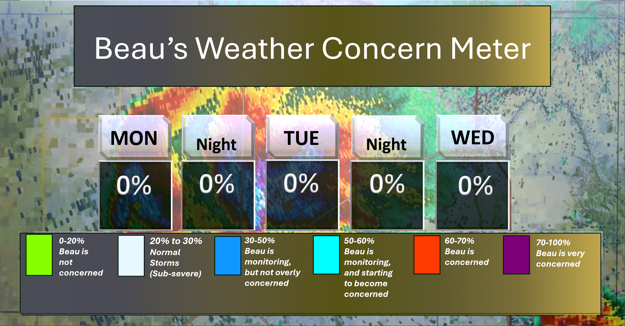
1. Is lightning in the forecast? YES. Lightning is possible late Wednesday night into Friday. Peak chances will be on Thursday into Friday.
2. Are organized/widespread severe thunderstorms in the forecast? MONITOR. I am monitoring Thursday and Friday. Perhaps the peak chances for intense storms will be Thursday night and Friday. Monitor updates.
4. Will non-thunderstorm winds top 40 mph? NO.
5. Will the temperature fall below 20 degrees? NO.
6. Is the wind chill forecast to drop below ten degrees? NO.
Here is the short-range thunderstorm concern meter.
.
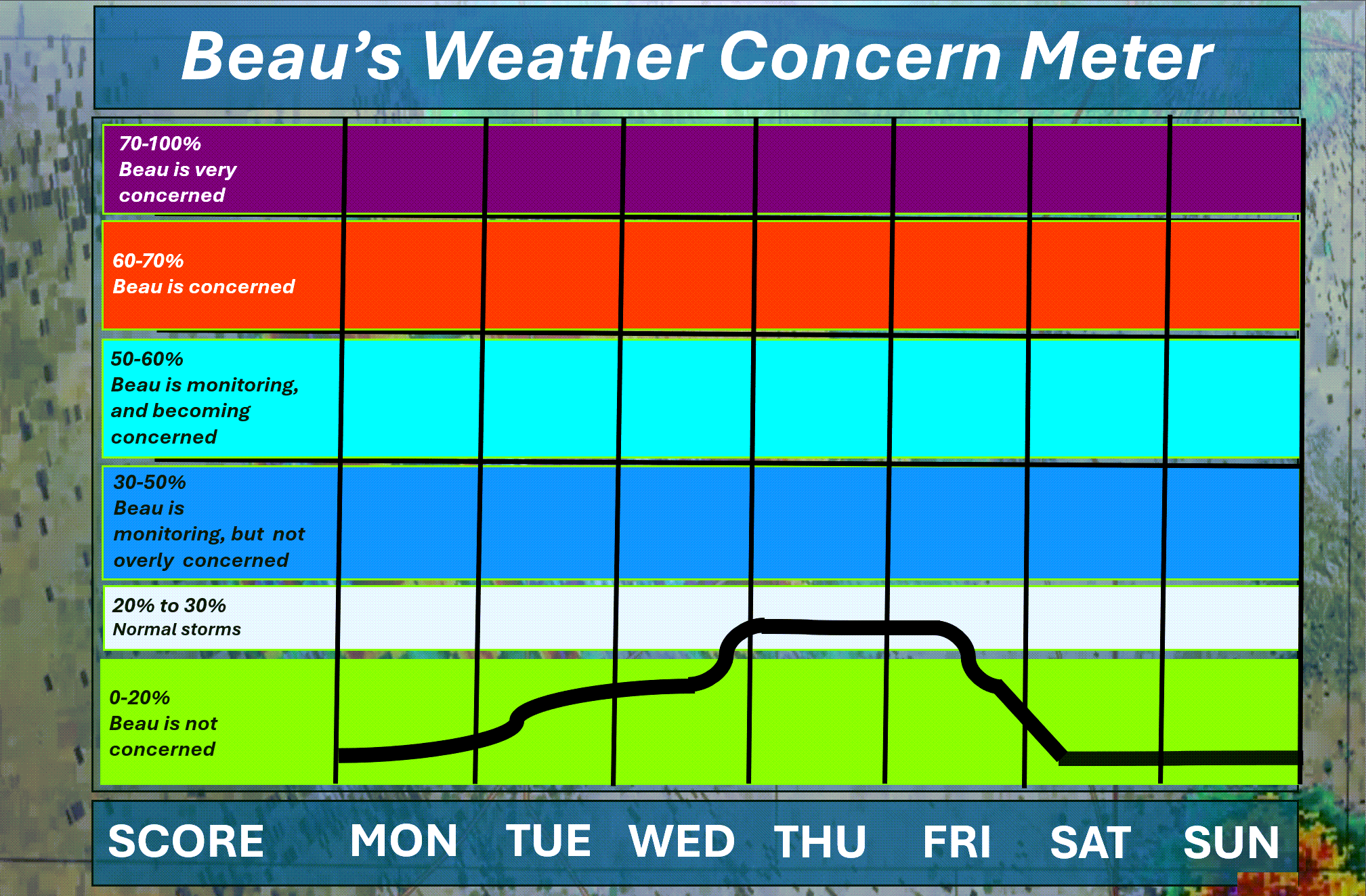
Here is the extended concern meter.
I am watching for the risk of lightning from Wednesday night into Friday.
I am mainly watching Thursday into Friday for a few stronger storms.
It is still too early to know if severe weather will be a concern. Monitor updates.
.
A quick forecast glance. Your 48-hour forecast Graphics


.
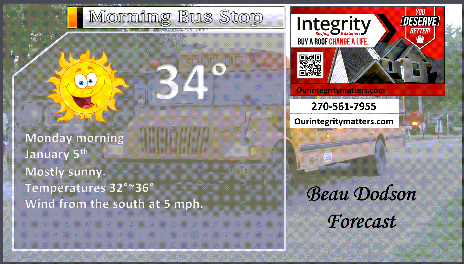
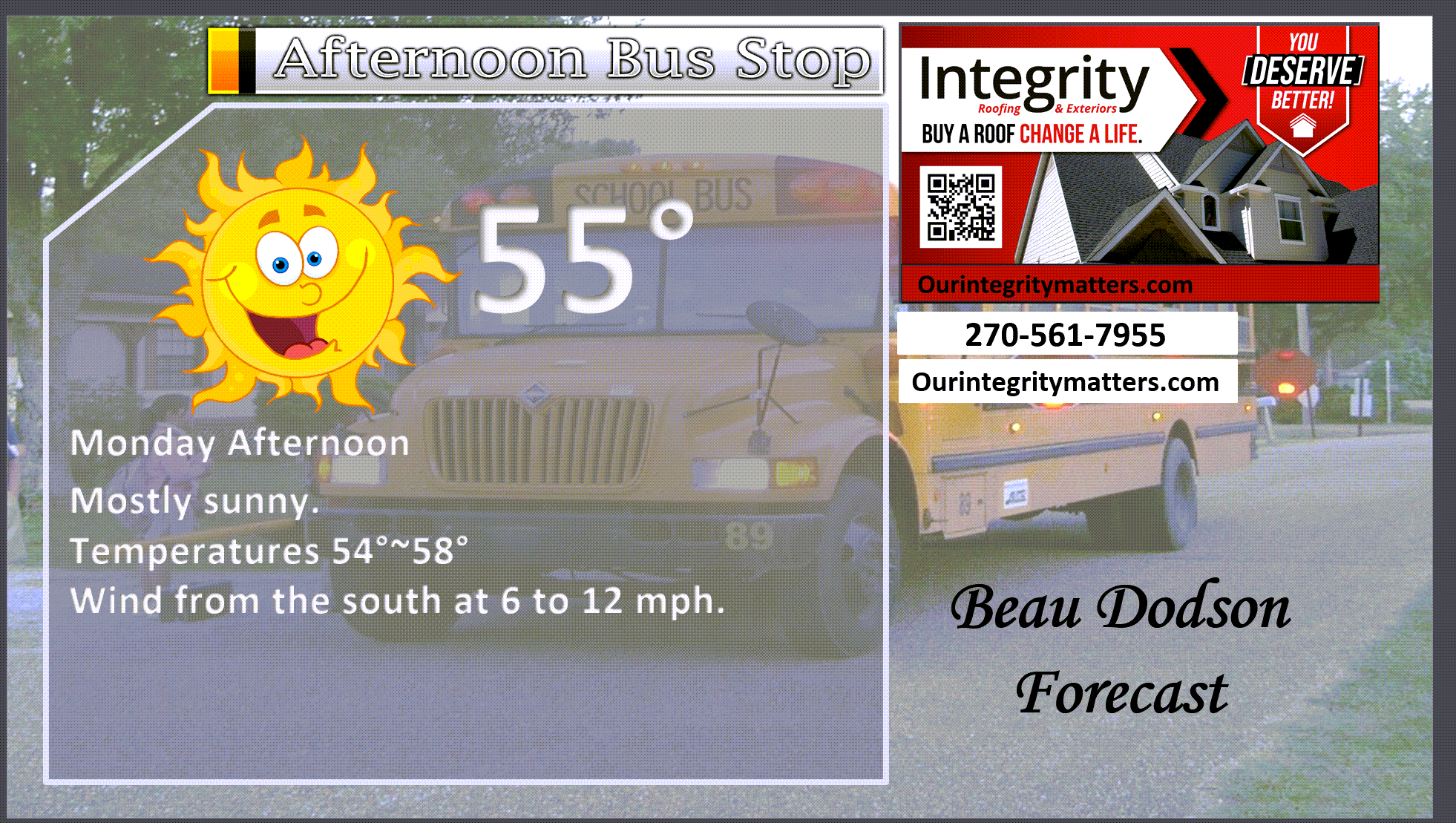
Here is your bus stop forecast
.
This afternoon
.


Forecast discussion
- Calm weather through Wednesday afternoon.
- A warming trend over the coming days.
- Showers and thunderstorms return to the forecast on Wednesday night. Rain will linger into at least Friday. A few thunderstorms are possible.
- It is still too early to know if severe weather will be a concern.
- Cooler temperatures will arrive on Saturday and Sunday. A few showers may linger into Saturday.
.
 .
.
.
What is the primary weather concern?
The primary weather concern will be showers and thunderstorms from Wednesday night into Friday.
I am monitoring the risk of a few strong thunderstorms. See the SPC graphic below. Monitor updates.
.
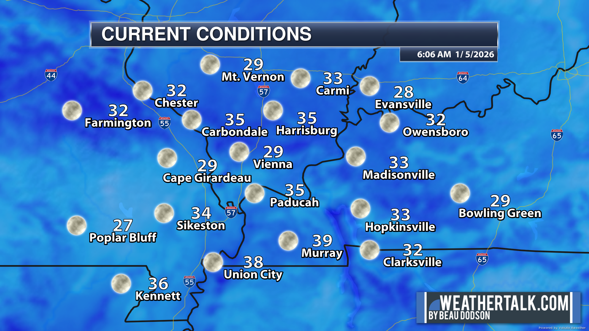
Here were the 6 AM temperatures.
We are waking up to chilly temperatures.
.
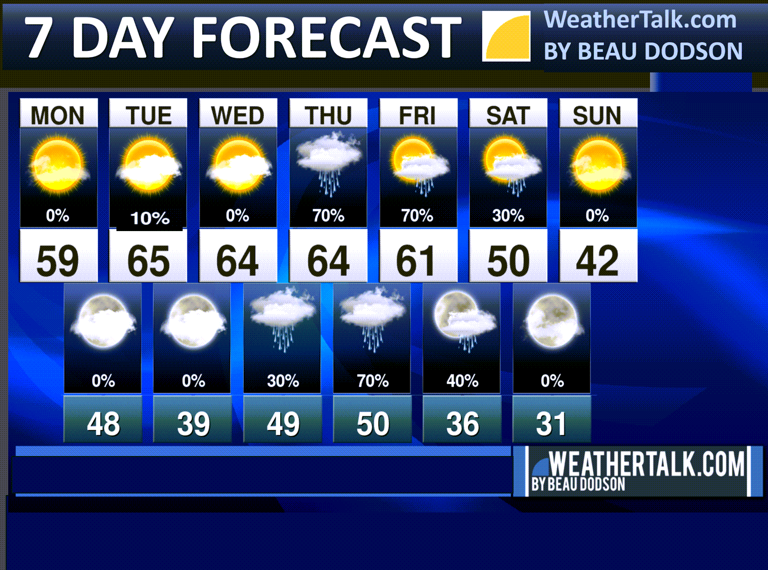
Seven-day outlook graphic.
See the video or graphics below for more details specific to your county. This is a broad-brush overview of the entire region.
.
Today through Wednesday afternoon
There are no significant weather concerns through Wednesday afternoon.
A weak front will move through the region tomorrow. I did include a 10% to 20% chance of showers across the eastern portions of western Kentucky. Mainly the Pennyrile area. Most areas will remain dry.
The good news is that temperatures will be mild this week.
Let’s take a look at that!
Monday’s high temperatures
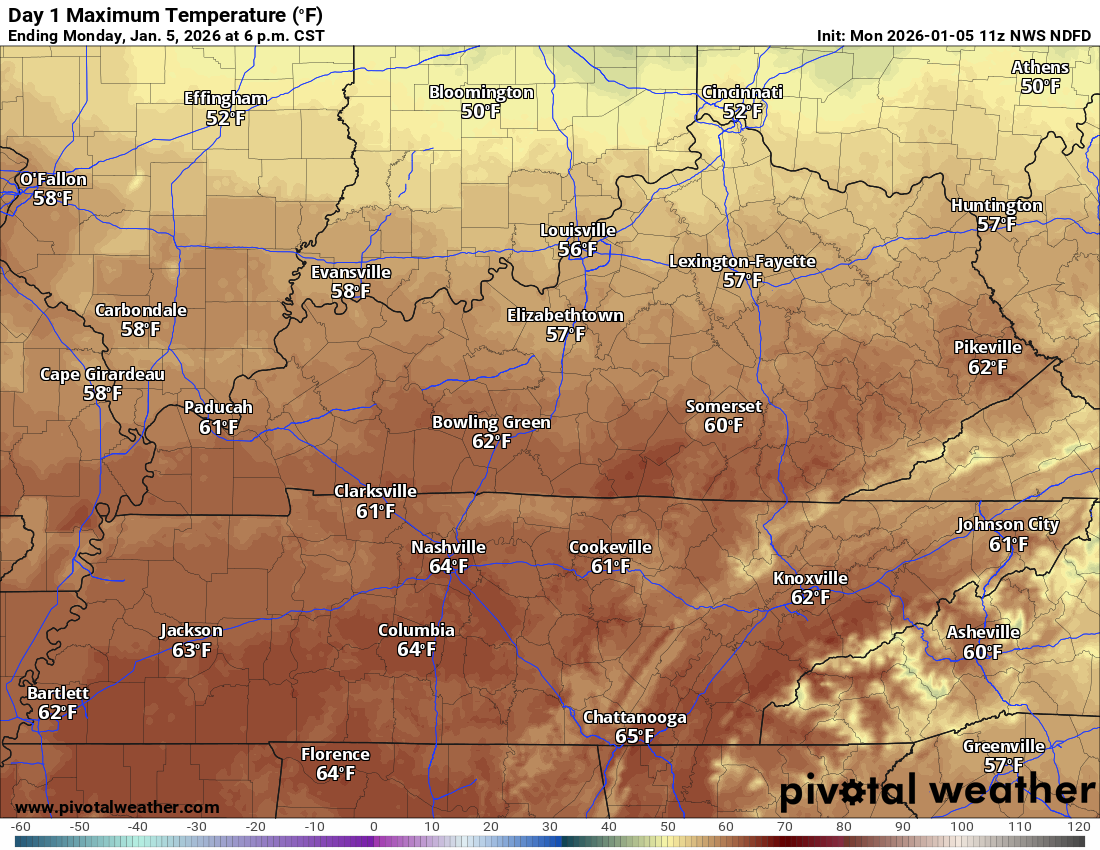
.
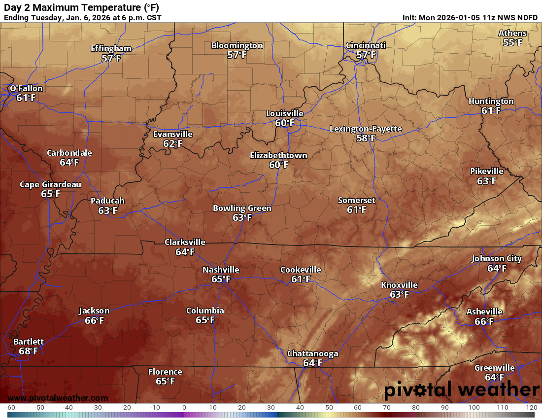
Tuesday’s high temperatures
.
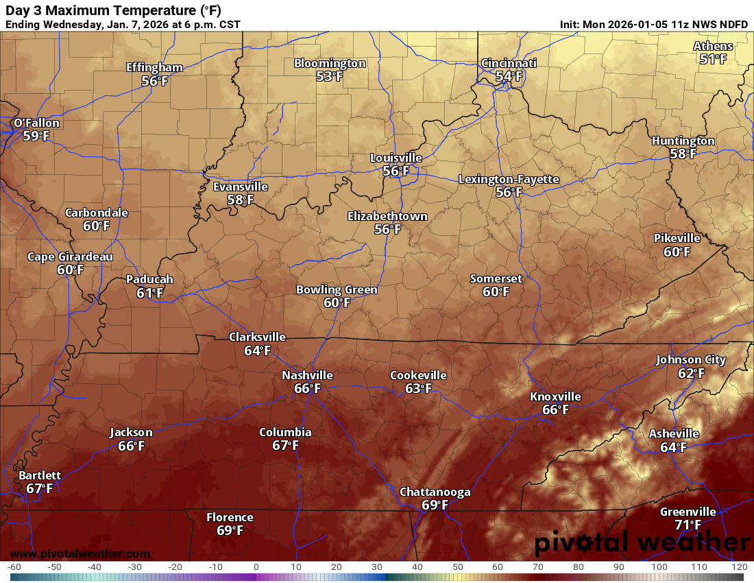
Wednesday’s high temperatures
.
Wednesday night through Sunday
Thursday will be mild. Perhaps Friday, as well.
These warm temperatures will precede a strong cold front arriving on Thursday and Friday.
It now appears that the frontal passage will wait until Friday. A lot of the data has slowed the arrival time.
Sorry, snow fans. This is not your weather.
Thursday’s highs

.
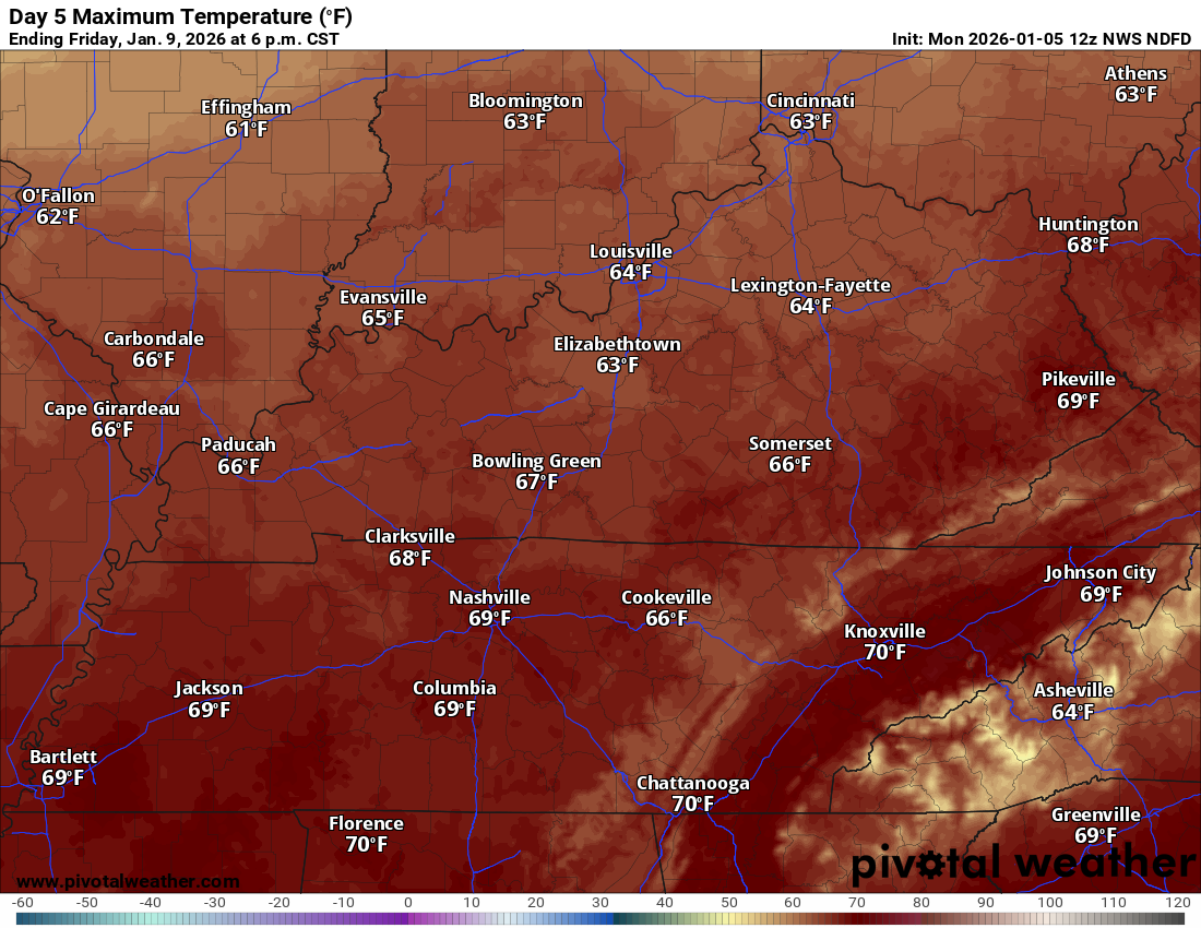
Friday’s highs
.
It will turn cooler by Saturday and Sunday.
Saturday’s high temperatures

.
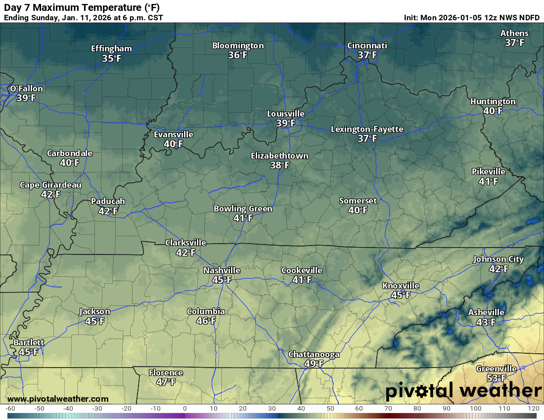
Sunday’s high temperatures
.
A strong cold front will bring showers and thunderstorms back to the region by Wednesday night and Thursday.
The showers and thunderstorms will linger into Friday.
I will monitor Friday night and Saturday. I can’t rule out some showers lingering a bit longer. This will depend heavily on how quickly the cold front passes through our region.
Showers and thunderstorms will accompany the front.
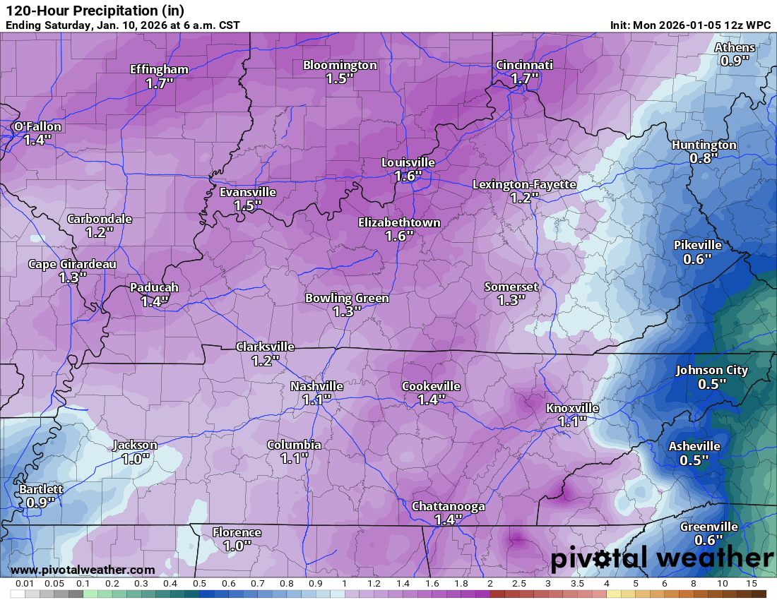
Rainfall totals of 0.60″ to 1.20″ are anticipated. Locally higher totals are possible.
The latest NOAA/NWS rainfall outlook shows over an inch.
A safe forecast is 0.60″ to 1.20″. I will monitor trends over the coming days. The system is still off the West Coast.
Most of this will fall on Thursday into Friday.
.
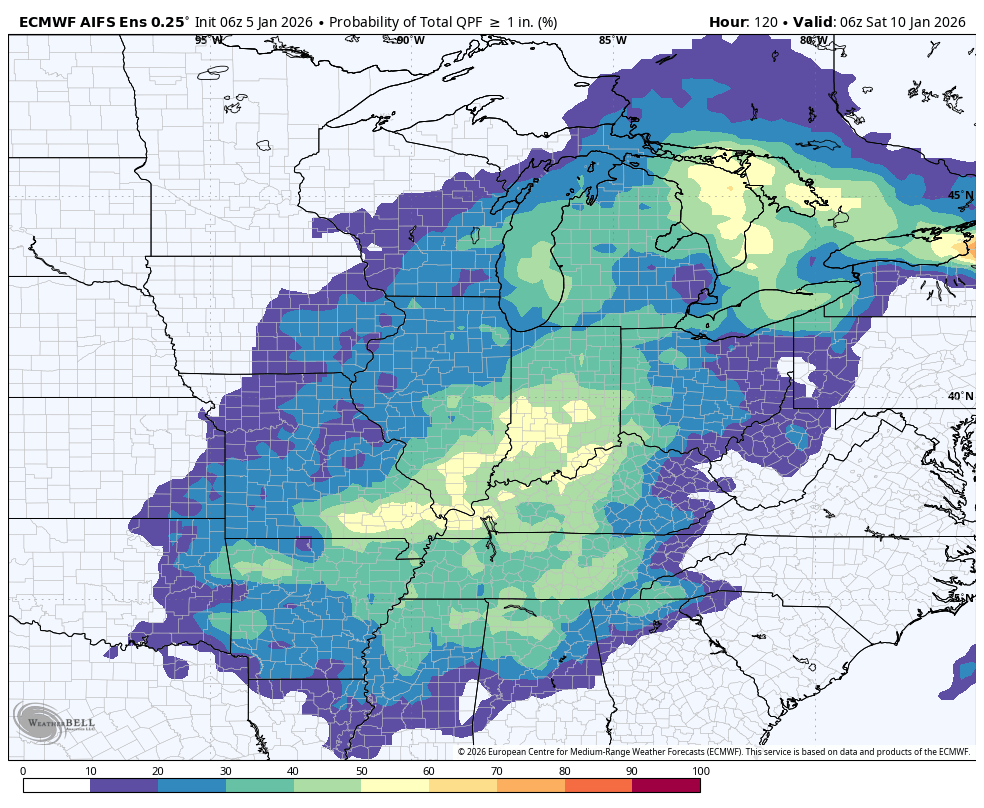
Here is the EC ensemble mean. What is the % chance of an inch or more of rain?
This would be late Wednesday night into Friday night. We need this rain.
.
Severe weather concerns?
Wind shear will be high, as is usually the case during the winter months.
Wind shear is an increase in wind speed with height. Wind shear is the turning of the wind direction with height.
Wind shear is one ingredient for thunderstorms to become severe.
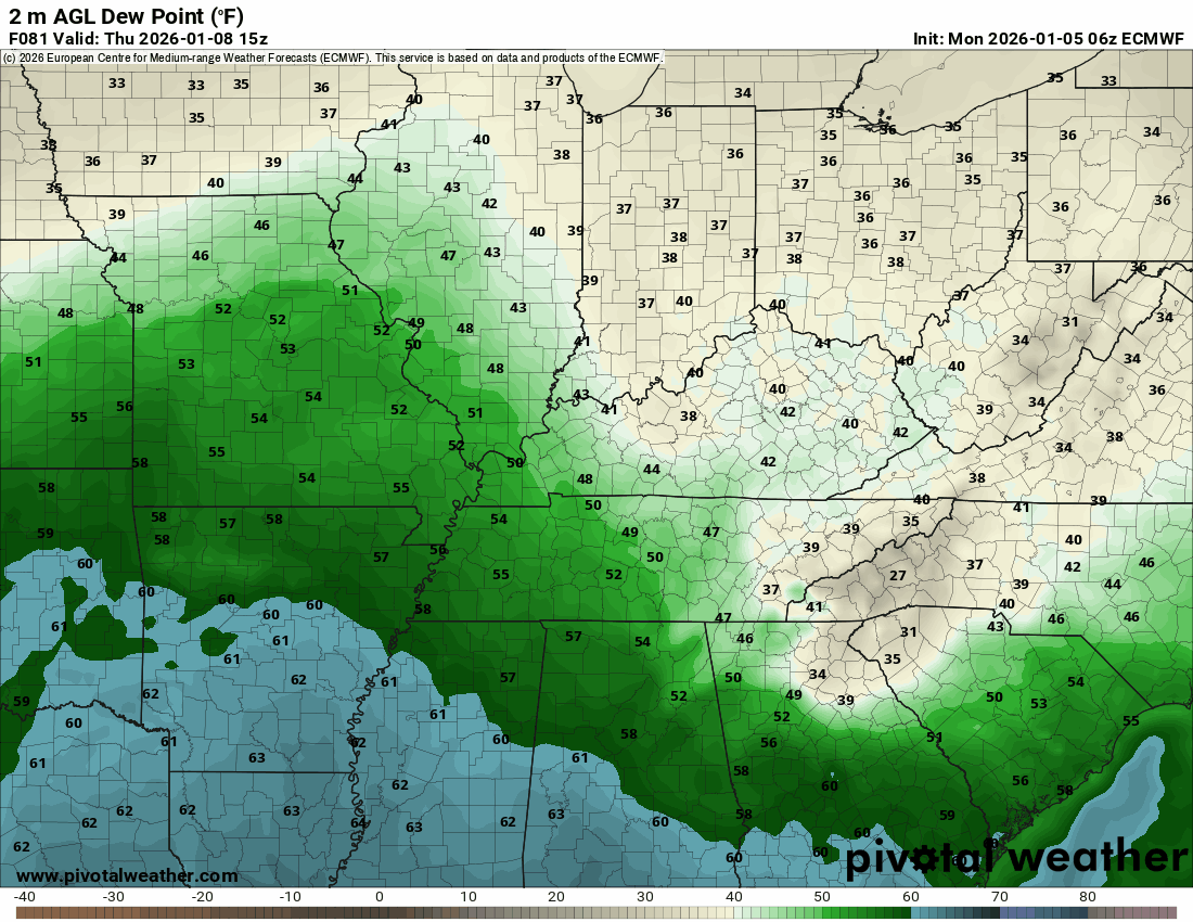
Dew points will range from the upper 50s to the lower 60s. That is a sufficient amount of moisture for severe weather. Typically, during January, I look for dew points ranging from 58 to 62+.
Dew point is a measure of moisture.
Here is the EC model. These are dew points. The blue colors represent dew points in the sixties.
The timestamp is located in the upper-left portion of the animated graphic.
.
The lacking ingredient for a severe weather outbreak is CAPE. That is typically the case during January. High wind shear and little CAPE.
CAPE is energy that thunderstorms tap into. CAPE is what fuels severe weather.
Without CAPE, there won’t be severe thunderstorms.
With that said, I am monitoring trends in the guidance. If CAPE ends up a bit higher, then we will need to be concerned about a few thunderstorms becoming severe.
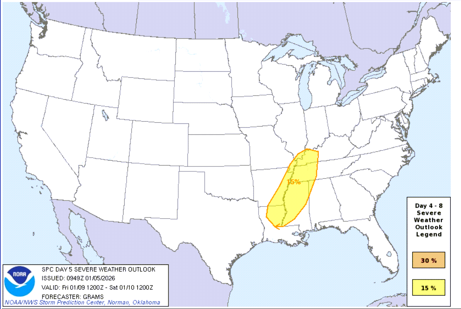
The Storm Prediction Center has highlighted the area in yellow for a risk of severe storms on Friday.
Let’s keep an eye on Thursday and Thursday night, as well.
Undoubtedly, this highlighted area will move around over the coming days. It usually does.
The yellow zone is the area they are most concerned about. They stated, however, that confidence in severe weather remains low. There are questions about instability (as I mentioned above).
Here is the Storm Prediction Center’s severe weather outlook for Friday. I am also watching Thursday and Thursday night.
.
For now, it is just too soon to get overly worked up about it. I am closely monitoring it and will know more tomorrow and Wednedsay. Monitor updates over the coming days. I will send app alerts if a severe weather risk materializes.
.
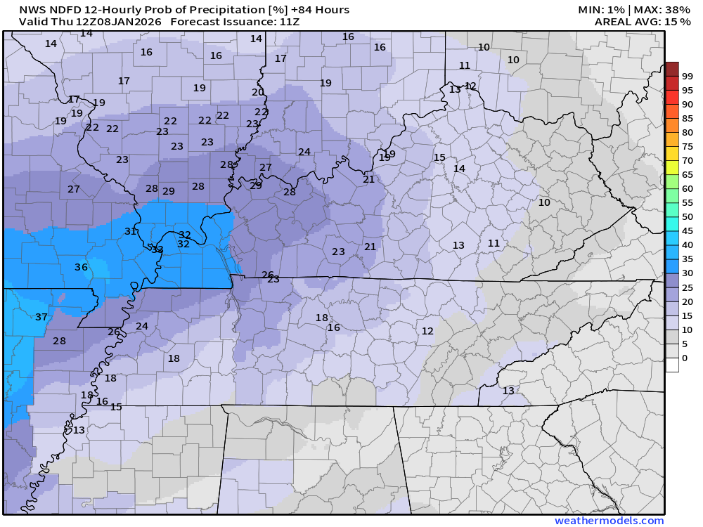
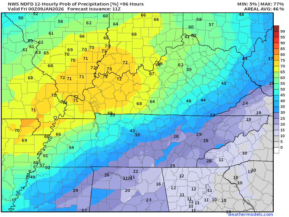
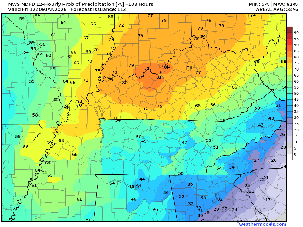
Let’s look at the rain probabilities.
What is the % chance of rain?
Wednesday night
.
Thursday
.
Thursday night
.
Friday
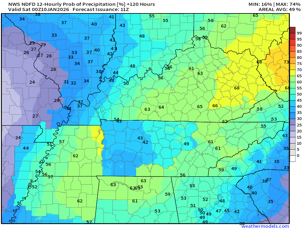
.
Friday night
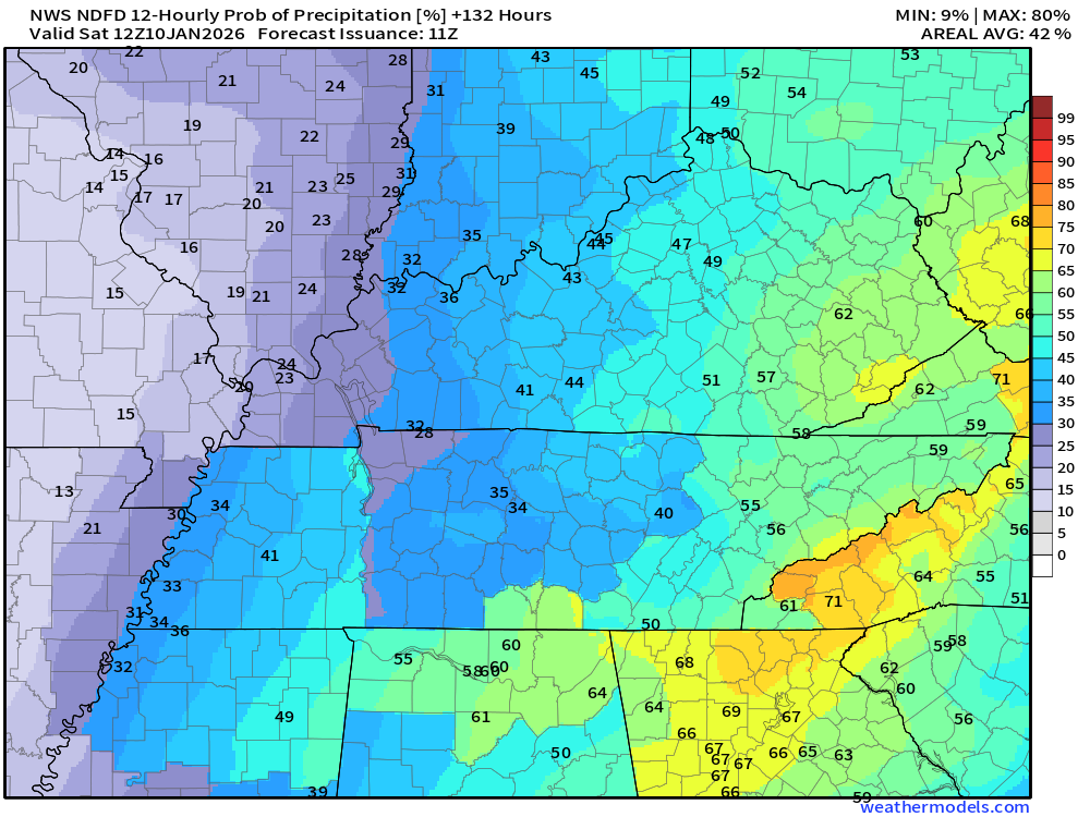
.
It will turn colder by Saturday and Sunday.
At this time, we do not have snow or ice in the forecast. Our snow season has about 9 or 10 weeks left. Beyond mid-March, it becomes more challenging to receive significant snowfall. Not impossible, but it certainly is more difficult and quickly melts.
.

.
The timestamp (upper left) is in Zulu. 12z=6 am. 18z=12 pm. 00z=6 pm.
Double-click the animation to enlarge it.
Green is rain. Yellow is moderate rain. Blue is snow.
GFS model
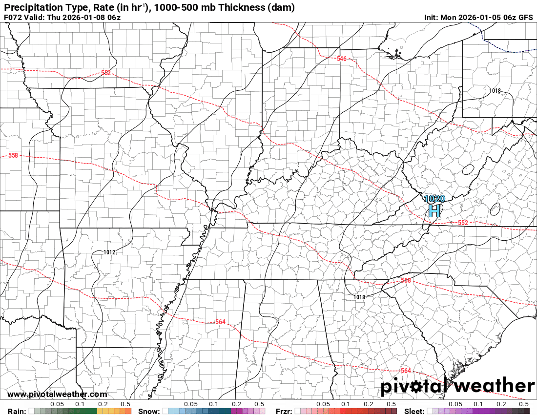
.
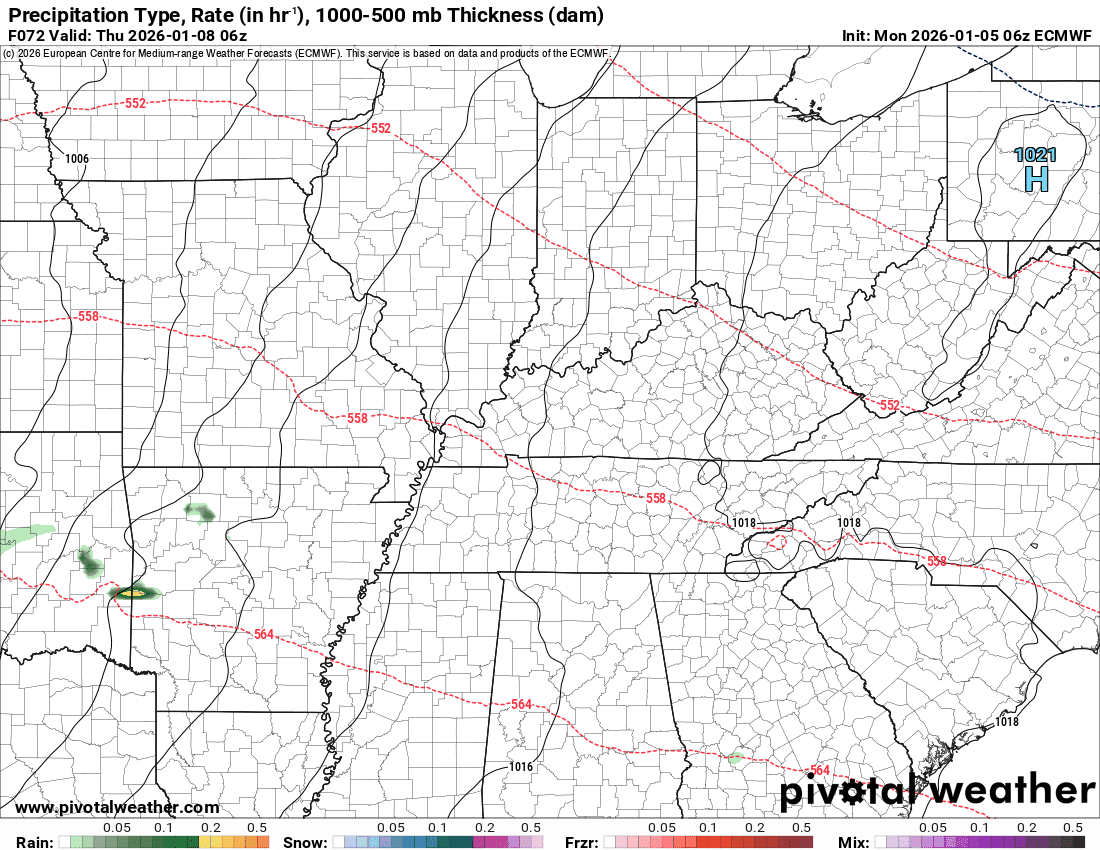
The timestamp (upper left) is in Zulu. 12z=6 am. 18z=12 pm. 00z=6 pm.
Double-click the animation to enlarge it.
Green is rain. Yellow is moderate rain. Blue is snow.
EC model
.
.
..
.
Click here if you would like to return to the top of the page.
.Average high temperatures for this time of the year are around 44 degrees.
Average low temperatures for this time of the year are around 28 degrees.
Average precipitation during this time period ranges from 1.00″ to 1.25″
Six to Ten Day Outlook.
Blue is below average. Red is above average. The no color zone represents equal chances.
Average highs for this time of the year are in the lower 60s. Average lows for this time of the year are in the lower 40s.

Green is above average precipitation. Yellow and brown favors below average precipitation. Average precipitation for this time of the year is around one inch per week.

.

Average low temperatures for this time of the year are around 26 degrees.
Average precipitation during this time period ranges from 1.00″ to 1.25″
.
Eight to Fourteen Day Outlook.
Blue is below average. Red is above average. The no color zone represents equal chances.

Green is above average precipitation. Yellow and brown favors below average precipitation. Average precipitation for this time of the year is around one inch per week.

.
.
.
We have a new service to complement your www.weathertalk.com subscription. This does NOTreplace www.weathertalk.com It is simply another tool for you to receive severe weather information.
.
https://weathercallservices.com/beau-dodson-weather


Want to receive the daily forecast/other products on your Beau Dodson Weather app?
Did you know you have four options in your www.weathertalk.com account
You will then receive these via your Beau Dodson Weather app.
Just log into your www.weathertalk.com account
Click the NOTIFICATION SETTINGS TAB
Then, turn them on (green) and off (red)
🌪️ Number 1 is the most important one. Severe alerts, tornado alerts, and so on.
Number 2 is the daily video, blog, livestream alerts, and severe weather Facebook threads on severe days or winter storm days.
Number 3 is the daily forecast. I send that out every day during the afternoon hours. It is the seven-day forecast, hazardous weather outlook, fire outlook, and more.
Number 4 is to receive the daily video, blog, and other content on NON-severe weather days (every day without severe threats in other words)
GREEN IS ON
RED IS OFF

I am going to start going live during bigger severe weather events.
Check it out here https://www.youtube.com/user/beaudodson
Click the subscribe button (it’s a free subscription button), and it will alert you when I go live. I will also send out alerts to the app when I go live for an event.

.

Radars and Lightning Data
Interactive-city-view radars. Clickable watches and warnings.
https://wtalk.co/B3XHASFZ
Old legacy radar site (some of you like it better)
https://weatherobservatory.com/weather-radar.htm
If the radar is not updating then try another one. If a radar does not appear to be refreshing then hit Ctrl F5. You may also try restarting your browser.
Backup radar site in case the above one is not working.
https://weathertalk.com/morani
Regional Radar
https://imagery.weathertalk.com/prx/RadarLoop.mp4
** NEW ** Zoom radar with chaser tracking abilities!
ZoomRadar
If the radar is not working, then email me: Email me at beaudodson@usawx.com
.
We do have some sponsors! Check them out.
Roof damage from recent storms? Link – Click here
INTEGRITY ROOFING AND EXTERIORS!
⛈️ Roof or gutter damage from recent storms? Today’s weather is sponsored by Integrity Roofing. Check out their website at this link https://www.ourintegritymatters.com/

![]()
![]()
![]()
Make sure you have three to five ways of receiving your severe weather information.
Weather Talk is one of those ways! Now, I have another product for you and your family.

.
Want to add more products to your Beau Dodson Weather App?
Receive daily videos, weather blog updates on normal weather days and severe weather and winter storm days, your county by county weather forecast, and more!
Here is how to do add those additional products to your app notification settings!
Here is a video on how to update your Beau Dodson Weather payment.
The app is for subscribers. Subscribe at www.weathertalk.com/welcome then go to your app store and search for WeatherTalk
Subscribers, PLEASE USE THE APP. ATT and Verizon are not reliable during severe weather. They are delaying text messages.
The app is under WeatherTalk in the app store.

Apple users click here

Android users click here
.
Radars and Lightning Data
Interactive-city-view radars. Clickable watches and warnings.
https://wtalk.co/B3XHASFZ
Old legacy radar site (some of you like it better)
https://weatherobservatory.com/weather-radar.htm
If the radar is not updating then try another one. If a radar does not appear to be refreshing then hit Ctrl F5. You may also try restarting your browser.
Backup radar site in case the above one is not working.
https://weathertalk.com/morani
Regional Radar
https://imagery.weathertalk.com/prx/RadarLoop.mp4
** NEW ** Zoom radar with chaser tracking abilities!
ZoomRadar
Lightning Data (zoom in and out of your local area)
https://wtalk.co/WJ3SN5UZ
Not working? Email me at beaudodson@usawx.com
National map of weather watches and warnings. Click here.
Storm Prediction Center. Click here.
Weather Prediction Center. Click here.
.

Live lightning data: Click here.
Real time lightning data (another one) https://map.blitzortung.org/#5.02/37.95/-86.99
Our new Zoom radar with storm chases
.
.

Interactive GOES R satellite. Track clouds. Click here.
GOES 16 slider tool. Click here.
College of DuPage satellites. Click here
.

Here are the latest local river stage forecast numbers Click Here.
Here are the latest lake stage forecast numbers for Kentucky Lake and Lake Barkley Click Here.
.
.
Find Beau on Facebook! Click the banner.


 .
.