We have a few sponsors that are helping cover new technology costs! Check them out.
Heating problems?
One Hour Heating and Air – Click Here

Connected and Protected.
They Specialize in Audio, Video, Networking, Security, Cameras, Electrical, New Construction, Remodels, and retrofitting Jobs. Experience the future of smart living and unmatched security with Connected & Protected Solutions today.
Link – Click here

Roof damage from recent storms? Link – Click here


Click one of the links below to take you directly to that section
![]()
![]()
![]()
![]()
![]()
.

.
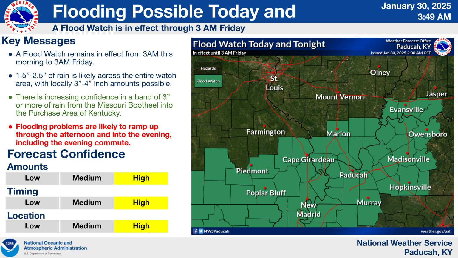
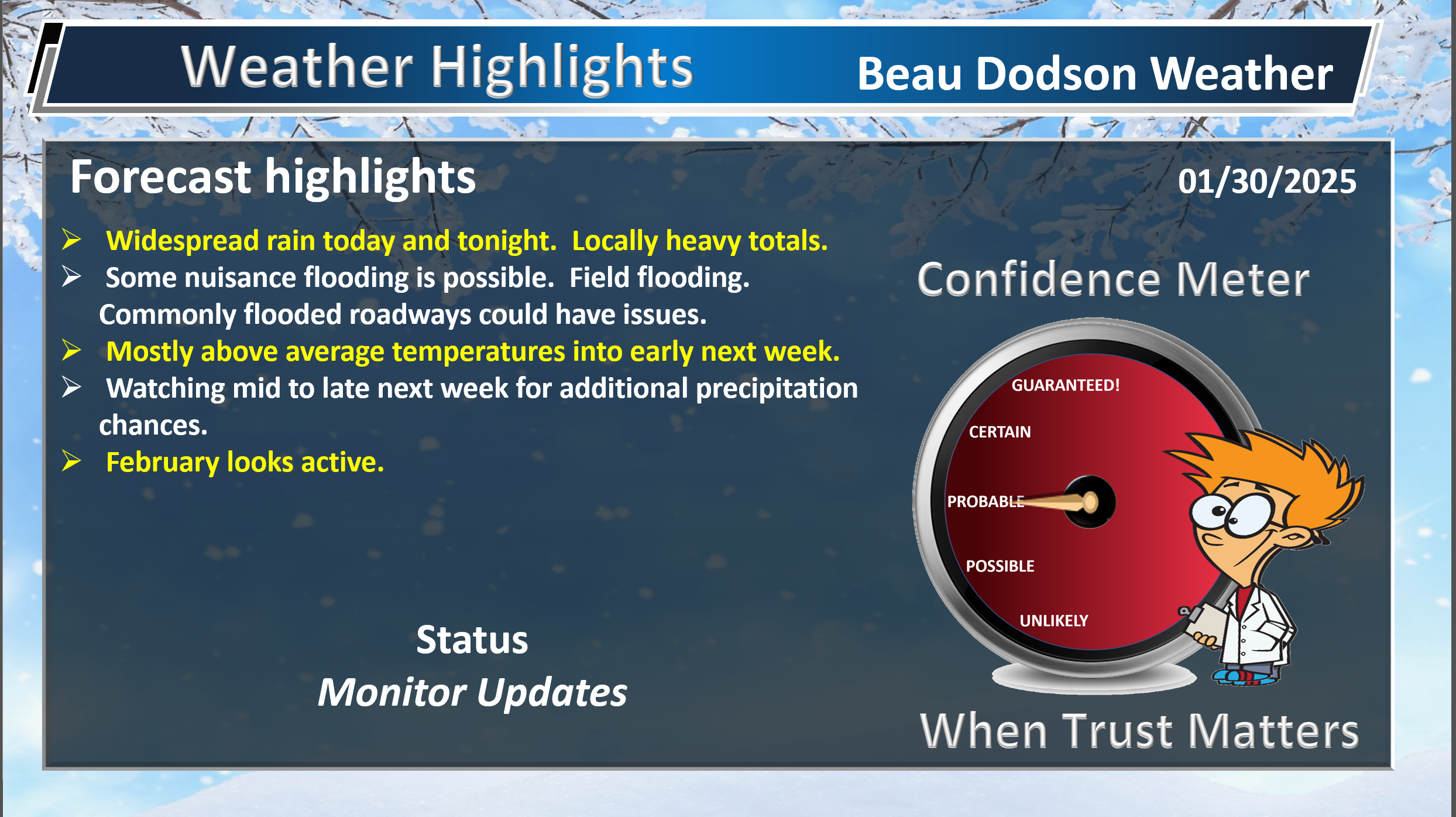
Seven Day Hazardous Weather Outlook
1. Is lightning in the forecast? YES. Today and tonight. A lower chance on Friday late morning and afternoon.
2. Are severe thunderstorms in the forecast? NO.
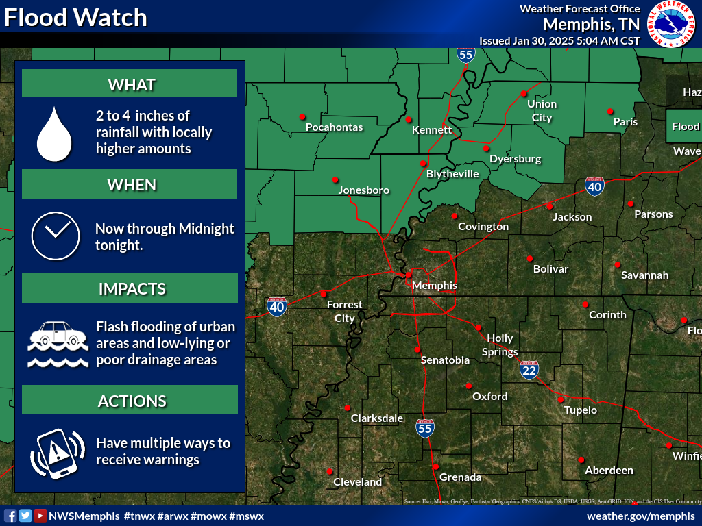
3. Is flash flooding in the forecast? POSSIBLE. Locally heavy rain today and tonight could cause some nuisance flooding issues. Ditches overflowing and field flooding. Commonly flooded roadways could flood. A flood watch covers much of the region.
A flood watch has been issued for most of the area. A few northern counties are not in it.
Double click images to enlarge them.
4. Will non-thunderstorm winds top 40 mph? NO.
6. Will the wind chill dip below 10 degrees? NO.
7. Is measurable snow and/or sleet in the forecast? NO.
8. Is freezing rain in the forecast? NOT AT THIS TIME. I will monitor mid to late next week. For now, it looks like rain, but it could be close.
.

.
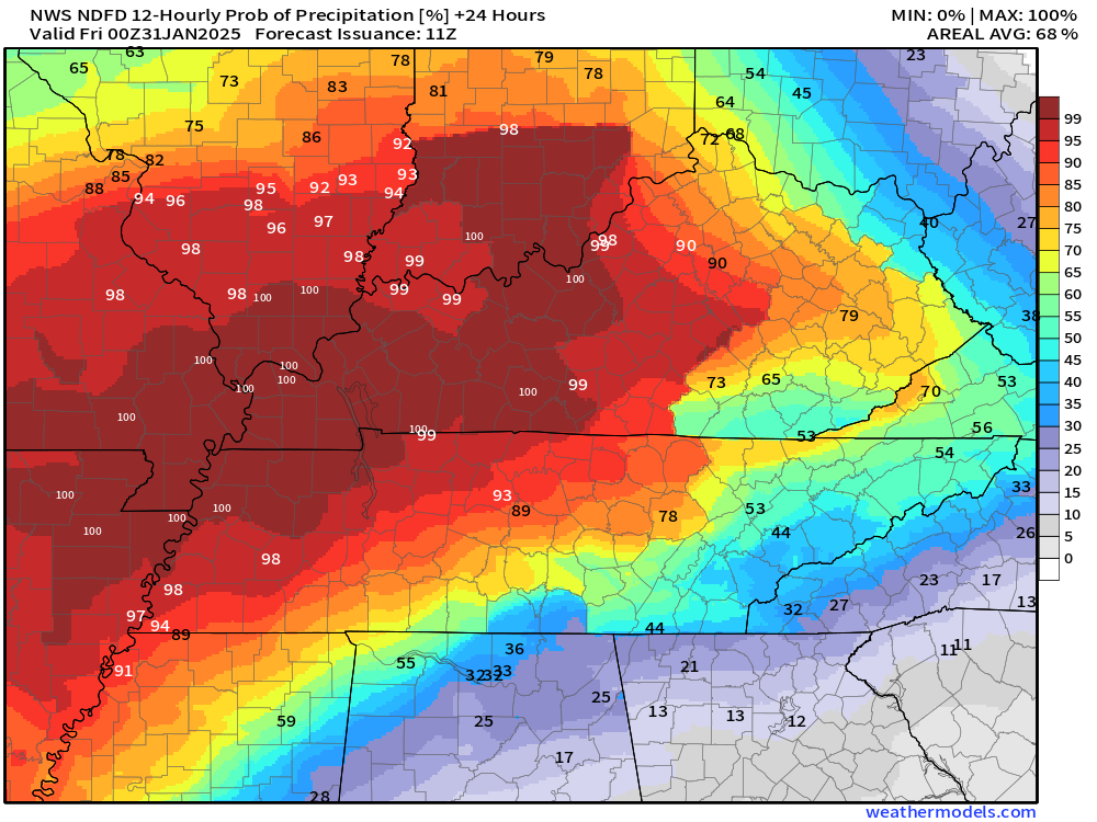
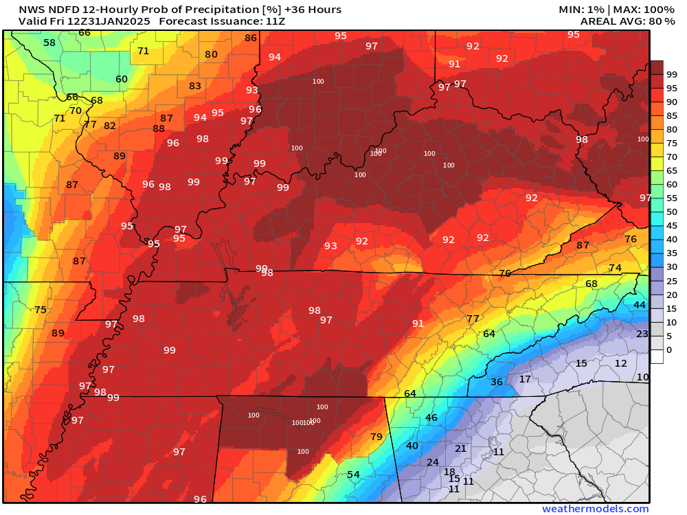
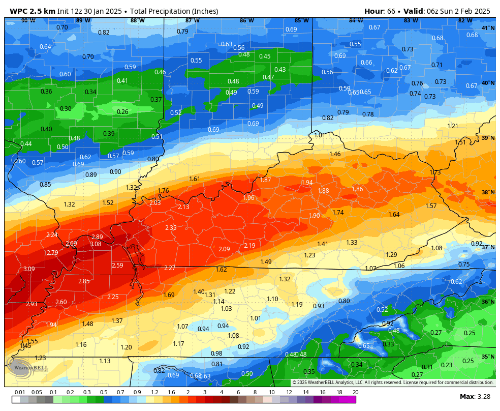
The images below are from NOAA’s Weather Prediction Center.
24-hour precipitation outlook..
 .
.
.
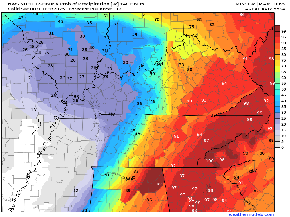
48-hour precipitation outlook.
.
.
Field and Brush Fire weather risk level.
Thursday: 1. Very low risk.
Thursday night: 1. Very low risk.
Friday: 4. Low risk.
Friday night: 4. Low risk.
Fire Weather Discussion
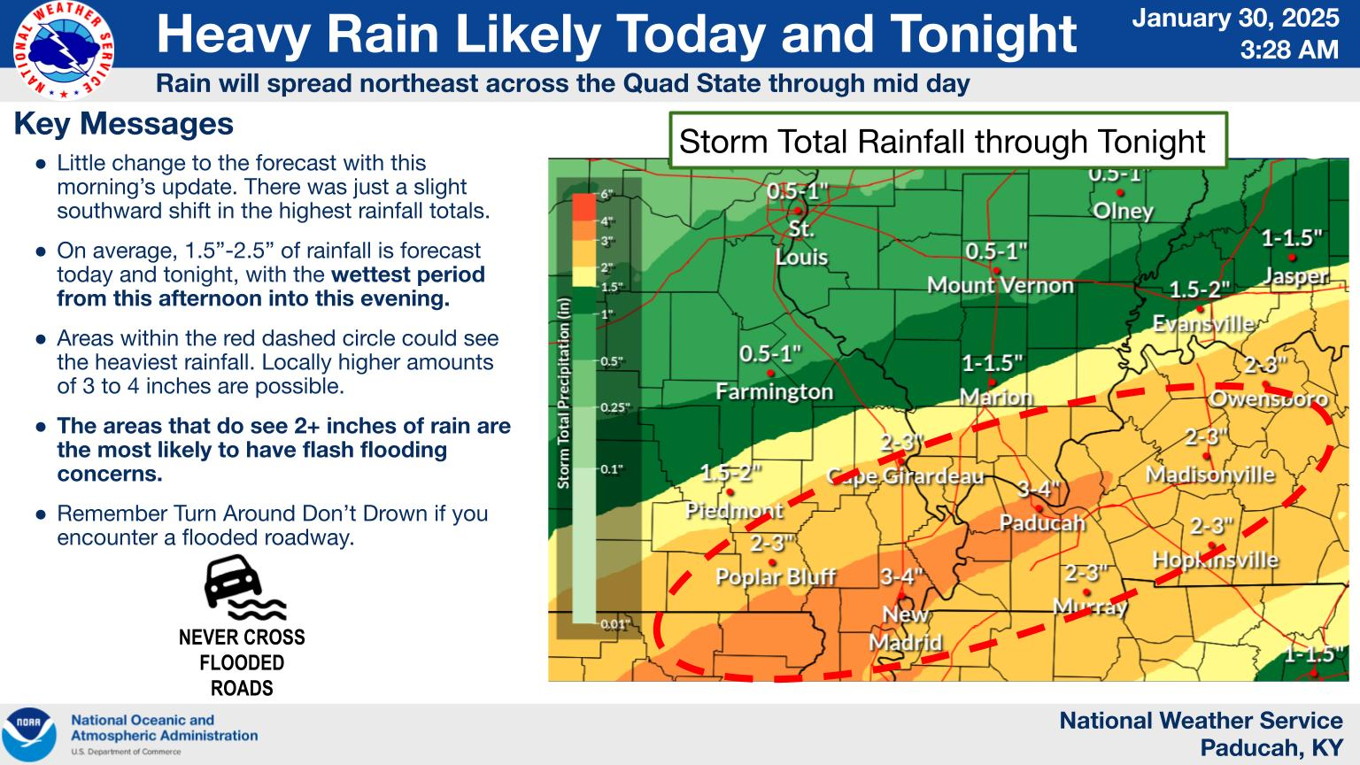
A storm system will bring widespread wetting rains today through tonight across the entire region, followed by scattered chances Friday afternoon. Between 1.5-2.5 inches of rain is likely, with locally 3-4 inches possible across the Missouri Bootheel and Kentucky Purchase. While smoke dispersion today will be poor, mixing heights improve to 3000 ft on Friday with SW transport winds between 10-20 kts.
A Haines Index of 6 means a high potential for an existing fire to become large or exhibit erratic fire behavior, 5 means medium potential, 4 means low potential, and anything less than 4 means very low potential.
.

Notes:
THE FORECAST WILL TO VARY FROM LOCATION TO LOCATION.
Scroll down to see your local forecast details.
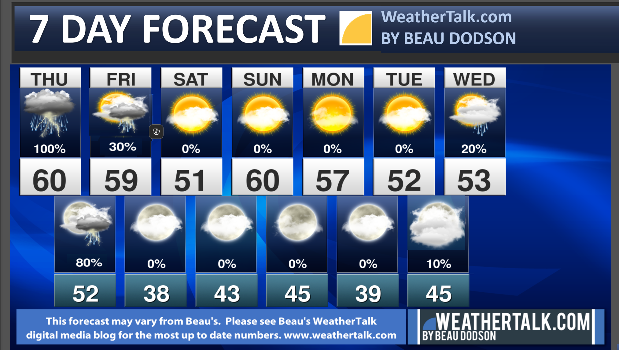
Seven-day forecast for southeast Missouri, southern Illinois, western Kentucky, and western Tennessee.
This is a BLEND for the region. Scroll further down to see the region by region forecast.
Beau’s Seven Day Video Outlook
.
A quick glance. 48-hour forecast Graphics


![]()
.
Thursday Forecast: Widespread rain developing from southwest to northeast. A chance of a thunderstorm.
What is the chance of precipitation?
Far northern southeast Missouri ~ 90%
Southeast Missouri ~ 100%
The Missouri Bootheel ~ 100%
I-64 Corridor of southern Illinois ~ 90%
Southern Illinois ~ 100%
Extreme southern Illinois (southern seven counties) ~ 100%
Far western Kentucky (Purchase area) ~ 100%
The Pennyrile area of western KY ~ 100%
Northwest Kentucky (near Indiana border) ~ 80%
Northwest Tennessee ~ 100%
Coverage of precipitation: Widespread
Timing of the precipitation: Any given point of time.
Temperature range:
Far northern southeast Missouri 52° to 55°
Southeast Missouri 52° to 55°
The Missouri Bootheel 58° to 62°
I-64 Corridor of southern Illinois 52° to 54°
Southern Illinois 52° to 54°
Extreme southern Illinois (southern seven counties) 54° to 58°
Far western Kentucky 54° to 58°
The Pennyrile area of western KY 54° to 58°
Northwest Kentucky (near Indiana border) 52° to 55°
Northwest Tennessee 58° to 62°
Winds will be from this direction: Southeast 10 to 20 mph
Wind chill or heat index (feels like) temperature forecast: 40° to 50° during the morning. In the 50s during the afternoon.
What impacts are anticipated from the weather? Wet roadways. Lightning. Locally heavy rain. Some low-end flooding issues possible. Pea size hail.
Should I cancel my outdoor plans? Have a plan B and monitor the Beau Dodson Weather Radars.
UV Index: 2. Low
Sunrise: 7:00 AM
Sunset: 5:18 PM
.
Thursday Night Forecast: Cloudy. Showers and thunderstorms likely.
What is the chance of precipitation?
Far northern southeast Missouri ~ 80%
Southeast Missouri ~ 80%
The Missouri Bootheel ~ 90%
I-64 Corridor of southern Illinois ~ 90%
Southern Illinois ~ 100%
Extreme southern Illinois (southern seven counties) ~ 100%
Far western Kentucky (Purchase area) ~ 100%
The Pennyrile area of western KY ~ 100%
Northwest Kentucky (near Indiana border) ~ 100%
Northwest Tennessee ~ 100%
Coverage of precipitation: Widespread
Timing of the precipitation: Any given point of time.
Temperature range:
Far northern southeast Missouri 45° to 50°
Southeast Missouri 46° to 50°
The Missouri Bootheel 48° to 50°
I-64 Corridor of southern Illinois 46° to 48°
Southern Illinois 46° to 48°
Extreme southern Illinois (southern seven counties) 48° to 50°
Far western Kentucky 48° to 50°
The Pennyrile area of western KY 48° to 50°
Northwest Kentucky (near Indiana border) 48° to 50°
Northwest Tennessee 50° to 52°
Winds will be from this direction: South southeast at 10 to 20 mph.
Wind chill or heat index (feels like) temperature forecast: 35° to 45°
What impacts are anticipated from the weather? Wet roadways. Lightning possible. Locally heavy rain.
Should I cancel my outdoor plans? Have a plan B and monitor the Beau Dodson Weather Radars
Moonrise: 7:58 AM
Moonset: 6:47 PM
The phase of the moon: Waxing Crescent
.
Friday Forecast: A few remaining showers. A thunderstorm will be possible. Some storms could produce small hail.
What is the chance of precipitation?
Far northern southeast Missouri ~ 30%
Southeast Missouri ~ 30%
The Missouri Bootheel ~ 20%
I-64 Corridor of southern Illinois ~ 30%
Southern Illinois ~ 30%
Extreme southern Illinois (southern seven counties) ~ 30%
Far western Kentucky (Purchase area) ~ 30%
The Pennyrile area of western KY ~ 40%
Northwest Kentucky (near Indiana border) ~ 40%
Northwest Tennessee ~ 30%
Coverage of precipitation: Scattered
Timing of the precipitation: Mainly during the morning.
Temperature range:
Far northern southeast Missouri 54° to 56°
Southeast Missouri 54° to 58°
The Missouri Bootheel 58° to 60°
I-64 Corridor of southern Illinois 54° to 56°
Southern Illinois 54° to 58°
Extreme southern Illinois (southern seven counties) 56° to 60°
Far western Kentucky 58° to 62°
The Pennyrile area of western KY 60° to 62°
Northwest Kentucky (near Indiana border) 58° to 60°
Northwest Tennessee 60° to 64°
Winds will be from this direction: West southwest at 10 to 20 mph. Gusty.
Wind chill or heat index (feels like) temperature forecast: 38° to 48° during the morning. In the 50s during the afternoon.
What impacts are anticipated from the weather? Wet roadways. Lightning. Small hail.
Should I cancel my outdoor plans? No, but monitor the Beau Dodson Weather Radars.
UV Index: 3. Moderate.
Sunrise: 6:59 AM
Sunset: 5:19 PM
.
Friday Night Forecast: Partly cloudy.
What is the chance of precipitation?
Far northern southeast Missouri ~ 0%
Southeast Missouri ~ 0%
The Missouri Bootheel ~ 0%
I-64 Corridor of southern Illinois ~ 0%
Southern Illinois ~ 0%
Extreme southern Illinois (southern seven counties) ~ 0%
Far western Kentucky (Purchase area) ~ 0%
The Pennyrile area of western KY ~ 0%
Northwest Kentucky (near Indiana border) ~ 0%
Northwest Tennessee ~ 0%
Coverage of precipitation:
Timing of the precipitation:
Temperature range:
Far northern southeast Missouri 32° to 35°
Southeast Missouri 34° to 38°
The Missouri Bootheel 38° to 42°
I-64 Corridor of southern Illinois 32° to 34°
Southern Illinois 34° to 36°
Extreme southern Illinois (southern seven counties) 38° to 40°
Far western Kentucky 38° to 42°
The Pennyrile area of western KY 38° to 42°
Northwest Kentucky (near Indiana border) 34° to 36°
Northwest Tennessee 38° to 42°
Winds will be from this direction: North northwest 7 to 14 mph
Wind chill or heat index (feels like) temperature forecast: 26° to 36°
What impacts are anticipated from the weather?
Should I cancel my outdoor plans? No
Moonrise: 6:25 AM
Moonset: 8:00 PM
The phase of the moon: Waxing Crescent
.
Saturday Forecast: Partly sunny.
What is the chance of precipitation?
Far northern southeast Missouri ~ 0%
Southeast Missouri ~0%
The Missouri Bootheel ~ 0%
I-64 Corridor of southern Illinois ~ 0%
Southern Illinois ~ 0%
Extreme southern Illinois (southern seven counties) ~ 0%
Far western Kentucky (Purchase area) ~ 0%
The Pennyrile area of western KY ~ 0%
Northwest Kentucky (near Indiana border) ~ 0%
Northwest Tennessee ~ 0%
Coverage of precipitation:
Timing of the precipitation:
Temperature range:
Far northern southeast Missouri 50° to 54°
Southeast Missouri 52° to 54°
The Missouri Bootheel 52° to 54°
I-64 Corridor of southern Illinois 50° to 52°
Southern Illinois 52° to 54°
Extreme southern Illinois (southern seven counties) 52° to 54°
Far western Kentucky 52° to 54°
The Pennyrile area of western KY 52° to 55°
Northwest Kentucky (near Indiana border) 52° to 54°
Northwest Tennessee 52° to 55°
Winds will be from this direction: Southeast 7 to 14 mph.
Wind chill or heat index (feels like) temperature forecast: 35° to 40° during the morning. In the 50s during the afternoon.
What impacts are anticipated from the weather?
Should I cancel my outdoor plans? No
UV Index: 2. Low.
Sunrise: 6:58 AM
Sunset: 5:20 PM
.
Saturday Night Forecast: Partly cloudy.
What is the chance of precipitation?
Far northern southeast Missouri ~ 0%
Southeast Missouri ~ 0%
The Missouri Bootheel ~ 0%
I-64 Corridor of southern Illinois ~ 0%
Southern Illinois ~ 0%
Extreme southern Illinois (southern seven counties) ~ 0%
Far western Kentucky (Purchase area) ~ 0%
The Pennyrile area of western KY ~ 0%
Northwest Kentucky (near Indiana border) ~ 0%
Northwest Tennessee ~ 0%
Coverage of precipitation:
Timing of the precipitation:
Temperature range:
Far northern southeast Missouri 40° to 44°
Southeast Missouri 40° to 44°
The Missouri Bootheel 40° to 44°
I-64 Corridor of southern Illinois 40° to 44°
Southern Illinois 40° to 44°
Extreme southern Illinois (southern seven counties) 40° to 44°
Far western Kentucky 40° to 44°
The Pennyrile area of western KY 40° to 44°
Northwest Kentucky (near Indiana border) 40° to 44°
Northwest Tennessee 40° to 44°
Winds will be from this direction: Southeast at 7 to 14 mph. Gusty.
Wind chill or heat index (feels like) temperature forecast: 35° to 40°
What impacts are anticipated from the weather?
Should I cancel my outdoor plans? No
Moonrise: 8:54 AM
Moonset: 9:11 PM
The phase of the moon: Waxing Crescent
.
Sunday Forecast: Partly sunny.
What is the chance of precipitation?
Far northern southeast Missouri ~ 0%
Southeast Missouri ~0%
The Missouri Bootheel ~ 0%
I-64 Corridor of southern Illinois ~ 0%
Southern Illinois ~ 0%
Extreme southern Illinois (southern seven counties) ~ 0%
Far western Kentucky (Purchase area) ~ 0%
The Pennyrile area of western KY ~ 0%
Northwest Kentucky (near Indiana border) ~ 0%
Northwest Tennessee ~ 0%
Coverage of precipitation:
Timing of the precipitation:
Temperature range:
Far northern southeast Missouri 60° to 64°
Southeast Missouri 60° to 64°
The Missouri Bootheel 62° to 64°
I-64 Corridor of southern Illinois 60° to 64°
Southern Illinois 60° to 64°
Extreme southern Illinois (southern seven counties) 62° to 64°
Far western Kentucky 62° to 64°
The Pennyrile area of western KY 62° to 64°
Northwest Kentucky (near Indiana border) 60° to 64°
Northwest Tennessee 62° to 64°
Winds will be from this direction: South at 10 to 20 mph. Gusty.
Wind chill or heat index (feels like) temperature forecast: 35° to 45° during the morning. In the 50s and 60s during the afternoon.
What impacts are anticipated from the weather?
Should I cancel my outdoor plans? No
UV Index: 3. Moderate
Sunrise: 6:57AM
Sunset: 5:22 PM
.
Sunday Night Forecast: Partly cloudy.
What is the chance of precipitation?
Far northern southeast Missouri ~ 0%
Southeast Missouri ~ 0%
The Missouri Bootheel ~ 0%
I-64 Corridor of southern Illinois ~ 0%
Southern Illinois ~ 0%
Extreme southern Illinois (southern seven counties) ~ 0%
Far western Kentucky (Purchase area) ~ 0%
The Pennyrile area of western KY ~ 0%
Northwest Kentucky (near Indiana border) ~ 0%
Northwest Tennessee ~ 0%
Coverage of precipitation:
Timing of the precipitation:
Temperature range:
Far northern southeast Missouri 40° to 44°
Southeast Missouri 42° to 44°
The Missouri Bootheel 44° to 46°
I-64 Corridor of southern Illinois 40° to 44°
Southern Illinois 42° to 44°
Extreme southern Illinois (southern seven counties) 42° to 45°
Far western Kentucky 42° to 45°
The Pennyrile area of western KY 42° to 45°
Northwest Kentucky (near Indiana border) 42° to 45°
Northwest Tennessee 44° to 46°
Winds will be from this direction: South southwest at 7 to 14 mph.
Wind chill or heat index (feels like) temperature forecast: 34° to 42°
What impacts are anticipated from the weather?
Should I cancel my outdoor plans? No
Moonrise: 9:21 AM
Moonset: 10:22 PM
The phase of the moon: Waxing Crescent
.
Click here if you would like to return to the top of the page.

Do you have any suggestions or comments? Email me at beaudodson@usawx.com
.
Weather Highlights and Forecast Discussion
-
- Widespread rain today and tonight. Embedded thunderstorms.
- Locally heavy rainfall totals. Some nuisance flooding is likely.
- February looks active.
.
Beau’s Forecast Discussion
Radars and Lightning Data
Interactive-city-view radars. Clickable watches and warnings.
https://wtalk.co/B3XHASFZ
Old legacy radar site (some of you like it better)
https://weatherobservatory.com/weather-radar.htm
If the radar is not updating then try another one. If a radar does not appear to be refreshing then hit Ctrl F5. You may also try restarting your browser.
Backup radar site in case the above one is not working.
https://weathertalk.com/morani
Regional Radar
https://imagery.weathertalk.com/prx/RadarLoop.mp4
** NEW ** Zoom radar with chaser tracking abilities!
ZoomRadar
Lightning Data (zoom in and out of your local area)
https://wtalk.co/WJ3SN5UZ
.
Good day everyone,
Our thoughts and prayers to those impacted by the overnight plane crash.
We have widespread rain moving across the region. See the live radar links above.
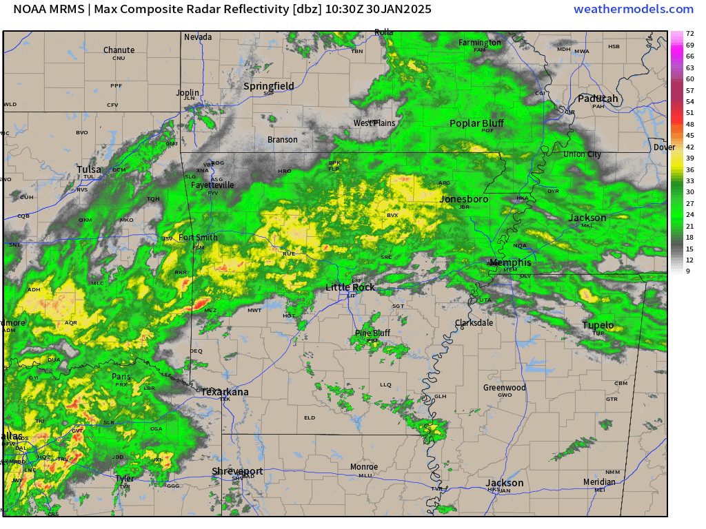
Here is what radar looked like at 6 am. All of this rain was moving northeast.
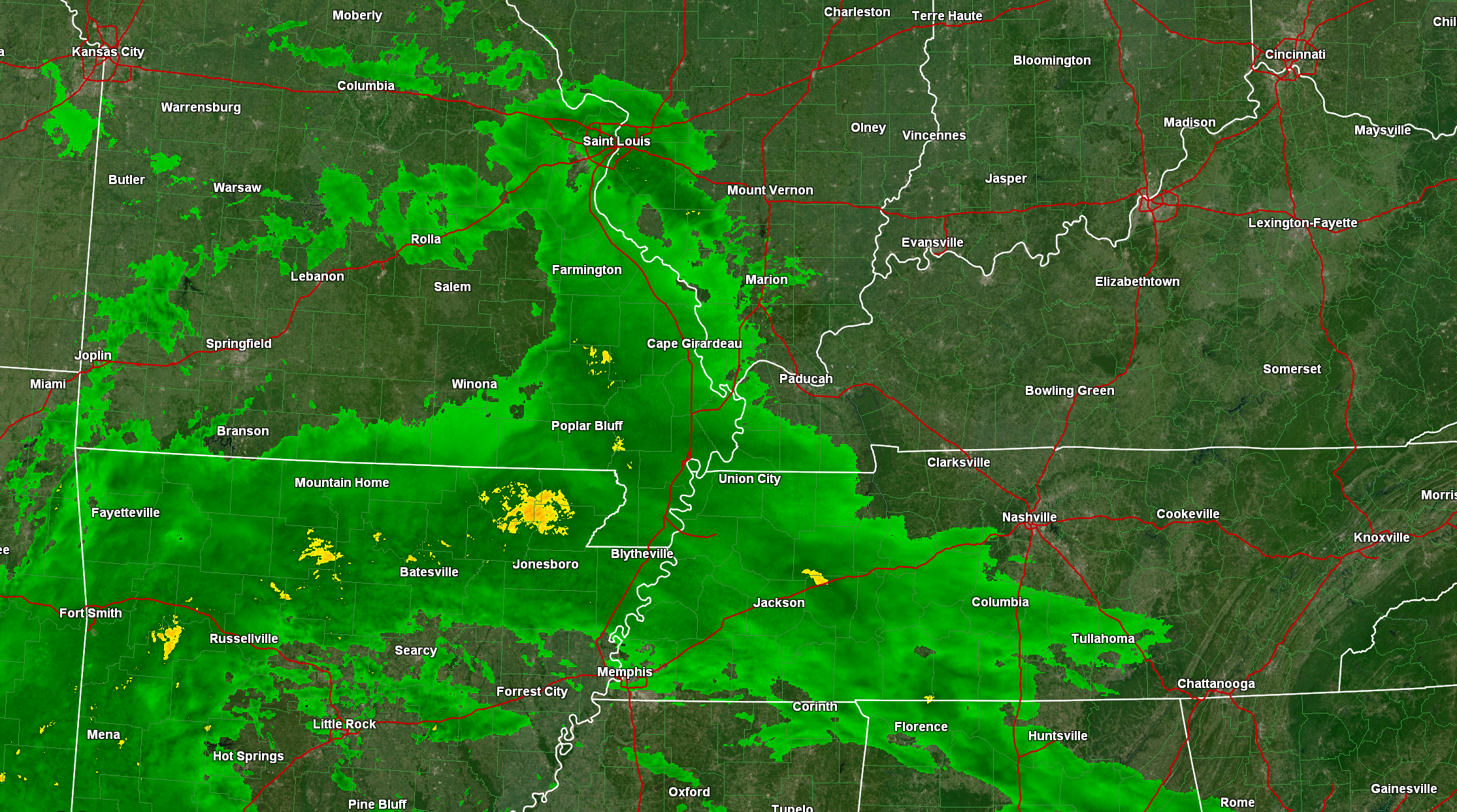
Here was the western view of the 6 am radar. Widespread rain moving into our region.
See live radar above or at the bottom of the blog update.
.
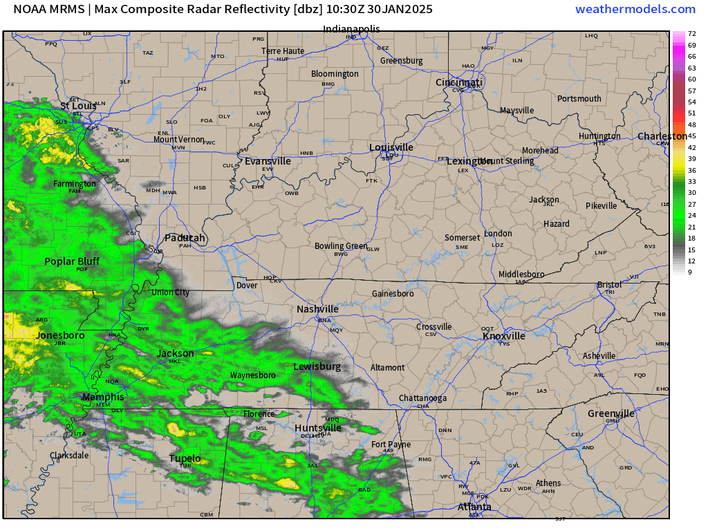
Eastern view of the 6 AM radar.
So, a wet day ahead of us. Wet tonight, as well.
A few thunderstorms will be possible. We do not expect severe weather, but the storms could produce small hail and gusty winds. Lightning, of course.
Locally heavy rain is a concern.
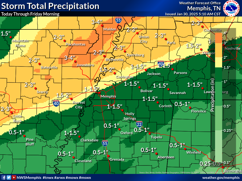
Rain totals will range from one to two inches, area-wide. Then, pockets of two to four inches will be possible.
Here is the latest rainfall outlook.
West view. Double click images and animations to enlarge them.
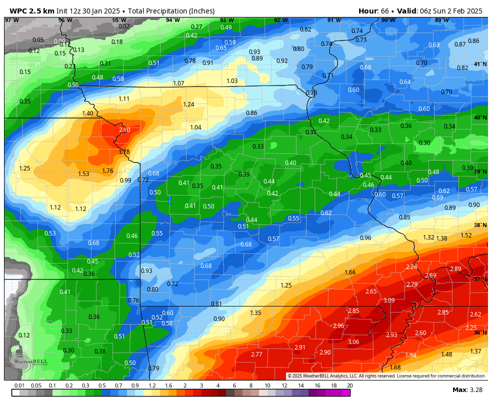
East view
Patchy fog is possible today, as well.
The bulk of the rain will occur today and tonight.
Tomorrow, there will still be some wrap around precipitation as the area of low pressure pulls away from the region.
Most of Friday morning will likely be dry. Then, during the late morning and afternoon hours we will see a few more showers and storms pivot into the region from the west northwest. Moving east southeast.
Some lightning will be possible with that activity. Perhaps some pea size hail, as well.
The region will dry out Friday night. The region will remain dry through Tuesday.
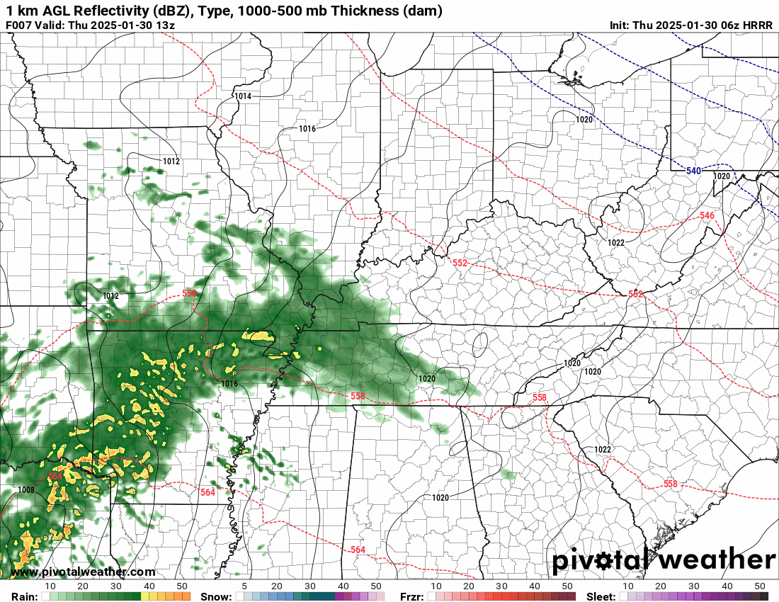
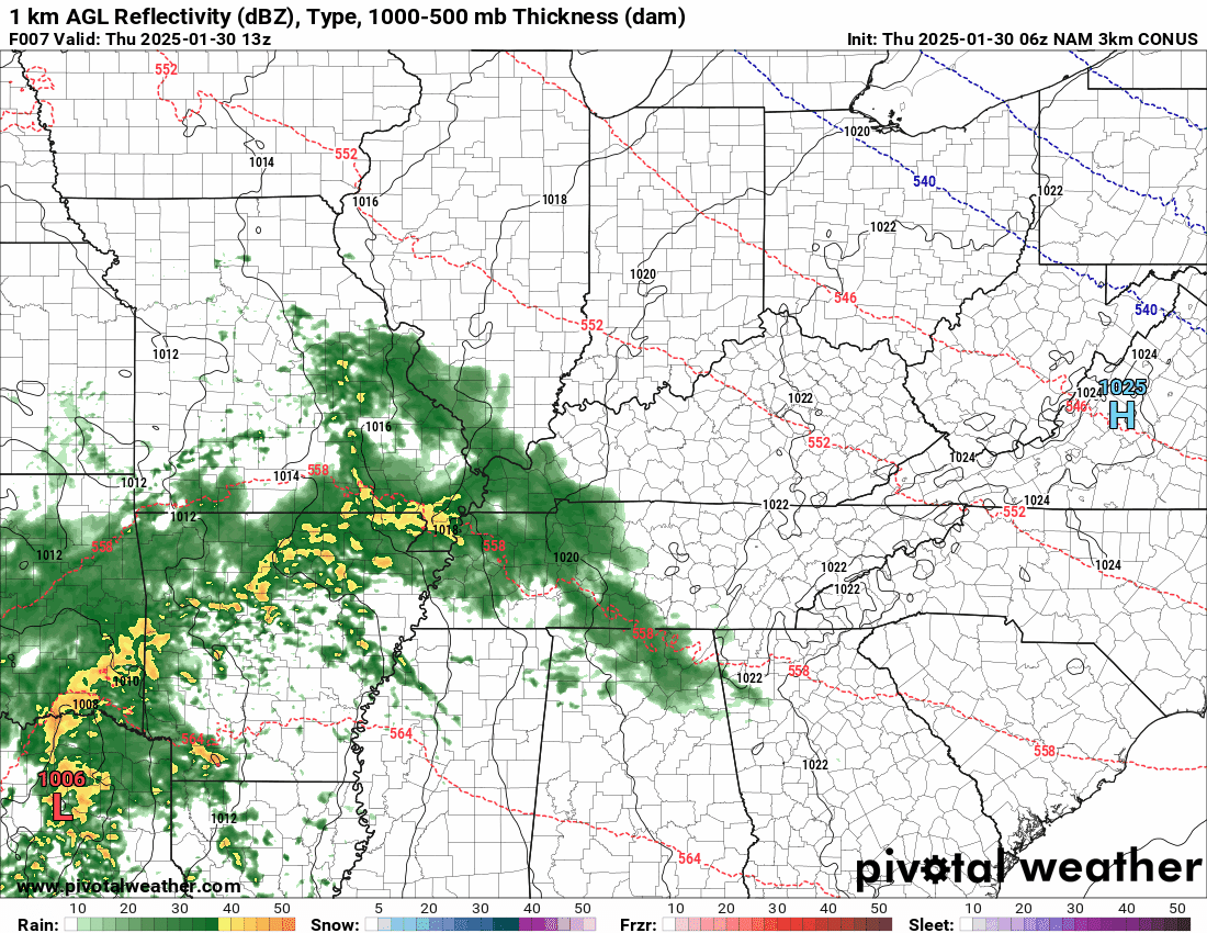
Let’s Look At The Future-cast Radar
Here are the two primary models. This shows you what radar might look like today, tonight, and tomorrow.
Hrrr high-res model
Time stamp is in Zulu. 00z=6 pm. 06z=12 am. 12z=6 am. 18z=12 pm.
.
NAM 3K model shows rain.
Time stamp is in Zulu. 00z=6 pm. 06z=12 am. 12z=6 am. 18z=12 pm.
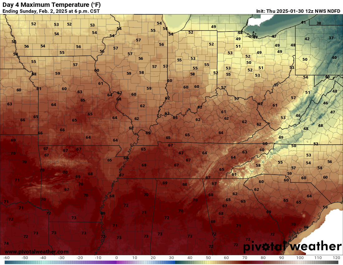
Sunday will be mild. Some locations could hit the sixty degree mark.
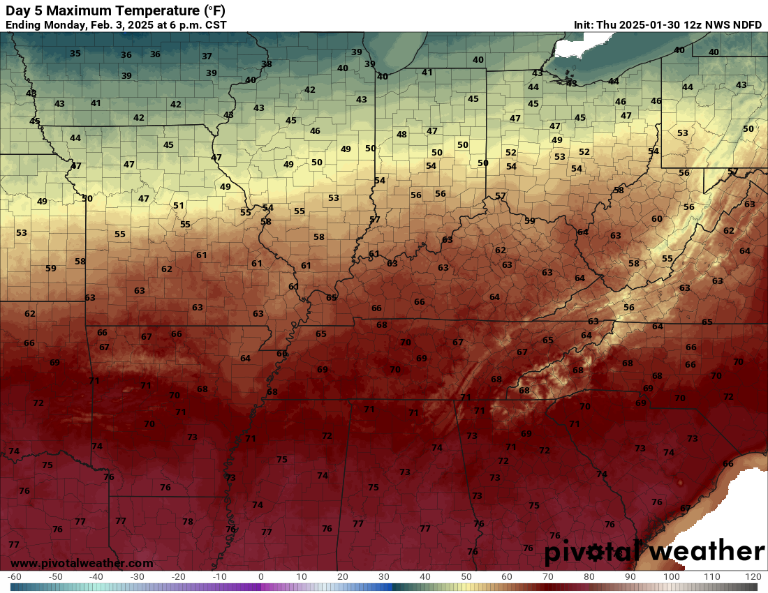
Monday looks nice, as well.
Here is the Sunday high temperature outlook Double click on images to enlarge them.
Here is the Monday high temperature outlook
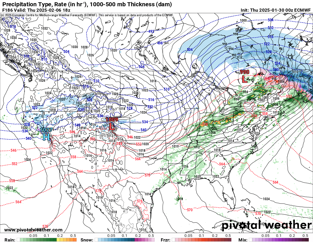
I continue to watch February 5th through the 7th for precipitation. Perhaps another system or two right after that, as well.
Will ie be rain, snow, or ice? That is still a question. A lot of data shows rain, but also has the freezing line just to our north.
We will need to closely monitor that boundary.
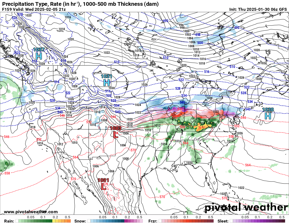
The Canadian model shows a wintry mix and rain. This is next Wednesday night/Thursday.
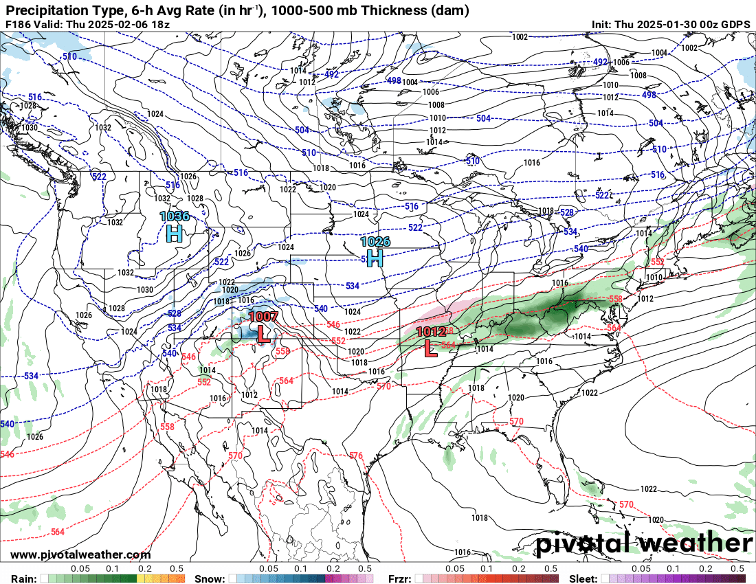
The GFs model shows rain, but the wintry mix is just to our north. This is next Wednesday.
.
The EC model shows mainly rain. This is next Wednesday and Thursday.
.
I continue to watch the cold air well to our north over the next two weeks.
At times, that cold air could ooze its way southward.
Whether we have snow or ice in February remains a question. Models have backed off a bit on the cold air.
I will need to watch trends for now.
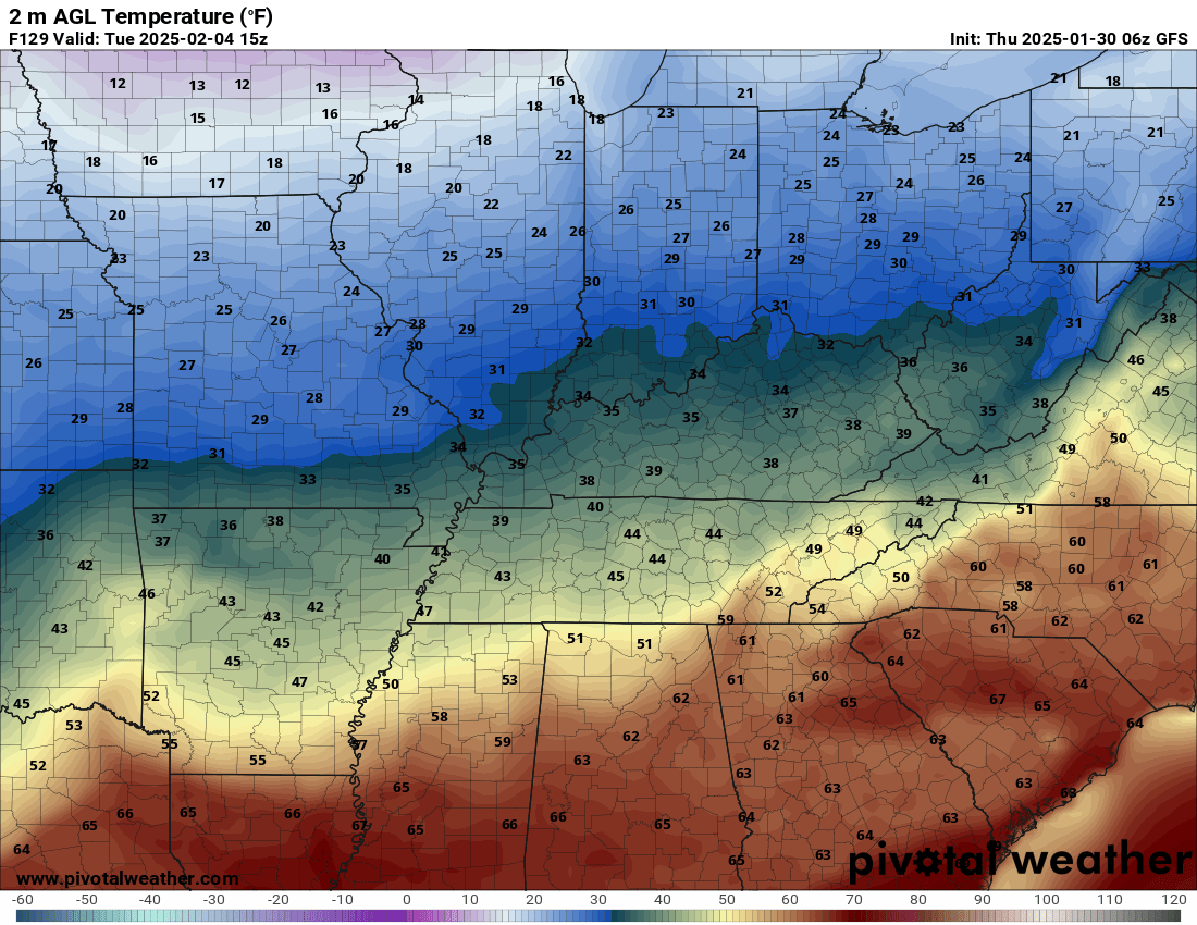
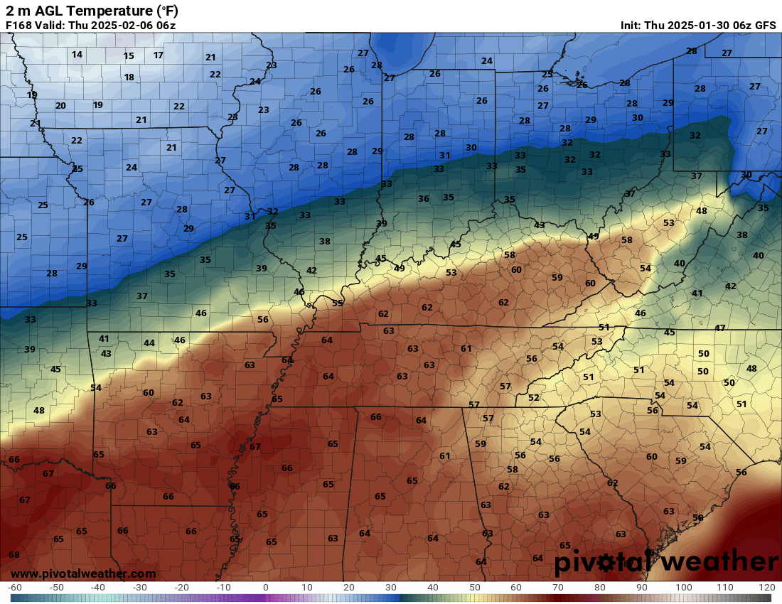
Check out temperatures next week.
This is the GFS model. That boundary between the cold and warm will be the battle zone. That is where precipitation will likely develop.
An ice storm in the cold zone. Locally heavy rain in the warm zone.
Tuesday morning temperatures. Cold air flirting with our region. Warm air to the south.
Wednesday night temperatures. Cold north. Warm south. We are in the battle zone.
.
.![]()
.
Click here if you would like to return to the top of the page.
This outlook covers southeast Missouri, southern Illinois, western Kentucky, and far northwest Tennessee.

.
Today’s Storm Prediction Center’s (SPC) Severe Weather Outlook
Light green is where thunderstorms may occur but should be below severe levels.
Dark green is a level one risk. Yellow is a level two risk. Orange is a level three (enhanced) risk. Red is a level four (moderate) risk. Pink is a level five (high) risk.
One is the lowest risk. Five is the highest risk.
A severe storm is one that produces 58 mph wind or higher, quarter or larger size hail, and/or a tornado.
Explanation of tables. Click here.
Day One Severe Weather Outlook

Day One Severe Weather Outlook. Zoomed in on our region.

.
Day One Tornado Probability Outlook

Day One Regional Tornado Outlook. Zoomed in on our region.

.
Day One Large Hail Probability Outlook

Day One Regional Hail Outlook. Zoomed in on our region.

.
Day One High wind Probability Outlook

Day One Regional Wind Outlook. Zoomed in on our region.

.
Tomorrow’s severe weather outlook. Day two outlook.

Day Two Outlook. Zoomed in on our region.

.
Day Three Severe Weather Outlook

.
![]()
..![]()

.
Click here if you would like to return to the top of the page.
.Average high temperatures for this time of the year are around 44 degrees.
Average low temperatures for this time of the year are around 27 degrees.
Average precipitation during this time period ranges from 0.90″ to 1.20″
Six to Ten Day Outlook.
Blue is below average. Red is above average. The no color zone represents equal chances.
Average highs for this time of the year are in the lower 60s. Average lows for this time of the year are in the lower 40s.

Green is above average precipitation. Yellow and brown favors below average precipitation. Average precipitation for this time of the year is around one inch per week.

.

Average low temperatures for this time of the year are around 27 degrees.
Average precipitation during this time period ranges from 0.90″ to 1.20″
.
Eight to Fourteen Day Outlook.
Blue is below average. Red is above average. The no color zone represents equal chances.

Green is above average precipitation. Yellow and brown favors below average precipitation. Average precipitation for this time of the year is around one inch per week.

.
![]()
Make sure you have three to five ways of receiving your severe weather information.
Weather Talk is one of those ways! Now, I have another product for you and your family.

.
.
https://weathercallservices.com/beau-dodson-weather


Want to add more products to your Beau Dodson Weather App?
Receive daily videos, weather blog updates on normal weather days and severe weather and winter storm days, your county by county weather forecast, and more!
Here is how to do add those additional products to your app notification settings!
Here is a video on how to update your Beau Dodson Weather payment.
The app is for subscribers. Subscribe at www.weathertalk.com/welcome then go to your app store and search for WeatherTalk
Subscribers, PLEASE USE THE APP. ATT and Verizon are not reliable during severe weather. They are delaying text messages.
The app is under WeatherTalk in the app store.

Apple users click here

Android users click here
.

Radars and Lightning Data
Interactive-city-view radars. Clickable watches and warnings.
https://wtalk.co/B3XHASFZ
Old legacy radar site (some of you like it better)
https://weatherobservatory.com/weather-radar.htm
If the radar is not updating then try another one. If a radar does not appear to be refreshing then hit Ctrl F5. You may also try restarting your browser.
Backup radar site in case the above one is not working.
https://weathertalk.com/morani
Regional Radar
https://imagery.weathertalk.com/prx/RadarLoop.mp4
** NEW ** Zoom radar with chaser tracking abilities!
ZoomRadar
Lightning Data (zoom in and out of your local area)
https://wtalk.co/WJ3SN5UZ
Not working? Email me at beaudodson@usawx.com
National map of weather watches and warnings. Click here.
Storm Prediction Center. Click here.
Weather Prediction Center. Click here.
.

Live lightning data: Click here.
Real time lightning data (another one) https://map.blitzortung.org/#5.02/37.95/-86.99
Our new Zoom radar with storm chases
.
.

Interactive GOES R satellite. Track clouds. Click here.
GOES 16 slider tool. Click here.
College of DuPage satellites. Click here
.

Here are the latest local river stage forecast numbers Click Here.
Here are the latest lake stage forecast numbers for Kentucky Lake and Lake Barkley Click Here.
.
.
Find Beau on Facebook! Click the banner.


 .
.