.
Click one of the links below to take you directly to that section
![]()
![]()
![]()
![]()
![]()
![]()
![]()
Do you have any suggestions or comments? Email me at beaudodson@usawx.com
.
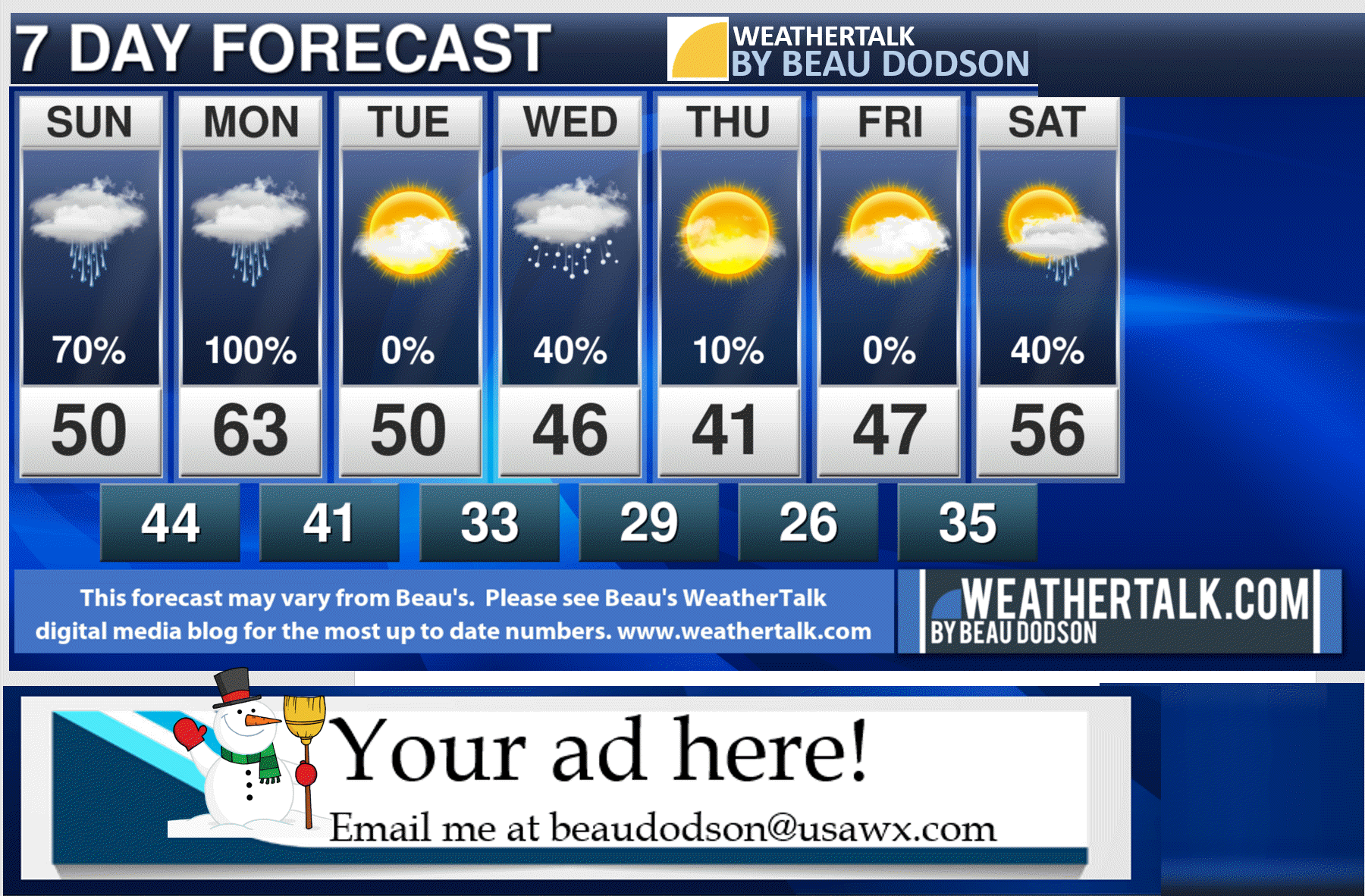
7-day forecast for southeast Missouri, southern Illinois, western Kentucky, and western Tennessee.
This is a BLEND for the region. See the detailed region by region forecast further down in this post.
WIDE range of temperatures tonight into Monday ahead of our next rain event. See daily details further down (for each region).
.


.
.

.
Sunday to Sunday
1. Are accumulating snow or ice in the forecast? Unlikely. I will keep an eye on Wednesday. Perhaps a light wintry mix.
2. Is lightning in the forecast? Yes. Lightning is possible late tonight and Monday.
3. Are severe thunderstorms in the forecast? Monitor. I will keep an eye on Monday. Perhaps a few strong thunderstorms over Kentucky and Tennessee.
* The NWS officially defines a severe thunderstorm as a storm with 58 mph wind or greater, 1″ hail or larger, and/or tornadoes
4. Is flash flooding in the forecast? Monitor. Some nuisance flooding is possible. Easily flooded roadways. Ditches. Fields. Streams may see rapid rises late tonight and Monday.
6. Will the wind chill dip below 10 degrees above zero? No.
..

January 24, 2020
How confident am I that this days forecast will verify? High Confidence
Sunday Forecast: Mostly cloudy. AM rain showers. Any freezing rain will change to rain (northern counties where it is colder).
What is the chance of precipitation? SE MO ~ 60% (early) IL ~ 70% (mainly early) KY ~ 60% TN ~ 60%
Temperature range: MO Bootheel 44° to 48° SE MO 44° to 48° South IL 44° to 48° Northwest KY (near Indiana border) 44° to 46° West KY 44° to 48° NW TN 44° to 48°
Wind direction and speed: South southeast at 6 to 12 mph
Wind chill or heat index (feels like) temperature forecast: 42° to 46°
Coverage of precipitation: Scattered (mainly early )
What impacts are anticipated from the weather? Wet roadways
Should I cancel my outdoor plans? No
UV Index: 2. Low
Sunrise: 7:04 AM
Sunset: 5:11 PM
.
Sunday night Forecast: Cloudy. A chance of showers before midnight. Then, showers and thunderstorms. Locally heavy rain.
What is the chance of precipitation? SE MO ~ 0% IL ~ 0% KY ~ 0% TN ~ 0%
Temperature range: MO Bootheel 40° to 44° SE MO 34° to 38° South IL 35° to 40° Northwest KY (near Indiana border) 35° to 40° West KY 40° to 44° NW TN 40° to 45°
Wind direction and speed: East at 6 to 12 mph
Wind chill or heat index (feels like) temperature forecast: 32° to 42°
Coverage of precipitation: Increasing coverage overnight.
What impacts are anticipated from the weather? Wet roadways. Lightning. Monitor the risk of storms early in the morning.
Should I cancel my outdoor plans? No, but monitor radars.
Moonrise: 1:32 PM
Moonset: 3:36 AM
The phase of the moon: Waxing Crescent
.
January 25, 2020
How confident am I that this days forecast will verify? High Confidence
Monday Forecast: Mostly cloudy. Breezy, at times. Rain and thunderstorms. Locally heavy rain. A chance of hail. A few storms over the Missouri Bootheel into Kentucky and Tennessee could be intense.
What is the chance of precipitation? SE MO ~ 100% IL ~ 100% KY ~ 100% TN ~ 100%
Temperature range: MO Bootheel 56° to 62° SE MO 50° north to 55° South IL 48° north to 54° south Northwest KY (near Indiana border) 52° to 55° West KY 50° to 55° NW TN 58° to 64°
Wind direction and speed: East becoming southeast and eventually southwest at 10 to 20 mph. Gusty.
Wind chill or heat index (feels like) temperature forecast: 45° to 60°
Coverage of precipitation: Widespread
What impacts are anticipated from the weather? Wet roadways. Gusty wind. Lightning. Monitor the risk of severe weather. A chance of hail.
Should I cancel my outdoor plans? Have a plan B.
UV Index: 1. Low
Sunrise: 7:03 AM
Sunset: 5:13 PM
.
Monday night Forecast: Mostly cloudy. Evening rain ending.
What is the chance of precipitation? SE MO ~ 0% IL ~ 0% KY ~ 20% TN ~ 20%
Temperature range: MO Bootheel 36° to 40° SE MO 34° to 38° South IL 34° to 38° Northwest KY (near Indiana border) 34° to 38° West KY 36° to 40° NW TN 38° to 42°
Wind direction and speed: West southwest at 8 to 16 mph
Wind chill or heat index (feels like) temperature forecast: 32° to 40°
Coverage of precipitation: Ending
What impacts are anticipated from the weather? Wet roadways, early in the night.
Should I cancel my outdoor plans? No
Moonrise: 2:16 PM
Moonset: 4:35 AM
The phase of the moon: Waxing Crescent
.
January 26, 2020
How confident am I that this days forecast will verify? High Confidence
Tuesday Forecast: Partly sunny.
What is the chance of precipitation? SE MO ~ 0% IL ~ 0% KY ~ 0% TN ~ 0%
Temperature range: MO Bootheel 48° to 50° SE MO 45° to 50° South IL 45° to 50° Northwest KY (near Indiana border) 45° to 50° West KY 46° to 50° NW TN 48° to 52°
Wind direction and speed: West northwest 6 to 12 mph
Wind chill or heat index (feels like) temperature forecast: 45° to 50°
Coverage of precipitation: None
What impacts are anticipated from the weather? None
Should I cancel my outdoor plans? No
UV Index: 2. Low.
Sunrise: 7:03 AM
Sunset: 5:14 PM
.
Tuesday night Forecast: Increasing clouds from the southwest. A slight chance of freezing rain and snow over mainly southeast Missouri after midnight.
What is the chance of precipitation? SE MO ~ 0% IL ~ 0% KY ~ 0% TN ~ 0%
Temperature range: MO Bootheel 28° to 32° SE MO 24° to 28° South IL 24° to 28° Northwest KY (near Indiana border) 24° to 28° West KY 25° to 30° NW TN 26° to 32°
Wind direction and speed: North northeast at 5 to 10 mph
Wind chill or heat index (feels like) temperature forecast: 20° to 25°
Coverage of precipitation: Isolated after midnight
What impacts are anticipated from the weather? Monitor updates in case some freezing precipitation moves in after midnight.
Should I cancel my outdoor plans? No, but monitor updates
Moonrise: 3:09 PM
Moonset: 5:32 AM
The phase of the moon: Waxing Crescent
.
January 27, 2020
How confident am I that this days forecast will verify? Medium Confidence
Wednesday Forecast: Mostly cloudy. Rain and snow showers likely.
What is the chance of precipitation? SE MO ~ 50% IL ~ 60% KY ~ 60% TN ~ 60%
Temperature range: MO Bootheel 38° to 42° SE MO 34° to 38° South IL 34° to 38° Northwest KY (near Indiana border) 34° to 38° West KY 34° to 38° NW TN 34° to 38°
Wind direction and speed: North 6 to 12 mph with gusts to 18 mph
Wind chill or heat index (feels like) temperature forecast: 30° to 40°
Coverage of precipitation: Numerous
What impacts are anticipated from the weather? Wet roadways. Snow is not out of the question. Monitor updates.
Should I cancel my outdoor plans? No, but monitor updates and radars.
UV Index: 1. Low
Sunrise: 7:02 AM
Sunset: 5:15 PM
.
Wednesday night Forecast: Mostly cloudy. Any remaining snow or rain will come to an end. Cold.
What is the chance of precipitation? SE MO ~ 10% IL ~ 30% KY ~ 30% TN ~ 30%
Temperature range: MO Bootheel 24° to 28° SE MO 22° to 25° South IL 22° to 25° Northwest KY (near Indiana border) 24° to 26° West KY 24° to 28° NW TN 24° to 28°
Wind direction and speed: North 8 to 16 mph.
Wind chill or heat index (feels like) temperature forecast: 15° to 20°
Coverage of precipitation: Scattered early
What impacts are anticipated from the weather? Wet roadways. Monitor updates in case we have colder temperatures.
Should I cancel my outdoor plans? No, but check radars.
Moonrise: 4:09 PM
Moonset: 6:24 AM
The phase of the moon: Waxing Crescent
.
January 28, 2020
How confident am I that this days forecast will verify? High Confidence
Thursday Forecast: Mostly sunny.
What is the chance of precipitation? SE MO ~ 0% IL ~ 0% KY ~ 0% TN ~ 0%
Temperature range: MO Bootheel 36° to 40° SE MO 34° to 36° South IL 34° to 38° Northwest KY (near Indiana border) 34° to 38° West KY 34° to 38° NW TN 36° to 40°
Wind direction and speed: North 7 to 14 mph. Gusty.
Wind chill or heat index (feels like) temperature forecast: 34° to 38°
Coverage of precipitation: None
What impacts are anticipated from the weather? None
Should I cancel my outdoor plans? No
UV Index: 2. Low
Sunrise: 7:01 AM
Sunset: 5:16 PM
.
Thursday night Forecast: Mostly clear.
What is the chance of precipitation? SE MO ~ 0% IL ~ 0% KY ~ 0% TN ~ 0%
Temperature range: MO Bootheel 24° to 26° SE MO 23° to 26° South IL 23° to 26° Northwest KY (near Indiana border) 23° to 26° West KY 24° to 28° NW TN 24° to 28°
Wind direction and speed: Variable direction at 5 mph
Wind chill or heat index (feels like) temperature forecast: 22° to 26°
Coverage of precipitation: None
What impacts are anticipated from the weather? None
Should I cancel my outdoor plans? No
Moonrise: 5:13 PM
Moonset: 7:12 AM
The phase of the moon: Full
.
January 29, 2020
How confident am I that this days forecast will verify? High Confidence
Friday Forecast: Partly cloudy.
What is the chance of precipitation? SE MO ~ 0% IL ~ 0% KY ~ 0% TN ~ 0%
Temperature range: MO Bootheel 45° to 50° SE MO 43° to 46° South IL 43° to 46° Northwest KY (near Indiana border) 43° to 46° West KY 44° to 46° NW TN 45° to 50°
Wind direction and speed: South 5 to 10 mph
Wind chill or heat index (feels like) temperature forecast: 42° to 54°
Coverage of precipitation: None
What impacts are anticipated from the weather? None
Should I cancel my outdoor plans? No
UV Index: 2. Low
Sunrise: 7:01 AM
Sunset: 5:17 PM
.
Friday night Forecast: Increasing clouds.
What is the chance of precipitation? SE MO ~ 0% IL ~ 0% KY ~ 0% TN ~ 0%
Temperature range: MO Bootheel 33° to 36° SE MO 32° to 35° South IL 32° to 35° Northwest KY (near Indiana border) 32° to 35° West KY 33° to 36° NW TN 33° to 36°
Wind direction and speed: South 7 to 14 mph. Gusty.
Wind chill or heat index (feels like) temperature forecast: 26° to 34°
Coverage of precipitation: Most likely none.
What impacts are anticipated from the weather? None
Should I cancel my outdoor plans? No
Moonrise: 6:21 PM
Moonset: 7:54 PM
The phase of the moon: Waning Gibbous
.
January 30, 2020
How confident am I that this days forecast will verify? Low Confidence
Saturday Forecast: Increasing clouds. A chance of scattered showers. A thunderstorm is possible. I will need to monitor the timing of this system. Saturday or Sunday is in play.
What is the chance of precipitation? SE MO ~ 50% IL ~ 50% KY ~ 50% TN ~ 50%
Temperature range: MO Bootheel 52° to 55° SE MO 50° to 54° South IL 50° to 54° Northwest KY (near Indiana border) 50° to 54° West KY 50° to 55° NW TN 53° to 56°
Wind direction and speed: South 10 to 20 mph. Gusty.
Wind chill or heat index (feels like) temperature forecast: 45° to 55°
Coverage of precipitation: Scattered
What impacts are anticipated from the weather? Wet roadways. Lightning.
Should I cancel my outdoor plans? Monitor updates and radars.
UV Index: 2. Low
Sunrise: 7:00 AM
Sunset: 5:18 PM
.
Saturday night Forecast: Mostly cloudy. A chance of showers. Thunderstorms are possible.
What is the chance of precipitation? SE MO ~ 60% IL ~ 60% KY ~ 60% TN ~ 60%
Temperature range: MO Bootheel 40° to 45° SE MO 35° to 40° South IL 35° to 40° Northwest KY (near Indiana border) 35° to 40° West KY 40° to 45° NW TN 40° to 45°
Wind direction and speed: Southwest 8 to 16 mph
Wind chill or heat index (feels like) temperature forecast: 30° to 40°
Coverage of precipitation: Widespread
What impacts are anticipated from the weather? Wet roadways. Lightning.
Should I cancel my outdoor plans? Have a plan B.
Moonrise: 7:30 PM
Moonset: 8:30 AM
The phase of the moon: Waning Crescent
.
January 31, 2020
How confident am I that this days forecast will verify? Low Confidence
Sunday Forecast: Mostly cloudy. A chance of showers.
What is the chance of precipitation? SE MO ~ 30% IL ~ 30% KY ~ 30% TN ~ 30%
Temperature range: MO Bootheel 45° to 50° SE MO 45° to 50° South IL 45° to 50° Northwest KY (near Indiana border) 45° to 50° West KY 45° to 50° NW TN 45° to 50°
Wind direction and speed:
Wind chill or heat index (feels like) temperature forecast: 45° to 50°
Coverage of precipitation: Scattered
What impacts are anticipated from the weather? Wet roadways.
Should I cancel my outdoor plans? Monitor updates.
UV Index: 2. Low
Sunrise: 6:59 AM
Sunset: 5:19 PM
.
Sunday night Forecast: Intervals of clouds.
What is the chance of precipitation? SE MO ~ 0% IL ~ 0% KY ~ 0% TN ~ 0%
Temperature range: MO Bootheel 30° to 35° SE MO 30° to 34° South IL 30° to 34° Northwest KY (near Indiana border) 30° to 34° West KY 30° to 34° NW TN 30° to 34°
Wind direction and speed:
Wind chill or heat index (feels like) temperature forecast: 30° to 32°
Coverage of precipitation: None
What impacts are anticipated from the weather? None
Should I cancel my outdoor plans? No
Moonrise: 8:38 PM
Moonset: 9:04 AM
The phase of the moon: Waning Crescent
.

.
The AM AG weather report will return in late winter and early spring (when growing season returns).
Please refer to the long range video until that time.
.
![]()
![]()
Graphic-cast
Click here if you would like to return to the top of the page.
Illinois
During active weather check my handwritten forecast towards the top of the page.

.
Kentucky
During active weather check my handwritten forecast towards the top of the page.


.

.

.
Tennessee
During active weather check my handwritten forecast towards the top of the page.

.
.
Today through January 27th. A few strong storms are possible Monday. Gusty wind is the primary concern. A low-end tornado risk.
.
Today’s outlook (below).
Light green is where thunderstorms may occur but should be below severe levels.
Dark green is a level one risk. Yellow is a level two risk. Orange is a level three (enhanced) risk. Red is a level four (moderate) risk. Pink is a level five (high) risk.
One is the lowest risk. Five is the highest risk.
A severe storm is one that produces 58 mph wind or higher, quarter size hail, and/or a tornado.
The tan states are simply a region that SPC outlined on this particular map. Just ignore that.

The black outline is our local area.

.
Tomorrow’s severe weather outlook.

.

.
The images below are from the WPC. Their totals are a bit lower than our current forecast. I wanted to show you the comparison.
24-hour precipitation outlook.
.
 .
.
48-hour precipitation outlook.
.
.
72-hour precipitation outlook.
.
![]()

![]()
..
Weather advice:
A few of the thunderstorms Monday morning and afternoon could be strong. Locally heavy rain, as well.
Beau’s Weather Talk App by the Fire Horn. Download it. Install it. It is for subscribers. Not a subscriber? Go to www.weathertalk.com/welcome
.
Weather Discussion

-
- Wet weather
- Monitoring the chance of thunderstorms and perhaps some wintry mix
An active weather pattern over the coming days.
First off, we had some freezing rain, sleet, and snow this morning. Mainly over southern Illinois and northwest Kentucky.
Temperatures are rising. Thus, any frozen precipitation will come to an end.
A strong winter storm will develop tonight and Monday across the Missouri and Ohio Valley.
This system will bring widespread heavy snow to portions of Iowa, northern Missouri, northern Illinois, and into the Great Lakes.
We will be on the warm side. As a matter of fact, temperatures may rise into the 60s Monday. This is especially true across far southeast Missouri, extreme southern Illinois, Kentucky, and Tennessee.
We call that the warm sector of the storm. That happens when the area of low pressure pushes to our north. Not a winter storm track for our region.
If you want snow locally, then you usually want to see the area of low pressure pass through Arkansas and Louisiana and then eastward into Tennessee and the Gulf Coast area. That puts us on the cold side of the storm.
This time around, the snow will miss our region.
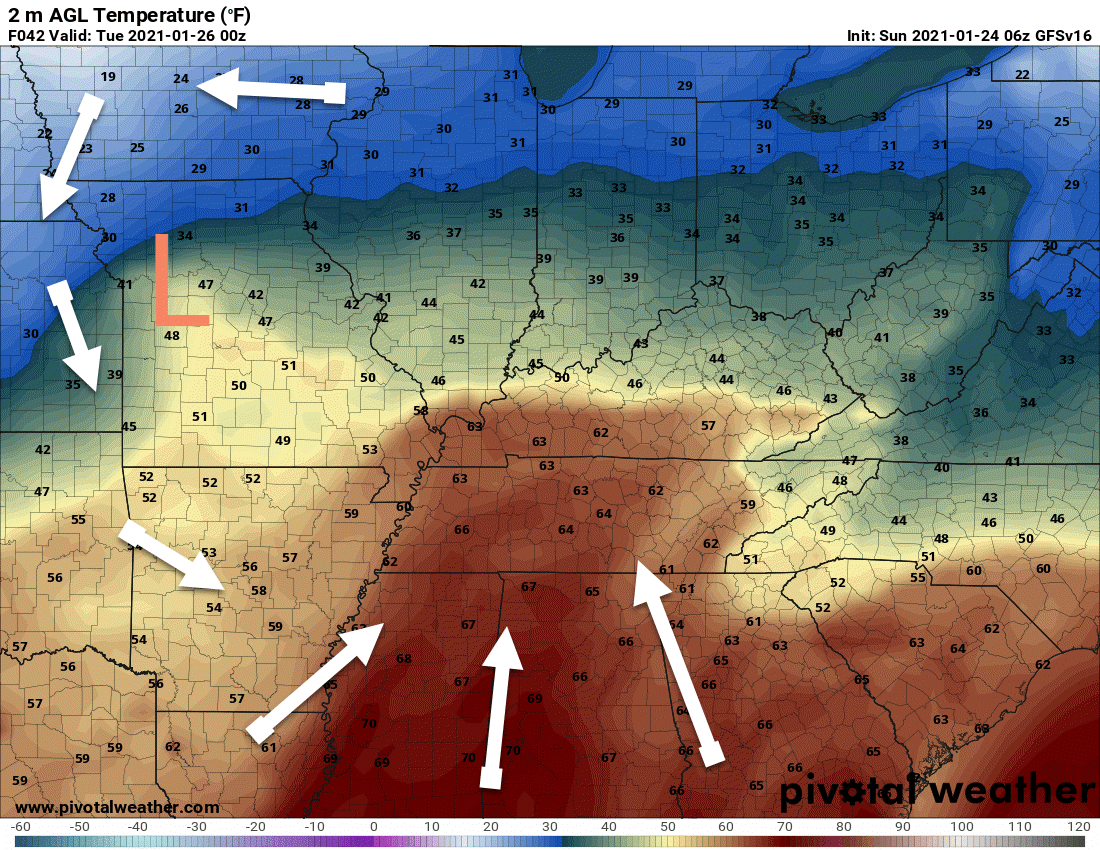
You can see the track of the low on these maps. See the L?
The white arrows are wind barbs. Winds ahead of the system will be out of the south. That is why warmer air will push into the region tonight and Monday.
That also brings a lot more moisture to our local area. Thus, locally heavy rain will be possible.
Monday afternoon map
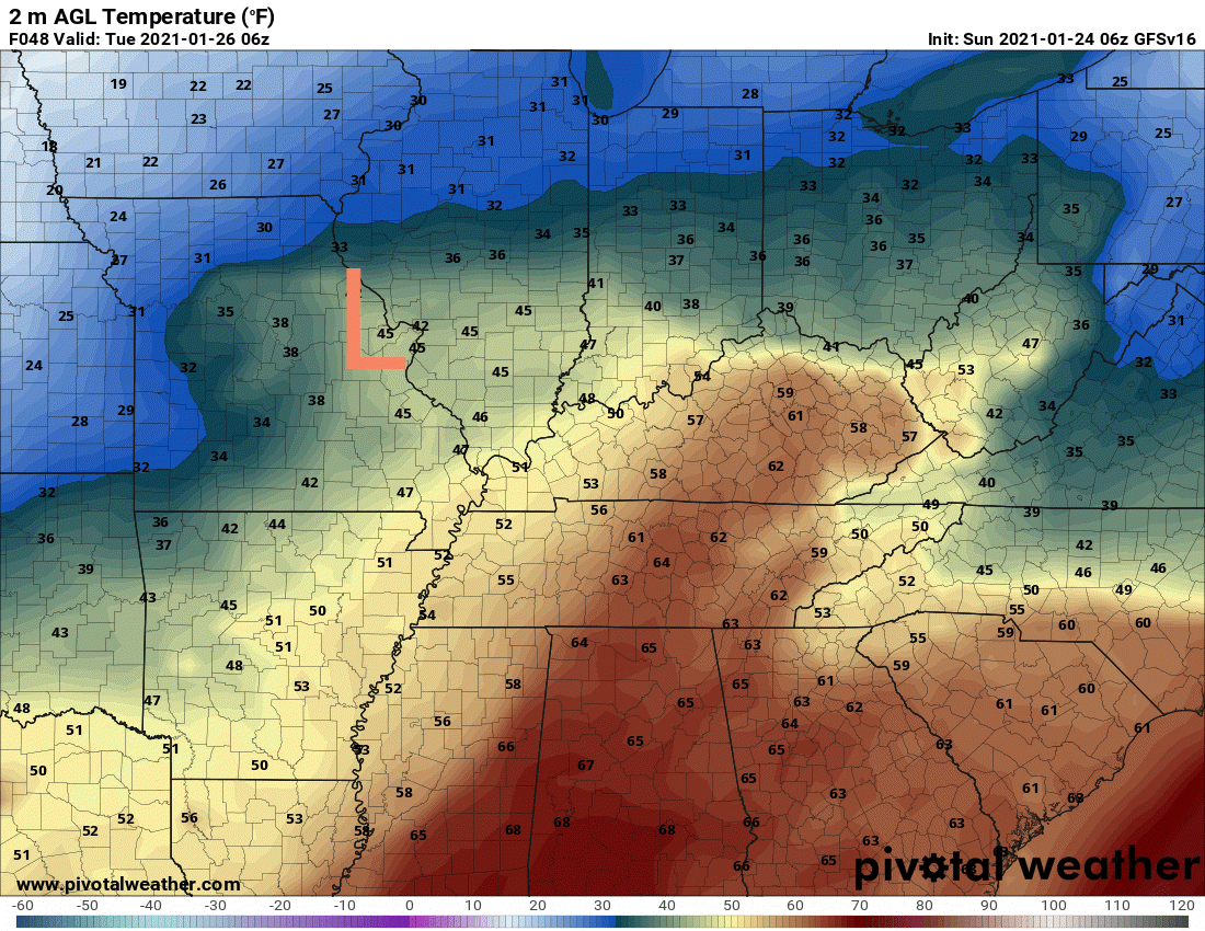
Monday night map. The low is pushing east/northeast. The colder air will arrive behind the system.
.
There will be no shortage of moisture with this system. Some of the rain will be heavy.
This is likely going to be a widespread one to two inch rain events. Pockets of two to three inches are likely along the warm front. That is where some of the heavier rain and storms will train (repeatedly move over the same area).
Some low-land flooding will be possible. Fields, commonly flooded roadways, and so on.
Check out the PWAT values. PWAT is a measure of moisture in the entire atmosphere from top to bottom.
These numbers are 200% to 300% above normal for this time of the year. In other words, the system is loaded with moisture.
See the surge of moisture ahead of the area of low pressure? Click on the images and animations to enlarge.
.
We will have some instability ahead of the system, as well.
A few of the thunderstorms could be intense over the Missouri Bootheel into western Kentucky and Tennessee. I will keep an eye on extreme southern Illinois, as well.
The main concern will be after 5 AM Monday morning into the afternoon.
A few storms could produce high winds. A short-lived tornado will also be possible. Overall, confidence in severe weather occurring is rather low.
Let’s look at the CAPE maps. CAPE is basically energy for thunderstorms to tap into.
There are several types of CAPE.
Usually, for large hail and tornadoes we look at surface based CAPE. During the winter months, however, we like to look at the entire atmosphere. We can have mid-level CAPE, as well.
Here is an animation of all the forms of CAPE. Notice that we have some CAPE during the early morning hours and then into the afternoon.
The best chance of severe weather will likely be between 4 AM and 12 PM. After that, the system may shut down and storm formation becomes unlikely.
.
The NAM model shows some surface based CAPE Monday afternoon and evening. By then, the better moisture will have pushed off to the east. That means, additional thunderstorms forming is questionable, at best.
If storms were to form Monday afternoon then they could be intense (in the shaded areas below). It does seem unlikely that new storms would form in the surface based CAPE zone (locally, at least). I will keep an eye on this.
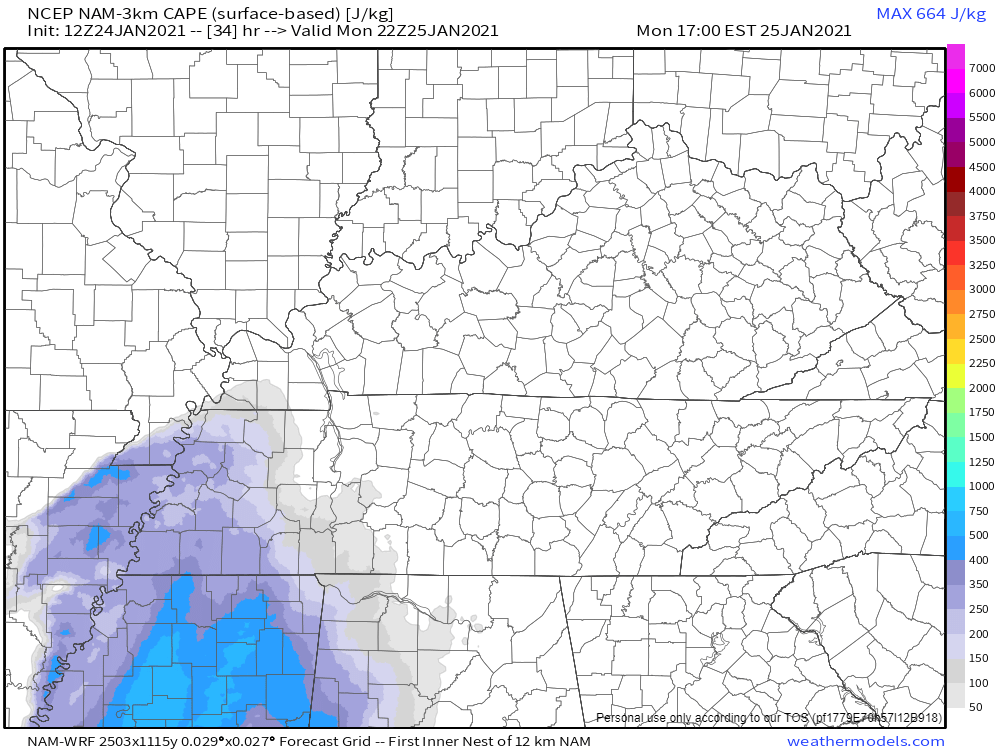
Late Monday afternoon
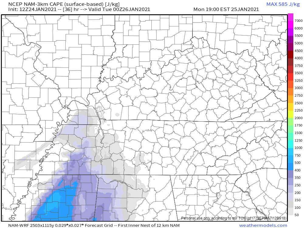
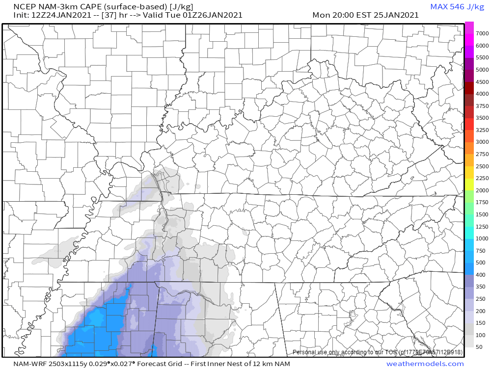
And then the surface based CAPE wanes as we move into Monday evening.
.
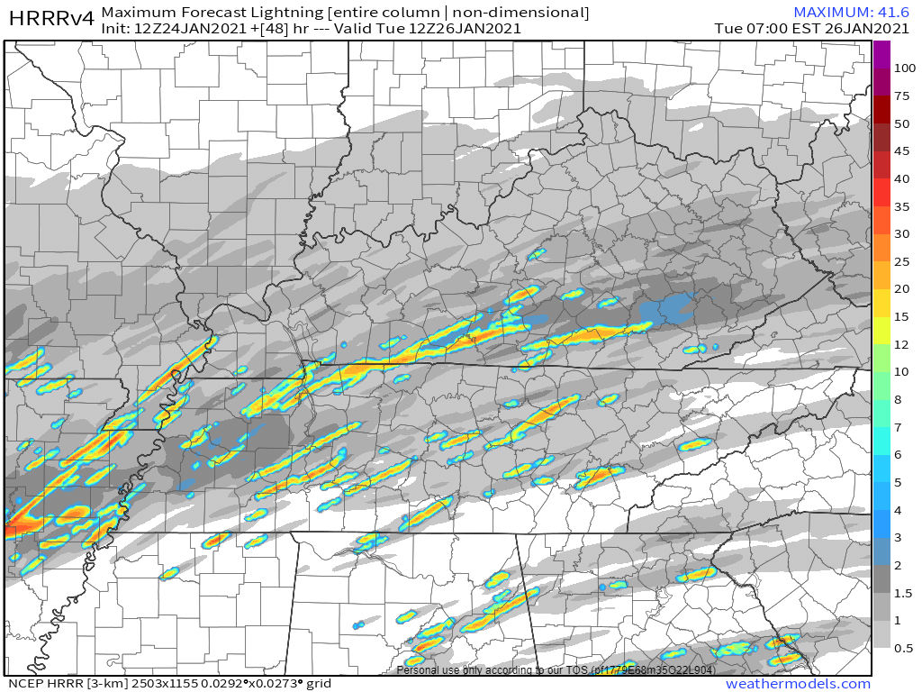
The lightning forecast map shows that there will be at least a chance of lightning throughout the area. The brighter colors represent a bit more lightning. This would be late tonight into Monday.
.
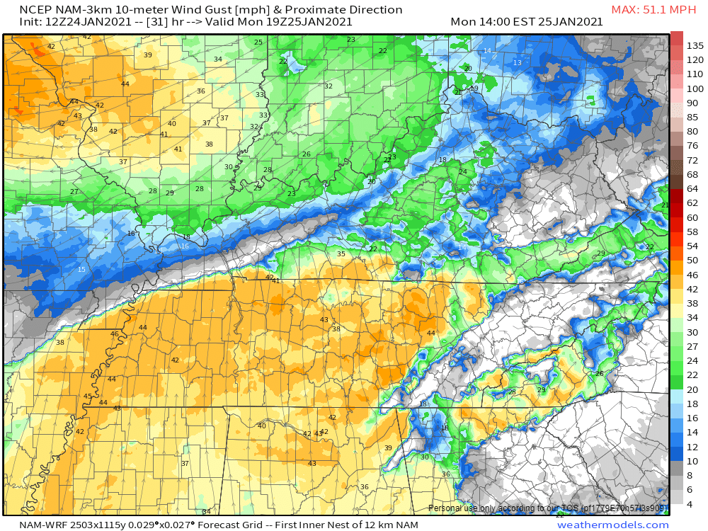
There will be gusty winds with this system. Wind speed will vary considerably across the region. This will depend on where the warm front is situated.
Notice the difference on the map below. This is late Monday morning into the afternoon.
.
We dry out Monday night into Tuesday night. That would be behind the system.
I am monitoring a fast moving system that will push into the region Wednesday and Wednesday evening.
This will spread rain and snow back into the area.
Model guidance is not in agreement on the strength of that system. The GFS shows accumulating snow. Other models do not.
For now, I have a rain/snow mix in the forecast. Monitor updates.
Dry Thursday into Friday night.
Another rain event is possible over the weekend. Perhaps some thunderstorms.
.


Click here if you would like to return to the top of the page.
Again, as a reminder, these are models. They are never 100% accurate. Take the general idea from them.
What should I take from these?
- The general idea and not specifics. Models usually do well with the generalities.
- The time-stamp is located in the upper left corner.
- The EC European weather model is in Zulu time.
.
What am I looking at?
You are looking at different models. Meteorologists use many different models to forecast the weather. All models are wrong. Some are more wrong than others. Meteorologists have to make a forecast based on the guidance/models.
I show you these so you can see what the different models are showing as far as precipitation. If most of the models agree, then the confidence in the final weather forecast increases.
You can see my final forecast at the top of the page.
.
This animation is the Storm Prediction Center WRF model.
This animation shows you what radar might look like as the next system pulls through the region. It is a future-cast radar.
Time-stamp upper left. Click the animation to enlarge it.
.
This animation is the Hrrr short-range model.
.
This animation is the 3K NAM American Model.
This animation shows you what radar might look like as the next system pulls through the region. It is a future-cast radar.
Time-stamp upper left. Click the animation to enlarge it.
.
This next animation is the lower-resolution NAM American Model.
This animation shows you what radar might look like as the system pulls through the region. It is a future-cast radar.
Time-stamp upper left. Click the animation to enlarge it.
.
This next animation is the GFS American Model.
This animation shows you what radar might look like as the system pulls through the region. It is a future-cast radar.
Time-stamp upper left. Click the animation to enlarge it.
.
This next animation is the EC European Weather model.
This animation shows you what radar might look like as the system pulls through the region. It is a future-cast radar.
Time-stamp upper left. Click the animation to enlarge it.
.
![]()
.


.
Click here if you would like to return to the top of the page.
.
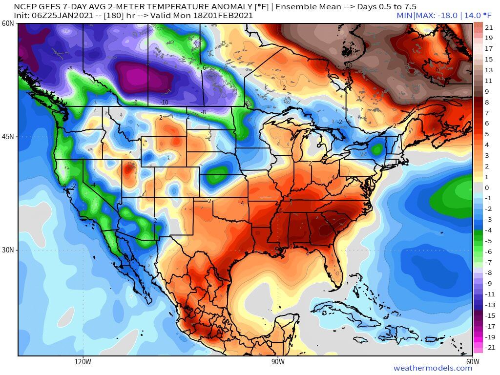
Average high temperatures for this time of the year are around 44 degrees.
Average low temperatures for this time of the year are around 27 degrees.
Average precipitation during this time period ranges from 0.70″ to 1.00″
Yellow and orange colors are above average temperatures. Red is much above average. Light blue and blue are below-average temperatures. Green to purple colors represents much below-average temperatures.
This outlook covers January 25th through January 31st
Click on the image to expand it.
.
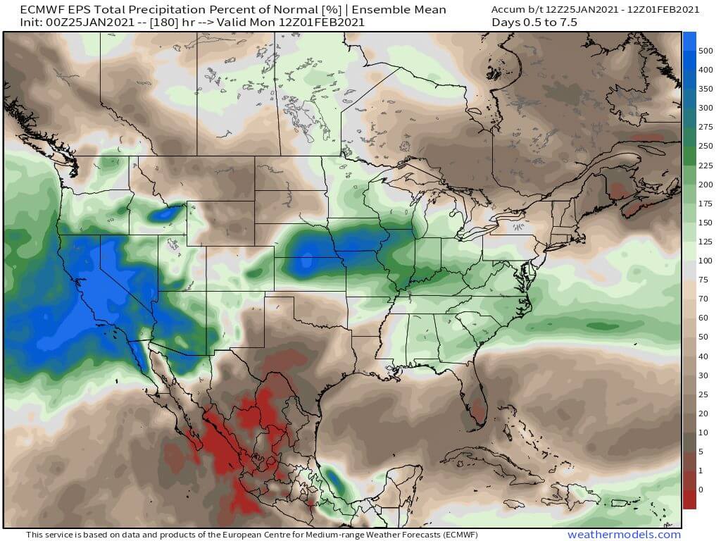
The precipitation forecast is PERCENT OF AVERAGE. Brown is below average. Green is above average. Blue is much above average.
.

Average low temperatures for this time of the year are around 30 degrees
Average precipitation during this time period ranges from 0.70″ to 1.00″
.
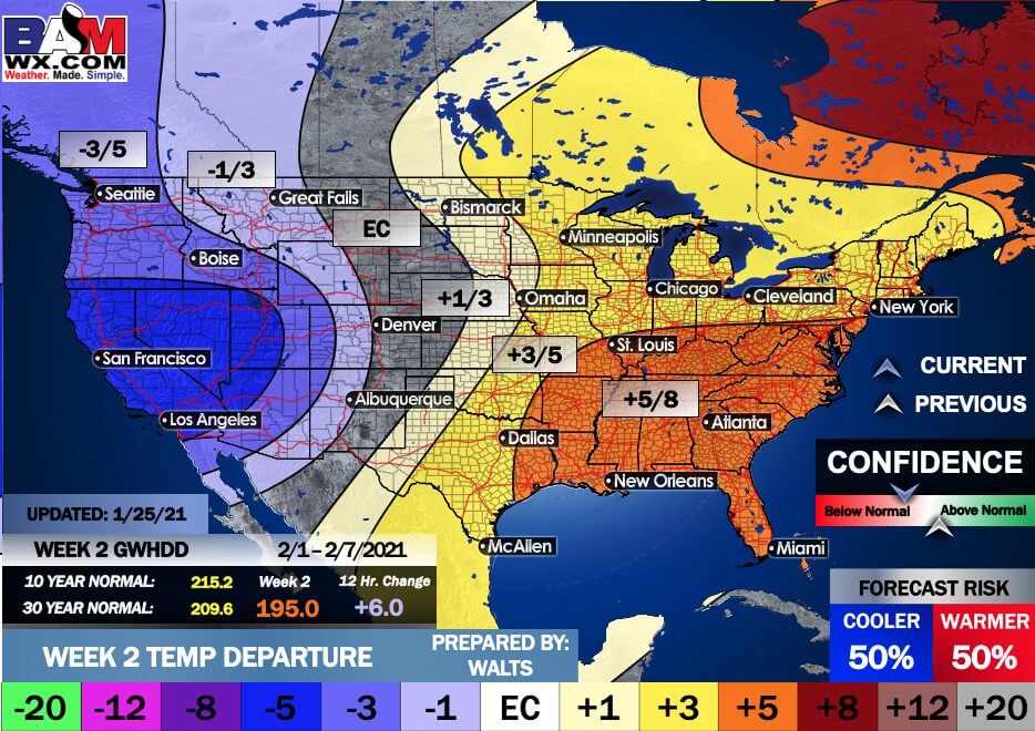
This outlook covers February 1st through February 7th
Click on the image to expand it.
.
The precipitation forecast is PERCENT OF AVERAGE. Brown is below average. Green is above average. Blue is much above average.
.
.

EC = Equal chances of above or below average
BN= Below average
M/BN = Much below average
AN = Above average
M/AN = Much above average
E/AN = Extremely above average
Average low temperatures for this time of the year are around 24 degrees
Average precipitation during this time period ranges from 1.40″ to 2.00″
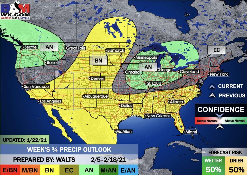
This outlook covers February 5th through February 18th
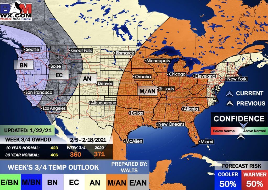
.
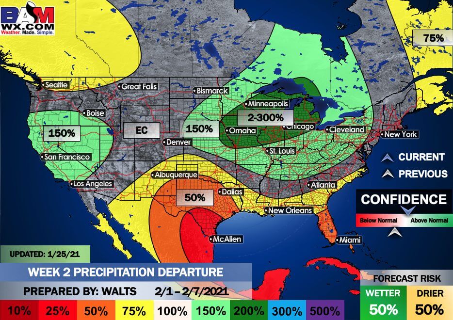
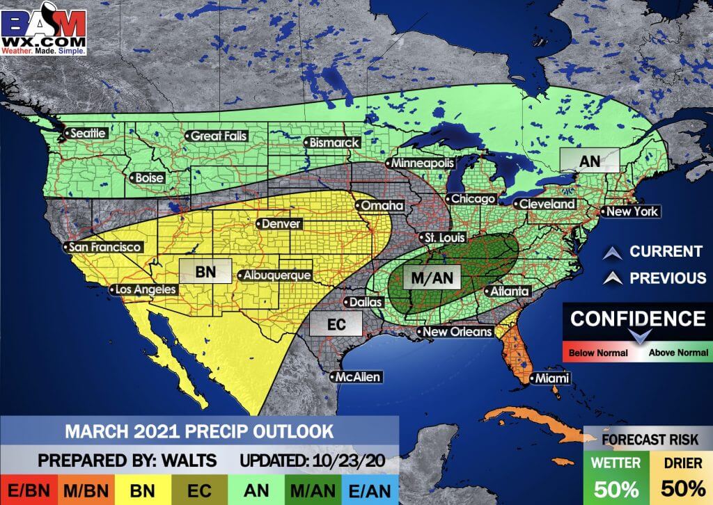
Precipitation outlook
LONG RANGE DISCUSSION
Key Points: This was written by the BAMwx team. I don’t edit it.
THIS WILL RETURN IN THE SPRING. DURING THE GROWING SEASON.
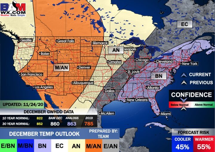
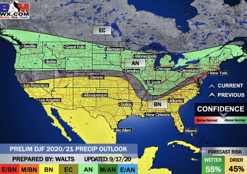
Winter Outlook
Click to enlarge it. Then, you can read it better.
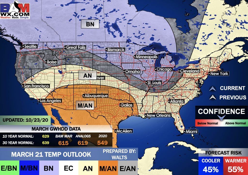
December through February Temperature Outlook (preliminary)
December through February Precipitation Outlook (preliminary)
..
E/BN extremely below normal.
M/BN is much below normal
EC equal chances
AN above normal
M/AN much above normal
E/AN extremely above normal.
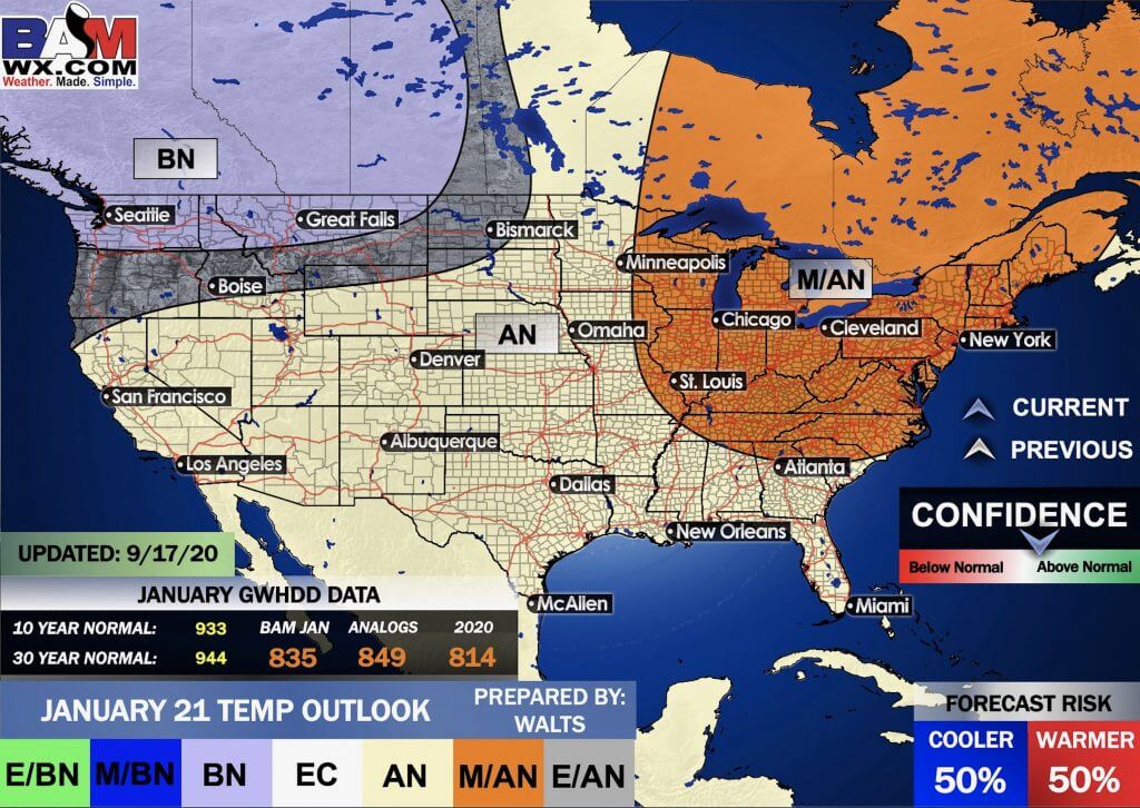
January Temperature Outlook (preliminary)
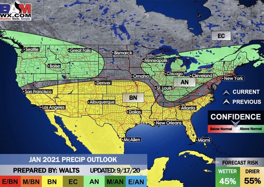
January Precipitation Outlook (preliminary)
.
E/BN extremely below normal.
M/BN is much below normal
EC equal chances
AN above normal
M/AN much above normal
E/AN extremely above normal.
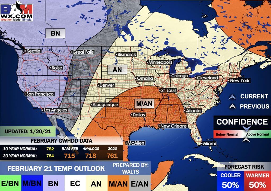
February Temperature Outlook (preliminary)
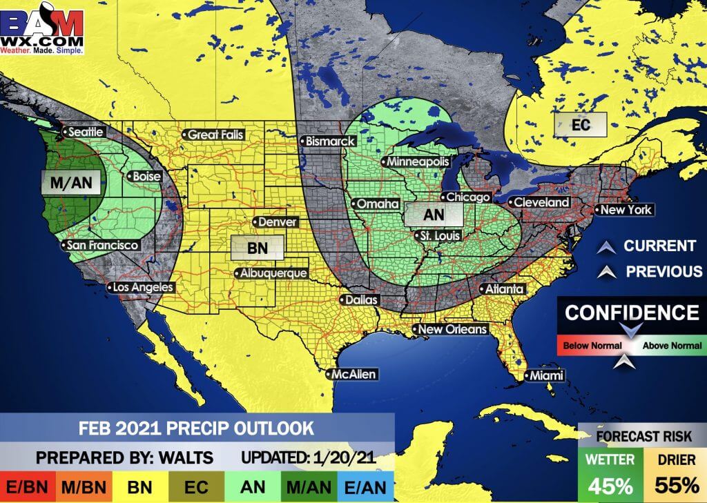
February Precipitation Outlook (preliminary)
.
And the preliminary March outlooks
Temperature departures
Precipitation
.
![]()

Great news! The videos are now found in your Weathertalk app and on the WeatherTalk website.
These are bonus videos for subscribers.
The app is for subscribers. Subscribe at www.weathertalk.com/welcome then go to your app store and search for WeatherTalk
Subscribers, PLEASE USE THE APP. ATT and Verizon are not reliable during severe weather. They are delaying text messages.
The app is under WeatherTalk in the app store.

Apple users click here

Android users click here
.

Radar Link: Interactive local city-view radars & regional radars.
You will find clickable warning and advisory buttons on the local city-view radars.
If the radar is not updating then try another one. If a radar does not appear to be refreshing then hit Ctrl F5. You may also try restarting your browser.
Not working? Email me at beaudodson@usawx.com
National map of weather watches and warnings. Click here.
Storm Prediction Center. Click here.
Weather Prediction Center. Click here.
.

Live lightning data: Click here.
.

Interactive GOES R satellite. Track clouds. Click here.
GOES 16 slider tool. Click here.
College of Dupage satellites. Click here
.

Here are the latest local river stage forecast numbers Click Here.
Here are the latest lake stage forecast numbers for Kentucky Lake and Lake Barkley Click Here.
.
.
Find Beau on Facebook! Click the banner.


 .
.