
Click one of the links below to take you directly to that section
![]()
![]()
![]()
![]()
![]()
![]()
![]()
Do you have any suggestions or comments? Email me at beaudodson@usawx.com
Seven-day forecast for southeast Missouri, southern Illinois, western Kentucky, and western Tennessee.
This is a BLEND for the region. Scroll down to see the region by region forecast.
THE FORECAST IS GOING TO VARY FROM LOCATION TO LOCATION. Scroll down to see the region by region forecast.
——————–
Good day, everyone. An active weather pattern over the next seven days.
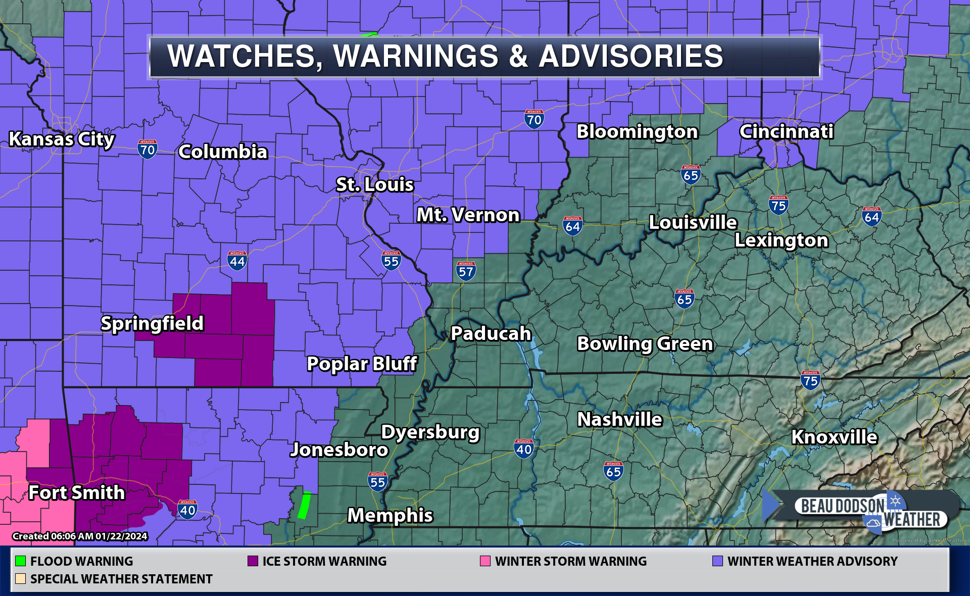
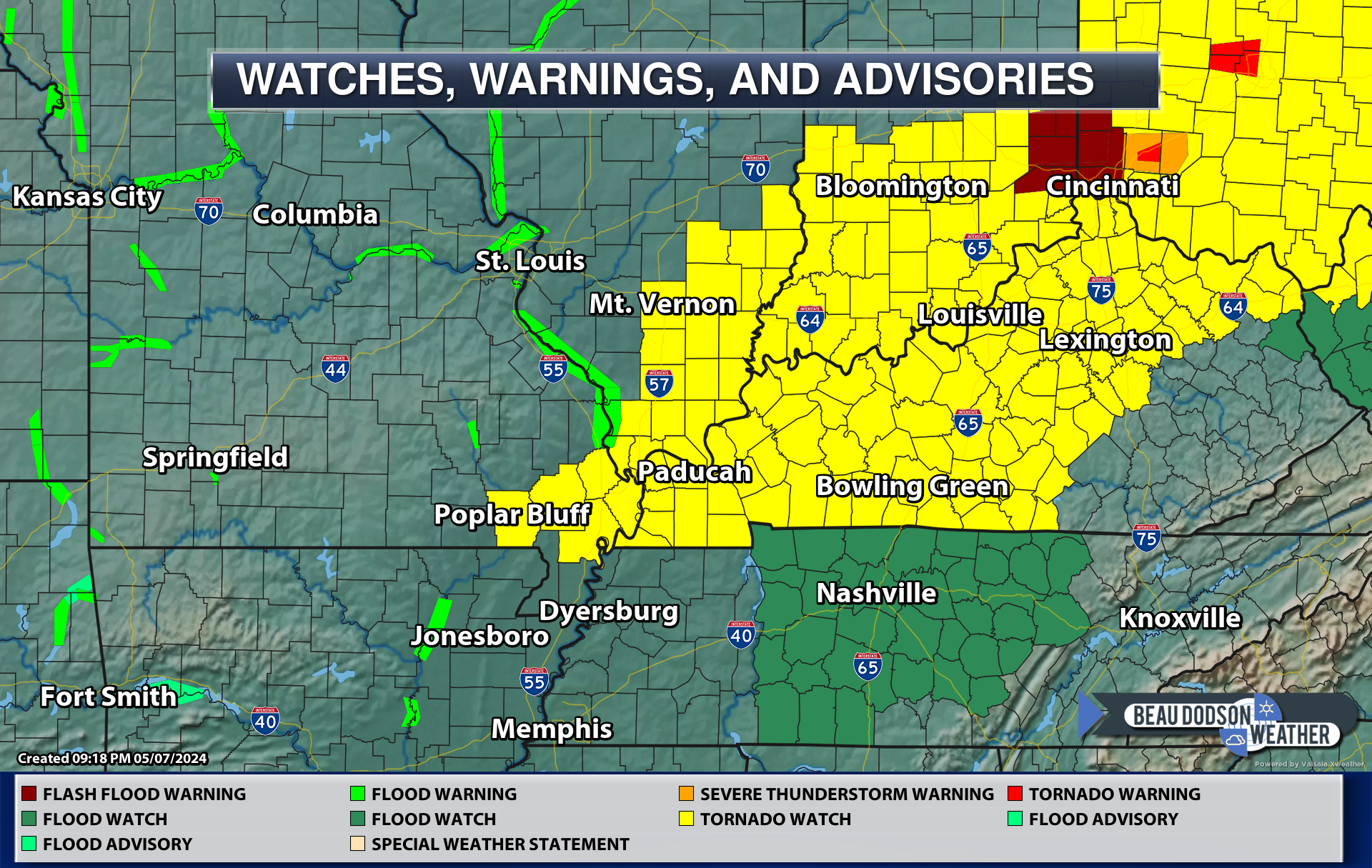
––> WINTER WEATHER ADVISORY REMAINS IN EFFECT UNTIL 10 PM CST TONIGHT FOR PORTIONS OF SOUTHEAST MISSOURI AND SOUTHWEST ILLINOIS.
CLICK HERE FOR UPDATED ADVISORY MAP (adjustments are possible)
https://imagery.weathertalk.com/prx/Region_Alerts.png
WHAT…Freezing rain expected. Total ice accumulations up to one tenth of an inch.
WHERE…Portions of south central, southwest, and west central Illinois and central, east central, northeast, and southeast Missouri.
WHEN…Until 10 PM tonight.
IMPACTS…Difficult travel conditions are possible. Icy conditions are likely to impact the Monday morning commute and could impact the evening commute as well.
PRECAUTIONARY/PREPAREDNESS
ACTIONS… Slow down and use caution while traveling. Prepare for possible power outages.
Don’t forget JP has a traffic app, as well. See that here https://jpstraffic.com/welcome

In Illinois, the latest road conditions can be obtained at www.gettingaroundillinois.com.
In Missouri, the latest road conditions can be obtained at traveler.modot.org/map or by calling 1-888-275-6636.
DOUBLE CLICK IMAGES ON THE BLOG TO ENLARGE THEM.
SEE THE VIDEOS IN YOUR APP, AS WELL
Here is the probability of freezing rain. As you can see, it is mainly our western counties in Missouri and southwest Illinois. There remain some questions on when temperatures will rise above freezing with this event.
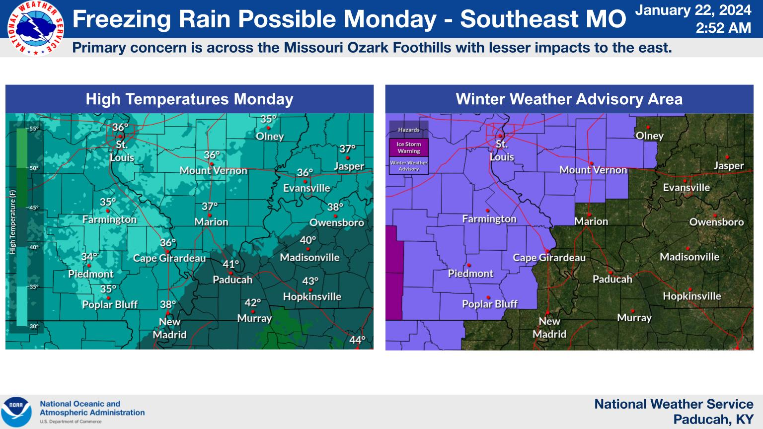
This map was created by the Paducah, Kentucky, NWS. See other NWS maps below this one.

A wet week ahead of us! Another Paducah, Kentucky NWS graphic.
Double click images to enlarge them.


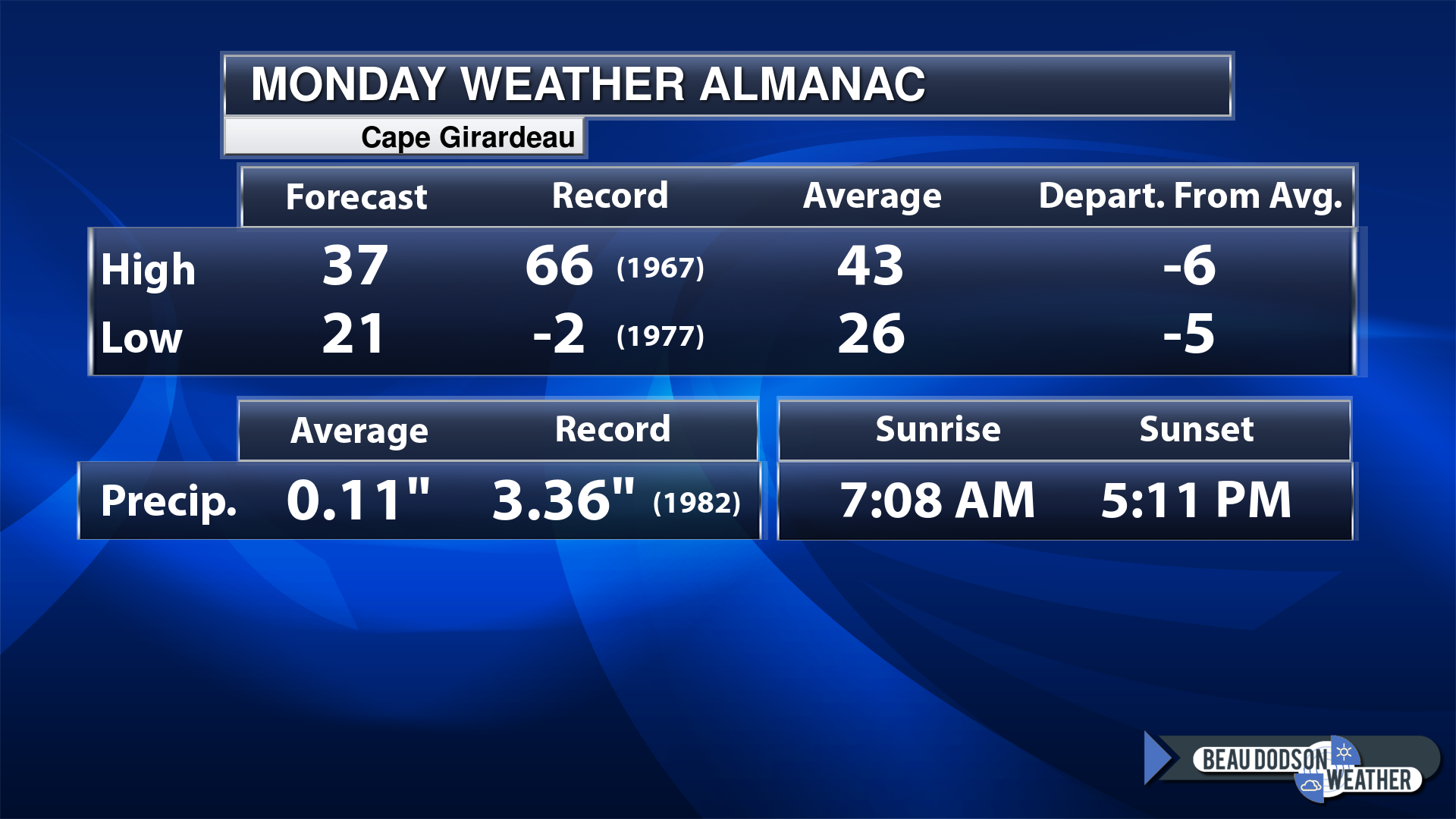
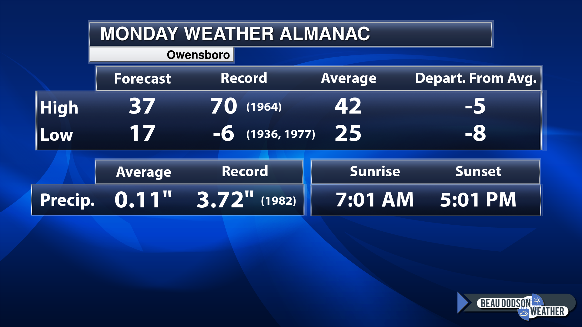
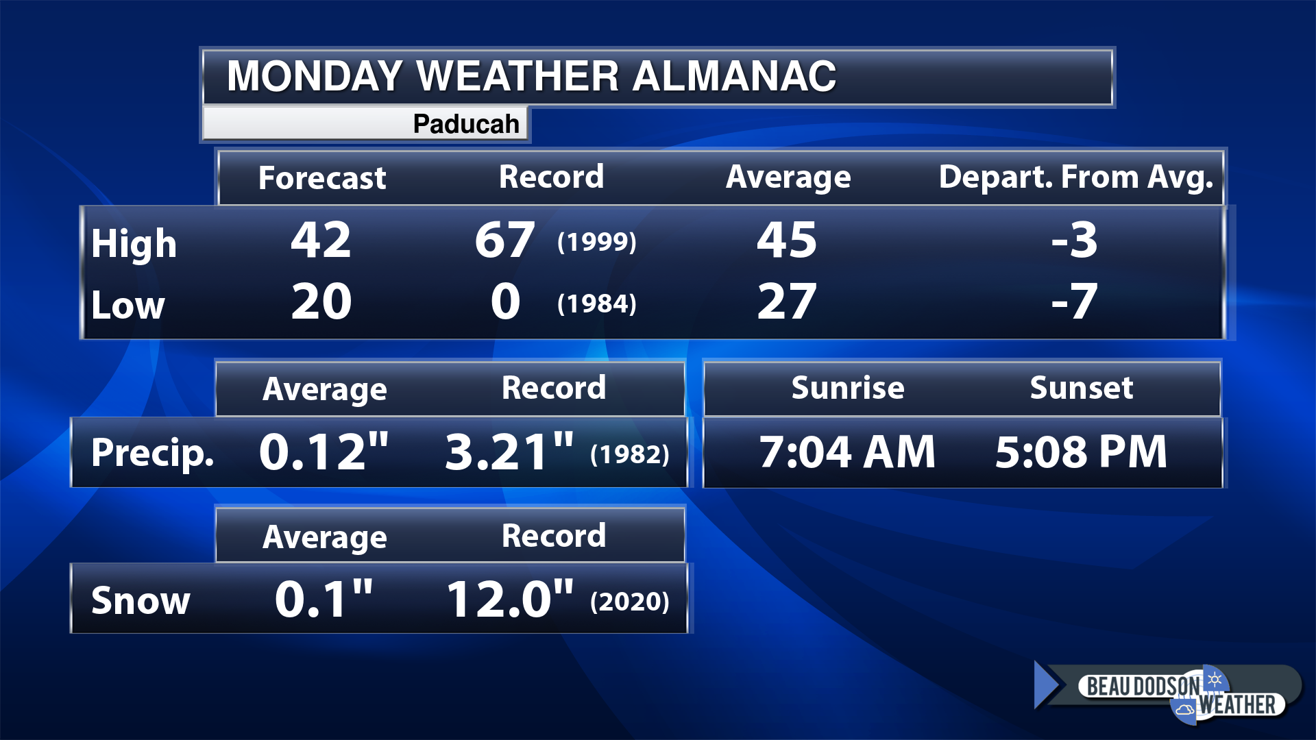
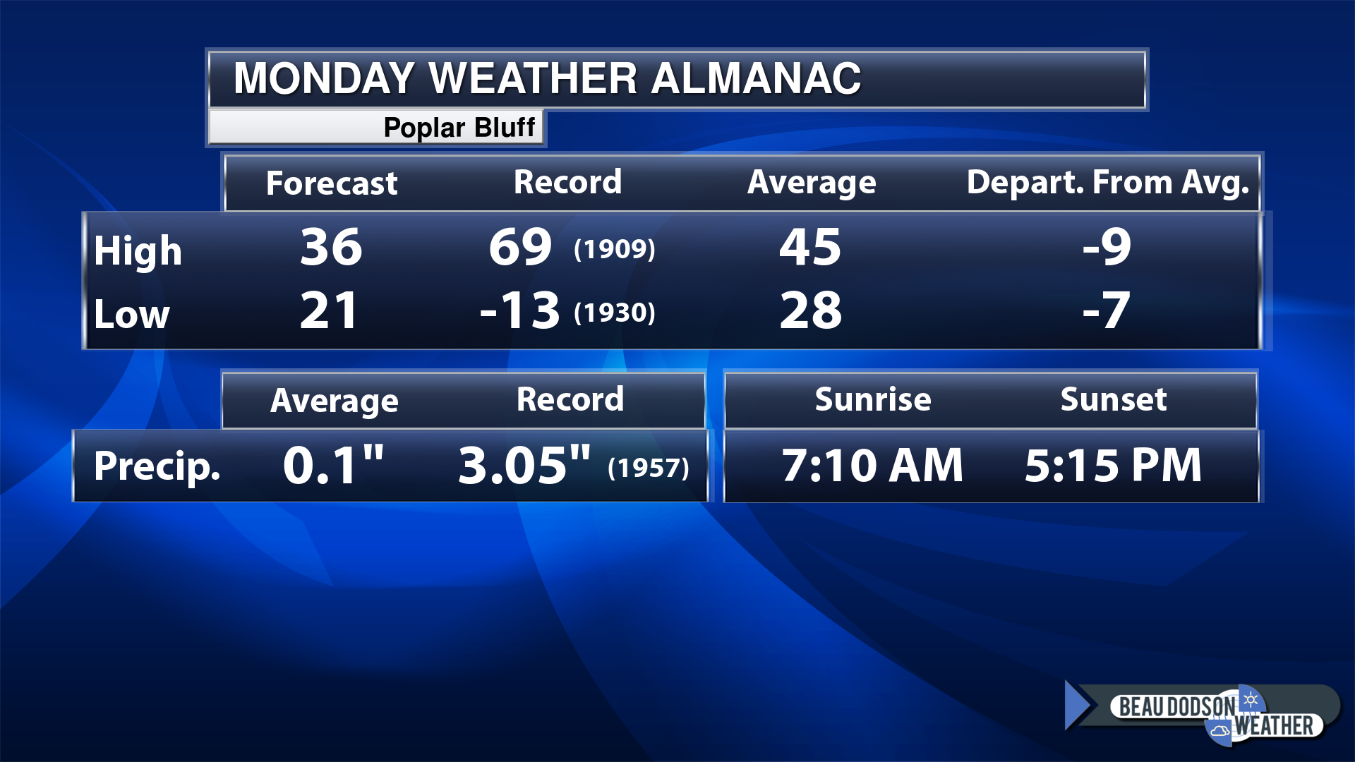
Today’s Local Almanacs (for a few select cities). Your location will be comparable.
Note, the low is this morning’s low and not tomorrows.
Today’s almanac numbers from a few select local cities.
The forecast temperature shows you today’s expected high and this morning’s low.
The graphic shows you the record high and record low for today. It shows you what year that occurred, as well.
It then shows you what today’s average temperature is.
Then, it shows you the departures (how may degrees above or below average temperatures will be ).
It shows you the average precipitation for today. Average comes from thirty years of rain totals.
It also shows you the record rainfall for the date and what year that occurred.
The sunrise and sunset are also shown.
If you have not subscribed to my YouTube Channel then click on this link and it will take you to my videos.
Click the button below and it will take you to the Beau Dodson YouTube Channel.

![]()
48-hour forecast


.

.
Monday to Monday
1. Is lightning in the forecast? YES. Lighting is possible Wednesday and Thursday. I will monitor Saturday.
2. Are severe thunderstorms in the forecast? NOT AT THIS TIME.
3. Is flash flooding in the forecast? MONITOR. Locally moderate to heavy rain is possible this week. A widespread one to two inches. Locally two to three inches. This could lead to standing water, low land flooding, and nuisance flooding in areas that commonly flood during moderate rain events.
4. Will the heat index exceed 100 degrees? NO.
5. Will the wind chill dip below 10 degrees? NO.
6. Is measurable snow and/or sleet in the forecast? NOT AT THIS TIME.
7. Is freezing rain/ice in the forecast? YES. Freezing rain is likely today across portions of southeast MO and southern IL. Rain will develop over KY and TN.
Freezing rain is rain that falls and instantly freezes on objects such as trees and power lines Freezing fog possible, as well.
.
Fire weather risk level.
Monday: 4. Low risk.
Monday night. 2. Very low risk.
Tuesday through Wednesday: 2. Very low risk. A lot of rain in the region.
Fire Weather Discussion
Freezing rain will enter southeast Missouri this morning and transition to rain as it moves east across the rest of the area through tonight. Some icing may cause impacts across the Missouri Ozark Foothills through this afternoon before temperatures rise above freezing by the evening. Much warmer temperatures are expected Wednesday through Friday with highs in the 50s and even low 60s in some areas. Unfortunately it also looks quite wet with waves of rain moving across the area through Thursday. Amounts of 1 to 3 inches are possible.
A Haines Index of 6 means a high potential for an existing fire to become large or exhibit erratic fire behavior, 5 means medium potential, 4 means low potential, and anything less than 4 means very low potential.
.

.
Monday, January 22, 2024
Confidence in the forecast? High Confidence
Monday Forecast: Mostly cloudy. A chance of freezing rain over portions of southeast Missouri and southwest Illinois. Most likely rain, elsewhere.
What is the chance of precipitation?
Far northern southeast Missouri ~ 100%
Southeast Missouri ~ 90%
The Missouri Bootheel ~ 80%
I-64 Corridor of southern Illinois ~ 100%
Southern Illinois ~ 90%
Extreme southern Illinois (southern seven counties) ~ 90%
Far western Kentucky (Purchase area) ~ 60%
The Pennyrile area of western KY ~ 40%
Northwest Kentucky (near Indiana border) ~ 60%
Northwest Tennessee ~ 40%
Coverage of precipitation: Numerous west. Scattered east.
Timing of the precipitation: Any given point of time over our western counties. Afternoon farther east. Precipitation will arrive from Arkansas and Missouri.
Far northern southeast Missouri ~ 33° to 36°
Southeast Missouri ~ 33° to 36°
The Missouri Bootheel ~ 35° to 40°
I-64 Corridor of southern Illinois ~ 33° to 36°
Southern Illinois ~ 34° to 38°
Extreme southern Illinois (southern seven counties) ~ 34° to 38°
Far western Kentucky ~ 36° to 38°
The Pennyrile area of western KY ~ 38° to 42°
Northwest Kentucky (near Indiana border) ~ 34° to 36°
Northwest Tennessee ~ 36° to 40°
Winds will be from this direction: South 7 to 14 mph with higher gusts.
Wind chill or heat index (feels like) temperature forecast: 25° to 35°
What impacts are anticipated from the weather? Icy roadways in the winter weather advisory zone. Otherwise, wet roadways.
Should I cancel my outdoor plans? Monitor the Beau Dodson Weather Radars and have a plan B in the rain zone.
UV Index: 1. Low
Sunrise: 7:06 AM
Sunset: 5:08 PM .
.
Monday Night Forecast: Cloudy. A chance of rain. A chance of freezing rain over southeast Missouri and southwest Illinois.
What is the chance of precipitation?
Far northern southeast Missouri ~ 100%
Southeast Missouri ~ 100%
The Missouri Bootheel ~ 100%
I-64 Corridor of southern Illinois ~ 90%
Southern Illinois ~ 100%
Extreme southern Illinois (southern seven counties) ~ 100%
Far western Kentucky (Purchase area) ~ 100%
The Pennyrile area of western KY ~ 100%
Northwest Kentucky (near Indiana border) ~ 100%
Northwest Tennessee ~ 90%
Coverage of precipitation: Widespread
Timing of the precipitation: Any given point of time.
Temperature range:
Far northern southeast Missouri 32° to 34°
Southeast Missouri ~ 33° to 36°
The Missouri Bootheel ~ 34° to 36°
I-64 Corridor of southern Illinois ~ 32° to 34°
Southern Illinois ~ 33° to 36°
Extreme southern Illinois (southern seven counties) ~ 33° to 36°
Far western Kentucky ~ 34° to 36°
The Pennyrile area of western KY ~ 34° to 38°
Northwest Kentucky (near Indiana border) ~ 33° to 36°
Northwest Tennessee ~ 34° to 38°
Winds will be from this direction: South southeast 10 to 20 mph.
Wind chill or heat index (feels like) temperature forecast: 25° to 35°
What impacts are anticipated from the weather? Wet roadways. Icy roadways.
Should I cancel my outdoor plans? Have a plan B.
Moonrise: 2:09 PM
Moonset: 4:58 AM
The phase of the moon: Waxing Gibbous
.
Tuesday, January 23, 2024
Confidence in the forecast? High Confidence
Tuesday Forecast: Cloudy with rain likely.
What is the chance of precipitation?
Far northern southeast Missouri ~ 80%
Southeast Missouri ~ 80%
The Missouri Bootheel ~ 80%
I-64 Corridor of southern Illinois ~ 80%
Southern Illinois ~ 80%
Extreme southern Illinois (southern seven counties) ~ 80%
Far western Kentucky (Purchase area) ~ 80%
The Pennyrile area of western KY ~ 80%
Northwest Kentucky (near Indiana border) ~ 80%
Northwest Tennessee ~ 80%
Coverage of precipitation: Numerous.
Timing of the precipitation: Any given point of time
Far northern southeast Missouri ~ 44° to 48°
Southeast Missouri ~ 44° to 48°
The Missouri Bootheel ~ 44° to 48°
I-64 Corridor of southern Illinois ~ 43° to 46°
Southern Illinois ~ 44° to 48°
Extreme southern Illinois (southern seven counties) ~ 44° to 48°
Far western Kentucky ~ 44° to 48°
The Pennyrile area of western KY ~ 48° to 50°
Northwest Kentucky (near Indiana border) ~ 44° to 48°
Northwest Tennessee ~ 44° to 48°
Winds will be from this direction: South southeast at 7 to 14 mph
Wind chill or heat index (feels like) temperature forecast: 42° to 46°
What impacts are anticipated from the weather? Wet roadways.
Should I cancel my outdoor plans? Monitor the Beau Dodson Weather Radars and have a plan B
UV Index: 1. Low
Sunrise: 7:05 AM
Sunset: 5:10 PM .
.
Tuesday Night Forecast: Cloudy. A chance of rain.
What is the chance of precipitation?
Far northern southeast Missouri ~ 80%
Southeast Missouri ~ 80%
The Missouri Bootheel ~ 80%
I-64 Corridor of southern Illinois ~ 80%
Southern Illinois ~ 80%
Extreme southern Illinois (southern seven counties) ~ 80%
Far western Kentucky (Purchase area) ~ 80%
The Pennyrile area of western KY ~ 80%
Northwest Kentucky (near Indiana border) ~ 80%
Northwest Tennessee ~ 80%
Coverage of precipitation: Widespread
Timing of the precipitation: Any given point of time.
Temperature range:
Far northern southeast Missouri 38° to 40°
Southeast Missouri ~ 38° to 40°
The Missouri Bootheel ~ 40° to 42°
I-64 Corridor of southern Illinois ~ 38° to 40°
Southern Illinois ~ 40° to 42°
Extreme southern Illinois (southern seven counties) ~ 40° to 42°
Far western Kentucky ~ 43° to 46°
The Pennyrile area of western KY ~ 44° to 48°
Northwest Kentucky (near Indiana border) ~ 44° to 46°
Northwest Tennessee ~ 44° to 48°
Winds will be from this direction: South southeast 10 to 20 mph.
Wind chill or heat index (feels like) temperature forecast: 35° to 40°
What impacts are anticipated from the weather? Wet roadways.
Should I cancel my outdoor plans? Have a plan B.
Moonrise: 3:05 PM
Moonset: 5:55 AM
The phase of the moon: Waxing Gibbous
.
Wednesday, January 24, 2024
Confidence in the forecast? High Confidence
Wednesday Forecast: Cloudy with rain likely. A chance of thunderstorms. The chance of thunderstorms will be focused from the Missouri Bootheel into west Tennessee and then into western Kentucky.
What is the chance of precipitation?
Far northern southeast Missouri ~ 60%
Southeast Missouri ~ 60%
The Missouri Bootheel ~ 80%
I-64 Corridor of southern Illinois ~ 60%
Southern Illinois ~ 60%
Extreme southern Illinois (southern seven counties) ~ 70%
Far western Kentucky (Purchase area) ~ 80%
The Pennyrile area of western KY ~ 80%
Northwest Kentucky (near Indiana border) ~ 80%
Northwest Tennessee ~ 80%
Coverage of precipitation: Numerous.
Timing of the precipitation: Any given point of time
Far northern southeast Missouri ~ 50° to 52°
Southeast Missouri ~ 52° to 54°
The Missouri Bootheel ~ 54° to 56°
I-64 Corridor of southern Illinois ~ 52° to 54°
Southern Illinois ~ 52° to 54°
Extreme southern Illinois (southern seven counties) ~ 53° to 56°
Far western Kentucky ~ 53° to 56°
The Pennyrile area of western KY ~ 54° to 56°
Northwest Kentucky (near Indiana border) ~ 54° to 58°
Northwest Tennessee ~ 54° to 58°
Winds will be from this direction: East becoming southeast 10 to 20 mph.
Wind chill or heat index (feels like) temperature forecast: 46° to 54°
What impacts are anticipated from the weather? Wet roadways. Lightning.
Should I cancel my outdoor plans? Monitor the Beau Dodson Weather Radars and have a plan B
UV Index: 1. Low
Sunrise: 7:04 AM
Sunset: 5:11 PM .
.
Wednesday Night Forecast: Cloudy. A chance of showers and thunderstorms.
What is the chance of precipitation?
Far northern southeast Missouri ~ 80%
Southeast Missouri ~ 80%
The Missouri Bootheel ~ 80%
I-64 Corridor of southern Illinois ~ 80%
Southern Illinois ~ 80%
Extreme southern Illinois (southern seven counties) ~ 80%
Far western Kentucky (Purchase area) ~ 80%
The Pennyrile area of western KY ~ 80%
Northwest Kentucky (near Indiana border) ~ 80%
Northwest Tennessee ~ 80%
Coverage of precipitation: Widespread
Timing of the precipitation: Any given point of time.
Temperature range:
Far northern southeast Missouri 38° to 42°
Southeast Missouri ~ 40° to 44°
The Missouri Bootheel ~ 44° to 48°
I-64 Corridor of southern Illinois ~ 38° to 42°
Southern Illinois ~ 40° to 44°
Extreme southern Illinois (southern seven counties) ~ 42° to 45
Far western Kentucky ~ 45° to 50°
The Pennyrile area of western KY ~ 50° to 54°
Northwest Kentucky (near Indiana border) ~ 52° to 55°
Northwest Tennessee ~ 52° to 55°
Winds will be from this direction: South southeast 10 to 20 mph.
Wind chill or heat index (feels like) temperature forecast: 35° to 52° Colder northwest. Milder southeast.
What impacts are anticipated from the weather? Wet roadways. Lightning.
Should I cancel my outdoor plans? Have a plan B.
Moonrise: 4:06 PM
Moonset: 6:43 AM
The phase of the moon: Full
.
Thursday, January 25, 2024
Confidence in the forecast? High Confidence
Thursday Forecast: Cloudy with rain likely. A chance of thunderstorms.
What is the chance of precipitation?
Far northern southeast Missouri ~ 70%
Southeast Missouri ~ 70%
The Missouri Bootheel ~ 80%
I-64 Corridor of southern Illinois ~ 60%
Southern Illinois ~ 70%
Extreme southern Illinois (southern seven counties) ~ 70%
Far western Kentucky (Purchase area) ~ 70%
The Pennyrile area of western KY ~ 80%
Northwest Kentucky (near Indiana border) ~ 80%
Northwest Tennessee ~ 80%
Coverage of precipitation: Numerous.
Timing of the precipitation: Any given point of time
Far northern southeast Missouri ~ 54° to 56°
Southeast Missouri ~ 52° to 54°
The Missouri Bootheel ~ 54° to 56°
I-64 Corridor of southern Illinois ~ 52° to 54°
Southern Illinois ~ 53° to 56°
Extreme southern Illinois (southern seven counties) ~ 54° to 56°
Far western Kentucky ~ 54° to 56°
The Pennyrile area of western KY ~ 58° to 62°
Northwest Kentucky (near Indiana border) ~ 55° to 60°
Northwest Tennessee ~ 56° to 60°
Winds will be from this direction: Becoming southwest 10 to 20 mph.
Wind chill or heat index (feels like) temperature forecast: 50° to 55°
What impacts are anticipated from the weather? Wet roadways. Lightning.
Should I cancel my outdoor plans? Monitor the Beau Dodson Weather Radars and have a plan B
UV Index: 2. Low
Sunrise: 7:04 AM
Sunset: 5:12 PM .
.
Thursday Night Forecast: Cloudy. A chance of showers.
What is the chance of precipitation?
Far northern southeast Missouri ~ 30%
Southeast Missouri ~ 30%
The Missouri Bootheel ~ 30%
I-64 Corridor of southern Illinois ~ 30%
Southern Illinois ~ 40%
Extreme southern Illinois (southern seven counties) ~ 40%
Far western Kentucky (Purchase area) ~ 40%
The Pennyrile area of western KY ~ 40%
Northwest Kentucky (near Indiana border) ~ 40%
Northwest Tennessee ~ 40%
Coverage of precipitation: Scattered
Timing of the precipitation: Any given point of time.
Temperature range:
Far northern southeast Missouri 38° to 42°
Southeast Missouri ~ 40° to 42°
The Missouri Bootheel ~ 42° to 45°
I-64 Corridor of southern Illinois ~ 38° to 40°
Southern Illinois ~ 38° to 42°
Extreme southern Illinois (southern seven counties) ~ 42° to 45
Far western Kentucky ~ 42° to 44°
The Pennyrile area of western KY ~ 42° to 44°
Northwest Kentucky (near Indiana border) ~ 42° to 44°
Northwest Tennessee ~ 42° to 44°
Winds will be from this direction: West 8 to 16 mph.
Wind chill or heat index (feels like) temperature forecast: 30° to 40°
What impacts are anticipated from the weather? Wet roadways.
Should I cancel my outdoor plans? Monitor updates.
Moonrise: 5:09 PM
Moonset: 7:23 AM
The phase of the moon: Full
.
.
Click here if you would like to return to the top of the page.

-
- Freezing rain chances today. Ending tonight.
- Widespread showers and thunderstorms this week with milder temperatures.
- Some areas will hit SIXTY degrees!
- Widespread one to three inches of rain.
- Thunderstorms possible. Low level risk of flooding.
- Monitoring a weekend storm system.
Weather advice:
Make sure you have three to five ways of receiving your severe weather information.
Watch for icy surfaces Monday. Mainly over portions of southeast Missouri and southern Illinois.
Forecast Discussion
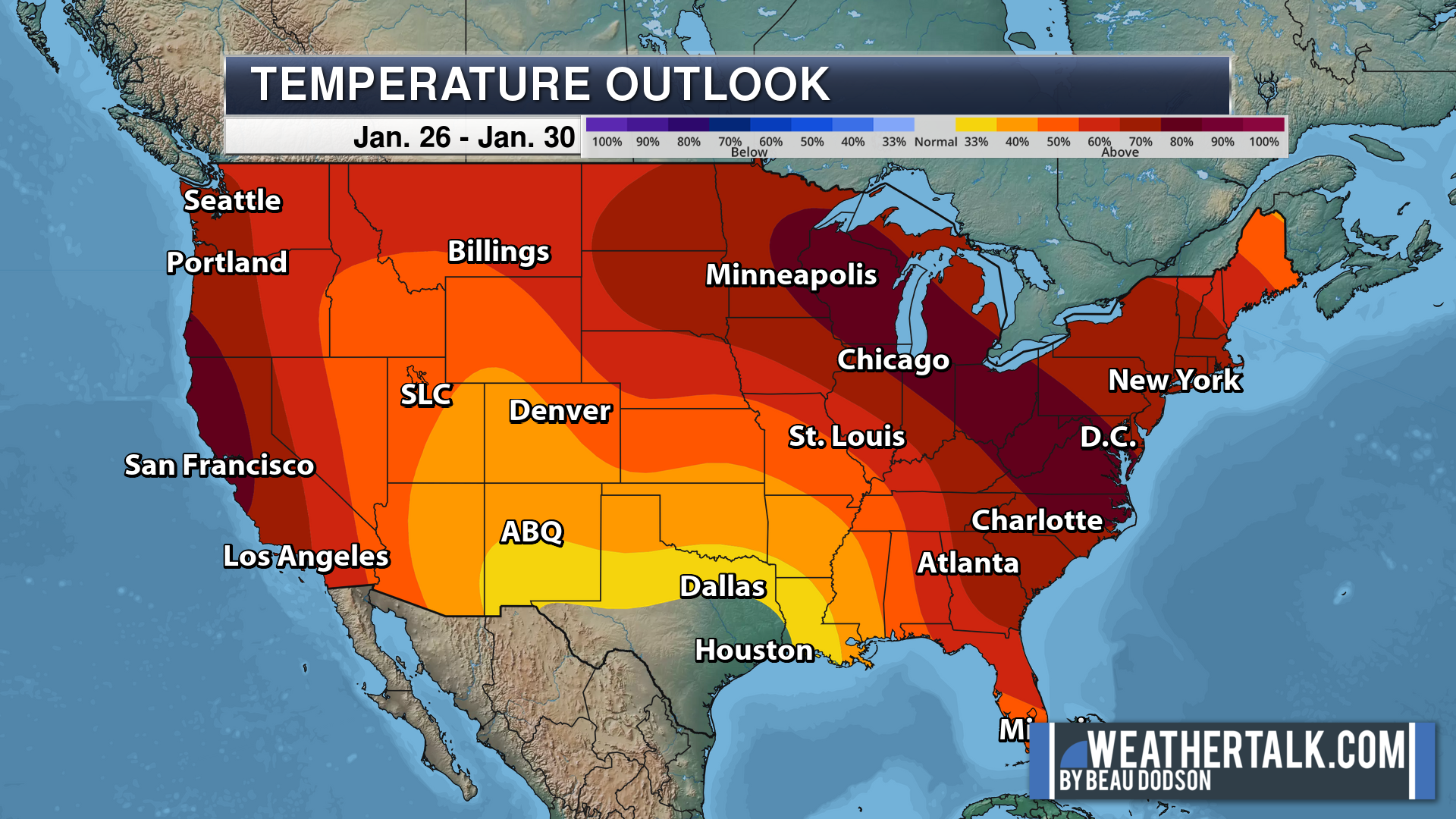
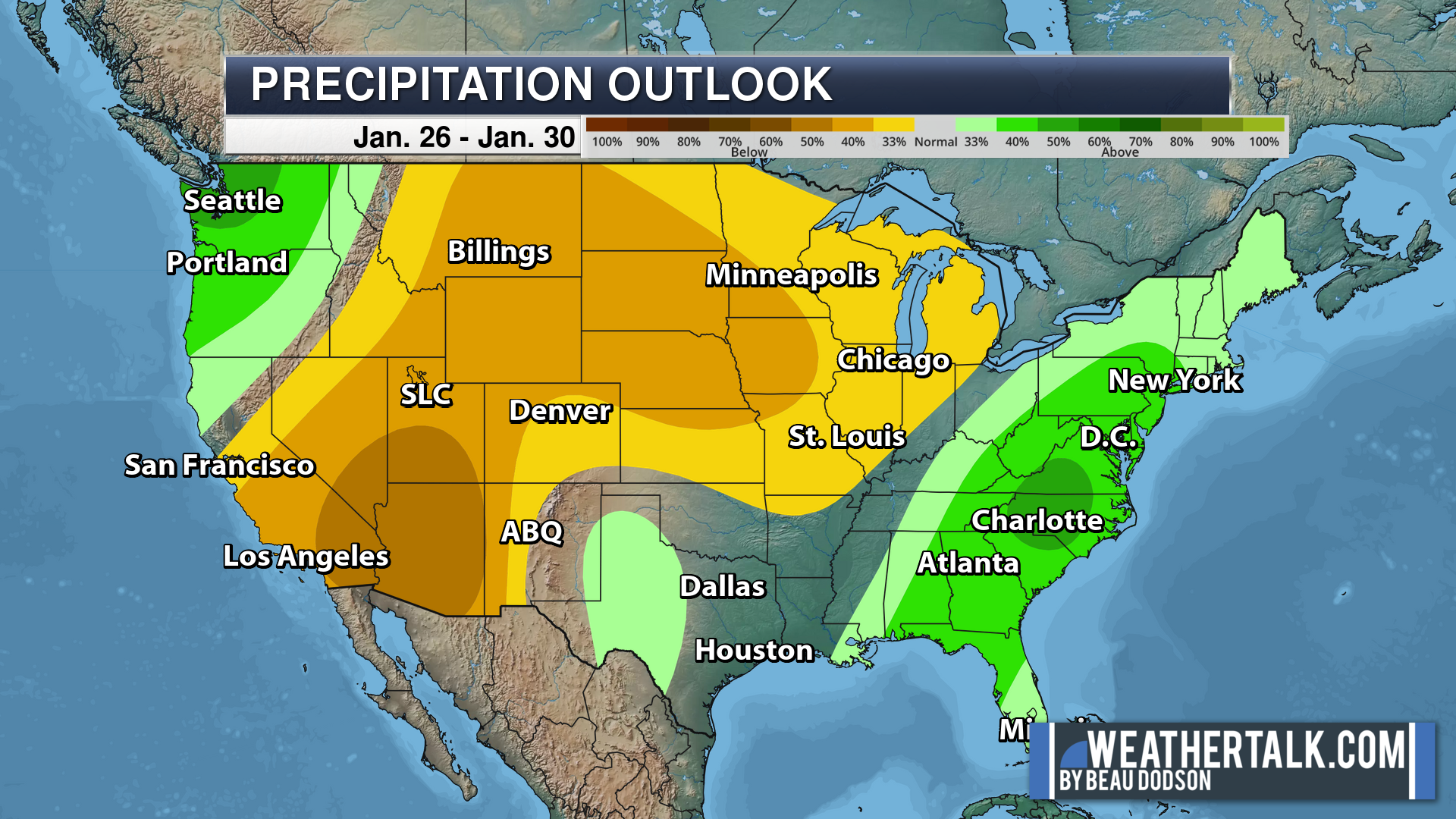
An active weather pattern will continue into next weekend. Numerous days with rain. Some thunderstorms, as well.
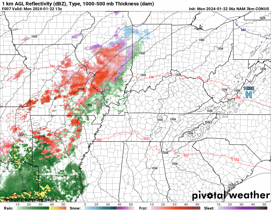
An ice event is likely today from western Arkansas into Missouri and Illinois.
This ice event will impact some of our local counties. Thankfully, ice totals in our local area are expected to be low enough to prevent tree and power line damage.
Keep in mind, it only takes a hint of freezing rain to cause travel issues. Roadways are cold. Surfaces are cold.
At this time, the primary concern will be across portions of southeast Missouri and southwest Illinois. The NWS has issued a winter weather advisory in the area with the highest risk of impacts.
Here is what radar looked like at 7 AM. Most of that is freezing rain.

Rain Rain Rain
We will be dealing with daily rain chances into at least Saturday. There will be peak time periods with higher rain probabilities. See the daily forecast at the top of the blog.
A widespread one to two inches of rain will impact the region. Locally two to three inches.
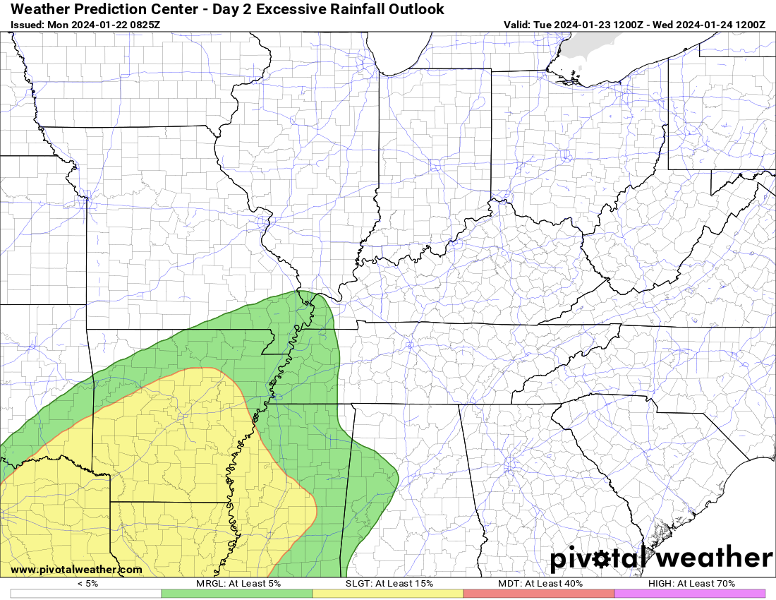
Here is the latest WPC rainfall graphic. This covers the next seven days.
Welcome to mud season! This rain will help the drought stricken southlands. They have been dealing with severe drought for months.

The ground is frozen. This kind of rain, especially where thunderstorms occur, could lead to standing water and flooding. I don’t expect widespread flash flooding, but low land flooding will be common. I expect nuisance flooding in areas that commonly experience issues with this type of weather.
We will have to see if the NWS issues flood watches or warnings/advisories. That would be more likely Wednesday and Thursday with the thunderstorms.
The WPC NOAA has placed portions of the region in a low level risk of flash flooding Tuesday and Wednesday. I suspect this may continue into Thursday. Their graphics don’t go out that far.
Wednesday
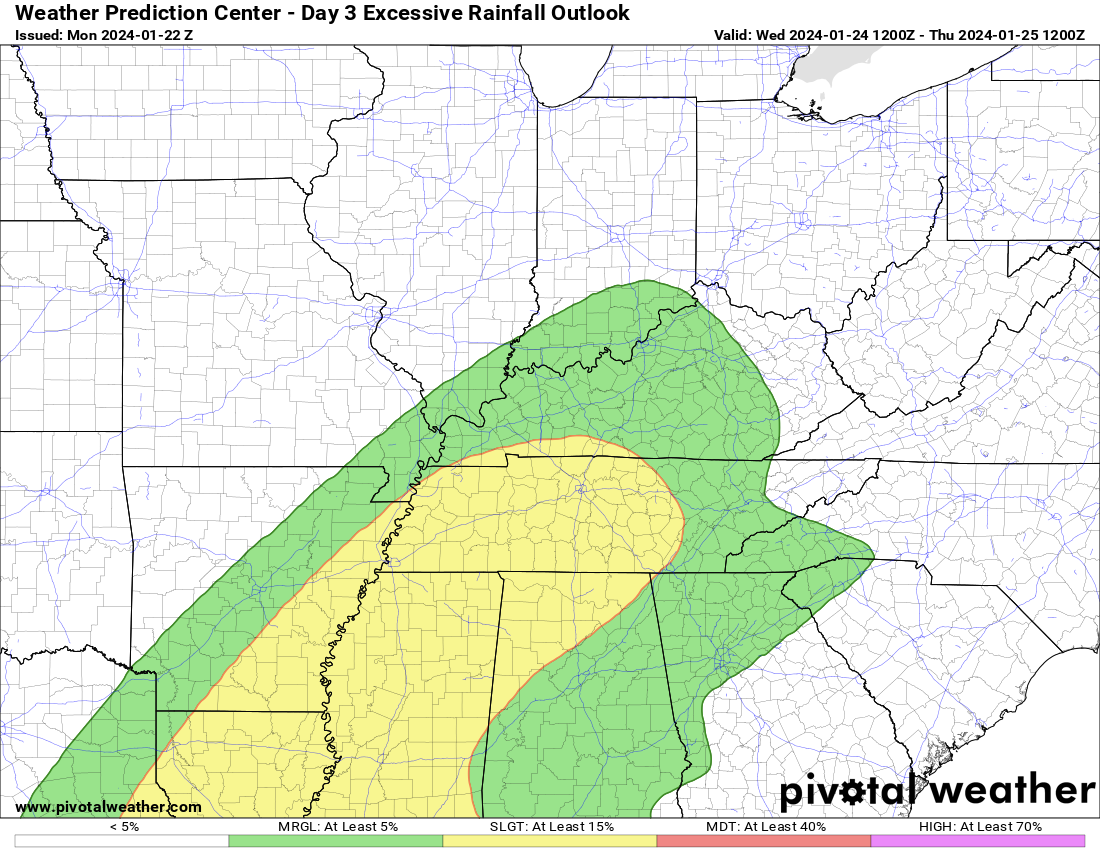
Thunderstorms will enhance rain totals Wednesday and Thursday. The risk of thunderstorms is higher from the Missouri Bootheel into Tennessee and Kentucky.
At this time, severe thunderstorms are not anticipated. Monitor updates, as always.
It won’t rain all the time. On and off chances all week. See the future-cast radars below.
I am watching the track of a weekend storm system. The low is forecast to track south and east of our area. That places us in the cooler section. At times, models have shown a chance of snow.
For now, I have rain in the forecast. But, I will monitor it closely.
We have about eight weeks of snow season left. I doubt we are finished with cold wintry weather. I know some of you still one more snow. I love snow, but I am not a fan of what we just went through. That is a bit too much! The cold.
.
Click here if you would like to return to the top of the page.
This outlook covers southeast Missouri, southern Illinois, western Kentucky, and far northwest Tennessee.

.
Today’s Storm Prediction Center’s Severe Weather Outlook
Light green is where thunderstorms may occur but should be below severe levels.
Dark green is a level one risk. Yellow is a level two risk. Orange is a level three (enhanced) risk. Red is a level four (moderate) risk. Pink is a level five (high) risk.
One is the lowest risk. Five is the highest risk.
A severe storm is one that produces 58 mph wind or higher, quarter size hail, and/or a tornado.
Explanation of tables. Click here.

.
Tornado Probability Outlook

.
Large Hail Probability Outlook

.
High wind Probability Outlook

.
Tomorrow’s severe weather outlook.

.
Day Three Severe Weather Outlook

.

.
The images below are from NOAA’s Weather Prediction Center.
24-hour precipitation outlook..
 .
.
.
48-hour precipitation outlook.
. .
.
![]()
_______________________________________
.

Click here if you would like to return to the top of the page.
Again, as a reminder, these are models. They are never 100% accurate. Take the general idea from them.
What should I take from these?
- The general idea and not specifics. Models usually do well with the generalities.
- The time-stamp is located in the upper left corner.
.
What am I looking at?
You are looking at computer model data. Meteorologists use many different models to forecast the weather.
Occasionally, these maps are in Zulu time. 12z=7 AM. 18z=1 PM. 00z=7 PM. 06z=1 AM
Green represents light rain. Dark green represents moderate rain. Yellow and orange represent heavier rain.
.
This animation is the HRRR Model.
Occasionally, these maps are in Zulu time. 12z=6 AM. 18z=12 PM. 00z=6 PM. 06z=12 AM
Double click images to enlarge them. Blue is snow. Pink is a wintry mix. Green is rain.
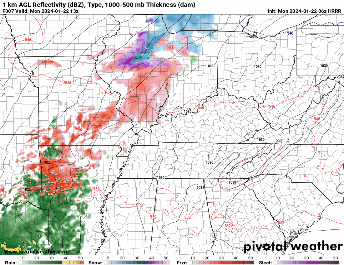
.
This animation is the NAM 3K Model.
Occasionally, these maps are in Zulu time. 12z=6 AM. 18z=12 PM. 00z=6 PM. 06z=12 AM
Double click images to enlarge them.
.
This animation is the GFS Model.
Green is rain. Yellow and orange are heavier rain. Pink is a wintry mix. Blue is snow. Dark blue is heavier snow.
Occasionally, these maps are in Zulu time. 12z=6 AM. 18z=12 PM. 00z=6 PM. 06z=12 AM
Double click images to enlarge them.

.
..![]()

.
Click here if you would like to return to the top of the page.
.Average high temperatures for this time of the year are around 42 degrees.
Average low temperatures for this time of the year are around 26 degrees.
Average precipitation during this time period ranges from 0.50″ to 1.00″
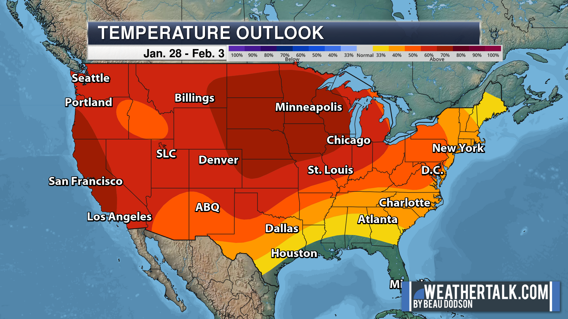
Six to Ten Day Outlook.
Blue is below average. Red is above average. The no color zone represents equal chances.
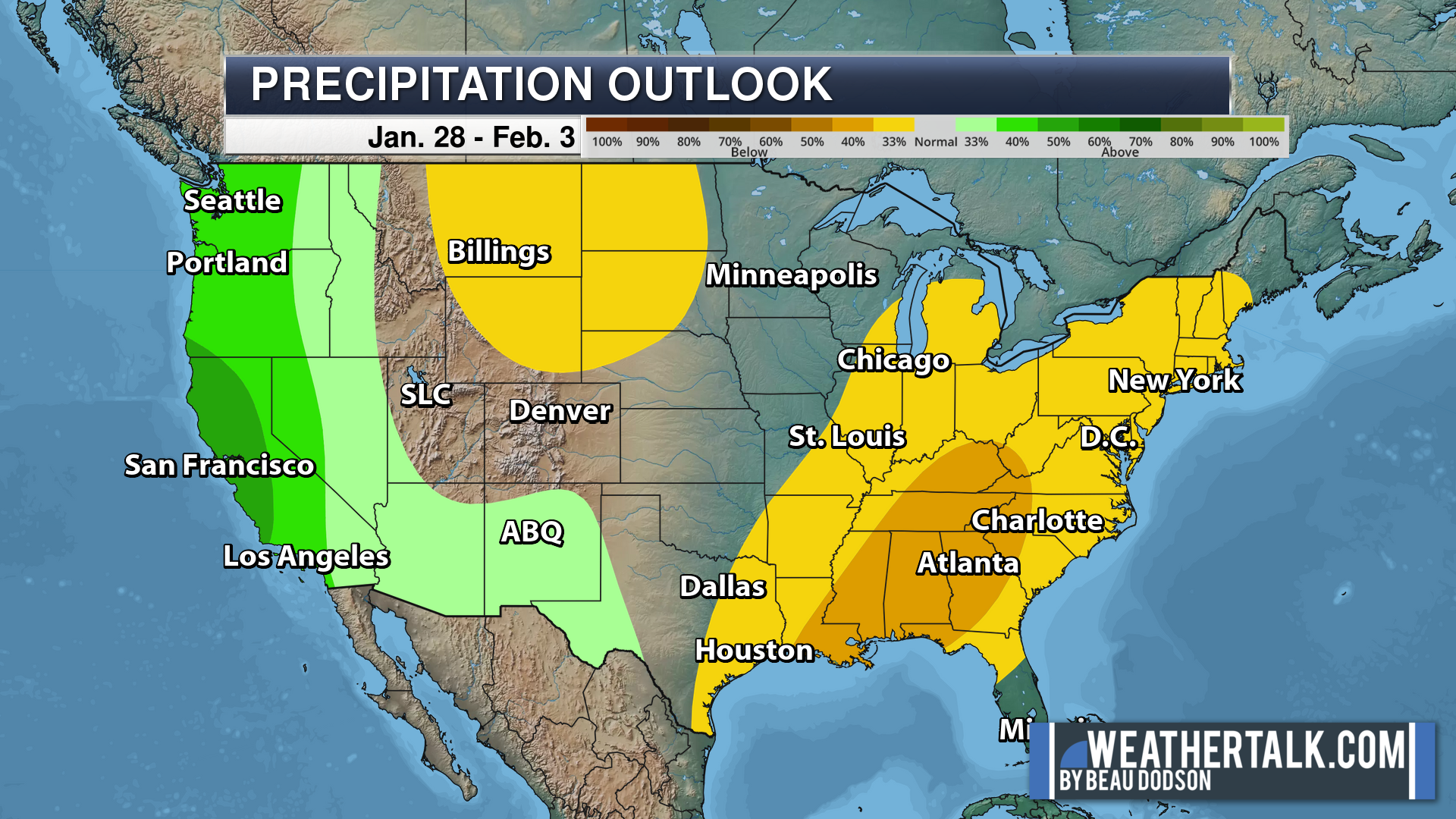
Average highs for this time of the year are in the lower 60s. Average lows for this time of the year are in the lower 40s.
Green is above average precipitation. Yellow and brown favors below average precipitation. Average precipitation for this time of the year is around one inch per week.
.

Average low temperatures for this time of the year are around 28 degrees.
Average precipitation during this time period ranges from 0.50″ to 1.00″
.
Eight to Fourteen Day Outlook.
Blue is below average. Red is above average. The no color zone represents equal chances.
Green is above average precipitation. Yellow and brown favors below average precipitation. Average precipitation for this time of the year is around one inch per week.
.
![]()
The app is for subscribers. Subscribe at www.weathertalk.com/welcome then go to your app store and search for WeatherTalk
Subscribers, PLEASE USE THE APP. ATT and Verizon are not reliable during severe weather. They are delaying text messages.
The app is under WeatherTalk in the app store.

Apple users click here

Android users click here
.

Radars and Lightning Data
Interactive-city-view radars. Clickable watches and warnings.
https://wtalk.co/B3XHASFZ
If the radar is not updating then try another one. If a radar does not appear to be refreshing then hit Ctrl F5. You may also try restarting your browser.
Backup radar site in case the above one is not working.
https://weathertalk.com/morani
Regional Radar
https://imagery.weathertalk.com/prx/RadarLoop.mp4
** NEW ** Zoom radar with chaser tracking abilities!
ZoomRadar
Lightning Data (zoom in and out of your local area)
https://wtalk.co/WJ3SN5UZ
Not working? Email me at beaudodson@usawx.com
National map of weather watches and warnings. Click here.
Storm Prediction Center. Click here.
Weather Prediction Center. Click here.
.

Live lightning data: Click here.
Real time lightning data (another one) https://map.blitzortung.org/#5.02/37.95/-86.99
Our new Zoom radar with storm chases
.
.

Interactive GOES R satellite. Track clouds. Click here.
GOES 16 slider tool. Click here.
College of DuPage satellites. Click here
.

Here are the latest local river stage forecast numbers Click Here.
Here are the latest lake stage forecast numbers for Kentucky Lake and Lake Barkley Click Here.
.
.
Find Beau on Facebook! Click the banner.


 .
.