

.
I have some question-and-answer threads over on the Facebook page. Link to those threads CLICK HERE
Or email me at beaudodsonweather@gmail.com
..

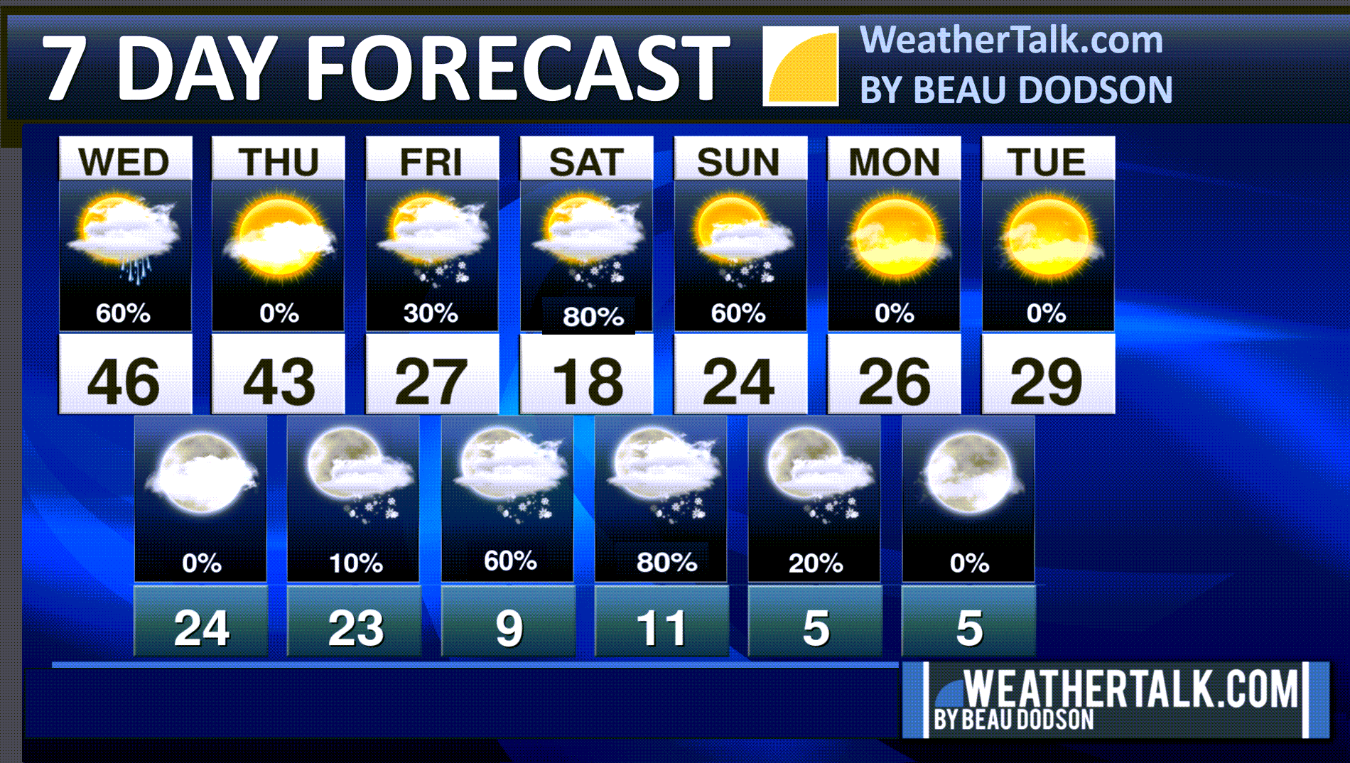
🌪️ Seven-Day Tornado Outlook ⛈️
January 21st through January 27th
Current risk: No concerns.
Current confidence level: High confidence.
Comments: Severe weather is not anticipated.
.

Seven-Day Hazardous Weather Outlook
1. Is lightning in the forecast? NO.
2. Are organized/widespread severe thunderstorms in the forecast? NO.
..3. Is significant or widespread flash flooding in the forecast? NO.
4. Will non-thunderstorm winds top 40 mph? NO.
5. Will the temperature fall below 20 degrees? YES. Friday night through at least Monday night.
6. Is the wind chill forecast to drop below ten degrees? YES. Friday night through Monday.
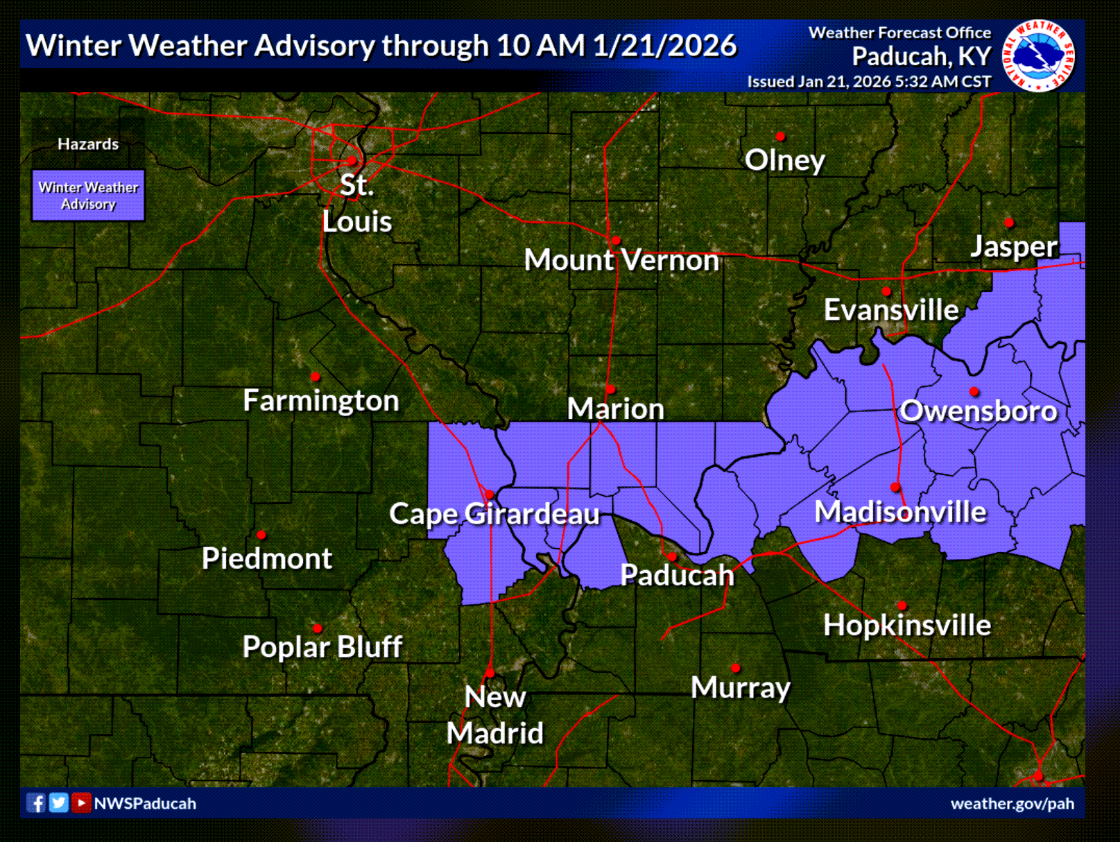
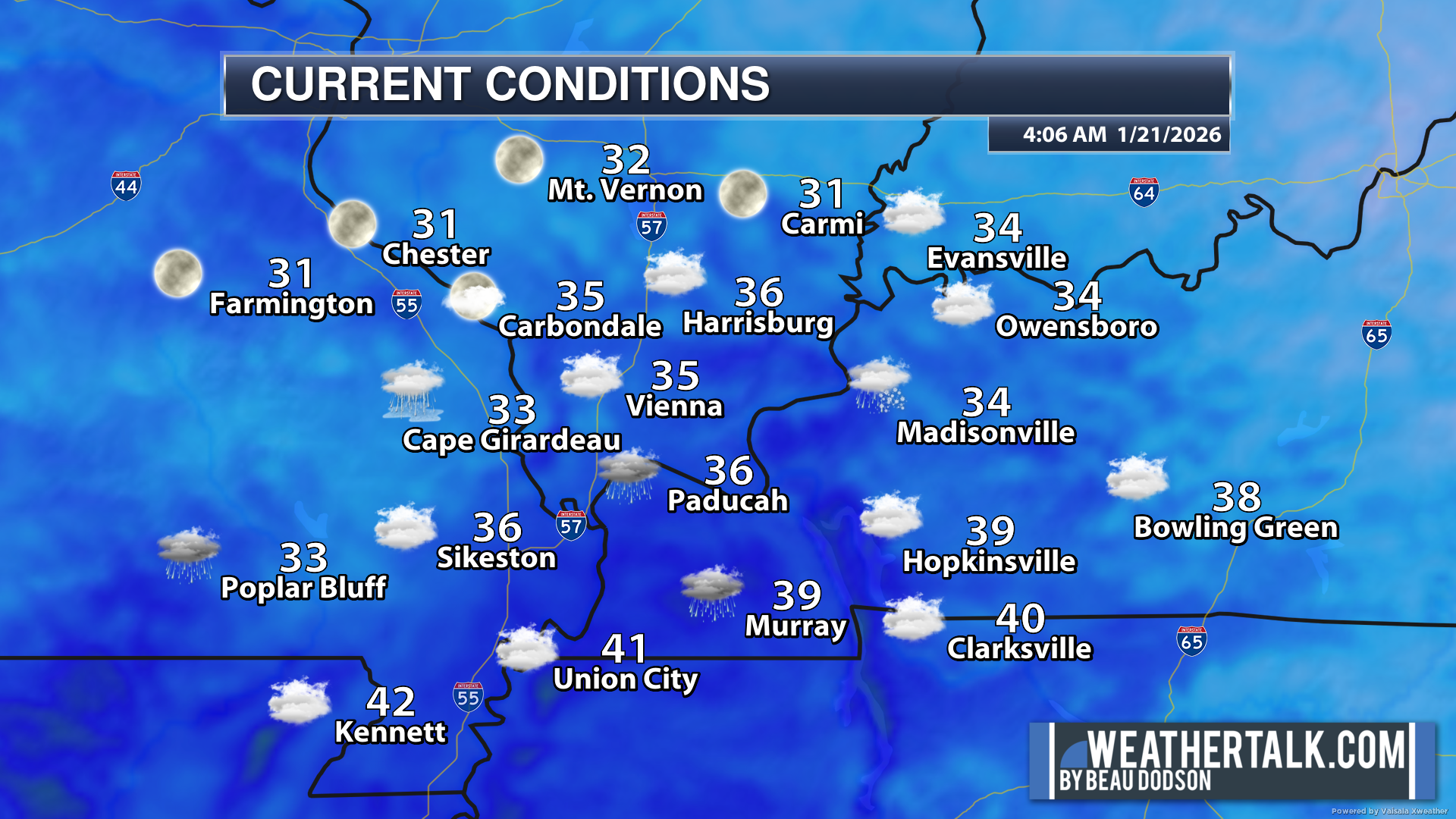
7. Is accumulating snow (one inch or more of snow) or ice in the forecast? YES. Some wintry mix early this morning. Temperatures will be rising.
Watch your first step this morning. Some icy surfaces are possible.
A small winter weather advisory has been issued for a few counties.
Temperatures are above freezing, but pavement temperatures will take a little more time to rise.
Watch for icy surfaces even outside the winter weather advisory.
The advisory will last until mid-morning.
Temperatures will rise into the forties today.
.
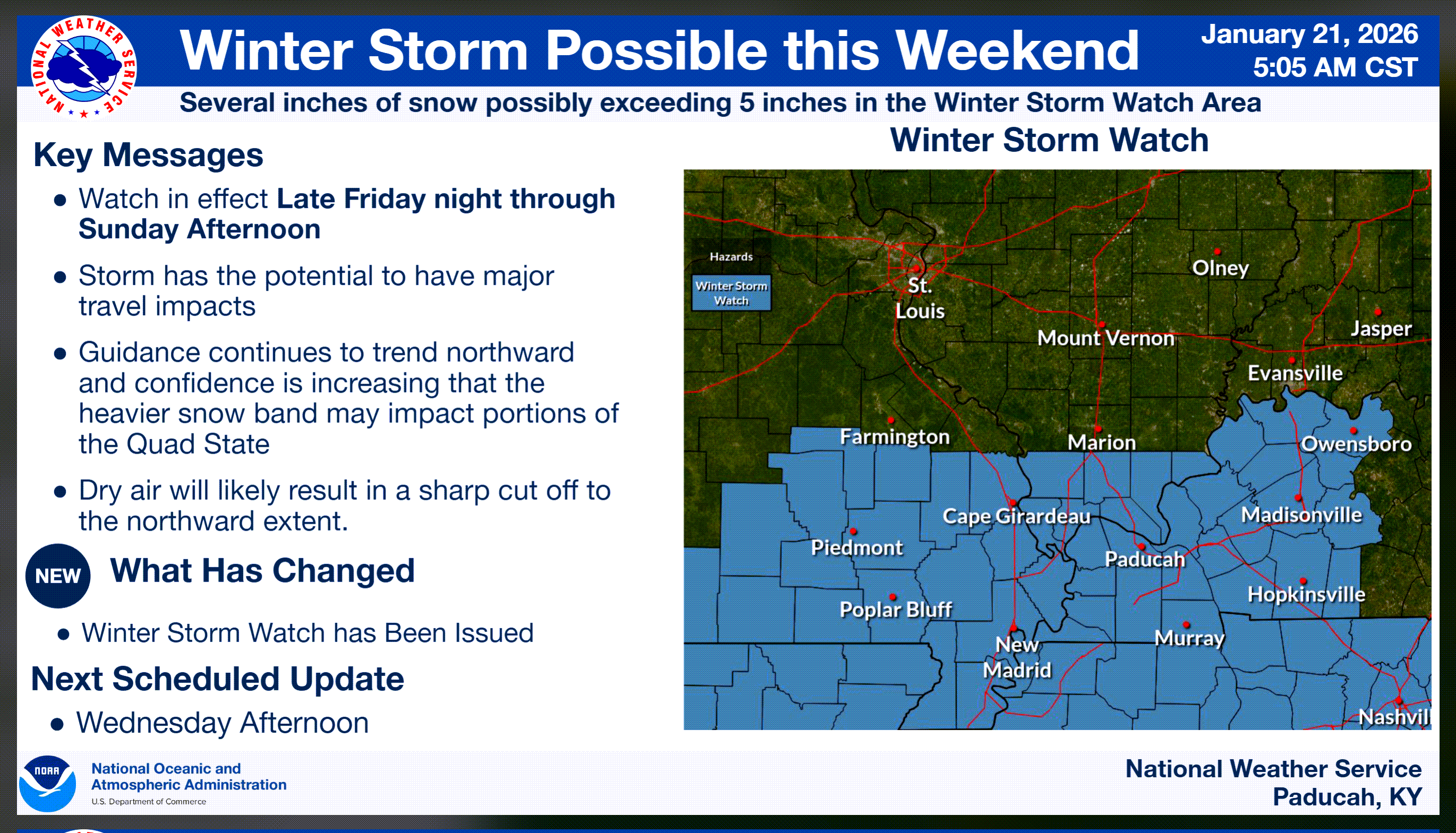
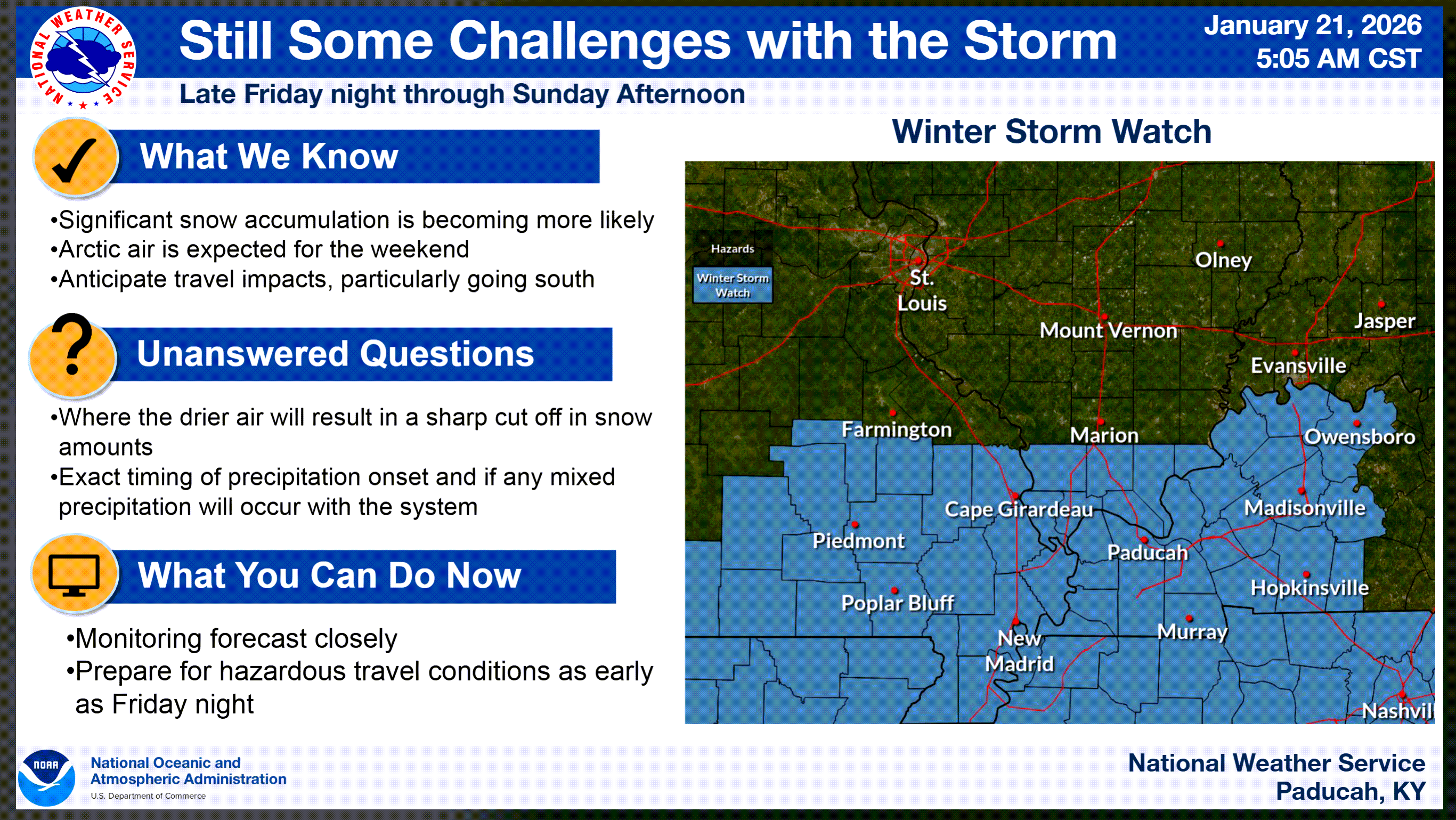
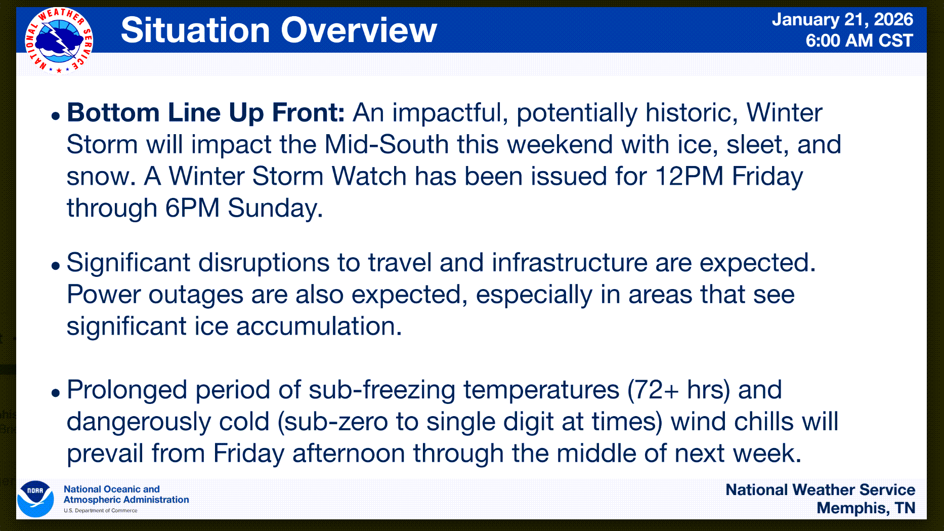
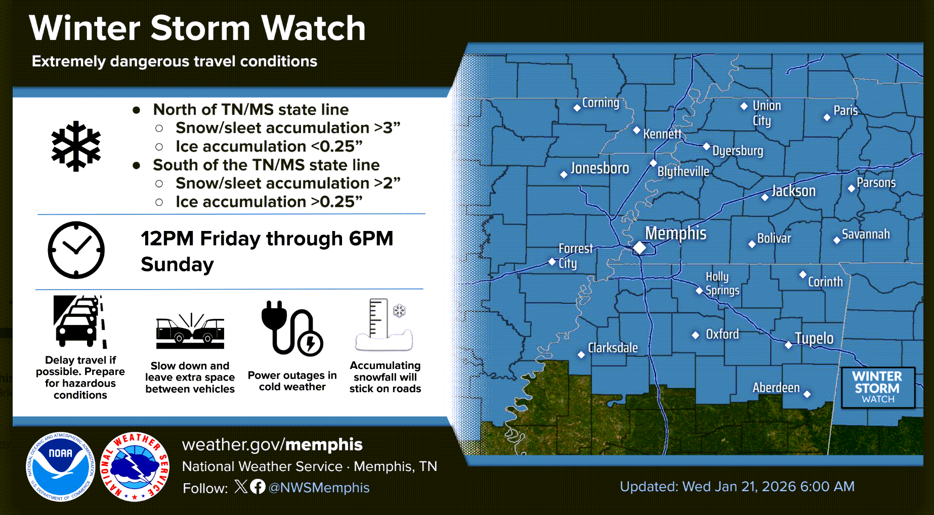
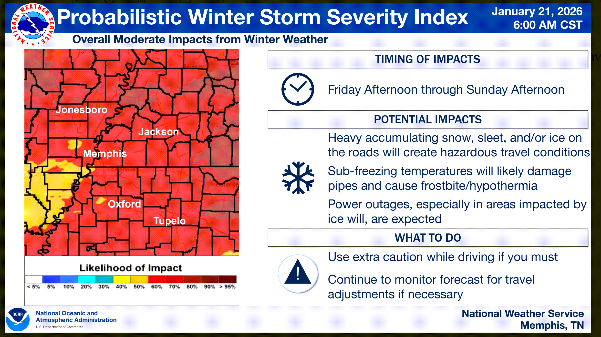
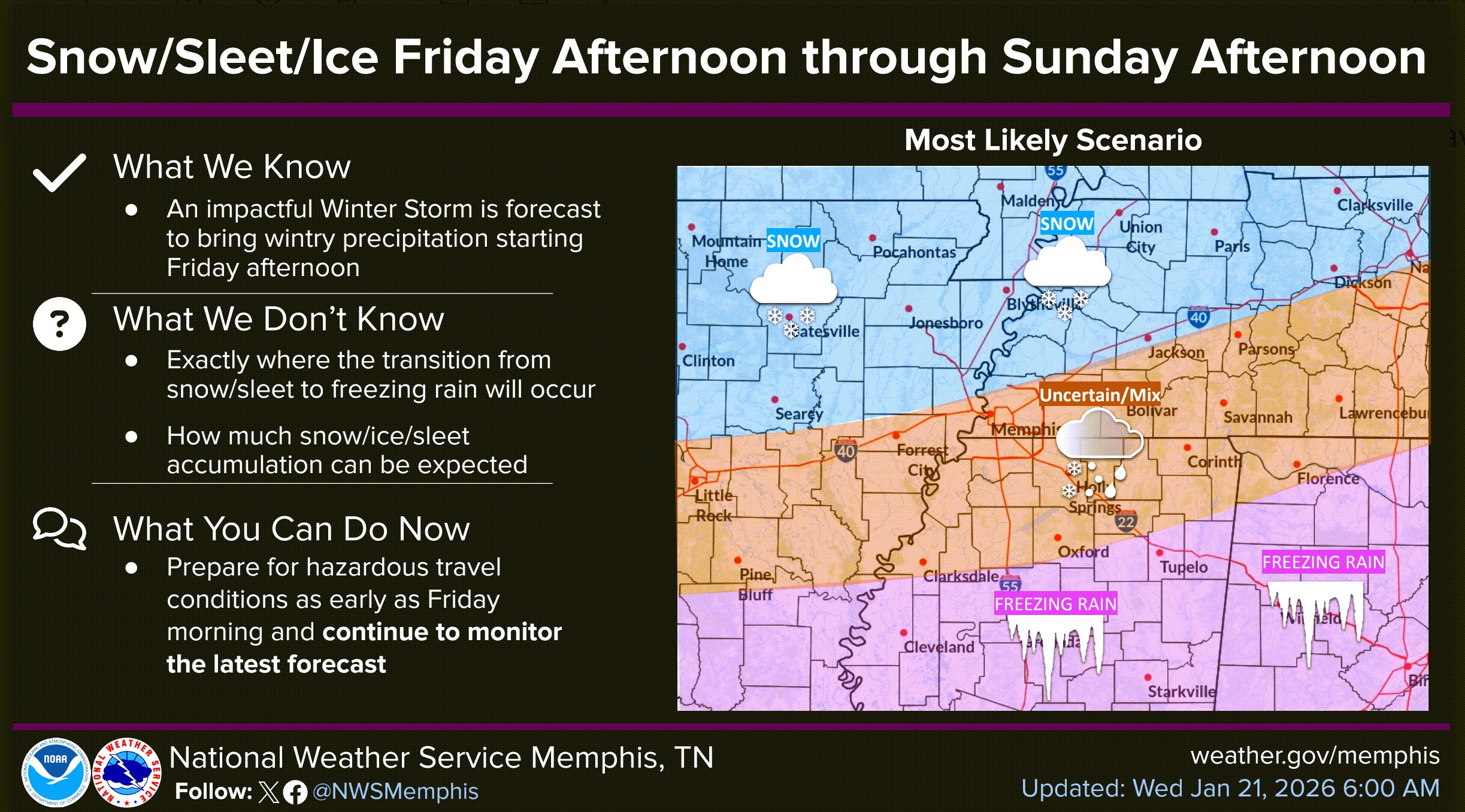
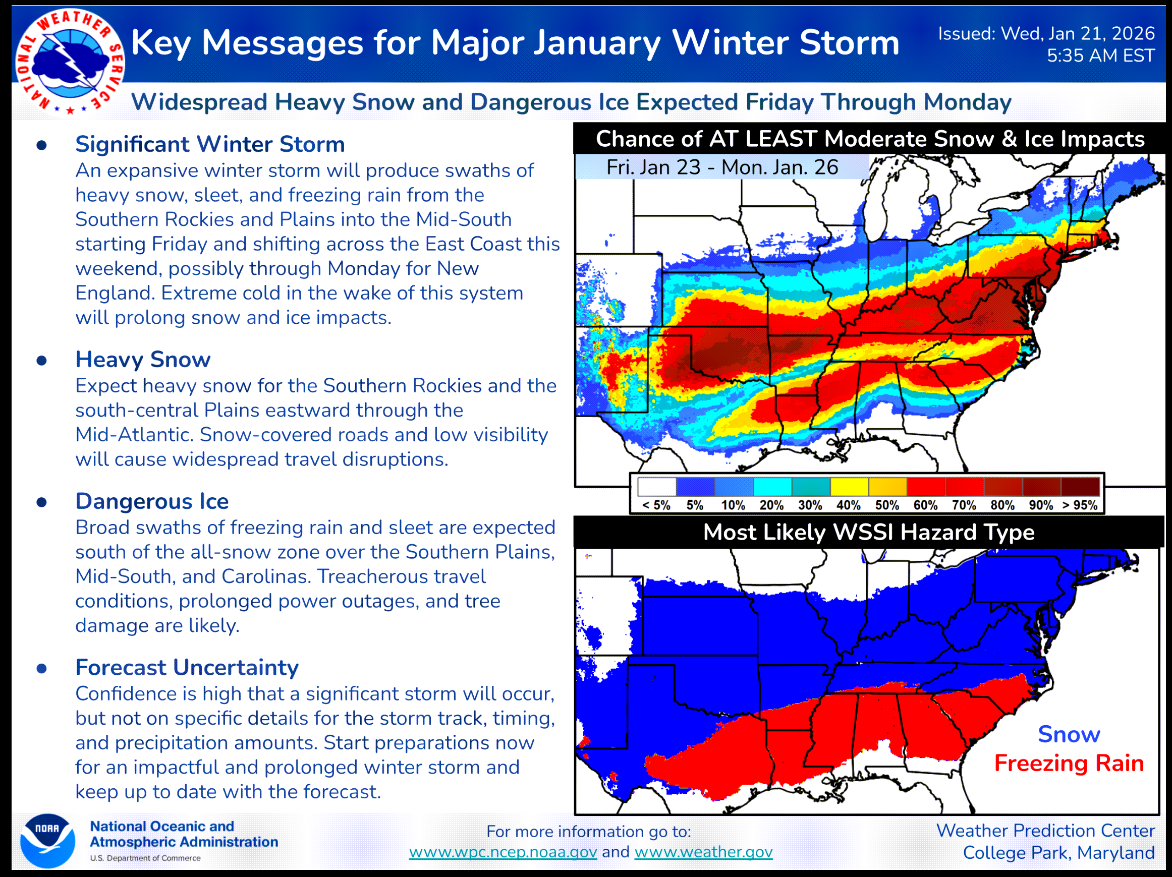
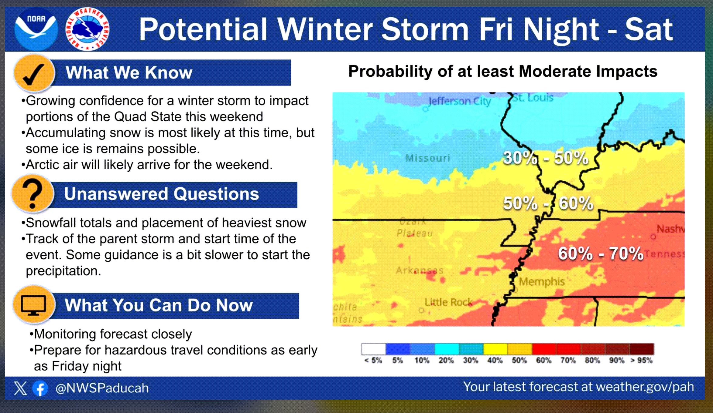
A winter storm could impact portions of the region on Friday night into Sunday. You will want to monitor updated forecasts. Confidence is rising that snow will impact our region.
There could be a sharp cutoff on the northern side of this winter storm. Those areas will receive little or no snow. Where to draw that line remains a question.
Updated graphics from the Paducah, Kentucky, NWS
The NWS could expand the winter storm watch northward. We need to see more data before that happens.
If the northward trend continues, then more counties would need to be under a winter storm watch.
.
Here are some graphics from the Memphis, TN, NWS. The Bootheel and northwest Tennessee.
.
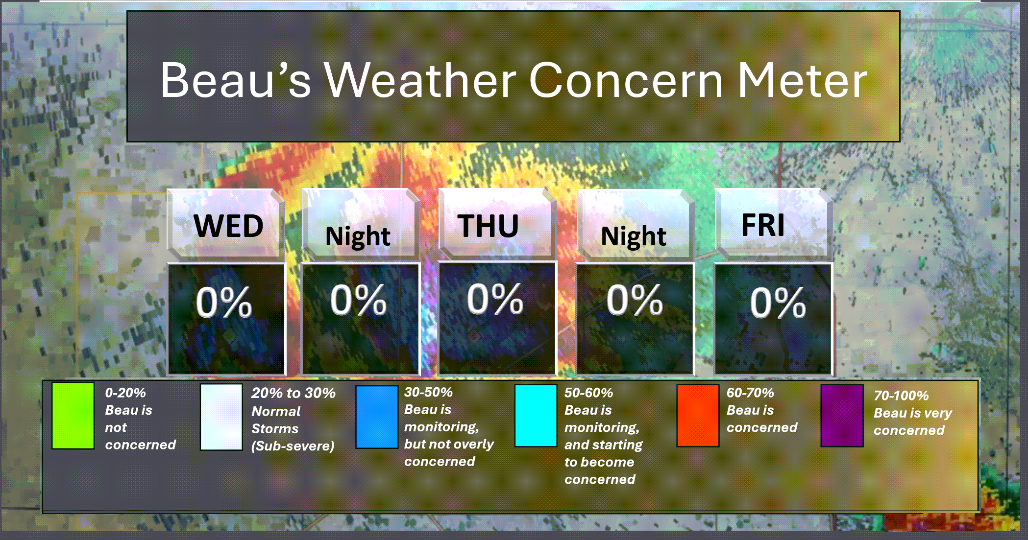
⛈️ Here is the short-range thunderstorm concern meter.
.
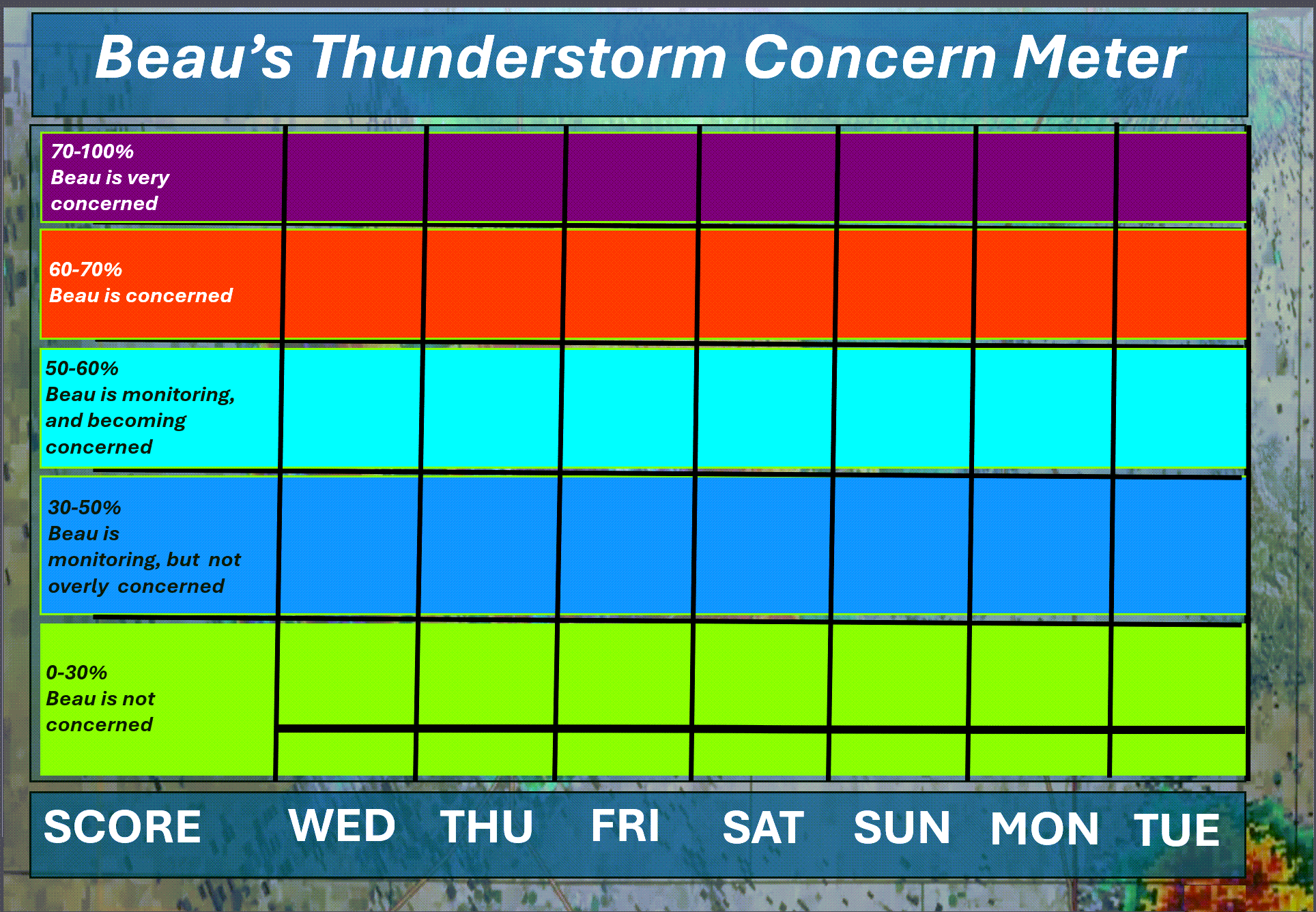
⛈️ Here is the extended thunderstorm concern meter.
We will remain in the green. No thunderstorm threats.
.


.
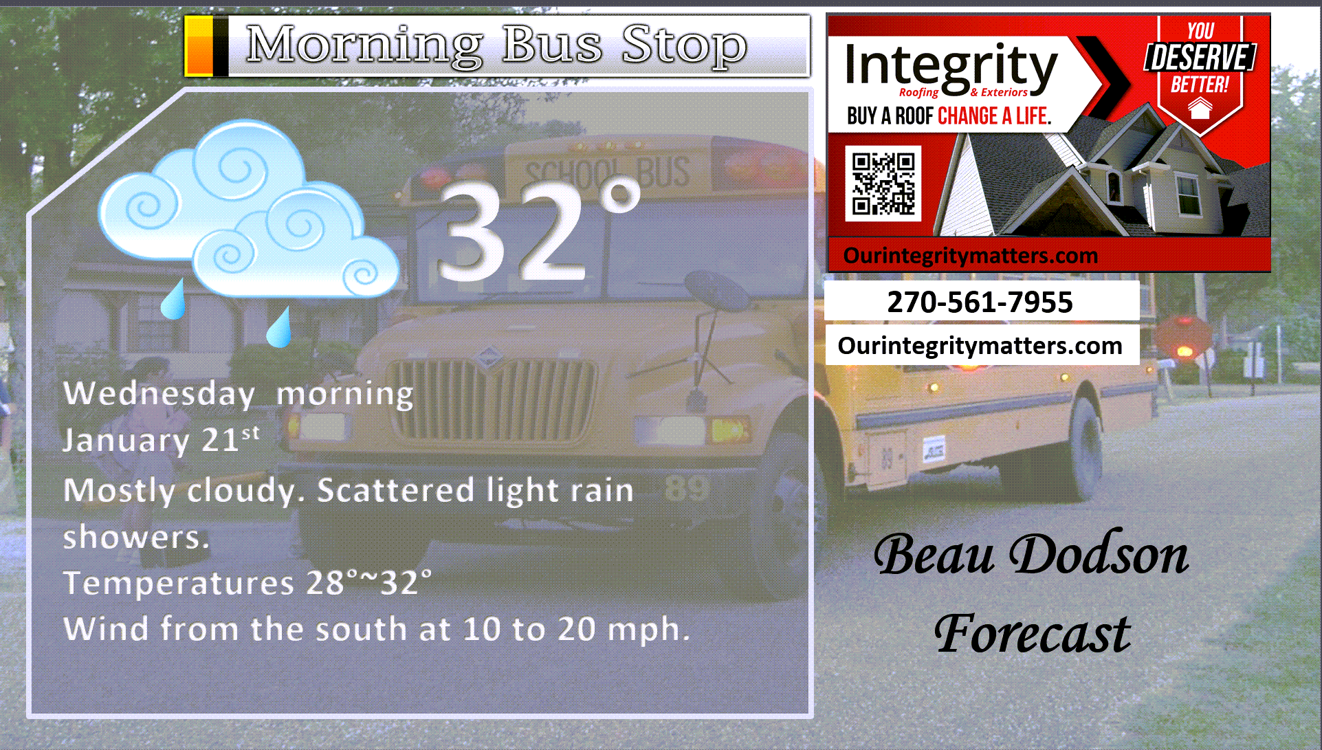
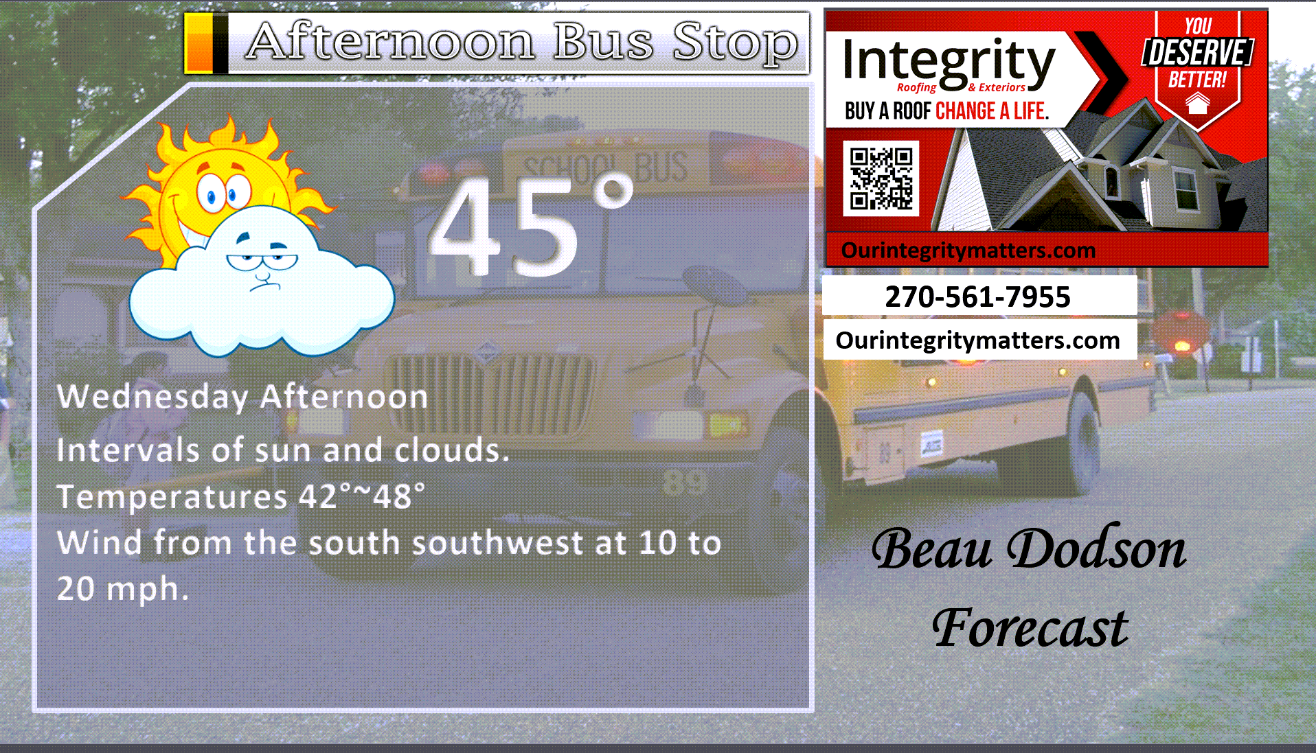
Here is your bus stop forecast
.
This afternoon
.

.

Forecast discussion
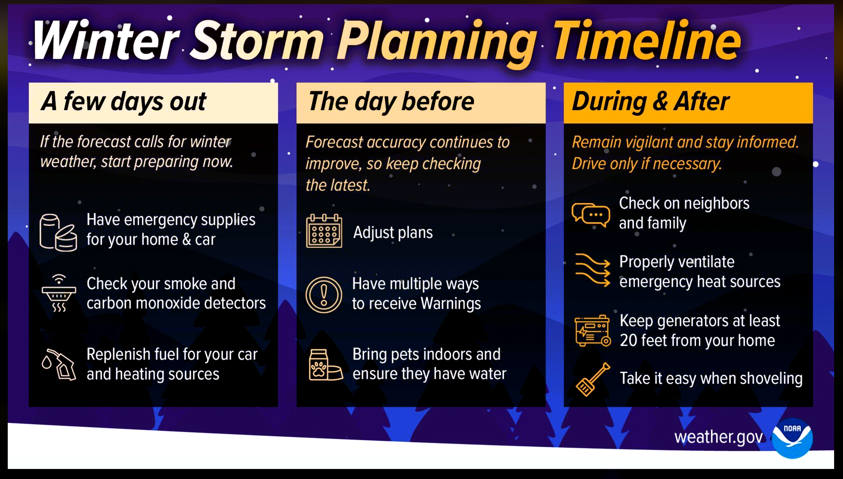
- Some light rain is possible today. Temperatures will be rising. Any light freezing rain or sleet will change to rain. Use caution early this morning.
- Some counties could have a glaze of ice this morning. Use care.
- I am tracking a winter storm that is forecast to arrive Friday night, Saturday, and Sunday. Confidence in an event is increasing.
- I have posted graphics below concerning the weekend event.
.
 .
.
.
What is the primary weather concern?
Here is today’s Facebook Q&A thread
The primary concern will be a weekend precipitation event and bitterly cold air. Likely the coldest air of the season.
.
.
Seven-day outlook graphic.
See the video or graphics below for more details specific to your county. This is a broad-brush overview of the entire region.
Notice the cold air this weekend. Brrr.
.
Today through Thursday night
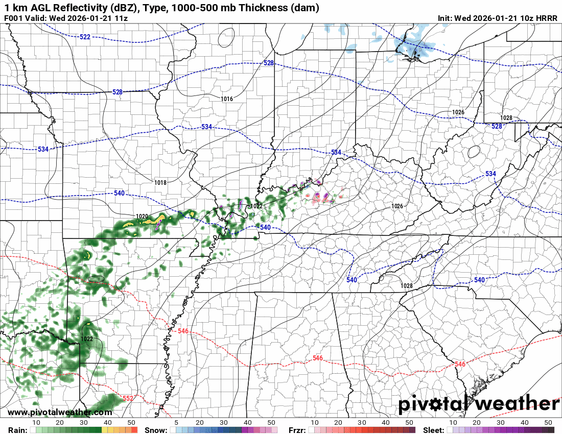
Temperatures are rising this morning on southerly winds.
There is some light rain around this morning. That will push eastward as we move through the day.
There are reports of icy road conditions in some areas. Use care early this morning.
You can see that on the Hrrr model.
The timestamp (upper left) is in Zulu. 12z=6 am. 18z=12 pm. 00z=6 pm.
Double-click the animation to enlarge it.
Green is rain. Yellow is moderate rain. Orange and red indicate locally heavy rain.
Blue is snow.
.
No weather concerns Wednesday night, Thursday, or Thursday night. I can’t rule out some flurries on Thursday night.
Colder air will be moving into the region on Friday. A bitterly cold weekend ahead of us.
.
Friday through Tuesday
** For planning purposes, if you have travel plans this weekend into early next week, then you will want to monitor updated forecasts. Significant travel impacts are possible in some of my counties. **
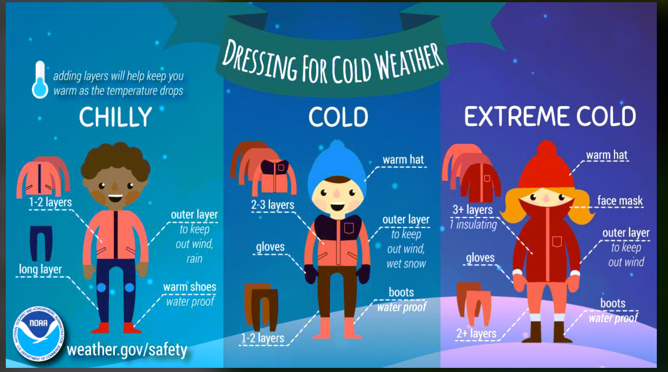
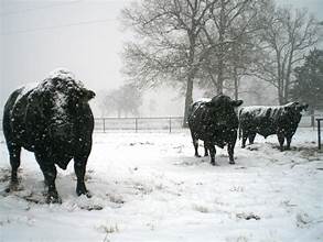
This event will be harsh on livestock and outdoor pets, as well. Especially if we have wind and snow (moisture).
.
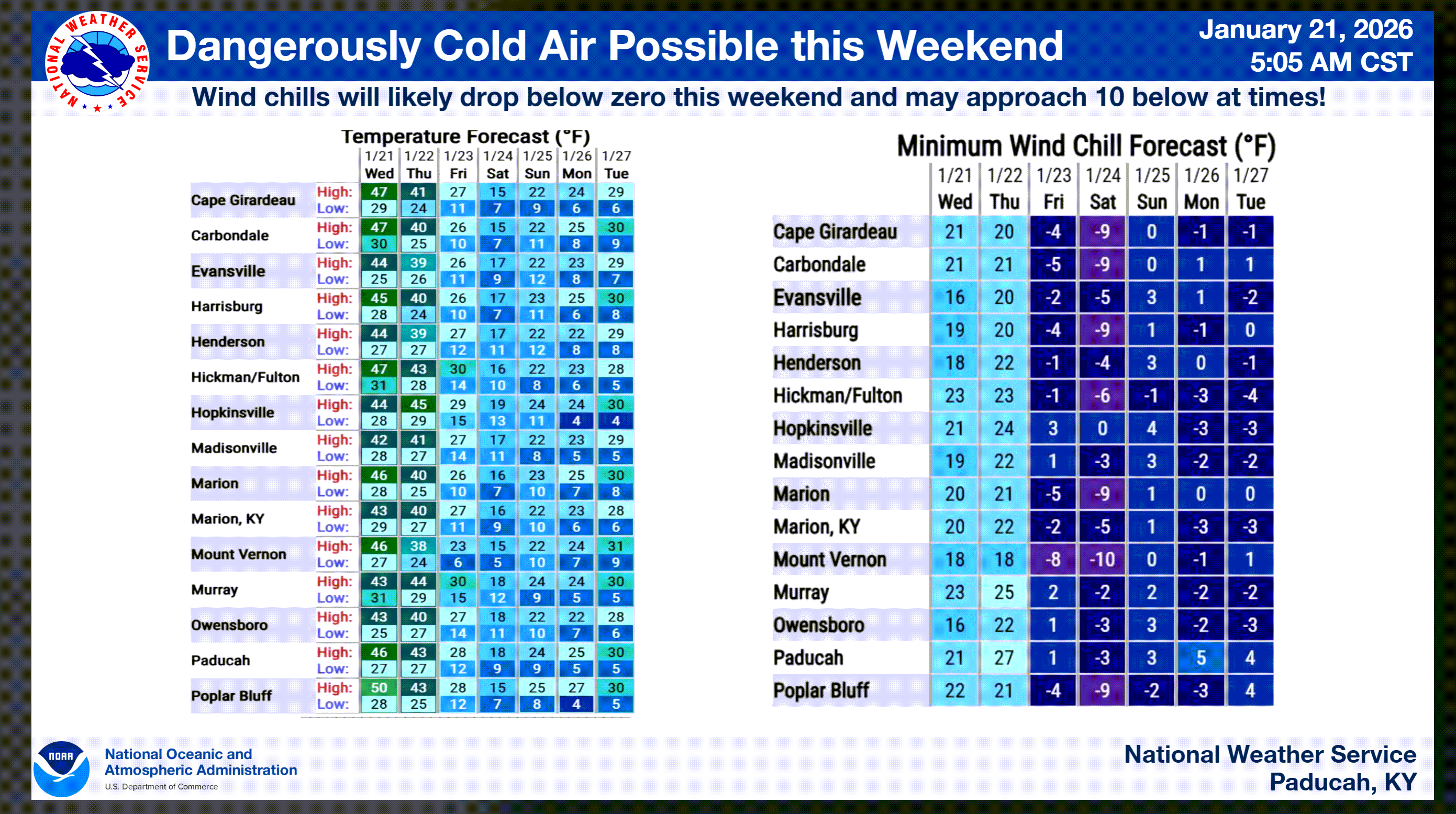
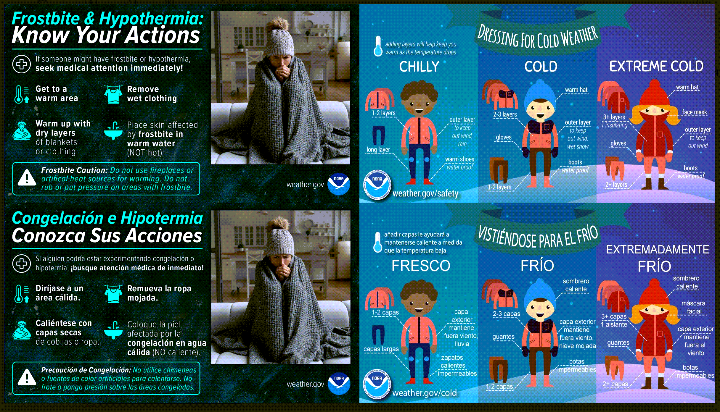
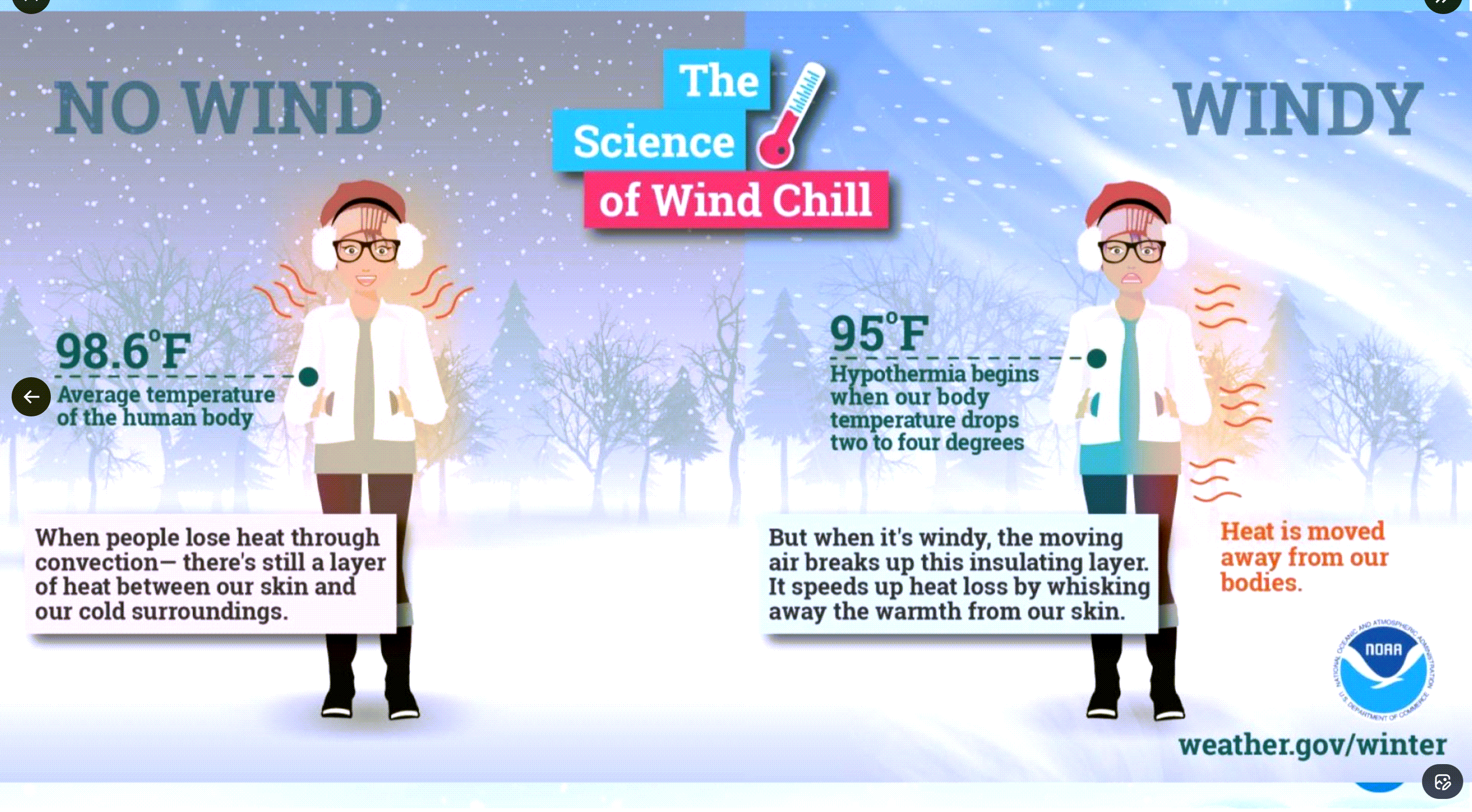
Wind chills will be an issue this weekend into early next week. At times, wind chill values could dip below -10 degrees.
Remember, wind chill is what it feels like to the human body.
Wind chill can lead to frostbite. Bundle up.
Let me show you the wind chill values
.
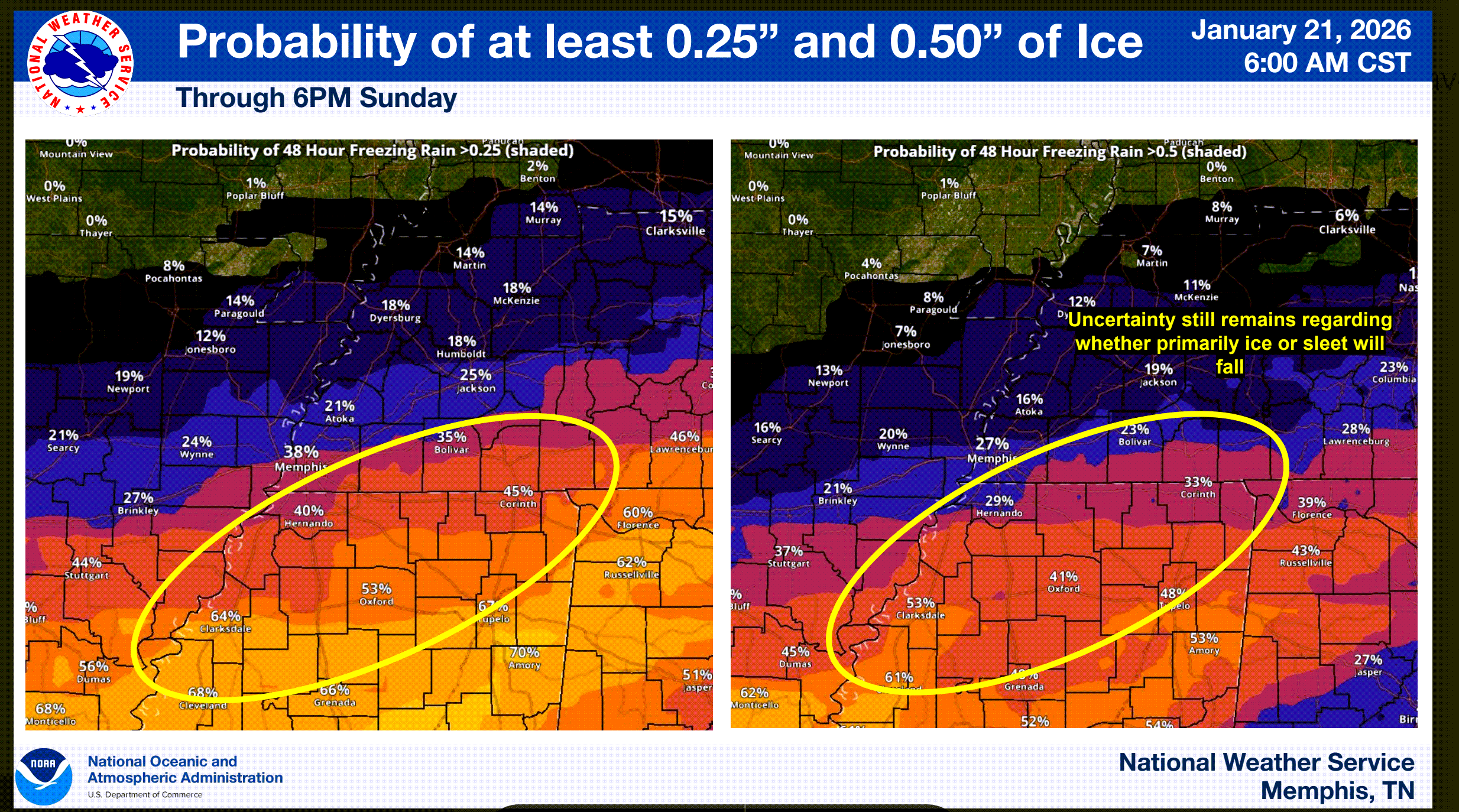
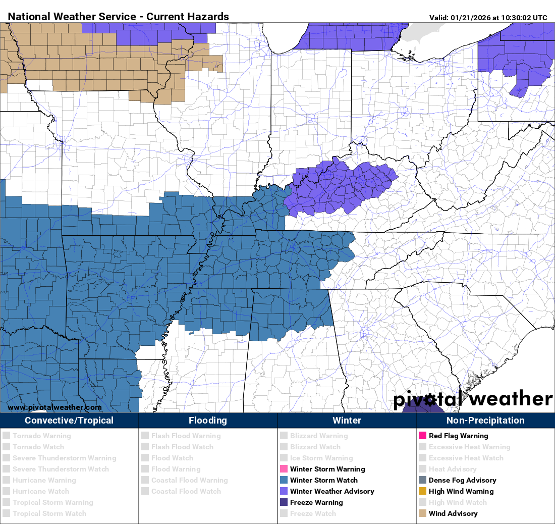
The National Weather Service has issued winter storm watches in blue. They could expand this northward. For now, they held off because we are not sure where the dry air will eat away at snow totals.
Monitor updated forecasts if you are not in the watch.
.
I know everyone is watching people post model graphics online. Hard not to see them.
Remember, all models are wrong. Some are just more wrong than others.
Try to not focus on every model run. Try not to focus on one model run. They will all vary in how they depict this winter storm.
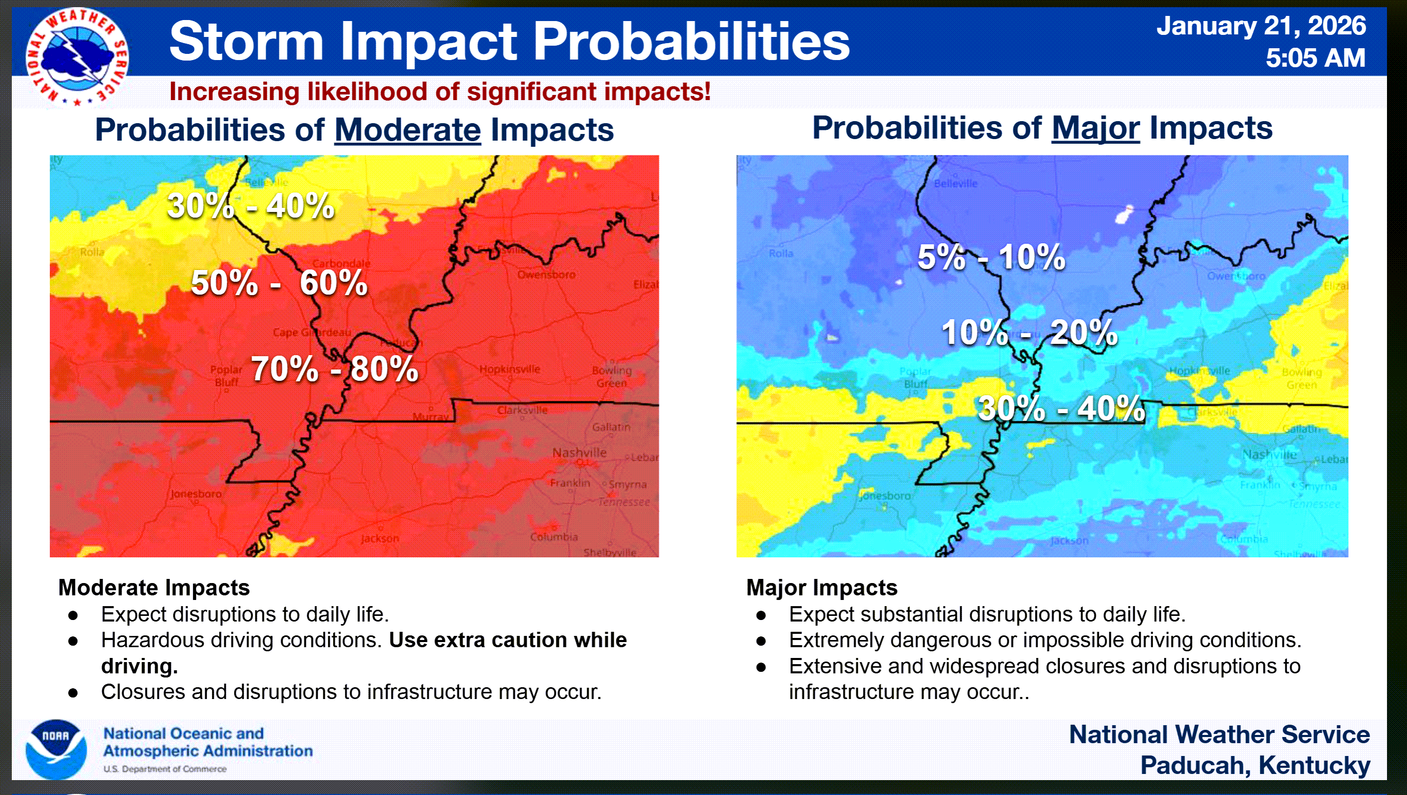
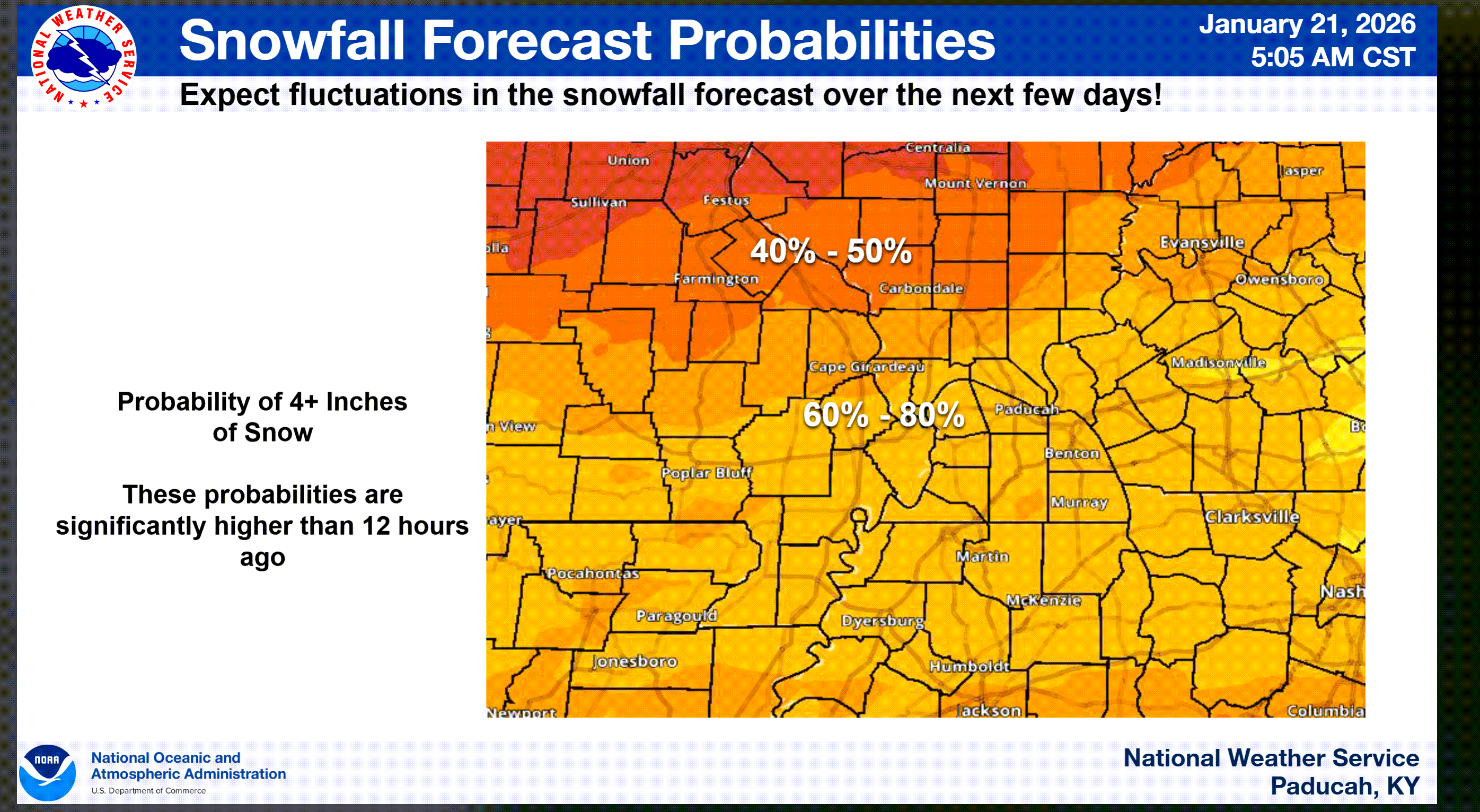
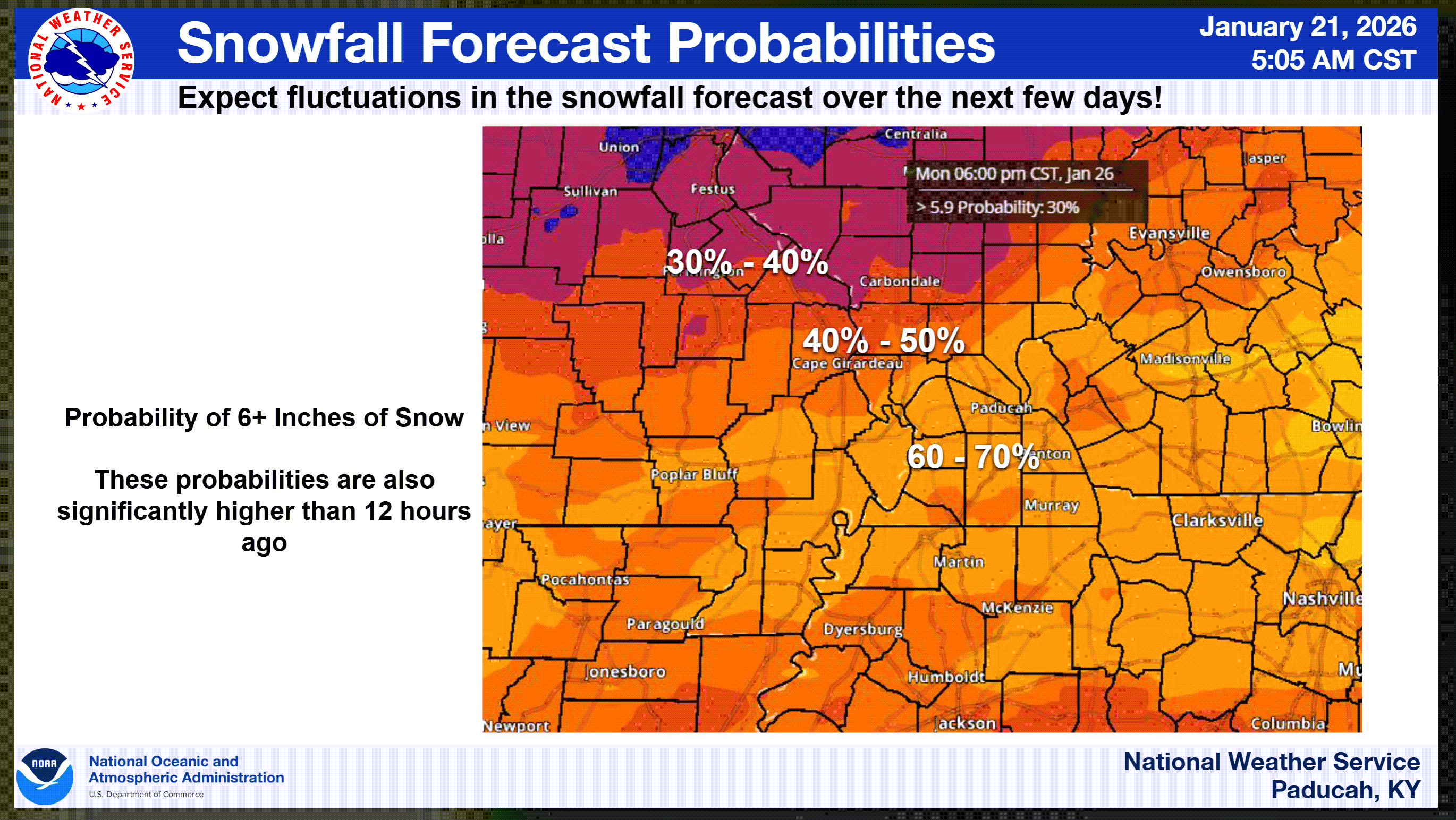
Confidence in snow Friday night through Sunday is now 60% to 80%. Those numbers have increased from the previous update.
.
What we don’t know are the exact totals for every county and city.
Keep in mind that my northern counties may receive less snow. This is highly dependent on the storm track. Any shift north or south will change your local county forecast.
We aren’t confident about where to draw the cutoff between quite a bit of snow and not much snow. The sharp gradient in snow totals. Accumulation will likely be less north and more south.
A shift of 25 miles will make a big difference in snow totals.
This system is still out over the Pacific Ocean. We are threading a needle with our snow forecasts.
The bulk of the snow will fall late Friday night. More likely, it will arrive Saturday morning and linger into Sunday. There could be a brief lull on Saturday before more snow arrives. Keep that in mind, as well.
What falls will accumulate. It will be cold.
Snow ratios will be high with this event. The bitterly cold air will mean snow ratios of 15:1 or greater.
There are some questions about the wind speed several thousand feet above us. If it is too strong, then it will rip the snowflakes apart. That would lower the ratios just a tad.
What are snow ratios?
Typically, 0.10″ of precipitation (melted) equals one inch of snow.
With this system, 0.10″ of melted liquid precipitation could be 1.5 to 2.5″ of snow. It does not take much precipitation to create a decent snow event.
There will also likely be a sharp cutoff in snow totals from north to south. As mentioned above.
Radar may show snow falling, but it could be virga. Virga is precipitation that falls from the clouds but does not reach the ground. It is evaporating.
This is normal with bitterly cold temperatures. It is rarely too cold for snow, but it can impact how the storm acts.
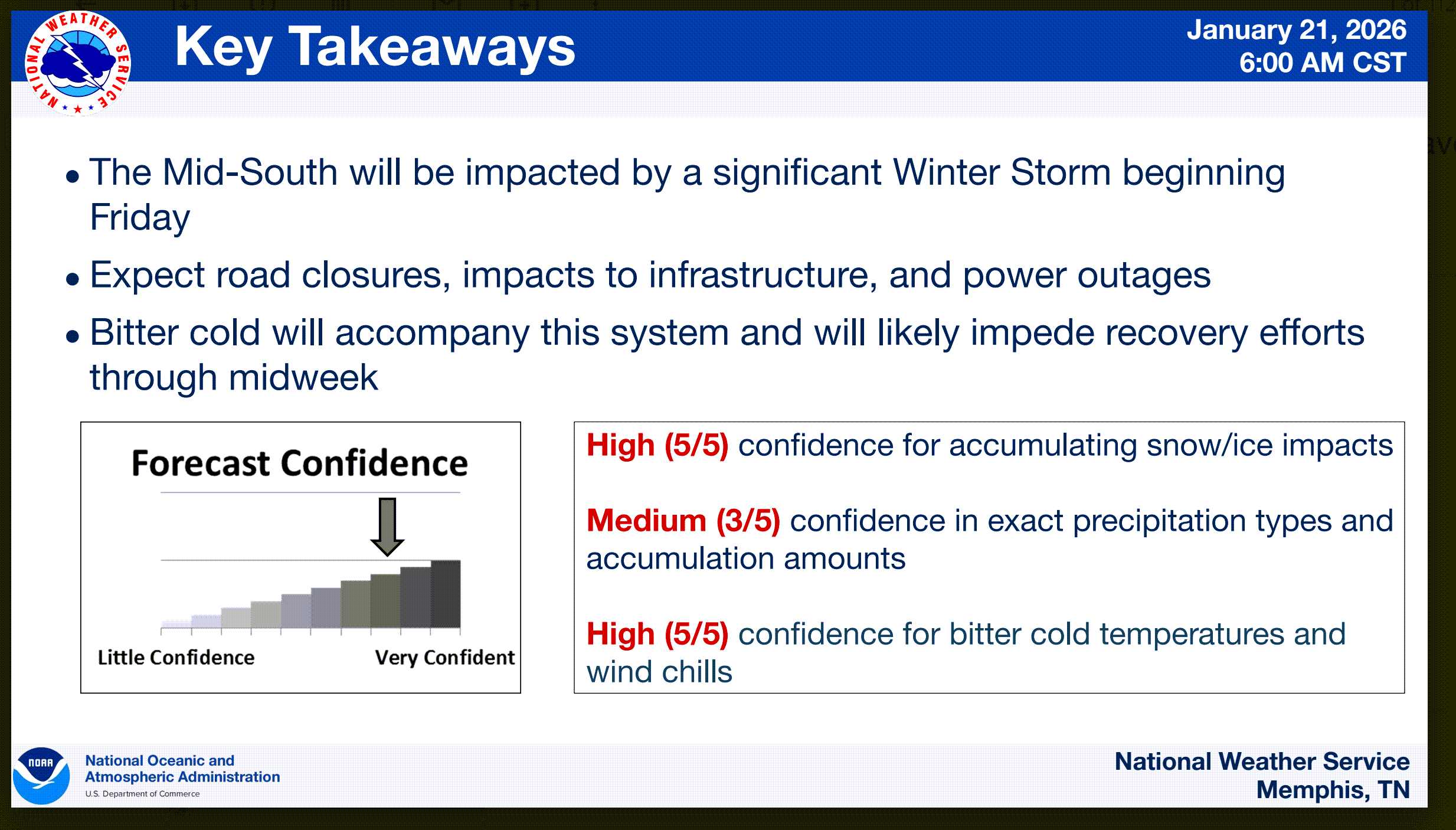
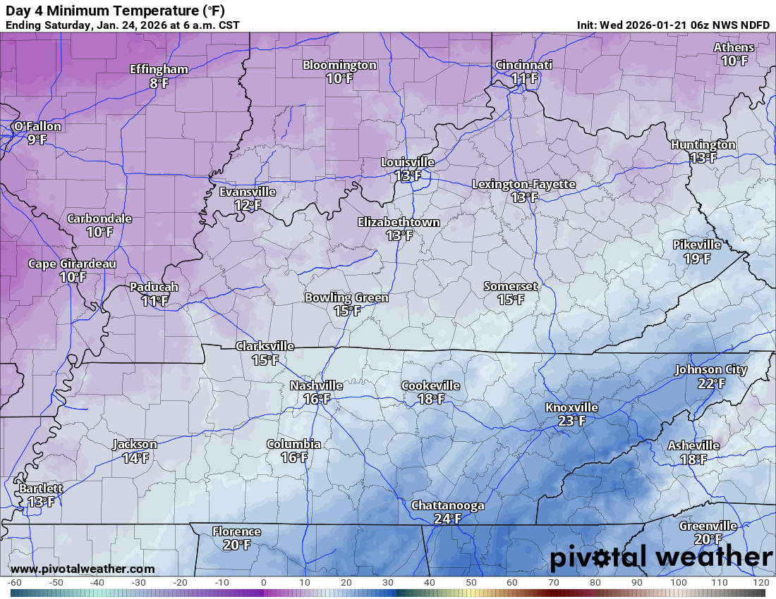
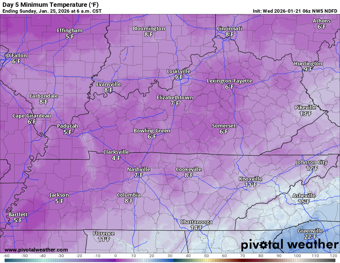
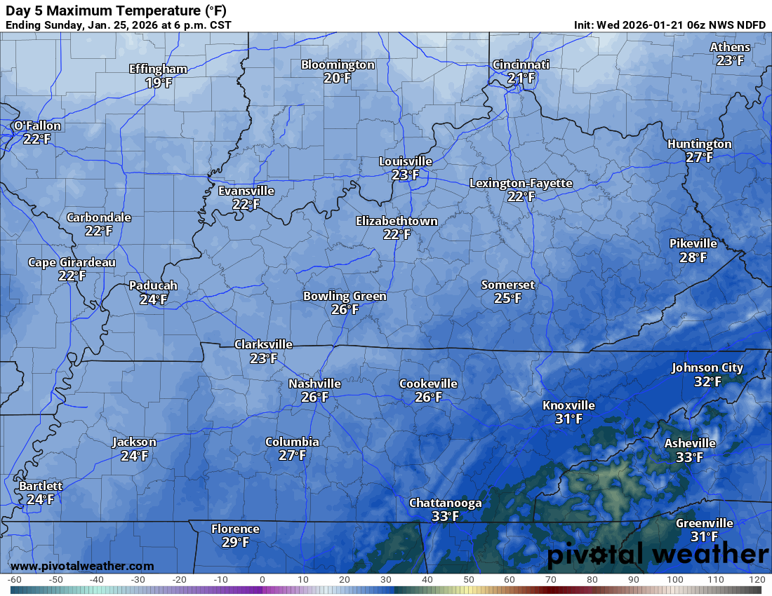
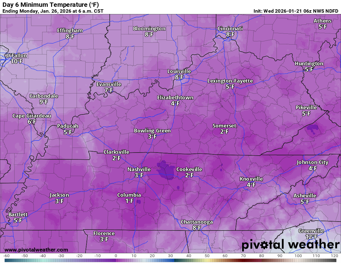
High Confidence (5/5) that very cold air will be in place across the region Friday night into next Tuesday.
That means Friday night, Saturday night, and Sunday night will likely be in the single digits to lower teens. Even colder if we have snow on the ground.
Medium Confidence (3/5) in precise storm track and precipitation amounts.
Yesterday, that number was (2/5). It has gone up a bit.
It appears that the risk of sleet and freezing rain will remain to our south. I will be monitoring this.
Some of the overnight data brought the sleet zone into the Bootheel and along the Kentucky/Tennessee border southward.
I mentioned that as a possibility yesterday.
We are now within three to four days of the event.
There is high confidence that a winter storm will impact portions of the Ohio or Tennessee Valley. The question is where and how much?
The majority of guidance indicates that snow will affect our region from late Friday night through Sunday.
If you have travel plans, then you may need to adjust them.
Again, let’s not forget that this is a bitterly cold air-mass.
Single digits are possible this coming weekend. Brrr.
If we end up with snow on the ground, then Saturday night and Sunday night will be even colder.
That means temperatures below zero into the single digits. Wind chill values of -15 to 5 above. Double brrr.
Let me show you some more graphics.
These graphics may vary between NWS offices. Keep that in mind.
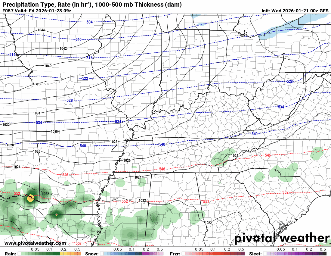
Let’s look at some raw model data.
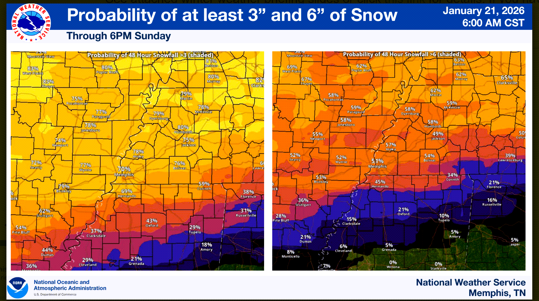
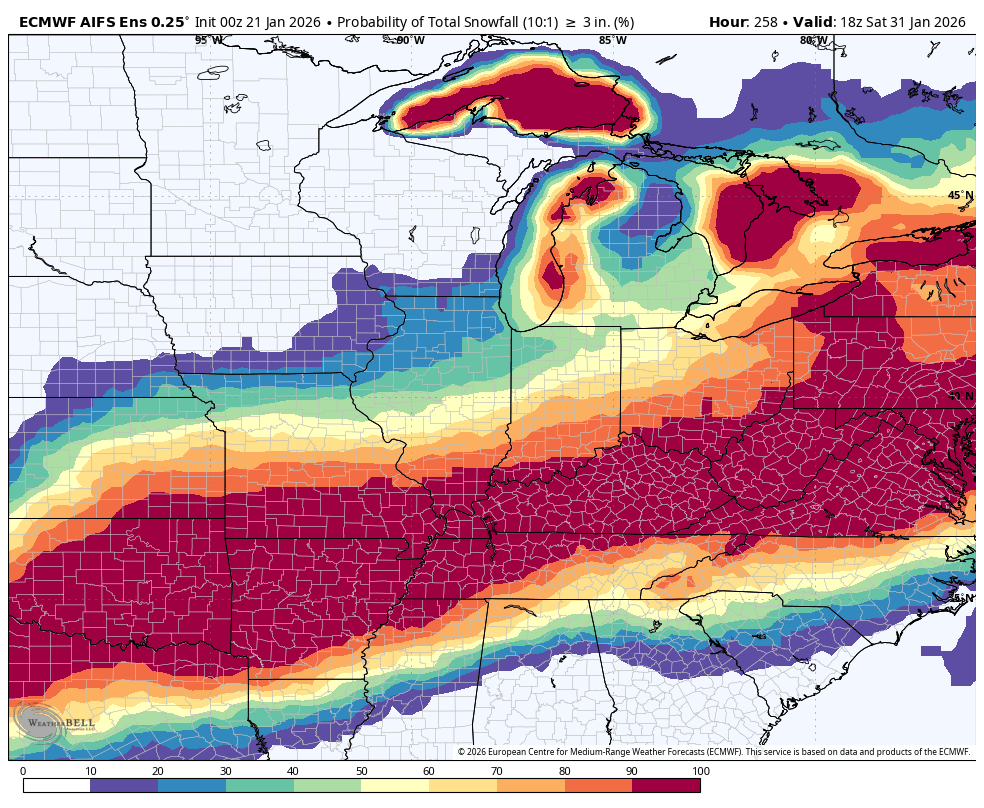
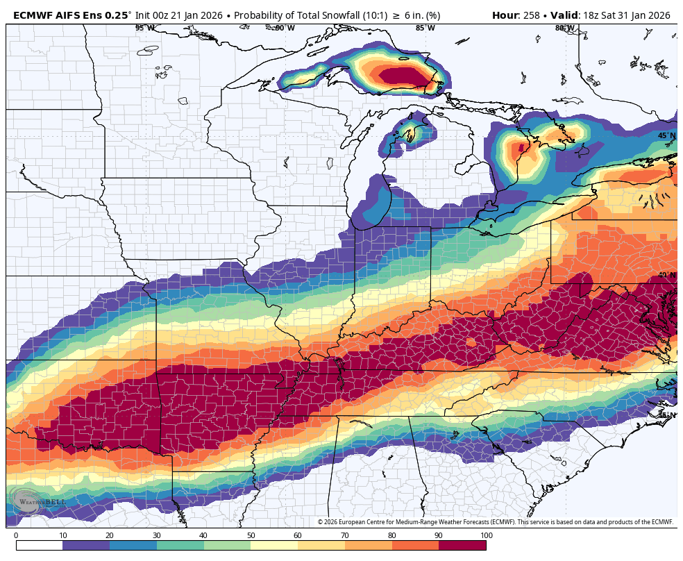
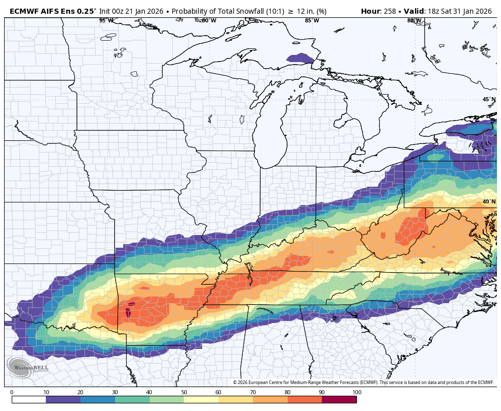
Here is the EC AI model. It usually scores the highest in accuracy.
These numbers are with 10:1 snow ratios. We expect ratios to be even higher. Thus, these numbers are actually a little low.
Keep in mind, ANY shift in the storm track will change these probabilities.
These are some pretty big numbers. I will be monitoring trends.
What is the chance of three or more inches of snow?
What is the chance of six or more inches of snow?
Let’s look ahead to the next cold shot. It will arrive on Friday night.
.
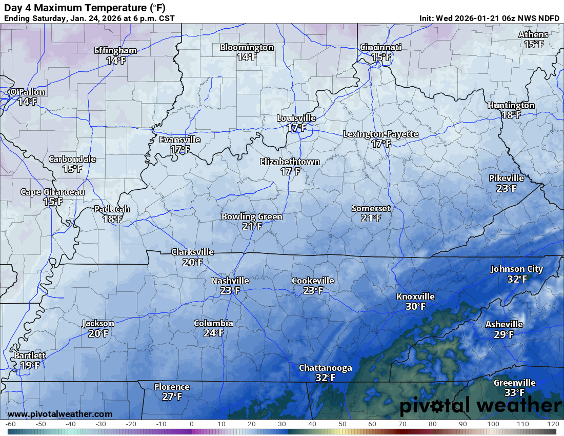
Sunday high temperatures. If we have snow on the ground, then it could be even colder than shown.
.
.

The timestamp (upper left) is in Zulu. 12z=6 am. 18z=12 pm. 00z=6 pm.
Double-click the animation to enlarge it.
Green is rain. Yellow is moderate rain. Orange and red indicate locally heavy rain.
Blue is snow.
EC model
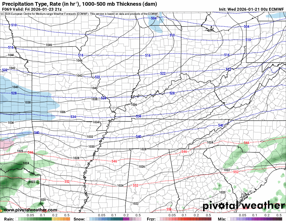
.
The timestamp (upper left) is in Zulu. 12z=6 am. 18z=12 pm. 00z=6 pm.
Double-click the animation to enlarge it.
Green is rain. Yellow is moderate rain. Orange and red indicate locally heavy rain.
Blue is snow.
GFS model
.
..
.
Click here if you would like to return to the top of the page.
.Average high temperatures for this time of the year are around 44 degrees.
Average low temperatures for this time of the year are around 27 degrees.
Average precipitation during this time period ranges from 1.00″ to 1.25″
Six to Ten Day Outlook.
Blue is below average. Red is above average. The no color zone represents equal chances.
Average highs for this time of the year are in the lower 60s. Average lows for this time of the year are in the lower 40s.

Green is above average precipitation. Yellow and brown favors below average precipitation. Average precipitation for this time of the year is around one inch per week.

.

Average low temperatures for this time of the year are around 26 degrees.
Average precipitation during this time period ranges from 1.00″ to 1.25″
.
Eight to Fourteen Day Outlook.
Blue is below average. Red is above average. The no color zone represents equal chances.

Green is above average precipitation. Yellow and brown favors below average precipitation. Average precipitation for this time of the year is around one inch per week.

.
.
.
We have a new service to complement your www.weathertalk.com subscription. This does NOTreplace www.weathertalk.com It is simply another tool for you to receive severe weather information.
.
https://weathercallservices.com/beau-dodson-weather


Want to receive the daily forecast/other products on your Beau Dodson Weather app?
Did you know you have four options in your www.weathertalk.com account
You will then receive these via your Beau Dodson Weather app.
Just log into your www.weathertalk.com account
Click the NOTIFICATION SETTINGS TAB
Then, turn them on (green) and off (red)
🌪️ Number 1 is the most important one. Severe alerts, tornado alerts, and so on.
Number 2 is the daily video, blog, livestream alerts, and severe weather Facebook threads on severe days or winter storm days.
Number 3 is the daily forecast. I send that out every day during the afternoon hours. It is the seven-day forecast, hazardous weather outlook, fire outlook, and more.
Number 4 is to receive the daily video, blog, and other content on NON-severe weather days (every day without severe threats in other words)
GREEN IS ON
RED IS OFF

I am going to start going live during bigger severe weather events.
Check it out here https://www.youtube.com/user/beaudodson
Click the subscribe button (it’s a free subscription button), and it will alert you when I go live. I will also send out alerts to the app when I go live for an event.

.

Radars and Lightning Data
Interactive-city-view radars. Clickable watches and warnings.
https://wtalk.co/B3XHASFZ
Old legacy radar site (some of you like it better)
https://weatherobservatory.com/weather-radar.htm
If the radar is not updating then try another one. If a radar does not appear to be refreshing then hit Ctrl F5. You may also try restarting your browser.
Backup radar site in case the above one is not working.
https://weathertalk.com/morani
Regional Radar
https://imagery.weathertalk.com/prx/RadarLoop.mp4
** NEW ** Zoom radar with chaser tracking abilities!
ZoomRadar
If the radar is not working, then email me: Email me at beaudodson@usawx.com
.
We do have some sponsors! Check them out.
Roof damage from recent storms? Link – Click here
INTEGRITY ROOFING AND EXTERIORS!
⛈️ Roof or gutter damage from recent storms? Today’s weather is sponsored by Integrity Roofing. Check out their website at this link https://www.ourintegritymatters.com/

![]()
![]()
![]()
Make sure you have three to five ways of receiving your severe weather information.
Weather Talk is one of those ways! Now, I have another product for you and your family.

.
Want to add more products to your Beau Dodson Weather App?
Receive daily videos, weather blog updates on normal weather days and severe weather and winter storm days, your county by county weather forecast, and more!
Here is how to do add those additional products to your app notification settings!
Here is a video on how to update your Beau Dodson Weather payment.
The app is for subscribers. Subscribe at www.weathertalk.com/welcome then go to your app store and search for WeatherTalk
Subscribers, PLEASE USE THE APP. ATT and Verizon are not reliable during severe weather. They are delaying text messages.
The app is under WeatherTalk in the app store.

Apple users click here

Android users click here
.
Radars and Lightning Data
Interactive-city-view radars. Clickable watches and warnings.
https://wtalk.co/B3XHASFZ
Old legacy radar site (some of you like it better)
https://weatherobservatory.com/weather-radar.htm
If the radar is not updating then try another one. If a radar does not appear to be refreshing then hit Ctrl F5. You may also try restarting your browser.
Backup radar site in case the above one is not working.
https://weathertalk.com/morani
Regional Radar
https://imagery.weathertalk.com/prx/RadarLoop.mp4
** NEW ** Zoom radar with chaser tracking abilities!
ZoomRadar
Lightning Data (zoom in and out of your local area)
https://wtalk.co/WJ3SN5UZ
Not working? Email me at beaudodson@usawx.com
National map of weather watches and warnings. Click here.
Storm Prediction Center. Click here.
Weather Prediction Center. Click here.
.

Live lightning data: Click here.
Real time lightning data (another one) https://map.blitzortung.org/#5.02/37.95/-86.99
Our new Zoom radar with storm chases
.
.

Interactive GOES R satellite. Track clouds. Click here.
GOES 16 slider tool. Click here.
College of DuPage satellites. Click here
.

Here are the latest local river stage forecast numbers Click Here.
Here are the latest lake stage forecast numbers for Kentucky Lake and Lake Barkley Click Here.
.
.
Find Beau on Facebook! Click the banner.


 .
.