
Click one of the links below to take you directly to that section
Do you have any suggestions or comments? Email me at beaudodson@usawx.com
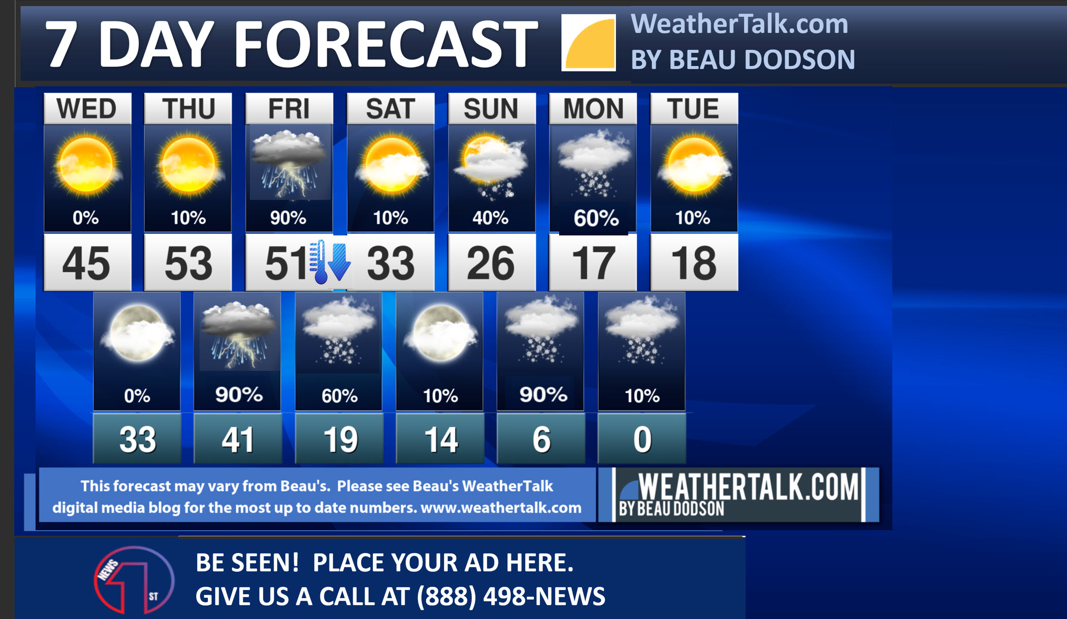
Seven-day forecast for southeast Missouri, southern Illinois, western Kentucky, and western Tennessee.
This is a BLEND for the region. Scroll down to see the region by region forecast.
THE FORECAST IS GOING TO VARY FROM LOCATION TO LOCATION. Scroll down to see the region by region forecast.
1. Prepare for bitterly cold air this weekend into next week. Multiple days below freezing. Some nights in the single digits and teens. Pipe busting weather.
2. Monitor updates concerning Friday’s storm track. The snow line could get close to my forecast counties. Snow showers possible elsewhere Friday night with rapidly falling temperatures. Flash freeze likely.
3. Monitor updates concerning a winter storm Sunday afternoon/night into Monday.

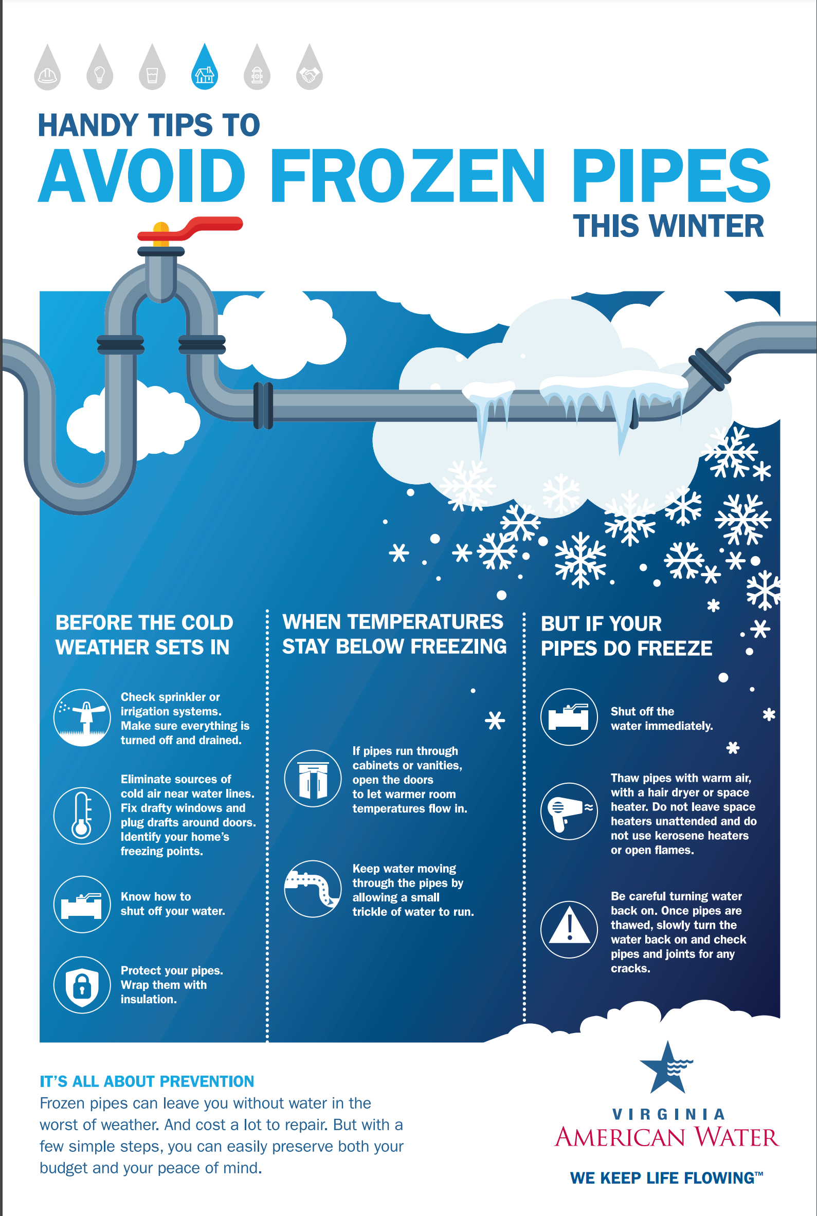
A frozen water pipe in winter, closeup, shallow depth of field. water tap covered with ice. ai generative.
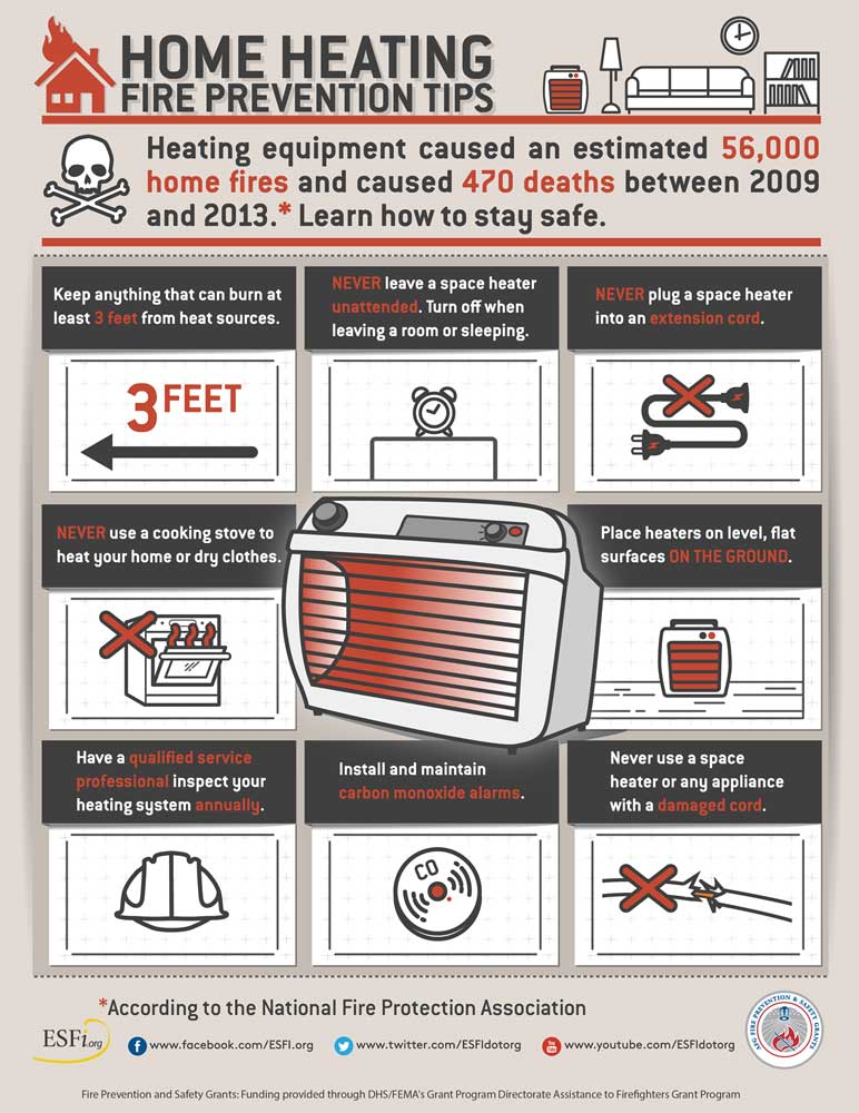
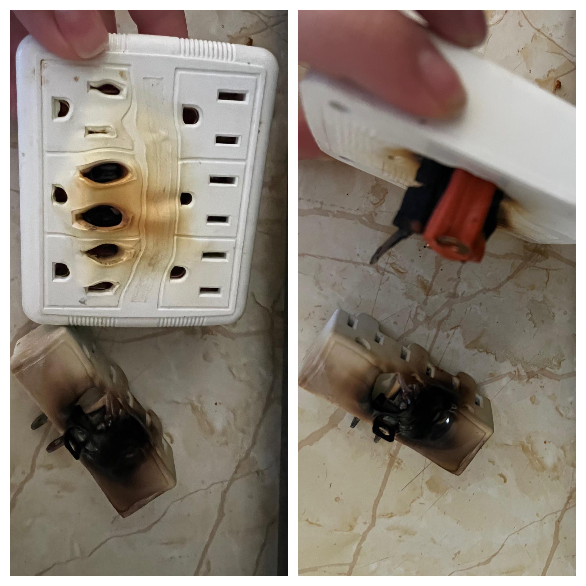
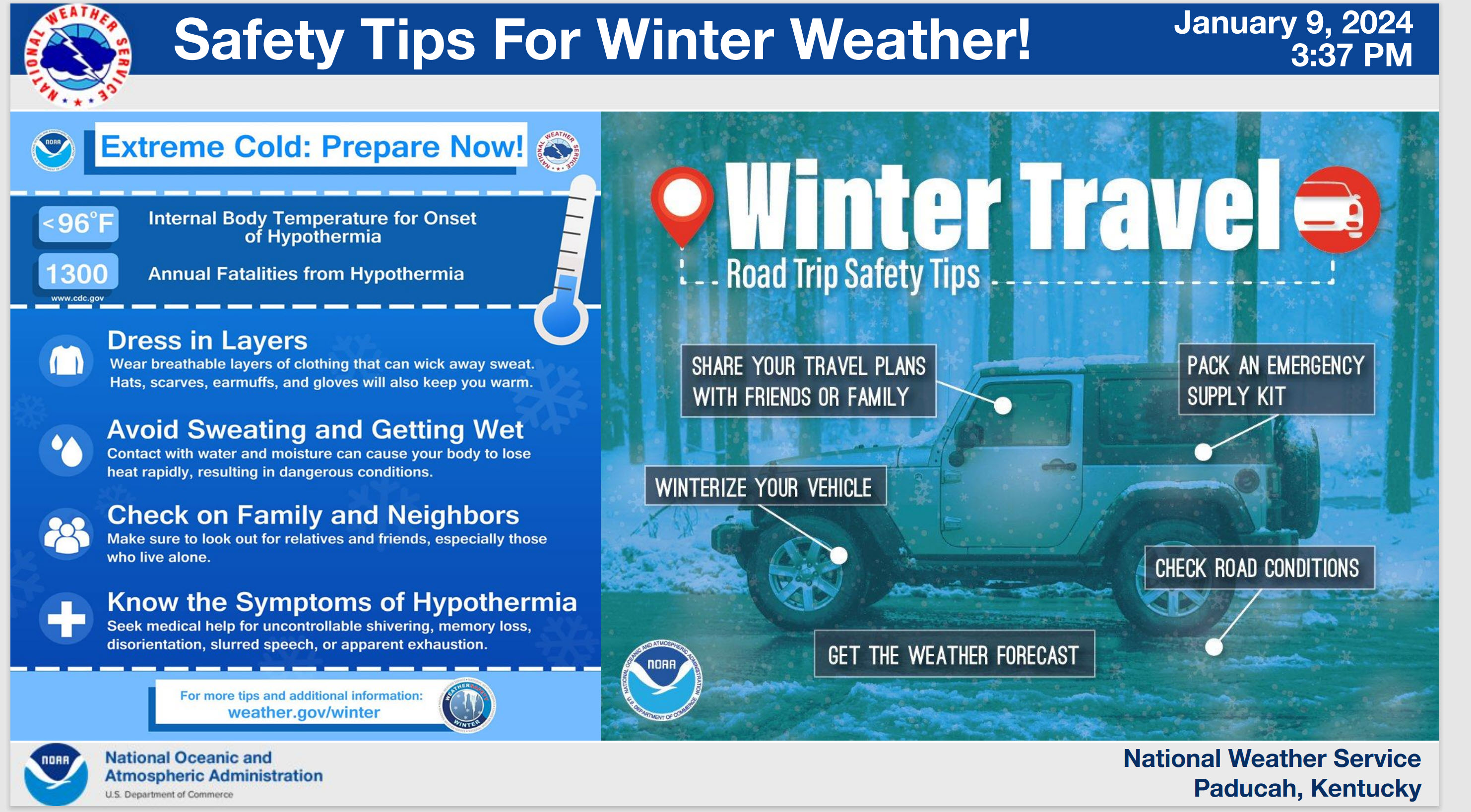
Avoid extension cords with space heaters. Every year our region experiences house fires because of this.
Double click image to view it better. Enlarge it.
More tips at this link click here
.
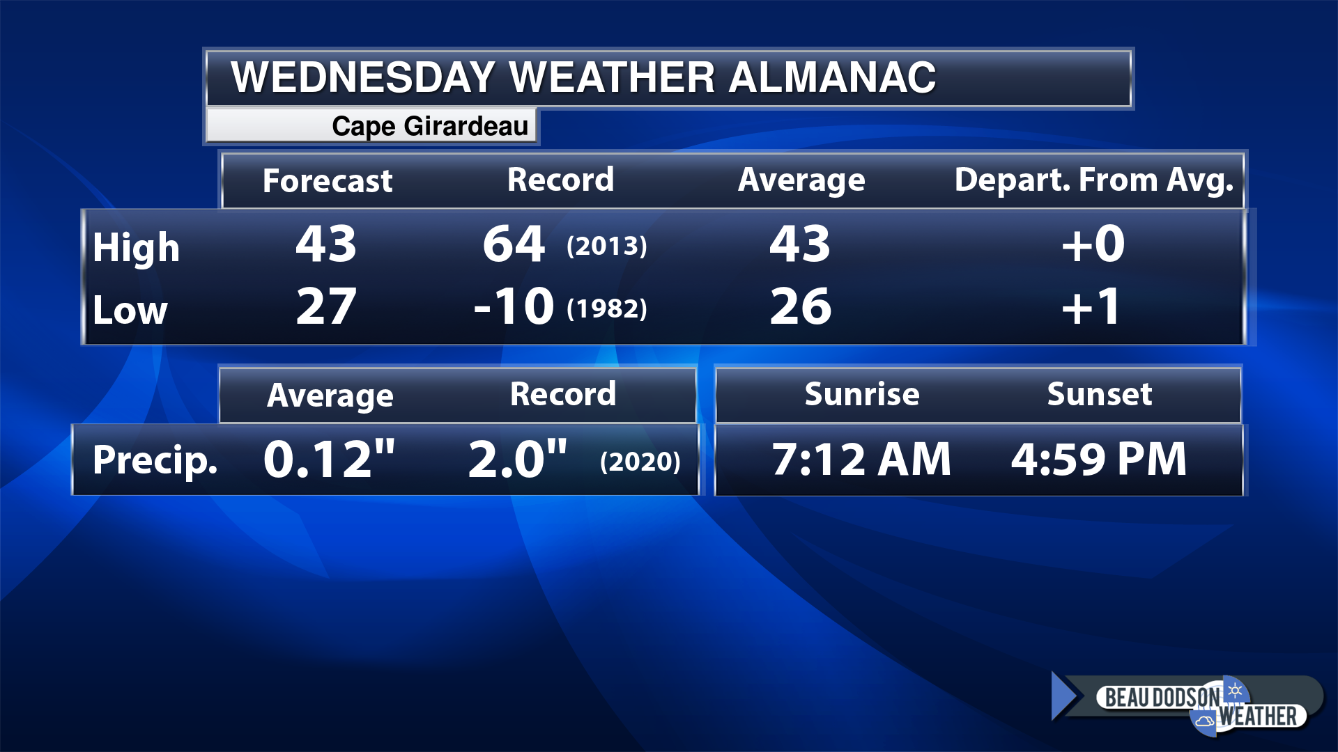
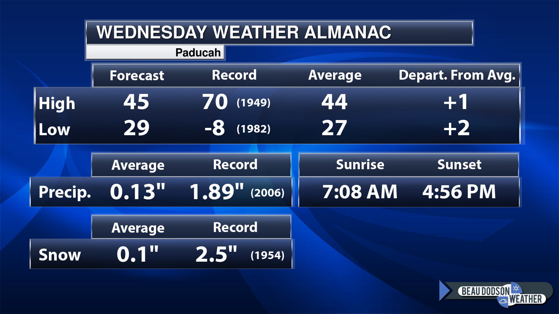
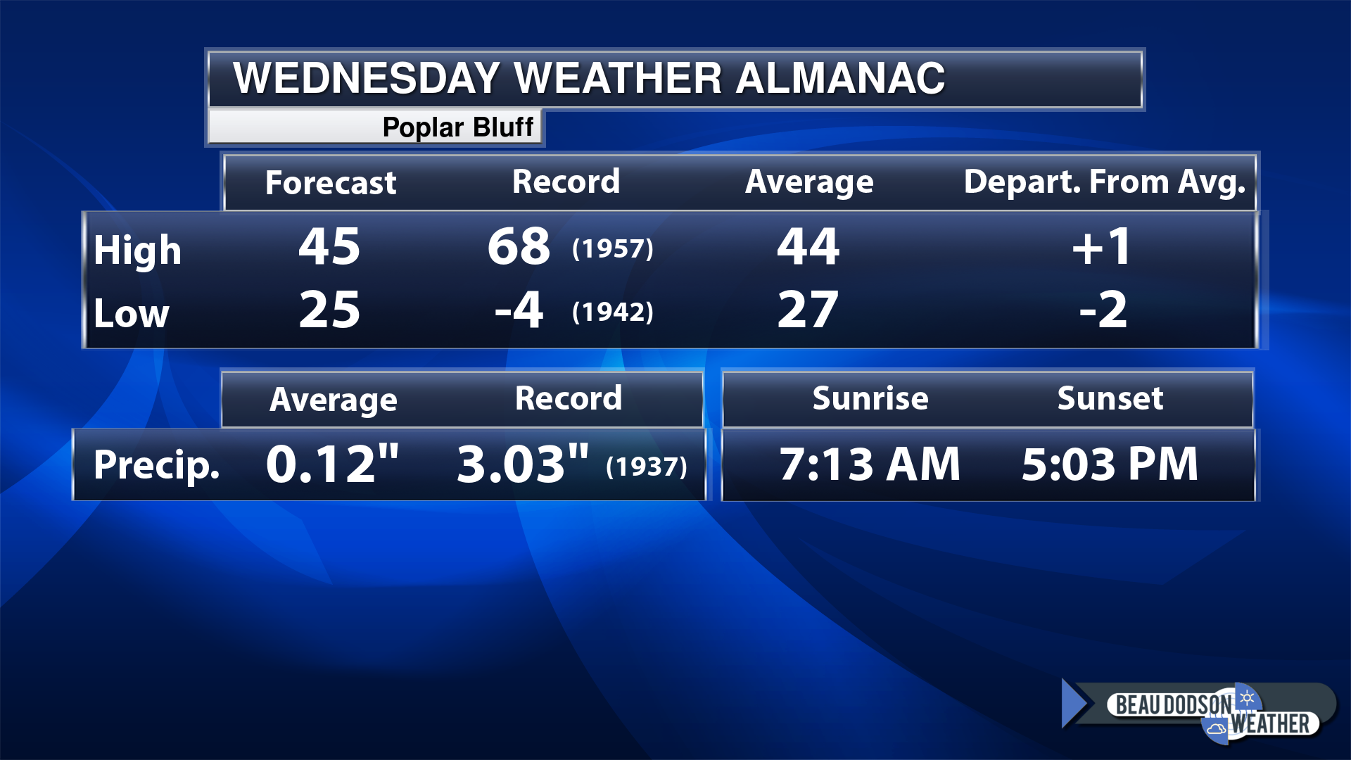
Today’s Local Almanacs (for a few select cities). Your location will be comparable.
Note, the low is this morning’s low and not tomorrows.
Today’s almanac numbers from a few select local cities.
The forecast temperature shows you today’s expected high and this morning’s low.
The graphic shows you the record high and record low for today. It shows you what year that occurred, as well.
It then shows you what today’s average temperature is.
Then, it shows you the departures (how may degrees above or below average temperatures will be ).
It shows you the average precipitation for today. Average comes from thirty years of rain totals.
It also shows you the record rainfall for the date and what year that occurred.
The sunrise and sunset are also shown.
If you have not subscribed to my YouTube Channel then click on this link and it will take you to my videos.
Click the button below and it will take you to the Beau Dodson YouTube Channel.
48-hour forecast


.

.
Wednesday to Wednesday
1. Is lightning in the forecast? Monitor. Lightning is possible Thursday night into Friday.
2. Are severe thunderstorms in the forecast? No.
3. Is flash flooding in the forecast? Monitor. A few areas may see low land flooding Friday. Creeks may rise. Locally heavy rain.
4. Will the heat index exceed 100 degrees? No.
5. Will the wind chill dip below 10 degrees? Yes. Friday night into next Wednesday.
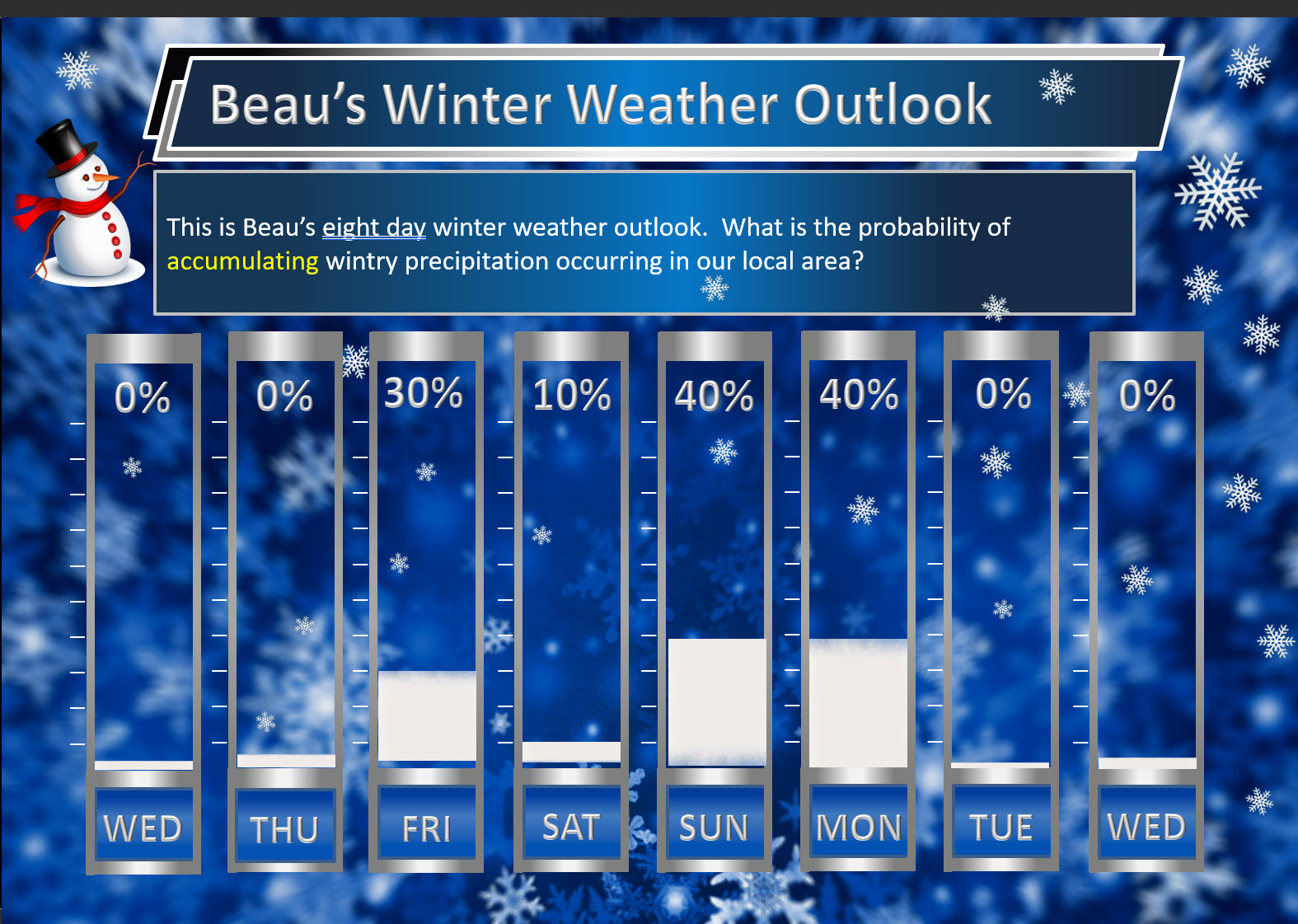
6. Is measurable snow and/or sleet in the forecast? Yes. Light snow accumulation is possible Friday afternoon and night. This could lead to icy roads. A flash freeze is possible. Accumulation of snow would be light, but since it will be so cold it would not take much to cause issues. Not overly concerned, but I would monitor radars and temperatures.
Snow is likely Sunday into Monday (centered on late Sunday into Monday morning). I will need to fine tune the exact time of the snows arrival.
7. Is freezing rain/ice in the forecast? Monitor. I am watching Sunday afternoon into Monday. This is likely a snow/sleet event. I am not overly concerned about freezing rain.
Freezing rain is rain that falls and instantly freezes on objects such as trees and power lines
.
Fire weather risk level.
Wednesday: 4. Low risk.
Wednesday night: 4. Low risk.
Thursday: 4. Low risk.
Thursday night. 4. Low risk.
Fire Weather Discussion
Dry and breezy conditions are expected today into Thursday. Another strong weather system will move through our region Thursday night into Friday, bringing widespread rain and very windy conditions. Rain will become a wintry mix, then snow, as precipitation tapers off from west to east late Friday afternoon into Friday night. Very cold arctic air will follow, as will another weather system that will bring snow to our region Sunday through Tuesday morning.
A Haines Index of 6 means a high potential for an existing fire to become large or exhibit erratic fire behavior, 5 means medium potential, 4 means low potential, and anything less than 4 means very low potential.
.
.
Wednesday, January 10, 2024
Confidence in the forecast? High Confidence
Wednesday Forecast: Becoming partly sunny. Breezy. Colder.
What is the chance of precipitation?
Far northern southeast Missouri ~ 0%
Southeast Missouri ~ 0%
The Missouri Bootheel ~ 0%
I-64 Corridor of southern Illinois ~ 0%
Southern Illinois ~ 0%
Extreme southern Illinois (southern seven counties) ~ 0%
Far western Kentucky (Purchase area) ~ 0%
The Pennyrile area of western KY ~ 0%
Northwest Kentucky (near Indiana border) ~ 0%
Northwest Tennessee ~ 0%
Coverage of precipitation:
Timing of the precipitation:
Far northern southeast Missouri ~ 40° to 44°
Southeast Missouri ~ 40° to 44°
The Missouri Bootheel ~ 42° to 44°
I-64 Corridor of southern Illinois ~ 40° to 42°
Southern Illinois ~ 40° to 44°
Extreme southern Illinois (southern seven counties) ~ 40° to 44°
Far western Kentucky ~ 40° to 44°
The Pennyrile area of western KY ~ 40° to 44°
Northwest Kentucky (near Indiana border) ~ 40° to 44°
Northwest Tennessee ~ 42° to 44°
Winds will be from this direction: West southwest 15 to 30 mph.
Wind chill or heat index (feels like) temperature forecast: 25° to 35°
What impacts are anticipated from the weather?
Should I cancel my outdoor plans? No
UV Index: 2. Low.
Sunrise: 7:10 AM
Sunset: 4:56 PM .
.
Wednesday Night Forecast: Partly cloudy.
What is the chance of precipitation?
Far northern southeast Missouri ~ 0%
Southeast Missouri ~ 0%
The Missouri Bootheel ~ 0%
I-64 Corridor of southern Illinois ~ 0%
Southern Illinois ~ 0%
Extreme southern Illinois (southern seven counties) ~ 0%
Far western Kentucky (Purchase area) ~ 0%
The Pennyrile area of western KY ~ 0%
Northwest Kentucky (near Indiana border) ~ 0%
Northwest Tennessee ~ 0%
Coverage of precipitation:
Timing of the precipitation:
Temperature range:
Far northern southeast Missouri ~ 26° to 28°
Southeast Missouri ~ 26° to 30°
The Missouri Bootheel ~ 30° to 34°
I-64 Corridor of southern Illinois ~ 26° to 28°
Southern Illinois ~ 26° to 30°
Extreme southern Illinois (southern seven counties) ~ 28° to 30°
Far western Kentucky ~ 28° to 32°
The Pennyrile area of western KY ~ 32° to 34°
Northwest Kentucky (near Indiana border) ~ 28° to 32°
Northwest Tennessee ~ 32° to 34°
Winds will be from this direction: South southwest 15 to 30 mph.
Wind chill or heat index (feels like) temperature forecast: 15° to 25°
What impacts are anticipated from the weather?
Should I cancel my outdoor plans? No
Moonrise: 6:44 AM
Moonset: 3:55 PM
The phase of the moon: New
.
Thursday, January 11, 2024
Confidence in the forecast? High Confidence
Thursday Forecast: Becoming partly sunny. Breezy.
What is the chance of precipitation?
Far northern southeast Missouri ~ 0%
Southeast Missouri ~ 0%
The Missouri Bootheel ~ 0%
I-64 Corridor of southern Illinois ~ 0%
Southern Illinois ~ 0%
Extreme southern Illinois (southern seven counties) ~ 0%
Far western Kentucky (Purchase area) ~ 0%
The Pennyrile area of western KY ~ 0%
Northwest Kentucky (near Indiana border) ~0%
Northwest Tennessee ~ 0%
Coverage of precipitation:
Timing of the precipitation:
Far northern southeast Missouri ~ 48° to 50°
Southeast Missouri ~ 48° to 50°
The Missouri Bootheel ~ 52° to 54°
I-64 Corridor of southern Illinois ~ 48° to 50°
Southern Illinois ~ 48° to 50°
Extreme southern Illinois (southern seven counties) ~ 48° to 52°
Far western Kentucky ~ 50° to 54°
The Pennyrile area of western KY ~ 52° to 55°
Northwest Kentucky (near Indiana border) ~ 48° to 52°
Northwest Tennessee ~ 52° to 54°
Winds will be from this direction: South southeast 10 to 20 mph.
Wind chill or heat index (feels like) temperature forecast: 45° to 50°
What impacts are anticipated from the weather?
Should I cancel my outdoor plans? No
UV Index: 2. Low.
Sunrise: 7:10 AM
Sunset: 4:57 PM .
.
Thursday Night Forecast: Increasing clouds. Rain likely. Windy. A chance of thunderstorms.
What is the chance of precipitation?
Far northern southeast Missouri ~ 90%
Southeast Missouri ~ 90%
The Missouri Bootheel ~ 90%
I-64 Corridor of southern Illinois ~ 90%
Southern Illinois ~ 90%
Extreme southern Illinois (southern seven counties) ~ 90%
Far western Kentucky (Purchase area) ~ 90%
The Pennyrile area of western KY ~ 90%
Northwest Kentucky (near Indiana border) ~ 90%
Northwest Tennessee ~ 90%
Coverage of precipitation: Widespread
Timing of the precipitation: Any given point of time
Temperature range:
Far northern southeast Missouri ~ 34° to 36°
Southeast Missouri ~ 34° to 36°
The Missouri Bootheel ~ 40° to 44°
I-64 Corridor of southern Illinois ~ 34° to 36°
Southern Illinois ~ 38° to 40°
Extreme southern Illinois (southern seven counties) ~38° to 40°
Far western Kentucky ~ 40° to 42°
The Pennyrile area of western KY ~ 40° to 44°
Northwest Kentucky (near Indiana border) ~ 38° to 40°
Northwest Tennessee ~ 40° to 44°
Winds will be from this direction: South southeast 15 to 40 mph
Wind chill or heat index (feels like) temperature forecast: 30° to 40°
What impacts are anticipated from the weather? Wet roadways. Lightning.
Should I cancel my outdoor plans? Have a plan B and monitor updates.
Moonrise: 7:42 AM
Moonset: 5:08 PM
The phase of the moon: New
.
Friday, January 12, 2024
Confidence in the forecast? High Confidence
Friday Forecast: Cloudy. Showers and thunderstorms likely. Turning colder. Rain may change to snow late in the day. Windy.
What is the chance of precipitation?
Far northern southeast Missouri ~ 90%
Southeast Missouri ~ 90%
The Missouri Bootheel ~ 90%
I-64 Corridor of southern Illinois ~ 90%
Southern Illinois ~ 90%
Extreme southern Illinois (southern seven counties) ~ 90%
Far western Kentucky (Purchase area) ~ 90%
The Pennyrile area of western KY ~ 90%
Northwest Kentucky (near Indiana border) ~ 90%
Northwest Tennessee ~ 90%
Coverage of precipitation: Numerous
Timing of the precipitation:
Far northern southeast Missouri ~ 43° to 46°
Southeast Missouri ~ 46° to 48°
The Missouri Bootheel ~ 50° to 54°
I-64 Corridor of southern Illinois ~ 46° to 48°
Southern Illinois ~ 46° to 48°
Extreme southern Illinois (southern seven counties) ~ 48° to 52°
Far western Kentucky ~ 48° to 52°
The Pennyrile area of western KY ~ 52° to 55°
Northwest Kentucky (near Indiana border) ~ 46° to 50°
Northwest Tennessee ~ 52° to 54°
Winds will be from this direction: South southwest becoming west northwest 20 to 45 mph.
Wind chill or heat index (feels like) temperature forecast: 35° to 45°
What impacts are anticipated from the weather? Wet roadways. Lighting. Monitor updates concerning the cold air behind the rain. Strong winds.
Should I cancel my outdoor plans? Yes. Have a plan B and monitor updates.
UV Index: 2. Low.
Sunrise: 7:09 AM
Sunset: 4:58 PM .
.
Friday Night Forecast: Cloudy. Snow showers. Bitterly colder. Windy. Watch for icy roads if temperatures drop while we still have snow showers in the region.
What is the chance of precipitation?
Far northern southeast Missouri ~ 60%
Southeast Missouri ~ 40%
The Missouri Bootheel ~ 40%
I-64 Corridor of southern Illinois ~ 70%
Southern Illinois ~ 70%
Extreme southern Illinois (southern seven counties) ~ 70%
Far western Kentucky (Purchase area) ~ 70%
The Pennyrile area of western KY ~ 70%
Northwest Kentucky (near Indiana border) ~ 70%
Northwest Tennessee ~ 60%
Coverage of precipitation: Scattered
Timing of the precipitation: Any given point of time
Temperature range:
Far northern southeast Missouri ~ 10° to 14°
Southeast Missouri ~ 13° to 16°
The Missouri Bootheel ~ 18° to 22°
I-64 Corridor of southern Illinois ~ 11° to 15
Southern Illinois ~ 12° to 15°
Extreme southern Illinois (southern seven counties) ~13° to 16°
Far western Kentucky ~ 14° to 18°
The Pennyrile area of western KY ~ 22° to 24°
Northwest Kentucky (near Indiana border) ~ 15° to 20°
Northwest Tennessee ~ 20° to 24°
Winds will be from this direction: West northwest 15 to 45 mph
Wind chill or heat index (feels like) temperature forecast: -5° to 10°
What impacts are anticipated from the weather? Wet roadways. Monitor for the risk of icy roadways. Bitterly cold wind chill values. High winds.
Should I cancel my outdoor plans? Have a plan B and monitor updates.
Moonrise: 8:29 AM
Moonset: 6:26 PM
The phase of the moon: Waxing crescent.
.
Saturday, January 13, 2024
Confidence in the forecast? High Confidence
Saturday Forecast: Partly cloudy. Cold. Windy.
What is the chance of precipitation?
Far northern southeast Missouri ~ 0%
Southeast Missouri ~ 0%
The Missouri Bootheel ~ 0%
I-64 Corridor of southern Illinois ~ 0%
Southern Illinois ~ 0%
Extreme southern Illinois (southern seven counties) ~ 0%
Far western Kentucky (Purchase area) ~ 0%
The Pennyrile area of western KY ~ 0%
Northwest Kentucky (near Indiana border) ~ 0%
Northwest Tennessee ~ 0%
Coverage of precipitation:
Timing of the precipitation:
Far northern southeast Missouri ~ 26° to 30°
Southeast Missouri ~ 28° to 32°
The Missouri Bootheel ~ 30° to 34°
I-64 Corridor of southern Illinois ~ 26° to 30°
Southern Illinois ~ 28° to 32°
Extreme southern Illinois (southern seven counties) ~ 30° to 32°
Far western Kentucky ~ 30° to 34°
The Pennyrile area of western KY ~ 30° to 34°
Northwest Kentucky (near Indiana border) ~ 30° to 32°
Northwest Tennessee ~ 33° to 36°
Winds will be from this direction: West northwest 15 to 35 mph.
Wind chill or heat index (feels like) temperature forecast: -5° to 15°
What impacts are anticipated from the weather? Cold wind chill values.
Should I cancel my outdoor plans? No, but it will be cold.
UV Index: 2. Low.
Sunrise: 7:09 AM
Sunset: 4:59 PM .
.
Saturday Night Forecast: Mostly clear early, then increasing clouds. Bitterly cold.
What is the chance of precipitation?
Far northern southeast Missouri ~ 0%
Southeast Missouri ~ 0%
The Missouri Bootheel ~ 0%
I-64 Corridor of southern Illinois ~ 0%
Southern Illinois ~ 0%
Extreme southern Illinois (southern seven counties) ~ 0%
Far western Kentucky (Purchase area) ~ 0%
The Pennyrile area of western KY ~ 0%
Northwest Kentucky (near Indiana border) ~ 0%
Northwest Tennessee ~ 0%
Coverage of precipitation:
Timing of the precipitation:
Temperature range:
Far northern southeast Missouri ~ 5° to 10°
Southeast Missouri ~ 12° to 14°
The Missouri Bootheel ~ 16° to 18°
I-64 Corridor of southern Illinois ~ 8° to 12°
Southern Illinois ~ 10° to 15°
Extreme southern Illinois (southern seven counties) ~12° to 15°
Far western Kentucky ~ 14° to 16°
The Pennyrile area of western KY ~ 16° to 20°
Northwest Kentucky (near Indiana border) ~ 14° to 18°
Northwest Tennessee ~ 20° to 22°
Winds will be from this direction: West northwest 15 to 35 mph.
Wind chill or heat index (feels like) temperature forecast: -10° to 5°
What impacts are anticipated from the weather? Cold wind chills.
Should I cancel my outdoor plans? No, but it will be cold.
Moonrise: 9:08 AM
Moonset: 7:43 PM
The phase of the moon: Waxing crescent.
.
Sunday, January 14, 2024
Confidence in the forecast? Medium Confidence
Sunday Forecast: Increasing clouds. A chance of mainly afternoon snow. Cold.
What is the chance of precipitation?
Far northern southeast Missouri ~ 40%
Southeast Missouri ~ 40%
The Missouri Bootheel ~ 40%
I-64 Corridor of southern Illinois ~ 40%
Southern Illinois ~ 40%
Extreme southern Illinois (southern seven counties) ~ 40%
Far western Kentucky (Purchase area) ~ 40%
The Pennyrile area of western KY ~ 40%
Northwest Kentucky (near Indiana border) ~ 30%
Northwest Tennessee ~ 40%
Coverage of precipitation: Scattered
Timing of the precipitation: Mainly afternoon. The later in the day the higher the chances.
Far northern southeast Missouri ~ 15° to 20°
Southeast Missouri ~ 18° to 20°
The Missouri Bootheel ~ 23° to 26°
I-64 Corridor of southern Illinois ~ 18° to 20°
Southern Illinois ~ 20° to 22°
Extreme southern Illinois (southern seven counties) ~ 22° to 25°
Far western Kentucky ~ 24° to 26°
The Pennyrile area of western KY ~ 25° to 30°
Northwest Kentucky (near Indiana border) ~ 24° to 26°
Northwest Tennessee ~ 28° to 32°
Winds will be from this direction: North northwest 15 to 35 mph.
Wind chill or heat index (feels like) temperature forecast: -5° to 15°
What impacts are anticipated from the weather? Cold wind chill values. Icy roads.
Should I cancel my outdoor plans? Have a plan B because of the cold and potential snow. Monitor updates.
UV Index: 1. Low.
Sunrise: 7:08 AM
Sunset: 4:59 PM .
.
Sunday Night Forecast: Snow likely. Some snow accumulation possible. At this time, it appears that a widespread one to four snow event will be possible. The system is still five days out. An accurate snow forecast is usually issued 24 to 48 hours in advance.
What is the chance of precipitation?
Far northern southeast Missouri ~ 70%
Southeast Missouri ~ 90%
The Missouri Bootheel ~ 90%
I-64 Corridor of southern Illinois ~ 60%
Southern Illinois ~ 70%
Extreme southern Illinois (southern seven counties) ~ 90%
Far western Kentucky (Purchase area) ~ 90%
The Pennyrile area of western KY ~ 90%
Northwest Kentucky (near Indiana border) ~ 70%
Northwest Tennessee ~ 100%
Coverage of precipitation: Widespread
Timing of the precipitation: Any given point of time.
Temperature range:
Far northern southeast Missouri ~ -2° to 0°
Southeast Missouri ~ 0° to 4°
The Missouri Bootheel ~ 3° to 6°
I-64 Corridor of southern Illinois ~ -2° to 2°
Southern Illinois ~ 2° to 4°
Extreme southern Illinois (southern seven counties) ~ 2° to 5°
Far western Kentucky ~ 0° to 4°
The Pennyrile area of western KY ~ 3° to 6°
Northwest Kentucky (near Indiana border) ~ 0° to 5°
Northwest Tennessee ~ 2° to 5°
Winds will be from this direction: West northwest 15 to 35 mph.
Wind chill or heat index (feels like) temperature forecast: -15° to 0°
What impacts are anticipated from the weather? Cold wind chills. Icy roads. Blowing snow. Snow.
Should I cancel my outdoor plans? Have a plan B.
Moonrise: 9:08 AM
Moonset: 7:43 PM
The phase of the moon: Waxing crescent.
.
.
Click here if you would like to return to the top of the page.
-
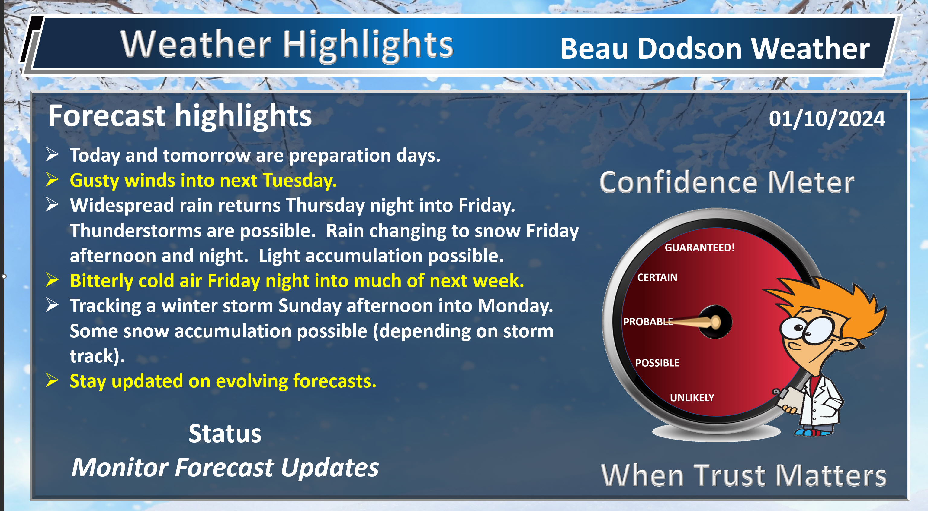
- Now is the time to prepare for the bitterly cold air. Today and tomorrow.
- Gusty winds today into next Tuesday. Ranging from 20 to 40 mph. Gusts Friday/Friday night could top 40 mph.
- Widespread rain returns Thursday night and Friday. Rumble thunder possible.
- Much colder Friday evening into next week. Falling temperatures Friday behind the arctic cold front.
- Snow showers possible Friday afternoon and night. Watch for slick spots as temps rapidly fall. Flash freeze possible.
- Bitterly cold air this weekend into much of next week. Pipe busting cold.
- Tracking a winter storm Sunday afternoon into Monday.
Weather advice:
Make sure you have three to five ways of receiving your severe weather information.
Now is the time to prepare for pipe busting cold weather. That will arrive this weekend into next week.
Accumulating snow appears likely Sunday PM into Monday. Still early for numbers, but some icy roads are likely in the region. School closings are possible next week.
Forecast Discussion
Good day, everyone.
I am tracking multiple weather threats. As mentioned above.
No weather concerns today, tonight, or tomorrow. Gusty wind from time to time, but it will be subsiding.
Temperatures today and tomorrow will be seasonably cool. Not too cold. Not too mild! Highs Thursday could even hit 50 degrees. This is why today and tomorrow is the time to prepare for what is coming.
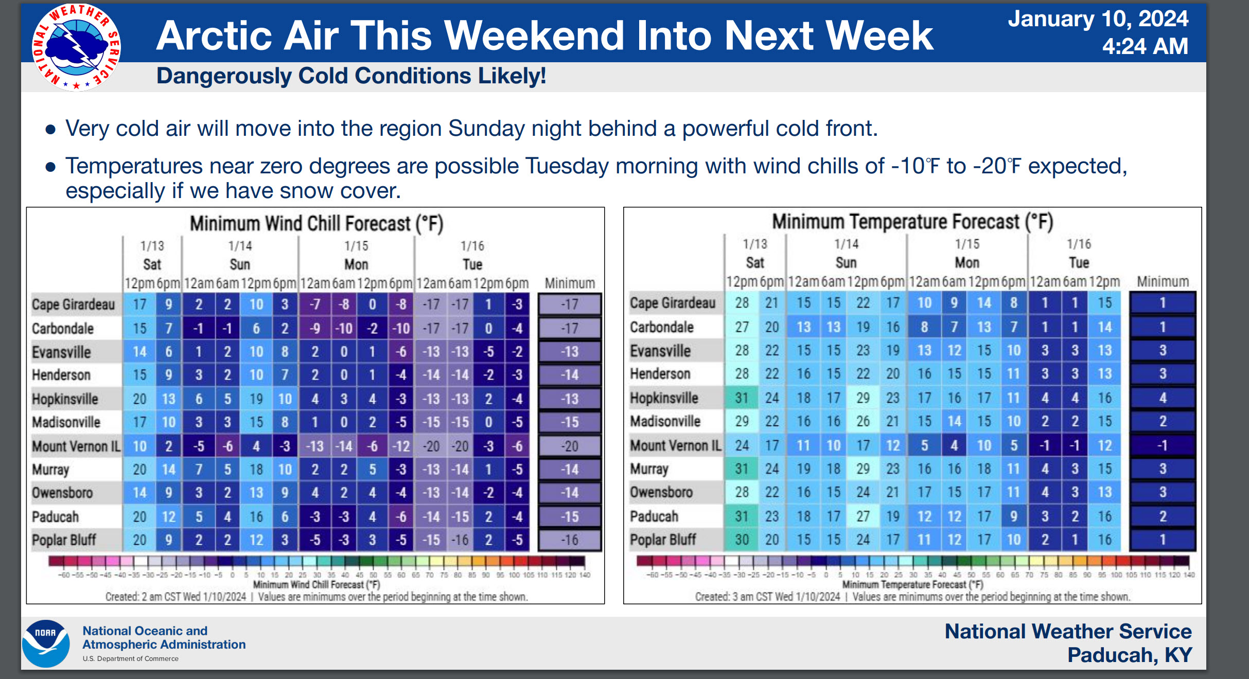
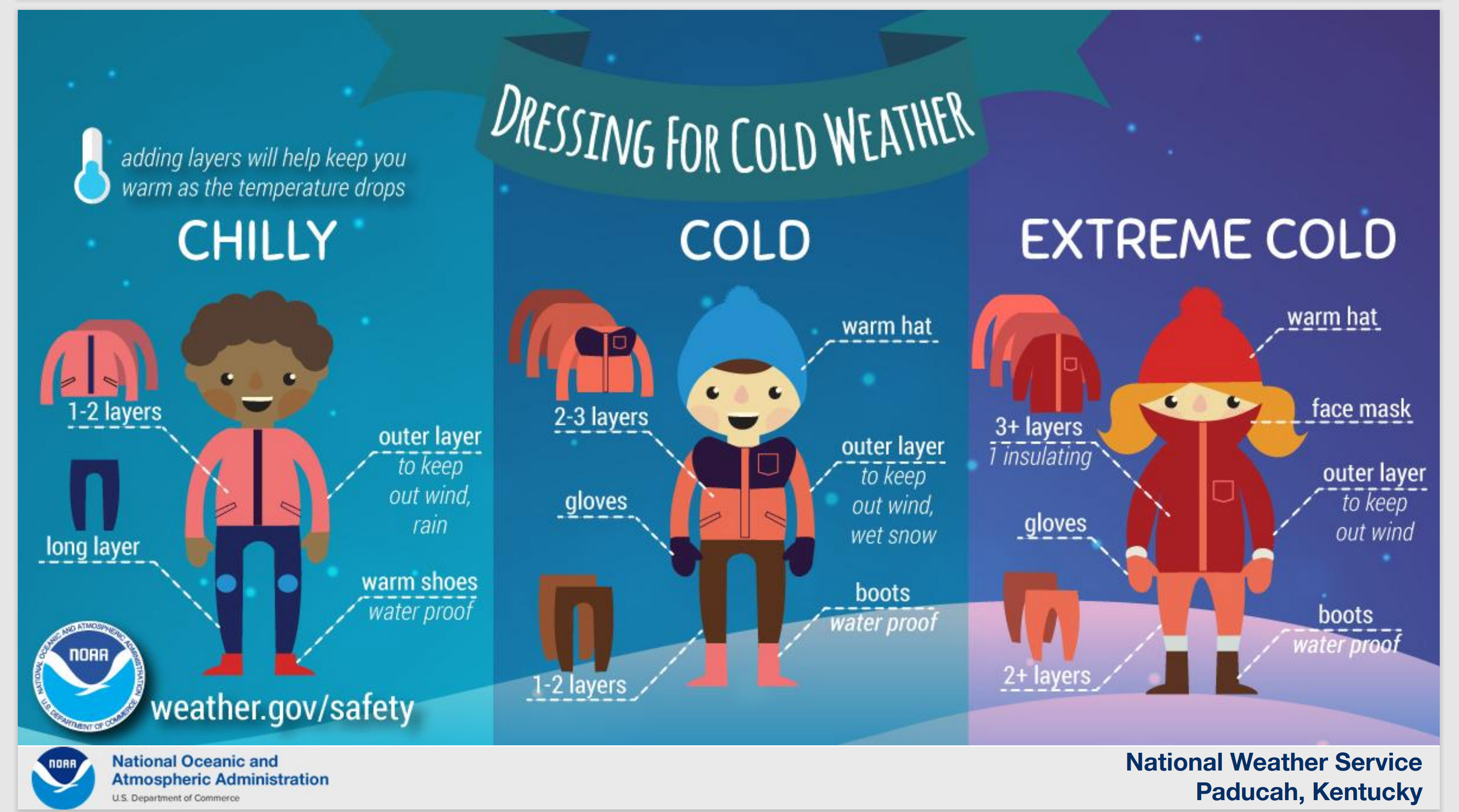
What is coming is a prolonged period of cold to bitterly cold temperatures. There will be some nights with wind chill values of -10 to -20. BRrr and double Brrr. That is dangerously cold. Exposed skin can have frostbite in a matter of minutes. Let’s be careful.
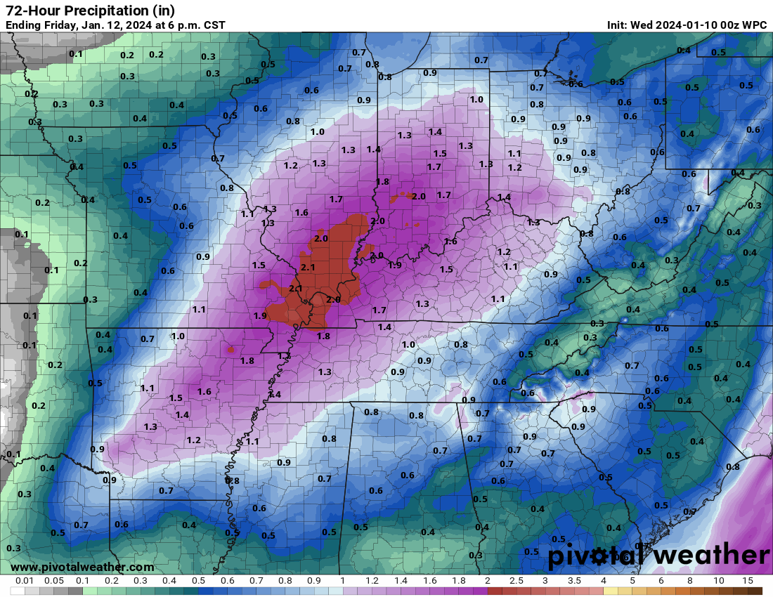
Our next big rain event arrives Thursday night into Friday. Widespread showers and thunderstorms across the region. Rainfall totals of one to two inches is anticipated.
I have been closely monitoring the track of Friday’s low. For now, it appears the bulk of the snow with this event will occur north and west of my forecast counties. With that said, the rain may end as snow showers late Friday and Friday night. Gusty winds, bitterly cold air, and snow showers. What a combination.
There could be black ice Friday night.
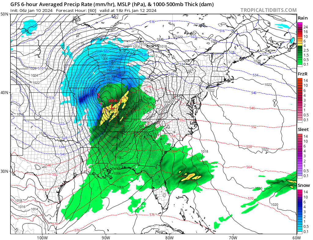
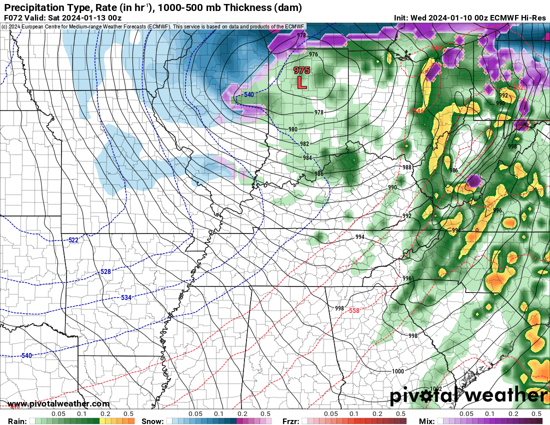
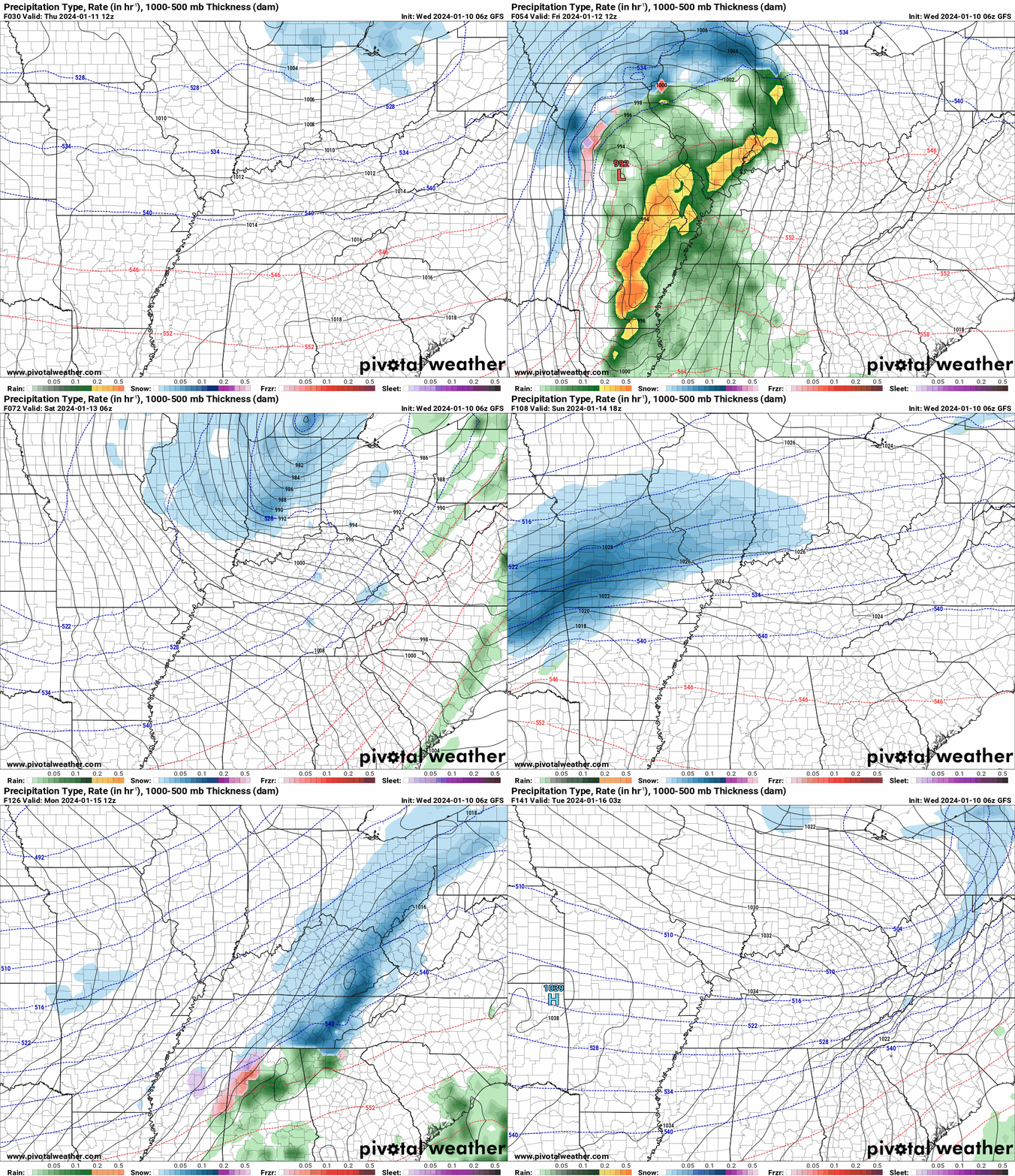
Here are some model depictions of that deep low pressure center. This is quite the low pressure center for any time of the year. Deep. I suspect this ends up being a blizzard Friday across parts of Missouri and Illinois. We will see what the NWS does.
GFS model.
Green and yellow = rain. Blue is snow. Deep blue represents heavy snow. Notice how the L passes over us. That is the center of low pressure. Notice how the snow is to the west northwest of the low. Rain to the east southeast.
This is 12 PM Friday.
Then, by Friday afternoon the low is moving away from the area. The rain could end as snow. Any accumulation would be light. A dusting to an inch. I am not overly concerned about this, but it is something to monitor.
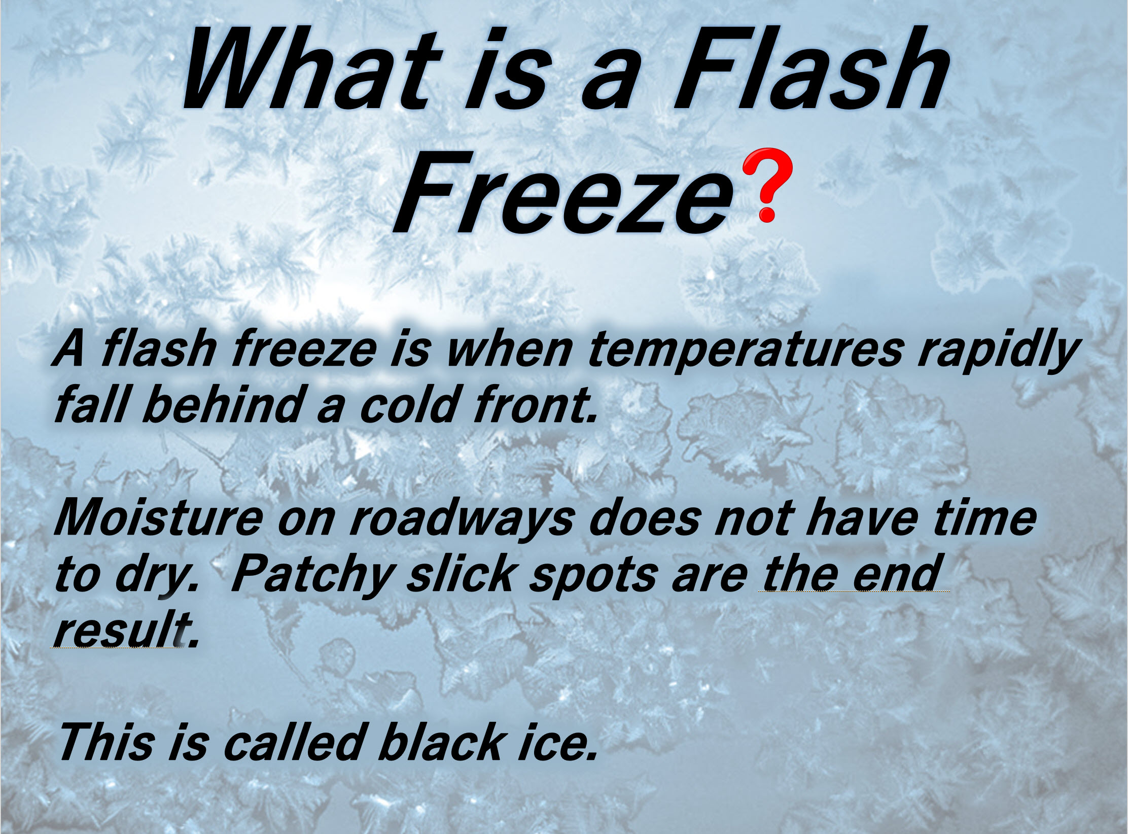
Bitterly cold air arrives Friday afternoon and night. Temperatures will fall Friday afternoon and a flash freeze is possible Friday night. A flash freeze occurs when temperatures rapidly fall and moisture remains on roadways and parking lots.
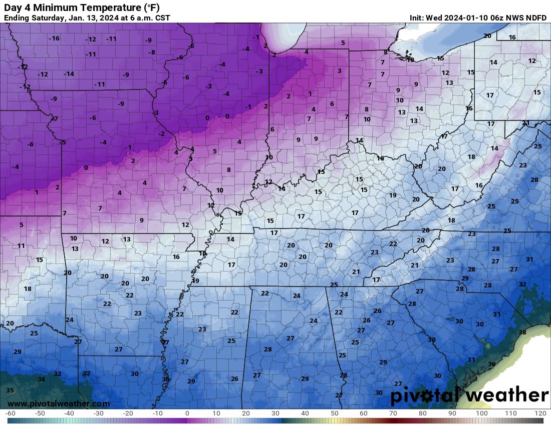
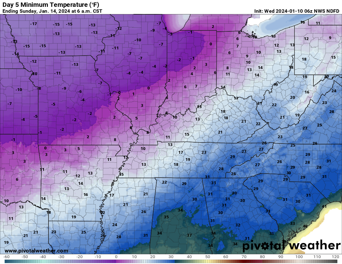
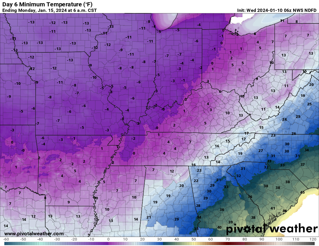
Bitterly cold air arrives Friday night and that cold air will linger into most of next week.
Saturday morning lows
Sunday morning lows
Monday morning lows
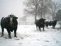
This will be harsh on outdoor animals and livestock.
Wind chills will dip below ten degrees Friday night. Low wind chill values will be the theme Friday night into much of next week. Occasionally, those wind chill values will dip well below zero. Especially if we have a snow pack.
The NWS may need to issue a wind chill advisory. Either way, it will be bitterly cold.
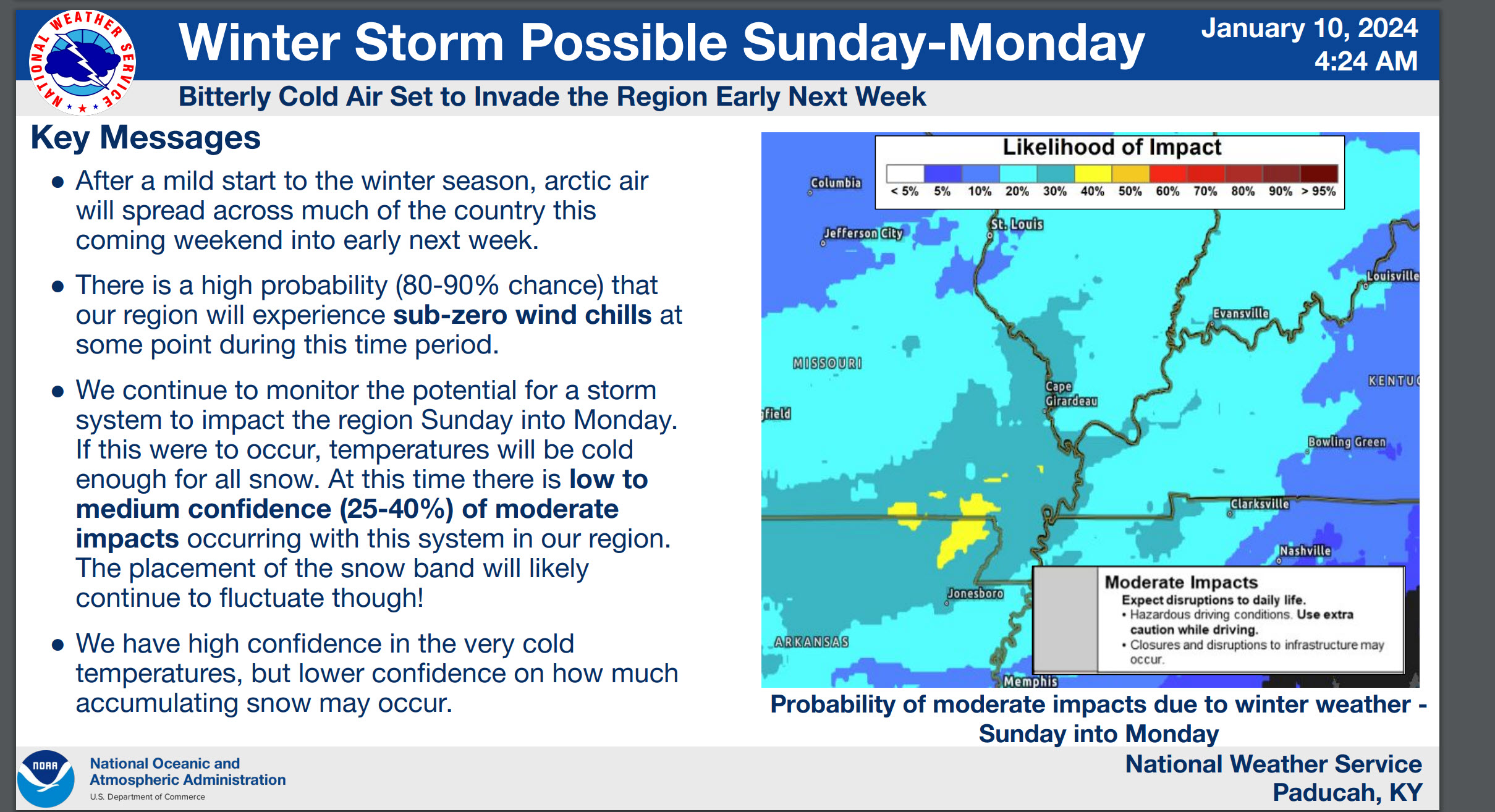
Here is what the NWS is thinking. I have been saying the same. I believe the risk of heavier snow is higher over Arkansas into the Missouri Bootheel.
There will be adjustments to the forecast. It is impossible to forecast accurate snow totals five days out. I do believe, however, we have a decent handle on the setup. Without any drastic changes in the storms path, most of us will receive some snow with this event.
Double click images to enlarge them
A winter storm will move into the region Sunday afternoon into Monday. This is the best chance of snow this winter, thus far. Accumulating snow and sleet will be possible area-wide.
This Sunday afternoon into Monday system will track farther south and east than recent events. That means our region will be in the cold sector. This will be an overrunning event.
Overrunning events can produce quite a bit of precipitation. Let’s keep an eye on this one. Confidence is increasing that we will have some wintry weather later this weekend into early next week.
At this time, and keep in mind the storm is still FIVE days away, I am forecasting a widespread one to four inch snow event. I certainly can’t rule out some bands of four to six inches. Where that would be placed remains a question.
The overall trend in the system has been to push it slightly farther south and east. Although, some models yesterday shifted northwest by about 30 miles. All of that is within the margin of error five days out.
Since it will be so cold, this will be a dry snow.
Whatever does fall is not going anywhere. It will be bitterly cold next week. If we have a snowpack then temperatures could dip into the single digits with wind chill values below zero a good bet.
Now is the time to prepare for bitterly cold air. This is pipe freezing/busting weather.
.
Click here if you would like to return to the top of the page.
This outlook covers southeast Missouri, southern Illinois, western Kentucky, and far northwest Tennessee.
.
Today’s Storm Prediction Center’s Severe Weather Outlook
Light green is where thunderstorms may occur but should be below severe levels.
Dark green is a level one risk. Yellow is a level two risk. Orange is a level three (enhanced) risk. Red is a level four (moderate) risk. Pink is a level five (high) risk.
One is the lowest risk. Five is the highest risk.
A severe storm is one that produces 58 mph wind or higher, quarter size hail, and/or a tornado.
Explanation of tables. Click here.

.
Tornado Probability Outlook

.
Large Hail Probability Outlook

.
High wind Probability Outlook

.
Tomorrow’s severe weather outlook.

.
Day Three Severe Weather Outlook

.

.
The images below are from NOAA’s Weather Prediction Center.
24-hour precipitation outlook..
 .
.
.
48-hour precipitation outlook.
. .
.
![]()
_______________________________________
.

Click here if you would like to return to the top of the page.
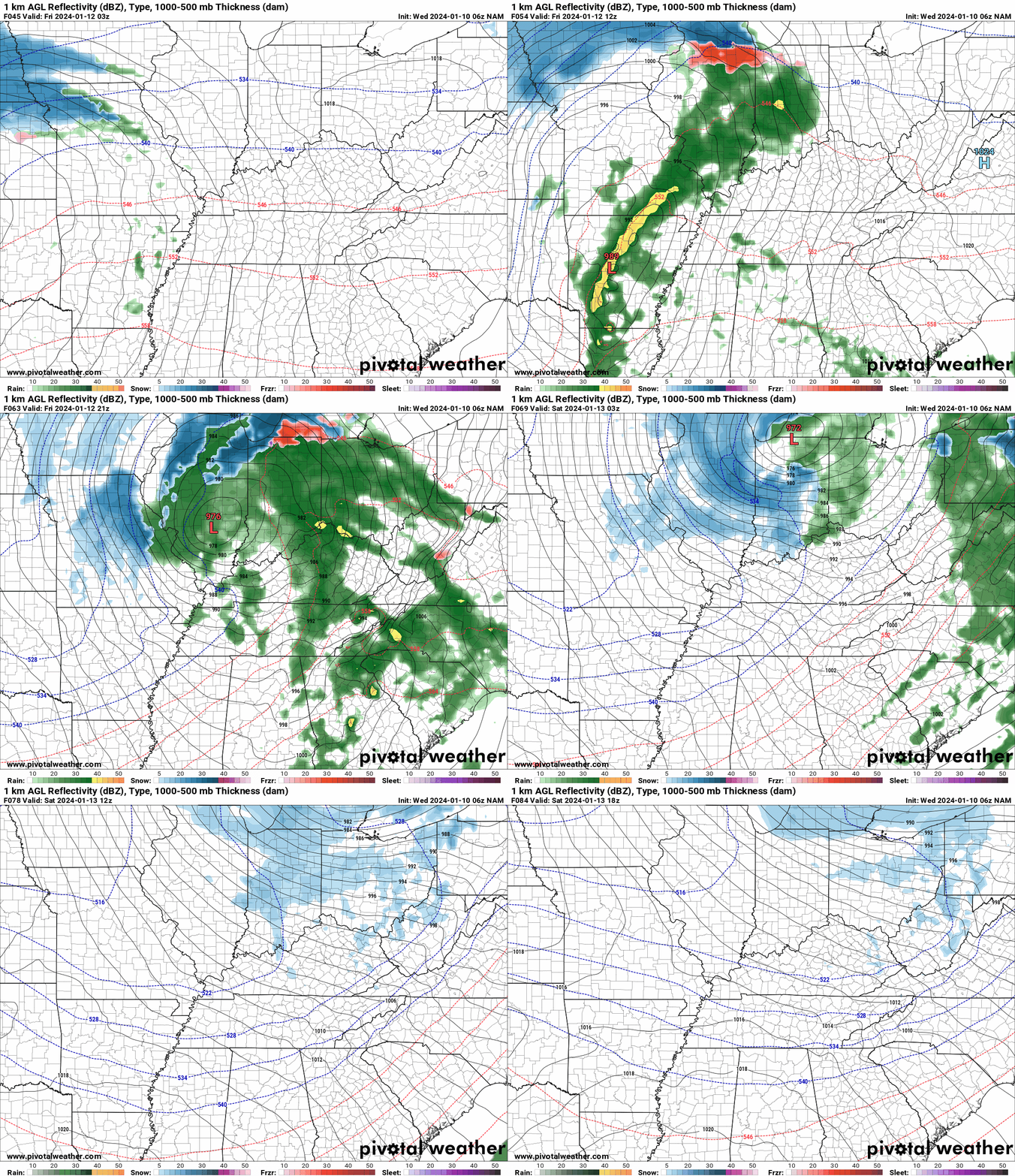
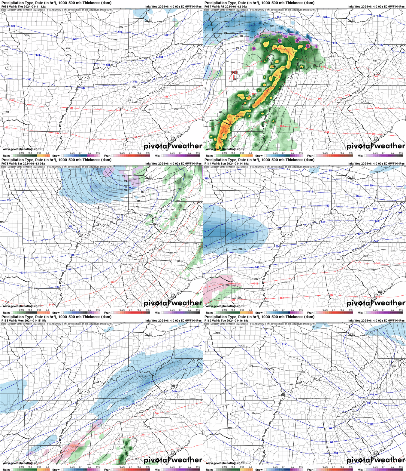
Again, as a reminder, these are models. They are never 100% accurate. Take the general idea from them.
What should I take from these?
- The general idea and not specifics. Models usually do well with the generalities.
- The time-stamp is located in the upper left corner.
.
What am I looking at?
You are looking at computer model data. Meteorologists use many different models to forecast the weather.
Occasionally, these maps are in Zulu time. 12z=7 AM. 18z=1 PM. 00z=7 PM. 06z=1 AM
Green represents light rain. Dark green represents moderate rain. Yellow and orange represent heavier rain.
.
This animation is the Hrrr Model.
Green is rain. Yellow and orange are heavier rain. Pink is a wintry mix. Blue is snow. Dark blue is heavier snow.
Occasionally, these maps are in Zulu time. 12z=6 AM. 18z=12 PM. 00z=6 PM. 06z=12 AM
Double click images to enlarge them.
.
This animation is the NAM Model.
Green is rain. Yellow and orange are heavier rain. Pink is a wintry mix. Blue is snow. Dark blue is heavier snow.
Occasionally, these maps are in Zulu time. 12z=6 AM. 18z=12 PM. 00z=6 PM. 06z=12 AM
Double click images to enlarge them.
.
This animation is the GFS Model.
Green is rain. Yellow and orange are heavier rain. Pink is a wintry mix. Blue is snow. Dark blue is heavier snow.
Occasionally, these maps are in Zulu time. 12z=6 AM. 18z=12 PM. 00z=6 PM. 06z=12 AM
Double click images to enlarge them.
.
This animation is the EC Model.
Green is rain. Yellow and orange are heavier rain. Pink is a wintry mix. Blue is snow. Dark blue is heavier snow.
Occasionally, these maps are in Zulu time. 12z=6 AM. 18z=12 PM. 00z=6 PM. 06z=12 AM
Double click images to enlarge them.
..![]()

.
Click here if you would like to return to the top of the page.
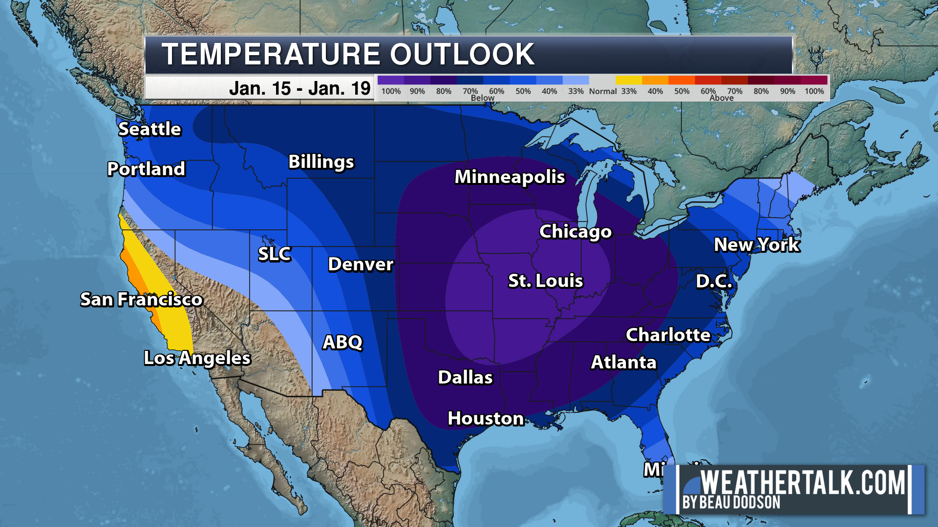
.Average high temperatures for this time of the year are around 45 degrees.
Average low temperatures for this time of the year are around 28 degrees.
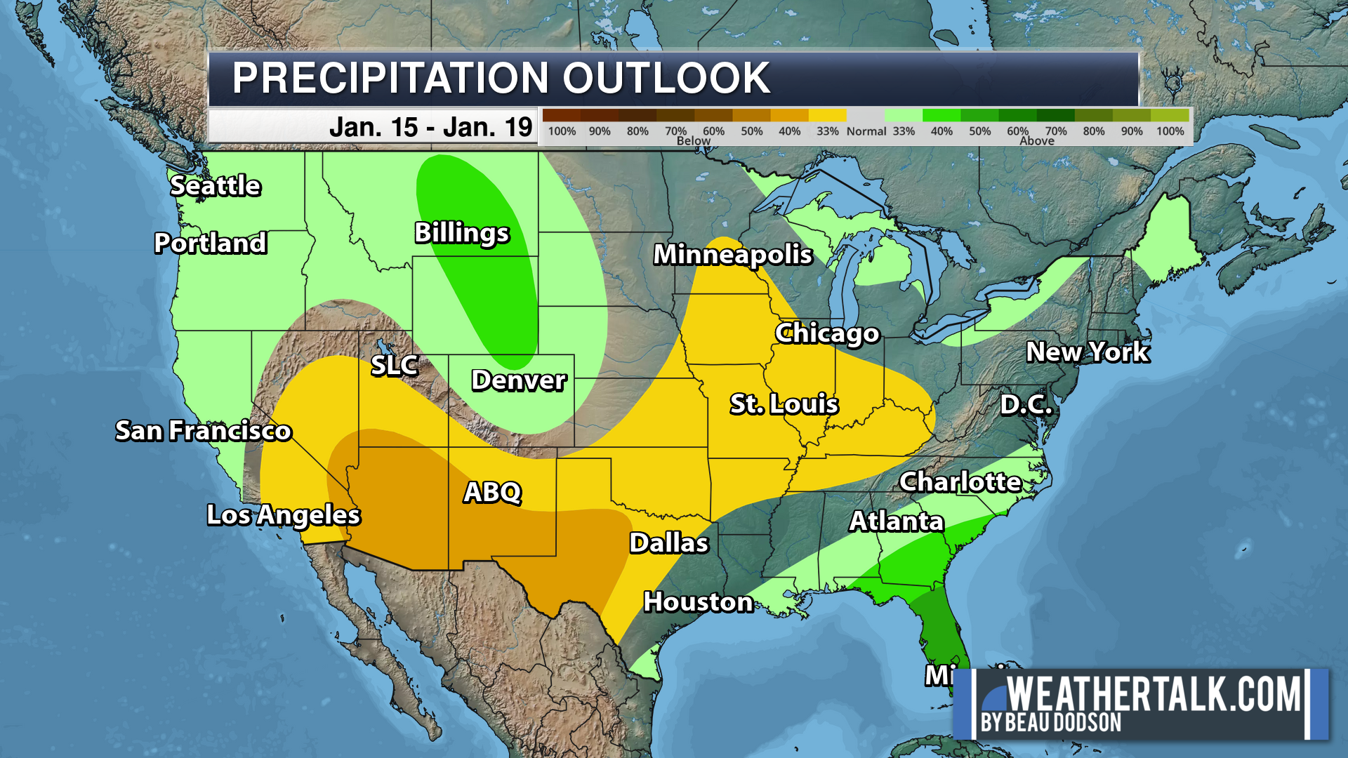
Average precipitation during this time period ranges from 0.50″ to 1.00″
Six to Ten Day Outlook.
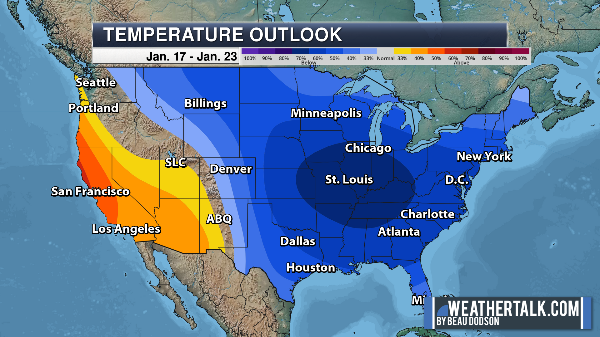
Blue is below average. Red is above average. The no color zone represents equal chances.
Average highs for this time of the year are in the lower 60s. Average lows for this time of the year are in the lower 40s.
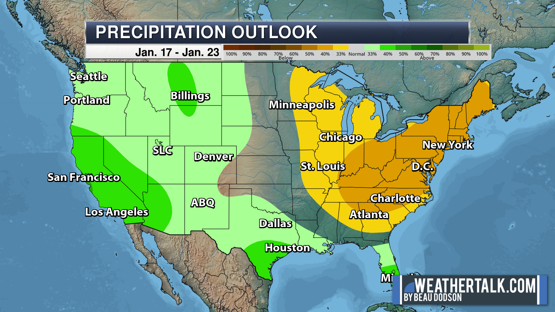
Green is above average precipitation. Yellow and brown favors below average precipitation. Average precipitation for this time of the year is around one inch per week.
.

Average low temperatures for this time of the year are around 28 degrees.
Average precipitation during this time period ranges from 0.50″ to 1.00″
.
.
![]()
The app is for subscribers. Subscribe at www.weathertalk.com/welcome then go to your app store and search for WeatherTalk
Subscribers, PLEASE USE THE APP. ATT and Verizon are not reliable during severe weather. They are delaying text messages.
The app is under WeatherTalk in the app store.
Apple users click here
Android users click here
.

Radars and Lightning Data
Interactive-city-view radars. Clickable watches and warnings.
https://wtalk.co/B3XHASFZ
If the radar is not updating then try another one. If a radar does not appear to be refreshing then hit Ctrl F5. You may also try restarting your browser.
Backup radar site in case the above one is not working.
https://weathertalk.com/morani
Regional Radar
https://imagery.weathertalk.com/prx/RadarLoop.mp4
** NEW ** Zoom radar with chaser tracking abilities!
ZoomRadar
Lightning Data (zoom in and out of your local area)
https://wtalk.co/WJ3SN5UZ
Not working? Email me at beaudodson@usawx.com
National map of weather watches and warnings. Click here.
Storm Prediction Center. Click here.
Weather Prediction Center. Click here.
.

Live lightning data: Click here.
Real time lightning data (another one) https://map.blitzortung.org/#5.02/37.95/-86.99
Our new Zoom radar with storm chases
.
.

Interactive GOES R satellite. Track clouds. Click here.
GOES 16 slider tool. Click here.
College of DuPage satellites. Click here
.

Here are the latest local river stage forecast numbers Click Here.
Here are the latest lake stage forecast numbers for Kentucky Lake and Lake Barkley Click Here.
.
.
Find Beau on Facebook! Click the banner.









 .
.