We have a few sponsors that are helping cover new technology costs! Check them out.
Heating problems?
One Hour Heating and Air – Click Here

Connected and Protected.
They Specialize in Audio, Video, Networking, Security, Cameras, Electrical, New Construction, Remodels, and retrofitting Jobs. Experience the future of smart living and unmatched security with Connected & Protected Solutions today.
Link – Click here

Roof damage from recent storms? Link – Click here


Click one of the links below to take you directly to that section
![]()
![]()
![]()
![]()
![]()
.

.
Seven Day Hazardous Weather Outlook
1. Is lightning in the forecast? YES. Possible late tonight into Thursday. Possible on Saturday and Saturday night.
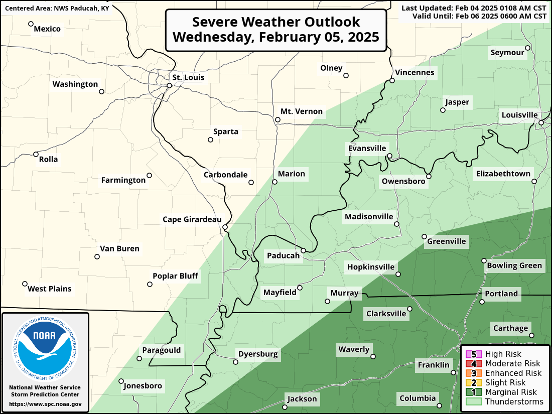
2. Are severe thunderstorms in the forecast? MONITOR. The SPC has outlined a marginal level one risk for areas east of LBL Wednesday evening and night. I am monitoring Saturday.
Here is the Wednesday Severe Weather Outlook. Light green simply means lightning is possible. The dark green zone is where a few storms could produce hail and damaging wind gusts. A low tornado risk.
This is mainly for the late afternoon and overnight hours (Wednesday)
3. Is flash flooding in the forecast? NOT AT THIS TIME.
4. Will non-thunderstorm winds top 40 mph? NO.
6. Will the wind chill dip below 10 degrees? NOT AT THIS TIME. I will monitor next Tuesday.
7. Is measurable snow and/or sleet in the forecast? MONITOR. I am monitoring Monday afternoon into Wednesday.
8. Is freezing rain in the forecast? MONITOR. I am monitoring Monday afternoon into Wednesday.
.
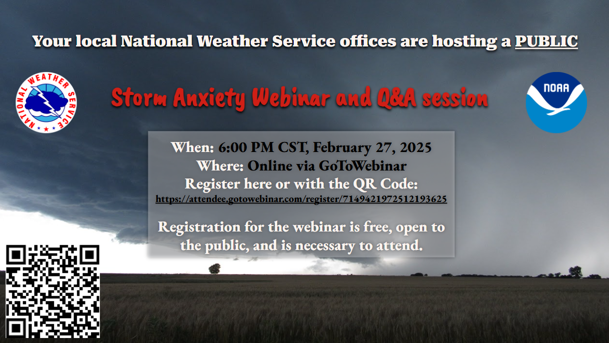
Do you have storm anxiety? Or, perhaps someone you know does.
The Paducah, Kentucky, NWS has announced a storm anxiety webinar.
the webinar on storm anxiety has been rescheduled to Feb. 27 at 6 PM CST!
The registration link is
https://attendee.gotowebinar.com/register/7149421972512193625
.

.
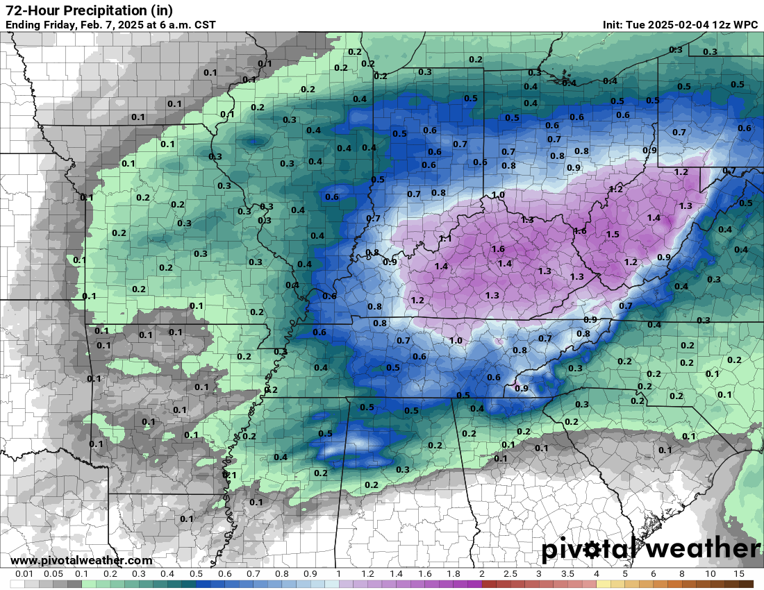
The images below are from NOAA’s Weather Prediction Center.
24-hour precipitation outlook..
 .
.
.
48-hour precipitation outlook.
.
.
Field and Brush Fire weather risk level.
Tuesday: 4. Low risk.
Tuesday night: 4. Low risk.
Wednesday: 4. Low risk.
Wednesday night: 4. Low risk.
Fire Weather Discussion
Decreasing winds today will lead to poor dispersion with mixing heights around 2500 feet and minimum humidity of 50-60%. Widespread rain can be expected Wednesday through Thursday.
A Haines Index of 6 means a high potential for an existing fire to become large or exhibit erratic fire behavior, 5 means medium potential, 4 means low potential, and anything less than 4 means very low potential.
.

Notes:
THE FORECAST WILL TO VARY FROM LOCATION TO LOCATION.
Scroll down to see your local forecast details.
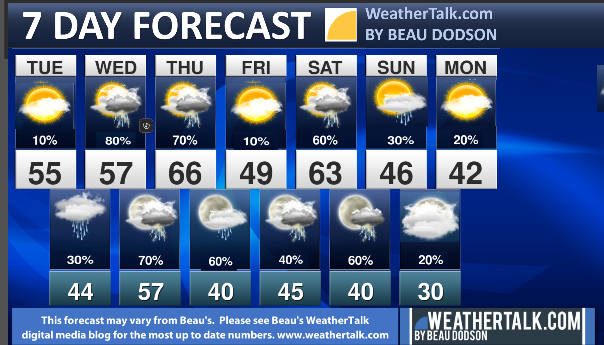
Seven-day forecast for southeast Missouri, southern Illinois, western Kentucky, and western Tennessee.
This is a BLEND for the region. Scroll further down to see the region by region forecast.
–
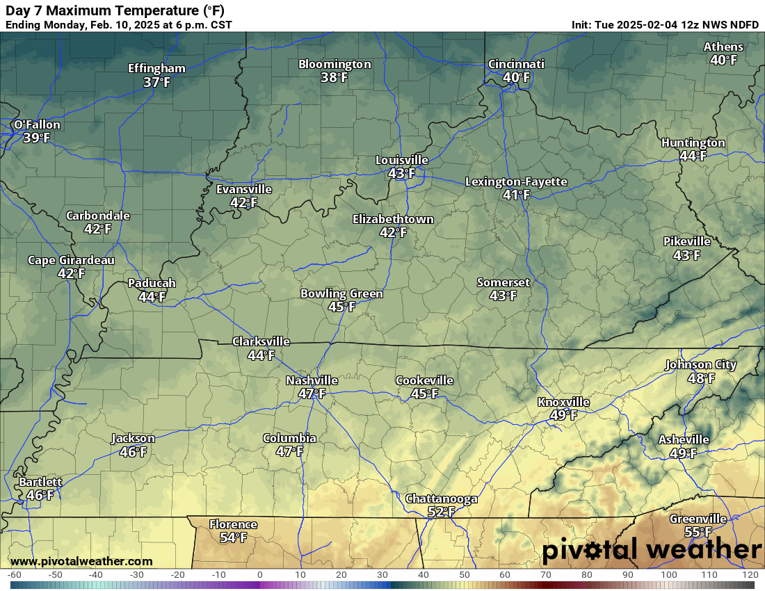
-> A WIDE RANGE OF TEMPERATURES THIS WEEK. SEE THE DAILY NUMBERS FARTHER DOWN IN THIS BLOG UPDATE. This graphic shows an average across the region.
For example, look at tomorrow’s temperatures. Notice the large range.

.
.
Beau’s Seven Day Video Outlook
.
A quick glance. 48-hour forecast Graphics


![]()
.
.
Tuesday Forecast: Intervals of clouds. Chilly. Breezy, at times.
What is the chance of precipitation?
Far northern southeast Missouri ~ 5%
Southeast Missouri ~ 5%
The Missouri Bootheel ~ 5%
I-64 Corridor of southern Illinois ~ 0%
Southern Illinois ~ 0%
Extreme southern Illinois (southern seven counties) ~ 0%
Far western Kentucky (Purchase area) ~ 0%
The Pennyrile area of western KY ~ 0%
Northwest Kentucky (near Indiana border) ~ 0%
Northwest Tennessee ~ 10%
Coverage of precipitation:
Timing of the precipitation:
Temperature range:
Far northern southeast Missouri: 44° to 49°
Southeast Missouri: 50° to 52°
The Missouri Bootheel: 50° to 54°
I-64 Corridor of southern Illinois: 44° to 48°
Southern Illinois: 44° to 48°
Extreme southern Illinois (southern seven counties): 48° to 52°
Far western Kentucky: 50° to 52°
The Pennyrile area of western Kentucky: 52° to 54°
Northwest Kentucky (near Indiana border): 48° to 52°
Northwest Tennessee: 52° to 55°
Winds will be from this direction: North northeast at 8 to 16 mph. Higher gusts possible.
Wind chill or heat index (feels like) temperature forecast: 34° to 44° during the morning. In the 40s and 50s during the afternoon.
What impacts are anticipated from the weather?
Should I cancel my outdoor plans? No
UV Index: 2. Low.
Sunrise: 6:55 AM
Sunset: 5:24 PM
.
Tuesday Night Forecast: Mostly cloudy. A chance of showers. A thunderstorm will be possible.
What is the chance of precipitation?
Far northern southeast Missouri ~ 40%
Southeast Missouri ~ 60%
The Missouri Bootheel ~ 40%
I-64 Corridor of southern Illinois ~ 40%
Southern Illinois ~ 40%
Extreme southern Illinois (southern seven counties) ~ 40%
Far western Kentucky (Purchase area) ~ 40%
The Pennyrile area of western KY ~ 40%
Northwest Kentucky (near Indiana border) ~ 40%
Northwest Tennessee ~ 40%
Coverage of precipitation: Scattered
Timing of the precipitation: Mainly late at night.
Temperature range:
Far northern southeast Missouri: 33° to 36°
Southeast Missouri: 34° to 38°
The Missouri Bootheel: 38° to 42°
I-64 Corridor of southern Illinois: 34° to 36°
Southern Illinois: 38° to 42°
Extreme southern Illinois (southern seven counties): 42° to 44°
Far western Kentucky (Purchase area): 42° to 44°
The Pennyrile area of western Kentucky: 42° to 44°
Northwest Kentucky (near Indiana border): 40° to 42°
Northwest Tennessee: 44° to 48°
Winds will be from this direction: East northeast at 6 to 12 mph
Wind chill or heat index (feels like) temperature forecast: 34° to 44°
What impacts are anticipated from the weather? Wet roadways. Lightning.
Should I cancel my outdoor plans? No, but monitor the Beau Dodson Weather Radars.
Moonrise: 10:17 AM
Moonset:
The phase of the moon: First Quarter
.
Wednesday Forecast: Mostly cloudy. Showers and thunderstorms likely. A wide range of temperatures from north to south.
What is the chance of precipitation?
Far northern southeast Missouri ~ 70%
Southeast Missouri ~ 70%
The Missouri Bootheel ~ 60%
I-64 Corridor of southern Illinois ~ 80%
Southern Illinois ~ 80%
Extreme southern Illinois (southern seven counties) ~ 80%
Far western Kentucky (Purchase area) ~ 80%
The Pennyrile area of western KY ~ 70%
Northwest Kentucky (near Indiana border) ~ 70%
Northwest Tennessee ~ 70%
Coverage of precipitation: Numerous
Timing of the precipitation: Any given point of time.
Temperature range:
Far northern southeast Missouri: 48° to 52°
Southeast Missouri: 52° to 55°
The Missouri Bootheel: 60° to 65°
I-64 Corridor of southern Illinois: 42° to 45°
Southern Illinois: 45° to 50°
Extreme southern Illinois (southern seven counties): 52° to 55°
Far western Kentucky: 55° to 60°
The Pennyrile area of western Kentucky: 60° to 65°
Northwest Kentucky (near Indiana border): 50° to 52°
Northwest Tennessee: 64° to 68°
Winds will be from this direction: East becoming south southeast at 8 to 16 mph.
Wind chill or heat index (feels like) temperature forecast: 28° to 48° during the morning. In the 40s and 50s during the afternoon.
What impacts are anticipated from the weather? Wet roadways. Lightning. Monitor the risk of intense storms. I can’t rule out gusty wind and hail.
Should I cancel my outdoor plans? Have a plan B. Monitor updates. Monitor the Beau Dodson Weather Radars.
UV Index: 2. Low.
Sunrise: 6:54 AM
Sunset: 5:26 PM
.
Wednesday Night Forecast: Mostly cloudy. A chance of showers and thunderstorms. Temperatures will rise south of the warm front.
What is the chance of precipitation?
Far northern southeast Missouri ~ 70%
Southeast Missouri ~ 70%
The Missouri Bootheel ~ 70%
I-64 Corridor of southern Illinois ~ 80%
Southern Illinois ~ 80%
Extreme southern Illinois (southern seven counties) ~ 80%
Far western Kentucky (Purchase area) ~ 80%
The Pennyrile area of western KY ~ 70%
Northwest Kentucky (near Indiana border) ~ 90%
Northwest Tennessee ~ 70%
Coverage of precipitation: Numerous
Timing of the precipitation: Any given point of time.
Temperature range:
Far northern southeast Missouri: 46° to 48°
Southeast Missouri: 48° to 52°
The Missouri Bootheel: 55° to 60°
I-64 Corridor of southern Illinois: 40° to 42°
Southern Illinois: 42° to 45°
Extreme southern Illinois (southern seven counties): 48° to 52°
Far western Kentucky (Purchase area): 52° to 55°
The Pennyrile area of western Kentucky: 54° to 58°
Northwest Kentucky (near Indiana border): 50° to 54°
Northwest Tennessee: 55° to 60°
Winds will be from this direction: South southwest at 10 to 20 mph. Gusty.
Wind chill or heat index (feels like) temperature forecast: 35° to 55°
What impacts are anticipated from the weather? Wet roadways. Lightning. Monitor the risk of intense storms. I can’t rule out gusty wind and hail. A few of the storms could be severe east of The Land Between The Lakes in western Kentucky.
Should I cancel my outdoor plans? Have a plan B. Monitor updates. Monitor the Beau Dodson Weather Radars.
Moonrise: 10:52 AM
Moonset: 12:47 AM
The phase of the moon: Waxing Gibbous
.
Thursday Forecast: Intervals of clouds. A chance of showers and thunderstorms.
What is the chance of precipitation?
Far northern southeast Missouri ~ 20%
Southeast Missouri ~ 30%
The Missouri Bootheel ~ 40%
I-64 Corridor of southern Illinois ~ 20%
Southern Illinois ~ 30%
Extreme southern Illinois (southern seven counties) ~ 40%
Far western Kentucky (Purchase area) ~ 40%
The Pennyrile area of western KY ~ 60%
Northwest Kentucky (near Indiana border) ~ 60%
Northwest Tennessee ~ 40%
Coverage of precipitation: Scattered
Timing of the precipitation: Any given point of time.
Temperature range:
Far northern southeast Missouri: 60° to 62°
Southeast Missouri: 62° to 65°
The Missouri Bootheel: 64° to 66°
I-64 Corridor of southern Illinois: 55° to 60°
Southern Illinois: 62° to 65°
Extreme southern Illinois (southern seven counties): 66° to 70°
Far western Kentucky: 66° to 70°
The Pennyrile area of western Kentucky: 66° to 70°
Northwest Kentucky (near Indiana border): 62° to 65°
Northwest Tennessee: 66° to 70°
Winds will be from this direction: West southwest becoming northwest at 8 to 16 mph.
Wind chill or heat index (feels like) temperature forecast: 40° to 48° during the morning. In the 50s and 60s during the afternoon.
What impacts are anticipated from the weather? Wet roadways. Lightning.
Should I cancel my outdoor plans? Have a plan B. Monitor updates. Monitor the Beau Dodson Weather Radars.
UV Index: 3. Moderate
Sunrise: 6:53 AM
Sunset: 5:26 PM
.
Thursday Night Forecast: Mostly cloudy. A slight chance of showers.
What is the chance of precipitation?
Far northern southeast Missouri ~ 10%
Southeast Missouri ~ 10%
The Missouri Bootheel ~ 10%
I-64 Corridor of southern Illinois ~ 20%
Southern Illinois ~ 20%
Extreme southern Illinois (southern seven counties) ~ 20%
Far western Kentucky (Purchase area) ~ 20%
The Pennyrile area of western KY ~ 30%
Northwest Kentucky (near Indiana border) ~ 20%
Northwest Tennessee ~ 20%
Coverage of precipitation: Isolated
Timing of the precipitation: Mainly before 12 AM
Temperature range:
Far northern southeast Missouri: 28° to 32°
Southeast Missouri: 30° to 35°
The Missouri Bootheel: 42° to 44°
I-64 Corridor of southern Illinois: 30° to 34°
Southern Illinois: 33° to 36°
Extreme southern Illinois (southern seven counties): 36° to 40°
Far western Kentucky (Purchase area): 40° to 42°
The Pennyrile area of western Kentucky: 40° to 44°
Northwest Kentucky (near Indiana border): 38° to 40°
Northwest Tennessee: 40° to 44°
Winds will be from this direction: North at 7 to 14 mph.
Wind chill or heat index (feels like) temperature forecast: 22° to 32°
What impacts are anticipated from the weather?
Should I cancel my outdoor plans? No
Moonrise: 11:34 AM
Moonset: 2:00 AM
The phase of the moon: Waxing Gibbous
.
Friday Forecast: Partly sunny.
What is the chance of precipitation?
Far northern southeast Missouri ~ 10%
Southeast Missouri ~10%
The Missouri Bootheel ~ 10%
I-64 Corridor of southern Illinois ~ 10%
Southern Illinois ~ 10%
Extreme southern Illinois (southern seven counties) ~ 10%
Far western Kentucky (Purchase area) ~ 10%
The Pennyrile area of western KY ~ 10%
Northwest Kentucky (near Indiana border) ~ 10%
Northwest Tennessee ~ 10%
Coverage of precipitation:
Timing of the precipitation:
Temperature range:
Far northern southeast Missouri: 42° to 44°
Southeast Missouri: 42° to 44°
The Missouri Bootheel: 46° to 50°
I-64 Corridor of southern Illinois: 42° to 45°
Southern Illinois: 43° to 46°
Extreme southern Illinois (southern seven counties): 44° to 48°
Far western Kentucky: 46° to 50°
The Pennyrile area of western Kentucky: 50° to 52°
Northwest Kentucky (near Indiana border): 46° to 50°
Northwest Tennessee: 52° to 55°
Winds will be from this direction: East northeast at 6 to 12 mph.
Wind chill or heat index (feels like) temperature forecast: 20° to 32° during the morning. In the 40s and 50s during the afternoon.
What impacts are anticipated from the weather?
Should I cancel my outdoor plans? No
UV Index: 3. Moderate
Sunrise: 6:52 AM
Sunset: 5:27 PM
.
Friday Night Forecast: Increasing clouds. A chance of showers and thunderstorms.
What is the chance of precipitation?

Far northern southeast Missouri ~ 40%
Southeast Missouri ~ 40%
The Missouri Bootheel ~ 30%
I-64 Corridor of southern Illinois ~ 40%
Southern Illinois ~ 40%
Extreme southern Illinois (southern seven counties) ~ 40%
Far western Kentucky (Purchase area) ~ 40%
The Pennyrile area of western KY ~ 40%
Northwest Kentucky (near Indiana border) ~ 30%
Northwest Tennessee ~ 30%
Coverage of precipitation: Scattered
Timing of the precipitation: Any given point of time, but more likely after midnight.
Temperature range:
Far northern southeast Missouri: 34° to 38°
Southeast Missouri: 38° to 42°
The Missouri Bootheel: 43° to 46°
I-64 Corridor of southern Illinois: 33° to 36°
Southern Illinois: 36° to 38°
Extreme southern Illinois (southern seven counties): 38° to 40°
Far western Kentucky (Purchase area): 42° to 44°
The Pennyrile area of western Kentucky: 40° to 45°
Northwest Kentucky (near Indiana border): 40° to 44°
Northwest Tennessee: 42° to 45°
Winds will be from this direction: East northeast at 7 to 14 mph. Gusty.
Wind chill or heat index (feels like) temperature forecast: 30° to 40°
What impacts are anticipated from the weather? Wet roadways. Perhaps lightning.
Should I cancel my outdoor plans? No, but monitor updates and the Beau Dodson Weather Radars.
Moonrise: 12:24 PM
Moonset: 3:11 AM
The phase of the moon: Waxing Gibbous
.
Click here if you would like to return to the top of the page.

Do you have any suggestions or comments? Email me at beaudodson@usawx.com
.
Weather Highlights and Forecast Discussion
-
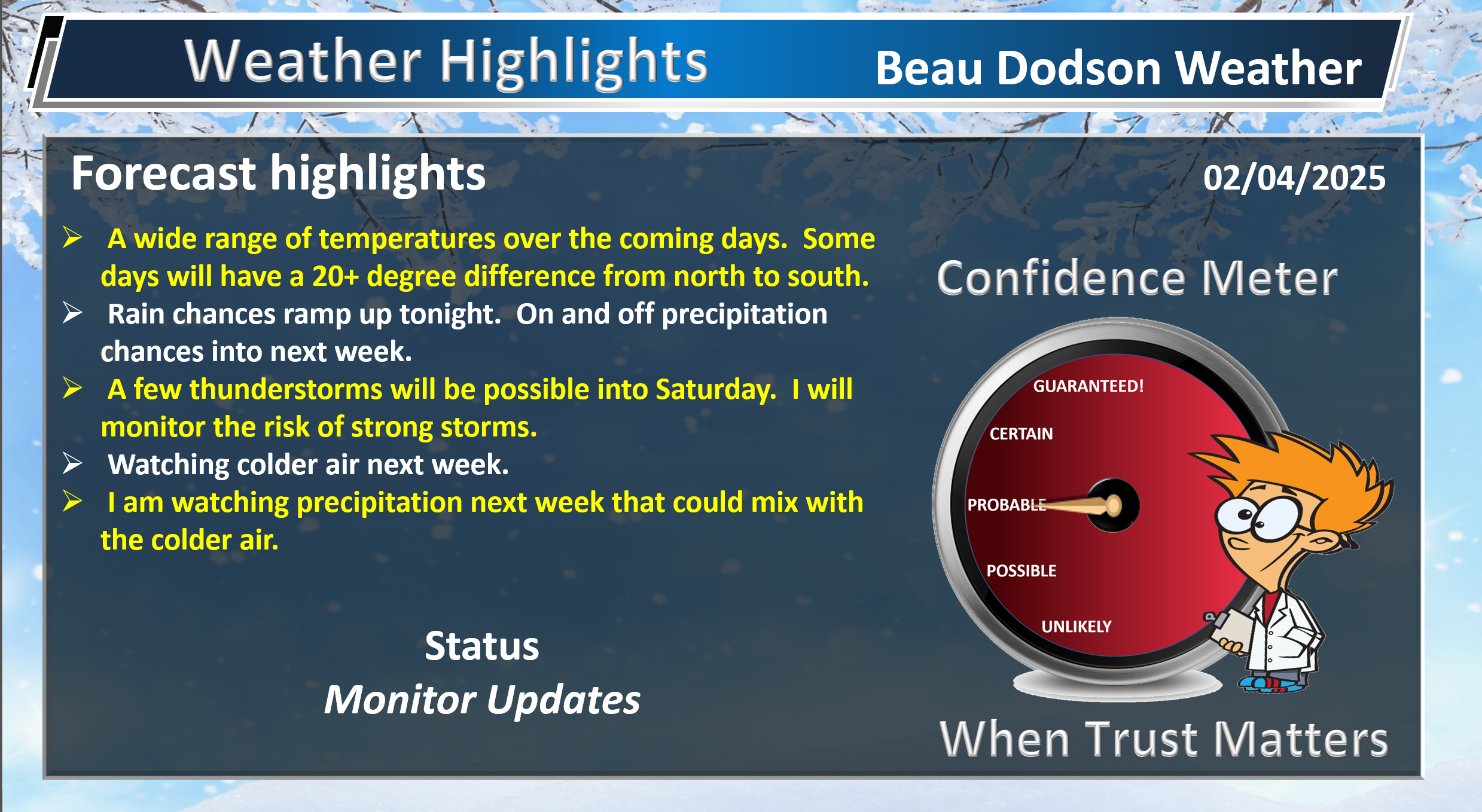
- Colder today. Breezy. Mix of sun and clouds.
- Rain chances ramp up tonight into Thursday. Another chances Friday night into Saturday night.
- Some thunderstorms are possible. I am monitoring the risk of a few severe thunderstorms Wednesday night. I will monitor Saturday, as well.
- Watching a couple of winter weather events next week. Still a bit early to know if it will impact our region.
.
Beau’s Forecast Discussion
Good day, everyone
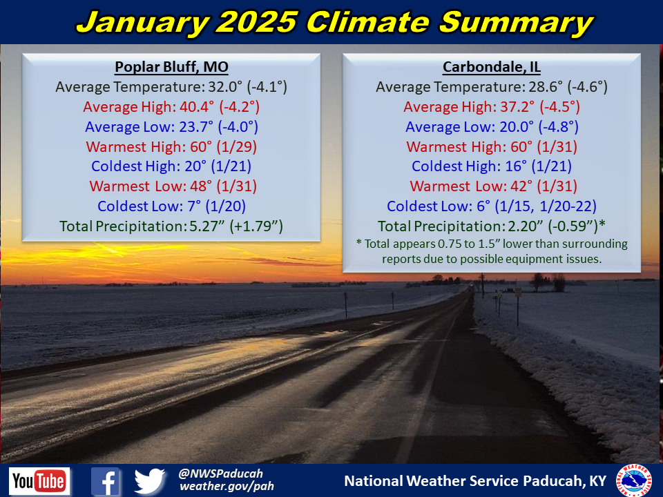
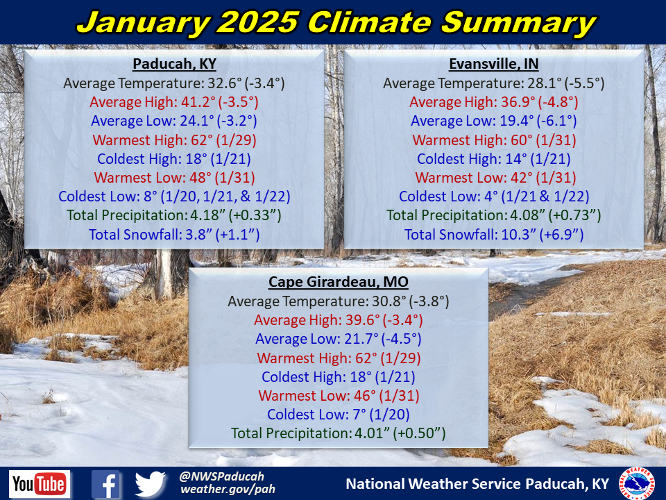
First, let’s look back at January’s stats.
Double click images to enlarge them.
——
Some locations recorded record high temperatures yesterday. Paducah was in the middle 70s! Record warmth. It sure did feel nice.
Here is what the Paducah, Kentucky, NWS posted
Paducah and Evansville have broken their record highs for today. So far Paducah is up to 73 and Evansville has reached 72 degrees. This is the warmest temperature this early in the season in Paducah since 1972! For Evansville it is the warmest temperature this early in the year since 1967.
We aren’t finished with mild temperatures, but we also have colder air in the long range forecast.
The temperature forecast, over the coming days, is complicated. Remember, I cover from Mt Vernon, Illinois into the Missouri Bootheel and northwest Tennessee.
There will be a wide range of temperatures over the coming days. The reason for that is a boundary that is draped across our region.
It will be colder north of the front. It will be warmer south of the front. There will be time periods that temperatures will be 20+ degrees cooler/warmer from north to south.
See those details at the top of the page in the area-forecast. I break it down from north to south.
We also have an active precipitation forecast. It won’t rain all of the time, but we do have high probabilities for on and off showers and thunderstorms.
If you have outdoor activities, then monitor the radars and forecast updates.
Today
We are waking up to cooler temperatures. The wind is making it feel colder.
Here were the 7 AM temperatures. Nothing extreme, but it feels cold outside.
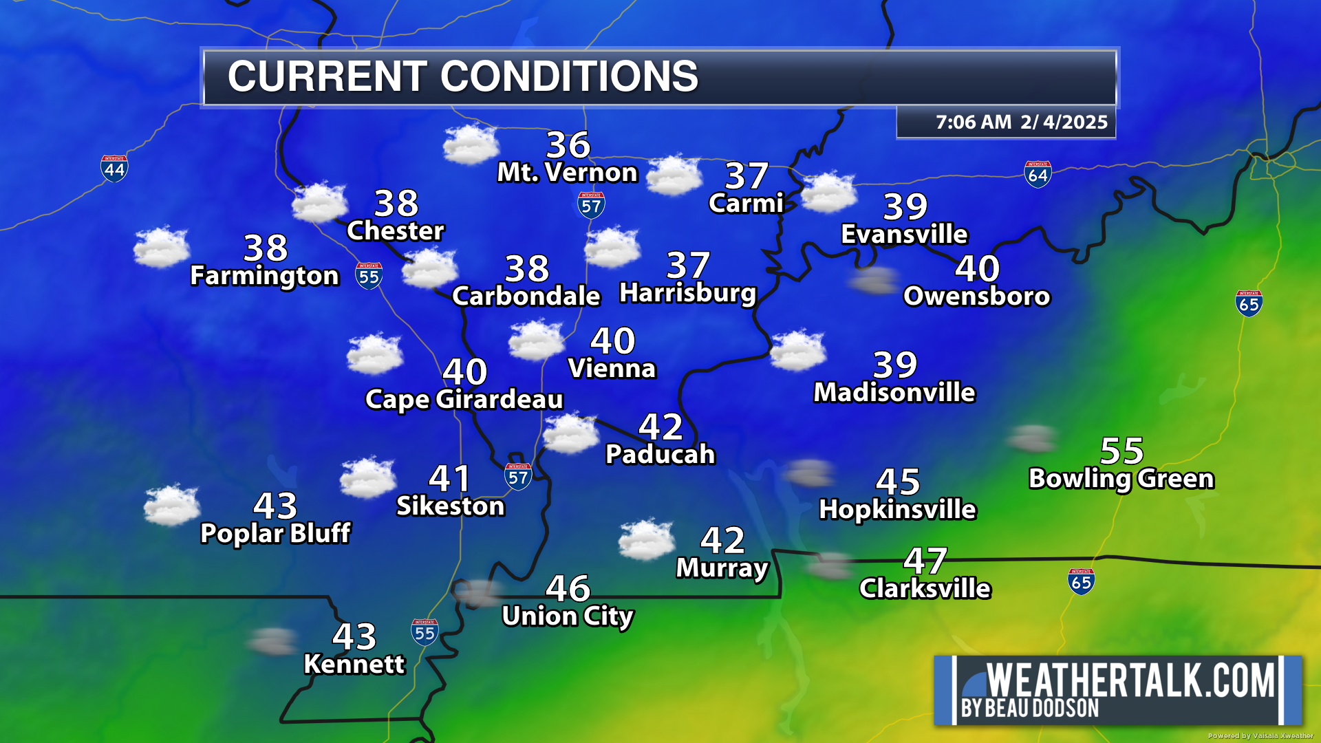
Dry today. No significant weather concerns.
It will be chilly today with gusty winds. A mix of sun and clouds. Clouds can be difficult to scour out during the winter months, so they may linger. This will make it feel cooler.
Here was the 7 AM satellite view. Lots of clouds.
Double click the image to enlarge it. You can just barely make out the state lines.
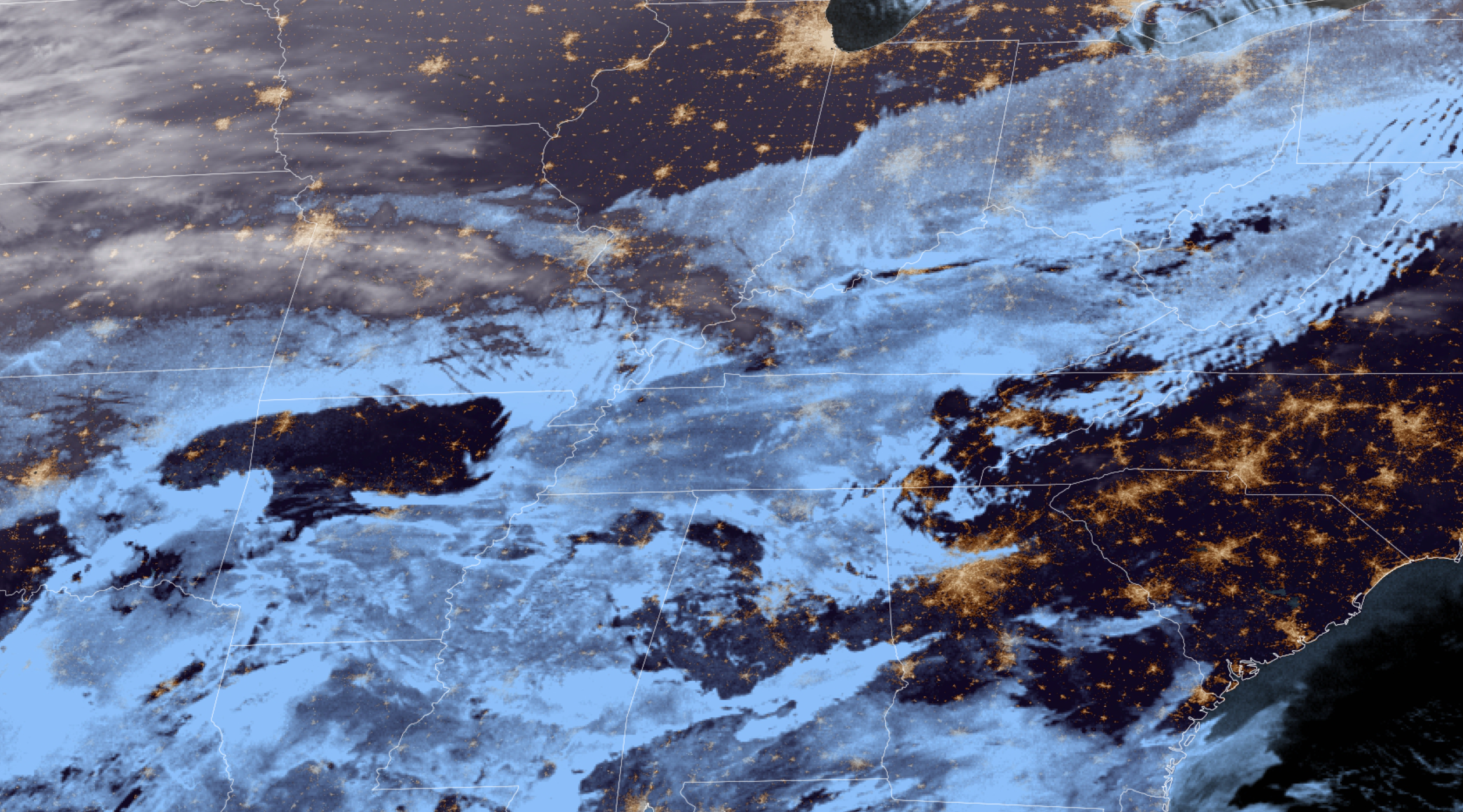
Again, it will be cool today in the temperature department. It will feel colder, since it was so warm yesterday.
Tonight into Thursday night
Rain chances will ramp up tonight. First arriving across southeast Missouri. Spreading northeast.
Rain chances will continue into Thursday. Occasionally, there will be thunderstorms, as well. It won’t rain all of the time. On and off precipitation.
I can’t rule out some small hail with the thunderstorms.
The Storm Prediction Center did pop a marginal level one severe weather risk for my far southeastern counties tomorrow afternoon and tomorrow night. This is mainly for tomorrow night (Wednesday night).
You can see the severe weather outlook here. Light green is sub-severe storms (lightning). Dark green is the low level one severe weather risk. The primary concern will be hail and wind. The tornado risk is limited. I will keep an eye on it.

Overall, the setup for severe weather is rather limited. There is a small window where instability will be a bit higher. That is why the SPC has outlined portions of the region for severe weather.
Shower and thunderstorm chances will continue into Thursday.
You can see that on the EC model lightning flash animation.
Time stamp is in Zulu. 00z=6 pm. 06z=12 am. 12z=6 am. 18z=12 pm.
A cold front will sweep across the region Thursday afternoon. This will bring an end to the shower and thunderstorm chances.
I have low-end rain chances Thursday night (mainly before midnight).
Friday into Sunday
Friday will likely be dry. No significant weather concerns during the day.
Another system moves into the region Friday night into Saturday night. This will bring additional showers and thunderstorms. I am monitoring the risk of strong storms on Saturday, but for now the Storm Prediction Center has held off on outlining a severe weather risk zone. I will keep an eye on it.
Either way, numerous showers and storms are likely as we move through Friday night and Saturday. Tapering off Saturday night/Sunday morning.
Perhaps a lingering shower on Sunday.
Saturday will be mild ahead of the cold front.
Colder air filters into the region Sunday and Monday. This sets the stage for next weeks weather.
Sunday highs
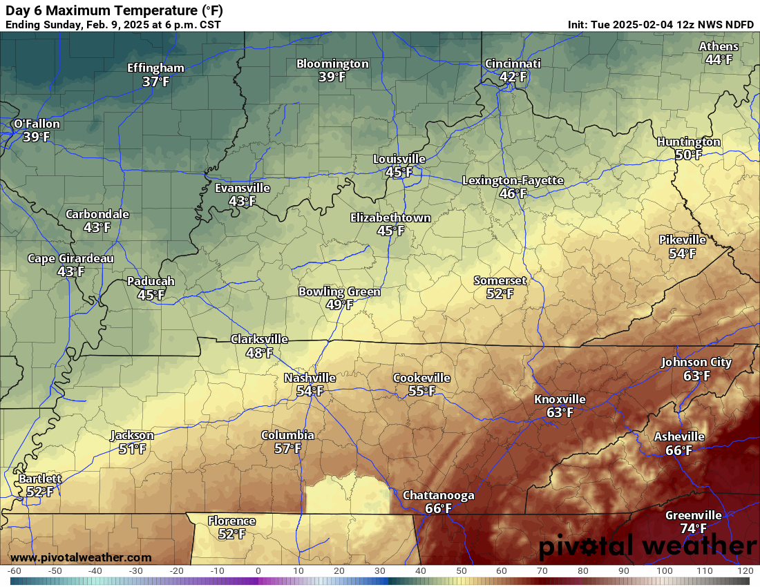
Monday highs
Future-cast Radars
Let’s look at the future-cast radar. This is the GFS model. Time-stamp upper left.
This takes us through Sunday. It covers the first two rain events.
Time stamp is in Zulu. 00z=6 pm. 06z=12 am. 12z=6 am. 18z=12 pm.
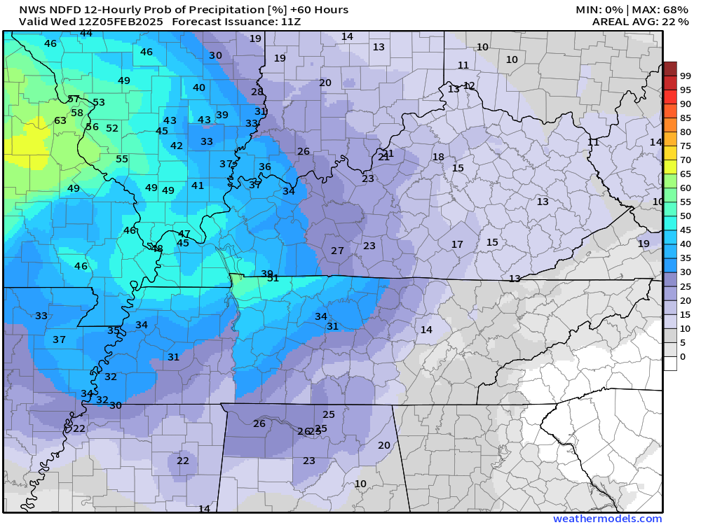
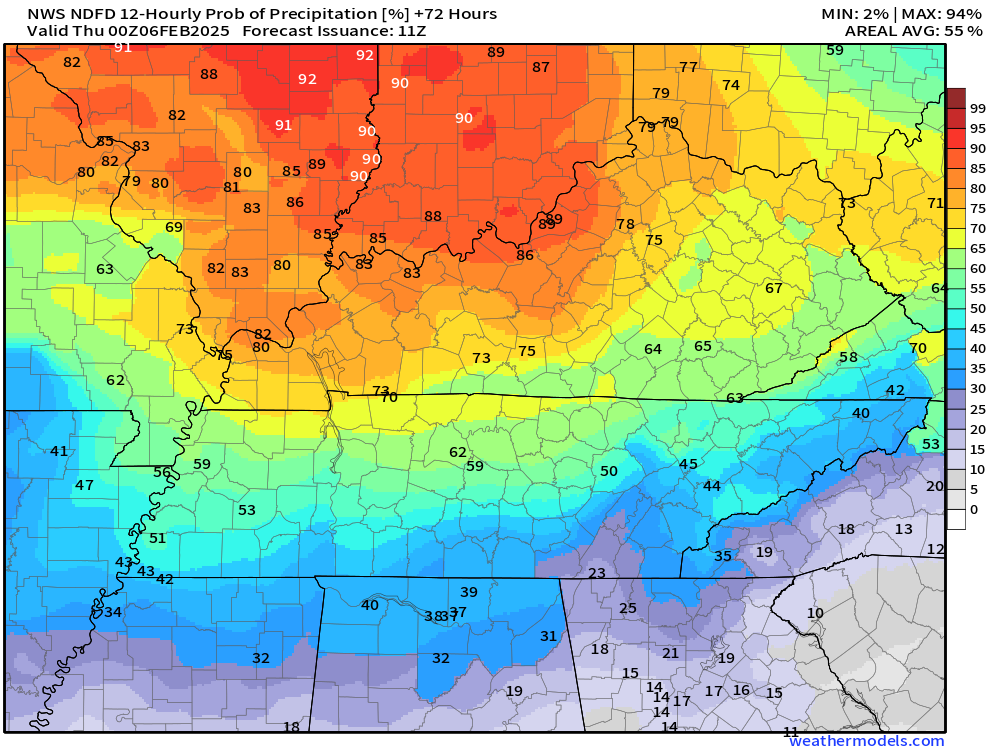
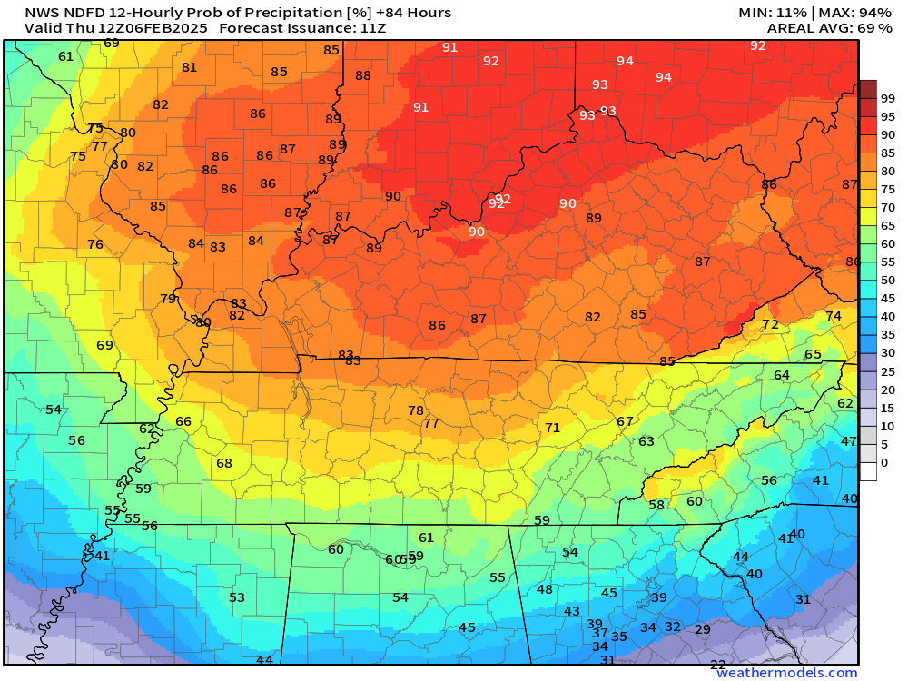
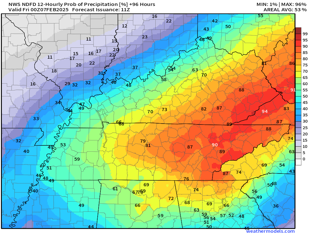
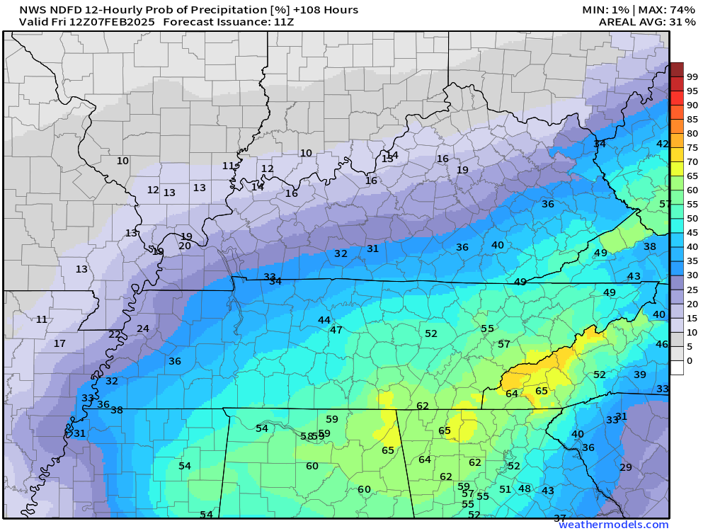
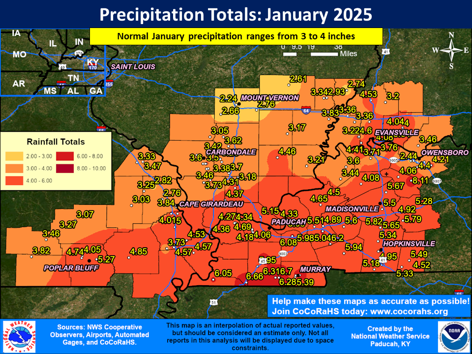
Let’s look at rainfall totals.
Here is the 72 hour rainfall outlook. This will cover the first event (tonight into Thursday night)
Double click images to enlarge them.
Now, let’s look at rainfall totals into Tuesday morning.
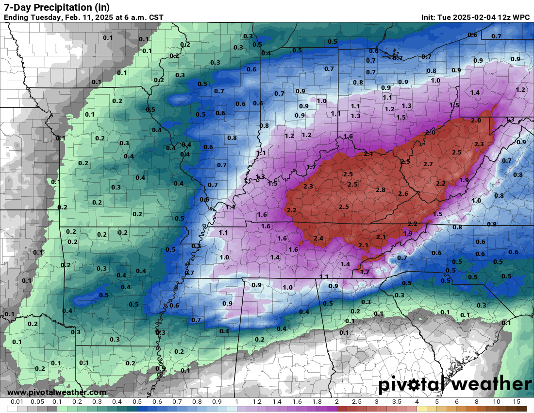
Not extreme. There could be enough rain to cause some field flooding. Some ditches could overflow. The risk of flooding is low.
This rain will be strung out over several days. That will help limit water issues. Thunderstorms can always enhance rainfall totals.
Next Week
A series of systems will track across the central and southern United States next week.
Yes, I have seen the crazy snowfall maps that are being passed around on social media.
It is too soon to know if our region will be dealing with snow, ice, or rain.
A lot of data shows plain old rain. Some data shows a series of wintry precipitation events.
It is possible that our region will have a wintry mix north and rain south.
With that said, it is just too soon to know.
Future-cast Radars
Let’s look at the GFS model future-cast radar for next week.
What do we take from this? We take the general idea that some precipitation is likely next week. We do not pay attention to precipitation type. It is just too soon to know that.
I do believe we see several rounds of precipitation.
Time stamp is in Zulu. 00z=6 pm. 06z=12 am. 12z=6 am. 18z=12 pm.
.
.![]()
.
Click here if you would like to return to the top of the page.
This outlook covers southeast Missouri, southern Illinois, western Kentucky, and far northwest Tennessee.

.
Today’s Storm Prediction Center’s (SPC) Severe Weather Outlook
Light green is where thunderstorms may occur but should be below severe levels.
Dark green is a level one risk. Yellow is a level two risk. Orange is a level three (enhanced) risk. Red is a level four (moderate) risk. Pink is a level five (high) risk.
One is the lowest risk. Five is the highest risk.
A severe storm is one that produces 58 mph wind or higher, quarter or larger size hail, and/or a tornado.
Explanation of tables. Click here.
Day One Severe Weather Outlook

Day One Severe Weather Outlook. Zoomed in on our region.

.
Day One Tornado Probability Outlook

Day One Regional Tornado Outlook. Zoomed in on our region.

.
Day One Large Hail Probability Outlook

Day One Regional Hail Outlook. Zoomed in on our region.

.
Day One High wind Probability Outlook

Day One Regional Wind Outlook. Zoomed in on our region.

.
Tomorrow’s severe weather outlook. Day two outlook.

Day Two Outlook. Zoomed in on our region.
.
Day Three Severe Weather Outlook

.
![]()
..![]()

.
Click here if you would like to return to the top of the page.
.Average high temperatures for this time of the year are around 44 degrees.
Average low temperatures for this time of the year are around 27 degrees.
Average precipitation during this time period ranges from 0.90″ to 1.20″
Six to Ten Day Outlook.
Blue is below average. Red is above average. The no color zone represents equal chances.
Average highs for this time of the year are in the lower 60s. Average lows for this time of the year are in the lower 40s.

Green is above average precipitation. Yellow and brown favors below average precipitation. Average precipitation for this time of the year is around one inch per week.

.

Average low temperatures for this time of the year are around 27 degrees.
Average precipitation during this time period ranges from 0.90″ to 1.20″
.
Eight to Fourteen Day Outlook.
Blue is below average. Red is above average. The no color zone represents equal chances.

Green is above average precipitation. Yellow and brown favors below average precipitation. Average precipitation for this time of the year is around one inch per week.

.
![]()
Make sure you have three to five ways of receiving your severe weather information.
Weather Talk is one of those ways! Now, I have another product for you and your family.

.
.
https://weathercallservices.com/beau-dodson-weather


Want to add more products to your Beau Dodson Weather App?
Receive daily videos, weather blog updates on normal weather days and severe weather and winter storm days, your county by county weather forecast, and more!
Here is how to do add those additional products to your app notification settings!
Here is a video on how to update your Beau Dodson Weather payment.
The app is for subscribers. Subscribe at www.weathertalk.com/welcome then go to your app store and search for WeatherTalk
Subscribers, PLEASE USE THE APP. ATT and Verizon are not reliable during severe weather. They are delaying text messages.
The app is under WeatherTalk in the app store.

Apple users click here

Android users click here
.

Radars and Lightning Data
Interactive-city-view radars. Clickable watches and warnings.
https://wtalk.co/B3XHASFZ
Old legacy radar site (some of you like it better)
https://weatherobservatory.com/weather-radar.htm
If the radar is not updating then try another one. If a radar does not appear to be refreshing then hit Ctrl F5. You may also try restarting your browser.
Backup radar site in case the above one is not working.
https://weathertalk.com/morani
Regional Radar
https://imagery.weathertalk.com/prx/RadarLoop.mp4
** NEW ** Zoom radar with chaser tracking abilities!
ZoomRadar
Lightning Data (zoom in and out of your local area)
https://wtalk.co/WJ3SN5UZ
Not working? Email me at beaudodson@usawx.com
National map of weather watches and warnings. Click here.
Storm Prediction Center. Click here.
Weather Prediction Center. Click here.
.

Live lightning data: Click here.
Real time lightning data (another one) https://map.blitzortung.org/#5.02/37.95/-86.99
Our new Zoom radar with storm chases
.
.

Interactive GOES R satellite. Track clouds. Click here.
GOES 16 slider tool. Click here.
College of DuPage satellites. Click here
.

Here are the latest local river stage forecast numbers Click Here.
Here are the latest lake stage forecast numbers for Kentucky Lake and Lake Barkley Click Here.
.
.
Find Beau on Facebook! Click the banner.


 .
.