We have a few sponsors that are helping cover new technology costs! Check them out.
Heating problems?
One Hour Heating and Air – Click Here

Connected and Protected.
They Specialize in Audio, Video, Networking, Security, Cameras, Electrical, New Construction, Remodels, and retrofitting Jobs. Experience the future of smart living and unmatched security with Connected & Protected Solutions today.
Link – Click here

Roof damage from recent storms? Link – Click here


Click one of the links below to take you directly to that section
![]()
![]()
![]()
![]()
![]()
.

.
Seven Day Hazardous Weather Outlook
1. Is lightning in the forecast? YES. Tuesday night into Thursday. I will monitor Friday and Saturday.
2. Are severe thunderstorms in the forecast? MONITOR. I am keeping an eye on Wednesday’s weather. Wednesday/Wednesday night. I am watching Saturday, as well.
3. Is flash flooding in the forecast? MONITOR. Some areas picked up two to four inches of rain over the past week. Any additional rainfall could cause issues. Especially, if we have thunderstorms this week. For now, the overall flood risk appears limited. I will closely monitor the mid and late week systems.
4. Will non-thunderstorm winds top 40 mph? NO.
6. Will the wind chill dip below 10 degrees? NOT AT THIS TIME.
7. Is measurable snow and/or sleet in the forecast? NOT AT THIS TIME.
8. Is freezing rain in the forecast? NOT AT THIS TIME.
.

.
The images below are from NOAA’s Weather Prediction Center.
24-hour precipitation outlook..
 .
.
.
48-hour precipitation outlook.
.
.
Field and Brush Fire weather risk level.
Sunday: 4. Low risk.
Sunday night: 4. Low risk.
Sunday: 4. Low risk.
Sunday night: 4. Low risk.
Fire Weather Discussion
Across southeast Missouri, poor dispersion is expected today with mixing heights near to below 2000 feet and minimum afternoon humidity of 45-60%. For areas east of the Mississippi River, dispersion will be fair with mixing heights of 2000-2600 feet and minimum afternoon humidity of 50-65%. On Monday, our entire region will see fair to poor dispersion with mixing heights of 1800-2300 feet and afternoon humidity of 55-65%. Good chances of rain and some thunderstorms arrive late Tuesday night and continue through Wednesday night into Thursday.
A Haines Index of 6 means a high potential for an existing fire to become large or exhibit erratic fire behavior, 5 means medium potential, 4 means low potential, and anything less than 4 means very low potential.
.

Notes:
THE FORECAST WILL TO VARY FROM LOCATION TO LOCATION.
Scroll down to see your local forecast details.
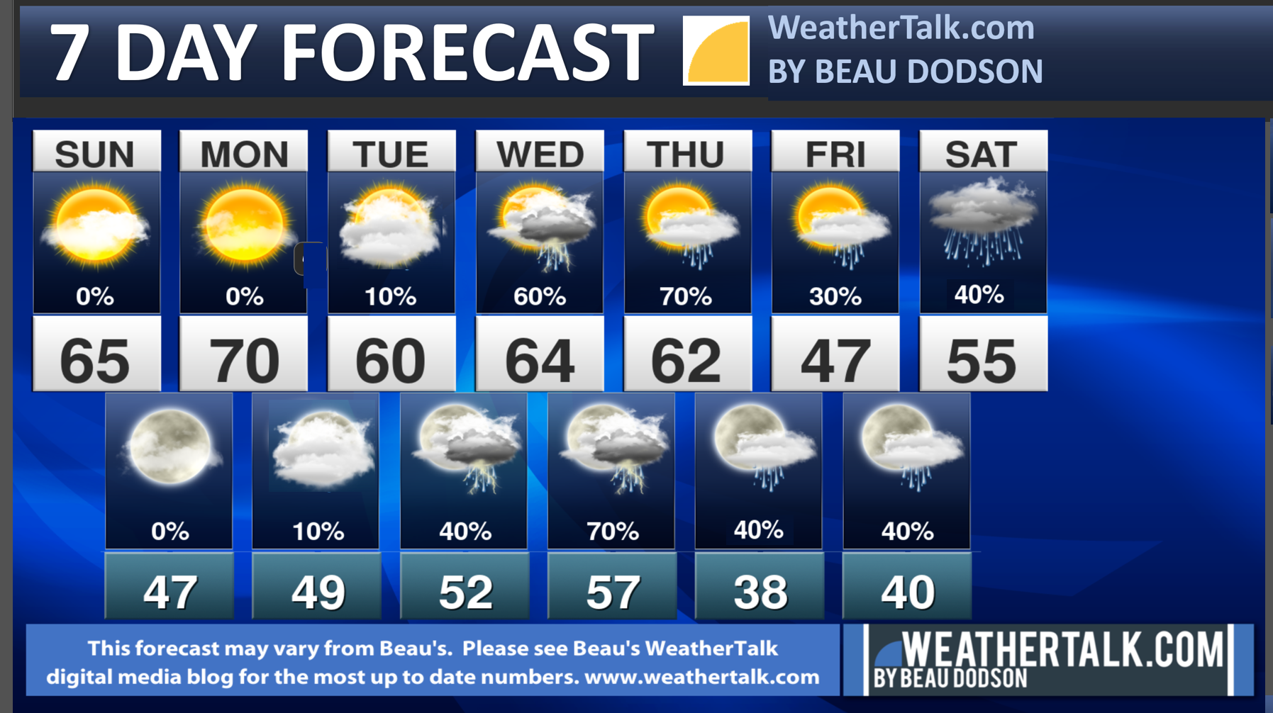
Seven-day forecast for southeast Missouri, southern Illinois, western Kentucky, and western Tennessee.
This is a BLEND for the region. Scroll further down to see the region by region forecast.
.
Beau’s Seven Day Video Outlook
.
A quick glance. 48-hour forecast Graphics


![]()
.
.
Sunday Forecast: Partly sunny.
What is the chance of precipitation?
Far northern southeast Missouri ~ 0%
Southeast Missouri ~ 0%
The Missouri Bootheel ~ 0%
I-64 Corridor of southern Illinois ~ 0%
Southern Illinois ~ 0%
Extreme southern Illinois (southern seven counties) ~ 0%
Far western Kentucky (Purchase area) ~ 0%
The Pennyrile area of western KY ~ 0%
Northwest Kentucky (near Indiana border) ~ 0%
Northwest Tennessee ~ 0%
Coverage of precipitation:
Timing of the precipitation:
Temperature range:
Far northern southeast Missouri 62° to 64°
Southeast Missouri 62° to 64°
The Missouri Bootheel 64° to 66°
I-64 Corridor of southern Illinois 60° to 62°
Southern Illinois 60° to 64°
Extreme southern Illinois (southern seven counties) 62° to 65°
Far western Kentucky 62° to 65°
The Pennyrile area of western KY 62° to 65°
Northwest Kentucky (near Indiana border) 60° to 65°
Northwest Tennessee 64° to 66°
Winds will be from this direction: Southwest at 10 to 20 mph. Gusty.
Wind chill or heat index (feels like) temperature forecast: 35° to 45° during the morning. In the 50s and 60s during the afternoon.
What impacts are anticipated from the weather?
Should I cancel my outdoor plans? No
UV Index: 3. Moderate
Sunrise: 6:57AM
Sunset: 5:22 PM
.
Sunday Night Forecast: Partly cloudy.
What is the chance of precipitation?
Far northern southeast Missouri ~ 0%
Southeast Missouri ~ 0%
The Missouri Bootheel ~ 0%
I-64 Corridor of southern Illinois ~ 0%
Southern Illinois ~ 0%
Extreme southern Illinois (southern seven counties) ~ 0%
Far western Kentucky (Purchase area) ~ 0%
The Pennyrile area of western KY ~ 0%
Northwest Kentucky (near Indiana border) ~ 0%
Northwest Tennessee ~ 0%
Coverage of precipitation:
Timing of the precipitation:
Temperature range:
Far northern southeast Missouri 44° to 48°
Southeast Missouri 44° to 48°
The Missouri Bootheel 44° to 48°
I-64 Corridor of southern Illinois 42° to 44°
Southern Illinois 42° to 45°
Extreme southern Illinois (southern seven counties) 44° to 48°
Far western Kentucky 46° to 48°
The Pennyrile area of western KY 46° to 48°
Northwest Kentucky (near Indiana border) 46° to 48°
Northwest Tennessee 46° to 48°
Winds will be from this direction: South southwest at 6 to 12 mph.
Wind chill or heat index (feels like) temperature forecast: 38° to 44°
What impacts are anticipated from the weather?
Should I cancel my outdoor plans? No
Moonrise: 9:21 AM
Moonset: 10:22 PM
The phase of the moon: Waxing Crescent
.
Monday Forecast: Partly sunny.
What is the chance of precipitation?
Far northern southeast Missouri ~ 0%
Southeast Missouri ~ 0%
The Missouri Bootheel ~ 0%
I-64 Corridor of southern Illinois ~ 0%
Southern Illinois ~ 0%
Extreme southern Illinois (southern seven counties) ~ 0%
Far western Kentucky (Purchase area) ~ 0%
The Pennyrile area of western KY ~ 0%
Northwest Kentucky (near Indiana border) ~ 0%
Northwest Tennessee ~ 0%
Coverage of precipitation:
Timing of the precipitation:
Temperature range:
Far northern southeast Missouri: 65° to 70°
Southeast Missouri: 66° to 70°
The Missouri Bootheel: 68° to 70°
I-64 Corridor of southern Illinois: 65° to 70°
Southern Illinois: 66° to 70°
Extreme southern Illinois (southern seven counties): 66° to 70°
Far western Kentucky: 66° to 70°
The Pennyrile area of western Kentucky: 66° to 70°
Northwest Kentucky (near Indiana border): 65° to 70°
Northwest Tennessee: 68° to 70°
Winds will be from this direction: South southwest at 10 to 20 mph. Gusty.
Wind chill or heat index (feels like) temperature forecast: 40° to 45° during the morning. In the 60s during the afternoon.
What impacts are anticipated from the weather?
Should I cancel my outdoor plans? No
UV Index: 2. Low
Sunrise: 6:56 AM
Sunset: 5:23 PM
.
Monday Night Forecast: Partly cloudy.
What is the chance of precipitation?
Far northern southeast Missouri ~ 0%
Southeast Missouri ~ 0%
The Missouri Bootheel ~ 0%
I-64 Corridor of southern Illinois ~ 0%
Southern Illinois ~ 0%
Extreme southern Illinois (southern seven counties) ~ 0%
Far western Kentucky (Purchase area) ~ 0%
The Pennyrile area of western KY ~ 0%
Northwest Kentucky (near Indiana border) ~ 0%
Northwest Tennessee ~ 0%
Coverage of precipitation:
Timing of the precipitation:
Temperature range:
Far northern southeast Missouri: 38° to 42°
Southeast Missouri: 42° to 45°
The Missouri Bootheel: 46° to 50°
I-64 Corridor of southern Illinois: 36° to 38°
Southern Illinois: 38° to 42°
Extreme southern Illinois (southern seven counties): 44° to 46°
Far western Kentucky (Purchase area): 44° to 46°
The Pennyrile area of western Kentucky: 46° to 48°
Northwest Kentucky (near Indiana border): 42° to 45°
Northwest Tennessee: 46° to 48°
Winds will be from this direction: South southwest becoming north northwest at 6 to 12 mph.
Wind chill or heat index (feels like) temperature forecast: 36° to 46°
What impacts are anticipated from the weather?
Should I cancel my outdoor plans? No
Moonrise: 9:48 AM
Moonset: 11:34 PM
The phase of the moon: Waxing Crescent
.
Tuesday Forecast: Increasing clouds. A slight chance of light showers after 4 PM over southeast Missouri.
What is the chance of precipitation?
Far northern southeast Missouri ~ 10%
Southeast Missouri ~ 20%
The Missouri Bootheel ~ 20%
I-64 Corridor of southern Illinois ~ 0%
Southern Illinois ~ 0%
Extreme southern Illinois (southern seven counties) ~ 0%
Far western Kentucky (Purchase area) ~ 0%
The Pennyrile area of western KY ~ 0%
Northwest Kentucky (near Indiana border) ~ 0%
Northwest Tennessee ~ 10%
Coverage of precipitation: Isolated
Timing of the precipitation: After 4 pm.
Temperature range:
Far northern southeast Missouri: 54° to 56°
Southeast Missouri: 54° to 58°
The Missouri Bootheel: 60° to 65°
I-64 Corridor of southern Illinois: 50° to 52°
Southern Illinois: 52° to 55°
Extreme southern Illinois (southern seven counties): 56° to 58°
Far western Kentucky: 60° to 64°
The Pennyrile area of western Kentucky: 62° to 64°
Northwest Kentucky (near Indiana border): 58° to 62°
Northwest Tennessee: 64° to 66°
Winds will be from this direction: North northeast at 7 to 14 mph. Higher gusts possible.
Wind chill or heat index (feels like) temperature forecast: 38° to 44° during the morning. In the 50s and 60s during the afternoon.
What impacts are anticipated from the weather? Isolated wet roadways.
Should I cancel my outdoor plans? No
UV Index: 2. Low.
Sunrise: 6:55 AM
Sunset: 5:24 PM
.
Tuesday Night Forecast: Mostly cloudy. A chance of showers. A thunderstorm will be possible.
What is the chance of precipitation?
Far northern southeast Missouri ~ 40%
Southeast Missouri ~ 40%
The Missouri Bootheel ~ 40%
I-64 Corridor of southern Illinois ~ 40%
Southern Illinois ~ 40%
Extreme southern Illinois (southern seven counties) ~ 40%
Far western Kentucky (Purchase area) ~ 40%
The Pennyrile area of western KY ~ 40%
Northwest Kentucky (near Indiana border) ~ 40%
Northwest Tennessee ~ 40%
Coverage of precipitation: Scattered
Timing of the precipitation: Any given point of time.
Temperature range:
Far northern southeast Missouri: 42° to 44°
Southeast Missouri: 42° to 45°
The Missouri Bootheel: 48° to 52°
I-64 Corridor of southern Illinois: 38° to 42°
Southern Illinois: 40° to 45°
Extreme southern Illinois (southern seven counties): 46° to 50°
Far western Kentucky (Purchase area): 46° to 50°
The Pennyrile area of western Kentucky: 46° to 50°
Northwest Kentucky (near Indiana border): 46° to 48°
Northwest Tennessee: 50° to 52°
Winds will be from this direction: East southeast at 6 to 12 mph
Wind chill or heat index (feels like) temperature forecast: 38° to 50°
What impacts are anticipated from the weather? Wet roadways. Lightning.
Should I cancel my outdoor plans? No, but monitor the Beau Dodson Weather Radars.
Moonrise: 10:17 AM
Moonset:
The phase of the moon: First Quarter
.
Wednesday Forecast: Mostly cloudy. Showers and thunderstorms likely.
What is the chance of precipitation?
Far northern southeast Missouri ~ 60%
Southeast Missouri ~ 60%
The Missouri Bootheel ~ 60%
I-64 Corridor of southern Illinois ~ 60%
Southern Illinois ~ 70%
Extreme southern Illinois (southern seven counties) ~ 70%
Far western Kentucky (Purchase area) ~ 60%
The Pennyrile area of western KY ~ 60%
Northwest Kentucky (near Indiana border) ~ 70%
Northwest Tennessee ~ 60%
Coverage of precipitation: Numerous
Timing of the precipitation: Any given point of time.
Temperature range:
Far northern southeast Missouri: 60° to 62°
Southeast Missouri: 62° to 64°
The Missouri Bootheel: 68° to 70°
I-64 Corridor of southern Illinois: 58° to 60°
Southern Illinois: 60° to 64°
Extreme southern Illinois (southern seven counties): 62° to 65°
Far western Kentucky: 62° to 65°
The Pennyrile area of western Kentucky: 66° to 70°
Northwest Kentucky (near Indiana border): 60° to 62°
Northwest Tennessee: 65° to 70°
Winds will be from this direction: Southwest at 10 to 20 mph. Gusty.
Wind chill or heat index (feels like) temperature forecast: 40° to 48° during the morning. In the 50s and 60s during the afternoon.
What impacts are anticipated from the weather? Wet roadways. Lightning. Monitor the risk of intense thunderstorms.
Should I cancel my outdoor plans? Have a plan B. Monitor updates. Monitor the Beau Dodson Weather Radars.
UV Index: 2. Low.
Sunrise: 6:54 AM
Sunset: 5:26 PM
.
Wednesday Night Forecast: Mostly cloudy. A chance of showers and thunderstorms.
What is the chance of precipitation?
Far northern southeast Missouri ~ 70%
Southeast Missouri ~ 70%
The Missouri Bootheel ~ 70%
I-64 Corridor of southern Illinois ~ 70%
Southern Illinois ~ 70%
Extreme southern Illinois (southern seven counties) ~ 70%
Far western Kentucky (Purchase area) ~ 70%
The Pennyrile area of western KY ~ 70%
Northwest Kentucky (near Indiana border) ~ 70%
Northwest Tennessee ~ 70%
Coverage of precipitation: Numerous
Timing of the precipitation: Any given point of time.
Temperature range:
Far northern southeast Missouri: 42° to 44°
Southeast Missouri: 46° to 50°
The Missouri Bootheel: 54° to 56°
I-64 Corridor of southern Illinois: 40° to 42°
Southern Illinois: 42° to 45°
Extreme southern Illinois (southern seven counties): 46° to 50°
Far western Kentucky (Purchase area): 48° to 50°
The Pennyrile area of western Kentucky: 48° to 50°
Northwest Kentucky (near Indiana border): 46° to 50°
Northwest Tennessee: 48° to 52°
Winds will be from this direction: South southwest at 10 to 20 mph. Gusty.
Wind chill or heat index (feels like) temperature forecast: 36° to 48°
What impacts are anticipated from the weather? Wet roadways. Lightning. Monitor the risk of intense thunderstorms.
Should I cancel my outdoor plans? Have a plan B. Monitor updates. Monitor the Beau Dodson Weather Radars.
Moonrise: 10:52 AM
Moonset: 12:47 AM
The phase of the moon: Waxing Gibbous
.
Thursday Forecast: Intervals of clouds. A chance of showers and thunderstorms.
What is the chance of precipitation?
Far northern southeast Missouri ~ 30%
Southeast Missouri ~ 40%
The Missouri Bootheel ~ 40%
I-64 Corridor of southern Illinois ~ 40%
Southern Illinois ~ 60%
Extreme southern Illinois (southern seven counties) ~ 70%
Far western Kentucky (Purchase area) ~ 60%
The Pennyrile area of western KY ~ 70%
Northwest Kentucky (near Indiana border) ~ 70%
Northwest Tennessee ~ 60%
Coverage of precipitation: Scattered
Timing of the precipitation: Any given point of time.
Temperature range:
Far northern southeast Missouri: 53° to 56°
Southeast Missouri: 54° to 58°
The Missouri Bootheel: 60° to 62°
I-64 Corridor of southern Illinois: 52° to 58°
Southern Illinois: 52° to 55°
Extreme southern Illinois (southern seven counties): 56° to 58°
Far western Kentucky: 60° to 64°
The Pennyrile area of western Kentucky: 64° to 66°
Northwest Kentucky (near Indiana border): 58° to 62°
Northwest Tennessee: 62° to 64°
Winds will be from this direction: North northwest at 10 to 20 mph.
Wind chill or heat index (feels like) temperature forecast: 38° to 48° during the morning. In the 50s and 60s during the afternoon.
What impacts are anticipated from the weather? Wet roadways. Lightning.
Should I cancel my outdoor plans? Have a plan B. Monitor updates. Monitor the Beau Dodson Weather Radars.
UV Index: 3. Moderate
Sunrise: 6:53 AM
Sunset: 5:26 PM
.
Thursday Night Forecast: Mostly cloudy. A chance of showers.
What is the chance of precipitation?
Far northern southeast Missouri ~ 20%
Southeast Missouri ~ 20%
The Missouri Bootheel ~ 20%
I-64 Corridor of southern Illinois ~ 20%
Southern Illinois ~ 30%
Extreme southern Illinois (southern seven counties) ~ 30%
Far western Kentucky (Purchase area) ~ 40%
The Pennyrile area of western KY ~ 40%
Northwest Kentucky (near Indiana border) ~ 40%
Northwest Tennessee ~ 40%
Coverage of precipitation: Scattered
Timing of the precipitation: Mainly before 12 AM
Temperature range:
Far northern southeast Missouri: 26° to 30°
Southeast Missouri: 30° to 35°
The Missouri Bootheel: 35° to 40°
I-64 Corridor of southern Illinois: 26° to 30°
Southern Illinois: 30° to 32°
Extreme southern Illinois (southern seven counties): 32° to 34°
Far western Kentucky (Purchase area): 34° to 38°
The Pennyrile area of western Kentucky: 34° to 38°
Northwest Kentucky (near Indiana border): 32° to 35°
Northwest Tennessee: 36° to 40°
Winds will be from this direction: North at 7 to 14 mph.
Wind chill or heat index (feels like) temperature forecast: 22° to 32°
What impacts are anticipated from the weather?
Should I cancel my outdoor plans? No
Moonrise: 11:34 AM
Moonset: 2:00 AM
The phase of the moon: Waxing Gibbous
.
Friday Forecast: Partly sunny. A slight chance of a shower. It’s possible Friday ends up dry.
What is the chance of precipitation?
Far northern southeast Missouri ~ 20%
Southeast Missouri ~20%
The Missouri Bootheel ~ 20%
I-64 Corridor of southern Illinois ~ 20%
Southern Illinois ~ 20%
Extreme southern Illinois (southern seven counties) ~ 30%
Far western Kentucky (Purchase area) ~ 30%
The Pennyrile area of western KY ~ 30%
Northwest Kentucky (near Indiana border) ~ 20%
Northwest Tennessee ~ 20%
Coverage of precipitation: Isolated
Timing of the precipitation: Any given point of time.
Temperature range:
Far northern southeast Missouri: 46° to 48°
Southeast Missouri: 48° to 50°
The Missouri Bootheel: 50° to 52°
I-64 Corridor of southern Illinois: 48° to 52°
Southern Illinois: 48° to 52°
Extreme southern Illinois (southern seven counties): 52° to 54°
Far western Kentucky: 52° to 54°
The Pennyrile area of western Kentucky: 52° to 55°
Northwest Kentucky (near Indiana border): 48° to 52°
Northwest Tennessee: 52° to 55°
Winds will be from this direction: Northeast at 7 to 14 mph.
Wind chill or heat index (feels like) temperature forecast: 24° to 34° during the morning. In the 50s during the afternoon.
What impacts are anticipated from the weather? Isolated wet roadways. It may end up dry on Friday.
Should I cancel my outdoor plans? No
UV Index: 3. Moderate
Sunrise: 6:52 AM
Sunset: 5:27 PM
.
Friday Night Forecast: Increasing clouds. A chance of showers. Chilly.
What is the chance of precipitation?
Far northern southeast Missouri ~ 40%
Southeast Missouri ~ 40%
The Missouri Bootheel ~ 40%
I-64 Corridor of southern Illinois ~ 40%
Southern Illinois ~ 40%
Extreme southern Illinois (southern seven counties) ~ 40%
Far western Kentucky (Purchase area) ~ 40%
The Pennyrile area of western KY ~ 40%
Northwest Kentucky (near Indiana border) ~ 30%
Northwest Tennessee ~ 40%
Coverage of precipitation: Scattered
Timing of the precipitation: Any given point of time.
Temperature range:
Far northern southeast Missouri: 34° to 38°
Southeast Missouri: 38° to 42°
The Missouri Bootheel: 40° to 44°
I-64 Corridor of southern Illinois: 33° to 36°
Southern Illinois: 36° to 38°
Extreme southern Illinois (southern seven counties): 38° to 40°
Far western Kentucky (Purchase area): 40° to 44°
The Pennyrile area of western Kentucky: 40° to 44°
Northwest Kentucky (near Indiana border): 40° to 44°
Northwest Tennessee: 42° to 44°
Winds will be from this direction: East at 5 to 10 mph.
Wind chill or heat index (feels like) temperature forecast: 32° to 44°
What impacts are anticipated from the weather? Wet roadways.
Should I cancel my outdoor plans? No, but monitor updates.
Moonrise: 12:24 PM
Moonset: 3:11 AM
The phase of the moon: Waxing Gibbous
.
Click here if you would like to return to the top of the page.

Do you have any suggestions or comments? Email me at beaudodson@usawx.com
.
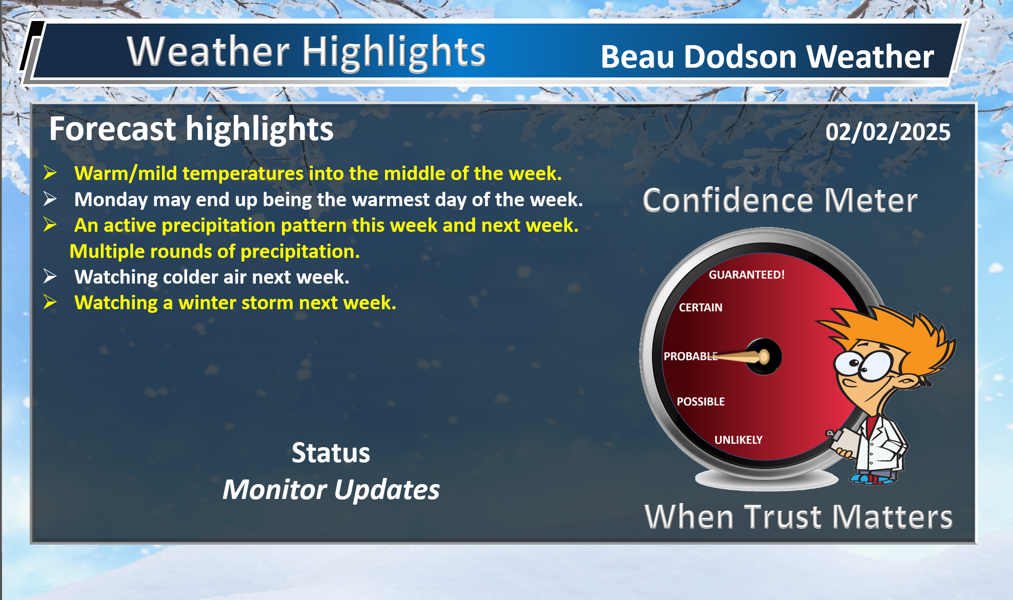
Weather Highlights and Forecast Discussion
-
- Nice today and tomorrow.
- Monday may end up being the warmest day of the week.
- Monitoring rain chances Tuesday into the weekend. On and off showers and thunderstorms.
- Monitoring the risk of severe thunderstorms mid-week.
- Watching a winter storm next week.
.
Beau’s Forecast Discussion
Changeable forecasts are likely over the next two weeks. We will just have to take each system one at a time.
You will want to monitor the most up to date forecast.
We have a wide range of weather over the coming two weeks. That includes rain, thunderstorms, snow, and ice.
Confidence in the forecast past day five is going to be lower.
An Arctic frontal boundary will cause problems for our region.
Cold to the north. Warm to the south.
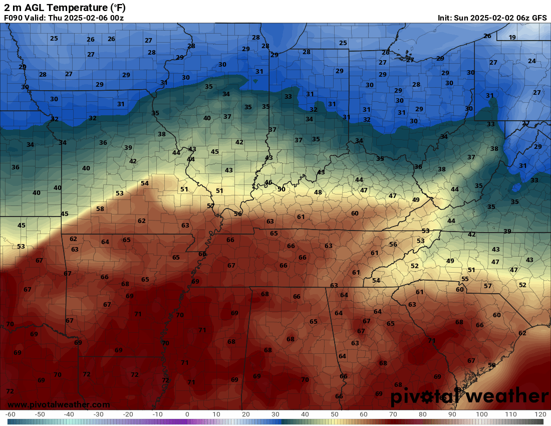
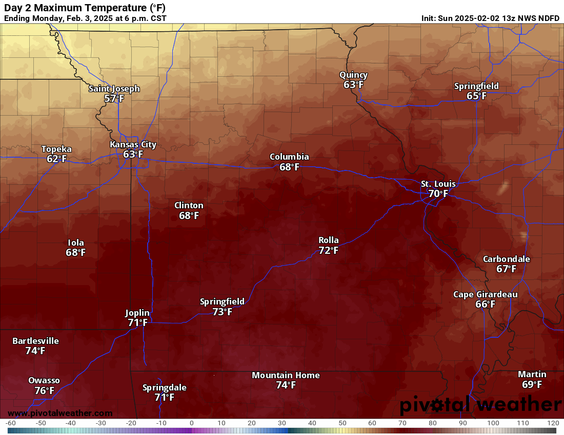
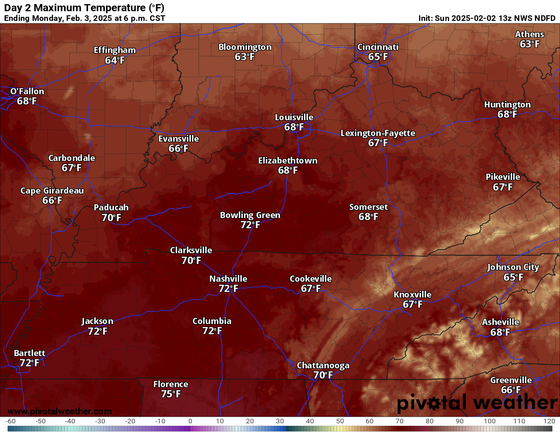
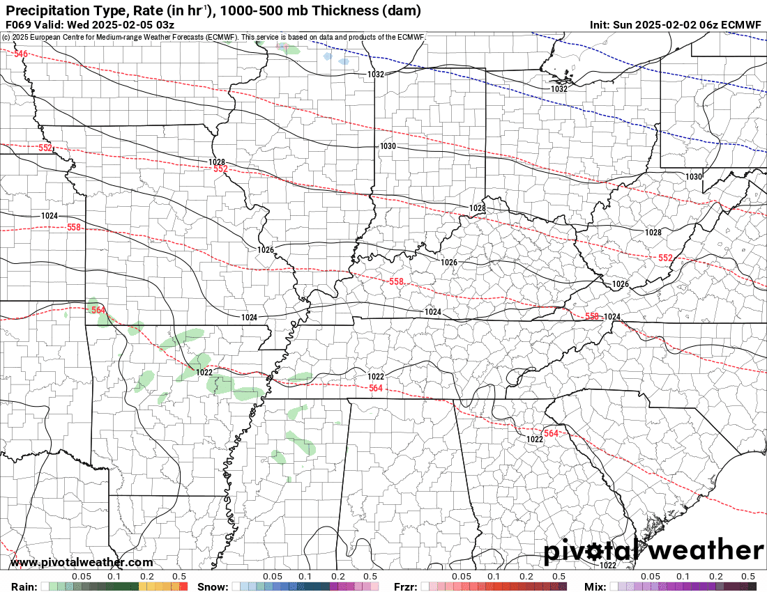
For example, here is the temperature forecast for this Wednesday evening. At one time, we were thinking Wednesday might be the warmest day of the week. Now, we believe tomorrow will be.
You can see the cold air to the north. Warm air to the south. The exact placement of that frontal boundary will be key to whether we see plain old rain or thunderstorms (some intense).
If the warm sector pushes farther north, then severe storms could be an issue Wednesday afternoon and especially Wednesday night. Double click images to enlarge them.
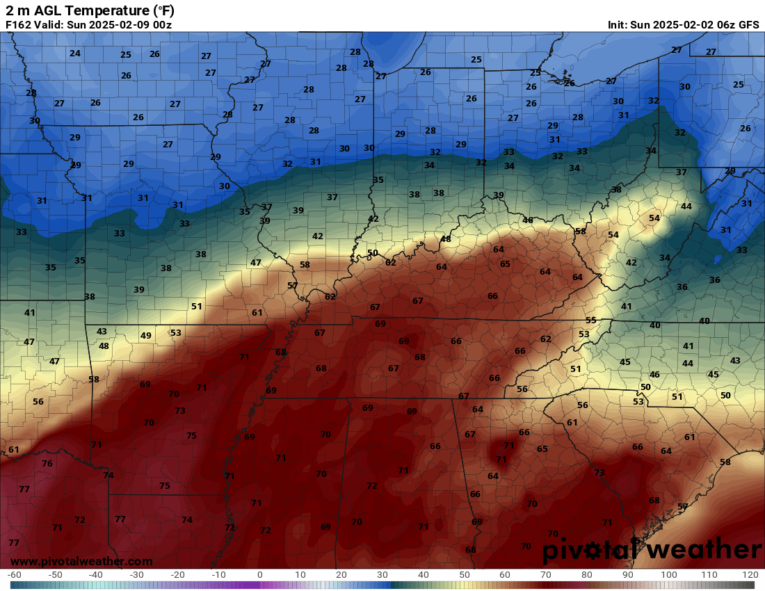
Check out next Saturday’s temperature forecast.
Once again, cold to the north. Warm to the south. That frontal boundary will be key to our weather.
Here is the forecast for tomorrow.
Warm! Near record highs in some counties.
Monday may be the warmest day of the week. Double click images to enlarge them.
A wet pattern.
Multiple rounds of precipitation are likely to occur in the battle zone between the cold air and warm air.
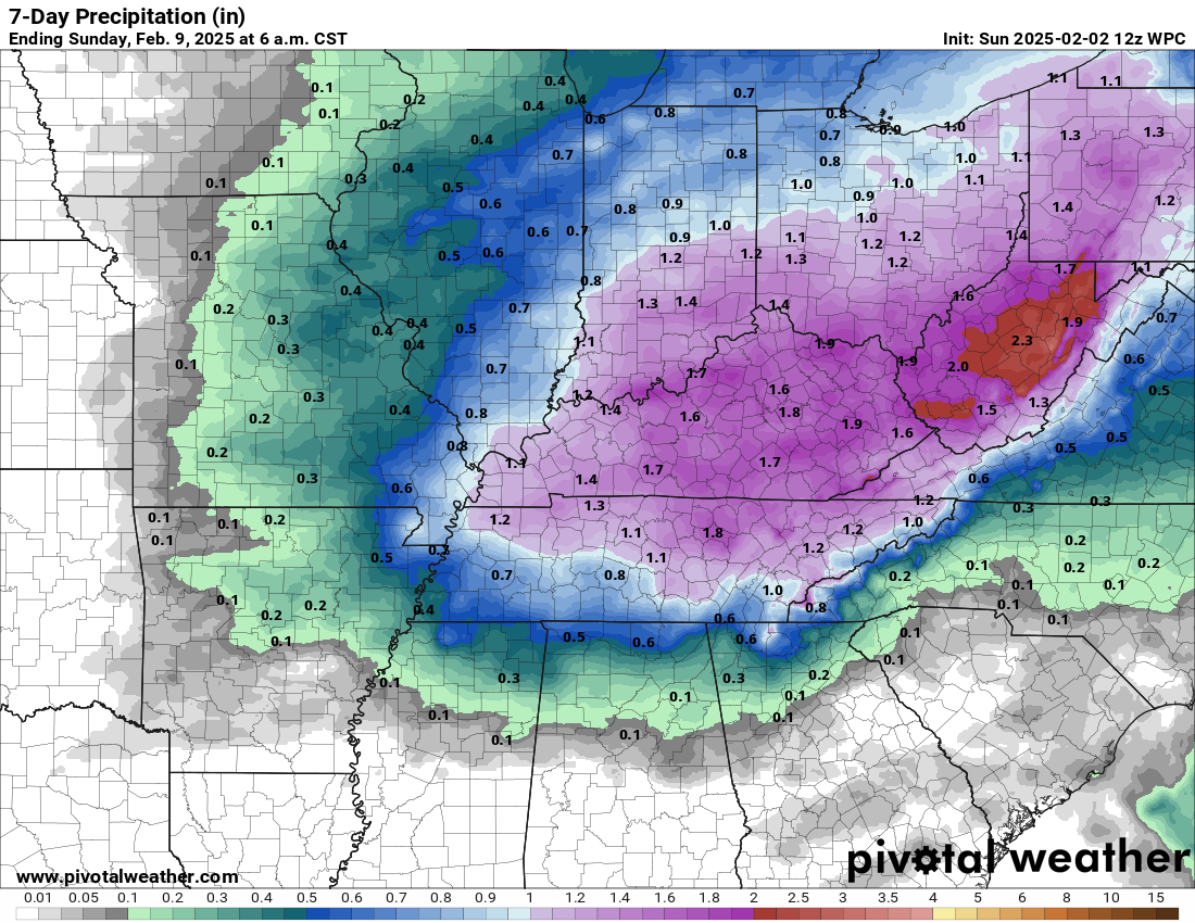
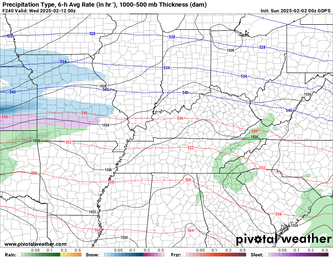
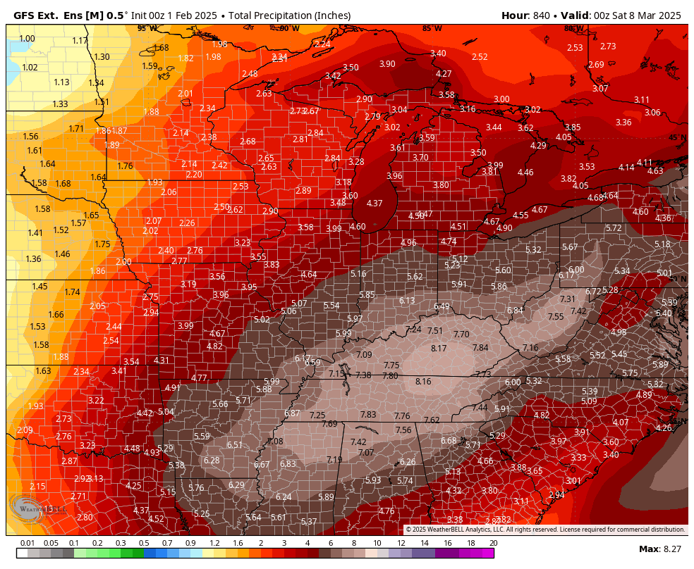
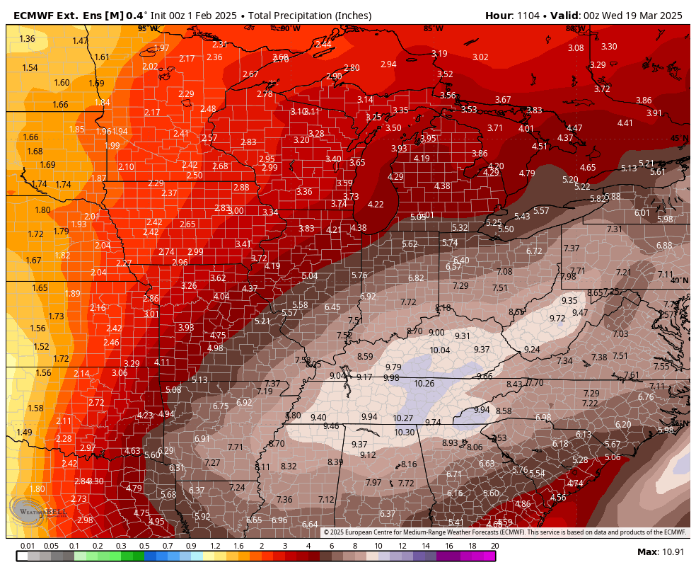
Here is the latest seven day rainfall outlook. These numbers have increased a bit.
Double click images to enlarge them.
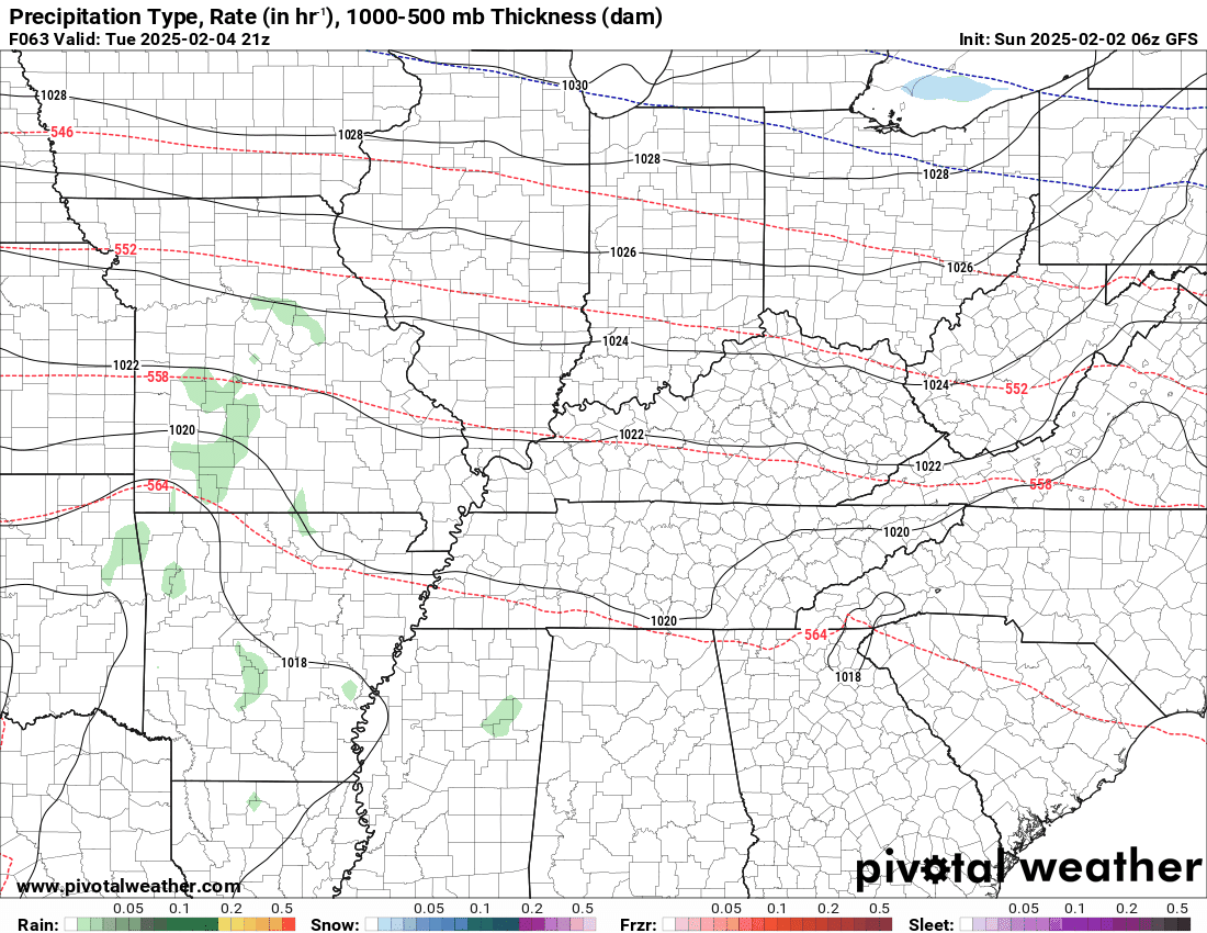
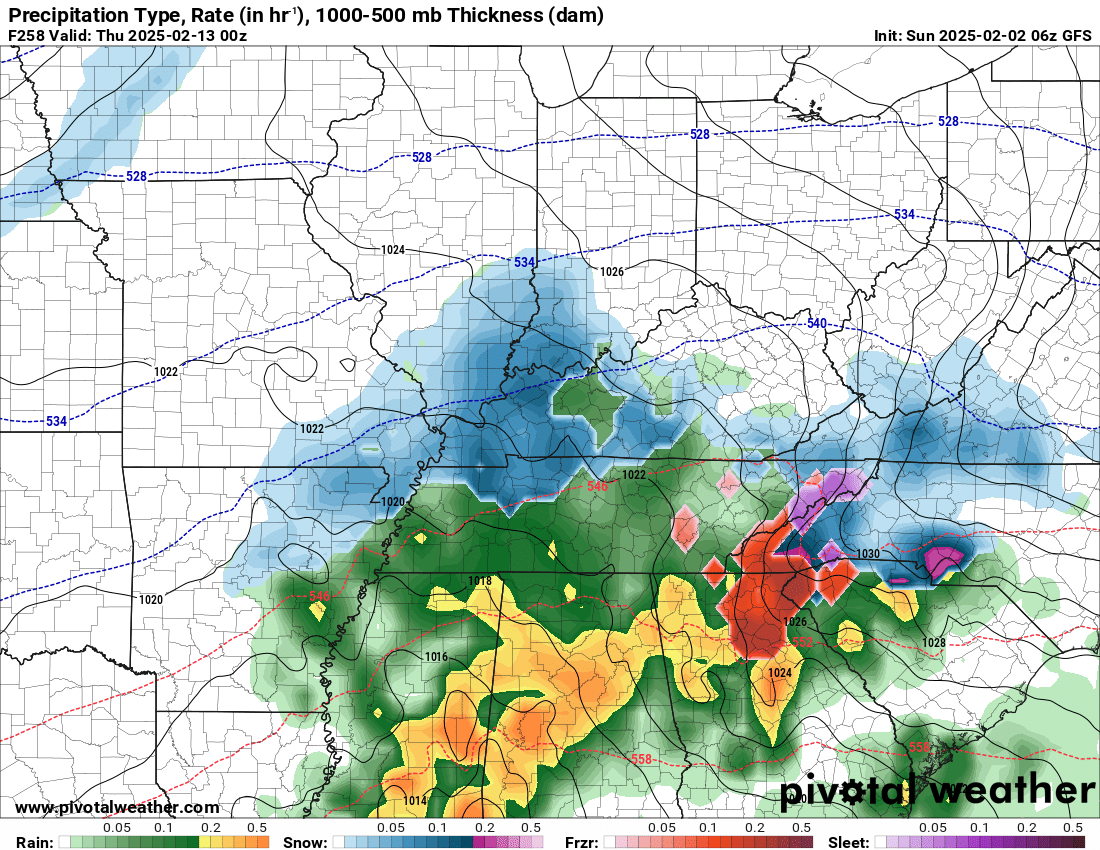
You can see the showers and thunderstorms on these future-cast radars. I am tracking no less than five precipitation events over the next fourteen days.
The GFS model takes us through Saturday. You can see, several rounds of rain. Thunderstorms, as well.
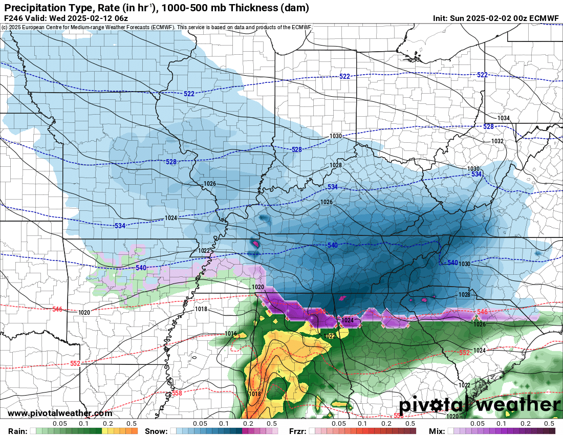
The second animation is the EC model. It also shows several rounds of rain. Thunderstorms, as well.
Let’s Look At The Future-cast Radar
This shows you what radar might look like.
GFS model
Time stamp is in Zulu. 00z=6 pm. 06z=12 am. 12z=6 am. 18z=12 pm.
.
EC model
Time stamp is in Zulu. 00z=6 pm. 06z=12 am. 12z=6 am. 18z=12 pm.
For now, the Storm Prediction Center has held off on issuing a marginal or slight risk of severe thunderstorms Wednesday into Wednesday night.
They have left open the idea that they could outline portions of our region for a low-end severe weather risk. That would mainly be Wednesday and Wednesday night. I will monitor Saturday.
The primary concern will be hail and damaging wind. We will need to monitor the tornado threat.
Again, for now no severe weather risk outline has been issued.
I will monitor it over the next couple of days. I suspect we know a more tomorrow.
Temperatures will be up and down over the next two weeks. A roller-coaster.
Numerous data points show the cold air winning out next week. That would mean a push or two of colder air.
A lot of data shows a winter storm, as well.
It is too early to know if this will verify.
All three primary models show the possibility.
The GFS, the EC, and the Canadian model.
Blue is snow. Green is rain.
EC
The Canadian
A lot to monitor over the coming weeks. February is going to be active. Winter isn’t over, yet.
Check back for updates.
Monitor your Beau Dodson Weather App.
I am concerned about the long range data. Flooding could become an issue if the pattern doesn’t calm down.
For example, here is the EC and GEFS ensembles. Rainfall totals through February. Quite wet. Quite active.
GEFS through March 8th. Granted, this is a long period of time. The signal, however, for active weather is there. We will just have to monitor each system and its impacts.
EC. Rainfall through March 19th.
.![]()
.
Click here if you would like to return to the top of the page.
This outlook covers southeast Missouri, southern Illinois, western Kentucky, and far northwest Tennessee.

.
Today’s Storm Prediction Center’s (SPC) Severe Weather Outlook
Light green is where thunderstorms may occur but should be below severe levels.
Dark green is a level one risk. Yellow is a level two risk. Orange is a level three (enhanced) risk. Red is a level four (moderate) risk. Pink is a level five (high) risk.
One is the lowest risk. Five is the highest risk.
A severe storm is one that produces 58 mph wind or higher, quarter or larger size hail, and/or a tornado.
Explanation of tables. Click here.
Day One Severe Weather Outlook

Day One Severe Weather Outlook. Zoomed in on our region.

.
Day One Tornado Probability Outlook

Day One Regional Tornado Outlook. Zoomed in on our region.

.
Day One Large Hail Probability Outlook

Day One Regional Hail Outlook. Zoomed in on our region.

.
Day One High wind Probability Outlook

Day One Regional Wind Outlook. Zoomed in on our region.

.
Tomorrow’s severe weather outlook. Day two outlook.

Day Two Outlook. Zoomed in on our region.

.
Day Three Severe Weather Outlook

.
![]()
..![]()

.
Click here if you would like to return to the top of the page.
.Average high temperatures for this time of the year are around 44 degrees.
Average low temperatures for this time of the year are around 27 degrees.
Average precipitation during this time period ranges from 0.90″ to 1.20″
Six to Ten Day Outlook.
Blue is below average. Red is above average. The no color zone represents equal chances.
Average highs for this time of the year are in the lower 60s. Average lows for this time of the year are in the lower 40s.

Green is above average precipitation. Yellow and brown favors below average precipitation. Average precipitation for this time of the year is around one inch per week.

.

Average low temperatures for this time of the year are around 27 degrees.
Average precipitation during this time period ranges from 0.90″ to 1.20″
.
Eight to Fourteen Day Outlook.
Blue is below average. Red is above average. The no color zone represents equal chances.

Green is above average precipitation. Yellow and brown favors below average precipitation. Average precipitation for this time of the year is around one inch per week.

.
![]()
Make sure you have three to five ways of receiving your severe weather information.
Weather Talk is one of those ways! Now, I have another product for you and your family.

.
.
https://weathercallservices.com/beau-dodson-weather


Want to add more products to your Beau Dodson Weather App?
Receive daily videos, weather blog updates on normal weather days and severe weather and winter storm days, your county by county weather forecast, and more!
Here is how to do add those additional products to your app notification settings!
Here is a video on how to update your Beau Dodson Weather payment.
The app is for subscribers. Subscribe at www.weathertalk.com/welcome then go to your app store and search for WeatherTalk
Subscribers, PLEASE USE THE APP. ATT and Verizon are not reliable during severe weather. They are delaying text messages.
The app is under WeatherTalk in the app store.

Apple users click here

Android users click here
.

Radars and Lightning Data
Interactive-city-view radars. Clickable watches and warnings.
https://wtalk.co/B3XHASFZ
Old legacy radar site (some of you like it better)
https://weatherobservatory.com/weather-radar.htm
If the radar is not updating then try another one. If a radar does not appear to be refreshing then hit Ctrl F5. You may also try restarting your browser.
Backup radar site in case the above one is not working.
https://weathertalk.com/morani
Regional Radar
https://imagery.weathertalk.com/prx/RadarLoop.mp4
** NEW ** Zoom radar with chaser tracking abilities!
ZoomRadar
Lightning Data (zoom in and out of your local area)
https://wtalk.co/WJ3SN5UZ
Not working? Email me at beaudodson@usawx.com
National map of weather watches and warnings. Click here.
Storm Prediction Center. Click here.
Weather Prediction Center. Click here.
.

Live lightning data: Click here.
Real time lightning data (another one) https://map.blitzortung.org/#5.02/37.95/-86.99
Our new Zoom radar with storm chases
.
.

Interactive GOES R satellite. Track clouds. Click here.
GOES 16 slider tool. Click here.
College of DuPage satellites. Click here
.

Here are the latest local river stage forecast numbers Click Here.
Here are the latest lake stage forecast numbers for Kentucky Lake and Lake Barkley Click Here.
.
.
Find Beau on Facebook! Click the banner.


 .
.