
.
Good morning, everyone.
.
Here is my latest seven day video update
.
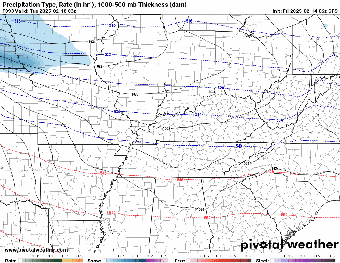
A quick forecast glance. Your 48-hour forecast Graphics


.
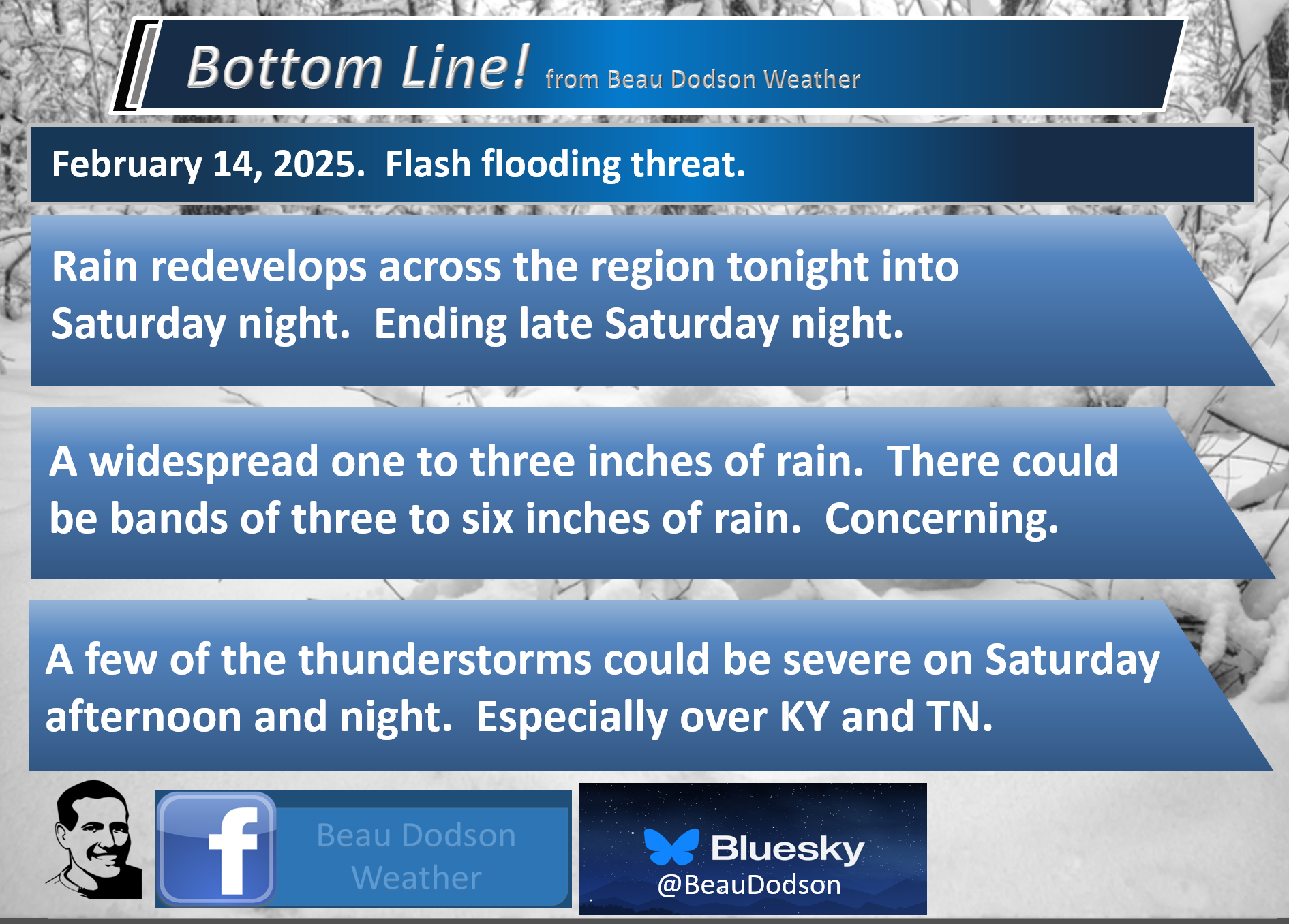
Bottom Line Up Front. An active weather pattern into next week.
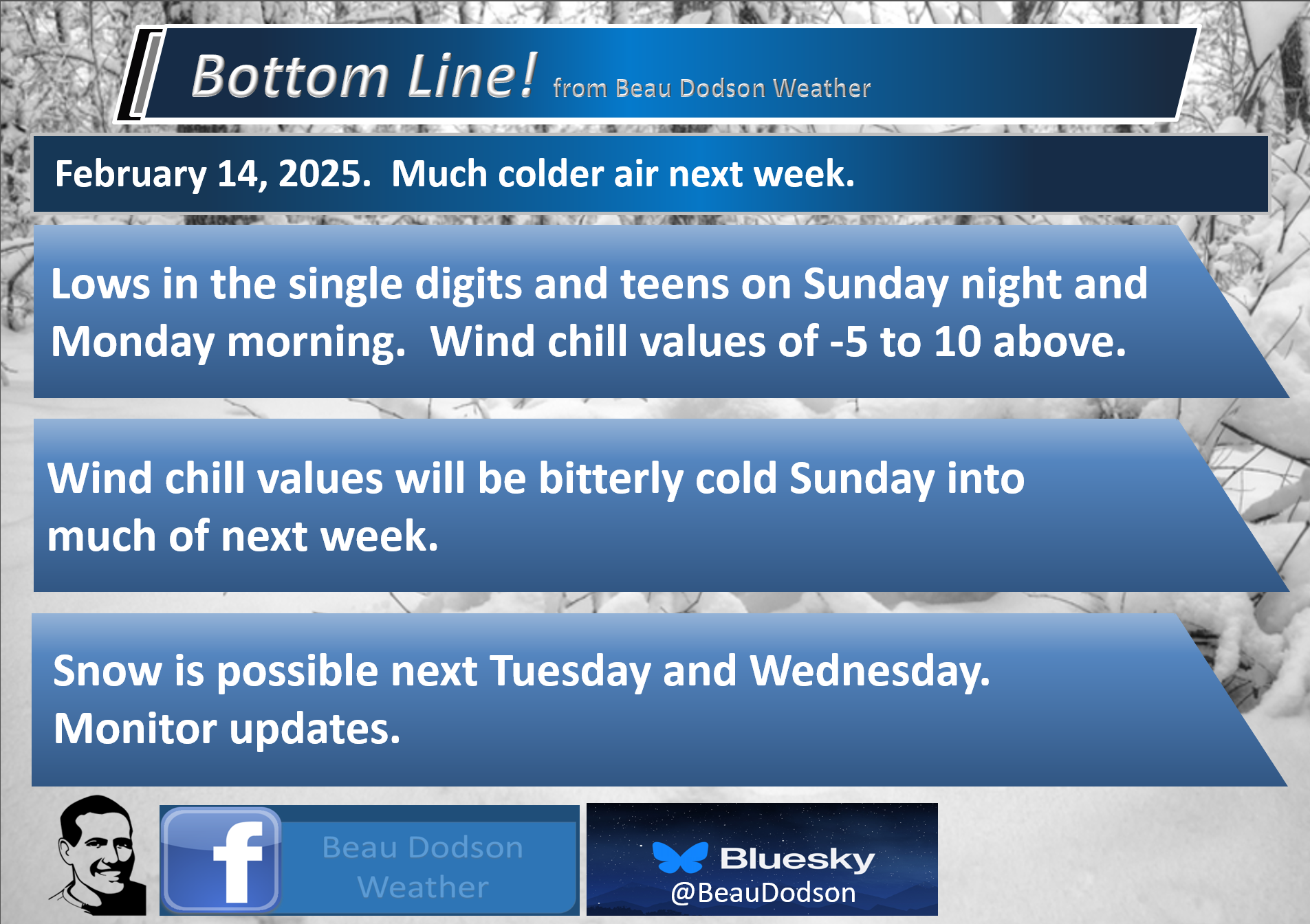
- Chilly today. Warmer air starts moving northward tonight and tomorrow. Bitterly cold next week.
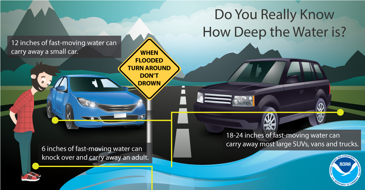
- A flash flood threat will impact portions of our region late tonight into Sunday. I can’t rule out some locations receiving more than four inches of rain. This is concerning. Avoid flooded roadways.
- A few severe thunderstorms are possible Saturday afternoon and night. Mainly over Tennessee and Kentucky.
- The rain may end as snow showers Saturday night/Sunday. Turning sharply colder. Watch for black ice Saturday night/Sunday morning. Temperatures will rapidly fall behind the cold front.
- Sunday night/Monday morning lows will dip into the single digits north and teens south. Wind chill values will range from -5 to 15 above. Cold through next week.
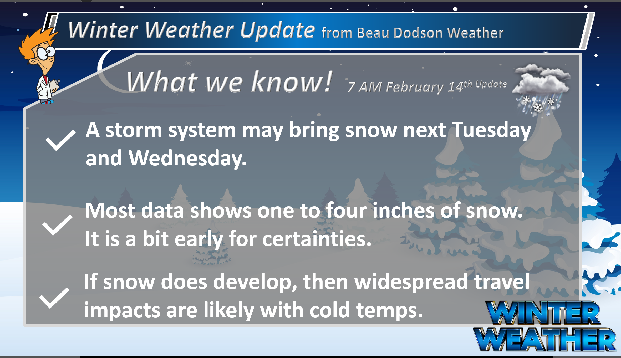
- I am watching a snow event next Tuesday/Wednesday. Accumulating snow is possible. Right now it looks like there is the potential of one to three inches of snow. Still early for certainties.
.
![]()

Here Are Your Beau Dodson Weather Radars And Lightning Data
Don’t forget the local city-view radars have a winterize button. Click that button to see precipitation type.
Interactive-city-view radars. Clickable watches and warnings.
https://wtalk.co/B3XHASFZ
Old legacy radar site (some of you like it better)
https://weatherobservatory.com/weather-radar.htm
Regional Radar
https://imagery.weathertalk.com/prx/RadarLoop.mp4
*NEW* Zoom interactive radar (with storm chaser streams)
https://wtalk.co/AVWG7GM7
Real time lightning tracker system two.
https://map.blitzortung.org/#5.02/37.95/-86.99
Lightning Data (zoom in and out of your local area)
https://wtalk.co/WJ3SN5UZ
.
Bottom Line Up Front
** Flash flooding likely this weekend across portions of the area. Avoid flooded roadways. **
.
.
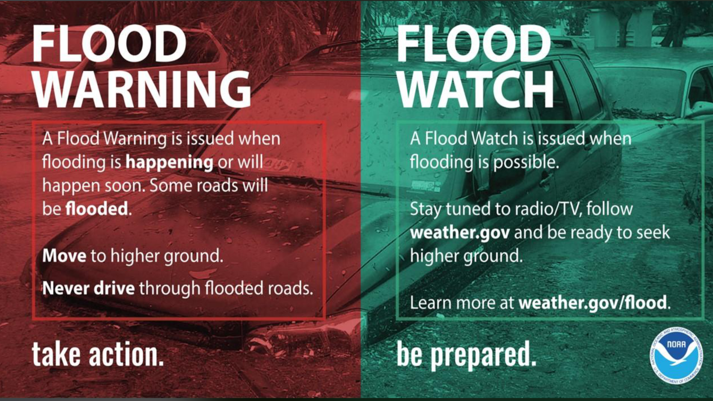
The flood watch has been expanded northwest. This is for late tonight into early Sunday morning.
There remain some questions about where to place the three to six inch rainband. High resolution data shows that it could impact portions of our region. Let’s stay alert for flood and flash flood warnings.
Here is the current flood watch zone (in green).
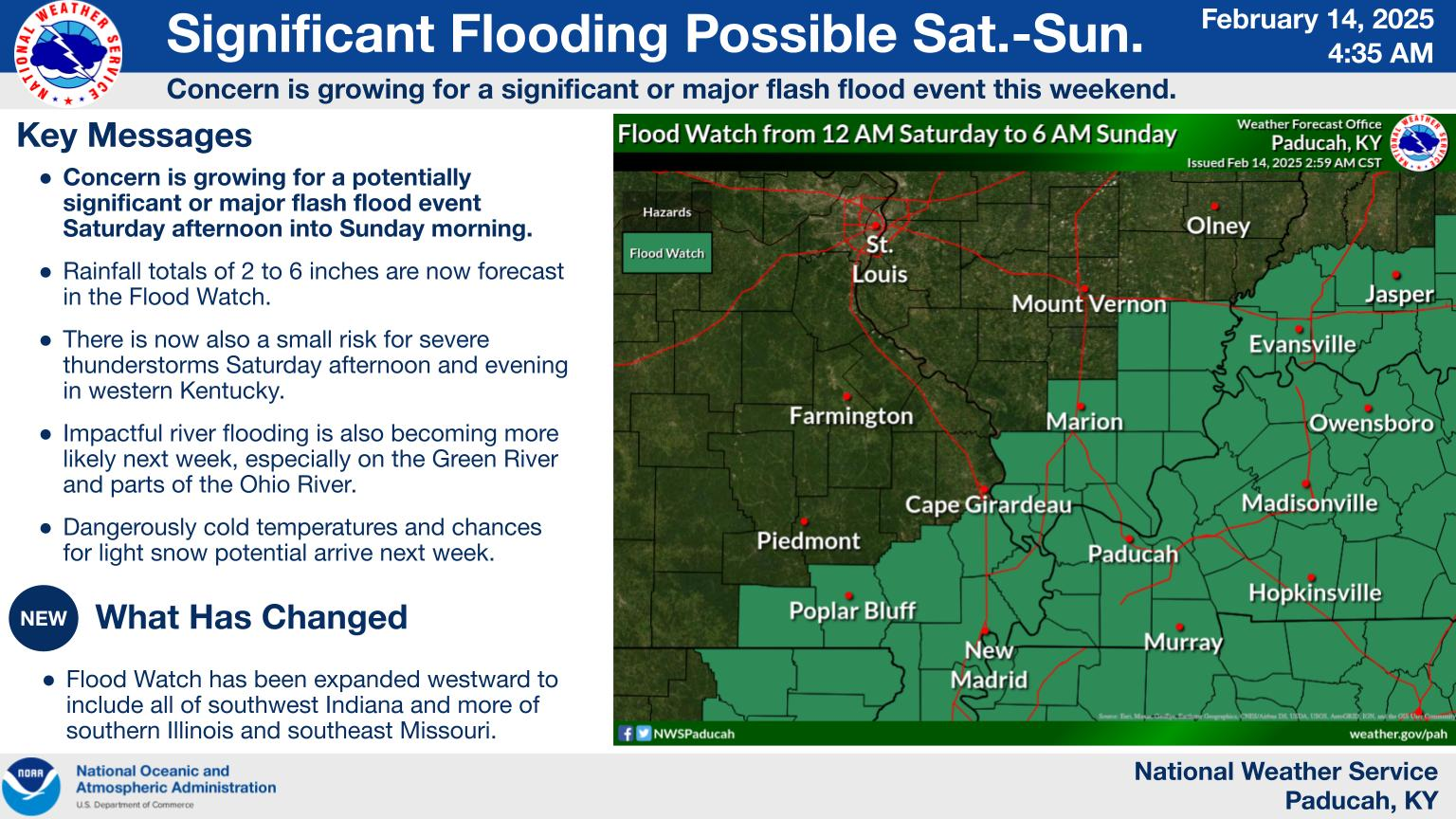
Here is a graphic posted by the NWS. Again, it is important to note that there are differences of opinion on where to place that heaviest rain band.
You can double click this image to enlarge it.
.
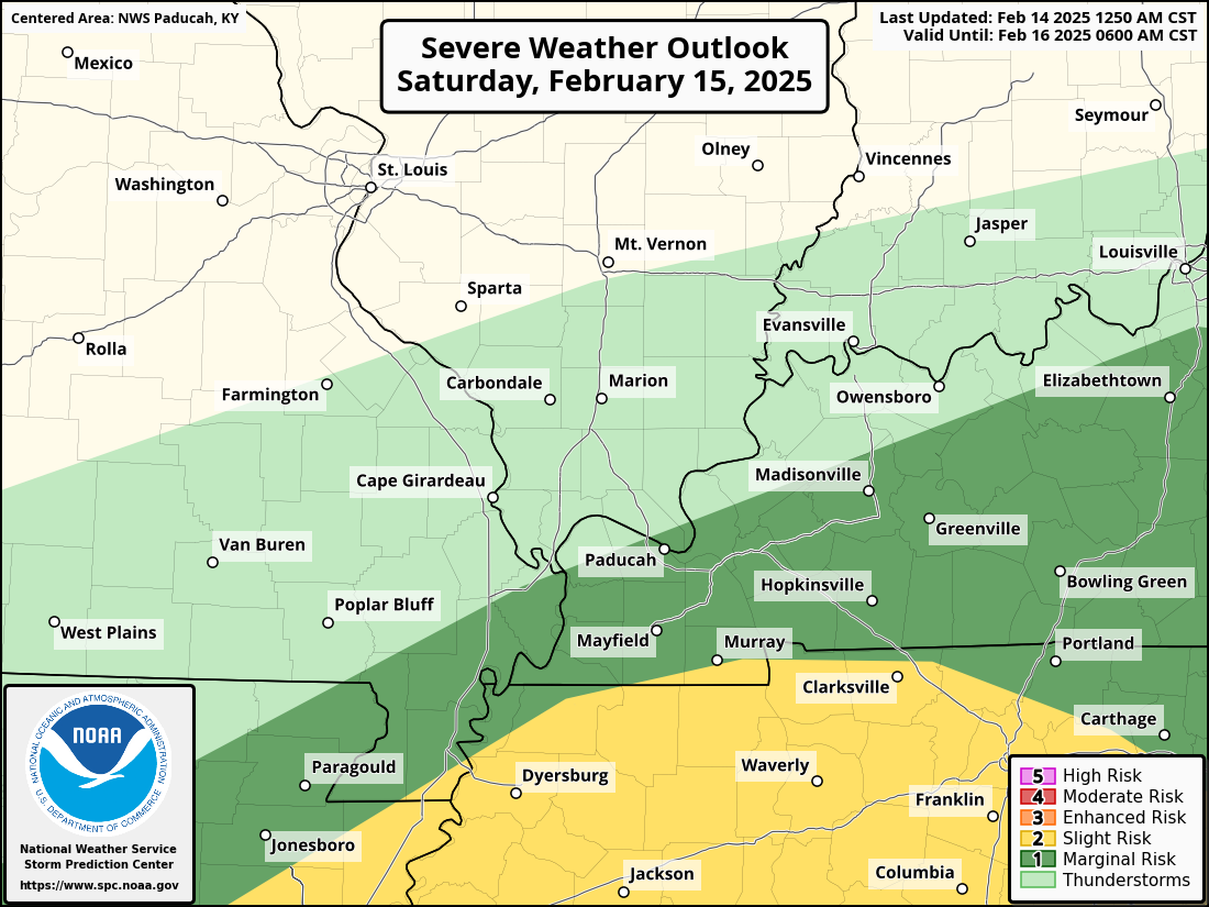
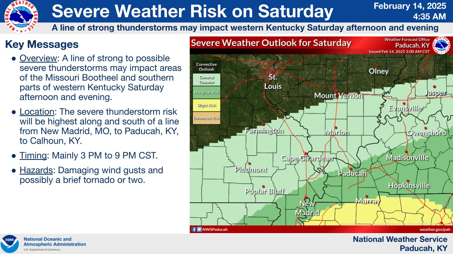
We also have a risk of severe thunderstorms Saturday afternoon and evening.
The light green zone is sub-severe.
The dark green zone is a low-level one marginal risk.
The yellow zone is a level two slight risk. Yellow is the highest risk of the three.
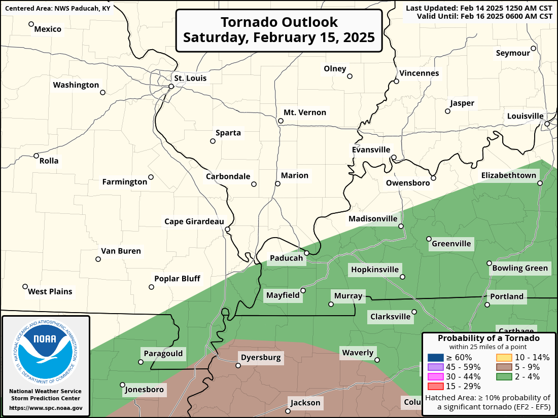
The concern will be damaging wind and tornadoes.
There remain some questions about how far north the warm front will push. The farther north the warm front pushes, the higher the risk of severe weather locally.
Monitor your Beau Dodson Weather App.
.
.
Tornado Outlook
.
This graphic was posted by our friends at the Paducah, Kentucky, NWS.
.
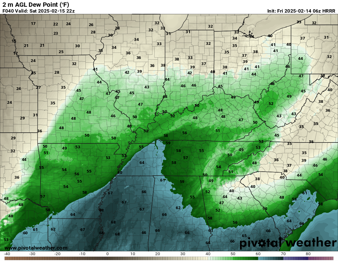
I will be monitoring the warm front Saturday afternoon and evening. Dew points of 58 degrees or above are always concerning during the winter months.
Here is the Saturday afternoon dew point map. The blue colors are 60 degree dew points or higher. How far north those push will determine how far north the severe thunderstorm threat will be.
Dew point is a measure of moisture.
.
Would you like to receive a phone call when a severe thunderstorm or tornado warning is issued?
.
.
.
Today and Tonight’s Weather
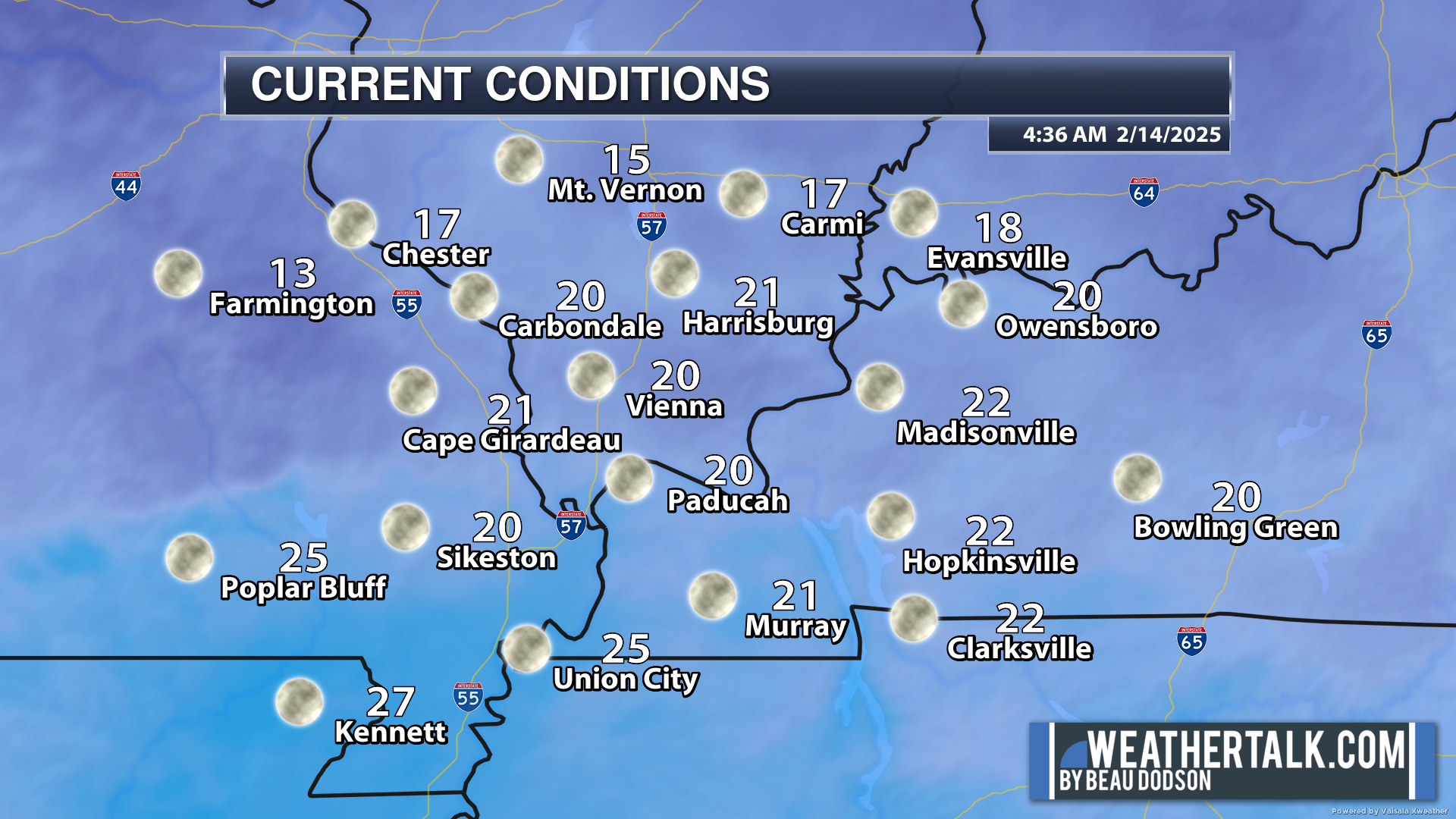
We are waking up to cold temperatures. Brrrr.
Here were the 6 am temperatures.
.
We don’t have any weather concerns through this evening.
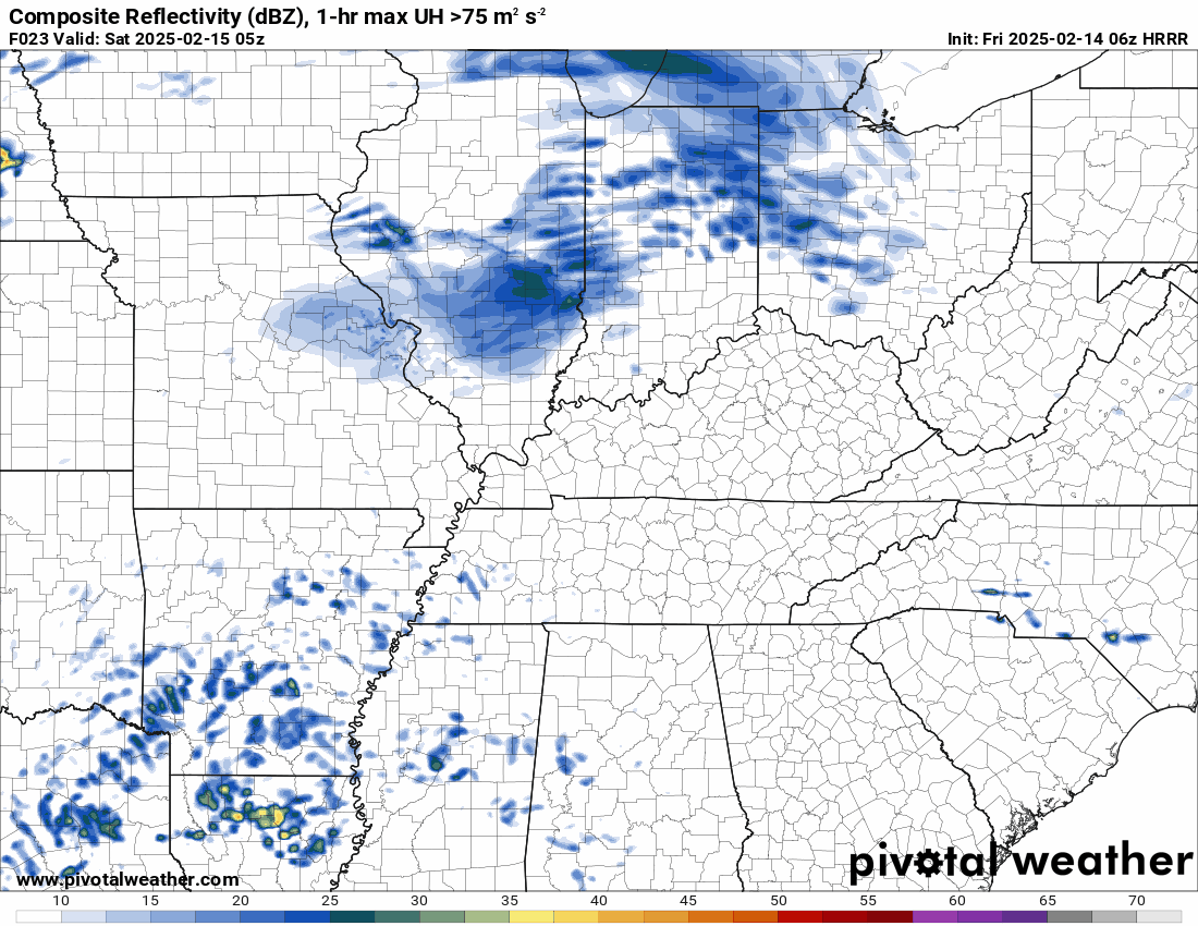
Widespread rain will develop late tonight. See the future-cast radar below.
Some of the rain could be locally heavy. A rumble of thunder possible.
No severe weather concerns today or tonight.
Again, as mentioned above, a flood watch covers much of the area. That will begin tonight.
.
Saturday and Sunday’s Weather
** Flash Flooding And Severe Thunderstorm Risk **
Locally heavy rain is likely this weekend.
A low-level severe thunderstorm risk, as well.
Some significant rainfall totals can’t be ruled out. There remain questions about the placement of a three to six inch band of rain.
We already have river flooding ongoing in the region. Additional rain won’t be welcome.
There will be overland field flooding, ditches flooded, sharp rises on streams, and numerous flooded roadways.
Locally heavy rain with some embedded thunderstorms are likely late Friday night into Saturday evening.
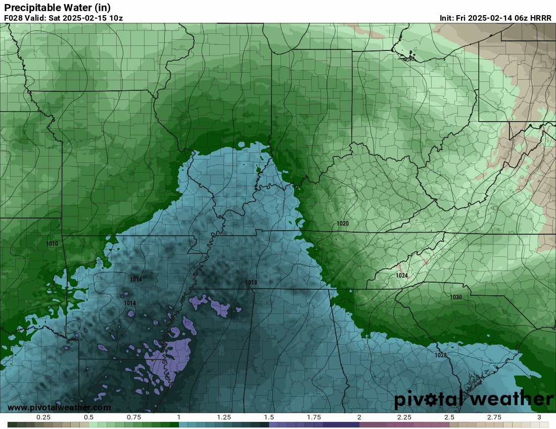
The PWAT values are summer like. You don’t see this in February very often.
PWAT is a measure of moisture. These are extreme numbers for this time of the year. That purple zone is extremely high PWAT values. That is a strong signal for heavy rainfall totals.
.
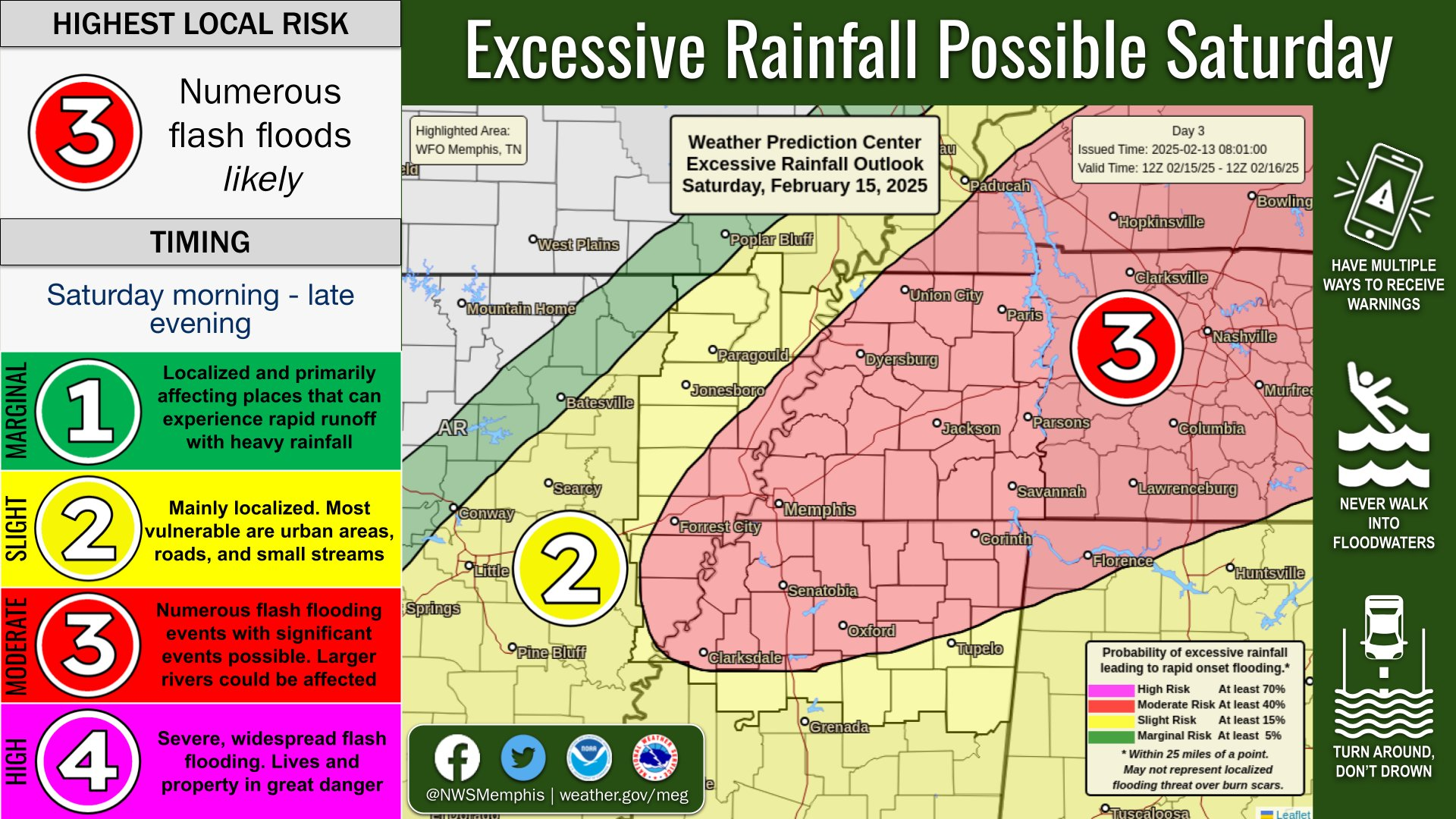
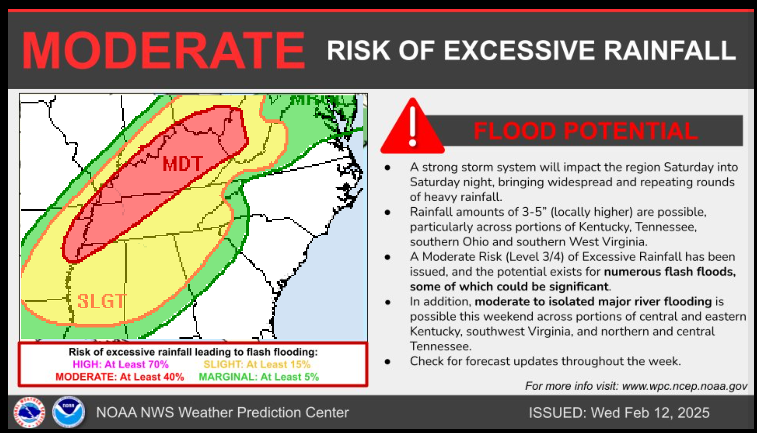
Here is what the WPC/NOAA has outlined for a flooding risk. A moderate risk (red zone) of flash flooding for portions of our region.
This has shifted northwest just a tad.
Avoid flooded roadways.
Double click the image to enlarge it.
.
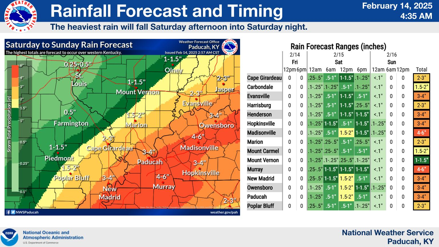
We will need to monitor rain totals, especially over Kentucky and Tennessee.
My current rainfall forecast is
0.50″ to 1.00″ of rain over my northwest counties (northern portions of SE MO and northern portions of southern IL).
1.00″ to 3.00″ of rain across the rest of the region. Pockets of greater than three inches likely. Especially from the Missouri Bootheel into western Tennessee and western Kentucky.
There is a chance of a band of four to six inches of rain in our area.
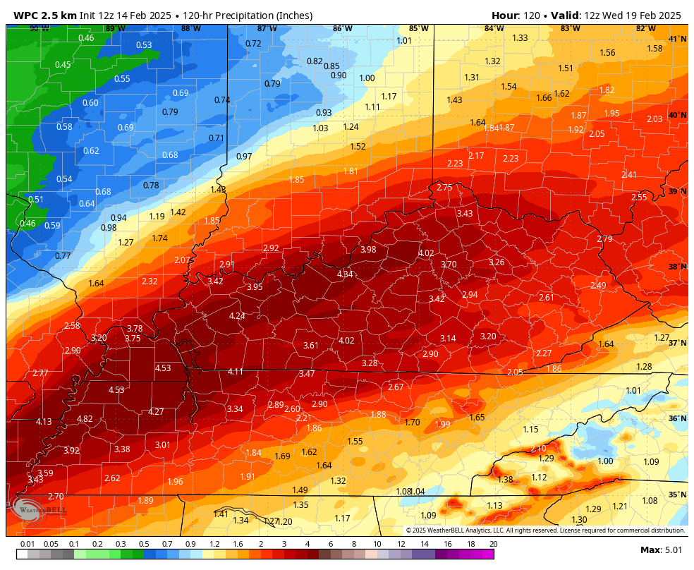
Here is the latest WPC/NOAA rainfall forecast. The higher totals did shift slightly farther northwest. I will keep an eye on this.
.
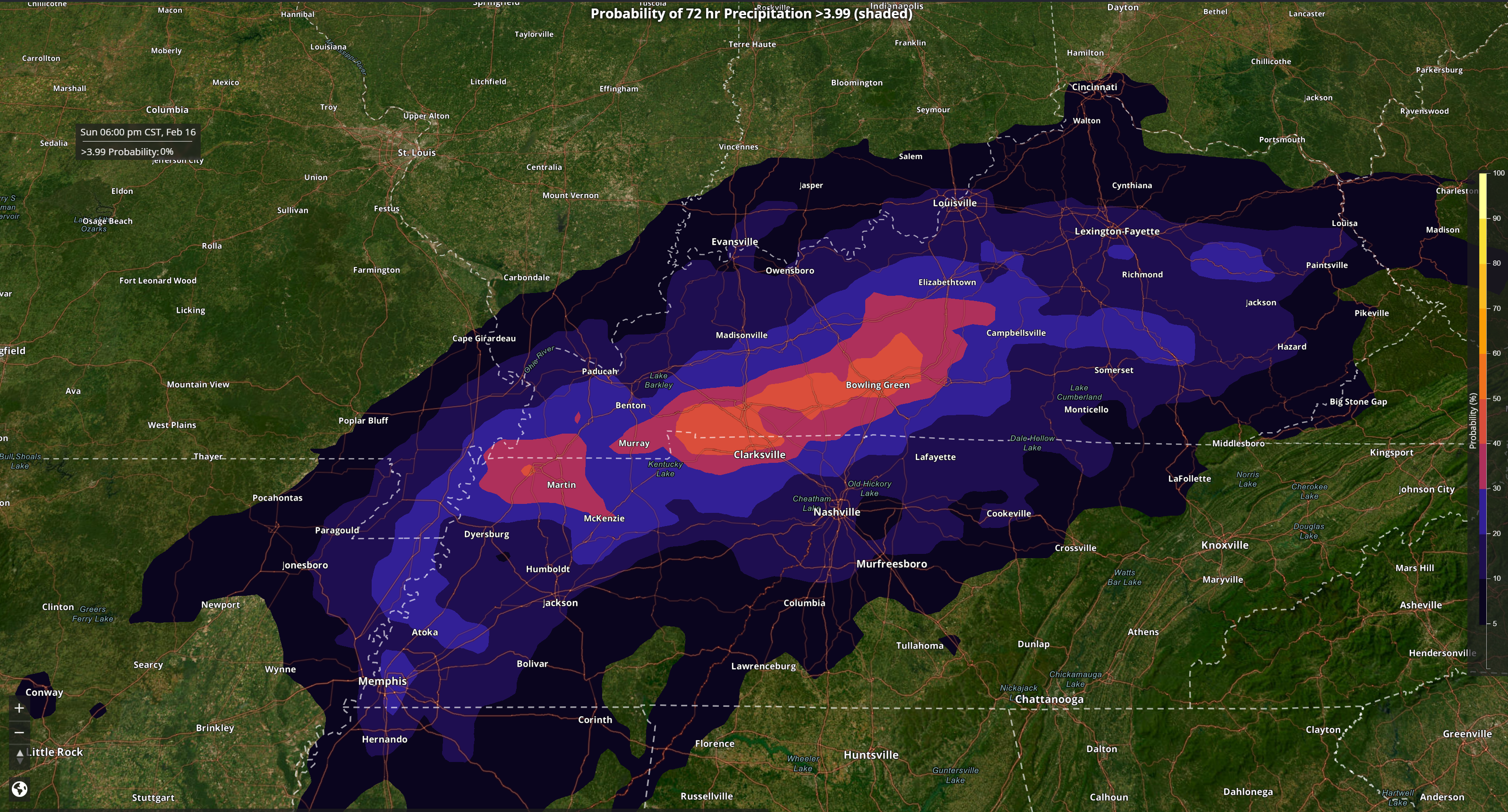
Here is a model probability graphic showing the probability of four or more inches of rain.Notice how it is slanted over our southeastern counties.
This graphic simply shows you where the probabilities are higher for heavier totals.
Double click the image to enlarge it.
.
.
Future-cast Radars.
What radar might look like tonight and tomorrow.
Here is the Hrrr future-cast radar for tonight and tomorrow.
Double click the animations to enlarge them.
The time stamp is in zulu. 12z=6 am. 18z=12 pm. 00z=6 pm.
.
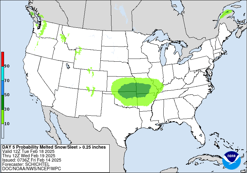
Snow Potential Is Increasing Next Tuesday and Wednesday
.
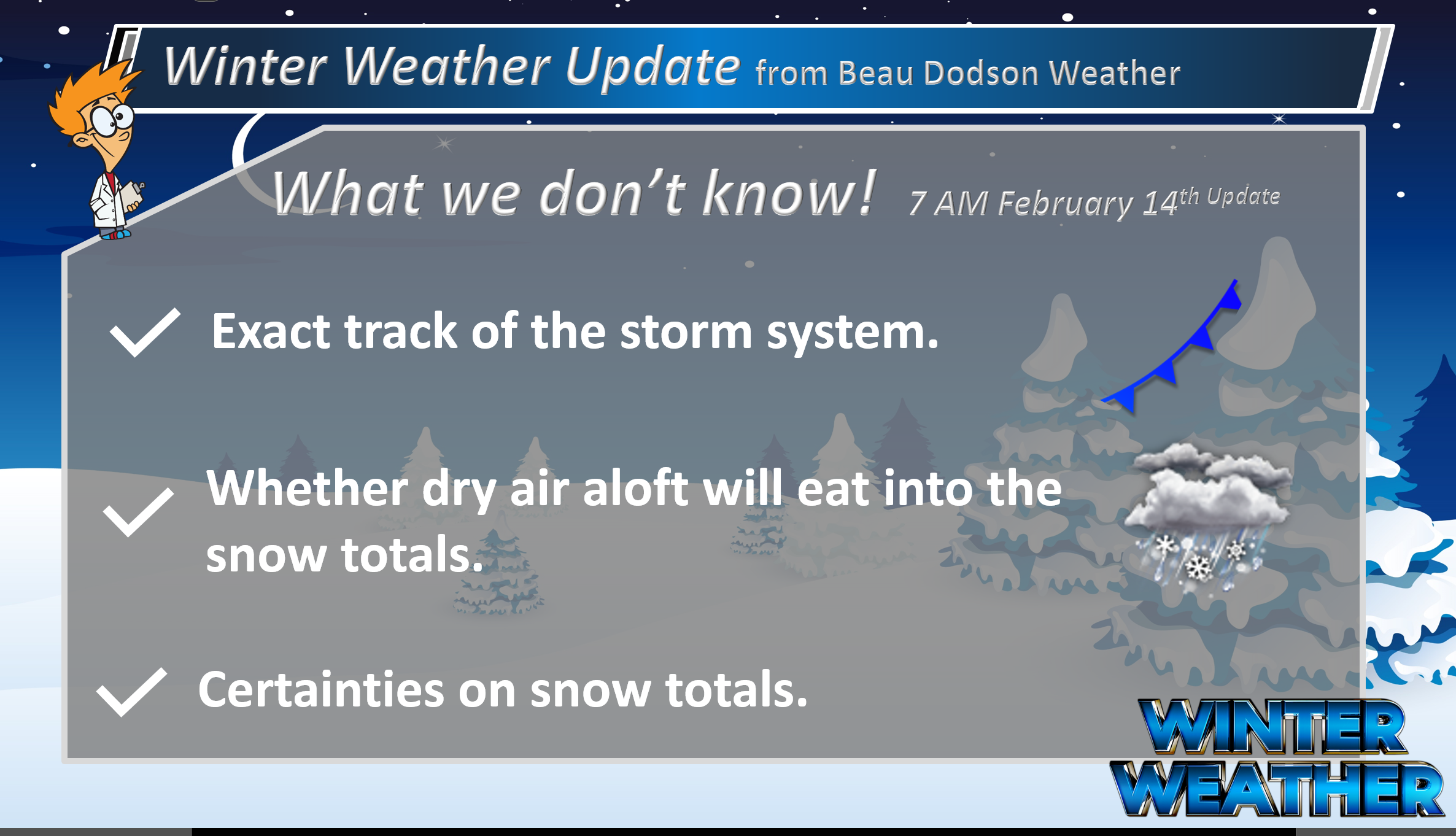
I am tracking more precipitation towards the middle of next week. For now, I am watching Tuesday and Wednesday. Model guidance is showing snow in our region. Cold temperatures, as well.
It is a bit early for certainties on next week’s system. The chance of snow is increasing. Perhaps one to three inches. Snow ratios might be higher than usual with cold temperatures.
Typically, snow ratios are 10:1. That means 0.25″ of liquid equals 2.5″ of snow. We might be looking at 15:1 or higher snow rations. A dry fluffy snow. That could increase amounts.
Again, this is still five to six days out. Adjustments are possible.
Here is what the WPC/NOAA posted for snow next Tuesday and Wednesday.
What is the probability of 2.5″ or more of snow?
.
Future-cast Radars.
What radar might look like next Tuesday and Wednesday
Blue is snow. Red/purple represent ice. Green and yellow represent rain.
Double click the animations to enlarge it.
The time stamp is in zulu. 12z=6 am. 18z=12 pm. 00z=6 pm.
This is the GFS model. One of many models.
Confidence in next week’s system is increasing.
The exact track and intensity of the system will be the determining factor as to how much snow falls.
.

.
My primary concern over the coming days will be the flood threat.
The ground is saturated and flooding is likely going to be an issue with this weekend event.
I expect numerous flood and flash flood warnings.
Widespread flood watches are already in effect. The green zone are flood watches.

Please avoid flooded roadways. You don’t know if the road has been washed away. Use care, as always. Especially at night.
The ground is saturated and flooding is likely going to be an issue with this event.
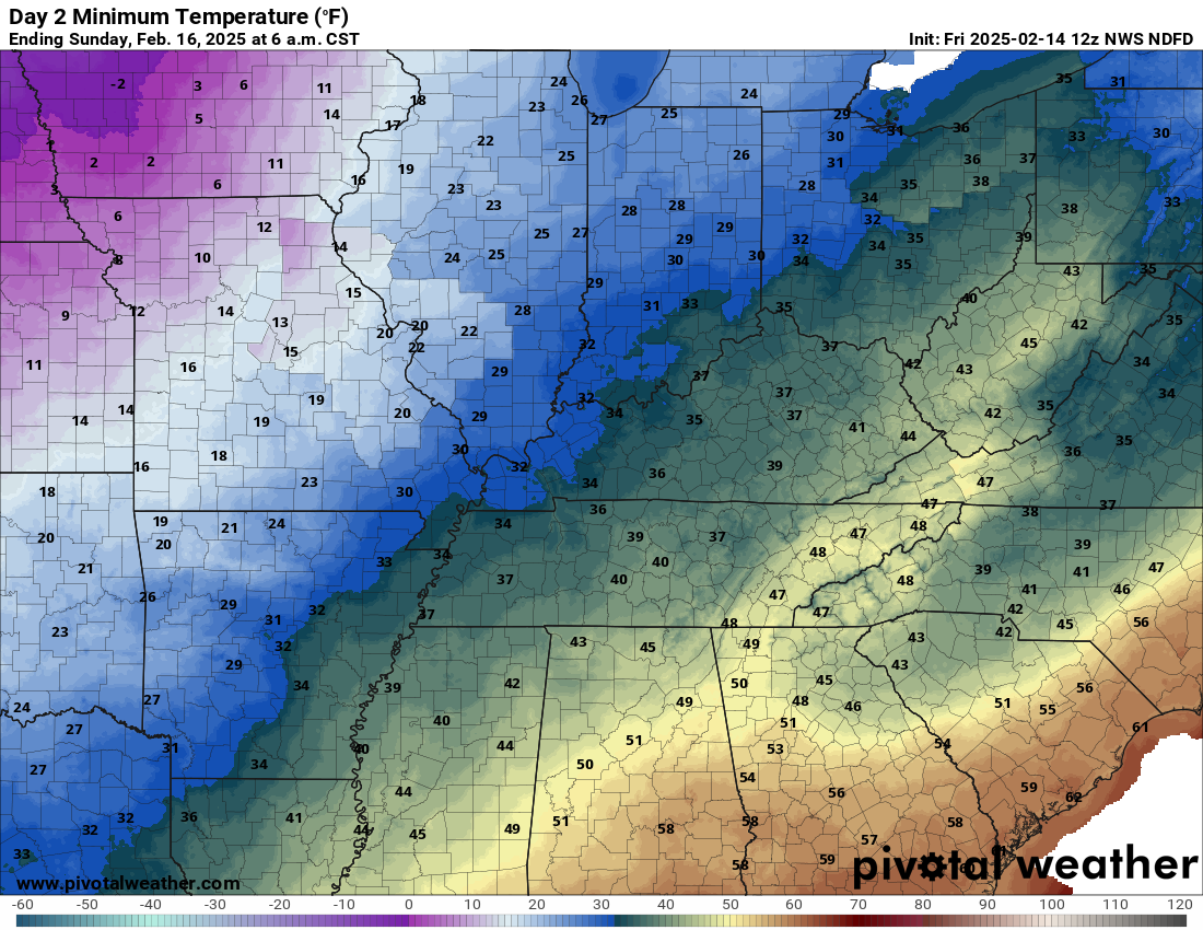
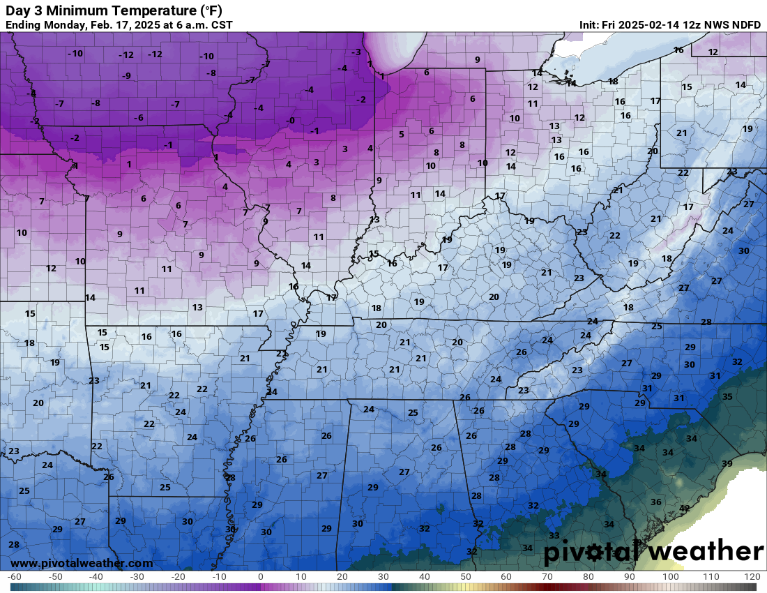
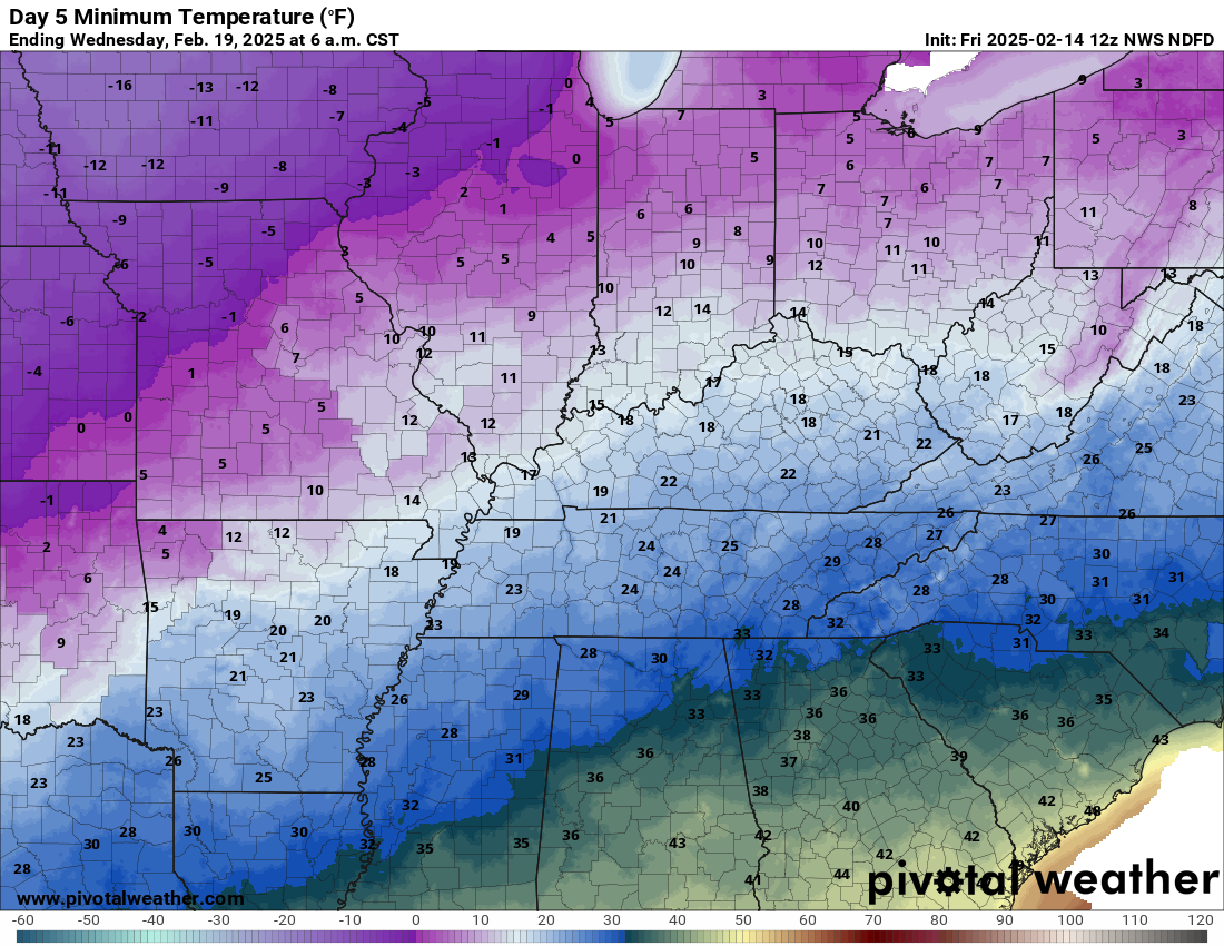
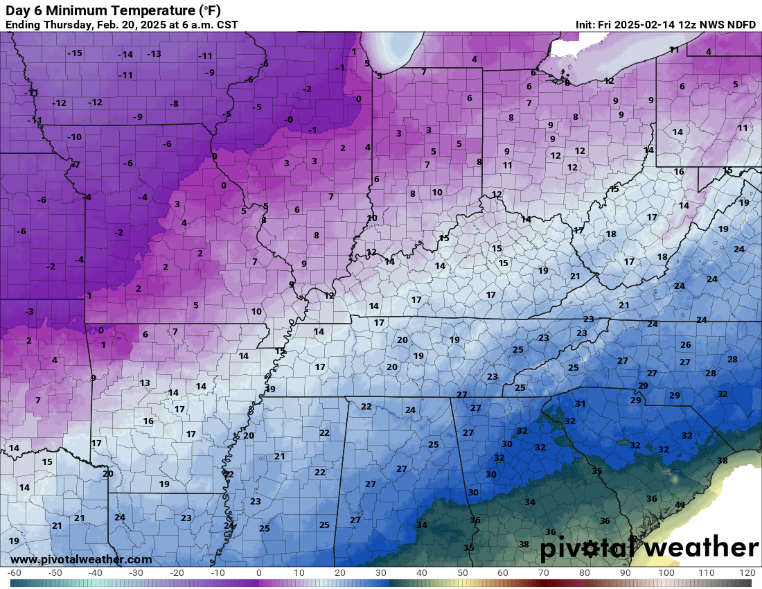
Bitterly cold air filters into the region Sunday and Monday. It will feel like winter.
Check out these lows. Double click images to enlarge them.
Sunday morning lows
Monday morning lows
Tuesday morning lows

Wednesday morning lows
Thursday morning lows
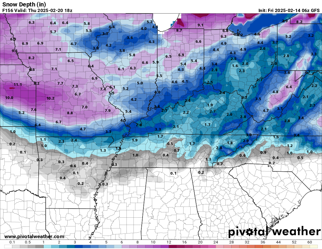
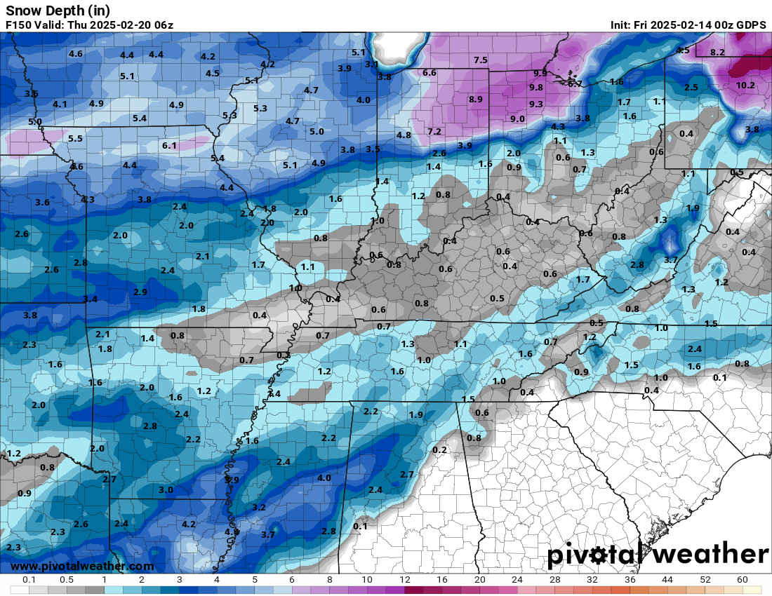
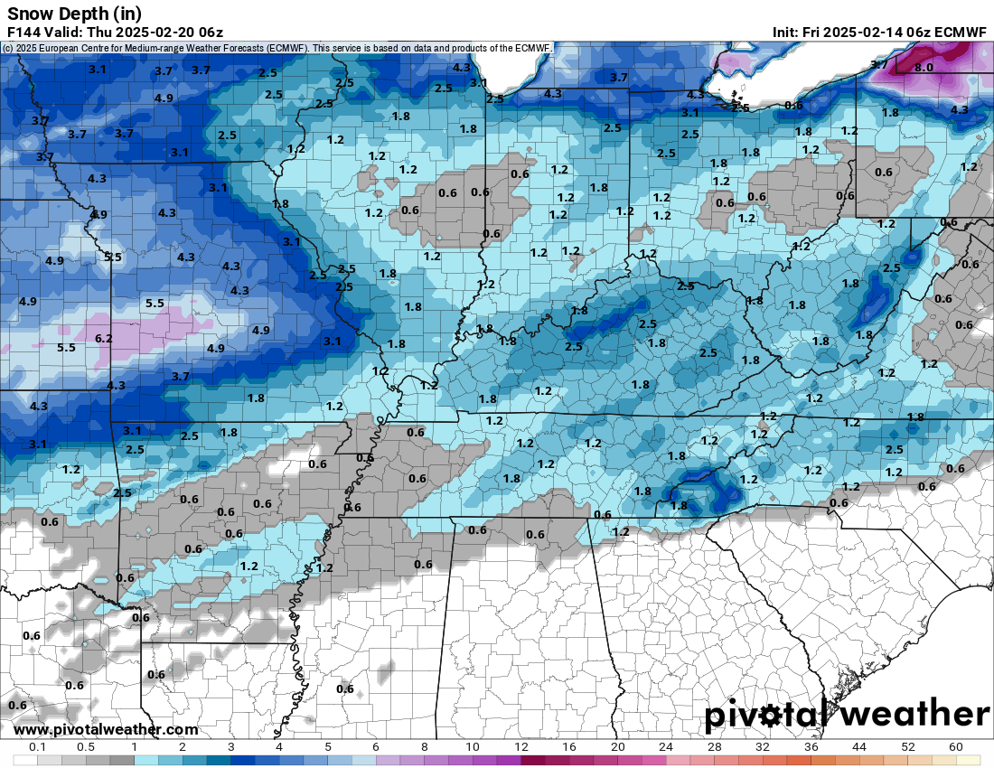
The chance of snow is increasing next Tuesday and Wednesday. It will be cold. What does fall should stick.
Most of the data show one to three inches of snow. Still early for certainties.
Let me show you a few models. This is what models are showing for snow totals.
Double click images to enlarge them
GFS Model
.
Canadian Model
.
European
.
Blend
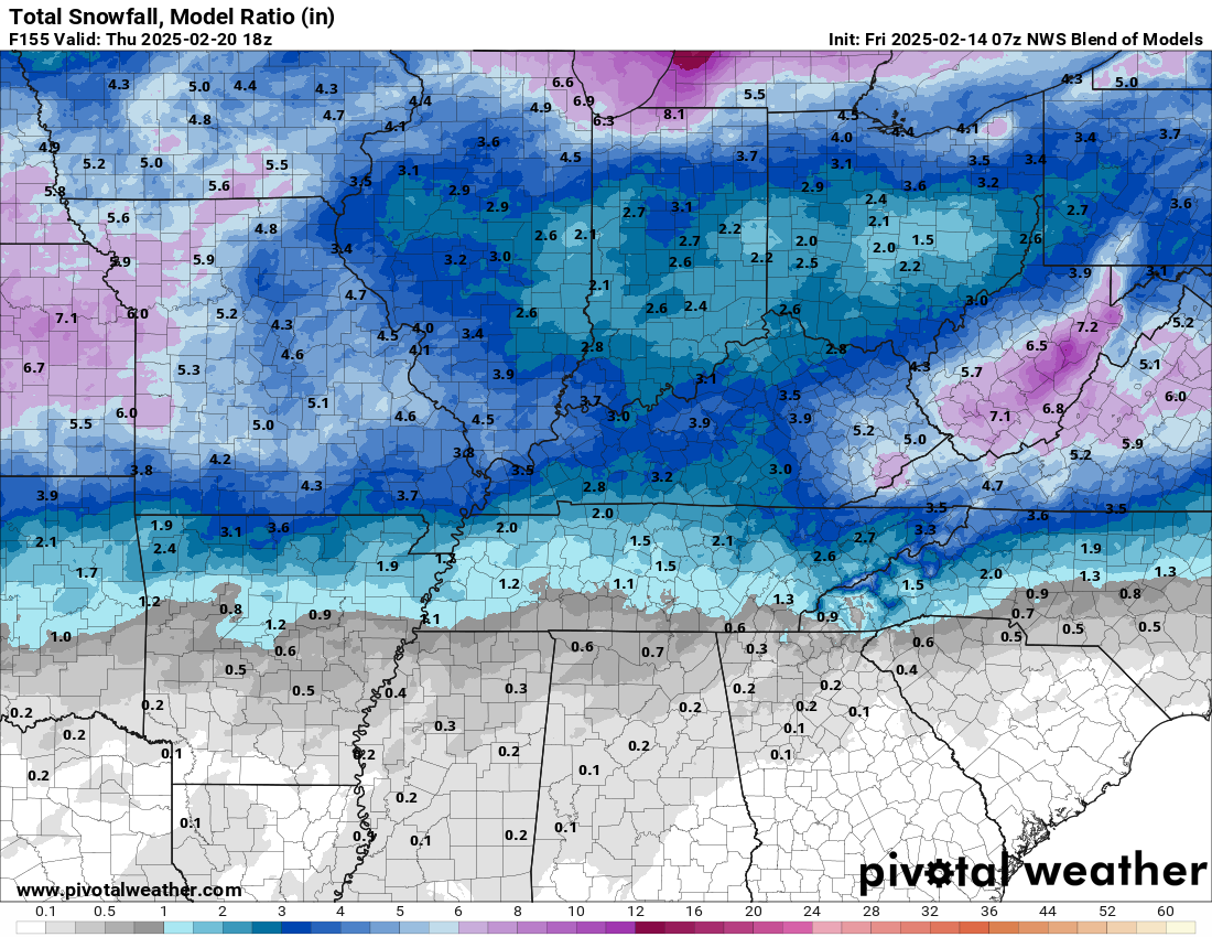
.
Heating problems?
One Hour Heating and Air – Click Here

Connected and Protected.
They Specialize in Audio, Video, Networking, Security, Cameras, Electrical, New Construction, Remodels, and retrofitting Jobs. Experience the future of smart living and unmatched security with Connected & Protected Solutions today.
Link – Click here

Roof damage from recent storms? Link – Click here

![]()
![]()

.
Click here if you would like to return to the top of the page.
.Average high temperatures for this time of the year are around 46 degrees.
Average low temperatures for this time of the year are around 29 degrees.
Average precipitation during this time period ranges from 0.90″ to 1.20″
Six to Ten Day Outlook.
Blue is below average. Red is above average. The no color zone represents equal chances.
Average highs for this time of the year are in the lower 60s. Average lows for this time of the year are in the lower 40s.

Green is above average precipitation. Yellow and brown favors below average precipitation. Average precipitation for this time of the year is around one inch per week.

.

Average low temperatures for this time of the year are around 29 degrees.
Average precipitation during this time period ranges from 0.90″ to 1.20″
.
Eight to Fourteen Day Outlook.
Blue is below average. Red is above average. The no color zone represents equal chances.

Green is above average precipitation. Yellow and brown favors below average precipitation. Average precipitation for this time of the year is around one inch per week.

.
![]()
Make sure you have three to five ways of receiving your severe weather information.
Weather Talk is one of those ways! Now, I have another product for you and your family.

.
.
https://weathercallservices.com/beau-dodson-weather


Want to add more products to your Beau Dodson Weather App?
Receive daily videos, weather blog updates on normal weather days and severe weather and winter storm days, your county by county weather forecast, and more!
Here is how to do add those additional products to your app notification settings!
Here is a video on how to update your Beau Dodson Weather payment.
The app is for subscribers. Subscribe at www.weathertalk.com/welcome then go to your app store and search for WeatherTalk
Subscribers, PLEASE USE THE APP. ATT and Verizon are not reliable during severe weather. They are delaying text messages.
The app is under WeatherTalk in the app store.

Apple users click here

Android users click here
.
Radars and Lightning Data
Interactive-city-view radars. Clickable watches and warnings.
https://wtalk.co/B3XHASFZ
Old legacy radar site (some of you like it better)
https://weatherobservatory.com/weather-radar.htm
If the radar is not updating then try another one. If a radar does not appear to be refreshing then hit Ctrl F5. You may also try restarting your browser.
Backup radar site in case the above one is not working.
https://weathertalk.com/morani
Regional Radar
https://imagery.weathertalk.com/prx/RadarLoop.mp4
** NEW ** Zoom radar with chaser tracking abilities!
ZoomRadar
Lightning Data (zoom in and out of your local area)
https://wtalk.co/WJ3SN5UZ
Not working? Email me at beaudodson@usawx.com
National map of weather watches and warnings. Click here.
Storm Prediction Center. Click here.
Weather Prediction Center. Click here.
.

Live lightning data: Click here.
Real time lightning data (another one) https://map.blitzortung.org/#5.02/37.95/-86.99
Our new Zoom radar with storm chases
.
.

Interactive GOES R satellite. Track clouds. Click here.
GOES 16 slider tool. Click here.
College of DuPage satellites. Click here
.

Here are the latest local river stage forecast numbers Click Here.
Here are the latest lake stage forecast numbers for Kentucky Lake and Lake Barkley Click Here.
.
.
Find Beau on Facebook! Click the banner.


 .
.