.

Click one of the links below to take you directly to each section.
If a link is broken then please let me know. Beaudodson@usawx.com
-
- Go to storm tracking tools. Radars, lightning, & satellite
- Go to today’s forecast
- Go to the city-view graphic-casts
- Go to the severe weather outlook
- Go to the weather forecast discussion
- Go to the model future-cast radars
- Go to videos
- Go to weeks one, two, three, and four temperature & precipitation graphics
- Go to the autumn outlook.
- Go to the winter outlook,
- Go to Weatherbrains
- View our community charity work. Your subscription dollars help support these causes.
- County maps. I made a page with county maps. Some of you requested this.
Do you have questions or suggestions? If so, please email me. Beaudodson@usawx.com
.
Quick Glance
.


.
Your seven-day outlook.

.
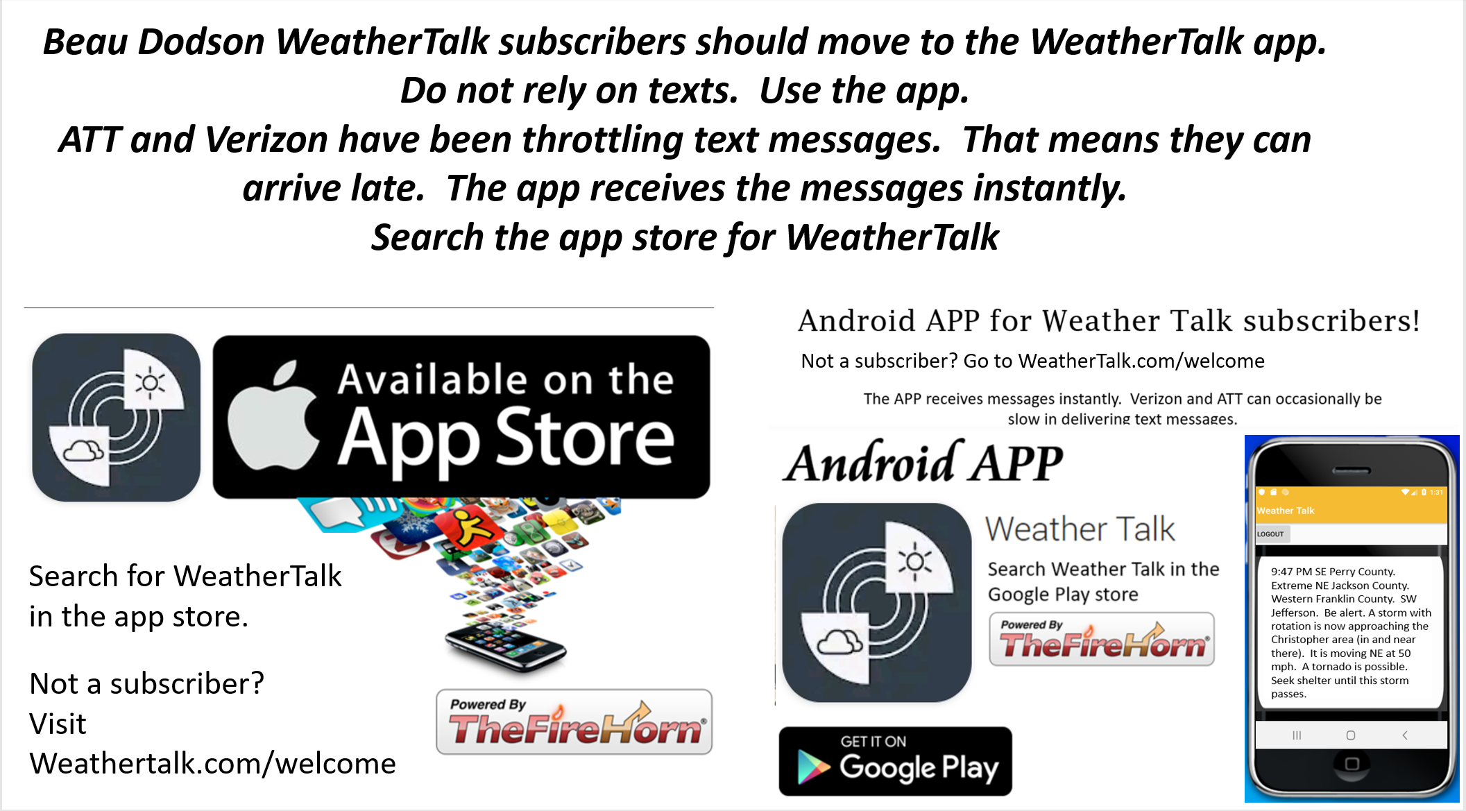
Not receiving app/text messages?
USE THE APP. ATT and Verizon are slowing or stopping the text messages.
Make sure you have the correct app/text options turned on. Find those under the personal notification settings tab at www.weathertalk.com. Red is off. Green is on.
Subscribers, PLEASE USE THE APP. ATT and Verizon are not reliable during severe weather. They are delaying text messages.
The app is under WeatherTalk in the app store.

Apple users click here

Android users click here
.
Tuesday through Thursday
- Is lightning in the forecast? No.
- Are severe thunderstorms in the forecast? No.
* The NWS officially defines severe weather as 58 mph wind or great, 1″ hail or larger, and/or tornadoes - Is flash flooding in the forecast? No.
- Is ACCUMULATING snow or ice in the forecast? No. There could be a brief period of sleet or snow Thursday morning. For now, I have the precip arriving a bit later in the day.
- Will wind chill values drop below 10 degrees? No.
.
Friday through Monday
- Is lightning in the forecast? Possible. Sunday night.
- Are severe thunderstorms in the forecast? No:
- * The NWS officially defines severe weather as 58 mph wind or great, 1″ hail or larger, and/or tornadoes
- Is flash flooding in the forecast? No.
- Is ACCUMULATING snow or ice in the forecast? No.
- Will wind chill values drop below 10 degrees? No.
.,
Click here if you would like to return to the top of the page.
.
.
Click here if you would like to return to the top of the page.
.

.
County Maps: Click Here
Have there been any significant changes in the forecast over the last 24 hours?
Lowered rain chances on Thursday night.
.
What changes might occur in the forecast?
Sunday into Tuesday. Rain chances and coverage. Monitor for adjustments.
Click here if you would like to return to the top of the page.
.

** The new app is finished. Make sure you have the new one. If not, go to WeatherTalk in the app store. Download the new app. Notice the icon is no longer orange. It is a grey/dark color **
.

Radar Link: Interactive local city-view radars & regional radars.
.
December 3, 2019
Tuesday’s Forecast: Intervals of clouds. Becoming breezy. Milder.
What is the chance of precipitation? MO ~ 0% IL ~ 0% KY ~ 0% TN ~ 0%
How confident am I that this forecast will verify: High (70% confidence in the forecast)
Temperature range: MO Bootheel 48° to 54° SE MO 48° to 54° South IL 48° to 54° Northwest KY (near Indiana border) 48° to 54° West KY 50° to 54° NW TN 52° to 55°
Wind direction and speed: Southwest increasing to 8 to 16 mph and gusty
Wind chill or heat index (feels like) temperature forecast: 48° to 54°
Coverage of precipitation: None
What impacts are anticipated from the weather? None
What action is required: None
Should I cancel my outdoor plans? No.
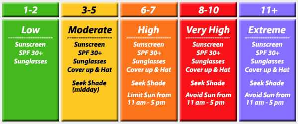
UV Index: 2 Low
Sunrise: 6:52 AM
.
Tuesday night Forecast: Partly cloudy. Clouds decreasing.
What is the chance of precipitation? MO ~ 0% IL ~ 0% KY ~ 0% TN ~ 0%
How confident am I that this forecast will verify: High (80% confidence in the forecast)
Temperature range: MO Bootheel 32° to 35° SE MO 30° to 34° South IL 30° to 34° Northwest KY (near Indiana border) 32° to 34° West KY 32° to 34° NW TN 33° to 36°
Wind direction and speed: Southwest becoming west at 5 to 10 mph
Wind chill or heat index (feels like) temperature forecast: 30° to 35°
Coverage of precipitation: None
What impacts are anticipated from the weather? None
What action is required: None
Should I cancel my outdoor plans? No.
Sunset: 4:37 PM
Moonrise: 12:27 PM
The phase of the moon: Waxing Crescent
Moonset: 11:24 PM
.
December 4, 2019
Wednesday’s Forecast: Mostly sunny.
What is the chance of precipitation? MO ~ 0% IL ~ 0% KY ~ 0% TN ~ 0%
How confident am I that this forecast will verify: Medium (60% confidence in the forecast)
Temperature range: MO Bootheel 53° to 56° SE MO 53° to 56° South IL 50° to 55° Northwest KY (near Indiana border) 50° to 55° West KY 50° to 55° NW TN 50° to 55°
Wind direction and speed: West at 5 to 10 mph
Wind chill or heat index (feels like) temperature forecast: 50° to 55°
Coverage of precipitation: None
What impacts are anticipated from the weather? None
What action is required: None
Should I cancel my outdoor plans? None
UV Index: 3 Moderate
Sunrise: 6:53 AM
.
Wednesday night Forecast: Mostly clear. A few late-night clouds.
What is the chance of precipitation? MO ~ 0% IL ~ 0% KY ~ 0% TN ~ 0%
How confident am I that this forecast will verify: Medium (60% confidence in the forecast)
Temperature range: MO Bootheel 32° to 34° SE MO 30° to 34° South IL 30° to 34° Northwest KY (near Indiana border) 30° to 34° West KY 30° to 34° NW TN 32° to 34°
Wind direction and speed: Light wind
Wind chill or heat index (feels like) temperature forecast: 30° to 35°
Coverage of precipitation: None
What impacts are anticipated from the weather? None.
What action is required: None.
Should I cancel my outdoor plans? No
Sunset: 4:37 PM
Moonrise: 12:54 PM
The phase of the moon: First Quarter
Moonset: 12:01 AM
.
December 5, 2019
Thursday’s Forecast: Increasing clouds from west to east. A shower is possible during the PM hours over southeast Missouri.
What is the chance of precipitation? MO ~ 20% IL ~ 10% KY ~ 20% TN ~ 20%
How confident am I that this forecast will verify: Medium (60% confidence in the forecast)
Temperature range: MO Bootheel 52° to 54° SE MO 50° to 54° South IL 50° to 55° Northwest KY (near Indiana border) 52° to 54° West KY 52° to 54° NW TN 52° to 54°
Wind direction and speed: South at 5 to 10 mph
Wind chill or heat index (feels like) temperature forecast: 50° to 55°
Coverage of precipitation: None during the AM hours. A few showers may move into southeast Missouri late in the day.
What impacts are anticipated from the weather? Isolated wet roadways over southeast Missouri. Lesser chances elsewhere.
What action is required: None
Should I cancel my outdoor plans? No
UV Index: 1 Low
Sunrise: 6:54 AM
.
Thursday night Forecast: Cloudy. A chance of showers. The best chance will be along the Missouri and Arkansas border and then into western Tennessee. This system may stay further south than originally thought.
What is the chance of precipitation? MO ~ 50% IL ~ 30% KY ~ 40% TN ~ 50%
How confident am I that this forecast will verify: Medium (40% confidence in the forecast)
Temperature range: MO Bootheel 40° to 44° SE MO 38° to 44° South IL 38° to 44° Northwest KY (near Indiana border) 40° to 44° West KY 40° to 44° NW TN 40° to 44°
Wind direction and speed: Southeast wind at 5 to 10 mph
Wind chill or heat index (feels like) temperature forecast: 40° to 45°
Coverage of precipitation: Scattered
What impacts are anticipated from the weather? Wet roadways.
What action is required: Slow your vehicle on wet roadways. There is a 34 percent increase in the risk of a fatal crash when precipitation is falling.
Should I cancel my outdoor plans? No. Monitor updates.
Sunset: 4:37 PM
Moonrise: 1:18 PM
The phase of the moon: Waxing Gibbous
Moonset: 12:20 AM
.
December 6, 2019
Friday’s Forecast: Mostly cloudy with a slight chance of rain showers in the morning. Becoming partly cloudy.
What is the chance of precipitation? MO ~ 20% IL ~ 10% KY ~ 20% TN ~ 30%
How confident am I that this forecast will verify: Medium (40% confidence in the forecast)
Temperature range: MO Bootheel 52° to 54° SE MO 50° to 54° South IL 48° to 52° Northwest KY (near Indiana border) 50° to 54° West KY 50° to 54° NW TN 50° to 54°
Wind direction and speed: Northeast at 5 mph
Wind chill or heat index (feels like) temperature forecast: 50° to 55°
Coverage of precipitation: Isolated
What impacts are anticipated from the weather? Isolated wet roadways.
What action is required: Slow your vehicle on wet roadways. There is a 34 percent increase in the risk of a fatal crash when precipitation is falling.
Should I cancel my outdoor plans? No.
UV Index: 1 Low
Sunrise: 6:53 AM
.
Friday night Forecast: Clearing. Chilly.
What is the chance of precipitation? MO ~ 0% IL ~ 0% KY ~ 0% TN ~ 0%
How confident am I that this forecast will verify: Medium (50% confidence in the forecast)
Temperature range: MO Bootheel 28° to 32° SE MO 26° to 30° South IL 26° to 30° Northwest KY (near Indiana border) 28° to 30° West KY 28° to 30° NW TN 30° to 34°
Wind direction and speed: Northeast at 4 to 8 mph
Wind chill or heat index (feels like) temperature forecast: 30° to 35°
Coverage of precipitation: None
What impacts are anticipated from the weather? None
What action is required: None.
Should I cancel my outdoor plans? No
Sunset: 4:37 PM
Moonrise: 1:47 PM
The phase of the moon: Waxing Gibbous
Moonset: 1:17 AM
.
December 7, 2019
Saturday’s Forecast: Mostly sunny. Cool.
What is the chance of precipitation? MO ~ 0% IL ~ 0% KY ~ 0% TN ~ 0%
How confident am I that this forecast will verify: Medium (60% confidence in the forecast)
Temperature range: MO Bootheel 50° to 54° SE MO 48° to 54° South IL 48° to 52° Northwest KY (near Indiana border) 50° to 54° West KY 50° to 54° NW TN 50° to 54°
Wind direction and speed: Southeast at 5 to 10 mph
Wind chill or heat index (feels like) temperature forecast: 48° to 54°
Coverage of precipitation: None
What impacts are anticipated from the weather? None
What action is required: None
Should I cancel my outdoor plans? No.
UV Index: 3 Moderate
Sunrise: 6:56 AM
.
Saturday night Forecast: Mostly clear early. Some increase in clouds late.
What is the chance of precipitation? MO ~ 0% IL ~ 0% KY ~ 0% TN ~ 0%
How confident am I that this forecast will verify: Medium (60% confidence in the forecast)
Temperature range: MO Bootheel 35° to 40° SE MO 35° to 40° South IL 35° to 40° Northwest KY (near Indiana border) 35° to 40° West KY 35° to 40° NW TN 35° to 40°
Wind direction and speed: South at 5 to 10 mph
Wind chill or heat index (feels like) temperature forecast: 34° to 38°
Coverage of precipitation: None
What impacts are anticipated from the weather? None
What action is required: None.
Should I cancel my outdoor plans? No
Sunset: 4:37 PM
Moonrise: 2:13 PM
The phase of the moon: Waxing Gibbous
Moonset: 2:13 AM
.
December 8, 2019
Sunday’s Forecast: Intervals of clouds. Warmer. A shower is possible. Showers are more likely on Sunday night into Monday.
What is the chance of precipitation? MO ~ 30% IL ~ 30% KY ~ 30% TN ~ 30%
How confident am I that this forecast will verify: Low (30% confidence in the forecast)
Temperature range: MO Bootheel 54° to 58° SE MO 54° to 58° South IL 54° to 58° Northwest KY (near Indiana border) 54° to 58° West KY 54° to 58° NW TN 54° to 58°
Wind direction and speed: Southwest 10 to 20 mph
Wind chill or heat index (feels like) temperature forecast: 50° to 55°
Coverage of precipitation: Scattered
What impacts are anticipated from the weather? Scattered wet roadways.
What action is required: Slow your vehicle on wet roadways. There is a 34 percent increase in the risk of a fatal crash when precipitation is falling.
Should I cancel my outdoor plans? No. Monitor updates.
UV Index: 2 Low
Sunrise: 6:57 AM
.
Sunday night Forecast: Becoming cloudy. A chance of showers. A thunderstorm is possible.
What is the chance of precipitation? MO ~ 40% IL ~ 40% KY ~ 40% TN ~ 40%
How confident am I that this forecast will verify: Low (30% confidence in the forecast)
Temperature range: MO Bootheel 40° to 45° SE MO 40° to 45° South IL 40° to 45° Northwest KY (near Indiana border) 40° to 45° West KY 40° to 45° NW TN 42° to 44°
Wind direction and speed: Southwest at 6 to 12 mph
Wind chill or heat index (feels like) temperature forecast: 38° to 42°
Coverage of precipitation: Scattered
What impacts are anticipated from the weather? Wet roadways.
What action is required: Slow your vehicle on wet roadways. There is a 34 percent increase in the risk of a fatal crash when precipitation is falling.
Should I cancel my outdoor plans? Have a plan B and monitor updates.
Sunset: 4:37 PM
Moonrise: 2:41 PM
The phase of the moon: Waxing Gibbous
Moonset: 3:11 AM
.
December 9, 2019
Monday’s Forecast: Intervals of clouds. Scattered showers.
What is the chance of precipitation? MO ~ 40% IL ~ 40% KY ~ 40% TN ~ 30%
How confident am I that this forecast will verify: Low (30% confidence in the forecast)
Temperature range: MO Bootheel 50° to 55° SE MO 50° to 55° South IL 50° to 55° Northwest KY (near Indiana border) 50° to 55° West KY 50° to 55° NW TN 50° to 55°
Wind direction and speed: West and northwest at 6 to 12 mph
Wind chill or heat index (feels like) temperature forecast: 50° to 55°
Coverage of precipitation: Scattered
What impacts are anticipated from the weather? Wet roadways.
What action is required: Slow your vehicle on wet roadways. There is a 34 percent increase in the risk of a fatal crash when precipitation is falling.
Should I cancel my outdoor plans? No. Monitor updates.
UV Index: 2 Low
Sunrise: 6:58 AM
.
Monday night Forecast: Mostly cloudy. Scattered showers.
What is the chance of precipitation? MO ~ 20% IL ~ 30% KY ~ 20% TN ~ 20%
How confident am I that this forecast will verify: Low (30% confidence in the forecast)
Temperature range: MO Bootheel 40° to 44° SE MO 40° to 44° South IL 40° to 44° Northwest KY (near Indiana border) 40° to 44° West KY 40° to 44° NW TN 42° to 45°
Wind direction and speed: Northwest at 5 to 10 mph
Wind chill or heat index (feels like) temperature forecast: 38° to 44°
Coverage of precipitation: Widely scattered
What impacts are anticipated from the weather? Wet roadways.
What action is required: Slow your vehicle on wet roadways. There is a 34 percent increase in the risk of a fatal crash when precipitation is falling.
Should I cancel my outdoor plans? No. Monitor updates.
Sunset: 4:37 PM
Moonrise: 3:12 PM
The phase of the moon: Waxing Gibbous
Moonset: 4:10 AM
.
.
Learn more about the UV index readings. Click here.
Click to enlarge
.
Wind forecast

.
Current conditions.

.
School Bus Stop Forecast
No school on Wednesday.
.

.
- Rain showers Thursday afternoon into Friday.
- Fairly quiet weather this week (other than the above)
- I am watching Sunday and Monday for additional showers. A thunderstorm is possible Sunday night.
Agriculture Forecast
Spray forecast will return next spring.
I will introduce a winter graphic soon for temperatures and livestock.
.
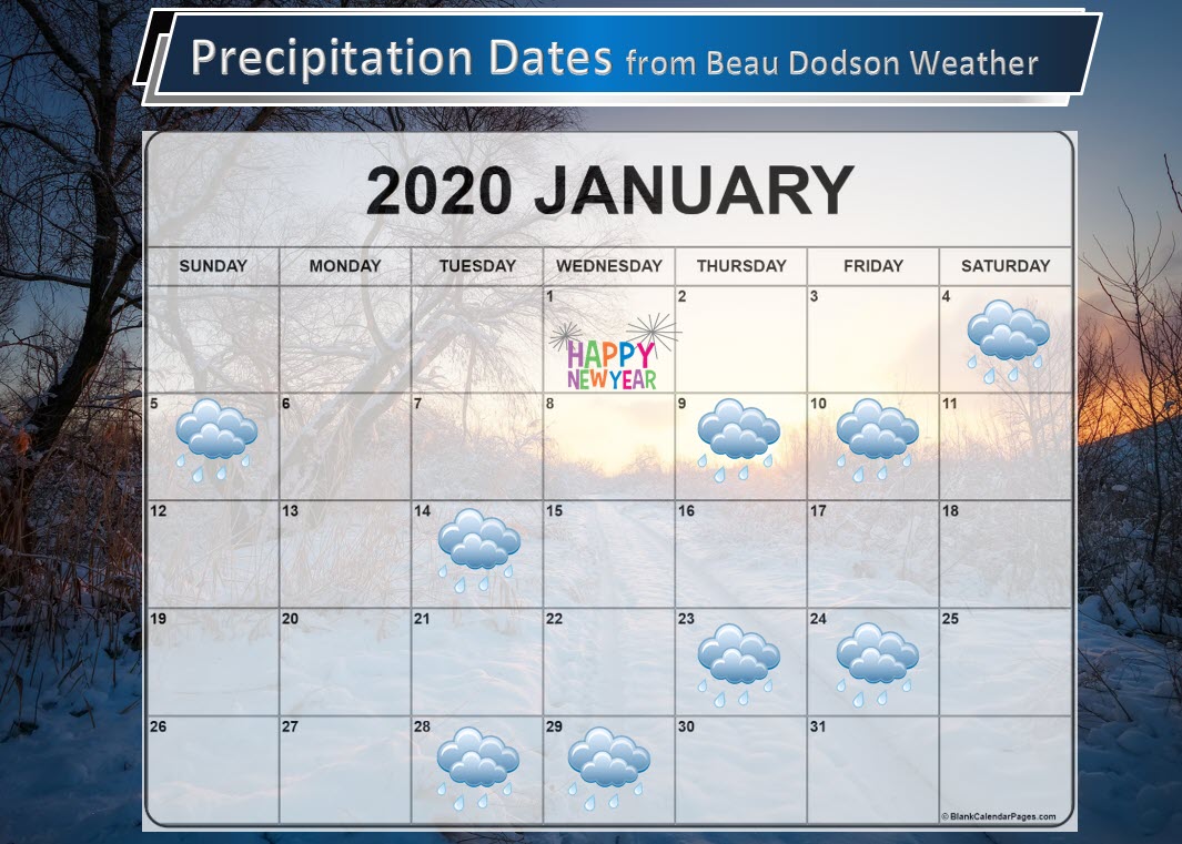
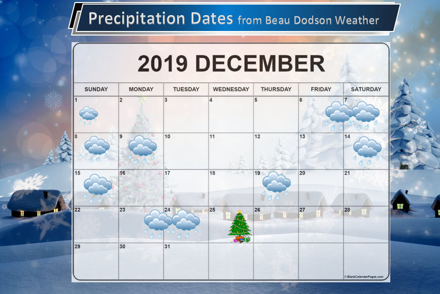
Precipitation Dates.
These are dates that may have precipitation. Monitor the trends in the forecast.
Anything past day seven is very low confidence. Do not make plans based on this forecast.
The icon can mean rain or snow.
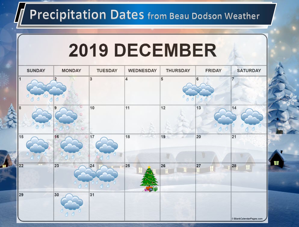
Click to enlarge these graphics.
![]()
![]()
Graphic-cast
Click here if you would like to return to the top of the page.
** These graphic-forecasts may vary a bit from my forecast above **
CAUTION: I have these graphics set to auto-update on their own. Make sure you read my hand-typed forecast above.
During active weather check my handwritten forecast.
Missouri

** These graphic-forecasts may vary a bit from my forecast above **
CAUTION: I have these graphics set to auto-update on their own. Make sure you read my hand-typed forecast above.
During active weather check my handwritten forecast.

.
Illinois
** These graphic-forecasts may vary a bit from my forecast above **
CAUTION: I have these graphics set to auto-update on their own. Make sure you read my hand-typed forecast above.
During active weather check my handwritten forecast.

** These graphic-forecasts may vary a bit from my forecast above **
CAUTION: I have these graphics set to auto-update on their own. Make sure you read my hand-typed forecast above.
During active weather check my handwritten forecast.

** These graphic-forecasts may vary a bit from my forecast above **
CAUTION: I have these graphics set to auto-update on their own. Make sure you read my hand-typed forecast above.
During active weather check my handwritten forecast.

** These graphic-forecasts may vary a bit from my forecast above **
CAUTION: I have these graphics set to auto-update on their own. Make sure you read my hand-typed forecast above.
During active weather check my handwritten forecast.

.
Kentucky
** These graphic-forecasts may vary a bit from my forecast above **
CAUTION: I have these graphics set to auto-update on their own. Make sure you read my hand-typed forecast above.
During active weather check my handwritten forecast.

** These graphic-forecasts may vary a bit from my forecast above **
CAUTION: I have these graphics set to auto-update on their own. Make sure you read my hand-typed forecast above.
During active weather check my handwritten forecast.

** These graphic-forecasts may vary a bit from my forecast above **
CAUTION: I have these graphics set to auto-update on their own. Make sure you read my hand-typed forecast above.
During active weather check my handwritten forecast.

** These graphic-forecasts may vary a bit from my forecast above **
CAUTION: I have these graphics set to auto-update on their own. Make sure you read my hand-typed forecast above.
During active weather check my handwritten forecast.

** These graphic-forecasts may vary a bit from my forecast above **
CAUTION: I have these graphics set to auto-update on their own. Make sure you read my hand-typed forecast above.
During active weather check my handwritten forecast.

.
Tennessee
** These graphic-forecasts may vary a bit from my forecast above **
CAUTION: I have these graphics set to auto-update on their own. Make sure you read my hand-typed forecast above.
During active weather check my handwritten forecast.

** These graphic-forecasts may vary a bit from my forecast above **
CAUTION: I have these graphics set to auto-update on their own. Make sure you read my hand-typed forecast above.
During active weather check my handwritten forecast.

.
Monday through next Monday: None
The National Weather Service defines a severe thunderstorm as one that produces quarter size hail or larger, 58 mph winds or greater, and/or a tornado.
.
Severe Weather Risk Graphic (this is not for regular sub-severe thunderstorms. This graphic is for severe thunderstorms)
The National Weather Service defines a severe thunderstorm as one that produces quarter size hail or larger, 58 mph winds or greater, and/or a tornado.
.
Click here if you would like to return to the top of the page.
Today’s outlook (below).
Light green is where thunderstorms may occur but should be below severe levels.
Dark green is a level one risk. Yellow is a level two risk. Orange is a level three (enhanced) risk. Red is a level four (moderate) risk. Pink is a level five (high) risk.
One is the lowest risk. Five is the highest risk.
Light green is not assigned a number. Light green is where storms may occur but should be below severe levels.
A severe storm is one that produces 60 mph winds or higher, quarter size hail, and/or a tornado. One or more of those is defined as a severe thunderstorm.

The black outline is our local area.

.
Tomorrow’s outlook.
Light green is where thunderstorms may occur but should be below severe levels.
Dark green is a level one risk. Yellow is a level two risk. Orange is a level three (enhanced) risk. Red is a level four (moderate) risk. Pink is a level five (high) risk.
One is the lowest risk. Five is the highest risk. Light green is not assigned a number.


.
Be sure and have WeatherOne turned on in your WeatherTalk accounts. That is the one for tornadoes, severe storms, and winter storms.
Log into your www.weathertalk.com
Click the personal notification settings tab.
Turn on WeatherOne. Green is on. Red is off.

.

Here is the latest graphic from the WPC/NOAA.
.
24-hour precipitation outlook.
.

.
48-hour precipitation outlook.
.
.
.
72-hour precipitation outlook.
.

.
Days one through seven added together. Seven-day rainfall totals.


.
- Calm weather today and tomorrow.
- A fast-moving system will clip our region with showers on Thursday night.
- Rain chances return by Sunday and Monday.
Click here if you would like to return to the top of the page.
.
![]()
.
Weather
.
Advice:
None
.
Weather Forecast Analysis.
A fairly calm weather pattern has settled into the region.
You can expect calm weather today through Thursday morning.
A few clouds. The clouds will make it feel cooler.
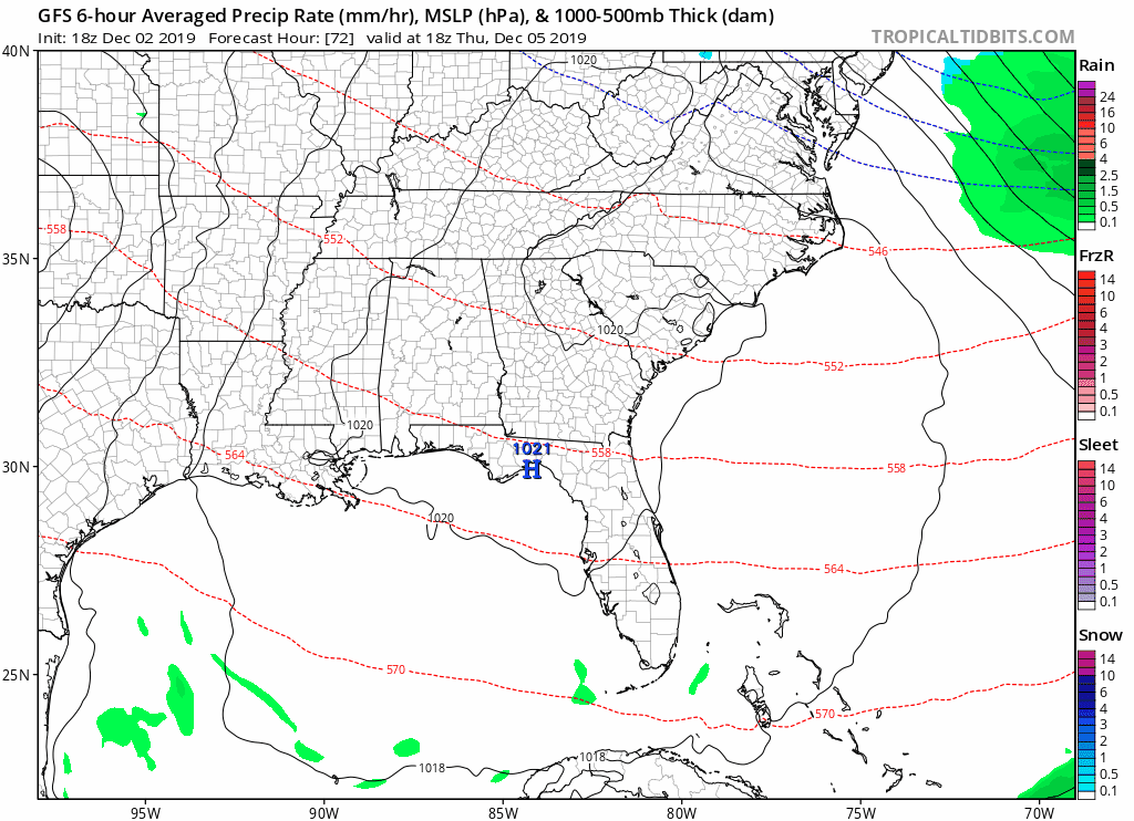
A fast-moving system will move to our south on Thursday night and Friday. This system will intensify as it moves south and southeast of our region.
The end result for our region will be scattered showers. Rain totals will range from 0.00″ to 0.25″. Some areas will likely remain dry.
The system has been trending further south in the model guidance. If that trend continues then rain totals will be even less than mentioned above.
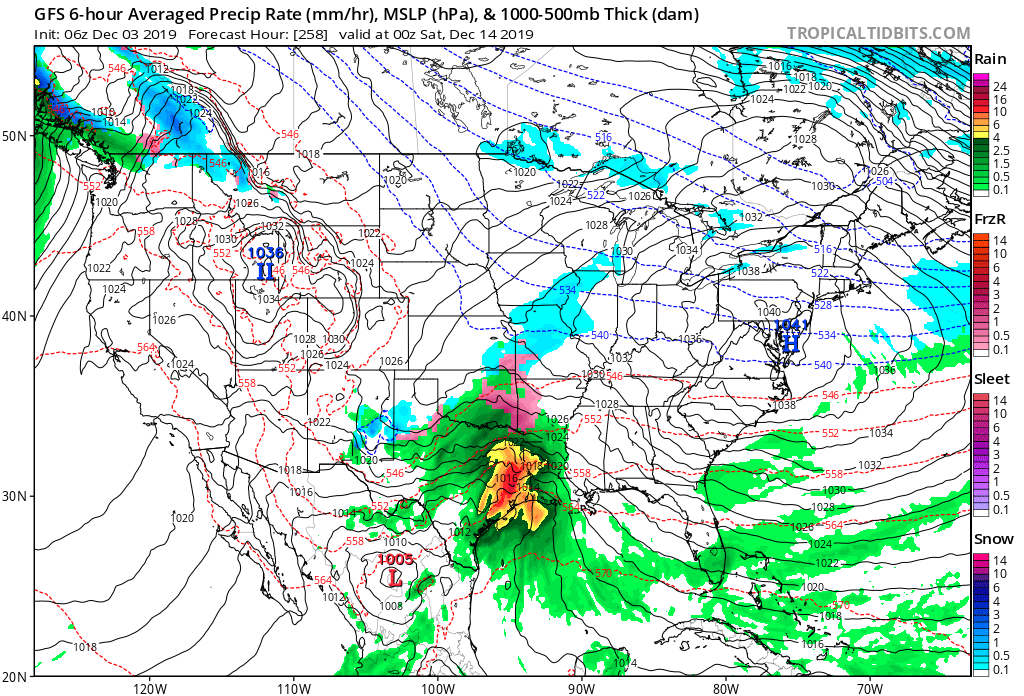
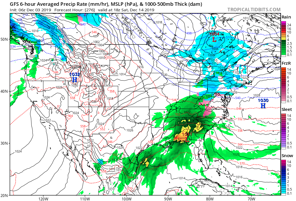
You can see that system here on the GFS model guidance.
The core of the system will remain to our south.
Green is rain. Click to enlarge.
.
That system will exit by Friday morning.
Another system arrives on Sunday and Monday. It may linger into Tuesday.
Model guidance does not agree on the timing of the rain showers.
I went ahead and added rain chances for both Sunday and Monday. This may need adjusting. Monitor updates.
For those wanting a winter storm, I am currently not tracking any.
I am watching the 14th and 15th. A system coming out of the southwest may bring precipitation to the region. There will be some cold air to work with. Too early to know if this will be a rain or frozen event.
.
.

.
Those heading south to Memphis can expect sunny sky conditions on Saturday. It will be chilly in the morning. Morning temperatures will be in the upper 30s. Temperatures will rise into the lower to middle 50s by late morning into the afternoon hours.
Winds will be from the southeast at 6 to 12 mph. No rain.
.You
.
 .
.
Click here if you would like to return to the top of the page.
Again, as a reminder, these are models. They are never 100% accurate. Take the general idea from them.
Timestamp upper left.
Click the animation to expand it.
What should I take from these?
- The general idea and not specifics. Models usually do well with the generalities.
- The time-stamp is located in the upper left corner.
.
GFS Model
This is the future-cast radar. This is what radar might look like with the incoming systems.
Green and yellow are rain, Blue is snow.
.
.
Here are the WPC forecast graphics for the six to ten and eight to fourteen-day period. This is for precipitation and temperatures.
Darker colors equal a higher chance of it happening. Deep red means a high chance that temperatures will be above normal. Dark blue means a high chance that temperatures will be below normal.
The light green colors represent a lower end chance of above-normal rainfall. Dark green means a high chance of precipitation being above normal.
The yellow/orange color means a high chance that precipitation will be below normal.
The 6 to 10-day outlook.
Precipitation

.
Temperatures

.
And the 8 to 14-day outlook.
Precipitation

Temperatures

.
These maps below update several times a day. Occasionally, in between updates, you may see a duplicate day or one out of sync.
Forty-eight-hour temperature outlook.
*****
![]()
These are bonus videos and maps for subscribers. I bring these to you from the BAMwx team. I pay them to help with videos.
The Ohio and Missouri Valley videos cover most of our area. They do not have a specific Tennessee Valley forecast but they may add one in the future.
The long-range video is a bit technical. Over time, you can learn a lot about meteorology from the long-range video.
NOTE: These may not be updated on Saturday and Sunday.

Click here if you would like to return to the top of the page.
These are bonus videos for subscribers.
I hire BAMwx to help with videos.
They do not currently have a Kentucky/Tennessee specific video.
The Ohio Valley video does capture our region.
The long-range video does cover our region.
There may be some differences in the videos vs my forecast thoughts. Keep that in mind.
Videos will be in the app first. Check your WeatherTalk app. Click video tab. You can also log into the www.weathertalk.com website to view videos.
Fresh videos are posted between 8 and 9 am.
Ohio Valley video
.

This video is a bit more meteorologically technical. An in-depth discussion about the coming weeks.
Videos will be in the app first. Check your WeatherTalk app. Click video tab. You can also log into the www.weathertalk.com website to view videos.
Fresh videos are posted between 8 and 9 am.
Long Range VIdeo

Videos will be in the app first. Check your WeatherTalk app. Click video tab. You can also log into the www.weathertalk.com website to view videos.
Fresh videos are posted between 8 and 9 am.
The Missouri Valley Forecast Vide0
.

Key Points: This was written by the BAMwx team. I don’t edit it.
.
Click on the graphics to make them larger.
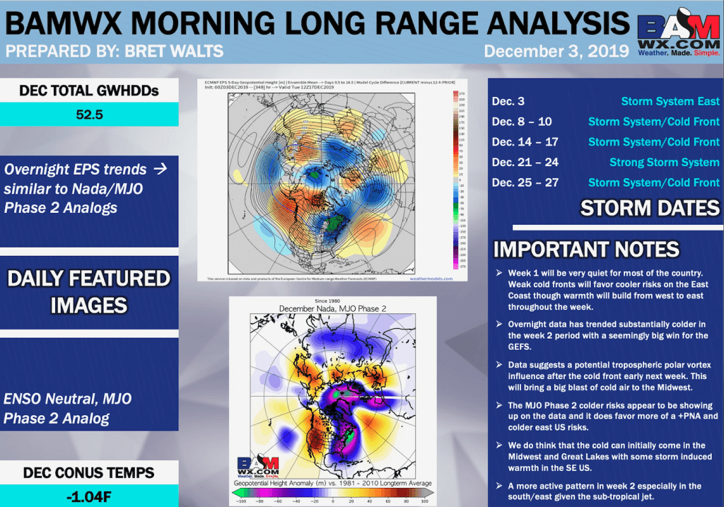
Key Points:
- Week 1 will be very quiet for most of the country. Weak cold fronts will favor cooler risks on the East Coast though warmth will build from west to east throughout the week.
- Overnight data has trended substantially colder in the week 2 period with a seemingly big win for the GEFS.
- Data suggests a potential tropospheric polar vortex influence after the cold front early next week. This will bring a big blast of cold air to the Midwest.
- The MJO Phase 2 colder risks appear to be showing up on the data and it does favor more of a +PNA and colder east US risks.
- We do think that the cold can initially come in the Midwest and Great Lakes with some storm-induced warmth in the SE US.
- A more active pattern in week 2 especially in the south/east given the subtropical jet.
Weeks 1/2 temperature outlooks:
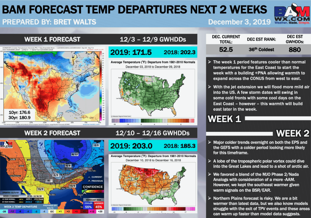
Week 1:
- The week 1 period features cooler than normal temperatures for the East Coast to start the week with a building +PNA allowing warmth to expand across the CONUS from west to east.
- With the jet extension, we will flood more mild air into the US. A few storm dates will swing in some cold fronts with some cool days on the East Coast – however – this warmth will build east later in the week.
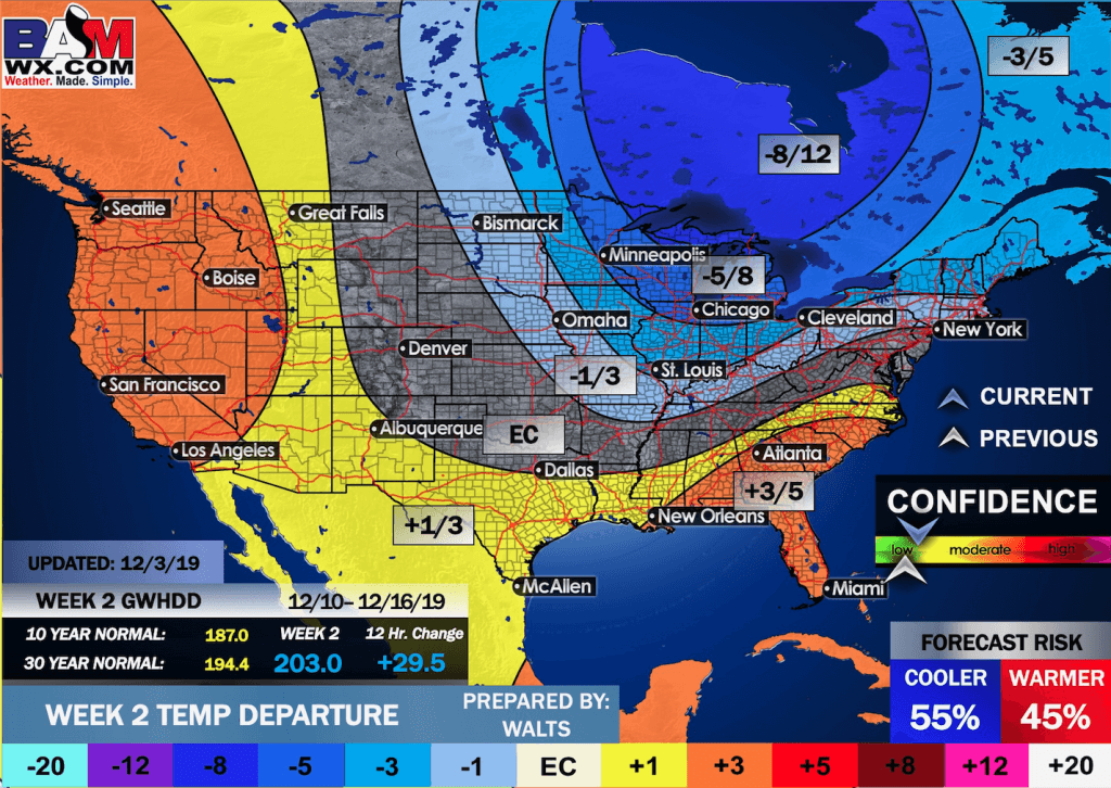
Week 2:
- Major colder trends overnight on both the EPS and the GEFS with a colder period looking more likely for this timeframe.
- A lobe of the tropospheric polar vortex could dive into the Great Lakes and lead to a shot of arctic air.
- We favored a blend of the MJO Phase 2/Nada (Neutral) Analogs with consideration of a more -AAM. However, we kept the southeast warmer given warm signals on the BSR/EAR.
- Northern Plains forecast is risky. We are a bit warmer than the latest data, but we also know models struggle with the exit of TPV (Tropospheric Polar Vortex) events and these areas can warm up faster than model data suggests.
Weeks 1/2 precipitation outlooks:
Week 1:
- The week 1 period features cooler than normal temperatures for the East Coast with a building +PNA allowing warmth to spread in the Central and Western US.
- With the jet extension, we will flood more mild air into the US. A few storm dates will swing in some cold fronts but these will favor the East Coast with cooler risks given the +PNA.
Week 2:
- Major differences in week 2 data with the EPS more than 30 points warmer than the GEFS.
- The EPS builds major Eastern US warmth with a lack of both Pacific and Atlantic blocking.
- There is certainly some support for warmer risks especially southeast with the North Pacific and EAR. Any kind of MJO phase 3 forcing would also support that idea but confidence is very low on MJO influence.
- The biggest risk areas are the Northern Plains and Northeast given the extended jet could force warmth further east and allow cold fronts to move into the northeast US.
Weeks 1/2 precipitation outlooks:
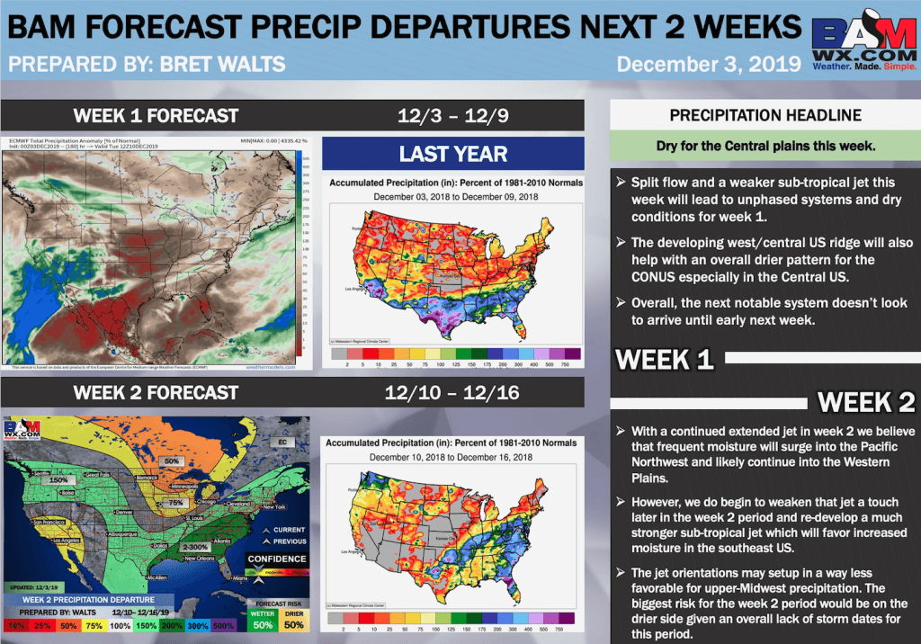
Week 1:
- Split flow and a weaker subtropical jet this week will lead to unphased systems and dry conditions for week 1.
- The developing west/central US ridge will also help with an overall drier pattern for the CONUS, especially in the Central US.
- Overall, the next notable system doesn’t look to arrive until early next week.
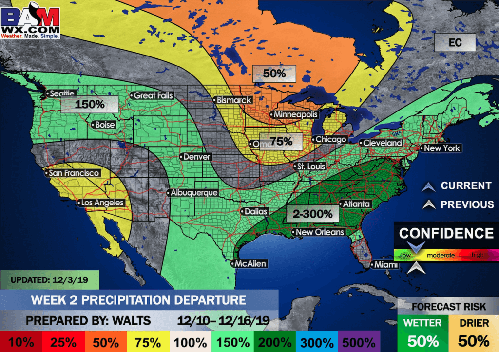
Week 2:
- With a continued extended jet in week two, we believe that frequent moisture will surge into the Pacific Northwest and likely continue into the Western Plains.
- However, we do begin to weaken that jet a touch later in the week 2 period and re-develop a much stronger subtropical jet which will favor increased moisture in the southeast US.
- The jet orientations may set up in a way less favorable for upper-Midwest precipitation. The biggest risk for the week 2 period would be on the drier side given an overall lack of storm dates for this period.
Weeks 3/4 updated outlooks (December 17-30, 2019):
Temperature:
- We are going to stick with the idea of a colder pattern for the second half of December in the Eastern US.
- With continued tropical forcing in MJO P2 along with a falling AAM, we believe that much of the NE tier of the US can be much below normal.
- This will favor Pacific and W. NA high pressure and ridging and allow for surges of cold air to dive into the Eastern US. We do believe that as the Pacific Jet stream retracts following the current extension, the cold could come west for a time into more of the Central US in week 3.
- With that being said, we still favor East US cold in week 4 and to close the month given the MJO Phase 2, -AAM, +SOI and strong correlations for cold via the North Pacific Pattern.
- Biggest risk will be in the Northern Plains where analogs show a lot of variability. Due to the potential of a westward pull back of cold in week 3 for a time, we didn’t go warmer than normal like analogs – but acknowledge that warmth in those areas is a risk especially in week 4.
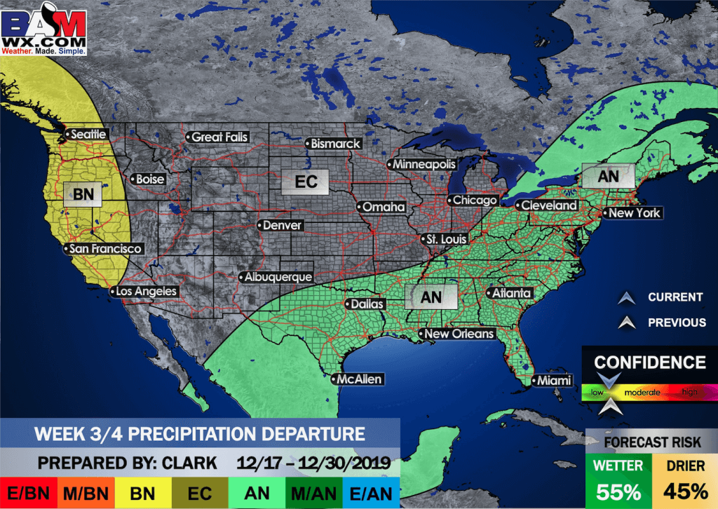
Precipitation:
- With cold situated across the northern and northeastern US, we favor an active storm track especially in the South and Southeastern US into the Northeast.
- An active sub-tropical jet will allow for plenty of moisture in these areas and with an active pattern in the Bering Sea, we see no reason why there will not be numerous storm systems in this period – perhaps numerous winter events granted the cold air source to the north.
- Given the tendency for a +PNA we are going to keep the Pacific NW a bit drier – with the northern stream ridge over the NW and into the Plains which could allow for weak systems in the Plains and stronger phases systems for the Eastern third of the US.
- Via organic methods, two big wintry systems are possible right around Christmas.
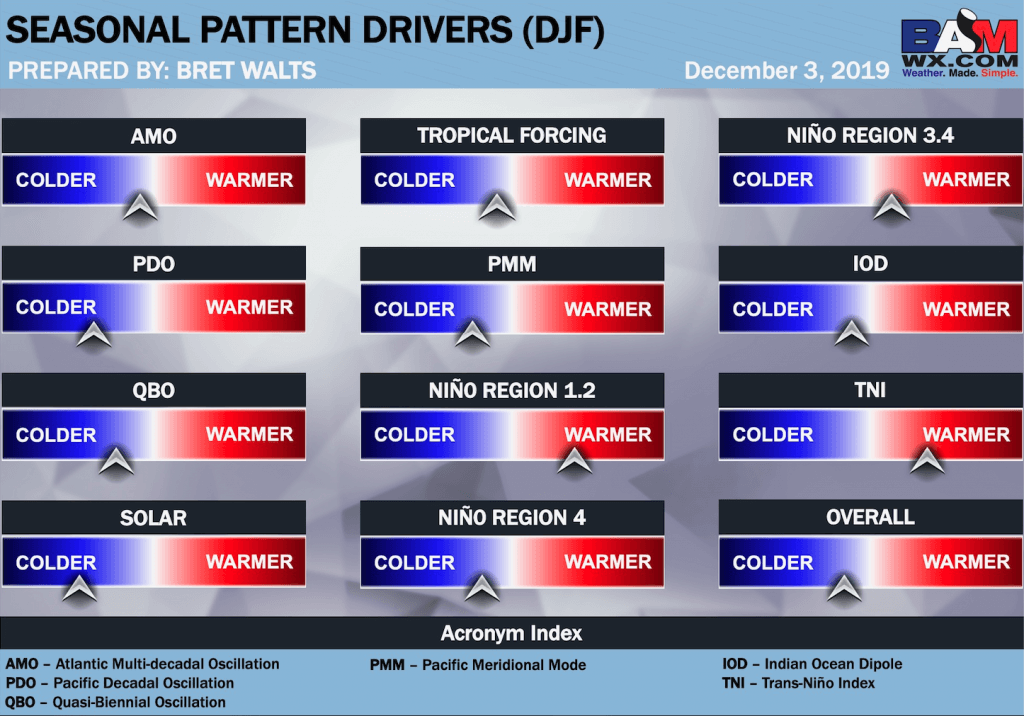
Updated December pattern drivers:

.
.
.
Click here if you would like to return to the top of the page.
.
Average high temperatures for this time of the year are around 50 degrees.
Average low temperatures for this time of the year are around 32 degrees.
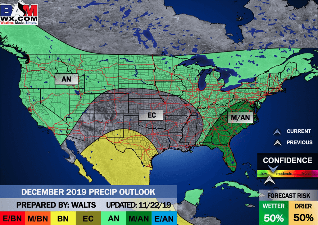
Average precipitation during this time period ranges from 0.90″ to 1.10″
Yellow and orange are above average. Red is much above average. Light blue and blue is below average. Green to purple is much below average.
This outlook covers December 3rd through December 9th
Click on the image to expand it.

.
The precipitation forecast is PERCENT OF AVERAGE. Brown is below average. Green is above average. Blue is much above average.
.

Outlook definitions
EC = Equal chances of above or below average
BN= Below average
M/BN = Much below average
AN = Above average
M/AN = Much above average
E/AN = Extremely above average
Average low temperatures for this time of the year are around 30 degrees
Average precipitation during this time period ranges from 1.00″ to 1.10″
.
This outlook covers December 10th through December 16th
Click on the image to expand it.
.
The precipitation forecast is PERCENT OF AVERAGE. For example, if your average rainfall is 1.00″ and the graphic shows 25%, then that would mean 0.25″ of rain is anticipated.
.

Outlook definitions
EC = Equal chances of above or below average
BN= Below average
M/BN = Much below average
AN = Above average
M/AN = Much above average
E/AN = Extremely above average
Average high temperatures for this time of the year are around 44 degrees
Average low temperatures for this time of the year are around 27 degrees
Average precipitation during this time period ranges from 1.90″ to 2.20″
This outlook covers December 17th through December 30th
Click on the image to expand it.
.
.
The precipitation forecast is PERCENT OF AVERAGE. For example, if your average rainfall is 1.00″ and the graphic shows 10%, then that would mean 0.10″ of rain is anticipated.
.
Outlook definitions
EC= Equal chances of above or below average
BN= Below average
M/BN = Much below average
AN = Above average
M/AN = Much above average
E/AN = Extremely above average
.
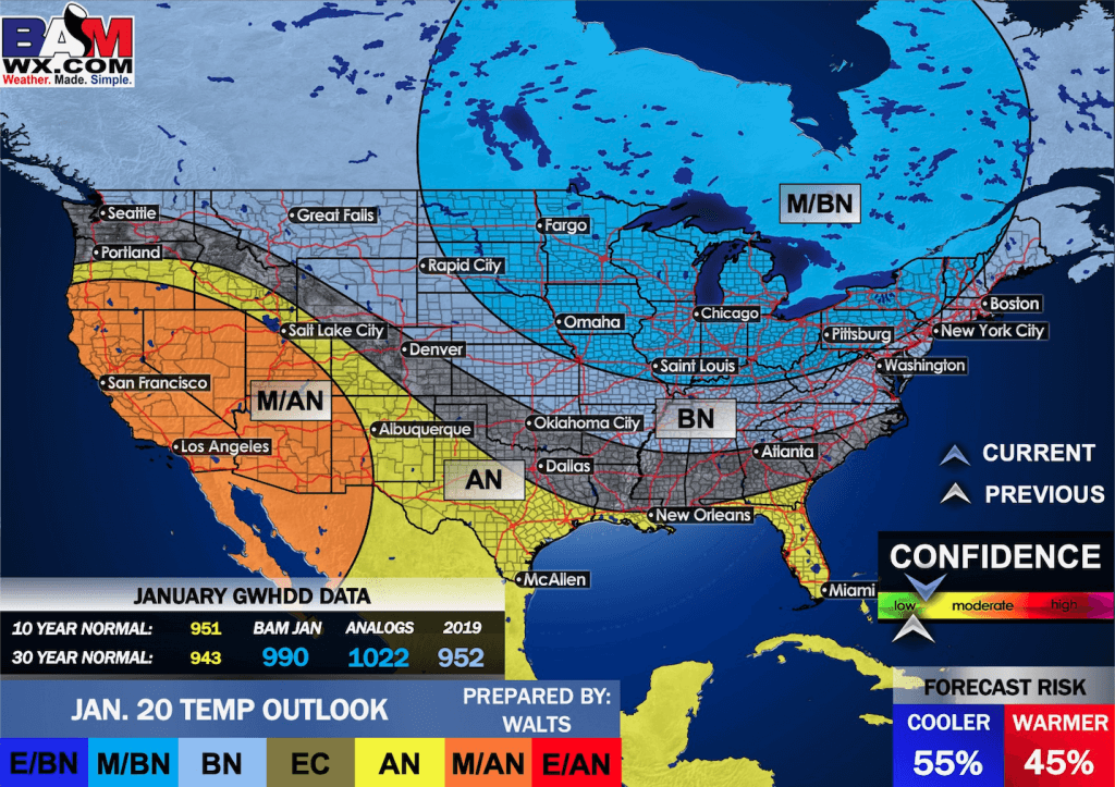
December
Click on the image to expand it.

January
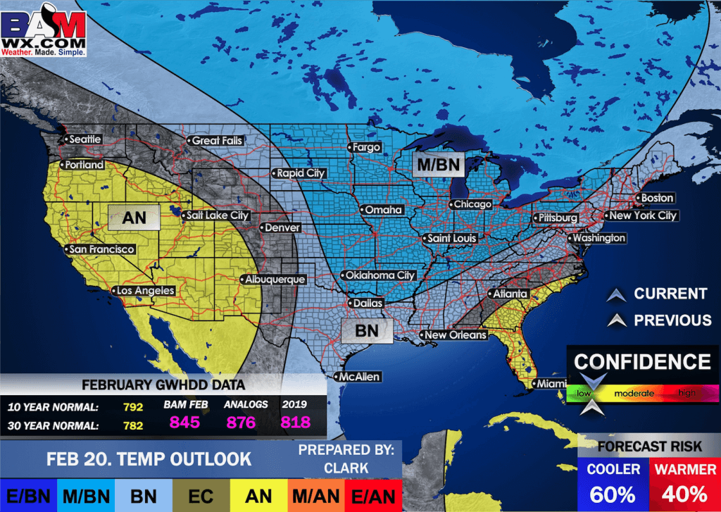
February
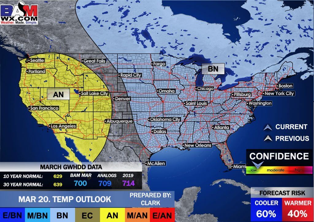
March
Click here if you would like to return to the top of the page..
BAMwx has released its winter forecast. Keep in mind, what you really want to know is not covered in a general winter outlook. What you want to know is how much snow or ice will fall. That is not possible to predict.
The best long-range forecasters can do is to tell you above or below normal temperatures and precipitation.
This initial winter outlook indicates odds favor above-normal temperatures when everything is averaged out from November into March. That does not mean we won’t have cold weather. It just means when you average all of those months together we could end up above normal.
They indicate above-normal snowfall, as well.
Winter analogs. BAMwx found years that have a pattern similar to what we are currently experiencing. Those are called analogs. We can compare previous years with the present.
Their analogs indicate colder than normal across portions of the central and northern United States. They indicate above normal temperatures along the West Coast south and east into Texas.
Blue and purple are below normal (bright green, as well). Yellow and orange are above normal.
Winter Temperature Outlook
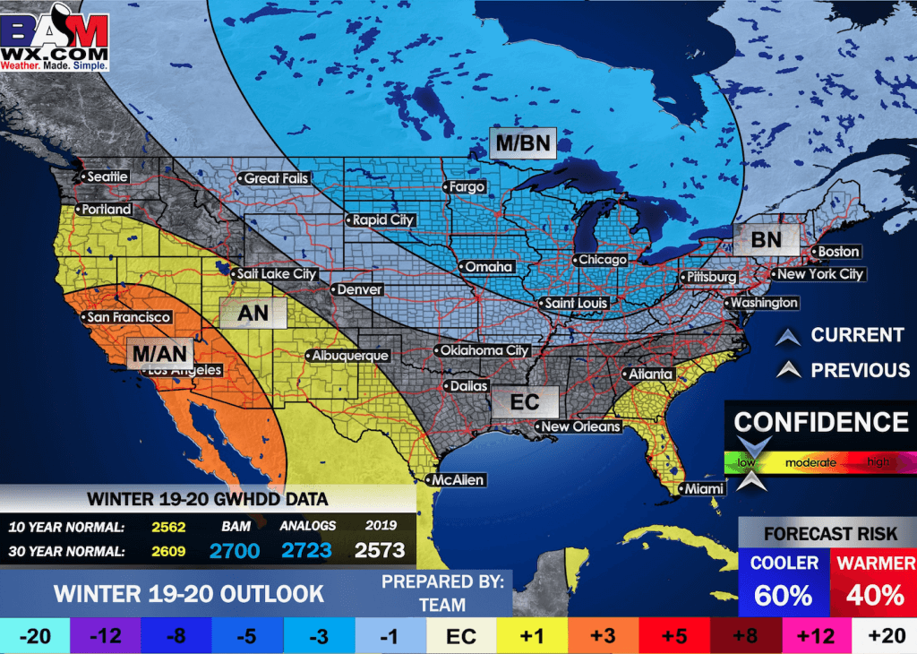
Winter Precipitation

Click image to enlarge
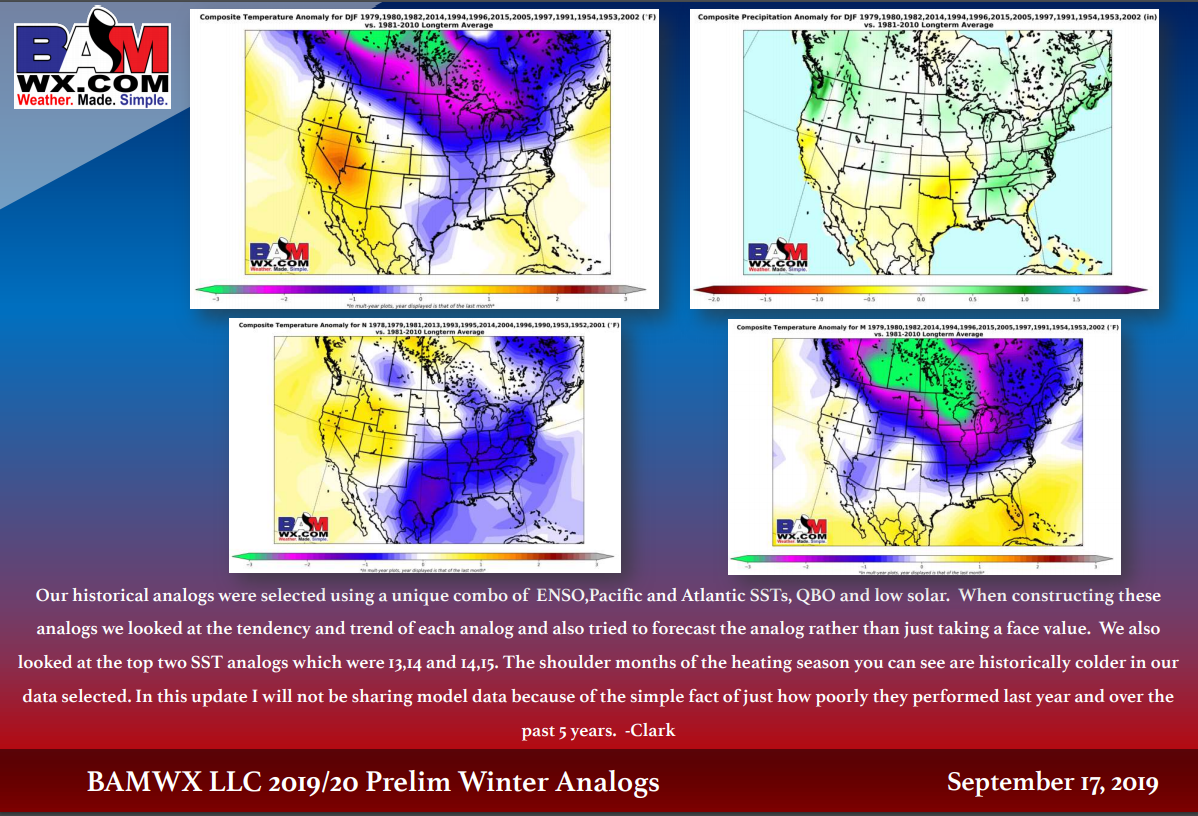
Click image to enlarge.
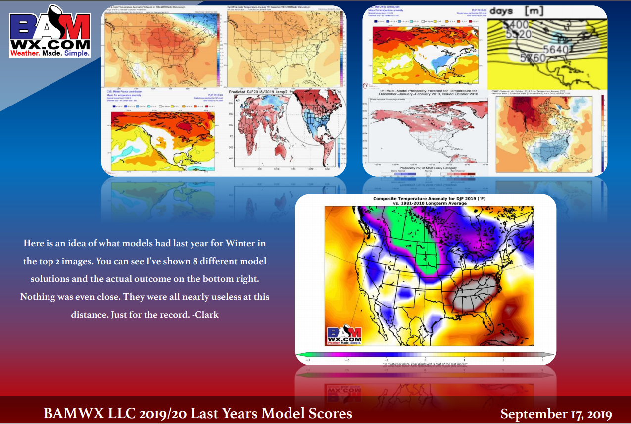
Looking back at last year. None of the models handled last year all that well.
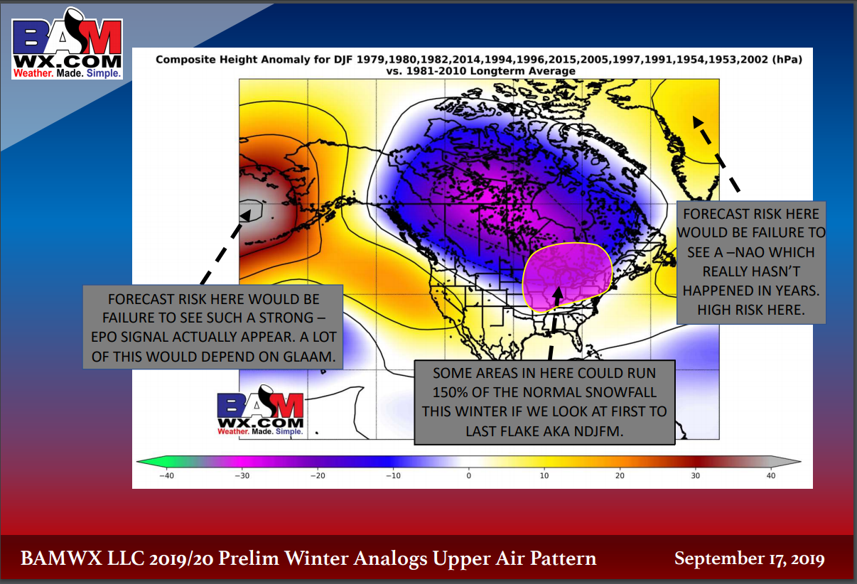
Upper air pattern.
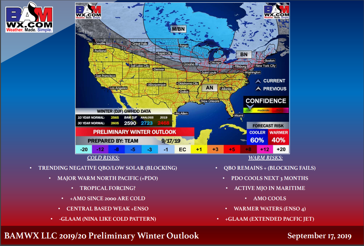
Here is the BAMwx temperature forecast. This covers all of winter. They have us in the above normal temperature zone. Near normal just to our north. For now, they have this marked as a low confidence forecast.
Additional winter forecasts will be posted over the next couple of months. This is the preliminary outlook.
.
Radar Link: Interactive local city-view radars & regional radars.
You will find clickable warning and advisory buttons on the local city-view radars.
If the radar is not updating then try another one. If a radar does not appear to be refreshing then hit Ctrl F5. You may also try restarting your browser.
Not working? Email me at beaudodson@usawx.com
National map of weather watches and warnings. Click here.
Storm Prediction Center. Click here.
Weather Prediction Center. Click here.
.

Live lightning data: Click here.
.

Interactive GOES R satellite. Track clouds. Click here.
GOES 16 slider tool. Click here.
College of Dupage satellites. Click here
.

Here are the latest local river stage forecast numbers Click Here.
Here are the latest lake stage forecast numbers for Kentucky Lake and Lake Barkley Click Here.
.
Did you know that you can find me on Twitter? Click here to view my Twitter weather account.

.

.
Who do you trust for your weather information and who holds them accountable?
I have studied the weather in our region since the late 1970s. I have 40 years of experience in observing our regions weather patterns.
My degree is in Broadcast Meteorology from Mississippi State University and a Bachelor of Science (BS).
I am an NOAA Weather-Ready Nation Ambassador. I am the Meteorologist for McCracken County rescue squad. When asked, I assist Ballard and Massac Counties, as well.
I own and operate the Southern Illinois Weather Observatory and WeatherTalk LLC.
There is a lot of noise on the internet. Over time you should learn who to trust for your weather information.
My forecast philosophy is simple and straight forward.
- Communicate in simple terms
- To be as accurate as possible within a reasonable time frame before an event
- Interact with you on Twitter, Facebook, and the blog
- Minimize the “hype” that you might see on television or through other weather sources
- Push you towards utilizing wall-to-wall LOCAL TV coverage during severe weather events
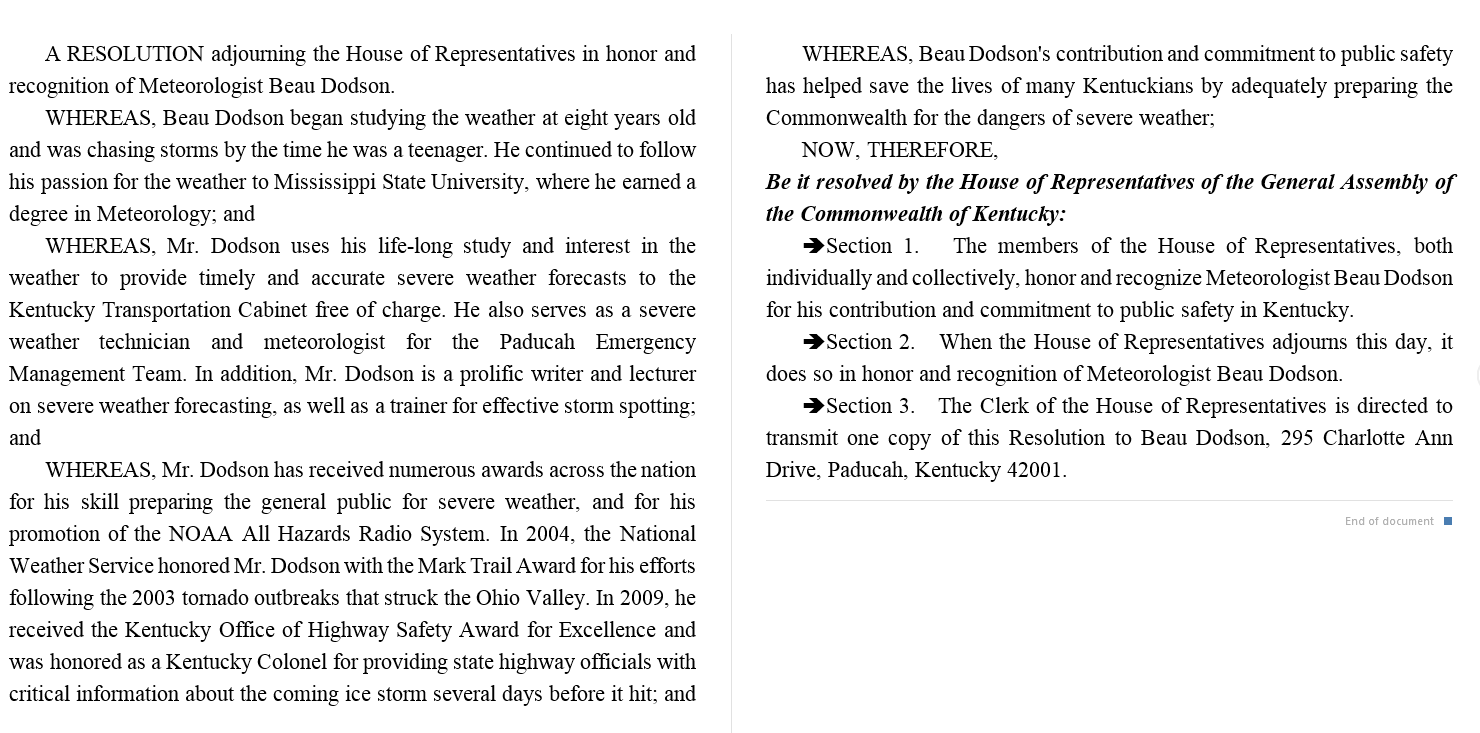
I am a recipient of the Mark Trail Award, WPSD Six Who Make A Difference Award, Kentucky Colonel, and the Caesar J. Fiamma” Award from the American Red Cross.
In 2009 I was presented with the Kentucky Office of Highway Safety Award.
I was recognized by the Kentucky House of Representatives for my service to the State of Kentucky leading up to several winter storms and severe weather outbreaks.
If you click on the image below you can read the Kentucky House of Representatives Resolution.
.

![]()
A new weather podcast is now available! Weather Geeks (which you might remember is on The Weather Channel each Sunday)

.
Our Guest WeatherBrain is the director of the video and social media content for the MyRadar App. Mike Linden, welcome to WeatherBrains!
Joining us as Guest Panelist is former TV meteorologist and current NWS employee Brian Neudorff. Welcome back, Brian!
Other discussions in this weekly podcast include topics like:
- NWS app?
- Pre-Thanksgiving storm?
- Tropical wave east of Leeward Islands
- National Weather Round-Up
- and more!
.
Previous episodes can be viewed by clicking here.
.
Find Beau on Facebook! Click the banner.

.
Find Beau on Twitter! Share your weather photos! @beaudodson

Click here if you would like to return to the top of the page.
Did you know that a portion of your monthly subscription helps support local charity projects? Not a subscriber? Becoming one at www.weathertalk.com
You can learn more about those projects by visiting the Shadow Angel Foundation website and the Beau Dodson News website.
